Аурланд

Аурланд муниципалитет
Аурланд муниципалитет | |
|---|---|
 Вид на Аурландсванген | |
 Флаг | |
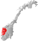 Vestland within Norway | |
 Aurland within Vestland | |
| Coordinates: 60°52′05″N 07°14′36″E / 60.86806°N 7.24333°E | |
| Country | Norway |
| County | Vestland |
| District | Sogn |
| Established | 1 January 1838 |
| • Created as | Formannskapsdistrikt |
| Administrative centre | Aurlandsvangen |
| Government | |
| • Mayor (2023) | Kjell Bøe Bjørgum (Ap) |
| Area | |
| • Total | 1,467.69 km2 (566.68 sq mi) |
| • Land | 1,376.20 km2 (531.35 sq mi) |
| • Water | 91.49 km2 (35.32 sq mi) 6.2% |
| • Rank | #60 in Norway |
| Population (2023) | |
| • Total | 1,775 |
| • Rank | #294 in Norway |
| • Density | 1.3/km2 (3/sq mi) |
| • Change (10 years) | |
| Demonym | Aurlending[1] |
| Official language | |
| • Norwegian form | Nynorsk |
| Time zone | UTC+01:00 (CET) |
| • Summer (DST) | UTC+02:00 (CEST) |
| ISO 3166 code | NO-4641[3] |
| Website | Official website |

Аурландия ( Городской восточный норвежский: ˈˈrlɑn] ) - муниципалитет в графстве Вестленд [ , Норвегия . Он расположен на южной стороне Согнефьордена в районе Сока традиционном . Административный центр - деревня Аурландсванген . Другие деревни включают Бакка , Флом , неудредал и Гудванген .
Муниципалитет площадью 468 квадратных километров (567 кв. Миль) является 60-й по величине по площади из 356 муниципалитетов в Норвегии. Aurland является 294 -м по численности муниципалитета в Норвегии с населением 1775. муниципалитета Плотность населения составляет 1,3 жителя на квадратный километр (3,4/кв. Миль), а его популяция увеличилась на 3,6% за предыдущий 10-летний период. [ 4 ] [ 5 ]
Общая информация
[ редактировать ]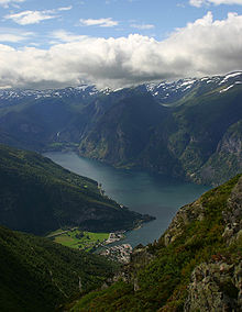
Aurland was established as a municipality on 1 January 1838 (see formannskapsdistrikt law). The original municipality was identical to the Aurland parish (prestegjeld) with the sub-parishes (sokn) of Aurlandsvangen, Flåm, and Undredal. In 1859, the sub-parish of Nærøy was created by separating it from the sub-parish of Undredal. The municipal borders have not changed since 1838.[6]
Name
[edit]The municipality (originally the parish) is named after the old village of Aurland (Old Norse: Aurland) since the first Vangen Church was built there. The first element is aurr which means "gravel" or "moist earth". The last element is land which means "land" or "district".[7]
Coat of arms
[edit]The coat of arms was granted on 22 May 1987. The official blazon is "Azure, a goat buck's head erased argent" (Norwegian: På blå grunn eit avrive sølv geitebukkhovud). This means the arms have a blue field (background) and the charge is the head of a male goat. The goat head has a tincture of argent which means it is commonly colored white, but if it is made out of metal, then silver is used. A goat was considered an appropriate symbol for the municipality since the area is famed for its goat farming and its production of goat cheese. The arms were designed by Inge Rotevatn. The municipal flag has the same design as the coat of arms.[8][9][10]
Churches
[edit]The Church of Norway has four parishes (sokn) within the municipality of Aurland. It is part of the Sogn prosti (deanery) in the Diocese of Bjørgvin.
| Parish (sokn) | Church name | Location of the church | Year built |
|---|---|---|---|
| Flåm | Flåm Church | Flåm | 1667 |
| Nærøy | Bakka Church | Bakka | 1859 |
| Undredal | Undredal Stave Church | Undredal | 1147 |
| Vangen | Vangen Church | Aurlandsvangen | 1202 |
History
[edit]The earliest inhabitants lived by hunting and fishing until they gradually started farming about 2,000 years ago. Agriculture is still important with the rich valley floors and abundant mountain pastures. As in all of western Norway, the area was overpopulated in the middle 19th century, and cotters were forced to clear land far up the mountainsides. This difficulty led to emigration and in the 20-year period after 1845, 1,050 people moved out of the community—most of them moving to America.
Tourism came to the community as early as the middle of the 19th century, in the form of sport fishing and hunting. Tourists from England were dominant during this time and one can still find English names for mountaintops, hunting cabins, and fishing holes.
Later, a different type of tourist came to the region. These tourists came to enjoy the natural beauty of the area. These tourists created a need for jobs in the form of transportation and lodging. Three or four ships would anchor in the Nærøyfjord at a time which created the need for scores of horse-drawn carriages to take the tourists up to Stalheim hotel, located just over the border in Voss municipality to the southwest.[11]
Government
[edit]Aurland Municipality is responsible for primary education (through 10th grade), outpatient health services, senior citizen services, welfare and other social services, zoning, economic development, and municipal roads and utilities. The municipality is governed by a municipal council of directly elected representatives. The mayor is indirectly elected by a vote of the municipal council.[12] The municipality is under the jurisdiction of the Sogn og Fjordane District Court and the Gulating Court of Appeal.
Municipal council
[edit]The municipal council (Kommunestyre) of Aurland is made up of 17 representatives that are elected to four year terms. The tables below show the current and historical composition of the council by political party.
| Party name (in Nynorsk) | Number of representatives | |
|---|---|---|
| Labour Party (Arbeidarpartiet) | 7 | |
| Green Party (Miljøpartiet Dei Grøne) | 1 | |
| Conservative Party (Høgre) | 5 | |
| Centre Party (Senterpartiet) | 3 | |
| Liberal Party (Venstre) | 1 | |
| Total number of members: | 17 | |
Mayors
[edit]The mayors (Nynorsk: ordførar) of Aurland:[32]
- 1838-1839: Jonas Wessel Crøger
- 1841-1841: Torstein Fretheim
- 1842-1843: K. A. Bugge
- 1844-1847: Torstein Fretheim
- 1848-1848: Henrik Christian Borchgrevink
- 1849-1851: Torstein Fretheim
- 1853-1859: Torstein Fretheim
- 1862-1865: Sjur Loven
- 1867-1868: Anders Brekke
- 1868-1871: Torstein Fretheim
- 1872-1879: Lars Ohnstad
- 1881-1885: Eirik Otternes
- 1886-1897: Anders Brekke
- 1899-1907: Peder Skjerdal
- 1909-1925: Olav Sævartveit
- 1926-1928: Jens Lunde
- 1928-1929: Per Wangen
- 1939-1941: Jens Lunde
- 1942-1945: Torstein Skahjem
- 1945-1945: Jens Lunde
- 1946-1959: Jon Ø. Underdahl
- 1960-1963: Ragnvald Winjum (V)
- 1965-1971: Svein Fossheim (Sp)
- 1971-1979: Martin Widme (Ap)
- 1980-1985: Torleiv Gjerløw (Sp)
- 1986-1991: Osvald Turlid (Ap)
- 1992-2003: Ivar Bjarne Underdal (Sp)
- 2003–2011: Olav J. Ellingsen (Sp)
- 2011–2019: Noralv Distad (H)
- 2019–2023: Trygve Skjerdal (Sp)
- 2023-present: Kjell Bøe Bjørgum (Ap)[33]
Police
[edit]In 2016, the chief of police for Vestlandet formally suggested a reconfiguration of police districts and stations. He proposed that the police station in Aurland be closed.[34]
Geography
[edit]
Aurland lies 200 kilometres (120 mi) from the west coast of Norway in the eastern part of Vestland county, along the Aurlandsfjorden and the Nærøyfjorden. These are branches that flow off of the world's longest and deepest fjord, the Sognefjorden.
Aurland is bordered by four municipalities in Vestland county: Lærdal to the north-east and Vik to the west, Voss to the south-west, and Ulvik to the south. It is also bordered by one municipality in Buskerud county: Hol to the south-east.
Most of the area is composed of fjords and mountains with small populated areas concentrated in the lower river valleys, the largest of which is the Aurlandsdalen. The main village areas include Aurlandsvangen, Gudvangen, Undredal, Flåm, and Vassbygdi.
Wild and beautiful nature dominate the community from the fjords to mountaintops that are 1,200 to 1,800 metres (3,900 to 5,900 ft) above sea level. There are two permanent glaciers in Aurland: Storskavlen and Blåskavlen.[11]
The Aurlandsfjellet mountains separate Aurland from the neighboring municipality to the east, Lærdal. The Lærdal Tunnel, the longest in the world as of 2014, cuts through the mountains connecting the two municipalities. The Gudvanga Tunnel connects the villages of Gudvangen and Undredal in southwestern Aurland.
Nature
[edit]Climate
[edit]Aurland has a typical inland climate with mild winters at the lower levels, early springs, and warm summers. A yearly average of 470 millimetres (19 in) of precipitation make Aurland one of the driest areas in Norway. In comparison, Bergen has 2,250 millimetres (89 in) of precipitation per year.[11]
Vegetation
[edit]
Aurland has rich and varied flora, which is more typical of eastern rather than western Norway. The mountain plant life is especially rich since the bedrock contains calcium rich deposits of phyllite.[11]
Geology
[edit]The oldest bedrock in Aurland are Precambrian basement rocks which crop out in tectonic windows in the north-eastern part of the municipality. This basement unit is mainly composed of granites, granodiorites and gneisses and is overlain by a nappe unit of cambro-silurian phyllite and mica schist of varying thickness. This is in turn overlain by a second nappe unit, called the Jotundekket (“Jokun Nappe”), which consists of Precambrian, mainly magmatic rocks which are more or less metamorphosed into gneisses and amphibolite.[35]
Part of the scenery took its shape 9,000 years ago, at the end of the ice age. The ice's advance was either halted or continued, according to the climatic conditions, and moraine ridges and gravel terraces were deposited along the glacier front. They are still visible today south of the Flåm church.[36]
On the western side of the Aurlandsfjord, there is rock that was pushed up into mountain ranges several million years ago. The fjord itself was gouged out of an earlier valley. Aurlandsvangen is typical of the lower areas, lying on an old river delta—the land is very flat and fertile. The mountainsides are steep causing frequent rock slides and avalanches.[11]
The lakes Nyhellervatnet and Fretheimsdalsvatnet are located in Aurland.
Attractions
[edit]UNESCO World Heritage Site
[edit]The West Norwegian Fjords of Geirangefjord and Nærøyfjord were added to UNESCO's World Heritage Site list in 2005. The two fjords are situated 120 kilometres (75 mi) from each other and they are separated by the Jostedalsbreen glacier. The World Heritage Site possesses a unique combination of glacial landforms at the same time as each area is characterised by its own outstanding beauty. The Nærøyfjord areas in this site stretch through the municipalities of Aurland, Lærdal, Vik, and Voss.[37]

Aurlandsdalen Valley
[edit]

The Aurlandsdalen valley is a well known hiking trail in Norway with its fabulous nature and contrasting countryside. The valley is rich in history and packed with culture. One can take the hike in several stages: From Geiteryggen where the path starts, it is a four-hour hike to Steinbergdalen. There are beautiful views of mountain peaks, snow glaciers, and lakes. In Steinbergdalen you will find Steinbergdalen mountain lodge which opened in 1895.[36]
Flåmsbana Railway
[edit]The Flåm Railway is a masterpiece in engineering which is one of the most exciting railway journeys in the world. This journey from Myrdal to Flåm is twelve miles long (19 km), a descent of 866 metres (2,841 ft). It has 20 tunnels with a total length of almost 6 kilometres (3.7 mi). About 80% of the Flåm railway has a maximum gradient of 5.5%. To cope with the enormous change in height over such a short stretch, the track runs partly through tunnels which spiral in and out of the mountainside. The gradient is quite exceptional for a normal railway and the carriages are fitted with five different brake systems, any one of which is sufficient to stop the train.[36]
Undredal Stavkyrkje
[edit]The Undredal Stave Church is a simple, small one-nave church that was built around 1150. It is located in the village of Undredal. It is one of the oldest preserved stave churches in Norway.[37]
Vangen Kyrkje
[edit]The Vangen Church was built in 1202. The church is built in the early Gothic style influenced by English architecture. A document written in 1714 tells us that English merchants used to stay in Aurland during long periods to buy different articles and they are supposed to have taken part in the building of the church. Most likely they would have been the master builders.
In 1725, the Danish-Norwegian government was experiencing financial problems and King Frederick IV sold the church. The church remained as private property until the late 19th century. Then the municipality bought Vangen church back for 500 kroner.
At the last restoration in 1926, the original colors and designs were uncovered. Then the ceiling was taken away and the baldachin over the pulpit was brought back again. A new altarpiece was made. The Norwegian artist Emanuel Vigeland made the stained glass windows (two of the windows in the chancel illustrate the Parable of the Prodigal Son, and the one in the middle is Jesus Christ, the Savior).[36]
Sightseeing
[edit]- Kjelfossen is a waterfall located near the village of Gudvangen
- Kjosfossen and Rjoandefossen are waterfalls that can be seen from the Flåmsbana railway
- The Stegastein viewpoint was constructed in 2006 with views of the surrounding fjords and valleys.

Notable people
[edit]- Absalon Pederssøn Beyer (ca. 1528 in Aurland – 1575), a Norwegian author, lecturer, and Lutheran clergyman
- Ragnvald Gjerløw (1853 in Aurland – 1936), a Norwegian priest and writer
- Per Sivle (1857 in Flåm – 1904), a Norwegian poet, novelist, and newspaper editor
- Ragnvald Winjum (1917–1965), a Norwegian jurist, politician, farmer, and attorney who lived in Aurland from 1953 and became the Mayor of Aurland municipality
- Keldian (formed 2005 in Aurland), a Norwegian power metal band
References
[edit]- ^ "Navn på steder og personer: Innbyggjarnamn" (in Norwegian). Språkrådet.
- ^ "Forskrift om målvedtak i kommunar og fylkeskommunar" (in Norwegian). Lovdata.no.
- ^ Bolstad, Erik; Thorsnæs, Geir, eds. (26 January 2023). "Kommunenummer". Store norske leksikon (in Norwegian). Kunnskapsforlaget.
- ^ Statistisk sentralbyrå. "Table: 06913: Population 1 January and population changes during the calendar year (M)" (in Norwegian). Archived from the original on 26 May 2020. Retrieved 26 January 2020.
- ^ Statistisk sentralbyrå. "09280: Area of land and fresh water (km²) (M)" (in Norwegian). Archived from the original on 26 May 2020. Retrieved 26 January 2020.
- ^ Jukvam, Dag (1999). Historisk oversikt over endringer i kommune- og fylkesinndelingen (PDF) (in Norwegian). Statistisk sentralbyrå. ISBN 9788253746845. Archived (PDF) from the original on 1 September 2012. Retrieved 20 October 2017.
- ^ Rygh, Oluf (1919). Norske gaardnavne: Nordre Bergenhus amt (in Norwegian) (12 ed.). Kristiania, Norge: W. C. Fabritius & sønners bogtrikkeri. p. 107. Archived from the original on 9 July 2023. Retrieved 8 July 2023.
- ^ "Civic heraldry of Norway - Norske Kommunevåpen". Heraldry of the World. Archived from the original on 8 October 2022. Retrieved 13 May 2023.
- ^ "Aurland, Sogn og Fjordane (Norway)". Flags of the World. Archived from the original on 23 January 2022. Retrieved 13 May 2023.
- ^ "Godkjenning av våpen og flagg". Lovdata.no (in Norwegian). Norges kommunal- og arbeidsdepartementet. 22 May 1987. Archived from the original on 20 April 2023. Retrieved 13 May 2023.
- ^ Jump up to: a b c d e "About Aurland". Aurland Kommune. 31 October 2003. Archived from the original on 7 February 2009. Retrieved 19 June 2008.
- ^ Hansen, Tore; Vabo, Signy Irene, eds. (20 September 2022). "kommunestyre". Store norske leksikon (in Norwegian). Kunnskapsforlaget. Archived from the original on 27 March 2019. Retrieved 14 October 2022.
- ^ «Муниципальные выборы 2023 - Вестленд» . Избирательный дирекция . Получено 21 января 2024 года .
- ^ «Муниципальные выборы 2019 - Вестленд» . Избирательный дирекция . Получено 29 октября 2019 года .
- ^ Подпрыгнуть до: а беременный в дюймовый «Таблица: 04813: члены местных советов, по партийным/избирательным списку на выборах муниципального совета (M)» (на норвежском языке). Статистика Норвегия. Архивировано из оригинала 19 апреля 2020 года . Получено 30 октября 2019 года .
- ^ «Муниципальные выборы 2011 - Sogn og fjordane» . Избирательный дирекция . Получено 29 октября 2019 года .
- ^ «Муниципальные выборы 1995 года» (PDF) (на норвежском языке). Осло Конгвингер: Статистика Норвегия. 1996. Архивировал (PDF) из оригинала 20 сентября 2014 года . Получено 18 февраля 2020 года .
- ^ «Муниципальные выборы 1991 года» (PDF) (на норвежском языке). Осло Конгвингер: Статистика Норвегия. 1993. Архивировал (PDF) из оригинала 22 мая 2015 года . Получено 18 февраля 2020 года .
- ^ «Муниципальные выборы 1987 года» (PDF) (на норвежском языке). Осло Конгвингер: Статистика Норвегия. 1988. Архивировал (PDF) из оригинала 19 октября 2014 года . Получено 18 февраля 2020 года .
- ^ «Муниципальные выборы 1983 года» (PDF) (на норвежском языке). Осло Конгвингер: Статистика Норвегия. 1984. Архивировал (PDF) из оригинала 19 октября 2014 года . Получено 18 февраля 2020 года .
- ^ «Муниципальные выборы 1979 года» (PDF) (на норвежском языке). Осло: статистика Норвегия. 1979. Архивировал (PDF) из оригинала 29 сентября 2014 года . Получено 18 февраля 2020 года .
- ^ «Муниципальные выборы 1975 года» (PDF) (на норвежском языке). Осло: статистика Норвегия. 1977. Архивировал (PDF) из оригинала 15 марта 2016 года . Получено 1 мая 2020 года .
- ^ «Муниципальные выборы 1972 года» (PDF) (на норвежском языке). Осло: статистика Норвегия. 1973. Архивировал (PDF) из оригинала 21 апреля 2016 года . Получено 1 мая 2020 года .
- ^ «Муниципальные выборы 1967 года» (PDF) (на норвежском языке). Осло: статистика Норвегия. 1967. Архивировал (PDF) из оригинала 21 апреля 2016 года . Получено 1 мая 2020 года .
- ^ «Муниципальные выборы 1963 года» (PDF) (на норвежском языке). Осло: статистика Норвегия. 1964. Архивировал (PDF) из оригинала 21 апреля 2016 года . Получено 1 мая 2020 года .
- ^ «Муниципальные выборы и выборы мэра 1959 года» (PDF) (на норвежском языке). Осло: статистика Норвегия. 1960. Архивировал (PDF) из оригинала 17 марта 2016 года . Получено 1 мая 2020 года .
- ^ «Муниципальные выборы и выборы мэров 1955 года» (PDF) (на норвежском). Осло: статистика Норвегия. 1957. Архивировал (PDF) из оригинала 14 февраля 2020 года . Получено 1 мая 2020 года .
- ^ «Муниципальные выборы и выборы мэра 1951 года» (PDF) (на норвежском). Осло: статистика Норвегия. 1952. Архивировал (PDF) из оригинала 17 марта 2016 года . Получено 1 мая 2020 года .
- ^ «Муниципальные выборы и выборы мэра 1947 года» (PDF) (на норвежском языке). Осло: статистика Норвегия. 1948. Архивировал (PDF) из оригинала 16 марта 2016 года . Получено 1 мая 2020 года .
- ^ «Муниципальные выборы и выборы мэра 1945 года» (PDF) (на норвежском языке). Осло: статистика Норвегия. 1947. Архивировал (PDF) из оригинала 25 августа 2014 года . Получено 1 мая 2020 года .
- ^ «Муниципальные выборы и выборы мэра 1937 года» (PDF) (на норвежском языке). Осло: статистика Норвегия. 1938. Архивировал (PDF) из оригинала 6 марта 2016 года . Получено 1 мая 2020 года .
- ^ «Мэр муниципалитета Аурланда» . NRK Fyklesleksikon . Архивировано из оригинала 14 мая 2023 года . Получено 13 мая 2023 года .
- ^ «Мэр» . Аурланд муниципалитет (на норвежском языке).
- ^ Fjelltveit, ingvild; Раунхольм, за Видар (20 декабря 2016 г.). «Предлагает закрыть 17 офиса шерифа в западном полицейском округе» . НРК Ордаленд (на норвежском языке). Архивировано с оригинала 5 марта 2017 года . Получено 20 октября 2017 года .
- ^ Noralf Rye, Per Einar Faugli (1994): геология и геоморпология округа Аурланд. Норвежский журнал географии . 48 (1–2): 13–22, doi : 10.1080/00291959408552322 .
- ^ Подпрыгнуть до: а беременный в дюймовый Джонсон, Джон Эрик. «Муниципалитет Аурланда» . Архивировано из оригинала 17 августа 2005 года . Получено 20 июня 2008 года .
- ^ Подпрыгнуть до: а беременный "Аурландия" . GONORWAY.NO. Архивировано из оригинала 2 февраля 2017 года . Получено 20 июня 2008 года .
Внешние ссылки
[ редактировать ] СМИ, связанные с Aurland в Wikimedia Commons
 - Муниципальный информационный бюллетень из статистики Норвегии (на норвежском языке)
- Туристическая комиссия Аурда и Ларддала
- Мирдал
- Официальный сайт Aurland
- Карта пеших походов Скарвхеймен
Вестерленд округ, Норвегия | |||||||||||||
|---|---|---|---|---|---|---|---|---|---|---|---|---|---|
| |||||||||||||
 | Города и поселки | ||||||||||||
| Муниципалитеты |
| ||||||||||||
| Базы данных управления авторитетом : географический |
|---|