Семинол-Хот-Спрингс, Калифорния

Семинол-Хот-Спрингс, Калифорния | |
|---|---|
 Парк передвижных домов Семинол-Спрингс недалеко от Корнелла | |
 Seminole Hot Springs, California | |
| Coordinates: 34°06′26″N 118°47′26″W / 34.10722°N 118.79056°W | |
| Country | |
| State | |
| County | Los Angeles |
| Elevation | 284 m (932 ft) |
| Time zone | UTC-8 (Pacific (PST)) |
| • Summer (DST) | UTC-7 (PDT) |
| Area code | 818 |
| GNIS feature ID | 1661420[1] |
| Seminole Hot Springs, California | |
|---|---|
 Los Angeles Evening Express, 1924: Wheeler's Hot Springs, the plunge at Seminole Hot Springs, Matilija Hot Springs, Soboba Hot Springs | |
 | |
| Type | geothermal |
| Discharge | 65 liters/minute[2] |
| Temperature | 116 °F (47 °C) |
| Depth | 2,600 feet (790 m) |
Семинол-Хот-Спрингс — некорпоративное сообщество в округе Лос-Анджелес , Калифорния , США . Горячие источники Семинол расположены в горах Санта-Моники недалеко от Корнелла , в 3,6 мили (5,8 км) к юго-юго-востоку от холмов Агура , на высоте 932 фута (284 м).
История
[ редактировать ]Поселение возникло как курорт, построенный вокруг горячего источника. Источники были впервые обнаружены в 1911 году, а курорт закрылся в 1959 году. [3] Как и в случае с Радиум-Сульфур-Спрингс и Бимини-Хот-Спрингс в других местах округа Лос-Анджелес . [4] Воды горячих источников Семинол были «обнаружены», а затем коммерциализированы после того, как нефтяники обнаружили воду вместо нефти. [5] Крупные пожары прошли в этом районе в 1930-х и 1940-х годах. [6] по Лос-Анджелесу» 1941 года В «Американском путеводителе Семинол-Хот-Спрингс описывался как «круглогодичный оздоровительный и развлекательный курорт с источниками, коттеджами, банями, бассейном с минеральной водой под открытым небом и кафе, утопающим в роще платанов ниже уровня реки. дорога." [7]
Now essentially a suburb of the Agoura–Calabasas era, there is a mobile home community at the location. The Woolsey Fire of 2018 destroyed 100 of the 215 mobile homes at Seminole Hot Springs.[5]
Additional images
[edit]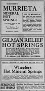 Stack of ads for SoCal spring resorts in the Los Angeles Evening Express, 1926: Guenther's Murrieta Mineral Hot Springs, Gilman Relief Hot Springs, Wheelers Hot Mineral Springs, and Seminole Hot Springs
 Route map to Seminole Hot Springs (Pepperdine University, Malibu Historical Collection, Anderson00122)


See also
[edit]References
[edit]- ^ "Seminole Hot Springs". Geographic Names Information System. United States Geological Survey, United States Department of the Interior.
- ^ Higgins, Chris T.; Therberge, Albert E. Jr.; Ikelman, Joy A. (1980). Geothermal Resources of California (PDF) (Map). NOAA National Geophysical Center. Sacramento: California Department of Mines and Geology.
- ^ Morrison, Patt (2021-12-28). "From sacred to profane: A brief history of Southern California's hot springs". Los Angeles Times. Retrieved 2023-11-01.
- ^ Waring, Gerald Ashley (January 1915). Springs of California. Water-Supply Paper no. 338–339 (Department of the Interior, United States Geological Survey Water-Supply Papers). Washington, D.C.: U.S. Government Printing Office. pp. 71–72. hdl:2027/uc1.b3015436. Retrieved 2023-11-01 – via HathiTrust.
- ^ Jump up to: a b Megli-Thuna, Dawn (2018-12-13). "Seminole Springs, a former mountain retreat". The Acorn - Serving Agoura Hills, Calabasas, Oak Park & Westlake Village. Retrieved 2023-11-10.
- ^ Greene, Linda W. (1980). A Historical Survey of the Santa Monica Mountains: Preliminary Historic Resource Study, Santa Monica Mountains National Recreation Area. Historic Preservation Branch, Pacific Northwest/Western Team, Denver Service Center, National Park Service, U.S. Department of the Interior. p. 41.
- ^ "Los Angeles; a guide to the city and its environs". HathiTrust. pp. 383–384. hdl:2027/mdp.39015029508374. Retrieved 2023-11-11.

Эта округом Лос-Анджелес, штат Калифорния, статья, связанная с незавершена . Вы можете помочь Википедии, расширив ее . |