Кейбул Ламджао Национальный парк

| Кейбул Ламджао Национальный парк | |
|---|---|
МСКН категория II ( национальный парк ) | |
 Опекуенный сангайский оленя ( Cervus eldi Eldi ) | |
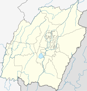 | |
| Расположение | Район Бишнупур , Манипур , Индия |
| Ближайший город | Moirang , Imphal |
| Координаты | 24 ° 30′00 ″ с.ш. 93 ° 46′00 ″ E / 24,50000 ° N 93,76667 ° E |
| Область | 40 км 2 (15 кв. МИ) |
| Учредил | 28 марта 1977 года |
| Руководящий орган | Правительство Индии , правительство Манипура |
| веб - | |
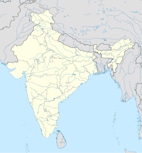
Национальный парк Keibul Lamjao ( Meitei : Keibul Lamjao Leipakki Lampak ) - национальный парк в районе Бишнупур штата Манипур на северо -востоке Индии Это 40 км 2 (15,4 кв. Миль) в районе, единственном плавуческом национальном парке в мире и неотъемлемой частью озера Локтак . [ 1 ] [ 2 ] В настоящее время он находится под предварительными списками сайтов Всемирного наследия ЮНЕСКО под названием « Заповедная зона Кейбул Ламджао (KLCA) » , дополнительно охватывая буфер озера Локтак (140 кв. Км) и Pumlen Pat (43 кв. Км). [ 3 ] [ 4 ]
Национальный парк характеризуется плавающим разложенным растительным материалом на местном уровне, называемом Фумди . Он был создан в 1966 году как заповедник дикой природы для сохранения естественной среды обитания оленя, находящегося под угрозой исчезновения, ( Cervus eldi Eldi ). В 1977 году он был выпущен как национальный парк. [ 5 ] [ 6 ]
История
[ редактировать ]Олень с бровью, который был впервые обнаружен в Манипуре в 1839 году и назван Червус Эльди Элди в 1844 году в честь лейтенанта Перси Эльда-британского офицера, был сообщенным . в 1951 году Парк район эколога и фотографа EP Gee оленей ELD , который потребовал объявления этой области резервного парка как национальный парк для защиты и сохранения оленей, который теперь называется подвидом , или сангай на языке мейтеи (чтобы отличить его Из двух других подвидов, найденных в Бирме и Таиланде , которые называются Cervus eldii Thamin и Cervus eldii Siamensis , а также в Камбодже , Китае , Лаосе , Таиланде , Вьетнаме и острове Хайнань ). У этого есть гордость в фольклоре и культуре штата Манипур и является государственным животным Манипура. Из небольшого стада из 14 оленей в 1975 году его население было 155 в 1995 году, а согласно последней переписи дикой природы, проведенной в марте 2016 года, его число выросло до 260. [ 7 ]
География и топография
[ редактировать ]Парк представляет собой болото с плавающей массой растительности, созданной начислением органического детрита и биомассы с частицами почвы, которые были уточнены в твердую форму, называемую Phumdis , на юго -восточной стороне озера Локтак , который был объявлен местом Рамсара Полем Две трети до трех четвертых от общей площади парка образуются Фумдисом. [ 8 ] Водный путь через парк обеспечивает круглогодичный доступ к лодкам, проходящим через озеро Локтак, к холму Пабот на севере. Заповедная территория парка, которая составляла 4000 га (9 884,2 акра) в марте 1997 года, была снижена до 2160 га (5 337,5 акра) в апреле 1998 года под давлением местных жителей. Болото охватывает три холма, а именно: Pabot, Toya и Chingjao, которые обеспечивают убежище для крупных млекопитающих во время сезона муссонов . Отличительная природа парка состоит в том, что он «слишком глубокий, чтобы быть болотом , слишком мелко, чтобы быть озером». [ 9 ]
Права собственности
[ редактировать ]В то время как район на периферии парка находится в частной собственности, сам парк преимущественно принадлежит государству. [ 9 ]
Гидрологические особенности
[ редактировать ]Hydro–meteorological feature of the area is marked by the dominance of the Indian tropical monsoon with an average annual rainfall of 1,183 mm (46.6 in) with July and August as the wettest months and February and March as the driest.
The size of the park varies with the seasons as it is formed of phumdis (morass of organic matter). The peripheral areas of the lake are grounded to the bed of the lake during the dry season but get almost substantially submerged for a few days during the monsoon season. It emerges and floats to the surface fully a few days later, separating from the ground; the depth of the Phumdi varies from 1 ft (0.3 m) to 4 ft (1.2 m) and during this period the animals in the park move to higher hilly areas. About twenty percent of its thickness floats on the lake, above the surface, which supports the weight of large mammals.[9][10]
- Weather
Temperatures vary from a maximum of 34.4 °C (93.9 °F) in summer to a minimum of 1.7 °C (35.1 °F) in winter. Humidity was a recorded high of 81% in August with a minimum of 49% in March.[citation needed]
Flora and fauna
[edit]
The park, primarily composed of moist semi–evergreen forests, has a rich amalgam of aquatic, wetland and terrestrial ecosystem.[5] The grass land structure of the park is divided into three zones.[11]
Aquatic flora
[edit]Aquatic flora recorded in the park include Zizania latifolia (wild rice, ishing kambong), Tripidium bengalense, Eiranthus procerus (singnang), Dioscorea bulbifera (phumha), Cynodon dactylon (tinthou), Alpinia galanga (pullei), Eichhornia crassipes (kabokang), Hedychium coronarium (loklei), Nelumbo nucifera (thambal) and Phragmites karka (tou).[5][8]
Some of the above-listed flora had been recorded in two types of phumdis namely, the phumdi ataoba (floating) and the phumdi aruppa (sinking); reeds, grasses, and other plants growing on a mat of dead and decaying vegetation floating on the lake surface form the ataoba, while Phumdi aruppa has mats of vegetation which have sunk to the bottom of the lake and support a rich emergent growth of reeds and grasses. In a 1960 estimate, the phumdi vegetation had been structured into 45% Phragmites karka, 25% Erianthus ravennae (elephant grass), 15% Saccharum munja, 5% S. latifolium, 5% Alpinia allughas and 2% Saccharum procerum and 3% other species, including Zizania latifolia; Zizania latifolia is the plant much relished by the sangai deer. Eichhornia crassipes was a recent species in the open water areas of the swamp in the midst of Polygonum (buckwheat) and Trapa (water caltrop or water chestnut). The three hills surrounding the park are now denuded of most of the vegetation.
Fauna
[edit]

Apart from the brow-antlered deer (Cervus eldi eldi), the flagship species of the park, other fauna found in the park were the following:[5][8][9]
- Mammals reported are the hog deer (C. porcinus), wild boar (Sus scrofa), large Indian civet (Viverra civetta), common otter (Lutra lutra), fox[which?], jungle cat (Felis chaus), Asian golden cat, bay bamboo rat, musk shrew, common shrew, flying fox and sambar (Cervus unicolor).
- Fishes include Channa striata, Channa punctatus, common carp, Wallago attu and pool barb.
- Amphibians and reptiles include the keel back tortoise, viper, krait, cobra, water cobra, banded krait, Asian rat snake (beauty rat snake), python, Russel's viper (Daboia), checkered garter snake and common lizard (Viviparous lizard). Python molurus is also found in the park.
Avifauna
[edit]Prominent bird species recorded in the park are both migratory and resident. Some of them are the East Himalayan pied kingfisher, black kite, lesser sky-lark, northern hill myna, Indian pied myna, North Indian black drongos, lesser eastern jungle crow, yellow headed wagtail, spotbill duck, blue-winged teal, ruddy shell duck, threatened hooded crane, Burmese sarus sarus crane, Indian white-breasted waterhen and crimson-breasted pied woodpecker.[5][8]
Threats
[edit]
Some of the identified threats to the park are elaborated below.[8]
- The threats to the park are due to the permanent flooding of the park and its resultant effect on the thickness of phumdis. The reason attributed for this is due to construction of the Ithai Barrage under the Loktak Multi-Purpose Project in 1983 where high level of water is maintained (between 768 m (2,519.7 ft) and 768.5 m (2,521.3 ft) ) during October to March – the dry months of the year. This has disturbed the natural cycle of floating and sinking of phumdis which used to be maintained in the park. Maintenance of high water level in the lake throughout the year for Loktak Multipurpose Project has broken this annual cycle and phumdis remain floating throughout the year during dry season and are no more available to phumdi vegetation. Therefore, the growth of vegetation on phumdis and their thickness are believed to be gradually decreasing.
- Before the construction of the Loktak Hydro Electric Project, the phumdis floated during flooding by backflow from the Khordak River and discharge from other streams and nalas and settled down on lake bed during dry season when water was drawn out through the same river. This resulted in enhancing of nutrients and minerals of the phumdi vegetation from the bottom of the lake during the dry period. But this cycle has been disturbed by the Loktak Hydro Electric project. One apprehension is that at some stage the phumdis may not be able to support the number of the Eld's deer or sangai deer.
- The national park and the Loktak Lake have provided sustenance (through fishing, growing, and collection of vegetables of economic importance) to the people living in the peripheral villages and on the phumdis. The effect of maintaining permanently high water level is stated to be a serious threat to the phumdis and consequently to the people living on the lake/park's natural resources.
- Earlier, there was only marshy land in the park area but after commissioning of the hydroelectric project two ecosystems have emerged; one with water body covering one-third area and the other the phumdis, which covers two-thirds area.
- Deteriorating water quality is indicated by the recorded pH values of 4 to 8.5. The reasons for poor quality are attributed to flow of
- pollutants from the towns draining into the lake,
- use of agrochemicals for farming in the surrounding farmland,
- accumulation of water on phumdi,
- deforestation and subsequent soil erosion in the catchment area and
- rotting vegetation.
Conservation measures
[edit]Conservation measures suggested relate to development and implementation of a management plan giving priority to long term conservation, monitoring the condition of habitat and to take timely corrective measures by enforcing strict protection of core areas, particularly with reference to the water level due to the Loktak Hydro Electric Power Project.
Some of the measures suggested and under implementation are elaborated as
- provide effective protection,
- developing and maintaining high places with adequate protection and food material to provide protection to the animals in case of flash flood,
- increasing area under phumdis in the park,
- preventing theft of phumdis and flow or part of phumdis towards northern side,
- topping completely the collection of firewood, food and fodder,
- creating an environment in which local people volunteer as natural custodian of sangai and other animals in the park,
- to encourage ecotourism and nature education,
- to undertake, aid, promote and co–ordinate research works,
- capacity building, training, awareness and extension activities,
- launching packaging and publicity campaign and
- propagating ethnic information, exhibition and so forth.[6][8]
Conservation measures implemented The measures that have been implemented by the Forest Department of the Manipur Government are the following.
- A perimeter fence of 2,281 m (7,483.6 ft) length in most vulnerable sections of the park to prevent people and domestic livestock from entering the reserve has been created
- A cattle-proof trench has been dug along 870 m (2,854.3 ft) of the boundary
- Seven canoes and four checkpoints are established at strategic places for security.
- Army helicopter has carried out census work.
- The park is under the supervision of full–time forest officials.
- Capacity building has been achieved by exclusive placement of an Assistant Conservator of Forests, an assistant veterinary surgeon, a ranger of forests, field assistant, three foresters, four forest guards and eight others for the park.
Visitor information
[edit]The park is approachable by road, rail and air through Imphal, the capital of Manipur. By road it is 53 km (32.9 mi) from Imphal and 522 km (324.4 mi) from Guwahati (Assam) on the National Highway No. 53. Public and private transport ply on these roads.
The nearest rail head is at Jiribam is a railhead on the Manipur border, which is 225 km (139.8 mi) from Imphal.[citation needed]. And Rani Gaidinliu station at Tamenglong is the nearest station which is 177 km (110.0 mi) from Imphal and 188 km (116.8 mi) from the national park.
Resorts under the Classic Hotel for family and travel-loving couple are available in the Sendra island park which is 5-6 kilometers away from the National Park. Basic accommodation of a forest rest house without boarding facilities is available at Phubala and Sendra islands inside the park and at Moirang town 10 km (6.2 mi) away from the park. Staying at Imphal which has better hotel facilities is a preferred option.
Visit to the park is ideal between 0600 and 1000 hrs in the morning and 1530 and 1800 hrs in the afternoon, when the sangai deer comes out to feed in herds. A boat trip along the labyrinthine boat routes passing through colourful water plants would be a good way to see the park. An adventurous trip would be to take a walk through the park but the phumdi is not a firm ground. Manipur Tourism Department arranges conducted day tours to the Loktak Lake and the Keibul Lamjao Park.[7]
Манипур считается чувствительным пограничным состоянием. Ранее иностранцы, въезжающие в Манипур (включая иностранных граждан, родившихся в Манипуре), были необходимы для получения разрешения на ограниченное место, но теперь он был снят с штата. Для иностранцев, приезжающих в Манипур, не требуется разрешения, им нужно только зарегистрироваться в установленных чековых точках, то есть аэропорт IMPHAL и (Мао и Джирибам) для тех, кто идет по дороге. [ Цитация необходима ]
Фильмы
[ редактировать ]- Remulandment ( Hinoas ) Parmita ' : и [ 12 ] Сделано лесным департаментом Манипур . Фильм доступен как на английском , так и на Манипури .
Ссылки
[ редактировать ]- ^ «Плавающие острова Индии» . EarthObservatory.nasa.gov . 7 мая 2018 года. Архивировано с оригинала 13 марта 2023 года . Получено 13 марта 2023 года .
Самый большой остров является домом для Кейбул Ламджао, единственного в мире плавучего национального парка. Он служит средой обитания для исчезающего сангая с под угрозой исчезновения, или «танцующих оленей», чьи копыты адаптировались к губной земле острова. Парк, охватывающий 15 квадратных миль (40 км2), был специально создан для сохранения оленя, который когда -то считался вымершими.
- ^ МакКечни, Бен. «Единственный плавучий национальный парк в мире» . www.bbc.com . Архивировано из оригинала 13 марта 2023 года . Получено 13 марта 2023 года .
- ^ Центр, Всемирное наследие ЮНЕСКО. "Кейбул Ламджао по охране природы" . Центр Всемирного наследия ЮНЕСКО . Архивировано из оригинала 15 июля 2017 года . Получено 13 марта 2023 года .
- ^ «Кейбул Ламджао по охране природы | www.worldheritagesite.org . Архивировано из оригинала 30 ноября 2022 года . Получено 13 марта 2023 года .
- ^ Jump up to: а беременный в дюймовый и «Лесной департамент национального парка Кейбул Ламджао, правительство Манипура» . Архивировано из оригинала 15 октября 2008 года . Получено 9 января 2009 года .
- ^ Jump up to: а беременный Веммер, Кристен М.; Мур, Дональд; Blouch, Raleigh (1998). Олень: Статусное обследование и план действий по сохранению . МСКН. п. 69. ISBN 2-8317-0454-5 Полем Получено 29 марта 2009 г. [ Постоянная мертвая ссылка ]
- ^ Jump up to: а беременный «Национальный парк Кейбул Ламджао» . Индус . Ченнаи, Индия. 5 ноября 2005 года. Архивировано с оригинала 26 мая 2006 года . Получено 29 марта 2009 г.
- ^ Jump up to: а беременный в дюймовый и фон Sinsit Singh (10 декабря 2003 г.). «Олень с рогами бровей (Cervus eldi Eldi) в национальном парке Кейбул Ламджао» (PDF) . Khao Kheow Open Zoo, Чонбури, Таиланд. С. 19–23. Архивировано из оригинала (PDF) 7 июня 2011 года . Получено 29 марта 2009 г.
- ^ Jump up to: а беременный в дюймовый «Инвентаризация водно -болотных угодий, национальный парк Кейбул Ламджао» (PDF) . Правительство. Индии. С. 314–318. Архивировано из оригинала (PDF) 3 марта 2016 года . Получено 26 марта 2009 года .
- ^ Угрозил олень . Международный союз сохранения природы и природных ресурсов (МСОП). 1978. С. 27–29. ISBN 2-88032-201-4 Полем Архивировано из оригинала 4 ноября 2021 года . Получено 29 марта 2009 г.
- ^ С.Серрао; Jcdaniel (1991). Сохранение в развивающихся странах . Бомбейское общество естественной истории. п. 412. ISBN 978-0-19-562652-0 Полем Получено 26 марта 2009 года .
- ^ «Возвращение Сангая» . Индия . Архивировано с оригинала 22 января 2018 года.