Планшет

Планшет | |
|---|---|
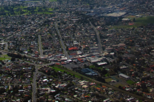 Взгляд на папатутоэ | |
 | |
| Координаты: 36 ° 58′47 ″ S 174 ° 51′04 ″ E / 36,979770 ° S 174,851224 ° E | |
| Страна | Новая Зеландия |
| Город | Окленд |
| Местная власть | Оклендский совет |
| Избирательное отделение | Хейкука, ват |
| Местный совет | Папоэто местный совет |
| Область | |
| • Земля | 1134 га (2802 акров) |
| Население (Июнь 2023 г.) [ 2 ] | |
| • Общий | 52,910 |
| Железнодорожные станции | Папатотоэк -вокзал Пехи железнодорожный вокзал |
| Мангер Восток | Midbfemore | Доля |
| (В направлении аэропорта Окленда ) |
|
Плоский куст |
| (К гавани Манукау ) | Манукау Центральный | Манукау Центральный |
Papatoetoe - пригород в Окленде , Новая Зеландия . Это самый большой пригород в Окленде по населению [ 3 ] и расположен к северо -западу от центра Манукау и в 18 километрах к юго -востоку от Окленда КБР .
Папатуто был традиционно важной областью для тамаки маори , который использовал портедж Вака между рекой Тамаки и ручьем Вамауаури, чтобы добраться до гавани Манукау , в качестве альтернативы Портажу Отахуху на севере. Район развивался как фермерское сообщество в 19 -м веке и значительно вырос в 1950 -х и 1960 -х годах после того, как была построена южная автомагистраль в Окленде . Papatoetoe в настоящее время известен своим значительным населением индийских новозеландцев .
Этимология
[ редактировать ]Папатотет означает «территория, где рост Toetoe », имея в виду виды трав австрарии , которые традиционно росли в этом районе. [ 4 ] [ 5 ] Название Papatoetoe впервые использовалось английскими поселенцами с 1850 -х годов. [ 6 ] Правописание PapatoItoi было распространено на английском языке в 19 веке и постепенно заменялось папатото после того, как местное почтовое отделение начало использовать это правописание. [ 7 ]
Геология
[ редактировать ]
Papatoetoe-это низменная плоская площадь на юге Окленда , расположенная к югу от Оклендского переуса и к востоку от полуострова Манджере . [ 5 ] Некоторые особенности вулканического поля Окленда можно найти вокруг Папатото, в том числе Кохуора , кольцо -туф, которое разразилось примерно 34 000 лет назад, [ 8 ] становясь водно -болотным угодьем после того, как кратер постепенно заполняется водой и осадком, [ 5 ] и Crater Hill , который разразился примерно 30 000 лет назад. [ 8 ] Низкие вулканические особенности Южного Окленда были коллективно известны под названием NGA Tapuwae Mataoho («Священные следы матахо ») для народов маори Тамаки , ссылаясь на божество, которое было вовлечено в их творение. [ 9 ] [ 10 ]
Papatoetoe-это плоская область между водосборами гавани Манукау на западе и рекой Тамаки на северо-востоке. Основными водными путями в этом районе включают ручей Ваукаури , ручей Пухинуи на юге, а также северо-текущая река Тамаки и ручей Атара .
Район был поддержан до оккупации человека, и к 1840 -м годам была покрыта смесью папоротника и скраба, в том числе растения, такие как канука , манука и Toetoe . [ 5 ]
История
[ редактировать ]История маори
[ редактировать ]
Первое свидетельство тамаки маори прибрежного в районе гавани манукау приходит с 14 -го века, что свидетельствует о первых поселениях позже в 15 -м веке. [ 11 ] Папатуто сформировал важную часть тренера / Коннелита Manukau Harbour , а The Порта также Окленд Порта и Окленд Порта и Окленд , контролируемые людьми, которые острова / гора Ричмонд . [ 12 ] Papatoetoe с традиционным регионом Ваги , который будет использовать современный Тайнуи / Вайохуа Те Киохуа . [ 13 ] Проведенная (пословица) определяет границы папатото:
"Хаумора, Запад, Окленд, чтобы загрузить, зима до середины"
« Кохуора на западе, берега реки Тамаки и головная платье на шаге посередине». [ 5 ]
По сравнению с другими частями Тамаки Макаурау ( Оклендский регион ), в Папатотее мало укрепленных участков Pā о плоской земле. В Кэдестер районе Папатоте, в районе Папатоте, в Кратер (Хиллсайд Южный парк). [ 6 ] Pā известен под названием Te pā-e-te-tū-tahi-atu, название, которое описывает Pā как временное, из-за окружающего плоского пейзажа, не идеального для укреплений. [ 14 ]
Портаж Waokauri / Pukaki был активно использован в раннюю колониальную эпоху до 1860 -х годов, как способ перевозки товаров в Papatoetoe. [ 6 ]
Colonial era
[edit]
In January 1836 missionary William Thomas Fairburn brokered a land sale between Tāmaki Māori chiefs, Pōtatau Te Wherowhero and Turia of Ngāti Te Rau, covering the majority of modern-day South Auckland between Ōtāhuhu and Papakura. The sale was envisioned as a way to end hostilities in the area, but it is unclear what the chiefs understood or consented to. Māori continued to live in South Auckland, unchanged by this sale.[15] Fairburn was criticised for the sheer size of the purchase, and in 1842 the Crown significantly reduced the size of his land holdings,[16] and the Crown partitioned much of the land for European settlers.[15]
In April 1851, the Tāmaki Bridge was constructed along the Great South Road, spurring growth in the Papatoetoe area.[6] In 1855 the road was metalled, and coach services to Auckland began in 1857 when the road reached as far south as Drury.[5] European settlers began settling in the area from the 1850s, primarily Scottish and Irish Presbyterians. The area was sparsely populated, featuring large country houses such as Hillside, Puhi Nui and Papahinu. The first St Johns Presbyterian Church was built in 1855 (later replaced by wooden Gothic and brick churches).[5] In 1861, Governor George Grey ordered the construction of the Great South Road further into the Waikato, to improve supply lines through swampy and thickly forested country, prior to the Invasion of the Waikato.[17] On 9 July 1863, due to fears of the Māori King Movement, Governor Grey proclaimed that all Māori living in the South Auckland area needed to swear loyalty to the Queen and give up their weapons. Most people refused due to strong links to Tainui, leaving for the south. During this time, the Te Ākitai Waiohua rangatira Īhaka Takaanini was arrested and died on Rakino Island.[18] After the war, the Crown confiscated 1.2 million acres of Māori land around the Waikato, including Waiohua land in South Auckland.[5]
The first local government in the area was the Papatoitoi Highway District, which was defined in 1865 and began meeting from in 1868.[5] In 1875, the Papatoetoe railway station opened, connecting Papatoetoe to Auckland in the north. The new township began developing around the railway station, and by the 1880s dairy farming had become popular in the area.[5]
Suburban growth
[edit]

Housing estates began developing in Papatoetoe in the early 1900s, primarily to the east of the railway station. These included the Kolmar Estate (1903), Central Estate (1912), the Ideal Estate (1913), Llanforda Estate (1913), Station Estate (1913), and the Green Park Estate (1914).[5] By 1911, the population of Papatoetoe had doubled to 400 people.[5] In March 1912, a temporary military camp was established for the 3rd (Auckland) Regiment at Puhinui.[5]
In 1918, a public hall was constructed for Papatoetoe, and in the following year growth in the area meant that Papatoetoe became a town district.[5] Papatoetoe became one of the fastest growing areas of Auckland in the 1920s, and a second commercial area began to develop in Papatoetoe, at the motor bus service terminus on Great South Road, near the Hunter's tearooms, which developed into Hunters Corner.[6] During the Great Depression, growth slowed in Papatoetoe, and the area became known for poultry farming.[5] In 1929, the Waitemata Brewery opened near Papatoetoe, operated by the Dominion Brewery.[5]
During World War II, the Cambria Park estate was requisitioned by the Public Works Department, who constructed a military camp for 6,000 troops from the United States Army. Middlemore Hospital opened in 1947, intended as a temporary military hospital, later becoming permanent.[5]
Papatoetoe grew large enough to become a borough in 1946.[5] In the late 1940s and early 1950s, the Māori Affairs Department of the New Zealand Government encouraged growth in the Papatoetoe area, leading to an influx of Urban Māori moving from rural areas of the country.[5]
The development of the Auckland Southern Motorway led to an explosion in the population of Papatoetoe, with the population increasing four times in the post-World War II period. The motorway opened between Ellerslie and Redoubt Road in 1955.[5] In 1958, the first modern supermarket in New Zealand was opened in Papatoetoe, by Tom Ah Chee, Norm Kent and John Brown,[6] and in 1962 Nestlé opened a factory at Cambria Park in Papatoetoe, becoming a major employer in the area.[5]
Papatoetoe became a city in 1965, and was amalgamated into Manukau City in 1989.[5] In 1991, the Hunters Plaza mall was opened.[6] Population growth had mostly ceased and remained stagnant throughout the 1990s and early 2000s, however a significant increase in population occurred after 2006 due to high rates of immigration and changes to the Auckland Unitary Plan allowing more intensive infill housing on large sections.[19] Papatoetoe has the unofficial title of Auckland's Little India, with 40 percent of the suburb's population being of Indian ethnicity according to the 2018 census.[20][21]
Local government
[edit]The first local government in the area was the Papatoitoi Highway District, which was defined in 1865. This was succeeded by the Papatoetoe Town Board in 1919.[5] In 1946, population growth led to Papatoetoe becoming a borough, and by 1965 Papatoetoe became a city. With the local government reforms of 1989, Papatoetoe was amalgamated into the Manukau City.[6] In November 2010, all cities and districts of the Auckland Region were amalgamated into a single body, governed by the Auckland Council.[22] The old Papatoetoe City Council building is at 91 Cambridge Terrace, Papatoetoe.
Papatoetoe is a part of the Ōtara-Papatoetoe local board, who elect members to the Ōtara-Papatoetoe Local Board, as well as two Manukau ward councillors who sit on the Auckland Council.
List of mayors
[edit]| Name | Term | |
|---|---|---|
| Papatoetoe Borough Council | ||
| 1 | Victor Maurice Tracey | 1946–1948 |
| 2 | Thomas Richard Smytheman | 1948–1953 |
| 3 | Cyril James Mahon | 1953–1959 |
| 4 | Lee Isbister Murdoch | 1959–1965 |
| Papatoetoe City Council | ||
| 5 | Bob White | 1965–1986 |
| 6 | Allan Walter Brewster | 1986–1989 |
Demographics
[edit]Papatoetoe covers 11.34 km2 (4.38 sq mi)[1] and had an estimated population of 52,910 as of June 2023,[2] with a population density of 4,666 people per km2.
| Year | Pop. | ±% p.a. |
|---|---|---|
| 2006 | 34,188 | — |
| 2013 | 38,238 | +1.61% |
| 2018 | 43,599 | +2.66% |
| Source: [23] | ||
Before the 2023 census, the suburb had a smaller boundary, covering 11.10 km2 (4.29 sq mi).[1] Using that boundary, Papatoetoe had a population of 43,599 at the 2018 New Zealand census, an increase of 5,361 people (14.0%) since the 2013 census, and an increase of 9,411 people (27.5%) since the 2006 census. There were 11,469 households, comprising 22,248 males and 21,354 females, giving a sex ratio of 1.04 males per female, with 9,288 people (21.3%) aged under 15 years, 12,051 (27.6%) aged 15 to 29, 18,405 (42.2%) aged 30 to 64, and 3,852 (8.8%) aged 65 or older.
Ethnicities were 19.8% European/Pākehā, 12.7% Māori, 29.1% Pacific peoples, 50.1% Asian, and 2.1% other ethnicities. People may identify with more than one ethnicity.
The percentage of people born overseas was 51.6, compared with 27.1% nationally.
Although some people chose not to answer the census's question about religious affiliation, 17.9% had no religion, 36.4% were Christian, 1.3% had Māori religious beliefs, 18.2% were Hindu, 6.4% were Muslim, 2.3% were Buddhist and 12.5% had other religions.
Of those at least 15 years old, 6,060 (17.7%) people had a bachelor's or higher degree, and 6,120 (17.8%) people had no formal qualifications. 2,910 people (8.5%) earned over $70,000 compared to 17.2% nationally. The employment status of those at least 15 was that 17,913 (52.2%) people were employed full-time, 4,278 (12.5%) were part-time, and 1,593 (4.6%) were unemployed.[23]
| Name | Area (km2) |
Population | Density (per km2) |
Households | Median age | Median income |
|---|---|---|---|---|---|---|
| Grange | 1.43 | 2,187 | 1,529 | 462 | 26.8 years | $22,100[24] |
| Papatoetoe North | 0.99 | 4,779 | 4,827 | 1,320 | 30.2 years | $30,200[25] |
| Dingwall | 0.83 | 3,408 | 4,106 | 900 | 31.3 years | $30,900[26] |
| Aorere South | 1.24 | 4,944 | 3,987 | 1,155 | 28.8 years | $27,800[27] |
| Papatoetoe West | 1.22 | 4,755 | 3,898 | 1,233 | 29.3 years | $30,300[28] |
| Papatoetoe Central | 1.46 | 5,085 | 3,483 | 1,545 | 33.3 years | $28,000[29] |
| Papatoetoe East | 1.07 | 4,362 | 4,077 | 1,125 | 30.5 years | $27,000[30] |
| Papatoetoe South West | 0.83 | 3,729 | 4,493 | 906 | 29.1 years | $28,100[31] |
| Papatoetoe South | 0.80 | 3,972 | 4,965 | 1,122 | 32.0 years | $27,700[32] |
| Puhinui North | 0.70 | 3,852 | 5,503 | 1,083 | 31.8 years | $30,300[33] |
| Puhinui South | 0.53 | 2,526 | 4,766 | 618 | 30.1 years | $29,000[34] |
| New Zealand | 37.4 years | $31,800 |
Economy
[edit]
Papatoetoe Town Centre
[edit]In early 2009 planning began to revitalise the town centre in the St. George Street area. The plan envisaged new apartment buildings and nearby sports facilities bringing more business to the area, which had struggled due to competition from shopping malls.[35]
Hunter's Corner
[edit]Hunter's Corner has become a popular shopping area for shoppers of Indian origin. Hunter's Corner accounts for 60 retail outlets of which about 40 have some form of Indian flavour.[20]
Hunter's Corner used to be a notorious area for prostitution in the early 2000s due to it being relatively safer compared to similar town centres in South Auckland, however prostitution has largely disappeared in recent times after strong opposition from local residents.[36]
Hunters Plaza
[edit]The Hunters Plaza shopping mall opened in 1991 and was upgraded in 2015.[37] It features 47 stores, including Kmart and Countdown.[38]
Transport
[edit]Papatoetoe contains two train stations within the suburban limits. These include the Papatoetoe railway station situated in Old Papatoetoe and nearby Puhinui railway station situated in Puhinui Road. Both the Eastern Line and the Southern Line services both train stations. During peak times there is a train approximately every 5 minutes heading towards Britomart. It takes approximately 30 minutes from Papatoetoe railway station into Britomart. The Puhinui Station Interchange was upgraded in July 2021 to provide a rapid transit network to Auckland Airport, as well as forming a connection with Manukau. It takes approximately 10–12 minutes from Puhinui Station to Auckland Airport.[39][40]
Auckland Southern Motorway and Southwestern Motorway connect Papatoetoe with Auckland City and Manukau. Southwestern Motorway interchanges are on Puhinui Road to the south and Massey Road in Māngere East to the north. The Southern Motorway interchange is on East Tamaki Road.
Sports
[edit]Association football
[edit]Papatoetoe is home to Papatoetoe AFC who compete in the Lotto Sport Italia NRFL Division 1A. Papatoetoe is home to Papatoetoe United who play from the sports complex on Great South Road and are affiliated with Auckland Football Federation.
Cricket
[edit]Papatoetoe is home to the Papatoetoe Cricket Club who play in the Auckland Cricket Championship.
Rugby league
[edit]Papatoetoe is home to the Papatoetoe Panthers who are affiliated with the Auckland Rugby League.
Rugby union
[edit]Papatoetoe Rugby Football Club was established in 1946 and plays home matches at the Papatoetoe Sport Complex on Great South Road.
Tennis
[edit]Papatoetoe is home to two tennis clubs, Papatoetoe Tennis Club located at Papatoetoe Sports Complex and Sunnyside Tennis Club located in the Sunnyside Domain. Both clubs are affiliated to Auckland Tennis. Sunnyside Tennis Club was formed originally as Puhunui Tennis Club in 1955.
Education
[edit]Primary education
[edit]Papatoetoe has five primary schools in its zone:
- Holy Cross School is a Catholic full primary school (years 1–8) integrated with the state system. Founded in 1953, it has a roll of 570.[41]
- Papatoetoe Central School is a state contributing primary school (years 1–6) with a roll of 826. Founded in 1857, the school moved to its current site in 1872.[42][43]
- Papatoetoe East School is a state contributing primary school (years 1–6). It was established in 1958 and currently has a roll of 582.[44]
- Papatoetoe South School is a state contributing primary school (years 1–6). It has a roll of 585.[45]
- Papatoetoe West School is a state contributing primary school (years 1–6) which opened in 1949. It has a roll of 722.[46]
In addition, Papatoetoe North School, Puhinui School and South Auckland Seventh-day Adventist School could be considered to be in Papatoetoe.
Papatoetoe has one intermediate school:
- Papatoetoe Intermediate School is a state school for years 7–8 with a roll of 787.[47]
Kedgley Intermediate is on the boundary of the Papatoetoe area.
Secondary education
[edit]Papatoetoe has two secondary schools:
- Papatoetoe High School.is a state secondary school (years 9–13) with a roll of 1675.[48]
- Aorere College.is a state secondary school (years 9–13) with a roll of 1647.[49]
All these schools are coeducational. Rolls are as of August 2024.[50]
Papatoetoe Historical Society
[edit]Papatoetoe Historical Society was established in 1988 with the aim to gather the historical artifacts and information from the Papatoetoe district. The collection held includes a collation of information on Local Body members, schools as they developed, the origin and meaning of street names, women of the district (book available), people of the surrounding farming district, newspaper cuttings and information on local organisations. The society has also developed an archive collection which includes photographs, books, booklets, plans and posters. These collections can be viewed at the Papatoetoe Historical Society museum, currently being set up at the Papatoetoe Chambers, 35 St George St, Papatoetoe following its relocation from The Depot .[51][52]
In 2012, Papatoetoe celebrated 150 years of civic life. The Papatoetoe 150 was initiated by the Papatoetoe Historical society to increase awareness of history and promote community organisations.
Notable people
[edit]- Douglas Al-Bazi, refugee from Iraq
- Len Brown - Former Mayor of Auckland
- Barry Crump – Author, poet
- David Dallas – Hip Hop Artist
- Dillon Boucher - NZ Basketball Player, lived in Papatoetoe and went to Papatoetoe High School
- Ricki Herbert – Soccer player – Played National Level for the All Whites and is their current coach. Also played for New Zealand in Soccer World Cup Finals 1982
- Phil Goff – Mayor of Auckland, Former Labour Party Leader, Foreign and Defence Minister, lived in Papatoetoe and attended Papatoetoe High School
- Mike King - Mental Health Advocate[53]
- Kyle Jamieson - NZ Cricketer, lived in Papatoetoe [54]
- Keven Mealamu - Former All Black. Lived in Papatoetoe and attended Aorere College
- Trevor Meale – Cricketer
- David Shearer - Former Labour Party Leader, lived in Papatoetoe and attended Papatoetoe High School
- Ish Sodhi - NZ Cricketer, lived in Papatoetoe and attended Papatoetoe High School
- Tyree Tautogia – Part of highly successful rap group Smashproof[55]
- Gary Troup – Played club cricket in Papatoetoe going on to represent New Zealand 1976 – 1986
- Heather Matthews (née Thompson) – Silver Medalist 1978 Commonwealth Games (3000 m). MBE – Services To Sport, Papatoetoe Sports Person of the Year.
- Dei Hamo - Musician, attended Aorere College, referenced Papatoe in his top charting track We Gon' Ride.[56]
Attractions
[edit]
- Murals in Old Papatoetoe
- "Picnic Scene" by Ron van Dam (near Wallace Road corner)
- "Papatoetoe General Store" by Christine Trout (Papatoetoe Mall)
- "Bottle O" by Christine Trout (Papatoetoe Mall)
- "Cameos" by Claudia Pond-Eyley (near Town Hall)
- "Old Papatoetoe Logo" by Ron van Dam (near Shirley Road)
- "St George St – 1930" by Merv Appleton (Rangitoto Road)
- Historical cemeteries at Manukau Memorial Gardens and St John's Presbyterian Church.
- Historic landmarks including
- Old Railway Station
- Cambria House and associated historic gardens (Puhinui Road)
- Old Children's home (now in Wyllie Road)
References
[edit]- ^ Jump up to: a b c "ArcGIS Web Application". statsnz.maps.arcgis.com. Retrieved 25 April 2024.
- ^ Jump up to: a b "Population estimate tables - NZ.Stat". Statistics New Zealand. Retrieved 25 October 2023.
- ^ "2018 Census place summaries | Stats NZ".
- ^ Our Auckland (18 May 2021). "Māori names and stories showcased in local parks". Auckland Council. Retrieved 28 April 2023.
- ^ Jump up to: a b c d e f g h i j k l m n o p q r s t u v w Auckland Council Heritage Unit (2014). "Papatoetoe Historic Heritage Survey: Survey Report" (PDF). Auckland Council. Retrieved 28 April 2023.
- ^ Jump up to: a b c d e f g h "Papatoetoe Heritage Trail" (PDF). Ōtara-Papatoetoe Local Board. 2013. Retrieved 31 March 2023.
- ^ "1 April 1897". Manukau's Journey. Auckland Libraries Heritage Collections. MJ_1386. Retrieved 27 April 2023.
- ^ Jump up to: a b Hopkins, Jenni L.; Smid, Elaine R.; Eccles, Jennifer D.; Hayes, Josh L.; Hayward, Bruce W.; McGee, Lucy E.; van Wijk, Kasper; Wilson, Thomas M.; Cronin, Shane J.; Leonard, Graham S.; Lindsay, Jan M.; Németh, Karoly; Smith, Ian E. M. (3 July 2021). "Auckland Volcanic Field magmatism, volcanism, and hazard: a review". New Zealand Journal of Geology and Geophysics. 64 (2–3): 213–234. doi:10.1080/00288306.2020.1736102. hdl:2292/51323. S2CID 216443777.
- ^ "The History of Our Marae". Makaurau Marae. Retrieved 1 September 2021.
- ^ Simmons, D. R. (1979). "George Graham's Maori Place Names of Auckland". Records of the Auckland Institute and Museum. 16: 11–39. ISSN 0067-0464. JSTOR 42906272. Wikidata Q58677091.
- ^ Mackintosh 2021, pp. 28.
- ^ "Papatoetoe street names". Auckland Libraries. Retrieved 16 May 2022.
- ^ Gibb, Russell (1 September 2015). "Archaeological Assessment of Self Farm / Crater Hill, Papatoetoe, Auckland". Geometria Limited. Retrieved 16 May 2022.
- ^ "Pā o Tahi / Hillside South Park". Auckland Council. Retrieved 28 April 2023.
- ^ Jump up to: a b Moore, D; Rigby, B; Russell, M (July 1997). Rangahaua Whanui National Theme A: Old Land Claims (PDF) (Report). Waitangi Tribunal. Retrieved 5 March 2023.
- ^ Wichman, Gwen 1990, pp. 3.
- ^ O'Malley, Vincent (6 December 2016). "'The great war for NZ broke out less than 50 km from Queen St': Vincent O'Malley on the Waikato War and the making of Auckland". The Spinoff. Retrieved 30 March 2023.
- ^ Mackintosh 2021, pp. 100–101, 107.
- ^ "Statistical area 1 dataset for 2018 Census – updated March 2020 | Stats NZ".
- ^ Jump up to: a b Bakshi, Kanwaljit Singh (14 August 2019). "Papatoetoe in South Auckland emerges as Little India". indiannewslink.co.nz. Retrieved 3 March 2021.
- ^ «Этническая группа (подробный общий ответ - Уровень 3) по возрасту и полу, для переписи, как правило, жителей населения, 2006, 2013 и переписи 2018 года (RC, TA, SA2, DHB)» . nzdotstat.stats.govt.nz . Получено 3 марта 2021 года .
- ^ Блейкли, Роджер (2015). «Структура планирования для Окленда« Супер Сити »: взгляд инсайдера» . Политика ежеквартально . 11 (4). doi : 10.26686/pq.v11i4.4572 . ISSN 2324-1101 .
- ^ Jump up to: а беременный «Статистическая область 1 набор данных для переписи 2018 года» . Статистика Новая Зеландия. Март 2020 года. Грандж (153000), Север Пафете (154000), Dingwall (154800), Paphetoe East (155800), Papatoetoe South (156200), север (156500) и Puenui South (156700).
- ^ 2018 Перепись Сводка: Grange
- ^ Резюме переписного участка 2018 года: папатуто -север
- ^ 2018 Перепись Сводка: Dingwall
- ^ Резюме переписного участка 2018 года: Aorere South
- ^ 2018 Площадь Перепись.
- ^ 2018 Площадь Перепись Сводка: Papatoetoe Central
- ^ Резюме переписного участка 2018 года: Папатоте -Восток
- ^ Резюме переписного участка 2018 года: Папатутоу Юго -Запад
- ^ Резюме переписного участка 2018 года: Papatoetoe South
- ^ Резюме переписного участка 2018 года: север щенка
- ^ 2018 Перепись Сводка: Pule South
- ^ Подтяжка лица, чтобы помочь центру города сражаться с торговыми центрами - New Zealand Herald , среда, 25 марта 2009 г., страница A8
- ^ Томпсон, Уэйн (31 августа 2005 г.). «Жители сплотились против угловой сексуальной торговли охотниками» . NZ Herald . Получено 1 февраля 2019 года .
- ^ «Hunters Plaza завершает обновление» . Kiwi Media Publishing. Индийский недельный.
- ^ «Hunters Plaza наши магазины» . Huntersplaza.co.nz . Побережье.
- ^ Ли, выше (24 июля 2021 года). «Оклендский транспортный центр в Окленде открылся » Новозеландское телевидение.
- ^ «Обмен на станцию Puhinui: автобусная и железнодорожный центр папатотетоэ на 69 млн. Долл. США приближаются к завершению» . Вещи/Fairfax. 17 июня 2021 года.
- ^ Образование Подсчета: Школа Святого Креста (Папатутоэ)
- ^ Подсчет образования: Центральная школа Papatoetoe
- ^ "Общая информация" . Папатотет -центральная школа . Получено 30 августа 2020 года .
- ^ Подсчет образования: Papatoetoe East School
- ^ Подсчет образования: South School Papatoetoe
- ^ Подсчет образования: школа Papatoetoe West School
- ^ Подсчет образования: папатуто -промежуточный
- ^ Подсчет образования: средняя школа Papatoetoe
- ^ Подсчет образования: колледж Aorere
- ^ «Справочник новозеландских школ» . Министерство образования Новой Зеландии . Получено 17 сентября 2024 года .
- ^ «Историческое общество Папатуто» . Новозеландские исторические общества.
- ^ «Историческое общество Папатоте в музеях Новой Зеландии» . nzmuseums.co.nz . Те папа .
- ^ «Вакцина вакцины с коронавирусом 19: комик Майк Кинг взрывает диких самодовольных« фанатов в дебатах » - NZ Herald» .
- ^ «История Кайла Джеймисона: от стрельбы по обручам до скальпирования звезд» . Индийский экспресс . 21 февраля 2020 года.
- ^ Хьюз, Эндрю (октябрь - ноябрь 2006 г.). «Функция: Тайри - сейчас или никогда» . NZ Musician Magazine . 13 (2). Архивировано из оригинала 22 мая 2010 года . Получено 27 октября 2009 года .
- ^ «Мы не поехали» . Гениальность Получено 3 декабря 2022 года .
Библиография
[ редактировать ]- Макинтош, Люси (2021). Сдвигающие основания: глубокие истории Тамаки Макаурау Окленд . Бриджит Уильямс книги . doi : 10.7810/9781988587332 . ISBN 978-1-988587-33-2 .
- Wichman, Gwen (1990). Парящая птица: история Манурева до 1965 года . Manurewa: Историческое общество Manurewa (опубликовано 2001). ISBN 0-473-07114-2 .
- Kalous, Milan (1984). Небольшой город в Новой Зеландии . Публичная библиотека Манукау: городской совет Папатуто.