Список первичных государственных автомагистралей в Вирджинии короче одной мили
Ниже приведен список первичных государственных автомагистралей в Вирджинии меньше одной мили (1,6 км). Список таких автомагистралей, обслуживающих государственные учреждения штата Вирджиния, см. Государственные автомагистрали, обслуживающие государственные учреждения штата Вирджиния .
SR 34
[ редактировать ] Государственный маршрут 34 | ||||
|---|---|---|---|---|
| Информация о маршруте | ||||
| Поддерживается VDOT | ||||
| Длина | 0,54 миль [ 1 ] (870 м) | |||
| Расположение | ||||
| Страна | Соединенные Штаты | |||
| Состояние | Вирджиния | |||
| Шоссе | ||||
| ||||

State Route 34 является обозначением для Ходжес -стрит, которая проходит 0,54 мили (870 м) от SR 129 восточного до США 360 в городе Южный Бостон . [ 1 ] [ 2 ]
SR 73
[ редактировать ] Государственный маршрут 73 | ||||
|---|---|---|---|---|
| Информация о маршруте | ||||
| Поддерживается VDOT | ||||
| Длина | 0,78 миль [ 1 ] (1260 м) | |||
| Расположение | ||||
| Страна | Соединенные Штаты | |||
| Состояние | Вирджиния | |||
| Шоссе | ||||
| ||||

Государственный маршрут 73 является обозначением части Пархам-роуд между США 1 и I-95 возле района Чемберлейна в Хенрико . Parham Road-это четырехполосное шоссе, которое проходит вдоль запада и северной стороны Ричмонда от SR 150 возле реки Джеймс до нас 301 к югу от I-295 . [ 1 ] [ 3 ] SR 73 был запланирован и построен как простая труба между I-95 и США 1; Номер был назначен в 1958 году. [ 4 ] Дорога была завершена в 1962 году; Расширение Parham Road на восток от I-95 открылось в 1978 году. [ 5 ]
SR 79
[ редактировать ] Государственный маршрут 79 | ||||
|---|---|---|---|---|
| Информация о маршруте | ||||
| Поддерживается VDOT | ||||
| Длина | 0,23 миль [ 1 ] (370 м) | |||
| Расположение | ||||
| Страна | Соединенные Штаты | |||
| Состояние | Вирджиния | |||
| Шоссе | ||||
| ||||

State Route 79 -это обозначение для Apple Mountain Road, 0,23-мильного (370 м) разъема между SR 55 и алмазной развязкой с I-66 в Линдене . [ 1 ] [ 6 ]
SR 93
[ редактировать ] Государственный маршрут 93 | ||||
|---|---|---|---|---|
| Информация о маршруте | ||||
| Поддерживается VDOT | ||||
| Длина | 0,92 миль [ 1 ] (1480 м) | |||
| Расположение | ||||
| Страна | Соединенные Штаты | |||
| Состояние | Вирджиния | |||
| Шоссе | ||||
| ||||

Государственный маршрут 93 является обозначением для части 0,92-мильной (1480 м) части шоссе Уилсон между США 58 возле устья Уилсона и государственной линии штата Северная Каролина . Государственное шоссе пересекает Новую реку к югу от США 58 и продолжается на юге как шоссе Северной Каролины 93 . [ 1 ] [ 7 ]
SR 98
[ редактировать ] State Route 98 | ||||
|---|---|---|---|---|
| Route information | ||||
| Maintained by VDOT | ||||
| Length | 0.50 mi[1] (800 m) | |||
| Location | ||||
| Country | United States | |||
| State | Virginia | |||
| Highway system | ||||
| ||||

State Route 98 является обозначением для части 0,50 мили (800 м) на главной улице к югу от США 52 и SR 42 в Bland . Главная улица продолжается на юге как SR 605 . [ 1 ] [ 8 ]
SR 109
[ редактировать ] State Route 109 | ||||
|---|---|---|---|---|
| Route information | ||||
| Maintained by VDOT | ||||
| Length | 0.91 mi[1] (1,460 m) | |||
| Location | ||||
| Country | United States | |||
| State | Virginia | |||
| Highway system | ||||
| ||||

Государственный маршрут 109 -это обозначение Hickory Hill Road, которая проходит 0,91 мили (1460 м) от США от 460 востока до экстракса в форт Грегг-Адамс в городе Петербург . [ 1 ] [ 9 ]
SR 112
[ редактировать ] State Route 112 | ||||
|---|---|---|---|---|
| Route information | ||||
| Maintained by VDOT | ||||
| Length | 0.65 mi[1] (1,050 m) | |||
| Location | ||||
| Country | United States | |||
| State | Virginia | |||
| Highway system | ||||
| ||||

Государственный маршрут 112 -это обозначение для секции 0,65 миль (1050 м) на Wildwood Road от US 11 и US 460 в городе Салем -север до Скайвью-роуд к северу от четырехполосного обмена шоссе с I-81 к северу от севера Городские ограничения в округе Роанок . [ 1 ] [ 10 ]
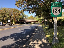
SR 124
[ редактировать ] State Route 124 | ||||
|---|---|---|---|---|
| Route information | ||||
| Maintained by VDOT and NPS | ||||
| Length | 0.87 mi[1][11] (1,400 m) | |||
| Location | ||||
| Country | United States | |||
| State | Virginia | |||
| Highway system | ||||
| ||||
State Route 124 -это обозначение для сегмента штата Run Bran с 0,17 миль (900 футов; 270 м), поддержанный государством, между США 29 и Лорком-лейн в Арлингтоне . Шоссе продолжается на юге как Кирквуд -роуд до района Вирджинии на площади Арлингтона. Spout Run Parkway продолжается на восток как шоссе Службы национальных парков , параллельно одноименному притоку реки Потомак с частичным развязкой с Мемориальным парком Джорджа Вашингтона . [ 1 ] [ 11 ]
- Основные перекрестки
Весь маршрут находится в округе Арлингтон .
| Расположение | мне [ 1 ] [ 11 ] | км | Направления | Примечания | |
|---|---|---|---|---|---|
| Вудмонт | 0.00 | 0.00 | Западный термин | ||
| Мэйвуд | 0.17 | 0.27 | Лорком Лейн | Переход от состояния к обслуживанию NPS | |
| Росслин | 0.87 | 1.40 | Джордж Вашингтон Parkway South - Key Bridge , Вашингтон | Обмен; Восточный термин | |
| 1000 миль = 1,609 км; 1000 км = 0,621 миль | |||||
SR 132Y
[ редактировать ] State Route 132Y | ||||
|---|---|---|---|---|
| Route information | ||||
| Maintained by VDOT | ||||
| Length | 0.29 mi[1] (470 m) | |||
| Location | ||||
| Country | United States | |||
| State | Virginia | |||
| Highway system | ||||
| ||||

State Route 132y -это 0,29-мильная (470 м) шпора в Вильямсбурге . Он начинается на направленном пересечении с SR 132 к западу от Колониального Центра посетителей Уильямсбурга . Оттуда он продолжается до конца на другом направленном пересечении с колониальным бульваром . [ 1 ] [ 12 ]
SR 140
[ редактировать ] State Route 140 | ||||
|---|---|---|---|---|
| Route information | ||||
| Maintained by VDOT | ||||
| Length | 0.38 mi[1] (610 m) | |||
| Existed | 1960–present | |||
| Location | ||||
| Country | United States | |||
| State | Virginia | |||
| Highway system | ||||
| ||||

State Route 140 является обозначением для сегмента штата, поддержанного в 0,38 мили (610 м), от I-81 с севера до США 11 / США 19 в Абингдоне . [ 1 ] [ 13 ] SR 140 был добавлен в государственную систему шоссе в 1960 году как связь между межгосударственными и американскими автомагистралями. [ 14 ]
SR 146
[ редактировать ] State Route 146 | ||||
|---|---|---|---|---|
| Route information | ||||
| Maintained by VDOT | ||||
| Length | 0.86 mi[1] (1,380 m) | |||
| Location | ||||
| Country | United States | |||
| State | Virginia | |||
| Highway system | ||||
| ||||

State Route 146 является обозначением для автострады 0,86 мили (1380 м) между SR 76 (Powhite Parkway) в направлении округа Честерфилд и SR 195 (Downtown Spressway) в направлении центра города Ричмонд в городе Ричмонд . Автострада составляет юго-восточную сторону Wye между SR 76, SR 195 и I-195 к западу от центра Ричмонда. SR 146 имеет обмен с Maplewood Avenue рядом со стадионом City . [1][15]
SR 148
[edit] State Route 148 | ||||
|---|---|---|---|---|
| Route information | ||||
| Maintained by VDOT | ||||
| Length | 0.87 mi[1] (1,400 m) | |||
| Location | ||||
| Country | United States | |||
| State | Virginia | |||
| Highway system | ||||
| ||||

State Route 148 is the designation for the 0.87-mile (1,400 m) section of Chances Creek Road from I-77 east to US 52 near Fancy Gap. Via US 52, SR 148 connects I-77 with the Blue Ridge Parkway. The parkway has an interchange with US 52 in the hamlet of Fancy Gap, also the name of the mountain pass where US 52 summits the Blue Ridge Mountains.[1][16]
SR 162
[edit] State Route 162 | ||||
|---|---|---|---|---|
| Route information | ||||
| Maintained by VDOT | ||||
| Length | 0.17 mi[1] (270 m) | |||
| Location | ||||
| Country | United States | |||
| State | Virginia | |||
| Highway system | ||||
| ||||

State Route 162 is the designation for the 0.17-mile (900 ft; 270 m) section of Second Street between the east city limit of Williamsburg and SR 143 in York County.[1][17]
SR 167
[edit] State Route 167 | ||||
|---|---|---|---|---|
| Информация о маршруте | ||||
| Поддерживается VDOT | ||||
| Расположение | ||||
| Страна | Соединенные Штаты | |||
| Состояние | Вирджиния | |||
| Шоссе | ||||
| ||||

Virginia State Route 167 (SR 167) is a state highway in Botetourt County, Virginia, in the United States. Known as Gateway Crossing, the road was completed in December 2016 as part of a project to ease congestion around the intersection of Interstate 81 (I-81), U.S. Route 220 Alternate (US 220 Alt.) and US 11 in southern Botetourt County.[18]
SR 181
[edit] Государственный маршрут 181 | ||||
|---|---|---|---|---|
| Информация о маршруте | ||||
| Поддерживается VDOT | ||||
| Длина | 0,95 миль [ 1 ] (1530 м) | |||
| Расположение | ||||
| Страна | Соединенные Штаты | |||
| Состояние | Вирджиния | |||
| Шоссе | ||||
| ||||

State Route 181 is the designation for portions of Main Street and King Street in and near Belle Haven, Accomack County. The state highway begins at an indeterminate point in the town; the highway continues north as SR 609. Just north of Main Street's intersection with SR 178, which heads west as Shields Bridge Road and south as Belle Haven Road, SR 181 turns east onto King Street, which the highway follows to its eastern terminus at US 13.[1][19]
SR 188
[edit] Государственный маршрут 188 | ||||
|---|---|---|---|---|
| Информация о маршруте | ||||
| Поддерживается VDOT | ||||
| Длина | 0,91 миль [ 1 ] (1460 м) | |||
| Расположение | ||||
| Страна | Соединенные Штаты | |||
| Состояние | Вирджиния | |||
| Шоссе | ||||
| ||||

State Route 188 runs 0.91 miles (1,460 m) through the city streets of Clifton Forge. The state highway begins at the intersection of westbound Main Street and eastbound Ridgeway Street, a one-way pair that carries US 60 Business and US 220 Business in the downtown area. SR 188 heads west on Main Street and turns north onto McCormick Boulevard. McCormick Boulevard is one-way northbound until Church Street; southbound SR 188 follows Church Street east and Commercial Street south to Main Street. SR 188 continues north on McCormick Boulevard to Lafayette Street, which the state highway follows one block west. The state highway turns north on Rose Avenue, west on Tremont Street, and north on Sioux Avenue to its northern terminus just south of the road's underpass of I-64, US 60, and US 220.[1][20]
SR 196
[edit] Государственный маршрут 196 | ||||
|---|---|---|---|---|
| Информация о маршруте | ||||
| Поддерживается VDOT | ||||
| Длина | 0,96 миль [ 1 ] (1540 м) | |||
| Расположение | ||||
| Страна | Соединенные Штаты | |||
| Состояние | Вирджиния | |||
| Шоссе | ||||
| ||||

State Route 196 is the designation for the 0.96-mile (1,540 m) portion of Canal Drive from Military Highway, which carries US 13 and US 460, north to US 17 near the Deep Creek area of the city of Chesapeake.[1][21]
SR 209
[edit] Государственный маршрут 209 | ||||
|---|---|---|---|---|
| Информация о маршруте | ||||
| Поддерживается VDOT | ||||
| Длина | 0,88 миль [ 1 ] (1420 м) | |||
| Расположение | ||||
| Страна | Соединенные Штаты | |||
| Состояние | Вирджиния | |||
| Шоссе | ||||
| ||||

State Route 209 (SR 209) is the mostly unsigned designation for Innovation Avenue, which from 1990 to 2015 ran 0.88 miles (1,420 m) from an intersection with SR 28 (originally a signalized intersection, then from 2007 to 2015 a right-in/right-out interchange with northbound SR 28) east to the Center for Innovative Technology (CIT) on the eastern edge of Loudoun County near Herndon.[1][22] At the east end of SR 209, at the line between Loudoun and Fairfax Counties, Innovation Avenue continued east and north as SR 847 to SR 605 (Rock Hill Road). In Fall 2011, construction began on expansion of the SR 28 interchange to a full interchange.[23] In January 2016, the entire route (including the SR 28 interchange) was closed in order to complete the full trumpet interchange and to realign the entire highway to access the CIT on its north side, instead of the south. The project was completed in early 2017.[24][25]
SR 212
[edit] Государственный маршрут 212 | ||||
|---|---|---|---|---|
| Информация о маршруте | ||||
| Поддерживается VDOT | ||||
| Длина | 0,87 миль [ 1 ] (1400 м) | |||
| Расположение | ||||
| Страна | Соединенные Штаты | |||
| Состояние | Вирджиния | |||
| Шоссе | ||||
| ||||

State Route 212 is the designation for Chatham Heights Road, which runs 0.87 miles (1,400 m) from SR 3 Business north to SR 218 in the community of Chatham Heights just east of Fredericksburg.[1][26] The entire route is part of U.S. Bicycle Route 1.
SR 233
[edit] Государственный маршрут 233 | ||||
|---|---|---|---|---|
| Информация о маршруте | ||||
| Поддерживается VDOT | ||||
| Длина | 0,36 миль [ 1 ] (580 м) | |||
| Расположение | ||||
| Страна | Соединенные Штаты | |||
| Состояние | Вирджиния | |||
| Шоссе | ||||
| ||||

State Route 233 is the designation for the Airport Viaduct, a 0.36-mile (580 m) highway that runs east from a trumpet interchange with US 1 east to an entrance to Ronald Reagan Washington National Airport in the Crystal City section of Arlington. The state highway is entirely elevated from US 1 to its eastern terminus between CSX's RF&P Subdivision and the George Washington Memorial Parkway.[1][27]
Major intersections
[edit]The entire route is in Arlington County. All exits are unnumbered.
| Location | mi[1][27] | km | Destinations | Notes | |
|---|---|---|---|---|---|
| Crystal City | 0.00 | 0.00 | Trumpet interchange; western terminus | ||
| 0.10 | 0.16 | Crystal Drive | Westbound exit only | ||
| Reagan National Airport | 0.36 | 0.58 | George Washington Parkway south | Eastbound entrance only | |
| 0.36 | 0.58 | Eastern terminus; access roads continue east | |||
| 1.000 mi = 1.609 km; 1.000 km = 0.621 mi | |||||
SR 246
[edit] Государственный маршрут 246 | ||||
|---|---|---|---|---|
| Информация о маршруте | ||||
| Поддерживается VDOT | ||||
| Длина | 0,76 миль [ 1 ] (1220 м) | |||
| Расположение | ||||
| Страна | Соединенные Штаты | |||
| Состояние | Вирджиния | |||
| Шоссе | ||||
| ||||
State Route 246 is the designation for a 0.76-mile (1,220 m) section of Liberty Street in the South Norfolk section of the city of Chesapeake. The state highway starts at Poindexter Street, which carries US 460 and SR 166 south from the intersection; the two other highways head west on Liberty Street before turning north onto 22nd Street. SR 246's eastern terminus is at Campostella Road at the road's junction with SR 168.[1][28]
SR 270
[edit] Государственный маршрут 270 | ||||
|---|---|---|---|---|
| Информация о маршруте | ||||
| Поддерживается VDOT | ||||
| Длина | 0,26 миль [ 1 ] (420 м) | |||
| Расположение | ||||
| Страна | Соединенные Штаты | |||
| Состояние | Вирджиния | |||
| Шоссе | ||||
| ||||

State Route 270 is the designation for the 0.26-mile (420 m) portion of 4th Street between US 58 Alternate and SR 63 in the town of St. Paul.[1][29]
SR 283
[edit] Государственный маршрут 283 | ||||
|---|---|---|---|---|
| Информация о маршруте | ||||
| Поддерживается VDOT | ||||
| Длина | 0,36 миль [ 1 ] (580 м) | |||
| Расположение | ||||
| Страна | Соединенные Штаты | |||
| Состояние | Вирджиния | |||
| Шоссе | ||||
| ||||

State Route 283 is the designation for a 0.36-mile (580 m) portion of the Trail of the Lonesome Pine in the city of Norton. The state highway begins at Park Avenue, which heads west and north as US 23 Business and US 58 Alternate Business. SR 283's eastern terminus is at an interchange with US 23 and US 58 Alternate. The entire road is also part of U.S. Route 58 Alternate Business.[1][30]
SR 290
[edit] Государственный маршрут 290 | ||||
|---|---|---|---|---|
| Информация о маршруте | ||||
| Поддерживается VDOT | ||||
| Длина | 0,61 миль [ 1 ] (980 м) | |||
| Расположение | ||||
| Страна | Соединенные Штаты | |||
| Состояние | Вирджиния | |||
| Шоссе | ||||
| ||||

State Route 290 is the designation for College Street in the town of Dayton. The state highway, which has a length of 0.61 miles (980 m) between the east and north town limits of Dayton, also follows a small piece of Huffman Drive and has a short concurrency with SR 42 Business.[1][31]
SR 292
[edit] Государственный маршрут 292 | ||||
|---|---|---|---|---|
| Информация о маршруте | ||||
| Поддерживается VDOT | ||||
| Длина | 0,39 миль [ 1 ] (630 м) | |||
| Расположение | ||||
| Страна | Соединенные Штаты | |||
| Состояние | Вирджиния | |||
| Шоссе | ||||
| ||||

State Route 292 is the designation for Conicville Road, a 0.39-mile (630 m) connector between I-81 and US 11 in Mount Jackson.[1][32]
SR 296
[edit] Государственный маршрут 296 | ||||
|---|---|---|---|---|
| Информация о маршруте | ||||
| Поддерживается VDOT | ||||
| Длина | 0,39 миль [ 1 ] (630 м) | |||
| Расположение | ||||
| Страна | Соединенные Штаты | |||
| Состояние | Вирджиния | |||
| Шоссе | ||||
| ||||

State Route 296 is the designation for the cumulative 0.39-mile (630 m) portions of Kirby Street and 10th Street from SR 30 and SR 33 (14th Street) south and east to SR 298 (Lee Street) in the town of West Point.[1][33]
SR 298
[edit] Государственный маршрут 298 | ||||
|---|---|---|---|---|
| Информация о маршруте | ||||
| Поддерживается VDOT | ||||
| Длина | 0,75 миль [ 1 ] (1210 м) | |||
| Расположение | ||||
| Страна | Соединенные Штаты | |||
| Состояние | Вирджиния | |||
| Шоссе | ||||
| ||||

State Route 298 is the designation for the cumulative 0.75-mile (1,210 m) portions of 5th Street and Lee Street from a dead end at the Pamunkey River east and north to SR 33 (14th Street) in the town of West Point.[1][34]
SR 299
[edit] Государственный маршрут 299 | ||||
|---|---|---|---|---|
| Информация о маршруте | ||||
| Поддерживается VDOT | ||||
| Длина | 0,79 миль [ 1 ] (1270 м) | |||
| Расположение | ||||
| Страна | Соединенные Штаты | |||
| Состояние | Вирджиния | |||
| Шоссе | ||||
| ||||

State Route 299 is the designation for the 0.79-mile (1,270 m) section of Madison Road between US 15 and US 29 southwest of the town of Culpeper. Madison Road continues east into the town as US 29 Business.[1][35]
SR 300
[edit] Государственный маршрут 300 | ||||
|---|---|---|---|---|
| Информация о маршруте | ||||
| Поддерживается VDOT | ||||
| Длина | 0,64 миль [ 1 ] (1030 м) | |||
| Расположение | ||||
| Страна | Соединенные Штаты | |||
| Состояние | Вирджиния | |||
| Шоссе | ||||
| ||||

State Route 300 is a 0.64-mile (1,030 m) state highway in Powhatan. The state highway begins at SR 13 next to the Powhatan County courthouse. SR 300 heads east on Courthouse Tavern Lane, turns south onto Tilman Road, then turns east onto Scottsville Road to its eastern terminus at US 60.[1][36] A wye route of SR 300, SR 300Y, runs 0.04 miles (210 ft; 64 m) along Tilman Road from Marion Harland Lane north to Scottsville Road on the southeast side of the courthouse property.[1][37]
SR 304
[edit] Государственный маршрут 304 | ||||
|---|---|---|---|---|
| Информация о маршруте | ||||
| Поддерживается VDOT | ||||
| Длина | 0,71 миль [ 1 ] (1140 м) | |||
| Расположение | ||||
| Страна | Соединенные Штаты | |||
| Состояние | Вирджиния | |||
| Шоссе | ||||
| ||||

State Route 304 is the designation for Seymour Drive, which runs 0.71 miles (1,140 m) from US 501 east to US 360 north of and parallel to the Dan River within the town of South Boston.[1][38]
SR 306
[edit] Государственный маршрут 306 | ||||
|---|---|---|---|---|
| Информация о маршруте | ||||
| Поддерживается VDOT | ||||
| Длина | 0,88 миль [ 1 ] (1420 м) | |||
| Расположение | ||||
| Страна | Соединенные Штаты | |||
| Состояние | Вирджиния | |||
| Шоссе | ||||
| ||||
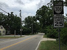
State Route 306 is the designation for the 0.88-mile (1,420 m) segment of Harpersville Road from US 60 east to US 17 and SR 143 within the city of Newport News.[1][39]
SR 349
[edit] Государственный маршрут 349 | ||||
|---|---|---|---|---|
| Информация о маршруте | ||||
| Поддерживается VDOT | ||||
| Длина | 0,12 миль [ 1 ] (190 м) | |||
| Расположение | ||||
| Страна | Соединенные Штаты | |||
| Состояние | Вирджиния | |||
| Шоссе | ||||
| ||||

State Route 349 is the designation for Edmunds Boulevard, a 0.12-mile (630 ft; 190 m) L-shaped highway that passes closely follows the west and south sides of the Halifax County Courthouse in the town of Halifax. The north and east sides of the courthouse are flanked by SR 360 and US 501, respectively.[1][40]
SR 359
[edit] Государственный маршрут 359 | ||||
|---|---|---|---|---|
| Информация о маршруте | ||||
| Поддерживается VDOT | ||||
| Длина | 0,34 миль [ 1 ] (550 м) | |||
| Турист маршруты | ||||
| Расположение | ||||
| Страна | Соединенные Штаты | |||
| Состояние | Вирджиния | |||
| Шоссе | ||||
| ||||

State Route 359 is the designation for Jamestown Festival Parkway, a 0.34-mile (550 m) connector between Colonial Parkway and SR 31 near the site of the Jamestown settlement.[1][41] The road was taken over by the state in 1959.[42]
SR 380
[edit] Государственный маршрут 380 | ||||
|---|---|---|---|---|
| Информация о маршруте | ||||
| Поддерживается VDOT | ||||
| Длина | 0,8 мили [ 43 ] (1300 м) | |||
| Расположение | ||||
| Страна | Соединенные Штаты | |||
| Состояние | Вирджиния | |||
| Шоссе | ||||
| ||||

State Route 380 is the designation for Elko Tract Road, a 0.34-mile-long (550 m) connector between Technology Boulevard and SR 156 in eastern Henrico County near Sandston.[43][44] The route runs on the site of the Elko Tract, a former ghost town and World War II decoy city now being converted to an industrial park.
SR 404
[edit] Государственный маршрут 404 | ||||
|---|---|---|---|---|
| Информация о маршруте | ||||
| Поддерживается VDOT | ||||
| Длина | 0,53 миль [ 1 ] (850 м) | |||
| Расположение | ||||
| Страна | Соединенные Штаты | |||
| Состояние | Вирджиния | |||
| Шоссе | ||||
| ||||

State Route 404 is the designation for the 0.53-mile (850 m) segment of Princess Anne Road between SR 168 (Tidewater Drive) and SR 166 (Park Avenue) near the downtown area of Norfolk. Princess Anne Road continues west as a city street through the Ghent neighborhood and east as SR 166.[1][45]
SR 405
[edit] Государственный маршрут 405 | ||||
|---|---|---|---|---|
| Информация о маршруте | ||||
| Поддерживается VDOT | ||||
| Длина | 0,64 миль [ 1 ] (1030 м) | |||
| Расположение | ||||
| Страна | Соединенные Штаты | |||
| Состояние | Вирджиния | |||
| Шоссе | ||||
| ||||

State Route 405 is the designation for the 0.64-mile (1,030 m) segment of Ballentine Boulevard between I-264 and US 58 east of the downtown area of Norfolk.[1][46]
SR 409
[edit] Государственный маршрут 409 | ||||
|---|---|---|---|---|
| Информация о маршруте | ||||
| Поддерживается VDOT | ||||
| Длина | 0,2 мили [ 1 ] (320 м) | |||
| Расположение | ||||
| Страна | Соединенные Штаты | |||
| Состояние | Вирджиния | |||
| Округа | Новый округ Кент | |||
| Шоссе | ||||
| ||||

State Route 409 is the designation for the 0.2-mile (320 m) segment of G.W. King Boulevard from US 60 Pocahontas Trail to Eastern Region, Virginia Forestry Service near Providence Forge in New Kent County.[1][47]
References
[edit]- ^ Jump up to: a b c d e f g h i j k l m n o p q r s t u v w x y z aa ab ac ad ae af ag ah ai aj ak al am an ao ap aq ar as at au av aw ax ay az ba bb bc bd be bf bg bh bi bj bk bl bm bn bo bp bq br bs bt bu "2010 Traffic Data". Virginia Department of Transportation. 2010. Archived from the original on December 3, 2011. Retrieved December 24, 2011.
- Accomack County (PDF)
- Alleghany County and City of Covington (PDF)
- Округ Арлингтон и город Александрия (PDF)
- Бланковый округ (PDF)
- Округ Кэрролл и город Галакс (PDF)
- Округ Калпепер (PDF)
- Округ Динвидди и город Петербург (PDF)
- Округ Грейсон (PDF)
- Округ Галифакс (PDF)
- Округ Хенрико (PDFRDDD)
- Округ Джеймс Сити и город Уильямсбург (PDF)
- Король Уильям округ (PDF)
- Округ Лоудоун (PDF)
- Город Норфолк, город Портсмут и город Чесапик (PDF)
- Округ Паухатан (PDF)
- Роанок округ, город Роанок и город Салем (PDF)
- Округ Рокингем и город Харрисонбург (PDF)
- Округ Шенандоа (PDF)
- Стаффорд округ (PDF)
- Округ Уоррен (PDF)
- Город Ньюпорт Новости (PDF)
- Округ Вашингтон и город Бристоль (PDF)
- Мудрый округ и город Нортон (PDF)
- Округ Йорк и город Покосон (PDF)
- ^ «Маршрут 34 штата Вирджиния» (карта). Карты Google . Получено 28 июня 2011 года .
- ^ «Маршрут 73 штата Вирджиния» (карта). Карты Google . Получено 18 июня 2011 года .
- ^ Государственная комиссия по шоссе Вирджинии (28 августа 1958 г.). «Протокол встречи» (PDF) (отчет). Ричмонд: Содружество Вирджинии. п. 64
- ^ Национальный инвентарь моста
- ^ «Маршрут штата Вирджиния 79» (Карта). Карты Google . Получено 9 июня 2011 года .
- ^ «Маршрут штата Вирджиния 93» (Карта). Карты Google . Получено 18 июня 2011 года .
- ^ «Маршрут штата Вирджиния 98» (Карта). Карты Google . Получено 18 июня 2011 года .
- ^ «Маршрут штата Вирджиния 109» (Карта). Карты Google . Получено 28 июня 2011 года .
- ^ «Маршрут штата Вирджиния 112» (Карта). Карты Google . Получено 30 июня 2011 года .
- ^ Jump up to: а беременный в «Государственный маршрут 124» (карта). Карты Google . Получено 8 октября 2016 года .
- ^ «Маршрут штата Вирджиния 132y» (Карта). Карты Google . Получено 2 ноября 2011 года .
- ^ «Маршрут штата Вирджиния 140» (Карта). Карты Google . Получено 24 декабря 2011 года .
- ^ Государственная комиссия по шоссе Вирджинии (18 августа 1960 г.). «Протокол встречи» (PDF) (отчет). Ричмонд: Содружество Вирджинии. п. 36
- ^ «Маршрут штата Вирджиния 146» (Карта). Карты Google . Получено 18 июня 2011 года .
- ^ «Маршрут штата Вирджиния 148» (Карта). Карты Google . Получено 18 июня 2011 года .
- ^ «Маршрут штата Вирджиния 162» (Карта). Карты Google . Получено 18 июня 2011 года .
- ^ Уорд, Джен (12 декабря 2016 г.). «Открытие New Connector Road, чтобы предшествовать крупному обходу на выходе 150 от I-81 18 декабря» (пресс-релиз). Департамент транспорта Вирджинии . SAL 50 . Получено 7 июня 2018 года .
- ^ «Маршрут штата Вирджиния 181» (Карта). Карты Google . Получено 15 июня 2011 года .
- ^ «Маршрут штата Вирджиния 188» (Карта). Карты Google . Получено 18 июня 2011 года .
- ^ «Маршрут штата Вирджиния 196» (Карта). Карты Google . Получено 15 июня 2011 года .
- ^ «Маршрут штата Вирджиния 209» (Карта). Карты Google . Получено 18 июня 2011 года .
- ^ «Обмен возле Даллеса все еще работа в процессе» . The Washington Post . 13 мая 2014 года.
- ^ «Инновационные проспекты 2 и 3» . Маршрут 28 государственное/частное партнерство . Получено 10 января 2016 года .
- ^ "Обновление трафика" . Усовершенствование коридора маршрута 28 . Маршрут 28 государственное/частное партнерство . Получено 10 января 2016 года .
- ^ «Маршрут штата Вирджиния 212» (Карта). Карты Google . Получено 30 июня 2011 года .
- ^ Jump up to: а беременный «Государственный маршрут 233» (карта). Карты Google . Получено 8 октября 2016 года .
- ^ «Маршрут штата Вирджиния 246» (Карта). Карты Google . Получено 15 июня 2011 года .
- ^ «Маршрут штата Вирджиния 270» (Карта). Карты Google . Получено 30 июня 2011 года .
- ^ «Маршрут штата Вирджиния 283» (Карта). Карты Google . Получено 30 июня 2011 года .
- ^ «Маршрут штата Вирджиния 290» (Карта). Карты Google . Получено 30 июня 2011 года .
- ^ «Маршрут штата Вирджиния 292» (Карта). Карты Google . Получено 30 июня 2011 года .
- ^ «Маршрут штата Вирджиния 296» (Карта). Карты Google . Получено 15 июня 2011 года .
- ^ «Маршрут штата Вирджиния 298» (Карта). Карты Google . Получено 15 июня 2011 года .
- ^ «Маршрут штата Вирджиния 299» (Карта). Карты Google . Получено 18 июня 2011 года .
- ^ «Маршрут штата Вирджиния 300» (Карта). Карты Google . Получено 28 июня 2011 года .
- ^ «Маршрут 300y штата Вирджиния» (карта). Карты Google . Получено 28 июня 2011 года .
- ^ «Маршрут штата Вирджиния 304» (Карта). Карты Google . Получено 28 июня 2011 года .
- ^ «Маршрут штата Вирджиния 306» (Карта). Карты Google . Получено 30 июня 2011 года .
- ^ «Маршрут штата Вирджиния 349» (Карта). Карты Google . Получено 28 июня 2011 года .
- ^ «Маршрут штата Вирджиния 359» (Карта). Карты Google . Получено 18 июня 2011 года .
- ^ Государственная комиссия по шоссе Вирджинии (8 января 1959 г.). «Протокол встречи» (PDF) (отчет). Ричмонд: Содружество Вирджинии. п. 19
- ^ Jump up to: а беременный «Маршрут штата Вирджиния 380» (Карта). Карты Google . Получено 24 мая 2014 года .
- ^ «Информационная карта онлайн -транспорта» . Департамент транспорта Вирджинии . Получено 24 мая 2014 года .
- ^ «Маршрут штата Вирджиния 404» (Карта). Карты Google . Получено 12 июня 2011 года .
- ^ «Маршрут штата Вирджиния 405» (Карта). Карты Google . Получено 12 июня 2011 года .
- ^ «Маршрут штата Вирджиния 409» (Карта). Карты Google . Получено 18 сентября 2014 года .