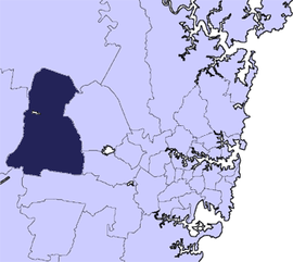
Город Пенрит

| Город Пенрит Новый Южный Уэльс | |||||||||||||||
|---|---|---|---|---|---|---|---|---|---|---|---|---|---|---|---|
 Место в столичном Сиднее | |||||||||||||||
| Координаты | 33 ° 45 'с 150 ° 42′E / 33,750 ° S 150,700 ° E | ||||||||||||||
| Население | 217 664 ( перепись 2021 года ) [ 1 ] ( 24 -е ) | ||||||||||||||
| • Density | 537.57/km2 (1,392.31/sq mi) | ||||||||||||||
| Established | 12 May 1871 (Municipality) 21 October 1959 (City) | ||||||||||||||
| Area | 404.9 km2 (156.3 sq mi) | ||||||||||||||
| Time zone | AEST (UTC+10) | ||||||||||||||
| • Summer (DST) | AEDT (UTC+11) | ||||||||||||||
| Mayor | Todd Carney | ||||||||||||||
| Council seat | Civic Centre, Penrith | ||||||||||||||
| Region | Greater Western Sydney | ||||||||||||||
| State electorate(s) | |||||||||||||||
| Federal division(s) | |||||||||||||||
| Website | City of Penrith | ||||||||||||||
| |||||||||||||||
Город Пенрит - это район местного самоуправления в штате Новый Южный Уэльс , Австралия . Места города расположено в Пенрите , расположенном в Сиднее, примерно в 50 километрах (31 миль) к западу от Центрального делового района Сиднея . Он занимает часть традиционных земель Даруга народа. Впервые включенная в качестве муниципалитета 12 мая 1871 года, 1 января 1949 года, муниципалитеты Пенрита, Сент -Мэри и Каслри и часть Nepean Shire объединились, чтобы сформировать новый муниципалитет Пенрита. Пенрит был объявлен городом 21 октября 1959 года и расширился на запад, включил в себя равнины Emu и Emu Heights, ранее часть города Голубых гор , 25 октября 1963 года. По состоянию на перепись 2021 года в городе Пенрит около 217 664 Полем [ 1 ]
Мэр лейбористской города Пенрит - Тодд Карни, член партии. [ 2 ]
Suburbs and localities in the local government area
[ редактировать ]The following suburbs and localities are located within the City of Penrith:
- Agnes Banks (shared with the City of Hawkesbury)
- Badgerys Creek (shared with the City of Liverpool)
- Berkshire Park
- Caddens
- Cambridge Gardens
- Cambridge Park
- Castlereagh
- Claremont Meadows
- Colyton
- Cranebrook
- Emu Heights
- Emu Plains
- Erskine Park
- Glenmore Park
- Jamisontown
- Jordan Springs
- Kemps Creek (shared with Liverpool)
- Kingswood
- Leonay
- Llandilo
- Londonderry
- Luddenham (shared with Liverpool)
- Mount Vernon
- Mulgoa
- North St Marys
- Orchard Hills
- Oxley Park
- Penrith
- Regentville
- St Clair
- St Marys (shared with City of Blacktown)
- Shanes Park (shared with City of Blacktown)
- South Penrith
- Wallacia (shared with Liverpool and Wollondilly Shire)
- Werrington
- Werrington County
- Werrington Downs
Council history
[edit]

The Municipality of Penrith was incorporated on 12 May 1871 under the Municipalities Act 1858 (NSW). On 3 March 1890, St Marys was separately incorporated, and on 26 July 1893 and 9 September 1895, Mulgoa and Castlereagh followed respectively. In 1913, Mulgoa became the "A" Riding of the neighbouring Nepean Shire.[3]
On 1 January 1949, under the Local Government (Areas) Act 1948, the Municipalities of Penrith, St Marys and Castlereagh and A Riding of the Nepean Shire amalgamated to form a new Municipality of Penrith. It was declared a City on 21 October 1959, and expanded westwards to include Emu Plains and Emu Heights, formerly part of the City of Blue Mountains, on 25 October 1963.[3]
Demographics
[edit]At the 2021 census, there were 217,644 people in the Penrith local government area, of these 49.4% were male and 50.6% were female. Aboriginal and Torres Strait Islander people made up 5% of the population; notably above the national average of 3.4%. The median age of people in the City of Penrith was 35 years; notably below the national median of 39 years. Children aged 0 – 14 years made up 21.2% of the population and people aged 65 years and over made up 12.9% of the population. Of people in the area aged 15 years and over, 45.5% were married and 12.3% were either divorced or separated.[4]
Population growth in the City of Penrith between the 2001 Census and the 2006 census was 0.15% and in the subsequent five years to the 2011 census, population growth was 3.68%. When compared with total population growth of Australia for the same periods, being 5.78% and 8.32% respectively, population growth in the Penrith local government area was significantly lower than the national average.[5] The median weekly income for residents within the City of Penrith was on with par with the national average.[4]
At the 2021 census, the proportion of residents in the Penrith local government area who stated their ancestry as Australian or Anglo-Saxon exceeded 63.5% of all residents (national average was 58.4%). In excess of 28.7% of all residents in the City of Penrith area nominated a religious affiliation with Christianity at the 2021 census, which was fairly higher than the national average of 20%. Meanwhile, as at the Census date, compared to the national average, households in the Penrith local government area had a marginally lower than average proportion (23.9%) where two or more languages are spoken (national average was 24.8%); and a higher proportion (74.2%) where English only was spoken at home (national average was 72%).[4]
| Selected historical census data for Penrith local government area | |||||||
|---|---|---|---|---|---|---|---|
| Census year | 2001[5] | 2006[6] | 2011[4] | 2016[7] | 2021 | ||
| Population | Estimated residents on census night | 171,870 | 172,140 | 178,467 | 196,066 | 217,644 | |
| LGA rank in terms of size within New South Wales | 7th | 13th | 9th | ||||
| % of New South Wales population | 2.58% | 2.63% | 2.67% | ||||
| % of Australian population | 0.92% | 0.84% | 0.85% | ||||
| Cultural and language diversity | |||||||
| Ancestry, top responses |
Australian | 29.1% | 26.3% | 33.3% | |||
| English | 25.2% | 24.5% | 30.2% | ||||
| Irish | 6.8% | 7.2% | 8.2% | ||||
| Scottish | 5.3% | 5.5% | 6.7% | ||||
| Maltese | 3.0% | 2.8% | |||||
| Language, top responses (other than English) |
Arabic | 1.3% | 1.6% | 1.8% | |||
| Tagalog | 1.3% | 1.1% | 1.2% | ||||
| Italian | 1.0% | 0.9% | |||||
| Maltese | 0.8% | 0.7% | |||||
| Hindi | 0.6% | 0.9% | 1.1% | ||||
| Religious affiliation | |||||||
| Religious affiliation, top responses |
Catholic | 34.5% | 32.1% | 28.7% | |||
| Anglican | 26.1% | 18.4% | 13.1% | ||||
| No religion | 9.8% | 21.1% | 28.9% | ||||
| Presbyterian and Reformed | 3.4% | ||||||
| Uniting Church | 3.7% | ||||||
| Median weekly incomes | |||||||
| Personal income | Median weekly personal income | A$517 | A$623 | A$728 | A$866 | ||
| % of Australian median income | 110.9% | 108.0% | 109.6% | 106.52% | |||
| Family income | Median weekly family income | A$1,147 | A$1,582 | A$1,858 | A$2188 | ||
| % of Australian median income | 111.7% | 106.8% | 107.1% | 100.14% | |||
| Household income | Median weekly household income | A$1,285 | A$1,398 | A$1,658 | A$1903 | ||
| % of Australian median income | 109.7% | 113.3% | 111.5% | 104.05% | |||
Council
[edit]
Composition and election methods
[edit]| Term | Aldermen/Councillors | Wards | Mayor |
|---|---|---|---|
| 1871–1891 | 9 | No wards | Annual election by Aldermen |
| 1891–1893 | 12 | ||
| 1893–1948 | 9 | ||
| 1949–1950 | 24 | Ward One (9, Penrith) Ward Two (9, St Marys) Ward Three (3, Nepean) Ward Four (3, Castlereagh) | |
| 1950–1959 | 12 (3 per ward) | Ward One Ward Two Ward Three Ward Four | |
| 1959–1963 | 13 (3 per ward: 12 Aldermen, 1 Mayor) | Direct triennial election | |
| 1963–1968 | 13 (4 per ward: 12 Aldermen, 1 Mayor) | North Ward South Ward East Ward | |
| 1968–1987 | 12 (4 per ward) | Annual election by Aldermen/Councillors | |
| 1987–date | 15 (5 per ward) |
Current composition and election method
[edit]
Penrith City Council is composed of fifteen councillors elected proportionally as three separate wards, each electing five councillors. All councillors are elected for a fixed four-year term of office. The mayor is elected by the councillors at the first meeting of the council for a two-year term, while the deputy mayor is elected for a single-year term only. The most recent election was held on 4 December 2021. The current council is as follows:[8][9][10]

| Party | Councillors | |
|---|---|---|
| Australian Labor Party | 4 | |
| Liberal Party of Australia | 6 | |
| Independents | 4 | |
| Vacant Seats | 1 | |
| Total | 15 | |
The current Council, elected in 2021, in order of election by ward, is:
| Ward | Councillor | Party | Notes | |
|---|---|---|---|---|
| East Ward[8] | Bernard Bratusa | Liberal | ||
| Tricia Hitchen | Liberal | Mayor 2022-2023;[11] Deputy Mayor 2016–2017, 2020–2021[12] | ||
| Todd Carney | Labor | Mayor 2023–Present; Deputy Mayor 2022–2023 | ||
| Marlene Shipley | Independent | |||
| Robin Cook | Labor | |||
| North Ward[9] | John Thain | Labor | Mayor 2005–2006, 2016–2018; Deputy Mayor 2004–2005[12] | |
| Ross Fowler OAM | Liberal | Mayor 1995–1996, 2013–2015, 2018–2020; Deputy Mayor 2015–2016 | ||
| Glenn Gardiner | Liberal | |||
| Jonathan Pullen | Independent | Member of the Multicultural Working Party and the Recreation Working Party. Was a member of the Labor Party until 2022.[13] | ||
| Kevin Crameri OAM | Independent | Mayor 1996–1997, 2009–2011; Deputy Mayor 1988–1989. | ||
| South Ward[10] | Karen McKeown OAM | Labor | Mayor 2015–2016, 2020–2021; Deputy Mayor 2006–2007, 2019–2020[14] | |
| Mark Davies | Liberal | Mayor 2012–2013; Deputy Mayor 2023–Present | ||
| Mark Rusev | Labor | |||
| Sue Day | Independent | |||
| Jim Aitken OAM | Resigned[15] | Mayor 2008–2009; Deputy Mayor 2010–2011, 2013–2014. Resigned 2023. | ||
Election results
[edit]2024
[edit]| Party | Votes | % | Swing | Seats | Change | ||
|---|---|---|---|---|---|---|---|
| Labor | |||||||
| Liberal | |||||||
| Greens | |||||||
| Libertarian | |||||||
| Independents | |||||||
| Formal votes | |||||||
| Informal votes | |||||||
| Total | 15 | ||||||
| Registered voters / turnout | |||||||
2021
[edit]The election was conducted by the Australian Election Company.[16]
| Party | Votes | % | Swing | Seats | Change | ||
|---|---|---|---|---|---|---|---|
| Labor | 36,376 | 34.5 | –6.2 | 5 | |||
| Liberal | 35,081 | 33.3 | +2.9 | 6 | |||
| Independent | 10,336 | 9.8 | |||||
| Sue Day Independent | 6,859 | 6.5 | 1 | ||||
| The North Ward Independents | 5,820 | 5.5 | 1 | ||||
| MARCUS CORNISH | 3,868 | 3.7 | |||||
| WE DESERVE BETTER | 3,073 | 2.9 | 1 | ||||
| Australia First | 2,549 | 2.4 | +2.4 | ||||
| People Before Politics | 1,534 | 1.5 | |||||
| Formal votes | 105,496 | ||||||
Mayors
[edit]| Mayor | Party | Term | Notes | |
|---|---|---|---|---|
| Patros Athanas Tornaros | Labor | 1 January 1949 – 5 December 1949 | [17] | |
| Bill Chapman | Independent | 5 December 1949 – 11 December 1956 | [18] | |
| Bernard Noel Fowler | Independent | 11 December 1956 – 11 December 1957 | [19] | |
| Leo Joseph Spies | Labor | 11 December 1957 – 19 April 1961 | [20][21][22][23][24][25] | |
| Bill Chapman | Independent | 3 June 1961 – December 1968 | [26][27] | |
| Ron Mulock | Labor | December 1968 – September 1971 | [28] | |
| Brian King | Independent | September 1971 – September 1974 | [28] | |
| Eileen Cammack OBE | Independent | September 1974 – September 1977 | [29] | |
| Brian King AM | Independent | September 1977 – September 1985 | [28] | |
| Kevin Dwyer OAM | Independent | September 1985 – September 1987 | [28] | |
| Rodney Field | Independent | September 1987 – September 1988 | [28] | |
| Kevin Dwyer OAM | Independent | September 1988 – September 1989 | [28] | |
| Brian King AM | Independent | September 1989 – September 1990 | [28][30] | |
| Faye Lo Po' AM | Labor | September 1990 – September 1991 | [28] | |
| Tony Aquilina | September 1991 – September 1992 | [28] | ||
| Bill Gayed | Independent | September 1992 – September 1993 | [28] | |
| Diane Beamer | Labor | September 1993 – September 1994 | [28] | |
| Pat Sheehy | September 1994 – September 1995 | [28] | ||
| Ross Fowler | Independent | September 1995 – September 1996 | [28] | |
| Kevin Crameri OAM | Independent | September 1996 – September 1997 | [28] | |
| Kevin Dwyer OAM | Independent | September 1997 – September 1998 | [28][31] | |
| John Bateman OAM | Independent | September 1998 – September 2000 | [28] | |
| David Bradbury | Labor | September 2000 – September 2001 | [28] | |
| Pat Sheehy | September 2001 – September 2002 | [28] | ||
| Greg Davies | September 2002 – April 2004 | [28] | ||
| David Bradbury | April 2004 – September 2004 | [28] | ||
| Jackie Greenow | Independent | September 2004 – September 2005 | [28] | |
| John Thain | Labor | September 2005 – September 2006 | [28] | |
| Pat Sheehy AM | September 2006 – September 2007 | [28][32] | ||
| Greg Davies | September 2007 – September 2008 | [28] | ||
| Jim Aitken OAM | Independent | September 2008 – September 2009 | [28][33] | |
| Kevin Crameri OAM | Independent | September 2009 – September 2011 | [28][34][35] | |
| Greg Davies | Labor | September 2011 – September 2012 | [28] | |
| Mark Davies | Liberal | September 2012 – 23 September 2013 | [28] | |
| Ross Fowler OAM | 23 September 2013 – September 2015 | [36][37] | ||
| Karen McKeown OAM | Labor | September 2015 – 26 September 2016 | [28] | |
| John Thain | 26 September 2016 – 24 September 2018 | [12] | ||
| Ross Fowler OAM | Liberal | 24 September 2018 – 28 September 2020 | [38] | |
| Karen McKeown OAM | Labor | 28 September 2020 – 13 January 2022 | [2] | |
| Tricia Hitchen | Liberal | 13 January 2022 – October 2023 | [39] | |
| Todd Carney | Labor | October 2023 – present | ||
Media
[edit]The City of Penrith is served by a weekly newspaper, The Western Weekender, which was founded in 1991. It produces a print edition each Friday as well as a digital news service. The newspaper is independently owned.
Sister cities
[edit]Since it signed its first agreement with Fujieda, Japan in 1984, Penrith City has gradually expanded its sister cities and international links programme. Presently Penrith has links with:
 Penrith, Cumbria, England – Sister City
 Fujieda City, Shizuoka Prefecture, Japan – Sister City
- Hakusan City (incorporating Matto City), Ishikawa Prefecture, Japan – Friendship City
 Kunshan, Jiangsu Province, China – Friendship City
- Xicheng District of Beijing City, China – Mutual Co-operation Agreement
 Gangseo-gu, Seoul, Republic of Korea – Mutual Co-operation Agreement
Heritage listings
[edit]The City of Penrith has a number of heritage-listed sites, including:
- Agnes Banks, Rickards Avenue: Agnes Bank Natural Area[40]
- Castlereagh, Castlereagh Road: Upper Castlereagh Public School[41]
- Emu Plains, Main Western railway: Emu Plains railway station[42]
- Londonderry, 947-953 Londonderry Road: Fossil and Petrology collections, New South Wales[43][44]
- Mulgoa, Fairlight Road: Fairlight Homestead[45]
- Mulgoa, Mulgoa Road: Fernhill, Mulgoa[46]
- Mulgoa, 754-760 Mulgoa Road: Glenmore, Mulgoa[47]
- Mulgoa, St Thomas Road: St Thomas' Anglican Church, Mulgoa[48]
- Mulgoa, 2 St Thomas Road: Cox's Cottage[49]
- Penrith, 34-40 Borec Road: Craithes House[50]
- Penrith, 26 Coombes Drive: Torin Building[51]
- Penrith, Great Western railway: Penrith railway station, Sydney[52]
- Penrith, Nepean River, Great Western Highway: Victoria Bridge (Penrith)[53]
- Penrith, Off Bruce Neale Dr, Steel Trusses 1.3 km past station: Emu Plains Underbridge[54]
- Penrith, 1 Museum Drive: Penrith Museum of Fire,[55] including the following:
- Fire and Rescue NSW Heritage Fleet[56]
- NSW Fire Brigades No 10 Vehicle Number Plates[57]
- 1869 Shand Mason 7 inch Manual Fire Engine[58]
- 1891 Shand Mason Fire Engine[59]
- 1898 Shand Mason Curricle Ladders[60]
- 1909 Edward Smith Headquarters Switchboard[61]
- 1929 Ahrens Fox PS2 Fire Engine[62]
- 1939 Dennis Big 6 Fire Engine[63]
- 1942 Ford 21W Fire Brigade Mobile Canteen[64]
- Regentville, 427 Mulgoa Road: Glenleigh Estate[65]
- St Marys, Great Western Railway: St Marys railway station, Sydney[66]
- St Marys, Mamre Road: Mamre, St Marys[67]
- Werrington, Water Street: Rose Cottage and Early Slab Hut[68]
References
[edit]- ^ Jump up to: a b Australian Bureau of Statistics (28 June 2022). "Penrith (C)". 2021 Census QuickStats. Retrieved 5 July 2017.
- ^ Jump up to: a b City Council, Penrith. "History made as new Council appoints Mayor, Deputy Mayor| Penrith City Council". Retrieved 14 January 2022.
- ^ Jump up to: a b "History of Local Government development in the Penrith and Surrounding Districts". Penrith City Council. 25 May 2009. Archived from the original on 22 June 2014. Retrieved 12 November 2009.
- ^ Jump up to: a b c d Australian Bureau of Statistics (31 October 2012). "Penrith (C)". 2011 Census QuickStats. Retrieved 8 December 2012.
- ^ Jump up to: a b Australian Bureau of Statistics (9 March 2006). "Penrith (C)". 2001 Census QuickStats. Retrieved 8 December 2012.
- ^ Australian Bureau of Statistics (25 October 2007). "Penrith (C)". 2006 Census QuickStats. Retrieved 8 December 2012.
- ^ Australian Bureau of Statistics (27 June 2017). "Penrith (C)". 2016 Census QuickStats. Retrieved 5 July 2017.
- ^ Jump up to: a b "Penrith City Council Election Night Results East Ward". Local Government Elections 2021. Australian Election Company. 17 December 2021. Retrieved 15 August 2023.
- ^ Jump up to: a b "Penrith City Council Election Night Results North Ward". Local Government Elections 2021. Australian Election Company. 17 December 2021. Retrieved 15 August 2023.
- ^ Jump up to: a b "Penrith City Council Election Night Results South Ward". Local Government Elections 2021. Australian Election Company. 17 December 2021. Retrieved 15 August 2023.
- ^ "Penrith Mayor Tricia Hitchen revealed her priorities as history is made". The Daily Telegraph. News Corp. 18 January 2022. Retrieved 14 August 2023.
- ^ Jump up to: a b c Georgopoulos, Marissa (28 September 2016). "Councillors John Thain and Tricia Hitchen to lead as mayor and deputy mayor". Penrith Press. Retrieved 1 June 2018.
- ^ Feszczuk, Emily (27 June 2022). "Council bombshell: Jonathan Pullen quits Labor". The Western Weekender. Retrieved 15 August 2023.
- ^ Higgins, Alena (24 September 2019). "Karen McKeown to take over as Penrith's Deputy Mayor". The Western Weekender. Retrieved 29 September 2019.
- ^ Dodds, Troy (20 July 2023). "Veteran Penrith City Councillor Jim Aitken formally resigns". The Western Weekender. Retrieved 15 August 2023.
- ^ Jump up to: a b "Penrith". ABC News.
- ^ "First Meeting of United Penrith Council". Nepean Times. Vol. 66, no. 4681. New South Wales, Australia. 23 December 1948. p. 1. Retrieved 2 June 2018 – via National Library of Australia.
- ^ "Ald. Chapman, Mayor of Penrith". Nepean Times. Vol. 67, no. 4729. New South Wales, Australia. 8 December 1949. p. 1. Retrieved 2 June 2018 – via National Library of Australia.
- ^ "Ald. B. Fowler Elected Mayor of Penrith". Nepean Times. Vol. 72, no. 5081. New South Wales, Australia. 13 December 1956. p. 1. Retrieved 2 June 2018 – via National Library of Australia.
- ^ "Ald. L. Spies Now Mayor of Penrith". Nepean Times. Vol. 75, no. 3891. New South Wales, Australia. 12 December 1957. p. 1. Retrieved 2 June 2018 – via National Library of Australia.
- ^ "Re-elected: Ald. Spies as Mayor, Ald. Thomas Deputy Mayor of Penrith". Nepean Times. Vol. 76, no. 3942. New South Wales, Australia. 18 December 1958. p. 1. Retrieved 2 June 2018 – via National Library of Australia.
- ^ "The Mayor". Nepean Times. Vol. 77, no. 3991. New South Wales, Australia. 10 December 1959. p. 1. Retrieved 2 June 2018 – via National Library of Australia.
- ^ "Penrith Plan: May How Remove All Uncertainty in Minds of Public of Penrith: The Mayor". Nepean Times. Vol. 78, no. 4004. New South Wales, Australia. 24 March 1960. p. 1. Retrieved 2 June 2018 – via National Library of Australia.
- ^ "Citizens Mourn Mayor: Many Tributes". Nepean Times. Vol. 79, no. 4032. New South Wales, Australia. 27 April 1961. p. 1. Retrieved 2 June 2018 – via National Library of Australia.
- ^ "Mayor's Successor". Nepean Times. Vol. 79, no. 4032. New South Wales, Australia. 27 April 1961. p. 1. Retrieved 2 June 2018 – via National Library of Australia.
- ^ "Mayor Quick off the Mark Starting Duties". Nepean Times. Vol. 79, no. 4038. New South Wales, Australia. 8 June 1961. p. 1. Retrieved 2 June 2018 – via National Library of Australia.
- ^ "Congratulations for New Mayor". Nepean Times. Vol. 79, no. 4038. New South Wales, Australia. 8 June 1961. p. 1. Retrieved 2 June 2018 – via National Library of Australia.
- ^ Jump up to: a b c d e f g h i j k l m n o p q r s t u v w x y z aa ab ac "Mayors – Penrith City Council". Local government history. Penrith City Council. Retrieved 1 June 2018.
- ^ "Cammack, Eileen (1914 – 2000)". The Australian Women's Register. 2005. Retrieved 2 June 2018.
- ^ "KING, Brian – Member of the Order of Australia". It's an Honour database. Australian Government. 9 June 1986. Retrieved 2 June 2018.
For service to local government and to the community.
- ^ Bradbury, David (25 May 2010). "Constituency Statements – Lindsay Electorate: Mr Kevin Dwyer OAM" (Hansard). ParlInfo. Parliament of Australia. Retrieved 1 June 2018.
- ^ "Sheehy, Patrick Francis – Member of the Order of Australia". It's an Honour database. Australian Government. 13 June 2005. Retrieved 1 June 2018.
For service to local government through the Penrith City Council, and to the community of Western Sydney, particularly in the areas of education and health services.
- ^ "Aitken, James Ashley – Medal of the Order of Australia". It's an Honour database. Australian Government. 8 June 1998. Retrieved 1 June 2018.
For service to the community of the Penrith District, Particularly Through Youth Welfare and Service Organisations and to Local Government.
- ^ "Crameri, Kevin Douglas – Medal of the Order of Australia". It's an Honour database. Australian Government. 7 June 1999. Retrieved 1 June 2018.
For Service to Local Government and to the Community of Penrith.
- ^ "Crameri, Kevin Douglas – Centenary Medal". It's an Honour database. Australian Government. 1 January 2001. Retrieved 1 June 2018.
For community service through the rural fire brigade, Red Cross and NSW Police Citizens' Boys Club.
- ^ Cheng, Kevin (24 September 2013). "Councillor Ross Fowler elected as Penrith Mayor". Penrith Press. Retrieved 1 June 2018.
- ^ "Fowler, Ross Bernard – Medal of the Order of Australia". It's an Honour database. Australian Government. 26 January 2008. Retrieved 1 June 2018.
For service to local government, and to the community of Penrith through a range of service and disabled care organisations.
- ^ Dodds, Troy (24 September 2018). "Fowler elected new Penrith Mayor". The Western Weekender. Retrieved 29 September 2019.
- ^ "History made as new Council appoints Mayor, Deputy Mayor". www.penrithcity.nsw.gov.au. City of Penrith. 13 January 2022. Retrieved 6 March 2023.
- ^ "Natural Area". New South Wales State Heritage Register. Department of Planning & Environment. H00649. Retrieved 18 May 2018.
 Text is licensed by State of New South Wales (Department of Planning and Environment) under CC-BY 4.0 licence.
- ^ "Upper Castlereagh Public School and residence". New South Wales State Heritage Register. Department of Planning & Environment. H00339. Retrieved 18 May 2018. Text is licensed by State of New South Wales (Department of Planning and Environment) under CC-BY 4.0 licence.
- ^ "Emu Plains Railway Station group". New South Wales State Heritage Register. Department of Planning & Environment. H01136. Retrieved 18 May 2018. Text is licensed by State of New South Wales (Department of Planning and Environment) under CC-BY 4.0 licence.
- ^ "Fossil Collection". New South Wales State Heritage Register. Department of Planning & Environment. H00971. Retrieved 18 May 2018. Text is licensed by State of New South Wales (Department of Planning and Environment) under CC-BY 4.0 licence.
- ^ "Petrology Collection". New South Wales State Heritage Register. Department of Planning & Environment. H00973. Retrieved 18 May 2018. Text is licensed by State of New South Wales (Department of Planning and Environment) under CC-BY 4.0 licence.
- ^ "Fairlight Homestead & Barn". New South Wales State Heritage Register. Department of Planning & Environment. H00262. Retrieved 18 May 2018. Text is licensed by State of New South Wales (Department of Planning and Environment) under CC-BY 4.0 licence.
- ^ "Fernhill". New South Wales State Heritage Register. Department of Planning & Environment. H00054. Retrieved 18 May 2018. Text is licensed by State of New South Wales (Department of Planning and Environment) under CC-BY 4.0 licence.
- ^ "Glenmore". New South Wales State Heritage Register. Department of Planning & Environment. H00074. Retrieved 18 May 2018. Text is licensed by State of New South Wales (Department of Planning and Environment) under CC-BY 4.0 licence.
- ^ "St. Thomas Anglican Church". New South Wales State Heritage Register. Department of Planning & Environment. H00426. Retrieved 18 May 2018. Text is licensed by State of New South Wales (Department of Planning and Environment) under CC-BY 4.0 licence.
- ^ "Cox's Cottage". New South Wales State Heritage Register. Department of Planning & Environment. H00171. Retrieved 18 May 2018. Text is licensed by State of New South Wales (Department of Planning and Environment) under CC-BY 4.0 licence.
- ^ "Craithes House". New South Wales State Heritage Register. Department of Planning & Environment. H00378. Retrieved 18 May 2018. Text is licensed by State of New South Wales (Department of Planning and Environment) under CC-BY 4.0 licence.
- ^ "Torin Building". New South Wales State Heritage Register. Department of Planning & Environment. H01796. Retrieved 18 May 2018. Text is licensed by State of New South Wales (Department of Planning and Environment) under CC-BY 4.0 licence.
- ^ "Penrith Railway Station group". New South Wales State Heritage Register. Department of Planning & Environment. H01222. Retrieved 18 May 2018. Text is licensed by State of New South Wales (Department of Planning and Environment) under CC-BY 4.0 licence.
- ^ "Victoria Bridge". New South Wales State Heritage Register. Department of Planning & Environment. H01950. Retrieved 18 May 2018. Text is licensed by State of New South Wales (Department of Planning and Environment) under CC-BY 4.0 licence.
- ^ "Emu Plains (Nepean River) Underbridge". New South Wales State Heritage Register. Department of Planning & Environment. H01830. Retrieved 18 May 2018. Text is licensed by State of New South Wales (Department of Planning and Environment) under CC-BY 4.0 licence.
- ^ Penrith Museum of Fire Archived 11 April 2006 at the Wayback Machine Retrieved 18 June 2009
- ^ "Fire and Rescue NSW Heritage Fleet". New South Wales State Heritage Register. Department of Planning & Environment. H01902. Retrieved 18 May 2018. Text is licensed by State of New South Wales (Department of Planning and Environment) under CC-BY 4.0 licence.
- ^ "NSW Fire Brigades No 10 Vehicle Number Plates". New South Wales State Heritage Register. Department of Planning & Environment. H01519. Retrieved 18 May 2018. Text is licensed by State of New South Wales (Department of Planning and Environment) under CC-BY 4.0 licence.
- ^ "Shand Mason 7 inch Manual Fire Engine (1869)". New South Wales State Heritage Register. Department of Planning & Environment. H01898. Retrieved 18 May 2018. Text is licensed by State of New South Wales (Department of Planning and Environment) under CC-BY 4.0 licence.
- ^ "Shand Mason Fire Engine (1891)". New South Wales State Heritage Register. Department of Planning & Environment. H01716. Retrieved 18 May 2018. Text is licensed by State of New South Wales (Department of Planning and Environment) under CC-BY 4.0 licence.
- ^ "Shand Mason Curricle Ladders (1898)". New South Wales State Heritage Register. Department of Planning & Environment. H01899. Retrieved 18 May 2018. Text is licensed by State of New South Wales (Department of Planning and Environment) under CC-BY 4.0 licence.
- ^ "Edward Smith Headquarters Switchboard (1909)". New South Wales State Heritage Register. Department of Planning & Environment. H01901. Retrieved 18 May 2018. Text is licensed by State of New South Wales (Department of Planning and Environment) under CC-BY 4.0 licence.
- ^ "Ahrens Fox PS2 Fire Engine (1929)". New South Wales State Heritage Register. Department of Planning & Environment. H01717. Retrieved 18 May 2018. Text is licensed by State of New South Wales (Department of Planning and Environment) under CC-BY 4.0 licence.
- ^ "Dennis Big 6 Fire Engine (1939)". New South Wales State Heritage Register. Department of Planning & Environment. H01718. Retrieved 18 May 2018. Text is licensed by State of New South Wales (Department of Planning and Environment) under CC-BY 4.0 licence.
- ^ "Ford 21W Fire Brigade Mobile Canteen (1942)". New South Wales State Heritage Register. Department of Planning & Environment. H01900. Retrieved 18 May 2018. Text is licensed by State of New South Wales (Department of Planning and Environment) under CC-BY 4.0 licence.
- ^ "Glenleigh Estate". New South Wales State Heritage Register. Department of Planning & Environment. H00346. Retrieved 18 May 2018. Text is licensed by State of New South Wales (Department of Planning and Environment) under CC-BY 4.0 licence.
- ^ "St. Marys Railway Station Group". New South Wales State Heritage Register. Department of Planning & Environment. H01249. Retrieved 18 May 2018. Text is licensed by State of New South Wales (Department of Planning and Environment) under CC-BY 4.0 licence.
- ^ "Mamre". New South Wales State Heritage Register. Department of Planning & Environment. H00264. Retrieved 18 May 2018. Text is licensed by State of New South Wales (Department of Planning and Environment) under CC-BY 4.0 licence.
- ^ «Розовый коттедж и ранняя хижина плиты» . Регистр наследия Нового Южного Уэльса . Департамент планирования и окружающей среды . H01392 . Получено 18 мая 2018 года . Текст лицензирован штатом Новый Южный Уэльс (Департамент планирования и окружающей среды) по CC-BY 4.0 лицензии .