Джилонг Кольцевая дорога
Джилонг Кольцевая дорога | |
|---|---|
 | |
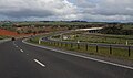
| Спуститься с Баррабул -роуд, глядя на юг в сторону прудов Уорн | |
 NE end SW END | |
| Координаты | |
| Общая информация | |
| Тип | Автострада |
| Длина | 27,6 км (17 миль) [ 1 ] |
| Открыл | 2008–2013 |
| Номер (я) маршрута | |
| Основные перекрестки | |
| NE end | Кожа, Джилонг |
| SW END | Waurn Ponds, Виктория |
| Место (ы) | |
| LGA(s) | Город Большой Джилонг |
| Крупные пригороды / города | Прекрасные банки , Белл Пост -Хилл , Хэмлин Хайтс , Фьянсфорд , Вандана Хайтс , Уорн Пандс |
| Шоссе | |

( Кольцевая дорога Джилонга ранее известная как обход Джилонга и внешняя автострада Джилонга , официально частью Princes Freeway West [ 2 ] ) - это кольцевая дорога в Австралии рядом с Джилонга западными пригородами от автострады Princes в Корио до шоссе Принцев в Waurn Ponds . Он также соединяется с шоссе Мидленд в направлении Балларата и шоссе Гамильтона .
История
[ редактировать ]первых планов по кольцевой дороге Джилонга Один из датируется 7 марта 1969 года, когда тогдашний орган регионального планирования Джилонга был опубликован. В нем говорилось, что кольцевая дорога может быть отложена на срок до 15 лет. [ 3 ]
В середине 1970-х годов Региональный орган по планированию Джилонга, председатель Колина К. Аткинса Оама, спонсировал План транспорта Джилонга, в котором участвовал ряд вариантов для крупного дорожного строительства в этом районе. на север -юг Один был для автострады вдоль линии Латробской террасы, хотя Джилонг Уэст и Чилуэлл , а другой - для Абердин -стрит, чтобы быть повышенной на крупную дорогу с приобретением 99 домов. [ 3 ] Любое строительство автострады через пригороды города было наложены вето после возражений жителей. Окончательный план выступал за строительство того, что стало кольцевой дорогой Джилонга, хотя он также предположил, что латтробная терраса стала артериальной дорогой с 4 полосами движения. [ 4 ]
В 1979 году Мельбурнская фирма провели акустические испытания на Вандана -Хайтс, чтобы выяснить влияние автострады. [ 3 ] Выравнивание было завершено в 1979 году и появилась в качестве предлагаемой автострады в каталоге Мелвей -стрит в течение ряда лет .
Растущие объемы движения через центр Джилонга привел к тому, что в начале 1989 года преобразована на главную артериальную дорогу, со строительством моста через железнодорожную линию Джилонг-Мелборн в его северной части и мост Джеймс Харрисон через реку Барвон в южной части. [ 5 ]
Дорожная классификация
[ редактировать ]Закон о принятии Закона о управлении дорожными движениями 2004 года [ 6 ] Обязал ответственность за общее управление и развитие основных артериальных дорог Виктории в Vicroads : В 2012 году Vicroads объявил о дороге в рамках автострады Princes Freeway West (автострада № 1500), начиная с Corio-Waurn Ponds Road ( Highway ) в Корио и Закончив в прудах Варн . [ 2 ]
Разделы
[ редактировать ]Проект был переименован в Ring Road Geelong 20 февраля 2007 года. [ 7 ]
Строительство на кольцевой дороге Джилонга началось в начале 2006 года, когда в 2009 году было назначено «Секция автострады», запланированные на пруды Уорн, в общей сложности 384 миллиона долларов от викторианских и федеральных правительств были первоначально предприняты для финансирования первых трех разделов проекта.
Кольцевая дорога Джилонга (тип автострады) должна была быть построена в трех разделах следующим образом:
- Раздел 1: Princes Freeway, Corio to Midland Highway, Bell Post Hill [ 8 ]
- Раздел 2: Мидленд Шоссе, Хэмлин Хайтс на шоссе Гамильтон, Фьянсфорд [ 9 ]
- Раздел 3: Шоссе Гамильтона, Фьянсфорд, Шоссе Принца, Waurn Ponds [ 10 ]
Было много местных дебатов по предлагаемому маршруту для раздела 3. [ 11 ] Окончательное решение было принято 7 июля 2006 года, в то время как строительство началось в сентябре 2007 года. [ 12 ] В конечном итоге было решено, что не будет никаких кругов, когда кольцевая дорога Джилонга откроется для движения.
Sections 1 and 2 were officially opened on Sunday, 14 December 2008.[13] Two days of torrential rain beforehand threatened to disrupt the opening,[14] however it went ahead as planned after a cessation of the storm.[15] The two sections were opened by Victorian Premier John Brumby,[16] who announced the naming of the feature bridge on stage two of the road as the "Lewis Bandt Bridge", in honour of the Ford Australia engineer who is credited as the inventor of the Utility vehicle, in Geelong.[17] Section 3 was opened in June 2009.[18][19]

- Section 4: split into three sub-sections:
- Stage 4A (Connection from Geelong Ring Road to Anglesea Road)
- Stage 4B (Connection from Anglesea Road - Princes Highway West)
- Stage 4C (Surf Coast Highway connection, later renamed Baanip Boulevard)
In October 2007, during the 2007 Federal election campaign the Labor party promised $107.5 million for the fourth stage of the road. It was made up of $45 million for stage 4B, on top of their promise made in September for $62.5 million towards Stage 4A.[20] In May 2008 stages 4A and 4B were given the go ahead, with State Premier John Brumby announcing $65 million in funding for stage 4B, in addition to earlier State Government funding of $63 million for stage 4A. Running from the Princes Highway at Waurn Ponds; it will run from Anglesea Road near Hams Road, through the Blue Circle Quarry to the Princes Highway, near Draytons Road. On 17 December 2008 a $62 million contract was awarded to Fulton Hogan to design and build section 4A of the ring road to Anglesea Road.[21] Section 4A opened in December 2011,[22] and Section 4B opened in February 2013.[23]
The State and Federal Governments have also each committed $110 million to duplicate the Princes Highway to Winchelsea.[24] An extra stage connecting the road to the Surf Coast Highway was also investigated.[25] This stage (Section 4C) opened on 3 June 2015, six months ahead of schedule,[26][27] and later gazetted as Baanip Boulevard, after Willem Baa Nip, a local Wathaurung man well known to the Geelong community during the 1800s.[28]
A shared bicycle and pedestrian pathway has also been built along the freeway from Broderick Road, Corio to Church Street, Hamlyn Heights.[29] Built at a cost of $4 million, the trail will not connect into the Geelong bicycle network, due to a short missing link between Church Street and the Fyansford Common.[30]
Future
[edit]A future extension of the Ring Road known as Section 5 or the Bellarine Link has been proposed which will extend the Geelong Ring Road from Baanip Boulevard to Portarlington Road. Since 2017, early planning has been undertaken by the Victorian Government to determine a preferred alignment for a future extension, however it is unlikely that this section will be built in the short-term.[31] Community consultation was undertaken in December 2021.[32] As of April 2024[update], the link is still being planned and developed.
Construction
[edit]


Sections 1 and 2
The design and construction contract for the 10.5 km-long (6.5 mi) [33] section 1 was awarded to Abigroup in November 2005 for $134.8 million.[29] Construction work commenced on 17 February 2006. Section 2 was delivered via two separate design and construction contracts. The contract for 4.5 kilometres (2.8 mi) of freeway was awarded to Cut and Fill Pty Ltd for $31.7 million, while FRH (now Fulton Hogan) won the $15.5 million contract for the Moorabool River bridges. Construction work on section two commenced on 27 September 2006.[29]
The Creamery Road overpass in Bell Post Hill was the first major element of the project to be opened in January 2007 (a number of minor access road deviations had been completed earlier). The Broderick Road overpass was opened in November 2007.[34] The 200m long bridges over the Moorabool River, the largest on the project, had the final span installed on 6 March 2008. The bridges contain 70 beams and have 12 piers.[35]
In 2007 VicRoads said that section one was to be completed by February 2008, but by that time completion had been pushed out to the middle of 2008.[36] By this time earth works were completed on stage two, with 700,000 cubic metres of earth moved, and installation of noise walls had started along with landscaping.
By May 2008 completion of stages one and two of the road has been delayed until November, with VicRoads stating that "wet and cold weather in recent weeks had prevented sealing the road surface". At this time the Victorian Government permitted the filming of a plane crash scene from the Nicolas Cage film Knowing on the incomplete road at Corio.[37]
Local police expressed concerns about a staged opening of the road, with drivers using temporary shortcuts not suited to heavy traffic and large vehicles.[38]
Construction on sections 1 and 2 reached practical completion when the road opened to traffic on 14 December 2008.
Section 3
The $108.3 million design and construction contract for section 3 was awarded on 25 July 2007 to Abigroup. Section three works include 7.5 kilometres of freeway, the transportation of 4.7 million cubic metres of earth, and twin 110-metre long bridges over the Barwon River.[39] Construction of section 3 commenced on 14 September 2007.[40]
By February 2008 550,000 cubic metres of earth had been moved to the north and south of Barrabool Road, and the foundation works for the arch structure over Wandana Drive were complete.[36] Section three was originally scheduled for completion in the second half of 2009[41] however it was announced in early June 2009 that section three would open 6 months early on 14 June 2009.[18]
Section 4A
The design and construction contract for section 4A was awarded to Fulton Hogan on 16 December 2008 for $61.7 million. Construction began in March 2009 and was completed by the end of 2011.[22]
Economic benefits
[edit]The freeway saves fuel and travel time for commuters and cargo trucks.
The completion of the Geelong Ring Road was expected to bring large economic benefits to the region. Approximately 582 hectares (1,440 acres) of land west of the road has been identified for use as new industrial land,[42] however resistance from nearby residents in the Lovely Banks area to two service station developments cast some cloud over future development.
Criticism
[edit]Some opponents of the construction of the Geelong Ring Road feared that the inclusion of the road in the local Geelong roads ecosystem would have adversely affected the environmental conditions in the Geelong area. One point made was that it would "generate millions of tons of carbon dioxide and carbon monoxide pollution in the Geelong and Corio Bay region".[citation needed]
More likely however is that the overall difference would not be significant, as traffic that would previously have travelled through the centre of Geelong via the main Melbourne Road/Latrobe Terrace/James Harrison Bridge/Settlement Road/High Street/Princes Highway West corridor, would now travel via the Geelong Ring Road, improving the environmental condition for the majority of Geelong residents, by removing that traffic from the most heavily populated areas of the city. There has been no environmental study that shows that the construction of the Geelong Ring Road would adversely affect the environment.[citation needed]
The loss of amenity experienced by residents in the immediate vicinity of the freeway corridor due to the severing of a number of local roads was also a source of criticism, but most of these roads have been reconnected via upgraded existing roads, or the addition of new roads.[citation needed]
The main opposition to this project had nothing to do with environmental issues.[citation needed] In 1991 VicRoads undertook its own study and decided to abandon plans to utilise the Section 3 route in favour of a bypass from Avalon Road across Corio Bay to Point Henry and then along the Barwon River valley to the Surf Coast Highway, Anglesea Road and Princes Highway West.[citation needed]
As a result of VicRoads decision the freeway reservation south of Princes Highway West to the Anglesea Road was abandoned and was developed as residential allotments with the approval of VicRoads and South Barwon Council.
Over the next 11 years many people built houses along the route especially from Wandana Drive to the Princes Highway West. Then in 2001 the Victorian Government initiated a project to investigate options for a Geelong Bypass. It involved a steering committee, technical committee and Community consultation committee. After 18 months the expectations based on information provided to participants was that the VicRoads preferred route would be recommended. To the surprise of almost all[citation needed] Westconnect - the route to the west of Geelong including the abandoned Section 3[citation needed] was recommended. Much later it was found that someone had re-costed the eastern route as a full 2 lanes each way freeway construction - even though such a construction was not warranted[citation needed] - and that re-costing made the eastern route uneconomic.[citation needed]
Immediately opposition was generated by those who had built close to the Ring Road reservation. VicRoads proposes 4 alternate routes with the result that further opposition was generated from people located close to Options 2 and 3.
In May 2005 during negotiations between Planning Panels Victoria and VicRoads over an environmental Effects process, Planning Panels requested VicRoads minimise the Options to be considered. VicRoads obliged by reducing the Options to 1 and 2 [citation needed] , even though Option 3 was the best Option [citation needed]. As a result, during the EES process a huge amount of pressure was put on the Planning Panel[citation needed] in respect of consideration of Option 3 but they only agreed to consider it if neither 1 or 2 satisfied the criteria being considered.[citation needed] In its recommendation, in spite of neither Option 1 or 2 satisfying the criteria [citation needed]. Planning Panels recommended Option 1 plus an urgent need to consider further work to overcome the problems with Option 1 including the fact it ended in the middle of a commercial area with nowhere to go to connect to Anglesea Road et cetera.
As a result, the estimated cost of the route to Anglesea Road and then around to Princes Highway West is $618 million – about $200 million more than Option 3 plus a connection to Anglesea Road would have cost.[citation needed] In addition the fact that the route is 3 km (2 mi) longer than Option 1, that most freight traffic comes from the west,[citation needed] and the route requires trucks to negotiate slopes down into the Waurn Ponds Valley and then back out again[citation needed] means the additional cost to users is around $10 million per annum.[citation needed] Finally around 360 households are located within 160 metres of the Ring Road and subject to noise and diesel engine particulate matter pollution whereas with the Option 3 route only 10 houses would have been within 160 metres.[citation needed]
Exits and Interchanges
[edit]Both Geelong Ring Road and Baanip Boulevard are entirely located within the City of Greater Geelong local government area.
Geelong Ring Road
[edit]| Location[1][2] | km[1] | mi | Destinations | Notes | |
|---|---|---|---|---|---|
| Corio | 0.0 | 0.0 | Northeastern terminus of ring road, route M1 continues north-east along Princes Freeway | ||
| Warrnambool railway line | |||||
| Eastbound entrance and westbound exit only | |||||
| 2.7 | 1.7 | ||||
| Lovely Banks | 4.5 | 2.8 | Southbound BP Service Centre | Southbound exit and entrance only | |
| 4.9 | 3.0 | Northbound BP Service Centre | Northbound exit and entrance only | ||
| 6.2 | 3.9 | Anakie Road – Norlane, Anakie | |||
| Bell Post Hill | 7.6 | 4.7 | Geelong–Ballarat and Western SG railway lines | ||
| 9.6 | 6.0 | ||||
| Moorabool River | 13.2 | 8.2 | Lewis Bandt Bridge | ||
| Fyansford | 14.6 | 9.1 | |||
| Barwon River | 15.8 | 9.8 | Geoff Thom Bridge | ||
| Ceres | 18.1 | 11.2 | |||
| Highton | 21.6 | 13.4 | Rossack Drive (south) – Waurn Ponds | South-westbound exit and north-eastbound entrance only | |
| Waurn Ponds | 22.4 | 13.9 | Waurn Ponds Drive (west) – Waurn Ponds | Roundabout interchange with northbound exit and southbound entrance | |
| 24.5 | 15.2 | Half-dogbone, half-dumbbell diamond interchange | |||
| 27.6 | 17.1 | Draytons Road – Waurn Ponds | At-grade intersection | ||
| Southwestern terminus of ring road, route M1 continues west along Princes Highway | |||||
1.000 mi = 1.609 km; 1.000 km = 0.621 mi
| |||||
Baanip Boulevard
[edit]| Location[1] | km | mi | Destinations | Notes | |
|---|---|---|---|---|---|
| Waurn Ponds | 0.0 | 0.0 | Western terminus of road and route B130 | ||
| 0.5 | 0.31 | Warrnambool railway line | |||
| Mount Duneed | 1.1 | 0.68 | Ghazeepore Road – Bellbrae, Waurn Ponds | ||
| Charlemont | 4.6 | 2.9 | Eastern terminus of road and route B130 | ||
1.000 mi = 1.609 km; 1.000 km = 0.621 mi
| |||||
Gallery
[edit]-
 Looking south from the Midland Highway along section 2 towards the Lewis Bandt Bridge and Waurn Ponds.
 -
 Looking south along section 3 from the Hamilton Highway, towards the Barwon River crossing and the climb over the Barrabool Hills.


See also
[edit]References
[edit]- ^ Jump up to: a b c d "Geelong Ring Road" (Map). Google Maps. Retrieved 21 January 2022.
- ^ Jump up to: a b c VicRoads. "VicRoads – Register of Public Roads (Part A) 2015". Government of Victoria. p. 21. Archived from the original on 1 May 2020. Retrieved 19 October 2021.
- ^ Jump up to: a b c Begg, Peter (1990). Geelong - The First 150 Years. Globe Press. ISBN 0-9592863-5-7.
- ^ Geelong Transportation Plan, Public Discussion Paper No 3, Transportation. Geelong: Geelong Regional Planning Authority. January 1975. p. 157.
- ^ "Rail Geelong: Latrobe Terrace". Retrieved 1 July 2007.
- ^ State Government of Victoria. "Road Management Act 2004" (PDF). Government of Victoria. Archived (PDF) from the original on 18 October 2021. Retrieved 19 October 2021.
- ^ "VicRoads - Geelong Bypass Renamed Geelong Ring Road" (PDF). Archived from the original (PDF) on 30 January 2016. Retrieved 8 May 2007.
- ^ "VicRoads - Section 1 map" (PDF). Archived from the original (PDF) on 30 September 2007. Retrieved 8 May 2007.
- ^ "VicRoads - Section 2 map" (PDF). Archived from the original (PDF) on 27 September 2007. Retrieved 8 May 2007.
- ^ "VicRoads - Section 3 map" (PDF). Archived from the original (PDF) on 27 September 2007. Retrieved 6 February 2007.
- ^ VicRoads - Section 3 Facts Archived 4 September 2007 at the Wayback Machine
- ^ "Costello, Brumby launch Geelong road stage". ABC News. 14 September 2007. Retrieved 16 April 2009.
- ^ "Geelong Ring Road: Open to the Public". YouTube. 14 December 2008. Retrieved 16 April 2009.
- ^ "Rain Cancels Ring Road Family Day". Geelong Advertiser. 13 December 2008. Retrieved 16 April 2009.
- ^ "Green Light for Geelong Advertiser Ring Road Ride-Run". Geelong Advertiser. 14 December 2008. Retrieved 16 April 2009.
- ^ "Ring Road Open for Business". Geelong Advertiser. 15 December 2008. Retrieved 16 April 2009.
- ^ "Brumby Declares Geelong Ring Road Open". Geelong Advertiser. 14 December 2008. Retrieved 16 April 2009.
- ^ Jump up to: a b Jeff Whalley (5 June 2009). "Ring road set to open June 14". Geelong Advertiser. geelongadvertiser.com.au. Archived from the original on 28 September 2012. Retrieved 5 June 2009.
- ^ Jeff Whalley (15 June 2009). "Joy for Geelong commuters as ring road stage three opens". Geelong Advertiser. geelongadvertiser.com.au. Archived from the original on 8 October 2012. Retrieved 30 April 2010.
- ^ "ALP commits $107.5m to Geelong Ring Road". The Age. theage.com.au. 19 October 2007. Retrieved 18 July 2008.
- ^ Ребекка Такер (17 декабря 2008 г.). «Новый роуд Джилонга Кольцевой договор присужден» . Джилонг рекламодатель . geelongadvertiser.com.au . Получено 17 декабря 2008 года .
- ^ Jump up to: а беременный «Годовой отчет Vicroads 2011-12» . Викродс . Мельбурн: Викторианская правительственная библиотечная служба. 18 сентября 2012. С. 6
- ^ «Годовой отчет Vicroads 2012-13» . Викродс . Мельбурн: Викторианская правительственная библиотечная служба. 27 августа 2012 г. с. 20
- ^ Джефф Уалли (9 мая 2008 г.). «Кольцевая дорога будет связана с дублированным шоссе принца» . Джилонг рекламодатель . geelongadvertiser.com.au . Получено 18 июля 2008 года .
- ^ Даниэль Брин (10 мая 2008 г.). «Кольцо уверенности в новой стадии кольцевой дороги Джилонг» . Джилонг рекламодатель . geelongadvertiser.com.au . Получено 18 июля 2008 года .
- ^ «Бульвар Баанип за 90 миллионов долларов официально открывается рано» . Джилонг рекламодатель . 3 июня 2015 года . Получено 17 декабря 2021 года .
- ^ «Годовой отчет Vicroads 2014-15» . Викродс . Мельбурн: Викторианская правительственная библиотечная служба. 3 сентября 2015 г. с. 13
- ^ «Годовой отчет Vicroads 2015-16» . Викродс . Мельбурн: Викторианская правительственная библиотечная служба. 2 сентября 2016 г. с. 29
- ^ Jump up to: а беременный в «Официально запустил подход Джилонга, раздел 2» . Средства массовой информации: министр общественного транспорта . Законодательство.vic.gov.au. 27 сентября 2006 года. Архивировано с оригинала 16 июня 2009 года . Получено 18 июля 2008 года .
- ^ Велосипед Виктория. «Проект обхода Джилонга» . bv.com.au. Архивировано из оригинала 20 июля 2008 года . Получено 18 июля 2008 года .
- ^ «Джилонг Кольцевая дорога (Bellarine Link)» . Основные дорожные проекты Виктория . Roadprojects.vic.gov.au. 2017 . Получено 13 июля 2020 года .
- ^ Build, Big Victoria's Big (26 июня 2023 года). «Джилонг Кольцевая дорога (Bellarine Link)» . Большая сборка Виктории . Получено 24 апреля 2024 года .
- ^ «Auslink Projects: Deelong Ring Road» . Auslink.gov.au. Архивировано из оригинала 21 июля 2008 года . Получено 18 июля 2008 года .
- ^ Лорен Пайк (28 ноября 2007 г.). «Кольцевая дорога делает первые шаги» . Джилонг рекламодатель . geelongadvertiser.com.au . Получено 18 июля 2008 года .
- ^ Джефф Уалли (7 марта 2008 г.). «Депутаты замолчают их шеи, чтобы увидеть рубеж Кольцевой дороги» . Джилонг рекламодатель . geelongadvertiser.com.au . Получено 18 июля 2008 года .
- ^ Jump up to: а беременный Джефф Уэлли (15 февраля 2008 г.). «Строительство мостов над задержкой дороги кольцевой дороги» . Джилонг рекламодатель . geelongadvertiser.com.au . Получено 18 июля 2008 года .
- ^ «Джилонг съемки фильма Николаса Кейджа задержали» . Джилонг рекламодатель . geelongadvertiser.com.au. 29 апреля 2008 года. Архивировано с оригинала 26 февраля 2012 года . Получено 6 июля 2008 года .
- ^ Клайв Дорман (2 мая 2008 г.). «Лучший дорожный полицейский имеет резервирование о частичном открытии Ring Road Geelong» . Джилонг рекламодатель . geelongadvertiser.com.au . Получено 18 июля 2008 года .
- ^ «Джилонг Кольцевая дорога установлена на этап 3» . Средства массовой информации: министр дорог и портов . Законодательство.vic.gov.au. 25 июля 2007 года. Архивировано с оригинала 24 сентября 2007 года . Получено 18 июля 2008 года .
- ^ «Зеленый свет для следующей стадии кольцевой дороги Джилонг» . СМИ релиз: офис премьер -министра . Законодательство.vic.gov.au. 14 сентября 2007 г. Получено 18 июля 2008 года .
- ^ Клайв Дорман (8 мая 2008 г.). «Кольцевая дорога Джилонга замедлилась, предстоящая зима» . Джилонг рекламодатель . geelongadvertiser.com.au . Получено 18 июля 2008 года .
- ^ «Джилонг в медленной переулке над рабочих мест на кольцевой дороге» . Джилонг рекламодатель . 14 апреля 2009 г. Получено 16 апреля 2009 года .
Внешние ссылки
[ редактировать ]- Vicroads - Информация о разделе 1 Архивировано 14 июня 2007 года на машине Wayback
- Vicroads - Информация по разделу 2
- Vicroads - Информация по разделу 3
- Vicroads Geelong Ring Road Информация о проекте проекта
- Джилонг Кольцевая дорога - Раздел 1, Abigroup
- Кольцевая дорога Джилонг - раздел 2, вырезать и заполнить Pty Ltd
- Джилонг Кольцевая дорога - Раздел 3, Abigroup
- YouTube видео открытия - Ring Road Geelong: открыта для публики
Дорожная инфраструктура в Виктории |
|---|