Coropuna

| Coropuna | |
|---|---|
| Nevado Coropuna | |
 | |
| Highest point | |
| Elevation | 6,377 m (20,922 ft)[1] |
| Coordinates | 15°33′S 72°39′W / 15.550°S 72.650°W[2] |
| Naming | |
| Etymology | Etymology |
| Native name | Qhuru Puna (Quechua) |
| English translation | "Golden mountain", "cold, snowy" or "cut off at the top" |
| Geography | |
 Coropuna | |
| Parent range | Cordillera Occidental, Peruvian Andes |
| Geology | |
| Age of rock |
|
| Mountain type | Stratovolcano complex |
| Type of rock | Geology |
| Volcanic arc | Central Volcanic Zone |
| Last eruption | 1,100 ± 100 or 700 ± 200 years ago |
| Climbing | |
| First ascent | possibly prehistoric |
Coropuna is a dormant compound volcano located in the Andes mountains of southeast-central Peru. The upper reaches of Coropuna consist of several perennially snowbound conical summits, lending it the name Nevado Coropuna in Spanish. The complex extends over an area of 240 square kilometres (93 sq mi) and its highest summit reaches an altitude of 6,377 metres (20,922 ft) above sea level. This makes the Coropuna complex the third-highest of Peru. Its thick ice cap is the most extensive in Earth's tropical zone, with several outlet glaciers stretching out to lower altitudes. Below an elevation of 5,000 metres (16,000 ft), there are various vegetation belts which include trees, peat bogs, grasses and also agricultural areas and pastures.
The Coropuna complex consists of several stratovolcanoes. These are composed chiefly of ignimbrites[a] and lava flows on a basement formed by Middle Miocene ignimbrites and lava flows. The Coropuna complex has been active for at least five million years, with the bulk of the current cone having been formed during the Quaternary.[b] Coropuna has had two or three Holocene eruptions 2,100 ± 200 and either 1,100 ± 100 or 700 ± 200 years ago which generated lava flows, plus an additional eruption which may have taken place some 6,000 years ago. Current activity occurs exclusively in the form of hot springs.
Coropuna is located 150 kilometres (93 mi) northwest of the city of Arequipa. People have lived on the slopes of Coropuna for millennia. The mountain was regarded as sacred by the Inca, and several archaeological sites have been discovered there, including the Inca sites of Maucallacta and Acchaymarca. The mountain was considered one of the most important Inca religious sites in their realm; human sacrifices were performed on its slopes, Coropuna forms part of many local legends and the mountain is worshiped to the present day.
The ice cap of Coropuna, which during the Last Glacial Maximum (LGM) had expanded to over 500 km2 (190 sq mi), has been in retreat since at least 1850. Estimates published in 2018 imply that the ice cap will persist until about 2120. The retreat of the Coropuna glaciers threatens the water supply of tens of thousands of people relying upon its watershed, and interaction between volcanic activity and glacial effects has generated mudflows that could be hazardous to surrounding populations. Because of this, the Peruvian geological agency, INGEMMET, monitors Coropuna and has published a hazard map for the volcano.
Name and etymology
[edit]In Quechua, puna means "plateau", and coro is a common component of toponyms such as with Coro Coro, Bolivia, though its etymology is unclear.[5] The name may mean Qoripuna, "Puna of Gold",[6] "golden mountain",[7] "cold, snowy" or "cut off at the top".[8] The name is also spelled Qhuru Puna.[9] The mountain is also called Nevado Coropuna; "Nevado" is the Spanish word for "snowy".[10] There is another volcano in the Andahua volcanic field which has the same name, but is completely separate.[11]
Geography and geomorphology
[edit]Coropuna lies in the Andes of Peru,[12] on the border between the Castilla and Condesuyos Provinces[13] of the Arequipa Department.[13][14] Towns around the volcano belong to the Chuquibamba, Machaguay, Pampacolca and Viraco Districts.[15] The volcano can be reached on paved roads through the town of Andahua, either from Arequipa or through Aplao from the Pan-American Highway.[16] Roads also pass along the northern and western sides of the volcano.[17]
Regional
[edit]The Andes stretch along the western coast of South America from Tierra del Fuego northwards to Venezuela, forming the longest mountain chain in the world.[18] More regionally, the volcano is in the Cordillera Ampato, a mountain range which lies at an average of 100 kilometres (62 mi) from the Pacific coastline,[19] and contains nearly one hundred glaciers.[20]
Coropuna is in the Central Volcanic Zone of the Andes,[12][21] which contains 44 stratovolcanoes[22] – including many of the world's highest[21] – and several glaciated volcanoes.[23] Besides Coropuna, some of the latter are Sara Sara, Solimana, Mismi, Ampato, Hualca Hualca, Sabancaya, Chachani, Misti, Ubinas, Huaynaputina, Tutupaca, Yucamane and Casiri.[24][25] Also found nearby are Neogene-age calderas.[24] Sixteen volcanoes in Peru are active or potentially active.[26]
There is no habitation on Coropuna above 5,200 metres (17,100 ft),[27] but numerous villages dot the lower slopes.[c] Agriculture and animal husbandry are the most common economic activities;[29] there are copper and gold mines as well.[30] The city of Arequipa lies 150 km (93 mi) to the southeast.[12]
Local
[edit]General outline
[edit]
Seen from above, Coropuna has a pear-shaped outline[31] and is a 20 km (12 mi) east–west ridge[14] that features four summits that are separated by broad saddles.[12][32] In addition, there is another summit north of the east–west trend.[1] A 5,558 m (18,235 ft) high subsidiary peak named Cerro Cuncaicha lies east of Coropuna;[33] it is a stratovolcano.[34] Coropuna covers a surface area of 240 square kilometres (93 sq mi)[35] and its various main summits rise about three kilometres (1.9 mi) above the surrounding plateau.[23]
The volcano is formed from alternating layers of ignimbrite and lava,[31] and consists of coalesced stratovolcanoes[36] and seven separate coulees.[37] Ice cover makes discerning its structure difficult,[38] but about[38] six separate peaks[35][39][40] as well as six not readily recognisable summit craters have been counted.[28][31] Additional lava domes form a southeastward trending line on the southwestern side of the volcano[28] and dikes crop out close to Lake Pallarcocha.[28] Coropuna overlies the margin of a buried caldera.[41]
The higher elevations of Coropuna consist of an ice cap and glaciated terrain[35] but old lava flows with gentle slopes[42] and blocky lava crop out from underneath the ice.[22] Regions of hydrothermally altered rocks, lava flows, pyroclastic flows and areas covered by volcanic ash occur all around the mountain.[28] Glacial activity has eroded these volcanic rocks, carving valleys into them or removing them altogether.[43] This process created U-shaped valleys such as Buenavista, Cospanja and Tuilaqui on the southern flank, and glacial valleys such as Chaque, Mapa Mayo, Río Blanco, Torcom and Ullulo on the northern slopes.[44] Glacial valleys of Coropuna are up to 300 m (980 ft) deep and seven km (4.3 mi) long.[45]
There are several collapse scarps on the mountain, especially around its central sector.[34] A sector collapse took place on the southwestern flank and formed a landslide deposit as well as a horseshoe-shaped valley that was later filled by glaciers.[45] Also on the southern side, mud-water flow deposits have been found in the Capiza River valley and appear to relate to Coropuna;[46] at least eight such debris flows have been identified.[47] Lahars (mudflows) have reached the Colca River valley.[48] Lahars are dangerous phenomena owing to their high speed and density, causing large scale destruction and fatalities,[46] and can be generated both by volcanic and meteorological processes.[49]
Lakes and rivers
[edit]
Lakes lie on the flanks of the volcano.[50] These include Lake Pallarcocha on the southwestern flank on formerly glaciated terrain,[51] Laguna Pucaylla on Coropuna's northeastern side and Laguna Caracara on the southeastern side. A number of streams and rivers originate on the mountain. Clockwise around Coropuna, these include Quebrada Chauqui-Huayco, Rio Amayani on the northern side, Quebrada Chinchina/Infernillo, Quebrada Jollpa, Quebrada Caspanja with the lake Laguna Caracara, Quebrada Buena Vista, Quebrada Tuallqui, Rio Testane on the southern flank, Rio de Huayllaura on the southwestern flank, Quebrada del Apacheta,[17] Quebrada Sigue Chico[52] and Quebrada Sepulturayoc on the western flank.[17] The Rio Blanco and Rio Amayani eventually form the Rio Arma,[53] while the Rio Capiza discharges water from Coropuna to the Colca River.[54] During the winter dry season,[2] most of these rivers do not carry substantial discharge.[55]
The volcano is situated on a drainage divide.[56] To the west, the Rio Arma is a tributary of the Ocoña River, while to the east, the Colca River is part of the Majes River watershed.[43] An endorheic area that receives meltwater from the volcano also exists northeast from Coropuna, on Pampa Pucaylla[57] where the lake of the same name lies.[17]
Surrounding terrain
[edit]Coropuna rises two km (1.2 mi) above the surrounding terrain[2][32] from a base elevation of 4,500 m (14,800 ft),[14] and about 3.5 km (2.2 mi) on the southern side where the Rio Llacllaja has incised the underlying basement[2][32] almost to the foot of the volcano, forming sharp, amphitheatre-like valleys.[55] In general, many deep valleys cut into the flanks of the volcano[58] and give the mountain an "impressive topographic relief".[1]
The region is characterised by high plateaus separated by deep canyons, including some of the world's deepest gorges[52] that reach depths of 600–3,000 m (2,000–9,800 ft).[59] Apart from river erosion, giant landslides have affected the Altiplano below Coropuna,[60] such as the Chuquibamba landslide, which took place over the last 120,000 years in the form of multiple collapse events within a fault-controlled basin.[61]
Geomorphologically, Coropuna lies at the edge of the Altiplano high plateau on the Western Cordillera mountain range;[62] in the Central Andes this mountain chain is split into two ranges – the western and the eastern Cordillera – separated by the Altiplano.[63] The Pucuncho Basin[10] and Firura volcano lie north of Coropuna, while Solimana volcano is northwest from Coropuna.[12] Sara Sara is another volcano in the area.[35] A large lava dome lies northwest of Coropuna[17] while Cerro Pumaranra, a 5,089 m (16,696 ft)[33] eroded volcano, is to the northeast.[28] 19 km (12 mi) west-southwest from Coropuna lies the 4,855 m (15,928 ft) high Antapuna,[64] while the Andahua "Valley of the Volcanoes" is 20 km (12 mi) east-northeast of Coropuna.[65]
Elevation and size
[edit]
Coropuna is the largest[66] and highest volcano in Peru, the highest peak of the Cordillera Ampato[2] and the third-highest mountain in Peru.[6][7] The highest point of Coropuna is the northwestern dome[1][35] named Coropuna Casulla,[15] with 6,377 metres (20,922 ft) elevation.[1][67][40] Mountaineering sources also cite an elevation of 6,425 m (21,079 ft) for the El Toro summit,[68][69] which would make Coropuna the 22nd highest mountain in the Andes.[22][d]
Estimates on the height of Coropuna have changed over time. In the 19th century, it was one of the candidates for "highest mountain in Peru", with the Mapa del Perú (Map of Peru) of Antonio Raimondi giving an estimated height of 6,949 m (22,799 ft); other candidates were peaks in the Cordillera Blanca.[73] In 1910 it was believed that the volcano was over 7,000 m (23,000 ft) high and thus the highest mountain in South America, ahead of Aconcagua,[74][75] although a North American expedition during the preceding year had determined that Coropuna was not the highest, as they only found an elevation of 6,615 m (21,703 ft), and Huascaran is higher than this.[76] Varying snow elevations might also lead to varying height estimates.[68]
Coropuna has several summits (up to ten overall according to one count)[31] which exceed 6,000 m (20,000 ft) elevation,[56] plus a 5,623 m (18,448 ft) northern summit.[15] Those with individual names are the northwestern Coropuna Casulla at 6,377 m (20,922 ft),[35] El Toro,[68][69] the western Nevado Pallacocha at 6,171 m (20,246 ft), the central Coropuna Central II at 6,161 m (20,213 ft),[77] Escalera at 6,171 m (20,246 ft) in the western sector of the volcano, Paiche at 6,330 m (20,770 ft) in the central sector,[78][34] and Coropuna Este[79] and Yana Ranra at 6,305 m (20,686 ft) in the eastern sector.[34][78]
Ice cap
[edit]
Coropuna features the largest ice cap of the tropics.[46] As of 2014 it was 8.5 km (5.3 mi) wide and eleven km (6.8 mi) long.[80] It is larger than the Quelccaya Ice Cap 250 km (160 mi) farther northeast, which was considered to be the largest,[80][81] but has since shrunk to a size less than Coropuna's.[82] A subsidiary peak named Cerro Cuncaicha, east of Coropuna, has a small ice cap as well.[83] In general, Peruvian glaciers form the bulk of the world's tropical glaciers.[84] The ice cap consists of three ice domes and many glaciers.[80] Perennial snow fields are present on Coropuna, sometimes making it hard to measure the true extent of glaciation or glacier retreat.[32]
On average, the ice cap of Coropuna is about 80.8 m (265 ft) thick,[85] with maximum thicknesses exceeding 180 m (590 ft).[86] In 2003–2004 the ice cap had a volume of about 3.69 cubic kilometres (0.89 cu mi) snow water equivalents.[87] Ice cores have been taken from the Coropuna ice cap[88] and from a summit crater;[89] one of these ice cores covers a timespan beginning from 20,000 years ago.[90]
Penitentes[19] reaching heights of two m (6 ft 7 in)[91] and seracs (blocks of ice in glaciers delimited by cracks) occur on the glaciers,[28] while debris cover is rare.[92] Mudflows (lahars) originated from the ice cap[2] and left deposits at the bottom of valleys.[58]
Glaciers and periglacial phenomena
[edit]A number of glaciers flow down from the ice cap,[28] their number variously estimated to be 15,[32] 17[93][56] and 23.[80] Some glaciers have been named; on the southwestern flank two glaciers are known as Azufrioc 1 and 2, three Rio Blanco 1 through 3 and six Tuialqui 1 through 6.[94] Eighteen separate accumulation areas have been found as well.[95] There are no substantive valley glaciers presently on Coropuna[38] and some glaciers, especially in the eastern side, emanate from cirques.[28] The ongoing downward movement of the ice on Coropuna produces icequakes.[40][96]
Glaciers descend to elevations of about 5,100 to 5,300 m (16,700 to 17,400 ft) on the southern flank, and to about 5,500 to 5,800 m (18,000 to 19,000 ft) on the northern flank.[12][37][80] This is higher than the freezing level, owing to the dry climate;[2] the freezing level at Coropuna lies at about 4,900 m (16,100 ft) elevation.[32] In 2001, the ice limits were located at elevations of 5,300 m (17,400 ft) on the southern and at 5,600 m (18,400 ft) on the northern flank.[97]
Moraines are mostly found on Coropuna's northern and southern side[17] and reach lengths of three to eight km (1.9 to 5.0 mi), with longer moraines on the northern flank.[44] In general, moraines on Coropuna are steep and have prominent crests as they are little eroded.[83] Grey-coloured, fresh moraines up to 500 m (1,600 ft) from the ice cap may reflect the position of the glaciers before the onset of glacier retreat which has left small mounds that often contain ice between these moraines and the ice cap[83] and small, discontinuous moraines.[98]
Apart from normal glaciers, 78 rock glaciers have been counted on Coropuna, but only 11 of them are considered to be active.[99] Permafrost occurs at elevations exceeding 5,100 metres (16,700 ft) on the southern and 5,750 metres (18,860 ft) on the northern flank.[100] Cryoturbation,[101] gelifluction, patterned grounds,[31] solifluction[102] and other periglacial landforms are noticeable[31] at over 4,500 m (14,800 ft) elevation.[31]
Recent area and retreat
[edit]
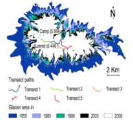
Measuring the surface area of Coropuna's ice cap is difficult as seasonal snow can be mistaken for ice,[105] and different studies come to various conclusions about the retreat rate, due to the use of different time periods and methodological practices. However, all studies conclude that the net retreat trend is obvious and that the ice cap is diminishing.[106] Retreat rates shortly before 2009 reached 13 per cent in only 21 years.[107] Between 1980 and 2014 the ice cap shrank at a rate of 0.409 km2/a (0.158 sq mi/a)[80] with a 2015 estimate amounting to 0.5 km2/a (0.19 sq mi/a),[108] and a brief slowdown observed during the late 1990s and early 2000s.[109] Total shrinkage has been estimated to amount to 26 per cent between 1962 and 2000, and by 18 per cent between 1955 and 2007.[2] Retreat is faster on the northern side of the mountain.[110]
The Coropuna ice cap retreat follows the pattern recorded elsewhere in Peru such as in the Cordillera Blanca, Cordillera Vilcanota and the mountains Ampato, Quelccaya and Sabancaya.[111] All of this retreat is attributed to global warming,[97] and tends to increase during El Niño years owing to a drier climate. The glaciers lose mass through both sublimation and melting.[32] Ablation occurs year-round and is diurnal.[112] This meltwater rarely forms streams, though some do exist. The Quebrada Ullulo on the northern side is the largest such meltwater stream.[32] Recently deglaciated terrain is covered by rock debris.[113]
-
 Glacier trends and extrapolation
 -
 Ice profile
 -
 Ice thickness
 -
 Ice schematics


Glacial history
[edit]Before the first human settlement of the area,[114][115] the ice cap on Coropuna was much larger than today, with its surface exceeding 500 km2 (190 sq mi)[116] and its glaciers descending to much lower elevations.[52] Additionally, glaciers also expanded from the mountains Pumaranra, Pucaylla and Cuncaicha to the east of Coropuna.[117] They covered the Pampa Pucaylla northeast from Coropuna and descended the Jellojello valley and other valleys to the east.[118] Glacial valleys radiate from Coropuna,[38] and glaciofluvial landforms are associated with moraines.[32]
Regional climate oscillations are recorded in the ice masses of Coropuna.[119] The glacial history of the volcano has been reconstructed with tephrochronology (using dated tephra layers such as those from the 1600 Huaynaputina eruption), radiocarbon dating[37] and surface exposure dating using helium-3.[32] Three separate moraine generations[34] and about five separate glacial stages have been recorded on the volcano.[120] Glacial advances on Coropuna appear to be synchronous to advances of the ice sheets in the Northern Hemisphere.[121] Glaciers developed on other mountains in the region as well.[122]
Last glacial maximum
[edit]During the Last Glacial Maximum (LGM) 25,000–20,000 years ago,[79] valley glaciers on Coropuna were considerably longer than today.[37] The longest glacier, at 12 km (7.5 mi), was in the Quebrada Ullulo.[79] The glaciers had a cover of boulders and gravel and formed tall moraines, and both lateral and terminal moraines where outlet glaciers ended. At the crest, these moraines were as much as 100 m (330 ft) high, eight km (5.0 mi) long, and five–ten m (16–33 ft) wide.[123] On the northern flank, moraine systems have been observed in the Santiago, Ullulo,[124] Keaña, Queñua Ranra, Cuncaicha, Pommulca and Huajra Huire valleys,[57] while the southeastern flank was covered by glaciers in the Yanaorco, Viques, Cospanja, Buena Vista Este, Buena Vista Oeste and Huasi valleys.[118] Rock bars occur in some glacial valleys on the southern and southwestern side of the volcano.[28] There are large cirques around Cerro Cuncaicha.[37][83]
The LGM ice cap had an area of at least 365 km2 (141 sq mi), with glaciers descending to 3,780–4,540 m (12,400–14,900 ft) elevation. Glacier ends were lower on the northern[79] and western sides, probably due to airflow-mediated variations in sublimation.[125] The growth of the ice cap has been explained by a decrease of the equilibrium line altitude of about 750 m (2,460 ft). Assuming constant precipitation, temperatures may have decreased by 4.5–5.5 °C (8.1–9.9 °F).[126] The glaciers began to retreat between 12,000 and 11,000 years ago.[127]
Other glacial periods
[edit]Ice has been present on Coropuna for at least 80,000 years.[128] At least two pre-LGM advances spread beyond the area that was covered with ice during the LGM,[32] with an expansion occurring in particular in the eastern sector of the volcano.[129] Moraines older than marine isotope stage 2 are widespread.[130] Those close to the village of Viraco may date back 40,000–45,000 years and thus be part of an earlier glaciation,[131] and old dates of 47,000–31,000 and 61,000–37,000 years ago in the Huayllaura and Sigue Chico valleys could reflect even larger glacier expansions during marine isotope stage 3 or 4.[132]
Glaciers retreated after the end of the last glacial maximum 20,000–18,000 years ago and then re-expanded.[120] During the Late Glacial, a group of moraines formed between the position of the LGM moraines and the position of the recent moraines,[83] with one lateglacial advance dated to either 13,400–10,000 or 13,900–11,900 years ago.[133] Full glacial conditions lasted until 10,000–9,000 years ago;[128] minor advances took place about 13,000–9,000 years ago, and again some 6,000 years ago.[134] The late glacial advances coincide with similar glacier expansions worldwide[135] and some of them may correlate with the Younger Dryas cold period or the Antarctic Cold Reversal.[136] During the Little Ice Age, glaciers on Coropuna did not expand much, although some rock glaciers might have formed during that time. The glaciers descended to 4,900 m (16,100 ft) elevation.[121]
Importance as a source of water
[edit]Glaciers in Peru are important sources of water for local communities and for hydropower generation, especially during the dry season; their shrinkage is thus of concern.[137] A 2003 study by Bryan G. Mark and Geoffrey O. Seltzer estimated that about 30 per cent of the dry season runoff in the Cordillera Blanca comes from glaciers.[138] Meltwater from the glaciers on Coropuna sustains the baseflow of the rivers[139] during dry periods;[93] Coropuna is an important source of water for the valleys of the surrounding areas and for the desert-like piedmont,[111] with an estimated 38,000 people depending directly or indirectly on water originating from it.[72] This water supply is threatened by the retreat of the glaciers[111] and would require costly mitigation measures to compensate for its reduction. The Peruvian government is making preparations for Coropuna ceasing to be a contributor to the local water supply by 2025; a 2018 study and re-evaluation of past data concluded that the ice cap should persist until about 2120, and recommends that greater in situ monitoring of Coropuna's glaciers is needed to aid future planning and mitigation.[140] Glacial meltwater has a low content of regulated metals[141] while springs sometimes have very high concentrations.[142]
Geology
[edit]Regional setting
[edit]
Off the coast of Peru, the Nazca Plate subducts beneath the South American Plate at a rate of five–seven centimetres per year (2.0–2.8 in/year)[143] or nine centimetres per year (3.5 in/year).[144] This subduction process, along with the subduction of the Antarctic Plate also underneath the South American Plate, is responsible for the volcanism in the Andes and the uplift of the mountain chain.[145] In the Cordillera Occidental (Western Cordillera) uplift commenced about 50 million years ago in the Eocene, paused until 25 million years ago in the Oligocene, and increased substantially after about 10 million years ago in the Miocene.[146] Andean uplift in the area of Coropuna is ongoing.[31]
Coropuna is part of the volcanic arc of southern Peru[46] and is considered to be a member of the Barroso volcanic arc.[97] There are over six hundred volcanoes in southern Peru,[147] and the entire Cordillera Occidental from southern Peru to northern Chile is covered with volcanic rocks, although present-day volcanic activity is scarce.[55] Many of the older volcanoes are deeply eroded by glaciation, while younger volcanoes often still resemble cones.[63]
Volcanic activity in the Andes occurred during three eras. The first was between 195 and 190 million years ago in the Early Jurassic, and generated the Chocolate Formation. The second between 78 and 50 million years ago (Late Cretaceous to Early Eocene) generated the Toquepala Formation and the Andean batholiths.[146] Volcanic activity in southern Peru commenced about 13 million years ago in the Miocene.[148] One volcanic unit – after being folded and eroded – was covered by a second lava and tuff unit, which in turn was followed by the emplacement of large volcanoes.[63] Ignimbrites and stratovolcano activity, at times subdivided into a "rhyolitic" and an "andesitic" formation, alternated.[55]
Basement
[edit]Coropuna is constructed atop of 14 million year old ignimbrites[66] and lava flows of Neogene age.[14] Individual ignimbrites crop out mainly in valleys; on the highlands they are buried beneath more recent volcanic products.[31] The volcanic basement includes the Miocene to Plio-Pleistocene Tacaza, Huaylillas, Sencca and Barroso Formations; the latter formation includes Coropuna itself. Below these formations lie the sedimentary Murco and Socosani formations and the Yura Group, which are sediments of Jurassic-Cretaceous age with intruded plutons of the same age; finally there is a Basal Complex of Precambrian age.[149]
Faults and lineaments
[edit]The basement is cut by faults and lineaments such as the Viraco-San Antonio Fault that crosses the edifice,[150] Pampacolca Fault on the southern side of the volcano and the Pumaranra and Cerro Casulla lineaments,[148] which trend southeast–northwest and northeast–southwest, respectively. One east–west lineament may have influenced the recent volcanism;[151] the alignment of Coropuna with Sara Sara, Solimana and El Misti may indicate a tectonic control on the volcano in general.[152] On the southern flank, Holocene normal faults have offset lava flows and streams.[38]
Composition
[edit]The rocks released by Coropuna are dark brown to black and porphyritic.[153] They consist of andesite,[2] dacite,[43] rhyodacite,[154] rhyolite,[155] trachy-basaltic andesite, trachyandesite and trachydacite.[156] The more recent lava flows have been dacitic[157] or trachydacitic.[15] Phenocryst phases include amphibole, biotite, plagioclase, pyroxene and titanomagnetite.[66] Aside from the volcanic rocks, deposits of salts, sulfur and travertine produced by hot springs are found on the southern flank.[158]
The volcanic rocks define a calc-alkaline[155] potassium-rich suite which resembles that of[156] Chilean[159] and Peruvian volcanoes such as Tutupaca.[156] They contain large amounts of rubidium, strontium and barium.[156] Complicated processes[160] of crystallisation and interaction with Earth's crust appear to have produced the magma.[161]
Eruption history
[edit]The beginning of Coropuna's growth has variously been placed over 5 million years ago,[162] during the Pliocene[163] or late Miocene, but most of its structure developed during the Quaternary.[12] Volcanic activity has been subdivided into two stages: explosive eruptions during the now mostly eroded Coropuna I stage produced volcanic ash, pyroclastic flows and pumice but also lava flows, while Coropuna II above 6,000 m (20,000 ft) elevation erupted lava flows from the now snow-covered vents.[57][164] The existence of a Coropuna III sequence has been proposed.[157] The most recent eruption products have been described as the "Andahua Group".[165] About 5.3 million years ago, the Sunjillpa volcano was active southwest from Coropuna,[34] while Cunciacha east of Coropuna is of lower Pleistocene[78] and Pumaranra of Pliocene to Quaternary age.[57]
A major ignimbrite eruption took place about 2 million years ago at Coropuna; its deposits have been identified west of the volcano[166][43] and it led to the destruction of the edifice, which later re-formed on the remains of the old volcano.[55] The occurrence of explosive eruptions during a mostly effusive activity has been found at Chachani and Sara Sara as well.[55]
In addition, the Upper Sencca Ignimbrite, the Lower Sencca Ignimbrite[167] and the Chuquibamba (Huaylillas[168]) Ignimbrite[169] may have originated here as well;[170] the latter was produced by a volcanic explosivity index 7 class "super-eruption"[171] between 14.3 and 13.2 million years ago in the Middle Miocene.[172] The Upper Sencca Ignimbrites are a 2.09–1.76 million years old[169] composite ignimbrite[173] which form a 10–30 m (33–98 ft) thick apron around Coropuna and other regional volcanoes; Coropuna appears to have formed on top of one of the Upper Sencca Ignimbrite vents.[169]
After a hiatus,[174] volcanic activity continued into the Pleistocene.[43] Several lava flows on the western and central sides of Coropuna have been dated, yielding ages ranging from 410,000 ± 9,000 to 62,600 ± 4,300 years ago.[34] During the last glacial maximum, Coropuna was inactive[71] and moraines buried its lava flows.[23] However, one[71] or two tephra layers on a moraine close to the village of Viraco on the southern side have been dated to be about 41,000 and 30,000 – 31,000 years old. These ages correspond to radiocarbon ages of 37,370 ± 1,160 and 27,200 ± 300 years. These tephras may have originated in fissure eruptions associated with the three recent lava flows.[131] In postglacial times lava bombs, lapilli and volcanic ash were deposited on previously glaciated terrain.[57] Pumice deposits may have formed during the Holocene.[58]
Holocene
[edit]No eruptions of Coropuna during historical[175] or modern times are known,[137] and the volcano was considered to be long-extinct.[39] However, young-looking[38] ʻaʻā lava[176] or block lava[23] flows erupted during the Holocene and in part overlie late-glacial moraines.[12][157][176] Their vents are now hidden beneath glacier ice,[22] and the flows have been affected by later glacial advances.[177] These lava flows are found on the west–northwest, south–southeast and northeast side of the mountain:[83]
- A northwesterly lava flow – Coropuna's longest[157] at 8.5 km (5.3 mi) – occupies the Cerro Sepulturayoc valley.[118] It has been dated to about 6,000 years ago,[118] but research published in 2019 has suggested it may have erupted somewhat earlier, during the Late Glacial period.[178]
- A southeasterly flow lies in the Cospanja valley and is either 1,100 ± 100[179] or 700 ± 200 years old,[34] the latter age being derived from cosmogenic isotope dating.[46] It was probably formed during a single eruption and is four kilometres (2.5 mi) long.[180]
- A dark, young-looking lava[181] flow runs northeasterly[33] in the Queñua Ranra valley[57] and is five kilometres (3.1 mi) long.[182] The eruption took place about 2,100 ± 200 years ago[183] according to cosmogenic isotope dating.[46] Its deposition was preceded by the eruption of lava bombs that cover the valley and by the production of a lahar that advanced 14 km (8.7 mi) from its source. Whether a secondary lava flow in the same valley occurred at the same time or later is not clear, as that flow has not yet been dated.[183]
The ages of the flows indicate an eastward shift in activity.[128] The southeasterly and northeasterly flows may have been erupted within 500 years from the same fissure,[178] while the eruption of the northwesterly flow might be a consequence of the retreat of the ice cap.[184] These lava flows are the most recent manifestation of volcanic activity[15] and they imply that Coropuna is still active;[137] it is thus considered to be a dormant volcano, rather than an extinct one.[185] There is no evidence of Holocene tephras in peat bog drill cores[71] and volcanism at Coropuna since the last ice age has been primarily effusive.[178]
Present day status
[edit]
The volcano is still hydrothermally active.[15] Six hot springs are found on Coropuna, mostly on the southeastern foot,[186] such as at Acopallpa, Antaura/Antauro, Viques, Ccollpa/Collpa, Buena Vista and Aguas Calientes and, on its northern flank, at Huamaní Loma. Their water temperatures range between 18 and 51 °C (64 and 124 °F).[187][188] With the exception of the last two, which are situated in glacial terrain, these hot springs rise within valleys via rock fractures.[158] Geochemical analyses of the water from these springs published in 2015 show no major variations in composition, implying a stable volcanic system.[189] Whether solfataric or fumarolic activity occurs at Coropuna is unclear,[1][190][188] and the thick glaciation indicates that the summit craters have no thermal activity.[38] A lahar took place on the southeastern flank on 22 December 2016, causing damage to water infrastructure[191] and pastures below the volcano.[192]
Some of the hot springs on Coropuna are used for bathing.[158] The volcano had been considered a potential site for geothermal power production,[193] but research published in 1998 concluded that the available energy of the Coropuna area was insufficient.[194]
The first volcano activity report published in 2018 noted ongoing seismic activity involving volcano-tectonic earthquakes.[40] Seismic swarms were observed at Coropuna after the 2001 southern Peru earthquake[195] and were possibly triggered by that earthquake.[196] Observations of deformation of the volcanic edifice have shown that gravitational instability and soil water absorption result in movements of part of the volcano but, as a whole, Coropuna shows no evidence of volcanic deformation.[197]
Hazards and monitoring
[edit]The Peruvian Instituto Geológico Minero y Metalúrgico (INGEMMET) monitors Coropuna for activity. It uses data such as the composition of hot spring waters[198] and the shape of the volcano as estimated by satellite images,[199] GPS and geodesy,[200] as well as information from five seismic stations.[67] Seismic monitoring of the volcano began in 2008-2010 and was supplemented with geophysical monitoring in 2018.[201] A volcanic hazard map[202] and scenarios of lahar generation have been published,[49] the Peruvian government publishes regular status reports.[203] The Peruvian Geophysical Institute considers Coropuna a "high risk" volcano;[204] about 90,000 people live in risk areas,[67] and the sites most in danger are towns in the steep southern valleys.[156]
Together with El Misti, Sabancaya and Ubinas, Coropuna is considered to be one of Peru's most dangerous volcanoes.[205] The presence of a large ice cap,[206] and therefore the risk of incandescent volcanic rocks melting that ice, creates a hazard of lahars, or mudflows, such as those that in 1985 killed over 23,000 people at Nevado del Ruiz volcano in Colombia.[29][137] The risk to life is further increased by Coropuna's steep slopes and by the concentration of people in nearby valleys.[207] The terrain around the volcano has one of the greatest topographic reliefs in the world and a number of towns lie on the floor of the Majes valley, right down to the Pacific Ocean where the district capital Camaná[38] with 20,000 inhabitants is situated.[175] Although there is no evidence of past mudflows of such size, lahars could reach as far as the coast,[208] affecting a number of towns[209] and infrastructure such as roads, antennas and small hydropower plants[29] in the provinces Condesuyos, Castilla and Camaná.[190] According to the 2007 census, 110,481 people lived in the provinces that span Coropuna and lie downstream of it.[137]
Lava flows are also a potential danger at Coropuna.[156] Other hazards with lesser probabilities are directed volcanic blasts, lava dome collapses,[156] fast-moving massive pyroclastic flows[210] and flows of pumice and volcanic ash,[156] lava bombs[211] and shock waves from volcanic explosions.[212]
Climate
[edit]Precipitation
[edit]Coropuna lies between the semi-humid Altiplano and the arid western slope of the Andes.[213] Its climate is semi-arid, with precipitation at 6,080 m (19,950 ft) elevation reaching 390 millimetres per year (15 in/year).[12] Other reported precipitation values range between 700 mm/a (28 in/year)[214] and 1,000 mm/a (39 in/year).[52] Lower down the mountain, at altitudes between at 3,000 and 4,000 m (9,800 and 13,100 ft), annual precipitation levels increase to between 226 and 560 mm/a (8.9 and 22.0 in/year) (semi-humid). Even further down, at altitudes around 2,000–3,000 m (6,600–9,800 ft), they decrease again to 98–227 mm/a (3.9–8.9 in/year) (desert).[27] Cold water brought from Antarctica along the Pacific Ocean by the Humboldt Current,[215] the presence of a stable anticyclone [216] and of a temperature inversion over the Pacific, and the Andean rainshadow are all responsible for this dryness.[12]
Most precipitation falls as hail or snow.[27] This happens mostly during the summer[12] wet season, between December and March,[52] when the ITCZ moves south[217] and a summer monsoon is active over South America.[215] Most precipitation is brought by easterly winds coming from the Amazon and the Atlantic Ocean, whereas the westerly winds that dominate during the dry season do not carry much moisture.[2] Thus, humidity generally decreases in a westward direction.[216]
The amount of precipitation is modulated by the El Niño Southern Oscillation. During phases of El Niño, the weather is drier, snow cover smaller and glacier retreat increases.[111][218] Over longer timespans, precipitation in the region increases whenever iceberg discharge and cooling occur in the North Atlantic. This was the case during the Heinrich events and the Younger Dryas when lakes formed on the Bolivian Altiplano: The Sajsi formed about 25,000–19,000 years ago, Tauca about 18,000–14,000 and Coipasa 13,000–11,000 years ago.[215] Cold periods in the Southern Hemisphere such as the Antarctic Cold Reversal between 14,500 and 12,900 years ago may have pushed the polar front north and increased precipitation as well.[216] That increased precipitation may have delayed the retreat of Coropuna's glaciers after the end of the last glacial maximum.[219] Coropuna experienced moist conditions during the early Holocene, whereas the late Holocene beginning 5,200 years ago was drier there,[220] with a pronounced dry period lasting from 5,200 to 3,000 years ago.[221]
Temperature
[edit]Temperatures decrease with altitude gain, and at lower elevations around 2,000–3,000 m (6,600–9,800 ft) they average 12–17 °C (54–63 °F). Between 3,000 and 4,000 m (9,800 and 13,100 ft) they average 7.8 °C (46.0 °F) and at 4,000–5,200 m (13,100–17,100 ft) elevation they average 0–6 °C (32–43 °F). At altitudes above 5,200 m (17,100 ft) they remain below freezing.[27] Temperatures fluctuate more over daily timescales than over seasonal ones when measured close to the glaciers.[56] Southerly cold waves can sometimes reach Coropuna, leaving traces in ice cores in the form of southern pollen.[222] During the Little Ice Age, at 5,000–5,200 m (16,400–17,100 ft) elevation temperatures decreased to −5 to −7 °C (23 to 19 °F).[121] Warm fluctuations between about 2,200 and 900 years ago, plus a cold fluctuation between around 970 to 1010 AD, are also recorded.[223]
Vegetation, fauna and agriculture
[edit]
Most of the region is covered by puna grassland, with the exception of isolated Polylepis woods to the southwest of the volcano, plus other different vegetation types to the west and southeast.[224] Peat bogs are present on the southern and southwestern sides of Coropuna, and some of these have been drilled to obtain sediment cores.[28][37] There are several private conservation areas around the volcano.[225] Elsewhere, agriculture is widespread around Coropuna.[28] Insects such as beetles and hymenopterans, birds such as the Andean condor,[91] fish, and mammals such as the alpaca, llama[226] and vicuña occur in the region.[91] Several new species of butterfly have been discovered there.[227]
The mountain has several distinct vegetation belts:
- Between 800 and 2,500 m (2,600 and 8,200 ft) lies steppe vegetation with Ambrosia shrubs and cacti. Irrigation permits the cultivation of garlic, olive, onion, potato, rice, sugar cane and wheat. Pastures are also present.[228]
- The steppe vegetation is also present between 2,500 and 3,500 m (8,200 and 11,500 ft) in the "pre-Puna", but it is denser here[226] and includes shrubs of the family Asteraceae, such as Ambrosia, Diplostephium and Senecio.[70] Crops grown here include alfalfa, but there is also some dairy farming and the planting of eucalyptus and pine trees as a wood supply for the local population.[226]
- Between 3,000 and 4,000 m (9,800 and 13,100 ft) lies a so-called "supra-tropical facies" on soils overlying lava flows. It includes shrubs and thorny vegetation in very wet and very dry areas, respectively. Agriculture is practised here, including the growing of kiwicha, maize, quinoa and vegetables on anthropogenic soils[229] and terraced fields.[226] Dominant natural plants between 3,500 and 4,000 m (11,500 and 13,100 ft) include herbaceous plants of the families Fabaceae and Solanaceae, as well as shrubs of the Asteraceae.[70]
- Between 4,000 and 4,800 m (13,100 and 15,700 ft) vegetation is found in marshes and peat bogs where sufficient water is available, in the form of relic Polylepis woodlands as well as herbaceous puna vegetation[230] which is particularly prolific during the wet season. These areas are used for pasture of alpacas and llamas, and for fishing in wetlands and Polylepis woods; hamlets are found close to wetlands and forests.[226] Plant genera found here include Baccharis, Calamagrostis, Chuquiraga, Festuca, Parastrephia, Senecio and Stipa.[70]
- Above 4,800 m (15,700 ft) lies the so-called "Puna brava", with herbs and deep-rooted plants that have all adapted to withstand permafrost conditions.[231] The cushion plant, yareta, which is used as a fuel source, is the dominant plant in this belt.[232] Other plants from the Apiaceae and Asteraceae also occur.[88] Vegetation, including ichu grass and yareta, exist up to about five km (3.1 mi) elevation; higher elevations are unvegetated.[83]
Archaeology and religious importance
[edit]На Коропуне расположены многочисленные археологические памятники, особенно у южного и северного подножия вулкана и на его западном склоне. [28] Among these are funerary towers known as chullpas.[233] Некоторые из этих западных участков находятся на ледяной шапке. [ 28 ] Были сделаны предложения сделать территорию Коропуны, включая эти археологические памятники, охраняемой территорией . [ 234 ]
Прибрежные районы Перу были впервые заселены 11 000 и 9 000 лет до нашей эры . [ 232 ] Свидетельства присутствия охотников-собирателей возле Коропуны впервые появляются в археологических записях в пещерах Кавалька и Пинтасайок, соответственно к северу и югу от вулкана. В последней пещере наскальные рисунки , датируемые 7000–3000 годами до нашей эры. были найдены [ 235 ] Первая человеческая деятельность в Коропуне в пещере Кункайча к северу от вулкана началась 12 300–11 100 лет назад. [ 236 ] вскоре после окончательного отступления ледников с горы. [ 237 ] Регион вокруг вулкана был заселен в течение последних 4000 лет. [ 213 ]
Еще раз
[ редактировать ]Большее количество археологических памятников относится ко второму переходному периоду. [ 238 ] и в эпоху инков . Инки расширили существовавшие ранее ирригационные и террасные системы, которые частично существуют и сегодня. [ 239 ] К ним относятся самая высокая ирригационная система в мире, [ 240 ] который, возможно, был построен на Коропуне для выращивания горького картофеля. [ 241 ] Стоянки инков часто встречаются на более высоких высотах, чем стоянки, оставленные предыдущими цивилизациями; самый высокий из них расположен на высоте 5700 м (18700 футов), [ 242 ] и есть свидетельства присутствия инков на высоте 6200 м (20 300 футов) над уровнем моря. [ 240 ] важная ветка дорожной системы инков . Кроме того, у западного подножия Коропуны проходит [ 240 ] Этот регион был густонаселен; близкое расположение гор и благоприятные климатические условия способствовали его заселению. [ 243 ]
Как отмечают испанские хронисты [ 244 ] такие как Педро Сьеса де Леон , [ 245 ] Коропуна играла важную роль в религии инков, и здесь находился важный храм. [ 246 ] возможно, в Маукаллакте . [ 247 ] Педро Сьеса де Леон считал Коропуну пятым по значимости святым местом империи инков. [ 245 ] Один из археологических памятников на вулкане, возможно, был остановкой для религиозных церемоний на вершине вулкана. [ 248 ] капакоча , форма человеческого жертвоприношения ; Горе приносились [ 244 ] как сообщается, в 1965 году мумия . здесь была найдена [ 249 ]
Маукалакта и Акчаймарка
[ редактировать ]Среди археологических памятников Коропуны — важное поселение инков Маукалакта, расположенное на юго-западном склоне горы. [ 250 ] Некоторые из построек были построены так, чтобы напоминать внешний вид горы. [ 251 ] Королевская резиденция, оракул и политическая единица были связаны с Маукаллактой. [ 252 ] и оракул Коропуны отвечал бы на вопросы правителей круглый год. [ 253 ] Место Маукалакта было, вероятно, самым важным в Коропуне; западный саммит, известный сегодня как «Ла-Нинья», очевидно, также имел важное значение. [ 254 ]
Еще одним важным местом, связанным с Коропуной, является Акчаймарка, расположенная к западу от горы. [ 255 ] где было найдено около 280 каменных построек инков. [ 243 ] Вероятно, сюда приезжало множество паломников для церемоний в честь апуса Коропуны и Солимана. [ 256 ]
Мифология, религия и легенды
[ редактировать ]В Империи инков Коропуна была священной горой . [ 250 ] особенно для жителей Котауаси . [ 7 ] Считалось ВСУ южного региона, [ 240 ] и второй по важности в космологии Анд. [ 6 ] Гора считалась обителью мертвых [ 257 ] – большое село, где святые люди принимали души усопших, живших там в загробном мире, [ 6 ] [ 258 ] и туда можно было попасть через пещеры. [ 259 ] По пути на гору души судят за обращение с домашними животными и кухонной утварью. В мифологии округа Уакира испарения душ образуют подземные озера, которые возвращают воду живым. [ 260 ] В различных мифологиях Коропуна является отправной точкой для умершего в путешествии в Суриману . [ 258 ] Коропуна и Солимана часто встречаются в паре. [ 261 ] Иногда Коропуна рассматривается как мужское существо, а вулкан Солимана - как женское. [ 262 ] Местные жители продолжают соблюдать эти древние погребальные обряды и сегодня. [ 6 ]
Под устойчивым францисканским колониальной эпохи влиянием монастыря Куско «благочестивые среди сегодняшнего перуанского крестьянства» почитают «Летучего» Святого Франциска Ассизского , который, как полагают, ожидает души умерших на вершине Коропуны. [ 263 ] С Коропуной связаны и другие плохо записанные легенды. [ 264 ] Одна история повествует о том, как брат пытался обмануть Коропуну и другие горы и был превращен в оленя. [ 265 ] Другая легенда рассказывает о конфликте между Коропуной и другими местными горами против вторгшегося Инки. [ 266 ] В третьей истории говорится, что труппа перевозила драгоценные металлы для Коропуны и Солимана, когда животное, ведущее ее, было застрелено охотником; затем горы кастрировали охотника. [ 267 ]
Восхождение
[ редактировать ]Археологические находки, сделанные на Коропуне, указывают на то, что инки, возможно, достигли вершины. [ 268 ] Энни Пек и Хирам Бингхэм III достигли вершины Коропуны в 1911 году; Пек подняла баннер с надписью «Голосуйте за женщин» на вершине, на которую она поднялась, которая была немного ниже той, которой достиг Бингхэм. [ 269 ] немного позже. [ 270 ] Эта баннерная акция была частью избирательной кампании женщин , проходившей в то время, и должна была продемонстрировать, что женщины так же способны, как и мужчины, на физические подвиги. [ 271 ] Восхождение Бингема определило, что Коропуна не была самой высокой вершиной Южной Америки. [ 270 ] С тех пор были покорены и другие вершины горы. [ 77 ]
Эта пересеченная местность предлагает возможности для альпинизма. [ 7 ] На Коропуну обычно поднимаются из лагуны Палларкоча, откуда маршрут вдоль западного ребра и склонов ледника ведет к предвершине, а затем к главной вершине. На этом пути можно разбить высокий лагерь на высоте 5 600–5 800 м (18 400–19 000 футов). Восхождение на Коропуну обычно занимает три дня, и по французской прилагательной шкале восхождения маршрут оценивается как легкий (F). До самого Палларкочи можно добраться по дороге, которая начинается в городке Чукибамба. [ 68 ]
Примечания
[ редактировать ]- ^ пепла Потоки [ 3 ]
- ^ Возраст человека, включая плейстоцен и голоцен . [ 4 ]
- ^ Деревни на нижних склонах Корпуны включают: Окороруро , Арма , Маукаллакта , Пурхуа Пурхуа , Чаупипуна , Утчу-Амаяни , Калф , Патилла , Паллка , Алько Ллакта Викес , Кампанайо , , Пекой , Тагре , Пиллкулл , Чупакка , Чипкама , Большая коза. , Пампаколька , Уанкор , Уанхо , Санта-Мария , Тома из и Уайллауры Хайллауры [ 28 ]
- ^ Другие оценки его высоты составляют 6380 м (20 930 футов); [ 70 ] [ 71 ] 6426 м (21083 футов) [ 32 ] [ 55 ] [ 2 ] на западной вершине; [ 55 ] 6446 м (21148 футов); [ 72 ] и 6450 м (21 160 футов). [ 10 ]
- ^ Как цитируется в Forget et al (2008), [ 37 ] Паленке и др. (2018), [ 81 ] Маринке и др. (2018), [ 92 ] Сильверио (2018), [ 93 ] Сильверио, Герольд и Педуцци (2010), [ 103 ] и «Серебро и куртка» (2012). [ 104 ]
Ссылки
[ редактировать ]- ^ Перейти обратно: а б с д и ж «Коропуна» . Глобальная программа вулканизма . Смитсоновский институт . Проверено 2 марта 2019 г.
- ^ Перейти обратно: а б с д и ж г час я дж к Кампос 2015 , с. 2.
- ^ Herrmann & Bucksch 2014 , с. 1513.
- ^ Herrmann & Bucksch 2014 , с. 2296.
- ^ Холмер, Нильс М. (декабрь 1960 г.). «Индийские топонимы в Южной Америке и на Антильских островах. II». Имена . 8 (4). Американское общество имен: 206. doi : 10.1179/nam.1960.8.4.197 . ISSN 0027-7738 .
- ^ Перейти обратно: а б с д и Трэвик, Пол Б. (2003). Борьба за воду в Перу: комедия и трагедия в Андах . Издательство Стэнфордского университета. п. 22 . ISBN 9780804731386 .
- ^ Перейти обратно: а б с д «Невадо Коропуна» . Туристические ресурсы (на испанском языке). Министерство внешней торговли и туризма. Архивировано из оригинала 30 сентября 2018 года . Проверено 12 октября 2019 года .
- ^ Уилсон, Джейсон (2009). Анды . Издательство Оксфордского университета. п. 59 . ISBN 9780195386356 .
- ^ Бесом, Томас (2010). О вершинах и жертвоприношениях: этноисторическое исследование религиозных практик инков . Издательство Техасского университета. п. 46. ИСБН 9780292783041 .
- ^ Перейти обратно: а б с Бромли и др. 2011 , с. 305.
- ^ Кубер, Панаев и Галас 2015 , стр. 66.
- ^ Перейти обратно: а б с д и ж г час я дж к Бромли и др. 2011 , с. 306.
- ^ Перейти обратно: а б Маринке и др. 2018 , с. 176.
- ^ Перейти обратно: а б с д Забудьте и др. 2008 , с. 16.
- ^ Перейти обратно: а б с д и ж Валенсуэла Ортис и Нуньес Хуарес 2001 , с. 3.
- ^ Валенсуэла Ортис и Нуньес Хуарес 2001 , с. 4.
- ^ Перейти обратно: а б с д и ж Валенсуэла Ортис и Нуньес Хуарес 2001 , с. 10.
- ^ Кубер, Панайев и Галас 2015 , стр. 61.
- ^ Перейти обратно: а б Шоттерер и др. 2009 , стр. 28.
- ^ Раковитеану и др. 2007 , стр. 111.
- ^ Перейти обратно: а б де Сильва и Фрэнсис 1990 , с. 287.
- ^ Перейти обратно: а б с д Кубер, Панайев и Галась, 2015 , стр. 63.
- ^ Перейти обратно: а б с д Бромли и др. 2019 , с. 3.
- ^ Перейти обратно: а б Кубер, Панайев и Галась, 2015 , стр. 62.
- ^ Weibel, Frangipane-Gysel & Hunziker 1978 , стр. 247.
- ^ Вела и др. 2016 , с. 4.
- ^ Перейти обратно: а б с д Валенсуэла Ортис и Нуньес Хуарес 2001 , с. 7.
- ^ Перейти обратно: а б с д и ж г час я дж к л м н Забудьте и др. 2008 , с. 18
- ^ Перейти обратно: а б с Валенсуэла Ортис и Нуньес Хуарес 2001 , с. 61.
- ^ Нуньес Хуарес и Штайнмюллер 1998 , с. 52.
- ^ Перейти обратно: а б с д и ж г час я Weibel, Frangipane-Gysel & Hunziker 1978 , с. 246.
- ^ Перейти обратно: а б с д и ж г час я дж к л Бромли и др. 2011б , с. 38.
- ^ Перейти обратно: а б с Паленке и др. 2018 , с. 105.
- ^ Перейти обратно: а б с д и ж г час Мариньо, Джерси; Кабрера, Маркиньо; Вальдивия, Дэвид; Агилар, Ригоберто; Манрике, Нелида; Туре, Жан Клод; Эдвардс, Бенджамин; Кохтицкий, Виллиан (2017). «Геологическая карта вулканического комплекса Невадо Коропуна» ( PDF) . Репозиторий ИНГЕММЕТ (на испанском языке). Геологический, горно-металлургический институт. Архивировано (PDF) из оригинала 24 марта 2019 года . Проверено 2 марта 2019 г.
- ^ Перейти обратно: а б с д и ж Валенсуэла Ортис и Нуньес Хуарес 2001 , с. 35.
- ^ Убеда Паленке 2013 , с. 124.
- ^ Перейти обратно: а б с д и ж г Забудьте и др. 2008 , с. 17.
- ^ Перейти обратно: а б с д и ж г час де Сильва и Фрэнсис 1990 , с. 292.
- ^ Перейти обратно: а б Буллард 1962 , с. 444.
- ^ Перейти обратно: а б с д «Что происходит внутри вулкана Коропуна?» [Что происходит внутри вулкана Коропуна?]. Геофизический институт Перу (на испанском языке). 2 августа 2018 года. Архивировано из оригинала 24 марта 2019 года . Проверено 2 марта 2019 г.
- ^ Йейтс, Мартин Г.; Люкс, Дэниел Р.; Гибсон, Дэвид; Кайзер, Брюс; Гласкок, Майкл Д.; Радемейкер, Курт (1 июля 2013 г.). «Мультитехнологическая геохимическая характеристика источника обсидиана Алька, Перуанские Анды». Геология . 41 (7): 780. Бибкод : 2013Geo....41..779R . дои : 10.1130/G34313.1 . ISSN 0091-7613 .
- ^ Раковитеану и др. 2007 , стр. 112.
- ^ Перейти обратно: а б с д и Паленке и др. 2018 , с. 104.
- ^ Перейти обратно: а б Валенсуэла Ортис и Нуньес Хуарес 2001 , с. 12.
- ^ Перейти обратно: а б Забудьте и др. 2008 , с. 19.
- ^ Перейти обратно: а б с д и ж Гарсиа Суньига, Мариньо Саласар и Вальдивия Хумерес, 2018 г. , с. 117.
- ^ Гарсиа Суньига, Мариньо Саласар и Вальдивия Хумерес 2018 , стр. 120.
- ^ Гарсиа Суньига, Мариньо Саласар и Вальдивия Хумерес 2018 , стр. 118.
- ^ Перейти обратно: а б Ривера и др. 2021 , с. 18.
- ^ Бромли и др. 2019 , с. 5.
- ^ Обеда, Дворцы и Васкес-Селем 2012 , стр. 3–4.
- ^ Перейти обратно: а б с д и Бромли и др. 2009 , с. 2515.
- ^ Валенсуэла Ортис и Нуньес Хуарес 2001 , с. 21.
- ^ Калдас Видаль 1993 , с. 10.
- ^ Перейти обратно: а б с д и ж г час Weibel, Frangipane-Gysel & Hunziker 1978 , с. 245.
- ^ Перейти обратно: а б с д Серебро и куртка 2012 , с. 5878.
- ^ Перейти обратно: а б с д и ж Паленке и др. 2018 , с. 108.
- ^ Перейти обратно: а б с Вела и др. 2016 , с. 9.
- ^ Туре и др. 2017 , с. 2.
- ^ Гомес и др. 2012 , с. 1025.
- ^ Туре и др. 2017 , с. 14.
- ^ Куенц и др. 2007 , с. 1764.
- ^ Перейти обратно: а б с Буллард 1962 , с. 443.
- ^ Дорнбуш 2002 , с. 116.
- ^ де Сильва и Фрэнсис 1990 , с. 298.
- ^ Перейти обратно: а б с Вентурелли и др. 1978 , с. 214.
- ^ Перейти обратно: а б с «Мониторируемые вулканы» [Мониторируемые вулканы]. Национальный вулканологический центр (на испанском языке). Министерство окружающей среды. Архивировано из оригинала 12 октября 2019 года . Проверено 12 октября 2019 г.
- ^ Перейти обратно: а б с д Биггар, Джон (2015). Западная Кордиллера: Анды, путеводитель для альпинистов . Анды. ISBN 9780993438752 . Архивировано из оригинала 2 апреля 2022 года . Проверено 12 ноября 2019 г. .
- ^ Перейти обратно: а б Американский альпийский клуб (1990). Американский альпийский журнал . Книги альпинистов. п. 328. ИСБН 978-1-933056-37-1 .
- ^ Перейти обратно: а б с д Куэнц, Ледрю и Туре 2011b , с. 1216.
- ^ Перейти обратно: а б с д Туре и др. 2002 , с. 3.
- ^ Перейти обратно: а б Сильверио, Герольд и Педуцци 2010 , с. 314.
- ^ Мудрый 2004 , с. 97.
- ^ Бингхэм, Хирам (2010). Затерянный город инков . Орион. ISBN 978-0-297-86533-9 .
- ^ Банделье, Адольф Фрэнсис Альфонс (1910). На фото острова Титикака и Коати . Испаноязычное общество Америки . п. 24 . OCLC 458607359 .
- ^ Мудрый 2004 , с. 98.
- ^ Перейти обратно: а б Эрнандес, Хосе Мартинес (2013). «Коропуна Центральная II (6161 м), первовосхождение; Коррупуна, история» . Американский альпийский клуб . Архивировано из оригинала 24 марта 2019 года . Проверено 1 марта 2019 г.
- ^ Перейти обратно: а б с Торрес Агилар, Дель Карпио Кальенес и Ривера 2020 , с. 16.
- ^ Перейти обратно: а б с д Бромли и др. 2011 , с. 308.
- ^ Перейти обратно: а б с д и ж Маринке и др. 2018 , с. 179.
- ^ Перейти обратно: а б Паленке и др. 2018 , с. 101.
- ^ «Сокращение тропических ледяных шапок Перу» . Гипервол . НОАА. 14 декабря 2018 года. Архивировано из оригинала 5 сентября 2019 года . Проверено 5 сентября 2019 г.
- ^ Перейти обратно: а б с д и ж г Бромли и др. 2011 , с. 307.
- ^ Серебро и куртка 2012 , с. 5876.
- ^ Сильверио, Герольд и Педуцци 2010 , стр. 320.
- ^ Сильверио, Герольд и Педуцци 2010 , стр. 321.
- ^ Сильверио 2018 , с. 49.
- ^ Перейти обратно: а б Вейде и др. 2017 , с. 3.
- ^ Линь, Пин-Нань; Кенни, Дональд В.; Портер, Стейси Э.; Дэвис, Мэри Э.; Мосли-Томпсон, Эллен; Томпсон, Лонни Г. (1 января 2018 г.). «Резкие климатические явления глобального масштаба и черные лебеди: палеоклиматическая перспектива с самых высоких гор Земли, основанная на ледяных ядрах» . Геологическое общество, Лондон, специальные публикации . 462 (1): 3. Бибкод : 2018ГСЛСП.462....7Т . дои : 10.1144/SP462.6 . ISSN 0305-8719 . S2CID 134448087 . Архивировано из оригинала 25 марта 2019 года . Проверено 24 марта 2019 г.
- ^ Энгель и др. 2014 , с. 63.
- ^ Перейти обратно: а б с Кубер, Панайев и Галась, 2015 , стр. 67.
- ^ Перейти обратно: а б Маринке и др. 2018 , с. 178.
- ^ Перейти обратно: а б с Сильверио 2018 , стр. 45.
- ^ Кампос 2015 , с. 7.
- ^ Забудьте и др. 2008 , стр. 24.
- ^ Торрес Агилар, Дель Карпио Кальенес и Ривера 2020 , стр. 32.
- ^ Перейти обратно: а б с Валенсуэла Ортис и Нуньес Хуарес 2001 , с. 9.
- ^ Бромли и др. 2011 , с. 310.
- ^ Забудьте и др. 2008 , с. 28
- ^ Ёсикава и др. 2020 , стр. 608.
- ^ Галан и Линарес Переа 2012 , с. 15.
- ^ Галан и Линарес Переа 2012 , с. 48.
- ^ Сильверио, Герольд и Педуцци 2010 , стр. 318.
- ^ Серебро и куртка 2012 , с. 5882.
- ^ Маринке и др. 2018 , с. 180.
- ^ Виттил, Биджиш К.; Камп, Ульрих (2 декабря 2017 г.). «Дистанционное зондирование ледников в тропических Андах: обзор». Международный журнал дистанционного зондирования . 38 (23): 7124. Бибкод : 2017IJRS...38.7101V . дои : 10.1080/01431161.2017.1371868 . ISSN 0143-1161 . S2CID 134344365 .
- ^ Кампос 2015 , с. 12.
- ^ Кохтицкий, WH; Эдвардс, БР; Марино, Дж.; Манрике, Н. (1 декабря 2015 г.). «Перуанский тропический ледник может просуществовать дольше, чем считалось ранее: анализ изображений Landsat ледяной шапки Невадо-Коропуна, Перу». Тезисы осеннего собрания АГУ . 21 : C21B–0729. Бибкод : 2015AGUFM.C21B0729K .
- ^ Маринке и др. 2018 , с. 181.
- ^ Пеллитеро, Рамон (2022). Геоморфологические ограничения для описания и моделирования отступления тропических ледников: проект MOTICE в ледяных шапках Невадо-Коропуна и Келькая (Перу) . Коперниковские встречи. ICG2022-157.
- ^ Перейти обратно: а б с д Забудьте и др. 2008 , с. 31.
- ^ Ёсикава и др. 2020 , стр. 600.
- ^ Медина Аллка и др. 2021 , стр. 62.
- ^ Сандвейс и др. 2014 , с. 468.
- ^ Сандвейс и др. 2014 , стр. 466–467.
- ^ Паленке и др. 2018 , с. 102.
- ^ Паленке и др. 2018 , с. 107.
- ^ Перейти обратно: а б с д Обеда, Дворцы и Васкес-Селем 2012 , с. 3.
- ^ Убеда Паленке 2013 , с. 24.
- ^ Перейти обратно: а б «Позднечетвертичные колебания ледников и изменение климата в Невадо Коропуна, Южный Перу» . gsa.confex.com . Ежегодное собрание GSA в Денвере. Архивировано из оригинала 11 ноября 2017 года . Проверено 20 января 2019 г.
- ^ Перейти обратно: а б с Забудьте и др. 2008 , с. 30
- ^ Дорнбуш 2002 , с. 123.
- ^ Бромли и др. 2011 , стр. 307–308.
- ^ Бромли и др. 2011б , с. 39.
- ^ Бромли и др. 2011 , с. 312.
- ^ Гейне 2019 , с. 264.
- ^ Паленке и др. 2018 , с. 118.
- ^ Перейти обратно: а б с Убеда, Дж.; Паласиос, Д.; Васкес-Селем, Л. (1 апреля 2012 г.). «Ледниковая и вулканическая эволюция на Невадо Коропуна (Тропические Анды) на основе датирования космогенного воздействия на поверхность 36Cl». Тезисы докладов Генеральной Ассамблеи ЕГУ . 14 : 3683. Бибкод : 2012EGUGA..14.3683U .
- ^ Гейне 2019 , с. 269.
- ^ Гейне 2019 , с. 262.
- ^ Перейти обратно: а б Забудьте и др. 2008 , с. 22.
- ^ Паленке и др. 2018 , с. 113.
- ^ Гейне 2019 , с. 263.
- ^ Обеда, Дворцы и Васкес-Селем 2012 , с. 5.
- ^ Бромли и др. 2009 , с. 2520.
- ^ Бромли и др. 2011б , с. 42.
- ^ Перейти обратно: а б с д и Маринке и др. 2018 , с. 175.
- ^ Маринке и др. 2018 , с. 183.
- ^ Сильверио 2018 , с. 44
- ^ Маринке и др. 2018 , с. 182.
- ^ Ccanccapa-Картахена и др. 2021 , с. 11.
- ^ Ccanccapa-Картахена и др. 2021 , с. 10.
- ^ Торрес Агилар, Дель Карпио Кальенес и Ривера 2020 , стр. 12.
- ^ Валенсуэла Ортис и Нуньес Хуарес 2001 , с. 59.
- ^ Стерн, Чарльз Р. (декабрь 2004 г.). «Активный Андский вулканизм: его географическое и тектоническое положение» . Геологический журнал Чили . 31 (2): 161–206. дои : 10.4067/S0716-02082004000200001 . ISSN 0716-0208 .
- ^ Перейти обратно: а б Туре и др. 2017 , с. 3.
- ^ Вентурелли и др. 1978 , с. 213.
- ^ Перейти обратно: а б Валенсуэла Ортис и Нуньес Хуарес 2001 , с. 57.
- ^ Валенсуэла Ортис и Нуньес Хуарес 2001 , с. 37.
- ^ Медина Аллка и др. 2021 , стр. 133.
- ^ Валенсуэла Ортис и Нуньес Хуарес 2001 , с. 58.
- ^ Калдас Видаль 1993 , с. 35.
- ^ Weibel, Frangipane-Gysel & Hunziker 1978 , стр. 248.
- ^ Weibel, Frangipane-Gysel & Hunziker 1978 , стр. 251.
- ^ Перейти обратно: а б Вентурелли и др. 1978 , с. 215.
- ^ Перейти обратно: а б с д и ж г час Валенсуэла Ортис и Нуньес Хуарес 2001 , с. 88.
- ^ Перейти обратно: а б с д Валенсуэла Ортис и Нуньес Хуарес 2001 , с. 49.
- ^ Перейти обратно: а б с Валенсуэла Ортис и Нуньес Хуарес 2001 , с. 26.
- ^ Weibel, Frangipane-Gysel & Hunziker 1978 , стр. 250.
- ^ Вентурелли и др. 1978 , с. 225.
- ^ Вентурелли и др. 1978 , с. 226.
- ^ Тосдал, Фаррар и Кларк 1981 , стр. 168.
- ^ Валенсуэла Ортис и Нуньес Хуарес 2001 , с. 43.
- ^ Валенсуэла Ортис и Нуньес Хуарес 2001 , с. 44.
- ^ Валенсуэла Ортис и Нуньес Хуарес 2001 , с. 87.
- ^ Тосдал, Фаррар и Кларк 1981 , стр. 169.
- ^ Карпентер, HE; Гербе, М.-Ж.; Туре, Ж.-К.; де ла Рюпель, А.; Бойвин, П. (1 апреля 2012 г.). «Петрологические характеристики плио-четвертичных игнимбритов Сенкка, Западные Кордильеры Центральных Анд в Перу». Тезисы докладов Генеральной Ассамблеи ЕГУ . 14 : 11365. Бибкод : 2012EGUGA..1411365C .
- ^ Чубукку и др. 2016 , с. 11.
- ^ Перейти обратно: а б с Чубукчу и др. 2016 , с. 17.
- ^ Чубукку и др. 2016 , с. 21.
- ^ Чубукку и др. 2016 , с. 19.
- ^ Чубукку и др. 2016 , с. 20
- ^ Чубукку и др. 2016 , с. 15.
- ^ Валенсуэла Ортис и Нуньес Хуарес 2001 , с. 55.
- ^ Перейти обратно: а б Дегг, Мартин Р; Честер, Дэвид К. (июнь 2005 г.). «Сейсмическая и вулканическая опасность в Перу: изменение отношения к смягчению последствий стихийных бедствий». Географический журнал . 171 (2): 135. Бибкод : 2005GeogJ.171..125D . дои : 10.1111/j.1475-4959.2005.00155.x .
- ^ Перейти обратно: а б Валенсуэла Ортис и Нуньес Хуарес 2001 , с. 15.
- ^ Бромли и др. 2019 , с. 8-9.
- ^ Перейти обратно: а б с Бромли и др. 2019 , с. 12.
- ^ Обеда, Дворцы и Васкес-Селем 2012 , с. 4.
- ^ Бромли и др. 2019 , с. 6.
- ^ «Коропуна» . Глобальная программа вулканизма . Смитсоновский институт . Проверено 2 марта 2019 г. , Фотогалерея. Архивировано 26 апреля 2020 г. в Wayback Machine.
- ^ Бромли и др. 2019 , с. 8.
- ^ Перейти обратно: а б Паленке и др. 2018 , с. 109.
- ^ Бромли и др. 2019 , стр. 2, 13.
- ^ Туре и др. 2002 , с. 2.
- ^ ИНГЕММЕТ 2015 , с. 12.
- ^ Торрес Агилар, Дель Карпио Кальенес и Ривера 2020 , стр. 19.
- ^ Перейти обратно: а б Валенсуэла Ортис и Нуньес Хуарес 2001 , с. 25.
- ^ ИНГЕММЕТ 2015 , с. 18.
- ^ Перейти обратно: а б Торрес Агилар, Дель Карпио Кальенес и Ривера 2020 , с. 6.
- ^ Ривера и др. 2021 , с. 16.
- ^ Ривера и др. 2021 , с. 60.
- ^ Диас Уайна, Гильермо Никанор (январь 1988 г.). «Потенциал развития небольших геотермальных электростанций в Перу». Геотермия . 17 (2–3): 381. Бибкод : 1988Geoth..17..381D . дои : 10.1016/0375-6505(88)90066-1 .
- ^ Нуньес Хуарес и Штайнмюллер 1998 , с. 42.
- ^ Ломан, Притчард и Хольткамп 2011 , стр. 139.
- ^ Ломан, Притчард и Хольткамп 2011 , стр. 144.
- ^ ИНГЕММЕТ 2015 , стр. 27–28.
- ^ ИНГЕММЕТ 2015 , с. 11.
- ^ ИНГЕММЕТ 2015 , с. 25.
- ^ ИНГЕММЕТ 2015 , с. 27.
- ^ Торрес Агилар, Дель Карпио Кальенес и Ривера 2020 , стр. 7.
- ^ Валенсуэла Ортис и Нуньес Хуарес 2001 , с. 75.
- ^ «Архив отчетов и оповещений о вулканической активности Коропуны». Национальный вулканологический центр (на испанском языке). Министерство окружающей среды. Архивировано из оригинала 12 октября 2019 года . Проверено 12 октября 2019 г.
- ^ Торрес Агилар, Дель Карпио Кальенес и Ривера 2020 , стр. 9.
- ^ Вела и др. 2016 , с. 28.
- ^ Ривера и др. 2021 , с. 3.
- ^ Обеда, Дворцы и Васкес-Селем 2012 , с. 1.
- ^ Валенсуэла Ортис и Нуньес Хуарес 2001 , с. 69.
- ^ Вела и др. 2016 г. , Приложение №4.
- ^ Валенсуэла Ортис и Нуньес Хуарес 2001 , с. 73.
- ^ Валенсуэла Ортис и Нуньес Хуарес 2001 , с. 70.
- ^ Валенсуэла Ортис и Нуньес Хуарес 2001 , с. 76.
- ^ Перейти обратно: а б Куэнц и др. 2011 , с. 236.
- ^ Вейде и др. 2017 , с. 2.
- ^ Перейти обратно: а б с Паленке и др. 2018 , с. 99.
- ^ Перейти обратно: а б с Убеда Паленке 2013 , с. 25.
- ^ Паленке и др. 2018 , с. 98.
- ^ Кохтицкий, WH; Эдвардс, БР (1 декабря 2016 г.). «Южное колебание Эль-Ниньо контролирует снежный покров на Невадо-Коропуна: измерения с использованием спутников Landsat». Тезисы осеннего собрания АГУ . 33 : C33B–0779. Бибкод : 2016AGUFM.C33B0779K .
- ^ Убеда Паленке 2013 , с. 27.
- ^ Куенц, Ледрю и Туре 2011b , стр. 1224.
- ^ Эскобар-Торрес, Кэтрин; Ортуньо, Тереза; Бенталеб, Вдохновение; Ледрю, Мари-Пьер (5 июня 2018 г.). «Вклад динамики облаков в рост высокогорных торфяников в голоцене (Эскалерани, Центральные Анды, Боливия)». Голоцен . 28 (8): 1341. Бибкод : 2018Holoc..28.1334E . дои : 10.1177/0959683618771480 . S2CID 135313762 .
- ^ Шоттерер и др. 2009 , стр. 32–33.
- ^ Энгель и др. 2014 , стр. 73.
- ^ Куенц и др. 2007 , с. 1765.
- ^ Медина Аллка и др. 2021 , стр. 31.
- ^ Перейти обратно: а б с д и Куэнц и др. 2011 , с. 242.
- ^ Ларико, Джеки Фарфан (7 декабря 2018 г.). «Бабочки (Lepidoptera: Papilionoidea) из Арекипы, Перу: предварительный список и два новых открытия в Перу». Перуанский биологический журнал (на испанском языке). 25 (4): 364. дои : 10.15381/rpb.v25i4.15536 . ISSN 1727-9933 .
- ^ Куенц и др. 2011 , стр. 241–242.
- ^ Куенц и др. 2007 , стр. 1767–1768.
- ^ Куенц и др. 2007 , стр. 1768–1769.
- ^ Куенц и др. 2007 , с. 1769.
- ^ Перейти обратно: а б Куэнц и др. 2011 , с. 243.
- ^ Дюшен, Фредерик (1 августа 2005 г.). «Гробницы Копорака. Подходы к погребальным концепциям коллагуас» [Гробницы Копорака. Аппроксимации погребальных концепций коллагуас. Бюллетень Французского института Андских исследований (на испанском языке). 34 (3): 418–419. дои : 10.4000/bifea.4963 . ISSN 0303-7495 .
- ^ Гойкочеа, Заниэль И. Новоа (2009). Геология 2008: Польская научная экспедиция «Каньон дель Колка» [ Геология 2008: Польская научная экспедиция «Каньон дель Колка» ] (на испанском языке). Географическое общество Лимы . стр. 19–35. ISBN 9789972602498 – через ResearchGate .
- ^ Куенц и др. 2011 , с. 246.
- ^ Мейнекат, Сара Энн; Миллер, Кристофер Э.; Радемейкер, Курт (2021). «Модель формирования участка каменного убежища Кункайча: процессы осадконакопления и постотложения на ключевом высокогорном участке в Перуанских Андах» . Геоархеология . 37 (2): 1. дои : 10.1002/gea.21889 . HDL : 11250/2977135 . ISSN 1520-6548 . S2CID 244146814 . Архивировано из оригинала 2 декабря 2021 года . Проверено 2 декабря 2021 г.
- ^ Сандвейс и др. 2014 , с. 469.
- ^ Куенц и др. 2011 , стр. 246–248.
- ^ Куенц и др. 2011 , с. 248.
- ^ Перейти обратно: а б с д Чавес, Чавес; Антонио, Хосе (2001). «Investigaciones Arqueológica de Alta Montaña en el Sur del Perú» [Высотные археологические исследования на юге Перу]. Чунгара (Арика) (на испанском языке). 33 (2): 283–288. дои : 10.4067/S0717-73562001000200014 . ISSN 0717-7356 .
- ^ Орельяна, Хосе Альфредо Висенте; Вера, Карлос Трухильо; Кино, Хуан Монтойя; Пенеа, Элиана Линарес; Крус, Хосе Кампос де ла; Мера, Антонио Галан де (28 февраля 2017 г.). «Растительность и деятельность человека в Андах и перуанской Амазонии: биоклиматическая перспектива». Журнал «Перспектива» (на испанском языке). 17 (3): 306. ISSN 1996-5389 . Архивировано из оригинала 24 марта 2019 года . Проверено 24 марта 2019 г.
- ^ Куенц и др. 2011 , с. 249.
- ^ Перейти обратно: а б Бака и др. 2014 , с. 3.
- ^ Перейти обратно: а б Волошин, Януш З.; Собчик, Мацей; пресбитеро Родригес, Гонсало; Будда, Павел (2010). «Церемониальные помещения стоянки инков Маукальакта (департамент Арекипа, Перу)» . Андский диалог - журнал истории, географии и культуры Анд (на испанском языке) (35). Архивировано из оригинала 24 марта 2019 года . Проверено 24 марта 2019 г.
- ^ Перейти обратно: а б Уртон и Хаген 2015 , с. 105.
- ^ Зилковский 2008 , стр. 131.
- ^ Зилковский 2008 , стр. 145.
- ^ Зилковский 2008 , стр. 138.
- ^ Шобингер, Хуан (1999). «Высотные святилища инков и Аконкагуа: общие аспекты и интерпретация». Отношения Аргентинского общества антропологии (на испанском языке). 24:15 . HDL : 10915/20077 . ISSN 0325-2221 .
- ^ Перейти обратно: а б Собчик 2012 , стр. 215.
- ^ Собчик 2012 , стр. 219.
- ^ Зиулковский 2008 , стр. 131–132.
- ^ Уртон и Хаген 2015 , с. 211.
- ^ Зилковский 2008 , стр. 154.
- ^ Бака и др. 2014 , с. 2.
- ^ Бака и др. 2014 , с. 8.
- ^ Фуртане 2001 , с. 16.
- ^ Перейти обратно: а б Фуртане 2001 , с. 17.
- ^ Луна, Питер Ван Дален (7 мая 2021 г.). «Овощи предков: ритуальные ботанические подношения культуры Чанкай на Серро Колорадо, долина Уаура » . Археология и общество (на испанском языке) (33): 165. doi : 10.15381/arqueolsoc.2021n33.e20268 . ISSN 0254-8062 . S2CID 238793720 . Архивировано из оригинала 2 декабря 2021 года . Проверено 2 декабря 2021 г.
- ^ Фицсиммонс, Джеймс Л.; Симада, Идзуми (2015). «Печаль банок: разделение и исправление в андском понимании смерти». Жизнь с мертвыми в Андах . Тусон: Издательство Университета Аризоны . стр. 315–316. ISBN 9780816531745 . OCLC 906131040 – через Project MUSE .
- ^ Шэрон, Дуглас (5 февраля 2021 г.). «Андские горы и космологии» . Этноботаника: исследования и приложения . 21:32 . ISSN 1547-3465 . Архивировано из оригинала 2 декабря 2021 года . Проверено 2 декабря 2021 г.
- ^ Голте, Юрген; Санчес, Родольфо (2004). «Савасирай – Питусирай, древность понятия и святилище в Андах » Investigaciones Sociales (на испанском языке). 8 (13): 18. дои : 10.15381/is.v8i13.6914 . ISSN 1818-4758 .
- ^ Лара, Хайме (2013). «Фрэнсис жив и наверху: францисканский апокалипизм в колониальных Андах». Америка . 70 (2): 162–163. дои : 10.1353/tam.2013.0096 . ISSN 0003-1615 . S2CID 145350611 .
- ^ Зилковский 2008 , стр. 143.
- ^ Кампос, Нестор Годофредо Тайпе (3 сентября 2018 г.). «Солидарность вамани и лагунов с бедняками: происхождение охоты в мифах кечуа » . Экспериментальная антропология (на испанском языке) (18): 284. doi : 10.17561/rae.v0i18.3550 . ISSN 1578-4282 . Архивировано из оригинала 24 марта 2019 года . Проверено 24 марта 2019 г.
- ^ Менакер, Александр (3 января 2019 г.). «Стать «повстанцами» и «идолопоклонниками» в Долине вулканов на юге Перу». Международный журнал исторической археологии . 23 (4): 915–946. дои : 10.1007/s10761-018-0482-1 . ISSN 1573-7748 . S2CID 149641708 .
- ^ Гозе, Питер (1986). «Жертвоприношение и товарная форма в Андах». Мужчина . 21 (2): 303. дои : 10.2307/2803161 . ISSN 0025-1496 . JSTOR 2803161 .
- ^ Эчеваррия, Эвелио (1980). «Южная Америка, Перу, Южное Перу, Мисти и другие вершины, доколумбовые восхождения» . Американский альпийский клуб. Архивировано из оригинала 24 марта 2019 года . Проверено 1 марта 2019 г.
- ^ Смит, Нил (2004). Американская империя: географ Рузвельта и прелюдия к глобализации . Издательство Калифорнийского университета. п. 67. ИСБН 9780520243385 .
- ^ Перейти обратно: а б Рикер, Джон Ф. (1981). Белый леопард: Путеводитель по перуанским Андам (2-е изд.). Книги альпинистов. п. 6. ISBN 0-930410-05-Х .
- ^ Шульц, Хайме (1 мая 2010 г.). «Физическое является политическим: избирательное право женщин, паломнические походы и общественная сфера». Международный журнал истории спорта . 27 (7): 1137. дои : 10.1080/09523361003695801 . ISSN 0952-3367 . S2CID 154427491 .
Источники
[ редактировать ]- Торрес Агилар, Хосе Луис; Дель Карпио Кальенес, Хосе Альберто; Ривера, Марко (апрель 2020 г.). Оценка и анализ сейсмической активности вулканического комплекса Невадо-Коропуна ( периоды 2001-2002, 2008-2010 и 2018-2019 годов)] (Отчет) (на испанском языке). Геофизический институт Перу. Архивировано из оригинала 15 января 2021 года . Проверено 3 декабря 2020 г.
- Бака, Матеуш; Молак, Мартина; Собчик, Мацей; Венгленский, Петр; Станкович, Анна (2014). «Местные жители, переселенцы и паломники: генетический портрет трех доколумбовых популяций Анд» . Американский журнал физической антропологии . 154 (3): 402–412. дои : 10.1002/ajpa.22524 . ISSN 1096-8644 . ПМИД 24801631 .
- Бромли, Гордон Р.М.; Шефер, Йорг М.; Винклер, Гизела; Холл, Бренда Л.; Тодд, Клэр Э.; Радемейкер, Курт М. (ноябрь 2009 г.). «Относительное время последнего ледникового максимума и позднеледниковых событий в центральных тропических Андах». Четвертичные научные обзоры . 28 (23–24): 2514–2526. Бибкод : 2009QSRv...28.2514B . doi : 10.1016/j.quascirev.2009.05.012 . hdl : 10379/14779 . S2CID 52253555 .
- Бромли, Гордон Р.М.; Холл, Бренда Л.; Радемейкер, Курт М.; Тодд, Клэр Э.; Раковтяну, Адина Э. (2011). «Колебания снеговой линии позднего плейстоцена в Невадо Коропуна (15 ° ю.ш.), южные перуанские Анды». Журнал четвертичной науки . 26 (3): 305–317. Бибкод : 2011JQS....26..305B . дои : 10.1002/jqs.1455 . hdl : 10379/14782 . ISSN 1099-1417 . S2CID 140657748 .
- Бромли, Гордон Р.М.; Холл, Бренда Л.; Шефер, Йорг М.; Винклер, Гизела; Тодд, Клэр Э.; Радемейкер, Курт М. (2011b). «Колебания ледников в южных Перуанских Андах в позднеледниковый период, сдерживаемые космогенным 3He». Журнал четвертичной науки . 26 (1): 37–43. Бибкод : 2011JQS....26...37B . дои : 10.1002/jqs.1424 . hdl : 10379/14781 . ISSN 1099-1417 . S2CID 140725167 .
- Бромли, Гордон Р.М.; Туре, Жан-Клод; Шиммельпфенниг, Ирен; Мариньо, Джерси; Вальдивия, Дэвид; Радемейкер, Курт; дель Пилар Виванко Лопес, Сокорро; Команда АСТЕР; Ометр, Жорж; Бурлес, Дидье; Кеддадуш, Карим (7 ноября 2019 г.). «Космогенные 3He и 36Cl in situ и радиоуглеродное датирование вулканических отложений уточняют хронологию плейстоценовых и голоценовых извержений на юго-западе Перу». Бюллетень вулканологии . 81 (11): 64. Бибкод : 2019Б Том...81...64Б . дои : 10.1007/s00445-019-1325-6 . ISSN 1432-0819 . S2CID 207913276 .
- Буллард, Фред М. (1 декабря 1962 г.). «Вулканы Южного Перу». Вулканологический бюллетень . 24 (1): 443–453. Бибкод : 1962BVol...24..443B . дои : 10.1007/BF02599360 . ISSN 1432-0819 . S2CID 140637499 .
- Кальдас Видаль, июль (1993 г.). «Геология четырехугольников Уамбо и Оркопампа 32-р, 31-р - [Бюллетень А Репозиторий ИНГЕММЕТ (на испанском языке). Геологический, горно-металлургический институт. ISSN 0257-1641 . Архивировано из оригинала 24 марта . Получено 24 марта.
- Кампос, Нестор (30 декабря 2015 г.). «Высотное колебание линии ледникового равновесия на юго-западном склоне Невадо Коропуна со времени последнего максимума ледника (Кордильера Ампато, Перу)» . Пиренеи . 170 :015.дои : 10.3989 /Pirineos.2015.170008 . ISSN 1988-4281 .
- Кканкапа-Картахена, Александр; Паредес, Бетти; Вера, Корина; Чавес-Гонсалес, Франсиско Д.; Олсон, Элизабет Дж.; Велп, Лиза Р.; Зяйкина, Надежда Н.; Филли, Тимоти Р.; Варсингер, Дэвид М.; Джафверт, Чад Т. (1 октября 2021 г.). «Распространение и вероятностная оценка риска для здоровья (PRA) растворенных металлов в источниках поверхностных вод на юге Перу» . Экологические достижения . 5 : 100102. Бибкод : 2021EnvAd...500102C . дои : 10.1016/j.envadv.2021.100102 . ISSN 2666-7657 .
- Кубер, Питер; Панаев Павел; Галась, Анджей (30 ноября 2015 г.). «Стратовулканы в Западных Кордильерах - рекогносцировочные исследования Польской научной экспедиции в Перу 2003–2012 гг.» . Геотуризм/Геотуризм . 37 (2): 61. doi : 10.7494/geotour.2014.37.61 . ISSN 2353-3641 .
- Чубукчу, Эврен Х.; Пакетт, Жан-Луи; Джича, Брайан Р.; Туре, Жан-Клод (1 сентября 2016 г.). «25-летняя хроностратиграфия игнимбритов на юге Перу: значение для вулканической истории Центральных Анд» . Журнал Геологического общества . 173 (5): 734–756. Бибкод : 2016JGSoc.173..734T . дои : 10.1144/jgs2015-162 . ISSN 0016-7649 . S2CID 131293712 . Архивировано из оригинала 30 марта 2019 года . Проверено 24 марта 2019 г.
- де Сильва, SL; Фрэнсис, военнопленный (1 марта 1990 г.). «Потенциально активные вулканы Перу: наблюдения с использованием тематического картографа Landsat и изображений космического корабля». Бюллетень вулканологии . 52 (4): 286–301. Бибкод : 1990BVol...52..286D . дои : 10.1007/BF00304100 . ISSN 1432-0819 . S2CID 140559785 .
- Дорнбуш, Уве (24 июня 2002 г.). «Плейстоцен и современное повышение снеговой линии в Кордильерах Ампато, Западные Кордильеры, Южное Перу (15 ° 15 '-15 ° 45' ю.ш. и 73 ° 30'-72 ° 15' з.д.)». Новогодний альбом по геологии и палеонтологии, Трактаты . 225 (1): 103–126. дои : 10.1127/njgpa/225/2002/103 .
- Энгель, Збинек; Скшипек, Гжегож; Чуман, Томас; Шефрна, Людек; Михалевич, Мартин (сентябрь 2014 г.). «Климат в Западных Кордильерах Центральных Анд за последние 4300 лет». Четвертичные научные обзоры . 99 : 60–77. Бибкод : 2014QSRv...99...60E . doi : 10.1016/j.quascirev.2014.06.019 .
- Забудь, Мари-Эмили; Туре, Жан-Клод; Куэнц, Адель; Фонтюнь, Мишель (2008). «Ледниковое, перигляциальное наследие и недавняя эволюция: случай Невадо Коропуна (центральные Анды, юг Перу)» . Геоморфология: рельеф, процесс, окружающая среда (на французском языке). 14 (2): 113–132. doi : 10.4000/geomorphology.6383 . ISSN 1266-5304 . Архивировано из оригинала 11 декабря 2020 года . Проверено 6 июня 2020 г.
- Фуртане, Николь (2001). «Гора в устной литературе Анд». Америка. Cahiers du CRICCAL (на французском языке). 26 (1): 9–21. дои : 10.3406/ameri.2001.1493 .
- Галан, Антонио; Линарес Переа, Элиана (2012). Растительность региона Арекипа, Перу [ Растительность региона Арекипа, Перу ] (на испанском языке). Отпечатано в Мастерской детского книжного магазина. ISBN 9786120009406 . OCLC 824610716 .
- Гарсиа Суньига, Фреди Ф.; Мариньо Саласар, Джерси; Вальдивия Хумерес, Дэвид (апрель 2018 г.). «Предварительное изучение лахаровых отложений вулканического комплекса Невадо-Коропуна в долине реки Каписа: сектора Андамайо, Джольпа и Типан». Репозиторий ИНГЕММЕТ (на испанском языке). Геологический, горно-металлургический институт. Архивировано из оригинала 24 марта 2019 года . Проверено 24 марта 2019 г.
- Гомес, Хуан Карлос; Масиас, Хосе Луис; Арсе, Хосе Луис; Санчес-Нуньес, Хуан Мануэль; Зибе, Клаус (2012). «Геологическая характеристика лавинных отложений Чукибамбы и Котауаси, регион Арекипа» ( PDF) (на испанском языке). СЕРНАГЕОМИН . п. 1025. Архивировано из оригинала (PDF) 24 марта 2019 года . Проверено 25 февраля 2019 г.
- Хейне, Клаус (2019). Четвертичный период в тропиках (на немецком языке). Спрингеровский спектр. дои : 10.1007/978-3-662-57384-6 . ISBN 978-3-662-57384-6 . S2CID 187666121 .
- ИНГЕММЕТ (2015). «Мониторинг вулканов Коропуна, Тиксани и Тутупака (библиотека СИГРИД)» . sigrid.cenepred.gob.pe (на испанском языке). Информационная система управления рисками стихийных бедствий. Архивировано из оригинала 24 марта 2019 года . Проверено 21 января 2019 г.
- Херрманн, Гельмут; Бакш, Герберт (2014). Словарь по геотехнике/Словарь по геотехнологиям . Шпрингер Берлин Гейдельберг. дои : 10.1007/978-3-642-41714-6 . ISBN 978-3-642-41713-9 . S2CID 199493015 .
- Куэнц, Адель; Ледрю, Мари-Пьер; Туре, Жан-Клод (22 июля 2011b). «Изменения окружающей среды в высокогорьях западных Андских Кордильер, на юге Перу, в голоцене». Голоцен . 22 (11): 1215–1226. Бибкод : 2012Holoc..22.1215K . дои : 10.1177/0959683611409772 . S2CID 128710738 .
- Куэнц, Адель; Мера, Антонио Герой; Ледрю, Мари-Пьер; Туре, Жан-Клод (2007). «Фитогеографические данные и современные пыльцевые дожди пояса Пуна на юге Перу (Невадо-Коропуна, Западные Кордильеры)» Журнал биогеографии 34 (10): 1762–1776. Бибкод : 2007JBiog..34.1762K дои : 10.1111/j.1365-2699.2007.01728.x . ISSN 1365-2699 . S2CID 84850642 .
- Куэнц, Адель; Туре, Жан-Клод; Ледрю, Мари-Пьер; Забудьте, Мари-Эмили (1 августа 2011 г.). «Андские общества и изменения окружающей среды за 4000 лет в регионе Невадо-Коропуна (юг Перу)» . Бюллетень Французского института андских исследований (на французском языке). 40 (2): 235–257. дои : 10.4000/bifea.1388 . ISSN 0303-7495 .
- Ломан, РБ; Причард, Мэн; Хольткамп, С.Г. (1 октября 2011 г.). «Рой землетрясений в Южной Америке» . Международный геофизический журнал . 187 (1): 128–146. Бибкод : 2011GeoJI.187..128H . дои : 10.1111/j.1365-246X.2011.05137.x . hdl : 1813/14866 . ISSN 0956-540X .
- Маринке, Нелида; Марино, Джерси; Эндерлин, Эллин М.; Эдвардс, Бенджамин Р.; Кохтицкий, Уильям Х. (апрель 2018 г.). «Улучшенные оценки скорости изменения ледников на ледяной шапке Невадо Коропуна, Перу» . Журнал гляциологии . 64 (244): 175–184. Бибкод : 2018JGlac..64..175K . дои : 10.1017/jog.2018.2 . hdl : 20.500.12544/1938 . ISSN 0022-1430 .
- Медина Аллка, Лусио; Гомес Веласкес, Уго Дулио; Сантос Ромеро, Борис Лоренд; Морено Эррера, Хосе Луис; Пари Пинто, Уолтер (июль 2021 г.). «Геоэкологическое исследование водораздела реки Окона - [Бюллетень № 2]» . Институциональный репозиторий ИНГЕММЕТ (на испанском языке). Архивировано из оригинала 2 декабря 2021 года . Проверено 2 декабря 2021 г.
- Нуньес Хуарес, второй; Штайнмюллер, Клаус (1998). «Гидротермализм на юге Перу: сектор Кайлома-Пукио - [Бюллетень D 19]» [Гидротермальная активность на юге Перу: сектор Кайлома-Пукио [Бюллетень D 19]]. Репозиторий ИНГЕММЕТ (на испанском языке). Геологический, горно-металлургический институт. ISSN 1607-5617 . Архивировано из оригинала 24 марта 2019 года . Проверено 24 марта 2019 г.
- Паленке, Хосе Убеда; Ниньо де Гусман, Рональд Конча; Столкновение, Пул Васкес; Альварес, Пабло Масиас; Аяла, Джошуа Ипаррагирре (2018). «Поиск 36Cl дат последнего максимального расширения ледников и начала дегляциации северо-востока вулканического комплекса Невадо Коропуна] (PDF) . Бюллетень Геологического общества Перу (на испанском языке). 8 : 97–123. ISSN 0079-1091 . Архивировано из оригинала 2 апреля 2022 года . Проверено 20 января 2019 г. - через ResearchGate.
- Раковитеану, Адина Э.; Мэнли, Уильям Ф.; Арно, Ив; Уильямс, Марк В. (1 октября 2007 г.). «Оценка цифровых моделей рельефа для гляциологических приложений: пример Невадо Коропуна, Перуанские Анды». Глобальные и планетарные изменения . Баланс массы ледников Анд. 59 (1–4): 110–125. Бибкод : 2007GPC....59..110R . дои : 10.1016/j.gloplacha.2006.11.036 . ISSN 0921-8181 .
- Ривера, Марко; Дель Карпио Кальенес, Хосе Альберто; Тавера, Эрнандо; Круз Игме, Джон Эдвард; Варгас Альва, Кэтрин Андреа; Торрес Агилар, Хосе Луис; Конча Калле, Хорхе Андрес (февраль 2021 г.). «Анализ и оценка критических сценариев из-за схода лахаров с перуанских вулканов » . Технический отчет Геофизического института Перу 003–2021 (на испанском языке). Архивировано из оригинала 2 декабря 2021 года . Проверено 2 декабря 2021 г.
- Сандвейс, Дэниел Х.; Альварес, Вилли Йепес; Рид, Дэвид А.; Лич, Питер; Бромли, Гордон Р.М.; Миллер, Кристофер; Заррильо, Соня; Мур, Кэтрин; Ходжинс, Грегори; Радемейкер, Курт (24 октября 2014 г.). «Палеоиндийское поселение высокогорных Перуанских Анд». Наука . 346 (6208): 466–469. Бибкод : 2014Sci...346..466R . дои : 10.1126/science.1258260 . ISSN 0036-8075 . ПМИД 25342802 . S2CID 206560472 .
- Шоттерер, У.; Делашо, Ф.; Ледрю, депутат парламента; Анджелис, М. Де; Патрик, Н.; Гино, П.; Топен, Ж.-Д. Морено, И.; Кузнецы, Дж. (13 октября 2009 г.). «Экологические записи ледников умеренного пояса на седловине Невадо Коропуна, юг Перу» . Достижения в области наук о Земле . 22 : 27–3 Бибкод : 2009AdG....22...27H . дои : 10.5194/adgeo-22-27-2009 .
- Сильверио, В.; Герольд, К.; Педуцци, П. (23 августа 2010 г.). «Оценка изменения толщины, объема и площади ледников на больших высотах с использованием полевых, ГИС и методов дистанционного зондирования: пример Невадо Коропуна (Перу)» . Криосфера . 4 (3): 313–323. Бибкод : 2010TCry....4..313P . дои : 10.5194/tc-4-313-2010 . ISSN 1994-0416 .
- Сильверио, Уолтер; Жаке, Жан-Мишель (5 апреля 2012 г.). «Многовременная и многоисточниковая картография ледникового покрова Невадо Коропуна (Арекипа, Перу) между 1955 и 2003 годами». Международный журнал дистанционного зондирования . 33 (18): 5876–5888. Бибкод : 2012IJRS...33.5876S . дои : 10.1080/01431161.2012.676742 . S2CID 59608395 .
- Сильверио, Уолтер (2018). «Воздействие изменения климата на гору Коропуна (Кордильера Ампато, Арекипа, Перу) и на водные ресурсы» . Журнал ледников и горных экосистем (на испанском языке). 4 . Архивировано из оригинала 2 апреля 2022 года . Проверено 20 января 2019 г. - через ResearchGate.
- Собчик, Мацей (2012). «Маукаллакта, Перу: Информация о работах, выполненных в сезоне 2012 г.» (PDF) . Институт археологии UW . Варшавский университет. Архивировано (PDF) из оригинала 14 апреля 2018 г. Проверено 26 февраля 2019 г.
- Туре, Ж.-К.; Жювин, Э.; Марино, Дж.; Москол, М.; Легелей-Падовани, А.; Луч, И.; Давила, Дж.; Ламадон, С.; Ривера, М. (2002). «Тефростратография и хронология позднего плейстоцена и голоцена на юге Перу» (PDF ) Бюллетень геологического общества Перу . Геологическое общество Перу. Архивировано (PDF) из оригинала 24 марта. Получено 25 февраля.
- Туре, Жан-Клод; Ганнелл, Янни; Итак, Брайан Р.; Пакетт, Джон Луи; Браухер, Реджис (декабрь 2017 г.). «Хронология врезов каньона, основанная на стратиграфии игнимбритов и последовательностях отложений, расположенных на юго-западе Перу, документирует периодическое поднятие западной части Центральных Анд». Геоморфология . 298 : 1–19. Бибкод : 2017Geomo.298.... 1T дои : 10.1016/j.geomorph.2017.09.013 .
- Тосдал, Ричард М.; Фаррар, Эдвард; Кларк, Алан Х. (май 1981 г.). «K-Ar геохронология позднекайнозойских вулканических пород Западных Кордильер, самого юга Перу». Журнал вулканологии и геотермальных исследований . 10 (1–3): 157–173. Бибкод : 1981JVGR...10..157T . дои : 10.1016/0377-0273(81)90060-3 .
- Овид, Джозеф; Дворцы, Дэвид; Васкес-Селем, Лоуренс (январь 2012 г.). «Гляциовулканическая эволюция снежинки Коропуна от плейстоцена к голоцену» ( PDF) . ResearchGate (на испанском языке). Архивировано из оригинала 2 апреля. Получено 20 января.
- Убеда Паленке, Хосе (2013). «Исследование ледниковой летописи изменения климата в заснеженном вулканическом комплексе Коропуна (Арекипа – Перу)» . Репозиторий ИНГЕММЕТ . Геологический, горно-металлургический институт. Архивировано из оригинала 3 декабря 2019 года . Проверено 3 декабря 2019 г.
- Уртон, Гэри; Хаген, Адриана фон (2015). Энциклопедия инков (на испанском языке). Роуман и Литтлфилд. ISBN 9780759123632 .
- Валенсуэла Ортис, Германия; Нуньес Хуарес, Второй (2001). «Предварительная карта опасностей вулкана Невадо Коропуна - [Бюллетень C 25]» . Репозиторий ИНГЕММЕТ (на испанском языке). Геологический, горно-металлургический институт. ISSN 1560-9928 . Архивировано из оригинала 12 ноября 2019 года . Проверено 12 ноября 2019 г. .
- Вела, Джессика; Касерес, Хесус; Кальдерон, Хавьер; Чичеапаза, Роландо; Апаза, Фредди; Вилка, Хавьер; Масиас, Пабло; Альварес, Йована; Миранда, Рафаэль (май 2016 г.). «Оценка вулканической опасности на юге Перу, нынешняя осведомленность и будущие требования к мониторингу » . Институциональный репозиторий – IGP (на испанском языке). Архивировано из оригинала 24 марта 2019 года . Проверено 24 марта 2019 г.
- Вентурелли, Дж.; Фрагипан, М.; Вейбель, М.; Антига, Д. (1 сентября 1978 г.). «Распределение микроэлементов в кайнозойских лавах Невадо Коропуна и долины Андагуа, Центральные Анды Южного Перу». Вулканологический бюллетень . 41 (3): 213–228. Бибкод : 1978BVol...41..213V . дои : 10.1007/BF02597224 . ISSN 1432-0819 . S2CID 130527641 .
- Вейбель, М.; Франжипан-Гизель, М.; Хунцикер, Дж. (1 февраля 1978 г.). «Вклад в вулканологию южного Перу». Геологическое обозрение (на немецком языке). 67 (1): 243–252. Бибкод : 1978GeoRu..67..243W . дои : 10.1007/BF01803264 . ISSN 1432-1149 . S2CID 128896696 .
- Вейде, Д. Мари; Фриц, Шерилин С .; Бринсон, Брюс Э.; Томпсон, Лонни Г.; Биллапс, В. Эдвард (17 июля 2017 г.). «Пресноводные диатомеи в ледниках Сахама, Келькая и Коропуна в южноамериканских Андах». Диатомовые исследования . 32 (2): 153–162. Бибкод : 2017DiaRe..32..153W дои : 10.1080/0269249x.2017.1335240 . S2CID 89826625 .
- Мудрый, Джеймс М. (2004). «Самая высокая точка Перу. Краткая история осмотра Уаскарана » Бюллетень Геологического общества Перу . 98 : 97–101. Архивировано из оригинала 2 апреля. Проверено 24 марта 2019 г. - через ResearchGate .
- Ёсикава, Кендзи; Овид, Джозеф; Масиас, Пол; Пэриш, Уолтер; Апаза, Фреди; Васкес, Пул; Чкаллата, Бетон; Шелл, Рональд; Луна, Гонсало; Ипаррагирре, Джошуа; Рамос, Элизабет; Кросс, Гюстав Де ла; Круз, Роланд; Пеллитеро, Рамон; Боншомс, Марти (2020). «Текущее термическое состояние вечной мерзлоты в южных Перуанских Андах и потенциальное воздействие Эль-Ниньо – Южного колебания (ЭНСО) » Вечная мерзлота и перигляциальные процессы . 31 (4): 598–609. Бибкод : 2020ПППр...31..598Г . дои : 10.1002/ппп.2064 . ISSN 1099-1530 . S2CID 219478782 .
- Зилковский, Мариуш (январь 2008 г.). «Коропуна и Солимана: оракулы Кондесуйоса » В Куратоле, Марк; Зилковский, Мариуш (ред.). Гадания и оракулы в древнем Андском мире [ Гадания и оракулы древнего Андского мира ] (на испанском языке). Лима: Издательский фонд PUCP – IFEA. стр. 100-1 121–159. Архивировано из оригинала 2 апреля. Проверено 20 января 2019 г. - через ResearchGate.
Дальнейшее чтение
[ редактировать ]- Де Сильва, Шанака Л.; Фрэнсис, Питер (1991). Вулканы Центральных Анд Спрингер-Верлаг. ISBN 978-3-540-53706-9 .
- Рейнхард, Йохан (1999). «Коропуна: Затерянный горный храм инков». Журнал исследователей Южной Америки . 58 (5): 26–30.
- Рейнхард, Йохан (2005). Ледяная дева: мумии инков, горные боги и священные места в Андах . Национальное географическое общество . ISBN 0-7922-6838-5 .