География Корнуолла
Эта статья требует дополнительных цитат для проверки . ( январь 2010 г. ) |
| География Корнуолла | |
| |
| Континент | Европа |
| Остров | Великобритания |
| Координаты | 50 ° 18´N 4 ° 54´W / 50,3 ° N 4,9 ° W |
| Область | 9 -е место из 82 округов 3563 км 2 (1376 миль 2 ) |
| Береговая линия | 697 км (422 миль) |
| Самая высокая точка | Браун Вилли 420 м (1378 футов) |
| Самая низкая точка | Уровень моря |
| Самая длинная река | Река Тамар (граница) 94 л.с. (58 миль) Река верблюд (в Корнуолле) 50 км (31 миль) |
| Самое большое озеро | Loe |

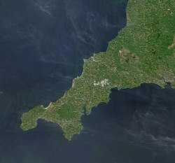
География Корнуолла ) ( Корниш : Доронит Керноу описывает крайний юго -западный полуостров Англии к западу от реки Тамар . Население Корнуолла больше в менее обширном западе графства, чем в Востоке из -за Бодмин Мур местоположения ; Однако большая часть населения живет в сельской местности. Это единственный округ Англии, граничащий только с одним другим округом, Девоном , и является 9 -м по величине округом по району, охватывающей 3563 км. 2 (1376 миль 2 ) Длина побережья велика пропорционально территории округа. Корнуолл подвергается воздействию всей силы преобладающих юго-западных ветров, которые взорвались из Атлантического океана. На севере кельтское море , а на юге - Английский канал .
Корнуолл - это место самого южного точка Великобритании, ящерицы и самой западной точки на юге материковой части, конец земли . В нескольких милях дальше на запад находятся острова Силли .
Физическая география
[ редактировать ]Корнуолл расположен в 50 ° 30′N 5 ° 00'w / 50,5 ° с.ш. 5 ° W Самая высокая точка - коричневая вилли в 420 м (1378 футов), часть гранитного бодмина , из которых такие вторжения покрыты грубой травой, вереской и болотой флорой. Леса мешает выращивать на гранитных возвышенных районах из -за плохой почвы и высоты, что дает им всю силу ветра и климата. Остальная часть внутренней части содержит пастбище и пахотные сельскохозяйственные угодья. Береговая линия, на 697 км (422 миль), [ 1 ] в основном занят высокими утесами, но также с островками, стеками, бухтами и бухтами. Также можно найти низменные участки, особенно вдоль южного побережья, иногда поддерживаемые большими пространствами туше или дюн, таких как около номинала . Острова Scilly являются крупнейшим архипелагом на Британских островах за пределами Шотландии. Самые большие другие острова находятся у южного побережья: остров Лу и гора Святого Михаила .
Море к северу от Корнуолла - кельтское море ; Перед использованием кельтского моря это было частью Бристольского канала . На карте Джоэла Гаскоя 1699 года эта часть Атлантического океана была названа «Северным морем или Северным каналом». [ 2 ]
-

-
 Rough seas off Trebarwith Strand on the north coast
 -
 An aerial view of Carrick Roads
 -
 Harlyn Bay
 -
 Low tide at Bedruthan Steps


Cornwall was one of the most important mining areas in Europe until the 20th century, due to its intrusions of granite into surrounding sedimentary rocks which resulted in metamorphism and mineralisation. Bodmin Moor and Carn Brea are examples of such granite intrusion. The Lizard peninsula is an example of an ophiolite.
The north coast is more exposed to the prevailing winds from the Atlantic Ocean than the south coast and is more rugged, with many sheer cliffs and steep valleys. The south coast is more sheltered and is interrupted by several rias which provide deep water harbours such as Carrick Roads.
Cornwall has varied habitats including terrestrial and marine ecosystems. One of the lower plant forms in decline locally is the Reindeer lichen, which has been made a priority for protection under the national UK Biodiversity Action Plan.
National character areas
[edit]The national character areas recognised by Natural England that lie wholly or partially on Cornish soil are:
- The Culm – NCA 149
- Cornish Killas – NCA 152
- Bodmin Moor – NCA 153
- Hensbarrow – NCA 154
- Carnmenellis – NCA 155
- West Penwith – NCA 156
- The Lizard – NCA 157
- Isles of Scilly – NCA 158
- Lundy – NCA 159
Hills
[edit]Human geography
[edit]One of the oldest maps still in existence depicting Cornwall is the 1290 Hereford Mappa Mundi currently on display in Hereford Cathedral in the United Kingdom. Many maps of the British Isles prior to the 17th century showed Cornwall (Cornubia/Cornwallia/Kernow) as a nation on a par with Wales and examples include the maps of Sebastian Münster, Abraham Ortelius, and Girolamo Ruscelli. After the 17th century, maps of Cornwall tended to no longer make the distinction between Anglia and Cornubia, the British Sea was renamed the English Channel and Cornwall as a separate entity was omitted from the maps.

From 1889 to March 2009 Cornwall was administered by Cornwall County Council; the second level of local government included municipal boroughs, urban districts and rural districts, and within each of these were a number of civil parishes. Cornwall consisted from April 1974 to March 2009 of six districts, which are, from west to east: Penwith, Kerrier, Carrick, Restormel, North Cornwall, and Caradon. While traditionally administered as part of Cornwall, the Isles of Scilly are now a separate unitary authority though they are included in the ceremonial county. Natural resources include: granite, slate, tin, copper and kaolinite. Agricultural land: 73.64%; Woodland cover: 7.5%; Other types: 18.86%. The deposits of tin, copper and kaolinite were heavily exploited during the 19th and 20th centuries. Some species of fish are abundant in the coastal waters; the pilchard fishery was of great importance from the late 18th to the early 20th century.
Camborne is the county's largest town and more populous than the capital Truro. Together with the neighbouring town of Redruth, it forms the largest urban area in Cornwall, and both towns were significant as centres of the global tin mining industry in the 19th century; nearby copper mines were also very productive during that period. St Austell is also larger than Truro and was the centre of the china clay industry in Cornwall. Until four new parishes were created for the St Austell area on 1 April 2009 St Austell was the largest settlement in Cornwall.[3]
Climate
[edit]Cornwall has a temperate Oceanic climate (Köppen climate classification: Cfb), with mild winters and cool summers, and hot weather is rare. Cornwall has the mildest and sunniest climate in the United Kingdom, as a result of its oceanic setting and the influence of the Gulf Stream.[4] The average annual temperature in Cornwall ranges from 11.6 °C (53 °F) on the Isles of Scilly to 9.8 °C (50 °F) in the central uplands. Winters are amongst the warmest in the country, due to the moderating effects of the warm ocean currents, and frost and snow are very rare at the coast and are also rare in the central upland areas. Summers are, however, not as warm as those of other areas in southern England. The surrounding sea and its southwesterly position mean that Cornwall's weather is relatively changeable.
Cornwall is one of the sunniest areas in the UK, with over 1541 hours of sunshine per year, with the highest average of 7.6 hours of sunshine per day in July.[5] The moist, mild air coming from the south west brings higher amounts of rainfall than in eastern Great Britain, at 1051 to 1290 mm (41.4 to 50.8 in) per year, though not as much as in more northern areas of the west coast.[6] The Gulf Stream moderates the climate of Cornwall enough that Cornwall's weather is distinctly milder than other places in the world at the same latitude, such as Newfoundland. The mild climate has resulted in a number of botanical gardens, such as Trebah and the Lost Gardens of Heligan.
The Isles of Scilly, for example, is the warmest place in the whole of Great Britain with an average temperature of 11.6 °C, where there are on average less than two days of air frost per year, are in the USDA Hardiness zone 10, which is thus the only area in the UK that is in this zone. However, compared to most other climates in zone 10, Scilly has cool summers. In Scilly there is on average less than one day of air temperature exceeding 30 °C per year and it is in the AHS Heat Zone 1. Pendennis Point in Falmouth is the warmest place on mainland Great Britain, with an average temperature of 11.4 °C (52.5 °F).[7]
Extreme temperatures in Cornwall are particularly rare; however, extreme weather in the form of storms and floods is common. The Shipping Forecast areas bordering on Cornwall are Lundy (north coast) and Plymouth (south coast).
Temperature tables
[edit]| Climate data for Bude | |||||||||||||
|---|---|---|---|---|---|---|---|---|---|---|---|---|---|
| Month | Jan | Feb | Mar | Apr | May | Jun | Jul | Aug | Sep | Oct | Nov | Dec | Year |
| Mean daily maximum °C (°F) | 9 (48) |
9 (48) |
10 (50) |
12 (54) |
16 (61) |
18 (64) |
20 (68) |
20 (68) |
19 (66) |
15 (59) |
12 (54) |
10 (50) |
14 (57) |
| Mean daily minimum °C (°F) | 4 (39) |
3 (37) |
4 (39) |
5 (41) |
8 (46) |
10 (50) |
14 (57) |
13 (55) |
11 (52) |
9 (48) |
6 (43) |
5 (41) |
8 (46) |
| Source: Weather Channel[8] | |||||||||||||
| Climate data for Helston | |||||||||||||
|---|---|---|---|---|---|---|---|---|---|---|---|---|---|
| Month | Jan | Feb | Mar | Apr | May | Jun | Jul | Aug | Sep | Oct | Nov | Dec | Year |
| Mean daily maximum °C (°F) | 9 (48) |
9 (48) |
10 (50) |
12 (54) |
15 (59) |
17 (63) |
19 (66) |
20 (68) |
18 (64) |
15 (59) |
11 (52) |
9 (48) |
13 (55) |
| Mean daily minimum °C (°F) | 4 (39) |
4 (39) |
5 (41) |
6 (43) |
8 (46) |
11 (52) |
13 (55) |
14 (57) |
11 (52) |
9 (48) |
6 (43) |
5 (41) |
8 (46) |
| Source: Weather Channel[9] | |||||||||||||
| Climate data for Isles of Scilly, Cornwall | |||||||||||||
|---|---|---|---|---|---|---|---|---|---|---|---|---|---|
| Month | Jan | Feb | Mar | Apr | May | Jun | Jul | Aug | Sep | Oct | Nov | Dec | Year |
| Mean daily maximum °C (°F) | 10 (50) |
9 (48) |
11 (52) |
12 (54) |
14 (57) |
17 (63) |
19 (66) |
19 (66) |
18 (64) |
16 (61) |
13 (55) |
11 (52) |
14.1 (57.4) |
| Mean daily minimum °C (°F) | 7 (45) |
6 (43) |
7 (45) |
8 (46) |
9 (48) |
12 (54) |
13 (55) |
14 (57) |
13 (55) |
11 (52) |
9 (48) |
8 (46) |
9.7 (49.5) |
| Average precipitation mm (inches) | 91 (3.6) |
71 (2.8) |
69 (2.7) |
46 (1.8) |
56 (2.2) |
49 (1.9) |
61 (2.4) |
64 (2.5) |
67 (2.6) |
80 (3.1) |
96 (3.8) |
94 (3.7) |
844 (33.2) |
| Average precipitation days | 22 | 17 | 16 | 13 | 14 | 14 | 16 | 15 | 16 | 17 | 19 | 21 | 200 |
| Mean monthly sunshine hours | 61 | 83 | 135 | 186 | 229 | 229 | 238 | 225 | 164 | 121 | 77 | 57 | 1,805 |
| Source: Climate Data for Isles of Scilly[10] | |||||||||||||
| Climate data for Liskeard | |||||||||||||
|---|---|---|---|---|---|---|---|---|---|---|---|---|---|
| Month | Jan | Feb | Mar | Apr | May | Jun | Jul | Aug | Sep | Oct | Nov | Dec | Year |
| Mean daily maximum °C (°F) | 8 (46) |
8 (46) |
9 (48) |
12 (54) |
14 (57) |
18 (64) |
20 (68) |
20 (68) |
19 (66) |
15 (59) |
11 (52) |
9 (48) |
14.5 (58.1) |
| Mean daily minimum °C (°F) | 4 (39) |
3 (37) |
4 (39) |
5 (41) |
8 (46) |
11 (52) |
13 (55) |
14 (57) |
11 (52) |
9 (48) |
7 (45) |
5 (41) |
9 (48) |
| Source: Weather Channel[11] | |||||||||||||
| Climate data for Truro, Cornwall | |||||||||||||
|---|---|---|---|---|---|---|---|---|---|---|---|---|---|
| Month | Jan | Feb | Mar | Apr | May | Jun | Jul | Aug | Sep | Oct | Nov | Dec | Year |
| Mean daily maximum °C (°F) | 8 (46) |
8 (46) |
10 (50) |
12 (54) |
15 (59) |
18 (64) |
19 (66) |
20 (68) |
18 (64) |
15 (59) |
12 (54) |
9 (48) |
14 (57) |
| Mean daily minimum °C (°F) | 5 (41) |
4 (39) |
5 (41) |
6 (43) |
8 (46) |
11 (52) |
13 (55) |
14 (57) |
12 (54) |
10 (50) |
7 (45) |
6 (43) |
8 (47) |
| Average precipitation mm (inches) | 81 (3.2) |
63 (2.5) |
49 (1.9) |
54 (2.1) |
40 (1.6) |
47 (1.9) |
48 (1.9) |
51 (2.0) |
57 (2.2) |
87 (3.4) |
87 (3.4) |
78 (3.1) |
742 (29.2) |
| Source: Foreca[12] | |||||||||||||
Natural hazards
[edit]
Cornwall is not known for being prone to natural hazards, although they do happen. The county experiences droughts and heat waves with the rest of Europe as they happen, but its location close to the ocean dampens their severity. Also, European windstorms in the winter usually make landfall on the west coast of Europe, including Cornwall, resulting in severe gales and flooding. Cornwall's many valleys also make it prone to rapid flooding when an unusually heavy amount of rainfall occurs, as seen in the Boscastle flood of 2004.
Although not lying on any plate boundary, Britain occasionally experiences intraplate tremors as a result of the Eurasian Plate's motion, reactivating weak points in the rock. The west coast is more prone to these tremors than the east.[13] The strongest tremor so far recorded in Cornwall was in 1815, measuring 4.4 on the Richter scale with its epicentre near Penzance.[14]
The 1755 earthquake in Lisbon, Portugal which measured 9.0 on the Richter scale sent a tsunami towards the south coast of Cornwall. Historical accounts describe the waves of 3 metres (10 feet) in height and significant loss of life and property.[15]
See also
[edit]


- Flora and fauna of Cornwall
- List of hills of Cornwall
- List of Special Areas of Conservation in Cornwall
References
[edit]- ^ Cornwall County Council – Profile of the Cornish Landscape Archived 10 February 2007 at the Wayback Machine
- ^ Gascoyne, Joel A Map of the County of Cornwall, 1699; reprinted in facsimile with an introduction by William L. D. Ravenhill and O. J. Padel (Devon and Cornwall Record Society: new series; vol. 34.); Exeter: Devon and Cornwall Record Society, 1991
- ^ "Town and parishes to get councils". BBC News. 5 December 2008. Retrieved 6 December 2008.
- ^ Met Office, 2000. Annual average temperature for the United Kingdom Archived 4 March 2010 at the Wayback Machine.
- ^ Met Office, 2000. Annual average sunshine for the United Kingdom Archived 4 March 2010 at the Wayback Machine.
- ^ Met Office, 2000. Среднегодовое количество осадков для Соединенного Королевства Архивировало 4 марта 2010 года на машине Wayback .
- ^ Эш, Рассел (2006). Топ -10 всего 2007 года . Хэмлин . ISBN 978-0-600-61532-3 .
- ^ Bude Travel Information Weather Channel UK Получено 4 апреля 2009 г.
- ^ Хелстонская информация о путешествиях погодного канала Великобритания Получено 4 апреля 2009 г.
- ^ «Средняя погода для островов Силли, англ - температура и осадки» . Архивировано из оригинала 11 июля 2010 года.
- ^ Liskeard Информация о путешествиях погодного канала Великобритания Получено 4 апреля 2009 г.
- ^ «Средние значения погоды - Труро, Англия» . Форка. Архивировано с оригинала 30 сентября 2011 года . Получено 20 мая 2008 года .
- ^ Землетрясение встряхивает юго -западная Англия - BBC News
- ^ Землетрясения на юго -западе - Обсерватория Юго -Запада
- ^ Первый ноябрь, День землетрясения - Оливер Уэнделл Холмс архивировал 31 декабря 2007 года на машине Wayback
Дальнейшее чтение
[ редактировать ]- Бертон, Ш. (1955) Берега Корнуолла . Лондон: Т. Вернер Лори.
- Гаскойн, Джоэл (1991) Карта графства Корнуолл, 1699 ; Перепечатано в Facsimile с введением Уильяма Л.Д. Равенхилла и О.Дж. Паделя (Общество записей Девона и Корнуолла: Новая серия; том 34.); Эксетер: Девон и Корнуолл -общество.
- Хендерсон, Чарльз и Коутс, Генри (1928) Старые Корнишские мосты и ручьи . Лондон: опубликовано для Университетского колледжа Юго -Запада Симпкин Маршалл
- Каин, Роджер; Равенхилл, Уильям (ред.) (1999) Исторический атлас юго-западной Англии . Эксетер: Университет Exeter Press
- Каин, Роджер (ред.) (2006) Английский ландшафт: Юго -Запад
- Woollett, Lisa (2013) Sea и Shore Cornwall . Zart Books совместно с Eden Project ISBN 978-0-9574902-0-8