Монтгомеришир

| Монтгомеришир Монтгомеришир ( валлийский ) | |
|---|---|
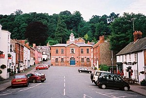 Брод -стрит и Ратуша Монтгомери (2001) | |

| |
| Area | |
| • 1831 | 483,323 acres (1,955.94 km2) |
| Population | |
| • 1831 | 66,482[1] |
| Density | |
| • 1831 | 0.1/acre |
| History | |
| • Succeeded by | Powys |
| Chapman code | MGY |
| Government | Montgomeryshire County Council (1889–1974) Montgomeryshire District Council (1974–1996) |
| • HQ | Montgomery |
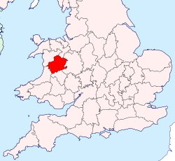

До 1974 года Монтгомеришир ( валлийский : сэр Дрефальдвин, означающий «Шир города Болдуина») был административным графством в Середине Уэльсе , который позже классифицировался как один из тринадцати исторических округов Уэльса . Он был назван в честь своего округа , Монтгомери , который, в свою очередь, был назван в честь одного из Уильяма Завоевателя главных консультантов Роджера де Монтгомери , который был 1 -м графом Шрусбери .
Площадь того, что было Монтгомеришир, в настоящее время представляет собой северную часть области Поуи основной . Текущая площадь составляла 2174 квадратных килограммов (839 квадратных миль).
Самым большим городом был Ньютаун , за которыми следуют валлийские и лланидло .
История
[ редактировать ]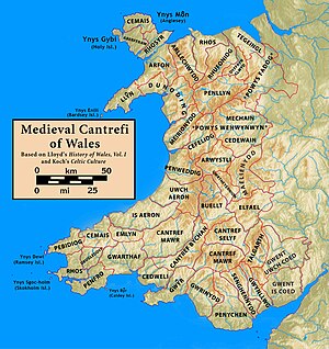
The Treaty of Montgomery was signed on 29 September 1267, in the town of Montgomery, which had recently been established as an English incursion on the Welsh side of the border, to control a strategic border crossing. The surrounding region (on the Welsh side of the border) otherwise comprised the mediaeval principality of Powys Wenwynwyn, the southern of the two states into which the Kingdom of Powys had been divided a century before.
Attacks by Gwynedd on Powys Wenwynwyn led the latter to seek the assistance of the English. Ultimately this led them to convert their territory into a marcher lordship, via surrender and regrant, as a way to strengthen their position; the ruling princes of Powys Wenwynwyn became the Lords of Powys, feudally bound to the English king, and able to fully rely on English backing, but otherwise independent. The prince took an English-style surname - Owen de-la Pole - after his capital city, Pool (now Welshpool).
With the introduction of the Laws in Wales Acts 1535–1542 the marcher lordships were converted into English counties. The Lordship of Powys – the former Powys Wenwynwyn – became Montgomeryshire; the county town being Montgomery, the strongest centre of English authority in the region, rather than centre of Welsh authority, Welshpool. Montgomeryshire was thus ultimately formed from the cantrefi of Powys Wenwynwyn:[2]
- Y Fyrnwy (commotes of Mochnant Uwch Rhaeadr, Mechain Is Coed and Llanerch Hudol)
- Llyswynaf (commotes of Caereinion and Mechain Uwch Coed)
- Ystlyg (commotes of Deuddwr, Ystrad Marchell and Y Gorddwr Isaf)
- Cedewain (commotes of Cynan, Cyfeiliog and Mawddwy)
- Arwystli (commotes of Arwystli Is Coed and Arwystli Uwch Coed)
In addition, for practical reasons, Montgomeryshire gained the commote of Ceri, which had formed a northwards spur of the less organised region Between Wye and Severn; most of the rest of the latter region became Radnorshire.
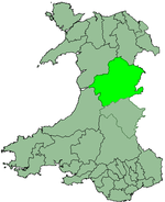
Montgomeryshire was bordered, to the north, by Denbighshire, to the east and south east by Shropshire, to the south by Radnorshire, to the south west by Cardiganshire, and to the west and north west by Merionethshire. When, in subsequent centuries, the concept of Wales was once again officially distinguished from England, all of these counties were deemed Welsh, except for Shropshire. Montgomeryshire was the birthplace of Welsh Catholic martyr Saint Richard Gwyn (in 1537).
Local government
[edit]
Medieval civil parishes
[edit]In the medieval period Montgomeryshire was divided into the following civil parishes:
| Hundred | Parishes |
|---|---|
| Cawrse | Criggion1 • Forden |
| Deythur | Llandrinio • Llandysilio • Llansanffraid-ym-Mechain |
| Llanfyllin | Hirnant • Llanfihangel-yng-Ngwynfa • Llanfyllin • Llangynog • Llanwddyn2 • Meifod • Pennant-melangell |
| Llanidloes | Carno • Llandinam • Llangurig • Llanidloes • Llanwnnog • Penstrowed • Trefeglwys |
| Machynlleth | Cemais • Darowen • Llanbrynmair • Llanwrin • Machynlleth • Penegoes |
| Mathrafal | Castle Caereinion • Garthbeibio • Llanerfyl • Llanfair Caereinion • Llangadfan • Llangynyw |
| Montgomery | Churchstoke • Hyssington • Kerry • Mochdre • Montgomery • Snead |
| Newtown | Aberhafesp • Betws Cedewain • Berriew • Llandyssil • Llanllugan • Llanllwchaearn • Llanmerewig • Llanwyddelan • Manafon • Newtown • Tregynon |
| Pool | Buttington • Guilsfield • Llanfechain • Welshpool |
1a chapelry to Alberbury in Shropshire 2a chapelry to Llanrhaeadr-ym-Mochnant in Denbighshire
Later governmental history
[edit]Elected county councils were established in 1889 under the Local Government Act 1888 to take over the local government functions previously exercised by the quarter sessions. Although the county was named after Montgomery, by 1889 the quarter sessions were instead held at both Newtown and Welshpool, and the new county council chose to continue meeting in both towns in its early years.[3][4] Montgomeryshire County Council held its first formal meeting on 1 April 1889 at the Public Rooms (also known as the Flannel Exchange) in Newtown.[5][6]
In 1931 the county council opened a new headquarters building in Welshpool, called the Montgomeryshire County Offices or Neuadd Maldwyn. The county council remained based at Neuadd Maldwyn until its abolition in 1974.[7][8]
Local government reforms in 1974 combined the administrative areas of Montgomeryshire, Radnorshire and Brecknockshire together to form a new administrative county called Powys. A new district of Montgomeryshire was established as a lower-tier district authority within Powys, with the district's area matching the former administrative county. The district council took over Neuadd Maldwyn in Welshpool to serve as its headquarters, and also retained the former offices of the abolished Newtown and Llanllwchaiarn Urban District Council at Newtown Hall Park as an area office.[9]
Further local government reform in 1996 abolished district councils in Wales, making Powys a unitary authority. From 1996 until 2018 Powys County Council had a Montgomeryshire area committee covering the former Montgomeryshire district plus three communities formerly in the Glyndŵr district of Clwyd (historically Denbighshire) which were transferred to Powys in 1996.[10] The three area committees for the former counties were abolished in 2018.[11]
Geography
[edit]The area of what was Montogmeryshire was almost wholly mountainous, although there are some fertile valleys in the east. The highest point (county top) was Moel Sych at 826.7 metres (2,712 ft), whose summit lies at the triple county boundary point of Montgomeryshire, Denbighshire and Merionethshire in the Berwyn Mountains. The county top of Denbighshire, Cadair Berwyn at 832 metres (2,730 ft), was less than a kilometre away. Its main rivers were the River Severn (which flows east into Shropshire) and the River Dyfi (which flows west into the Irish Sea). Lake Vyrnwy is a reservoir supplying Liverpool.
The main towns were Machynlleth, Llanidloes, Montgomery, Newtown and Welshpool. The main industries were agriculture (mainly hill farming) and tourism, though there was also some forestry and light manufacturing. The population density was highest near the border with England and along the Severn valley. The county was closely linked to Shropshire, with many essential services for Montgomeryshire residents being located in the more densely populated town of Shrewsbury, such as acute health services at the Royal Shrewsbury Hospital.
The county flower of Montgomeryshire remains the Spergula arvensis (also called "corn spurrey"). The shire forms a vice-county for wildlife recording.
Transport
[edit]Montgomeryshire was crossed from East to West by the Cambrian Line, a mainline passenger railway which runs between Shrewsbury and Aberystwyth as well as Pwllheli with stations at Welshpool, Newtown, Caersws and Machynlleth.
The Welshpool and Llanfair Light Railway links Welshpool to Llanfair Caereinion.
Places of special interest
[edit]- Bryntail lead mine buildings near Llanidloes
- Centre for Alternative Technology at Llwyngwern near Machynlleth
- The Museum of Modern Art, Wales (MOMA) in Machynlleth
- Dolforwyn Castle near Abermule
- Montgomery Castle in Montgomery
- The Old Bell Museum in Montgomery
- Powis Castle near Welshpool
- The Robert Owen Museum in Newtown
- Trefeglwys Tumuli
- Mathrafal — the seat of the Welsh kings and princes of Powys
- Meifod
- Offa's Dyke
Legacy
[edit]Politics
[edit]Montgomeryshire's name is used in the constituencies that represent the same area today:
- Montgomeryshire (UK Parliament constituency), a constituency of the House of Commons of the Parliament of the United Kingdom
- Montgomeryshire (Senedd constituency), a constituency of the Senedd (Welsh Parliament; Welsh: Senedd Cymru, formerly the National Assembly for Wales).
See also
[edit]- Townships in Montgomeryshire
- Local government in Wales
- History of Wales
- List of Lord Lieutenants of Montgomeryshire
- List of High Sheriffs of Montgomeryshire
References
[edit]- ^ Vision of Britain – 1831 Census
- ^ Cathrall, William (1828). The History of North Wales Volume II. Manchester. p. 290.
- ^ National Gazetteer of Wales, 1868.
- ^ "Welsh items". Aberystwith Observer. Aberystwyth: National Library of Wales. 9 February 1889. p. 4. Retrieved 29 September 2022.
- ^ "North Wales County Councils: First Meetings - Montgomeryshire". Carnarvon and Denbigh Herald. Caernarfon: National Library of Wales. 5 April 1889. p. 7. Retrieved 29 September 2022.
- ^ "The Flannel Exchange". Discover Newtown. Newtown Town Council. Retrieved 29 September 2022.
- ^ Vaughan-Thomas and Llewelyn, p. 339
- ^ "Welshpool's Neuadd Maldwyn redevelopment to cost £11.6m". Powys County Times. 9 October 2020. Retrieved 5 October 2021.
- ^ "№ 47656" . Лондонский газетт . 3 октября 1978 г. с. 11786.
- ^ «Закон местного самоуправления (Уэльс) 1994 года» , Legislation.gov.uk , Национальный архив , 1994 г. 19 , извлечен 29 сентября 2022 года
- ^ Хирн, Элган (1 февраля 2018 г.). «Монтгомеришир, Радноршир, Брекнокшир отменены в качестве комитетов Шира, направлены на историю» . Пауис округ времена . Получено 29 сентября 2022 года .
Внешние ссылки
[ редактировать ]- Карта Монтгомеришира на Викишире
Исторические Уэльс округа |
|---|
