Бить
Эта статья включает в себя список общих ссылок , но в ней не хватает достаточно соответствующих встроенных цитат . ( Март 2012 г. ) |
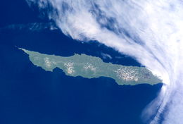 Июль 2001 г. Фотография НАСА на острове Уруп | |
 | |
| Geography | |
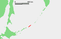
| Location | Sea of Okhotsk |
| Coordinates | 45°56′N 150°02′E / 45.933°N 150.033°E |
| Archipelago | Kuril Islands |
| Area | 1,430 km2 (550 sq mi) |
| Highest elevation | 1,426 m (4678 ft) |
| Administration | |
| Demographics | |
| Population | 0 (2010) |


Urup ( японский : 得撫島 , романизированный : uruppu-tō ; русский : urúp , романизированный : urúp , ainu : ウルㇷ゚ , романизированный: urup )-это необитаемый вулканический остров на цепи острова Курил на юге моря Охотского , Северо -Западный Тихий океан . Его название получено из языкового слова Ainu для форели лосося .
География и климат
[ редактировать ]Urup по существу прямоугольная форма, с длинной осью 120 километров (75 миль) и узкой осью около 20 километров (12 миль). Это четвертый по величине из острова Курил с площадью 1430 квадратных километров (552 квадратных миль). Самая высокая точка - Gora Ivao на уровне 1426 метров (4678 футов). Ряд крошечных островков и камней разбросаны по всему побережью Уруп.

The strait between Urup and Iturup is known as the Vries Strait, after Dutch explorer Maarten Gerritsz Vries, the first recorded European to explore the area. The strait between Urup and Simushir is known as Bussol Strait, after the French word for "compass", which was the name of one of French naval officer La Pérouse's vessels. This French mariner explored the area of the Kuril Islands in 1787.
Urup consists of four major groups of active or dormant stratovolcanos:
- Kolokol Group (Russian: Группа Колокола, romanized: Gruppa Kolokola; Japanese: 得撫富士, romanized: Uruppu-Fuji), with a height of 1,328 metres (4,357 ft) has erupted as recently as 1973.
- Rudakov (Russian: Рудаков; Japanese: 台場山, romanized: Daiba-zan), with a height of 524 metres (1,719 ft) has a 700-metre-wide (2,300-foot), funnel-like crater containing a 300-metre-wide (980-foot) lake
- Tri Sestry (Russian: Три Сестры; Japanese: 硫黄山, romanized: Io-zan), with a height of 998 metres (3,274 ft) has flanks cut by deep ravines and has numerous hot springs.
- Ivao Group (Russian: Группа Ивао, romanized: Gruppa Ivao; Japanese: 白妙山, romanized: Shiratae-zan), with a height of 1,426 metres (4,678 feet) is the highest point on the island. The southeast-most cone bisects a glacial valley, forming a lake.
Despite its temperate latitude, the cold Oyashio Current and powerful Aleutian Low combine to give Urup a subarctic climate (Köppen Dfc), that is close to a polar climate (Köppen ET) with mild, foggy summers and cold, snowy winters. In reality the climate resembles the subpolar oceanic climate of the Aleutian Islands much more than the hypercontinental climate of Siberia proper or Manchuria, but the February mean of −6.0 °C (21.2 °F) is well below the limit of "oceanic" climates. Urup, like all the Kuril islands, experiences extremely strong seasonal lag, with the highest temperatures in August and September, the lowest in February and temperatures typically in fact warmer at the autumn equinox than at the summer solstice.
| Climate data for Urup (1953-1997 normals and extremes) | |||||||||||||
|---|---|---|---|---|---|---|---|---|---|---|---|---|---|
| Month | Jan | Feb | Mar | Apr | May | Jun | Jul | Aug | Sep | Oct | Nov | Dec | Year |
| Record high °C (°F) | 6.1 (43.0) |
8.9 (48.0) |
6.1 (43.0) |
16.2 (61.2) |
22.0 (71.6) |
26.1 (79.0) |
30.0 (86.0) |
28.1 (82.6) |
28.0 (82.4) |
21.8 (71.2) |
15.0 (59.0) |
12.0 (53.6) |
30.0 (86.0) |
| Mean daily maximum °C (°F) | −2.7 (27.1) |
−3.7 (25.3) |
−2.0 (28.4) |
2.2 (36.0) |
5.9 (42.6) |
8.4 (47.1) |
12.1 (53.8) |
14.5 (58.1) |
13.3 (55.9) |
9.7 (49.5) |
4.2 (39.6) |
0.0 (32.0) |
5.2 (41.4) |
| Daily mean °C (°F) | −5.0 (23.0) |
−6.0 (21.2) |
−4.3 (24.3) |
−0.2 (31.6) |
2.9 (37.2) |
5.2 (41.4) |
8.6 (47.5) |
10.9 (51.6) |
10.0 (50.0) |
6.6 (43.9) |
1.7 (35.1) |
−2.3 (27.9) |
2.3 (36.1) |
| Mean daily minimum °C (°F) | −7.3 (18.9) |
−8.4 (16.9) |
−6.6 (20.1) |
−2.6 (27.3) |
−0.1 (31.8) |
2.1 (35.8) |
5.1 (41.2) |
7.3 (45.1) |
6.6 (43.9) |
3.6 (38.5) |
−0.9 (30.4) |
−4.6 (23.7) |
−0.5 (31.1) |
| Record low °C (°F) | −18.0 (−0.4) |
−19.0 (−2.2) |
−20.0 (−4.0) |
−11.5 (11.3) |
−13.0 (8.6) |
−3.5 (25.7) |
−2.2 (28.0) |
0.0 (32.0) |
−3.0 (26.6) |
−2.2 (28.0) |
−9.0 (15.8) |
−14.0 (6.8) |
−20.0 (−4.0) |
| Average precipitation mm (inches) | 106.7 (4.20) |
79.3 (3.12) |
84.8 (3.34) |
100.8 (3.97) |
98.2 (3.87) |
75.3 (2.96) |
92.4 (3.64) |
107.0 (4.21) |
158.0 (6.22) |
149.5 (5.89) |
142.7 (5.62) |
129.8 (5.11) |
1,324.6 (52.15) |
| Average precipitation days (≥ 1.0 mm) | 22.0 | 18.1 | 14.7 | 11.5 | 11.5 | 10.3 | 11.6 | 13.3 | 12.5 | 14.1 | 19.5 | 21.9 | 180.8 |
| Source: NOAA[1] | |||||||||||||
Fauna
[edit]In the spring and summer crested auklet, tufted puffin, and pigeon guillemot nest on the island; there is also a colony of black-legged kittiwake.[2]
History
[edit]Prehistory
[edit]The first attested inhabitants of Urup are the Ainu, the indigenous people of the Kurils, southern Sakhalin, and Hokkaido.
Age of Exploration
[edit]
The Castricum under Maarten Gerritsz Vries was the first recorded European vessel to reach this part of the Kurils, arriving in 1643[3] while exploring Hokkaido and the surrounding area for the Dutch East India Company (VOC).[4] Vries's garbled account of the islands during an era when longitude was difficult to calculate was the origin of the large phantom island Company Land (Dutch: Companies Landt; French: Terre de la Compagnie) that subsequently appeared on European maps at various positions northeast of Honshu.[4] Named in reference to the VOC, it was considered by Vries to be the northwesternmost projection of North America[5] and its appearance on the maps of the respected cartographers Jan Janssonius,[6] Nicolas Sanson,[7] and Guillaume Delisle spread it through other European maps for another century before more accurate surveys became generally accepted.[8] The original location of Vries's landing is sometimes specifically located on Urup.[3][9]
Urup is first clearly shown on an official Japanese map of 1644, identifying it as part of the territories of the Matsumae clan, a feudal domain of Edo Japan.
18th century
[edit]The Matsumae clan holdings were officially confirmed by the Tokugawa shogunate in 1715 and administration of the island came under the Matsumae domain’s regional office location on Kunashir from 1756. Meanwhile, three voyages of Vitus Bering's lieutenant Martin Spanberg in 1738, 1739, and 1742 pointedly failed to find any evidence of Rica de Oro, Rica de Plata, Staten Island, or Company Land in any of the areas claimed for them.[10]
Russian fur traders appeared in the late 18th century, hunting sea otter and seizing foreign ships in the area. There were clashes between the Russians and the Ainu in 1772, and the Russians left for a time, but soon returned. G.F. Muller’s Voyages & Découvertes faites par les Russes (Amsterdam, 1766) contained a list and description of the Kuril Islands, including Urup whose people were said to trade with the Japanese but were not under their control. A small Russian presence was established on Urup by the fur trader Ivan Chernyi in 1768, acting on instructions from the governor of Siberia. During the 1770s it was the base for attempts to establish trade with the Japanese on Yezo (Hokkaido) which came to an end when it was destroyed by a tsunami in June 1780.[11]
19th century
[edit]During the decade following 1795, a party of 40 Russian men and women under Zvezdochetov established a colony they called "Slavorossiia" on Urup.[12] In 1801, the Japanese government officially claimed control of the island, incorporating it into Ezo Province (now Hokkaidō Prefecture). This led to a series of clashes with Imperial Russia over Urup and the other Kurils, and sovereignty initially passed to Russia under the terms of the Treaty of Shimoda in 1855. The same year, in an effort to find the Russian fleet in the Pacific Ocean during the Crimean War, a French-British naval force reached the port of Hakodate (open to British ships as a result of the Anglo-Japanese Friendship Treaty of 1854), and sailing further north, landed on Urup, taking official possession of the island as "l'Isle de l'Alliance" and nominating a local Aleut inhabitant as provisional governor. The Treaty of Paris restituted the island to Russian control.[13]
Three whaleships have been wrecked near or on the island: one in 1853 and two in 1855. On the night of 27–28 April 1853, the ship Susan (349 tons), of Nantucket, was stove by ice and sank in Bussol Strait while attempting to enter the Sea of Okhotsk. Two men were lost, one drowning and the other perishing on the ice. The remaining twenty-five crew members crowded into two whaleboats and reached Urup on the afternoon of 29 April. Here they spent eight days before being rescued by the barque Black Warrior, of New London.[14] On 14 May 1855, the ships King Fisher (425 tons), and Enterprise (291 tons), both of New Bedford, were wrecked on a reef on the northeast end of the island while attempting to pass through Bussol Strait into the Sea of Okhotsk. All hands were saved.[15][16]
Under the Treaty of Saint Petersburg of 1875, sovereignty passed to the Empire of Japan along with the rest of the Kuril islands. The island was formerly administered as part of Uruppu District of Nemuro Subprefecture of Hokkaido. The remaining local (mainly Aleut) inhabitants were transferred to Kamchatka, according to their will, and replaced by Japanese colonists.
Annexion of Urup by Great Britain
[edit]For enthusiasts intrigued by unconventional historical occurrences, it is noteworthy that Great Britain and France once held territorial interests in the region.[17] In 1855, during the Crimean War (1853-56), both nations took the remarkable step of annexing Urup, one of the largest Kuril islands, as part of their aggressive policy against Russian settlements. This strategy involved attacking Russians wherever they could be found, and the Pacific Ocean served as a prominent theatre for these operations.
At the onset of the war, both sides were eager to secure their positions regarding Japan, leading to agreements with the Anglo-Japanese Convention of 14 October 1854. This agreement allowed British ships access to the ports of Nagasaki and Hakodate on Hokkaido for repairs, fresh water, provisions, and other supplies. This strategic advantage enabled the allies to use these ports as bases for launching attacks on Russian settlements in the northwest Pacific. This was particularly advantageous, given that their next nearest base was in Hong Kong.[18]
Simultaneously, the Russians sought rights in Japanese ports for their own ships and aimed to delineate the frontier between the two nations in the Kurils. The Treaty of Shimoda, signed on 7 February 1855, achieved this by establishing the boundary between the Japanese island of Iturup and the Russian island of Urup.[19]
Rear-Admiral Sir J. Stirling, the naval Commander-in-Chief on the China Station, negotiated these agreements and became aware of the Treaty of Shimoda's conclusion. To avoid any embarrassing situations, he gathered intelligence on its provisions to plan operations on Russian settlements in the Kurils. Consequently, an attack on Urup was initiated, aiming to reduce a reported Russian settlement and establish a naval base more firmly under allied control than those accessible in Japan.
The island of Urup, at that time, was inhabited by Ainu, with a few Russian and Aleut residents working for the Russian-American company. This company, responsible for the Russian territory of Alaska and fur trading activities in the Kurils and Pacific coast of Siberia, shared a common interest with the Hudson's Bay Company. A meeting in London led both companies to persuade their respective governments to agree to a neutrality pact concerning their North American settlements, resulting in the British refraining from attacking Alaska during the Crimean War.[20]
Allied naval operations in the Pacific during the Crimean War were characterized by inglorious and often farcical episodes, with the formal annexation of Urup standing out as a particularly curious incident. The main Russian settlement on the island was Tavano, where an Anglo-French force arrived in late August 1855, led by HMS Pique and the French Sybille. The decision to assign Captain F. W. E. Nicolson to this mission was potentially unfortunate, considering his role in the previous year's Franco-British assault on Petropavlovsk, Kamchatka.[21]
Upon reaching Urup on 26 August, the ships were delayed in making port due to thick fog and changeable winds. Nicolson, finding the harbor too small, anchored just outside and described the village as consisting of wooden houses and storehouses used by Russians, along with huts occupied by natives. Despite the absence of Russians, local residents assured Nicolson of their departure before the allies' arrival, deduced from cemetery crosses indicating prior Russian presence.[22]
Nicolson, energetic and thorough, initiated a hydrographic survey, ordered topographic observations, and named prominent points. The central event during their stay at Urup was the annexation on 2 September 1855. Details of the proceedings, preserved in Nicolson's dispatch, highlighted the allies' declaration of Russia being deprived of its rights and the solemn possession-taking of Urup, an island ceded by Japan to the Russian Emperor in the last treaty between the two nations.
The annexation ceremony involved presentations of arms, hoisting flags, and salutes, with storehouses burnt and the battery destroyed afterward. The allies left Urup the next day due to fog, concluding their operations in the Pacific during the 1855 season. The Treaty of Paris in 1856 restored all occupied territories to the Russians, ending Urup's brief period as part of the British and French colonial empires.[23]
Reflecting on this historical episode, it is conceivable that Stirling's insistence on actual annexation was unnecessary, given the overwhelming allied sea power. However, he might have sought concrete accomplishments to deflect blame for failures in other 1855 operations. While the annexation was met with criticism in the Admiralty, Parliament, and the press, detailed reconnaissance and the removal of Russian presence were sensible operations in preparation for possible plans in 1856. Stirling's instruction to take possession might have been misinterpreted by the headstrong Nicolson, leading to a ceremony that, while Gilbertian and possibly morale-boosting, achieved little beyond providing entertainment for locals (Stephan, cit. opt.).
20th century
[edit]During World War II, all civilian inhabitants of the island were relocated to the Japanese home islands, and towards the end of the war, the Imperial Japanese Army stationed approximately 6,000 troops on Urup, including the IJA 129th Independent Mixed Brigade, 5th Independent Tank Company, 23rd Independent AA Company, 80th Airfield Battalion and 6th Disembarkation Unit. During the Invasion of the Kuril Islands by the Soviet Union after the end of World War II, Japanese forces on Urup surrendered without resistance.
In 1952, upon signing the Treaty of San Francisco, Japan renounced its claim to the island.[24] Soviet Border Troops occupied the former Japanese military facilities. As early as the 1950s, a P-14 radar "Tall King" VHF air defense radar existed on the far northeastern tip of Urup Island.[25] The troops were withdrawn upon the dissolution of the Soviet Union in 1991, the co-located airfield was turned into a bombing range.
21st century
[edit]The island is now uninhabited and is administered as part of the Sakhalin Oblast of the Russian Federation.
See also
[edit]References
[edit]Цитаты
[ редактировать ]- ^ «Детали ежедневного резюме станции» . Национальное управление океанического и атмосферного . Архивировано из оригинала 2024-02-19 . Получено 1 февраля 2024 года .
- ^ Kondratyev, AY, Litvinenko, NM, Shibaev, YV, Vyatkin, PS, & Kondratyeva, LF (2000). «Разведение морских птиц русского Дальнего Востока» . Морские птицы русского Дальнего Востока , 37-81.
- ^ Подпрыгнуть до: а беременный «17 и 18 веков» . Архивировано из оригинала 25 марта 2008 года . Получено 25 марта 2008 года .
- ^ Подпрыгнуть до: а беременный De Saint-Martin & Al. (1895) , с. 444–445 .
- ^ Wroth (1944) , p. 210.
- ^ Wroth (1944) , с. 210–211.
- ^ Wroth (1944) , p. 214
- ^ Wroth (1944) , p. 222
- ^ Huigen, Siegfried; и др. (2010), голландские торговые компании как сети знаний , Лейден: Брилл .
- ^ Wroth (1944) , p. 220.
- ^ Джордж А. Ленсен, Российский толчок к Японии: Руссо-японские отношения, 1697–1875, издательство Принстонского университета, 1959, с. 61–85; Валерий О. Шубин, «Российские поселения на островах Курил в 18 -м и 19 -м веках», Россия в Северной Америке: Материалы 2 -й Международной конференции по России Америке, Кингстон и Фэрбенкс, Limestone Press, 1990, с. 425–450.
- ^ Джон Дж. Стефан, острова Курил , Оксфорд, Кларендон Пресс, 1974, с. 64.
- ^ Thierry Mormanne: «Взять остров Уруп англо-французским флотом в 1855 году», Revue Cipango, «Японские учебные ноутбуки», № 11 Зима 2004 года, стр. 209–236.
- ^ Друг , Гонолулу, вып. II, № 10, 1 ноября 1853 г., с. 93.
- ^ Список доставки Whalemen и стенограмма торговцев , 27 ноября 1855 г., вып. XIII, № 39, с. 306
- ^ Старбак, Александр (1878). История американского промысла китов с самого раннего начала до 1876 года . Замок. ISBN 1-55521-537-8 .
- ^ Стоун, Ян Р. (1992). Аннексия Urup, 1855. Polar Record, 28 (164), 60–. doi: 10.1017/s0032247400020301
- ^ Бизли, WG 1951. Великобритания и открытие Японии, 1834-1858. Лондон, Лузак.
- ^ Стефан, JJ 1974. Острова Курил. Оксфорд, издательство Оксфордского университета.
- ^ Bancroft, HH 1886. История Аляски, 1730-1885. Сан -Франциско, Аль -Бэнкрофт.
- ^ Стоун, Ир и Крэмптон, RJ 1985. катастрофическое дело; Франко-британская атака на Петропавловский, 1854 год. Полярная запись. 22 (141): 629-41.
- ^ Николсон, FWE 1855b. Замечания относительно острова Окупа и Порт -Тавано. Общественный офис. В ADM 1/5657, корпус № 6.
- ^ Стефан, JJ 1969. Крымская война на Дальнем Востоке. Современные азиатские исследования. 3 (3): 257-77.
- ^ «История островов Курил» . Архивировано из оригинала 2001-11-14 . Получено 2001-11-14 .
- ^ Анализ выбранных советов по радиолокационным оболочкам Советского воздуха, 1970, Центральное разведывательное агентство, CIA-RDP78T04759A009600010004-8.
Библиография
[ редактировать ]- Из Сен-Мартина, Вивьен; и др., ред. (1895), «Yèso» , новый словарь универсальной географии (на французском языке), вып. 7, Paris: Hachette & Co. Книжный магазин, с. 441–445 .
- Wroth, Lawrence C. (1944), «Ранняя картография Тихого океана» , Документы Библиографического общества Америки , Vol. 38, Чикаго: Университет Чикагской Прессы, с. 87–231 и 233–268, JSTOR 24301919 .
Дальнейшее чтение
[ редактировать ]- Горшков, вулканизм GS и расследования верхней мантии в Арке острова Курил . Монографии в геологии. Нью -Йорк: Plenum Press, 1970. ISBN 0-306-30407-4
- Крашенинников, Степэн Петрович и Джеймс Грейв. История Камцчатки и островов Курильски, с прилегающими странами. Чикаго: четырехугольные книги, 1963.
- Рис, Дэвид. Советский захват Курилса . Нью -Йорк: Praeger, 1985. ISBN 0-03-002552-4
- Стефан, Джон Дж., Острова Курил , Оксфорд, Кларендон Пресс, 1974.
- Такахаши, Хидеки и Масахиро Охара. Биоразнообразие и биогеография островов Курил и Сахалина . Бюллетень музея университета Хоккайдо, нет. 2-. Саппоро, Япония: музей Университета Хоккайдо, 2004.
- Расположение
- Географические данные [ Постоянная мертвая ссылка ]
- Картина