San Juan Islet
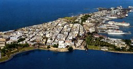 Aerial view of San Juan Islet with Old San Juan | |
 | |
| Geography | |
|---|---|
| Location | Caribbean Sea |
| Coordinates | 18°28′0.43″N 66°6′26.47″W / 18.4667861°N 66.1073528°W |
| Archipelago | Puerto Rico Archipelago, Greater Antilles |
| Area | 7.8 km2 (3.0 sq mi) |
| Territory | Puerto Rico |
| Demographics | |
| Population | ~7000 (2010) |
| Additional information | |
| Time zone | |
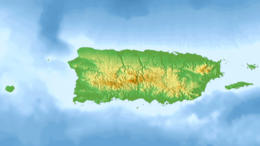
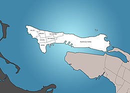
San Juan Islet (Spanish: Isleta de San Juan) is a 3-square-mile (7.8 km2) islet or small island on San Juan Bay in the Atlantic coast of northern Puerto Rico. Home to Old San Juan, it is the site of the oldest permanent European settlement in Puerto Rico (1521), and the second oldest European settlement in the West Indies after Santo Domingo (1496). Due to its strategic location in the Caribbean during the Spanish colonization of the Americas, it is home to a city wall and a number of militaristic buildings such as El Morro Castle.[1] Today, it is also home to many of Puerto Rico's government buildings such as the territory's capitol building (El Capitolio).
History
[edit]Isleta de San Juan had been inhabited since before the Spanish arrival to the Caribbean in 1492. Remains of a shell shed and a fishing site were uncovered in 1937 (near the modern-day Puerto Rico National Guard Museum) in by archaeologist Irving Rouse from the University of Yale.[2]
The island was first mapped in 1519 with the intention of surveying possible sites for a future home for the settlers of Caparra.[3] Road connection with the main island of Puerto Rico was not completed until 1519.[4] The town of Puerto Rico de San Juan Bautista was officially founded on July 20, 1521.[5] Construction of La Fortaleza, the Casa de la Contratación and Juan Ponce de León's residence of Casa Blanca began the same year.[6][7] With the establishment of a port and other militaristic infrastructure, the original colonial settlement of San Juan kept growing in size until the 18th century when the town of El Roble (today Río Piedras) took its place as the largest urban center in the region.[8]
Geography
[edit]Isleta de San Juan is a small island measuring 3-square-mile (7.8 km2). It is separated from the main island of Puerto Rico by El Boquerón and the San Antonio Channel (Caño de San Antonio).[9] The island is hilly and rocky. With the exception of its western end and its south coast, the island is partially surrounded by cliffs, and promontories such as El Morro in its northwestern end.
Human geography
[edit]The population center of Isleta de San Juan can be divided into west and east. Its western part includes the neighborhoods (subbarrios) of Ballajá, Catedral, Mercado, San Cristóbal, San Francisco and Marina that constitute Old San Juan, and its eastern part constitutes the neighborhood of Puerta de Tierra, location of many of Puerto Rico's government buildings such as its capitol building.
Culture
[edit]The historic Normandie Hotel is located in the Isleta de San Juan.[10]
Demographics
[edit]Its population in 2010 was about 7,000.[11]
Transportation
[edit]Isleta de San Juan is connected to the main island of Puerto Rico by three bridges and a causeway. Dos Hermanos Bridge connects it to El Condado, while the San Antonio Bridges connect it with Isla Grande.[12] Although no longer in use, the San Antonio Railroad Bridge is still preserved today. It used to provide railway connection between Old San Juan's Covadonga Terminal and the rest of Puerto Rico.[13][14]
Traffic into the island is normally closed during the San Sebastián Street Festival.[15][16]
Gallery
[edit]- Silhouette of Statues in Isleta de San Juan
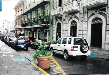
- Traffic in Isleta de San Juan
- La Fortaleza and City Wall of San Juan in Isleta de San Juan
- Fuente Raíces (Roots Fountain) on Paseo de La Princesa in Old San Juan
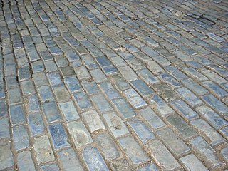
- Blue cobblestone streets of Old San Juan
References
[edit]- ^ "San Juan Puerto Rico-La Isleta". www.puertadetierra.info. Retrieved 2022-12-05.
- ^ "Historia de Puerta de Tierra (San Juan)". www.puertadetierra.info. Retrieved 2022-12-05.
- ^ Morales, Dra Carmen Alicia (2020-09-11). "Historia del Viejo San Juan: 12 de septiembre de 1519 – documento de descripción y plano de la isleta de San Juan". El Adoquín Times (in Spanish). Retrieved 2022-12-05.
- ^ "Los primeros caminos y puentes de la Isla". Directorio Oficial de Puerto Rico. Retrieved 2022-12-05.
- ^ Marley, David (2005). Historic Cities of the Americas. Santa Barbara, CA. pp. 185+. ISBN 1576070271.
{{cite book}}: CS1 maint: location missing publisher (link) - ^ Morales, Dra Carmen Alicia (2020-09-11). "Historia del Viejo San Juan: 12 de septiembre de 1519 – documento de descripción y plano de la isleta de San Juan". El Adoquín Times (in Spanish). Retrieved 2022-12-05.
- ^ (in Spanish) San Juan: Historia Illustrada de su desarrollo urbano, 1508-1898 - Aníbal Sepúlveda Rivera. San Juan 1989. Centro de Investigaciones CARIMAR.
- ^ boricuaonline (2017-01-20). "Río Piedras, Puerto Rico – University City". BoricuaOnline.com. Retrieved 2022-12-05.
- ^ "Caño de San Antonio". wikimapia.org. Retrieved 2022-12-05.
- ^ "National Register of Historic Places Inventory Nomination Form" (PDF). agencias pr gov. Puerto Rico. Retrieved 25 December 2019.
- ^ "Charming Colonial Streets of San Juan to Go Car Free". TreeHugger. Archived from the original on 2019-04-04. Retrieved 2019-04-04.
- ^ "Puente San Antonio (Puente Número 1)". www.puertadetierra.info. Retrieved 2022-12-05.
- ^ "ARRC - Puente Ferroviario San Antonio". Bridgehunter.com. Retrieved 2022-12-05.
- ^ "Puente del ferrocarril en San Juan Puerto Rico". www.puertadetierra.info. Retrieved 2022-12-05.
- ^ "Cierran el acceso vehicular al Viejo San Juan para la SanSe". El Nuevo Dia (in Spanish). 20 January 2019. Archived from the original on 4 April 2019. Retrieved 4 April 2019.
- ^ Ríos, Melissa Cruz (1 December 2019). "Para subir y bajar el Viejo San Juan". El Vocero de Puerto Rico (in Spanish). Archived from the original on 4 April 2019. Retrieved 4 April 2019.

