Картография региона Палестины , также известная как картография Святой Земли и картография Земли Израиля . [1] это создание, редактирование, обработка и печать карт региона Палестины с древних времен до появления современных геодезических методов. В течение нескольких столетий в средние века это был самый заметный предмет во всей картографии . [2] и его описывают как «навязчивый предмет картографического искусства». [3]
В истории картографирования Палестины доминируют две картографические традиции: библейская школа и классическая школа. [4] Самые ранние сохранившиеся карты библейской традиции возникли в результате попыток первых отцов церкви определить и проиллюстрировать основные места, упомянутые в Библии, а также предоставить карты для христианского паломничества . [4] Самые ранние сохранившиеся карты классической традиции взяты из научных и исторических трудов греко-римского мира ; [4] Европейское повторное открытие произведений Птолемея в 1400-х годах положило конец доминированию библейской традиции. [5] Многие греко-римские географы описывали Палестинский регион в своих трудах; однако не сохранилось досовременных оригиналов или копий этих карт — сегодняшние иллюстрации карт, созданных такими географами, как Гекатей , Геродот или Эратосфен, представляют собой современные реконструкции. Самые ранние сохранившиеся классические карты региона представляют собой византийские версии 4-й карты Азии Птолемея . [6] [7] Картографическая история Палестины, таким образом, начинается с Птолемея, работа которого основывалась на работах местного географа Марина из Тира . [5]
Первые списки карт региона были составлены в конце 19 века Титусом Тоблером в его «Географической библиографии Палестины» 1867 года , а затем Рейнхольдом Рёрихтом в его «Географической библиотеке Палестины» 1890 года . [8] [9] В серии статей в журнале Немецкой ассоциации по изучению Палестины между 1891 и 1895 годами Рерихт представил первый подробный анализ карт региона в среднем и позднем средневековье. [8] [10] За ними последовала в 1939-40 годах « Ганса Фишера История картографии Палестины» . [11] В этой статье перечислены карты, которые способствовали развитию картографии региона до появления современных методов съемки, показано, как картографирование и съемка улучшились и помогли посторонним лучше понять географию региона. Воображаемые карты и копии существующих карт исключаются.
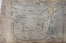
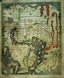
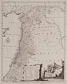
Карта Птолемея, считавшаяся «прототипом» региона, была основана на утерянной работе Марина, родившегося в соседнем Тире . Самая ранняя известная копия, изображенная здесь, — это Codex Vaticanus Urbinas Graecus 82 , предположительно взятая из рукописи «Географии» Птолемея, собранной Максимом Планудесом в Константинополе ок. 1300. [4]
Большие красные буквы в центре означают по -гречески : Παλαιστινης или Palaistinis .
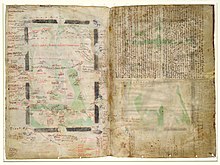
Самая ранняя известная копия датируется 1150 годом. [12] показанная здесь «Турнеская карта Азии». Карта взята из рукописи « De situ et nominibus locorum Hebraeorum» Иеронима , которая, по утверждению Иеронима, является копией «Ономастикона» Евсевия . [12] Иероним также объясняет, что Евсевий составил карту, на которой были показаны подразделения Двенадцати колен ; ни один экземпляр этого подразделения не сохранился. [12]
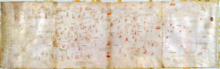
Самая ранняя карта Палестины, сохранившаяся в первоначальном виде. [17] [18] и самая старая известная географическая напольная мозаика в истории искусства. Мозаика была обнаружена в 1884 году, но исследования не проводились до 1896 года. [19] [20] Он активно использовался для локализации и проверки сайтов в византийской Палестине Прима . Это самая ранняя из сохранившихся карт, на которой показаны подразделения Двенадцати колен. [21]
Этикетки по-гречески : , « граница oroi Aigyptou kai Palaistinis Египта и Палестины».
The first medieval Christian world map of relevance to the cartography of Palestine.[22] This copy from 1060 is thought to be the closest to the original out the 14 surviving manuscripts.[22]
Known as the "Anglo-Saxon" world map. The earliest known map of the world (rather than just the region) showing the divisions of the Twelve Tribes. Thought to be based on the map of Orosius, which is no longer extant.[24]
12th century copy of a map of Asia may which accompanied a manuscript of De situ et nominibus locorum Hebraeorum, a 4th-5th century work of Jerome.[27]
Created in c.1250, thought to be by Matthew Paris[28]
The Kishon River has the following text along it: Latin: Iste torrens q[ui] parvus est, dividit Siriam a palestinam, i[d est] terram sactam q[ue] est versus austrum et palestinam que est versus aquilonem, lit. 'This river, which is small, divides Syria from Palestine, that is, the Holy Land, which is to the south, and Palestine, which is to the North.'
Described by Adolf Erik Nordenskiöld as "the first non-Ptolemaic map of a definite country".[32] Published in Liber Secretorum Fidelium Crucis, a work intended to rekindle the spirit of the crusades. Considered the "first 'modern map' of Palestine" and "served as the basis for most maps of 'Modern Palestine'" throughout the following centuries.[33]
Published in the Rudimentum Novitorium it was a version of Ptolemy's map, brought up to date.[35] Together with three updated maps of European countries, Adolf Erik Nordenskiöld described it as the "first germ of modern cartography"[32]
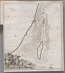
Named "Palestina Moderna et Terra Sancta" (Modern Palestine and the Holy Land)
The caption "Candido lectori s[alus]. Palestinam hanc..." translates as: "Fair reader, greeting! We have drawn this map of Palestine, and the Hebrews' route into it from Egypt through the stony regions of Arabia"[40]
1570 map in Theatrum Orbis Terrarum. [41] Ortelius's depiction of a biblical Palestine in his otherwise contemporary atlas has been criticized; Matari described it as an act "loaded with theological, eschatological, and, ultimately, para-colonial Restorationism".[42]
Captioned "Palaestinae Sive Totius Terrae Promissionis Nova Descriptio" ("Palestine, the whole of the Promised Land, a new description")
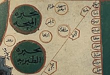
This 1732 copy of the map by Ottoman geographer Kâtip Çelebi (1609–57) is from the first printed atlas in the Ottoman Empire, and represented the first detailed mapping of the Asian provinces of the empire.[45]
Shows the term ارض فلسطين ("Land of Palestine") extending vertically down the length of the Jordan River.
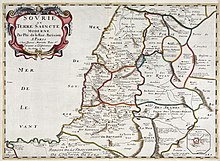
From the 1651 six-map atlas La Terre sainte en six cartes géographiques. It was the first published historical atlas in world cartography, in systematically chronological order. The other five maps covered land of Canaan and the Exodus, the Promised Land, Solomon's kingdom, the land of the Jews at the time of Christ, and the Christian Patriarchate of Jerusalem.[46]
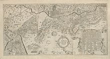
Originally prepared during the French campaign in Egypt and Syria; 47 sheets were prepared, with the Palestine area being covered by sheets 43-47. The first triangulation-based map of Palestine, it was used as the basis for many most maps of the region until the PEF Survey in the 1870s.[49][50] It is considered flawed, primarily since it included a significant number of incorrect or imagined details, which had been “added to the map ad libitum where the French had not been able to survey.”[50]
The first modern printed atlas in the Ottoman Empire, part of the Nizam-I Cedid reforms of Sultan Selim III, showing Ottoman Syria in the 1803.[45] Considered to be based on the d'Anville 1794 map (published in William Faden's General Atlas), it contained important adaptations to represent Ottoman geographic representations of the provinces.[45]
Shows the term "ارض فلاستان" ("Land of Palestine") in large script on the bottom left.
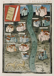
The title "A Sketch of the Countries between Jerusalem and Aleppo" is likely a reference to Henry Maundrell's Journey from Aleppo to Jerusalem published in 1703; the map's description of Jacob's Well is a direct quote from Maundrell. The map also quotes Ulrich Jasper Seetzen, whose Brief Account of the Countries Adjoining the Lake of Tiberias, the Jordan and the Dead Sea was published in 1809.[51] The map is a combination of a modern map and a biblical map (showing the Twelve Tribes)[51]
The first British army survey, carried out during the Oriental Crisis of 1840. It represented the second modern, triangulation-based, attempt at surveying Palestine.[50] It was not published at the time; although a private printing for the British Foreign Office was produced in 1846, and it was used in the creation of Van de Velde's map.[50]
Published in 1841 to accompany the first edition of Biblical Researches in Palestine by Edward Robinson, known as the "Father of Biblical Geography", and again in 1856 to accompany the second edition.[52]
Shows the Ottoman administrative districts in detail, made for the Society for the Diffusion of Useful Knowledge. Hughes had been producing popular maps of Palestine for almost a decade, notably in his 1840 Illuminated Atlas of Scripture geography.[53]
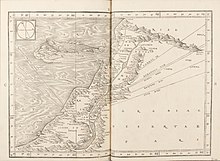
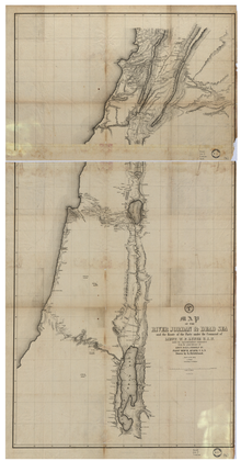
Prepared on behalf of the United States Hydrographic Office. Published in Narrative of the United States' Expedition to the River Jordan and the Dead Sea.
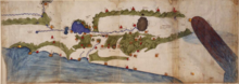
The Dead Sea and River Jordan
1850
Zimmermann map
Carl Zimmermann
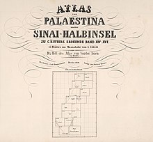
The Atlas von Palaestina und der Sinai Halbinsel, in 15 sectional sheets. Part of a wider Atlas of Asia, published as a supplement to Carl Ritter's Erdkunde
Published in 1858. One of the most accurate maps published prior to the PEF Survey.[54]
The Holy Land
1870
Leves en Galilee
Jean-Joseph Mieulet and Isidore Derrien
A follow-up to a map of Lebanon. It was intended to be the first part of a complete coverage of Palestine, but the expedition was recalled to France at the outbreak of the Franco-Prussian war. It was published in 1873.[55]
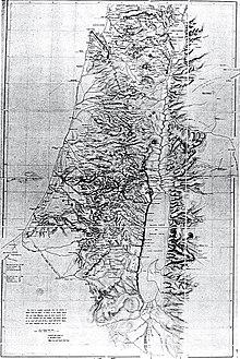
Carried out by the Palestine Exploration Fund, with support from the War Office.[56] Represented the peak of the cartographic work in Palestine in the nineteenth century.[57]
26 sheets of "Western Palestine" and 1 sheet of "Eastern Palestine".
^Laor 1986, p. XI quote: "Cartography in the Middle Ages was generally of poor quality, with the exception of the cartography of the Holy Land, which reached a peak both in quality and quantity. For several centuries, the Holy Land was the most important and prominent subject of mapmaking.
^Wood 2010, p. 232: "In fact, the mapping of Palestine is a paradigm of the history of mapmaking; but since it’s also the object of counter-mapping and counter-counter-mapping, and an obsessive subject of map art, it makes a uniquely trenchant example around which to review the arguments of this book."
^ Jump up to: abNebenzahl 1986, p. 8: "Cartography as we know it today begins with this spectacular map of the world at the time of Claudius Ptolemy. It sets the stage for the history of mapping the Holy Land... his work was to become the model for scientific cartography during the great revivals of mapmaking: the tenth-century Golden Age of Islam and the European Renaissance. The rediscovery of Ptolemy in the fifteenth century was particularly important for maps of the Holy Land; it ended the almost complete domination of mapmaking by Church dogma throughout the Middle Ages... Around AD 150 he produced his Geographia, the earliest known atlas of the world.".
^Wilson, Nigel Guy (2006). "Cartography". Encyclopedia of Ancient Greece. Psychology Press. p. 145. ISBN978-0-415-97334-2. As geographical knowledge improved, various writers recorded what they believed to be the spatial relationships of territories and peoples to each other, and it is from this information that many modern historical atlases present items such as the world according to Hecataeus or Herodotus or Eratosthenes: actual ancient versions of these maps do not survive (indeed, modern versions seem to originate in the 1883 volumes of Bunbury), although there do exist Byzantine versions of Ptolemy's maps.
^Leo Bagrow, “The Origin of Ptolemy's Geographia.” Geografiska Annaler, vol. 27, 1945, pp. 318–387. JSTOR, www.jstor.org/stable/520071; p.331, “Hecataeus of Milet… Herodotus… Dicaearchus of Messina… Crates of Mallos… Hipparchus… Posidonius of Apamea… Marinus of Thyre… All these maps before Ptolemy have, naturally, not come down to us.”
^Nebenzahl 1986, p. 2: "The Madaba mosaic, the earliest surviving original map of the area and the first to show the Twelve Tribes of Israel"
^North 1979, p. 85: "Certainly it is the oldest map of Palestine now existing in the form in which it was first produced"
^Piccirillo, Michele (September 21, 1995). "A Centenary to be celebrated". Jordan Times. Franciscan Archaeology Institute. Retrieved 18 January 2019. It was only Abuna Kleofas Kikilides who realised the true significance, for the history of the region, that the map had while visiting Madaba in December 1896. A Franciscan friar of ltalian-Croatian origin born in Constantinople, Fr. Girolamo Golubovich, helped Abuna Kleofas to print a booklet in Greek about the map at the Franciscan printing press of Jerusalem. Immediately afterwards, the Revue Biblique published a long and detailed historic-geographic study of the map by the Dominican fathers M.J. Lagrange and H. Vincent after visiting the site themselves. At the same time. Father J. Germer-Durand of the Assumptionist Fathers published a photographic album with his own pictures of the map. In Paris, C. Clermont-Gannau, a well known oriental scholar, announced the discovery at the Académie des Sciences et belles Lettres.
^Nebenzahl 1986, p. 18a"The Madaba Mosaic is the earliest surviving map to show the tribal divisions, and its text is almost identical with the surviving Greek manuscript of Eusebius's Onomastikon"
^ Jump up to: abBaumgärtner, Ingrid. "Burchard of Mount Sion and the Holy Land," Peregrinations: Journal of Medieval Art and Architecture 4, 1 (2013): 5-41. : "Burchard’s description, although little studied even today, is considered a key document that influenced the perception of Palestine in both text and image, in travel accounts and maps until far into the sixteenth century."
^Goffart, W. (2011). Historical Atlases: The First Three Hundred Years, 1570-1870. University of Chicago Press. p. 108-110. ISBN978-0-226-30072-6. La Ruë was a Holy Land specialist associated with the mapmaking enterprise of Nicolas Sanson, patriarch of French cartography. Hardly anything is known of La Ruë. His small atlas, La Terre sainte en six cartes géographiques (Paris, 1651), is the first collection of maps laid out "from the origins to the present," in a systematically chronological order. This sequence, now commonplace, was so far from customary in La Ruë's time that no one imitated it for about fifty years.
^ Dov Gavish (1994) French Cartography of the Holy Land in the Nineteenth Century, Palestine Exploration Quarterly, 126:1, 24-31, DOI: 10.1179/peq.1994.126.1.24
^Masalha 2019, p. 256a: "The systematic mapping, surveying and place‐naming projects ... reached their peak with the British Ordnance Survey of Western Palestine between 1871 and 1877."
Fischer, Hans[in German] (1939). "Geschichte Der Kartographie Von Palästina" [History of the Cartography of Palestine (part 1)]. Zeitschrift des Deutschen Palästina-Vereins. 62 (4): 169–189. JSTOR27930237.
—— (1940). "Geschichte Der Kartographie Von Palästina (Fortsetzung Und Schluß)" [History of the Cartography of Palestine (continuation and conclusion)]. Zeitschrift des Deutschen Palästina-Vereins. 63 (1): 1–111. JSTOR27930252.
Кармон, Иегуда [на иврите] (1960). «Анализ карты Палестины Жакотена». Израильский журнал исследований . 10 (3): 155–173. JSTOR 27924824 .
Калнер, Дэвид [на иврите] (1941). «Развитие топографического картографирования Израиля». Бюллетень Еврейского общества исследования Палестины 9 (1): 33–38. JSTOR 23724373 .
Arc.Ask3.Ru Номер скриншота №: ae0ccd7d9956f0f6fd9ff0fe0ead0028__1706392080 URL1:https://arc.ask3.ru/arc/aa/ae/28/ae0ccd7d9956f0f6fd9ff0fe0ead0028.html Заголовок, (Title) документа по адресу, URL1: Cartography of Palestine - Wikipedia
Данный printscreen веб страницы (снимок веб страницы, скриншот веб страницы), визуально-программная копия документа расположенного по адресу URL1 и сохраненная в файл, имеет: квалифицированную, усовершенствованную (подтверждены: метки времени, валидность сертификата), открепленную ЭЦП (приложена к данному файлу), что может быть использовано для подтверждения содержания и факта существования документа в этот момент времени. Права на данный скриншот принадлежат администрации Ask3.ru, использование в качестве доказательства только с письменного разрешения правообладателя скриншота. Администрация Ask3.ru не несет ответственности за информацию размещенную на данном скриншоте. Права на прочие зарегистрированные элементы любого права, изображенные на снимках принадлежат их владельцам. Качество перевода предоставляется как есть. Любые претензии, иски не могут быть предъявлены. Если вы не согласны с любым пунктом перечисленным выше, вы не можете использовать данный сайт и информация размещенную на нем (сайте/странице), немедленно покиньте данный сайт. В случае нарушения любого пункта перечисленного выше, штраф 55! (Пятьдесят пять факториал, Денежную единицу (имеющую самостоятельную стоимость) можете выбрать самостоятельно, выплаичвается товарами в течение 7 дней с момента нарушения.)


 СМИ, связанные со старыми картами Палестины, на Викискладе?