Бака, неудача

Бар
нежно Бурка | |
|---|---|
![Макам (храм) Неби Берк, в 1898 году [1]](http://upload.wikimedia.org/wikipedia/commons/thumb/9/91/Neby_Berak_1898_%28Gautier%29.jpg/250px-Neby_Berak_1898_%28Gautier%29.jpg) Макам (храм) Неби Берк, в 1898 году [ 1 ] | |
| Этимология: песчаная земля, покрытая кремнем [ 2 ] | |
 A series of historical maps of the area around Barqa, Gaza (click the buttons) | |
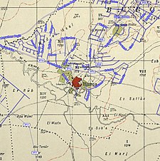
 Barqa Location within Mandatory Palestine | |
| Coordinates: 31°46′35″N 34°42′5″E / 31.77639°N 34.70139°E | |
| Palestine grid | 121/131 |
| Geopolitical entity | Mandatory Palestine |
| Subdistrict | Gaza |
| Date of depopulation | May 13, 1948[5] |
| Area | |
| • Total | 5,206 dunams (5.206 km2 or 2.010 sq mi) |
| Population (1945) | |
| • Total | 890[3][4] |
| Cause(s) of depopulation | Military assault by Yishuv forces |
| Current Localities | Gan Yavne |


Барка ( арабский : برقة ) была палестинской арабской деревней, расположенной в 37 км к северу от Газы недалеко от современного израильского города Ашдод . назвали его Баркой Греки во и барека римлянами филистимским древним время их правления над городом. В 1945 году в деревне было 890 человек, а общая площадь земли - 5206 Dunums .
Он был занят и депопулирован 13 мая 1948 года во время операции Барак , наступления Ишув в южной Палестине непосредственно перед началом арабо-израильской войны 1948 года . Руины деревни были позже включены в израильский город Ган Явн .
История
[ редактировать ]Вполне вероятно, что Барка была построена на месте греческого города Барка, который римляне называли Baraca. Сельские жители были мусульманами, а вокруг сельской мечети было несколько гробниц, которые они называли как гробницы Шейха Мухаммеда, Шейха Заррука и пророка (аль-Наби). [ 6 ]
Захоронения с четырьмя Аркосолией была обнаружена в Барке. В нем содержались три гончарные лампы, датированные поздней римской или византийской эпохой, и два византийских стеклянных сосуда, датированных пятым веком н.э. [ 7 ] Деревня была главным центром в византийскую эпоху. В 511 году была построена богато украшенная церковь базилики с мозаичным полом. Он использовался до седьмого века. [ 8 ]
Османская эра
[ редактировать ], как и остальная часть Палестины, была включена в Османскую империю в 1517 году, а в 1596 года деревня была расположена в Нахии Газза переписи в Ливе Газза Барка . В нем было 12 домохозяйств, все мусульманин . Они заплатили фиксированную налоговую ставку на 25% на сельскохозяйственную продукцию, включая пшеницу, ячмень, летние культуры, фруктовые деревья и кунжут; Налоги составили 2100 Акче . [ 9 ]
В 1838 году Робинсон отметил Бурку как мусульманскую деревню, расположенную в районе Газа. [ 10 ]
В 1863 году Виктор Герин посетил и отметил, лежа рядом с колодцем , несколько стволов серовато -мрамора. Куббе , и окружен был здесь, посвящен Neby Barak гробницами. [ 11 ] Список Османской деревни примерно в 1870 году показал, что Бурки насчитывает 202 года, в общей сложности 80 домов, хотя число населения включало только мужчин. население [ 12 ] [ 13 ]
В 1882 году ПЭФ обзор западной палестины описала Барку как «обычную» деревню с гробницей Неби Берк . [ 14 ]
Британский мандат Палестины
[ редактировать ]

In the 1922 census of Palestine conducted by the British Mandate authorities, Burqa had a population of 448 inhabitants, all Muslims,[15] which had increased in the 1931 census to 600, 593 Muslim, 6 Jews and 1 Christian, in a total of in 123 houses.[16]
In the 1945 statistics the population of Barqa consisted of 890, all Muslims,[3] and the land area was 5,206 dunams, according to an official land and population survey.[4] Of this, 667 dunams were designated for citrus and bananas, 47 for plantations and irrigable land, 4,031 for cereals,[17] while 26 dunams were built-up areas.[18]
1948 and aftermath
[edit]Barqa became depopulated on May 13, 1948, after a military assault by the Yishuv's Giv'ati forces.[5][19][20] The area was subsequently incorporated into the State of Israel. In 1992, the village remaining structures on the village land were described:
"Two houses remain standing on the site. One serves as a warehouse; it is made of concrete and has a covered portico on two sides. The other, a stone house with rectangular doors and windows and a flat roof, stands deserted in the midst of wild vegetation. The site is overgrown with weeds interspersed with cactuses and eucalyptus and palm trees. Israelis cultivate the land around the site."[21]
References
[edit]- ^ Gautier, 1898, p. 95
- ^ Palmer, 1881, p. 267
- ^ Jump up to: a b Department of Statistics, 1945, p. 31
- ^ Jump up to: a b c Government of Palestine, Department of Statistics. Village Statistics, April, 1945. Quoted in Hadawi, 1970, p. 45
- ^ Jump up to: a b Morris, 2004, p. xix, village #280.Also gives cause of depopulation
- ^ Khalidi, 1992, pp. 82-83
- ^ Volynsky, 2010, Barqa (North)
- ^ Sion, Rapuano, Habas and Di Segni, 2010, Barqa
- ^ Hütteroth and Abdulfattah, 1977, p. 147
- ^ Robinson and Smith, vol 3, 2nd appendix, p. 118
- ^ Guérin, 1869, pp. 68-70; as given by Conder and Kitchener, 1882, SWP II, p. 420
- ^ Socin, 1879, p. 149 Also noted in the Gaza district
- ^ Hartmann, 1883, p. 134 also noted 80 houses
- ^ Conder and Kitchener, 1882, SWP II, p. 409. Cited in Khalidi, 1992, p. 84
- ^ Barron, 1923, Table V, Sub-district of Gaza, p. 9
- ^ Mills, 1932, p. 2
- ^ Government of Palestine, Department of Statistics. Village Statistics, April, 1945. Quoted in Hadawi, 1970, p. 86
- ^ Government of Palestine, Department of Statistics. Village Statistics, April, 1945. Quoted in Hadawi, 1970, p. 136
- ^ Morris, 2004, p. 179, note #112, p. 271
- ^ Morris, 2004, p. 256 note #759, p 305
- ^ Khalidi, 1992, p. 83
Bibliography
[edit]- Barron, J. B., ed. (1923). Palestine: Report and General Abstracts of the Census of 1922. Government of Palestine.
- Ben-Ari, Chen (2012-02-14). "Barqa, Gan Yavne" (124). Hadashot Arkheologiyot – Excavations and Surveys in Israel.
{{cite journal}}: Cite journal requires|journal=(help) - Conder, C.R.; Kitchener, H. H. (1882). The Survey of Western Palestine: Memoirs of the Topography, Orography, Hydrography, and Archaeology. Vol. 2. London: Committee of the Palestine Exploration Fund.
- Dauphin, C. (1998). La Palestine byzantine, Peuplement et Populations. BAR International Series 726 (in French). Vol. III : Catalogue. Oxford: Archeopress. ISBN 0-860549-05-4. p. 862
- Department of Statistics (1945). Village Statistics, April, 1945. Government of Palestine.
- Gautier, L. (1898). Souvenirs de Terre-Sainte (in French) (2 ed.). Lausanne: Georges Bridel.
- Gonen, Ilana (2014-06-23). "Barqa (South)" (126). Hadashot Arkheologiyot – Excavations and Surveys in Israel.
{{cite journal}}: Cite journal requires|journal=(help) - Guérin, V. (1869). Description Géographique Historique et Archéologique de la Palestine (in French). Vol. 1: Judee, pt. 2. Paris: L'Imprimerie Nationale.
- Hadawi, S. (1970). Village Statistics of 1945: A Classification of Land and Area ownership in Palestine. Palestine Liberation Organization Research Centre.
- Hartmann, M. (1883). "Die Ortschaftenliste des Liwa Jerusalem in dem türkischen Staatskalender für Syrien auf das Jahr 1288 der Flucht (1871)". Zeitschrift des Deutschen Palästina-Vereins. 6: 102–149.
- Hütteroth, Wolf-Dieter; Abdulfattah, Kamal (1977). Historical Geography of Palestine, Transjordan and Southern Syria in the Late 16th Century. Erlanger Geographische Arbeiten, Sonderband 5. Erlangen, Germany: Vorstand der Fränkischen Geographischen Gesellschaft. ISBN 3-920405-41-2.
- Khalidi, W. (1992). All That Remains: The Palestinian Villages Occupied and Depopulated by Israel in 1948. Washington D.C.: Institute for Palestine Studies. ISBN 0-88728-224-5.
- Mills, E., ed. (1932). Census of Palestine 1931. Population of Villages, Towns and Administrative Areas. Jerusalem: Government of Palestine.
- Morris, B. (2004). The Birth of the Palestinian Refugee Problem Revisited. Cambridge University Press. ISBN 978-0-521-00967-6.
- Palmer, E. H. (1881). The Survey of Western Palestine: Arabic and English Name Lists Collected During the Survey by Lieutenants Conder and Kitchener, R. E. Transliterated and Explained by E.H. Palmer. Committee of the Palestine Exploration Fund.
- Sion, Ofer; Rapuano, Yehudah; Di Segni, Leah (2010-09-05). "Barqa" (122). Hadashot Arkheologiyot – Excavations and Surveys in Israel.
{{cite journal}}: Cite journal requires|journal=(help) - Robinson, E.; Smith, E. (1841). Biblical Researches in Palestine, Mount Sinai and Arabia Petraea: A Journal of Travels in the year 1838. Vol. 3. Boston: Crocker & Brewster.
- Socin, A. (1879). "Alphabetisches Verzeichniss von Ortschaften des Paschalik Jerusalem". Zeitschrift des Deutschen Palästina-Vereins. 2: 135–163.
- Torge, Hagit (2006-07-02). "Barqa (North)" (118). Hadashot Arkheologiyot – Excavations and Surveys in Israel.
{{cite journal}}: Cite journal requires|journal=(help) - Torge, Hagit (2006-08-03). "Barqa (East)" (118). Hadashot Arkheologiyot – Excavations and Surveys in Israel.
{{cite journal}}: Cite journal requires|journal=(help) - Volynsky, Felix (2010-01-03). "Barqa (North)" (122). Hadashot Arkheologiyot – Excavations and Surveys in Israel.
{{cite journal}}: Cite journal requires|journal=(help)
External links
[edit]- Barqa, at Palestine Remembered
- Barqa, Zochrot
- Survey of Western Palestine, Map 16: IAA, Wikimedia commons
- Tomb of the Neby Burk (Barq)
- Barqa from the Khalil Sakakini Cultural Center
