Гурдаспурский район

Эта статья , возможно, содержит оригинальные исследования . ( Июнь 2019 г. ) |
Гурдаспурский район | |
|---|---|
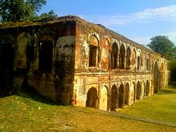 Форт Суджанпур | |
 Location in Punjab | |
| Coordinates: 31°55′N 75°15′E / 31.917°N 75.250°E | |
| Country | |
| State | Punjab |
| Headquarters | Gurdaspur |
| Area | |
| • Total | 2,610 km2 (1,010 sq mi) |
| Population (2011)[‡] | |
| • Total | 2,298,323 |
| • Density | 880/km2 (2,300/sq mi) |
| Languages | |
| • Official | Punjabi |
| Time zone | UTC+5:30 (IST) |
| Vehicle Code | PB 06,PB 18,PB 58,PB 85, PB 99 |
| Literacy | 79.95% |
| Website | gurdaspur |
Гурдаспурский район - это район в регионе Маджха штата Пенджаб , Индия. Гурдаспур - это районная штаб -квартира. На международном уровне граничит с районом Нароваля Пакистанского Пенджаба и округах Амритсар , Патанкот , Капуртала и Хошиарпур . Два основных рек Беас и Рави проходят через район. Моголов Акбар Говорят , что император был выдвинут на пресс в саду недалеко от Каланавра , исторически важного города в округе. [ 1 ] Район находится в предгорьях Гималаев .
По состоянию на 2011 год это третий по численности густонаселенного района Пенджаба (из 22 ), после Лудхианы и Амритсара . [ 2 ] Батала , с 31% населения округа, является его крупнейшим городом.
History
[edit]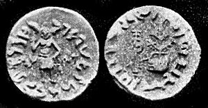
Obv: Standing figure, probably of Vishvamitra, Kharoshthi legend, around: Mahadevasa Dharaghoshasa/Odumbarisa "Great Lord King Dharaghosha/Prince of Audumabara", across: Viçvamitra "Vishvamitra".
Rev: Trident battle-axe, tree with railing, Brahmi legend identical in content to the obverse.[3]
Medieval period
[edit]This area was used as a base by Banda Singh Bahadur to raid the area up to Lahore. The Mughal emperor Bahadur Shah conducted an expedition against him in 1711, but with only temporary effect. Banda Singh Bahadur fought his last battle against Mughals at Gurdas Nangal and was captured.[4][5]
On 17 May 1746, the Chhota Ghallughara (smaller Sikh genocide) took place. Approximately 10,000 to 15,000 Sikhs were killed in battle on a single day in Kahnuwan, near Gurdaspur. Under the Lahore governorship of Yahiya Khan, Lakhpat Rai (revenue minister) and Shah Navaz Khan were directed to avenge the killing of Lakhpat Rai's brother, Jaspat Rai. An official decree to exterminate Sikhs was issued.[citation needed]
In about 1633 CE, during the rule of Shah Jahan, the Badshahi canal was constructed for carrying waters to the Shalimar Gardens at Lahore. Maharaja Ranjit Singh constructed Hansali canal to carry waters to the tank of the Golden Temple.[6]
British Raj
[edit]
The district of Gurdaspur came into being in April 1846 after the annexation of Punjab by the British.[7] During British Rule the district of Gurdaspur was a subdivision of Lahore Division, the district itself was administratively subdivided into four tehsils: Gurdaspur, Batala, Shakargarh and Pathankot. During the India's first war of independence, on 12 July 1857, battle of Trimmu Ghat was fought between the forces of British and Indian rebel sepoys on the left bank of Ravi.[8]Trimmu Ghat was about 9 miles west of Gurdaspur city in the district. Most of the Indian rebel sepoys were killed in the battle.[9]
According to the 1881 census the population of the district was 823,695 this had risen by over 100,000 to 943,922 in the 1891 census. However, the 1901 census recorded a fall in population – 940,334, this was largely due to emigration – some 44,000 settlers settling in Chenab colony. According to the 1901 census there were 463,371 Muslims (49%), 380,636 Hindus (over 40%) and 91,756 (10%) Sikhs. Mirza Ghulam Ahmad who founded the Ahmadiyya movement had followers here.[10]
During the partition of India in 1947 the future of Gurdaspur was highly contested. According to the 1941 census, the population of this district had a narrow 51.14% Muslim majority. Radcliffe Award of the boundary gave only the Shakargarh tehsil of the district to Pakistan, and the rest to India. The Muslim population of the eastern tehsils migrated to Pakistan as refugees, and the Hindus and Sikhs of Shakargarh migrated to Gurdaspur after crossing the Ravi Bridge. They settled and spread in the Gurdaspur district. According to the 1951 census, there were around 2,97,581 displaced persons who had settled in the district, who formed about 34.96% of the district population.[11] Of the total displaced persons 1,59,716 were males and 1,37,865 females. The origin of most of them were pakistani districts of Sialkot (1,93,182), Shakargarh (43,203), Lyallpur (17,783) and Shekhupura (8,826).[12]
Modern India
[edit]New tehsil of Dera Baba Nanak was created in 1995 and Dhar Kalan in 1996.[13] On 27 July 2011 a part of district was carved out to form a new Pathankot district, which was earlier part of Gurdaspur. The Pathankot district comprises two sub-divisions of Pathankot and Dharkalan along with two sub-tehsils namely Narot Jaimal Singh and Bamial.
On 27 July 2015, there was a terror attack in Dinanagar, which is situated in the northern part of the district. During this, three heavily armed terrorists wearing army uniforms attacked a bus and police station. Before being killed in 12 hour long operation, the terrorists killed 7 people, of which 2 were civilians, 2 policemen, 2 home guards and one Superintendent of Police (SP). About 5 kilometres from Dinanagar, five live bombs were found on a small bridge near Parmanand railway station on the Amritsar-Pathankot railway track, which were later disposed. The terrorists were said to have come Pakistan. It was the first major terror attack in Punjab since 1995.[14]
Geography
[edit]Location
[edit]The Gurdaspur district is in the north of Punjab state. It falls in the Jalandhar division and is sandwiched between rivers Ravi and Beas. The district lies between north-latitude 31°36' and 32°34' and east longitude 74°56' and 75°24' and shares common boundaries with Pathankot district in the north, Beas River in the north-east, Hoshiarpur district in the south-east, Kapurthala district in the south, Amritsar district in the south-west and Pakistan in the north-west. It is a border district of Punjab and lies along India-Pakistan border.
Government and politics
[edit]Politics
[edit]| No. | Constituency | Name of MLA | Party | Bench | |
|---|---|---|---|---|---|
| 4 | Gurdaspur | Barindermeet Singh Pahra | Indian National Congress | Opposition | |
| 5 | Dina Nagar (SC) | Aruna Chaudhary | Indian National Congress | Opposition | |
| 6 | Qadian | Partap Singh Bajwa | Indian National Congress | Opposition | |
| 7 | Batala | Amansher Singh (Shery Kalsi) | Aam Aadmi Party | Government | |
| 8 | Sri Hargobindpur (SC) | Amarpal Singh | Aam Aadmi Party | Government | |
| 9 | Fatehgarh Churian | Tripat Rajinder Singh Bajwa | Indian National Congress | Opposition | |
| 10 | Dera Baba Nanak | Sukhjinder Singh Randhawa | Indian National Congress | Opposition | |
Tehsil
[edit]
|
Sub Tehsils (Total : 7)
[edit]| Sr. No. | Sub Tehsil Name |
|---|---|
| 1. | Kahnuwan |
| 2. | Sri Hargobindpur |
| 3. | Qadian |
| 4. | Fatehgarh Churian |
| 5. | Dhariwal |
| 6. | Naushera Majha Singh |
| 7. | Dorangla |
C.D. Blocks (Total : 11)
[edit]| Sr. No. | Block Name |
|---|---|
| 1. | Gurdaspur |
| 2. | Kalanaur |
| 3. | Dhariwal |
| 4. | Kahnuwan |
| 5. | Dinanagar |
| 6. | Batala |
| 7. | Fatehgarh Churian |
| 8. | Dera Baba Nanak |
| 9. | Sri Hargobindpur |
| 10. | Qadian |
| 11. | Dorangla |
Municipal Corporation (Nagar Nigam)
[edit]| Sr. No. | Corporation Name |
|---|---|
| 1. | Batala |
Municipal Councils
[edit]| Sr. No. | Municipal Name |
|---|---|
| 1. | Gurdaspur |
| 2. | Dhariwal |
| 3. | Dinanagar |
| 4. | Sri Hargobindpur |
| 5. | Dera Baba Nanak |
| 6. | Fatehgarh Churian |
| 7. | Qadian |
Villages
[edit]- Bangowani
- Barnala
- Dabanwala
- Khojala
- Talwandi Jheuran
- Vero Nangal
- Zahadpur
- Zahidpur
- Mallianwal
- Khanowal
- Daaduwal
- Rorr khehra
- Naagan de dere
- Bhagowal
- Sarhwali
- Dalam
Demographics
[edit]Population
[edit]| Year | Pop. | ±% p.a. |
|---|---|---|
| 1901 | 702,372 | — |
| 1911 | 622,008 | −1.21% |
| 1921 | 634,394 | +0.20% |
| 1931 | 718,523 | +1.25% |
| 1941 | 854,968 | +1.75% |
| 1951 | 851,140 | −0.04% |
| 1961 | 980,868 | +1.43% |
| 1971 | 1,229,464 | +2.28% |
| 1981 | 1,513,435 | +2.10% |
| 1991 | 1,756,732 | +1.50% |
| 2001 | 2,103,455 | +1.82% |
| 2011 | 2,298,323 | +0.89% |
| source:[15] | ||
According to the 2011 census Gurdaspur district has a population of 2,298,323,[2] roughly equal to the nation of Latvia[16] or the US state of New Mexico.[17] This gives it a ranking of 196th in India (out of a total of 640).[2] The district has a population density of 649 inhabitants per square kilometre (1,680/sq mi).[2] Its population growth rate over the decade 2001–2011 was 9.3%.[2] Gurdaspur has a sex ratio of 895 females for every 1000 males,[2] and a literacy rate of 79.95%.[2]
After the separation of the Pathankot tehsil into a separate district in 2011, the residual district has a population of 1,621,725 of which 1,260,572 were rural and 361,153 were urban. Scheduled Castes have a population of 373,544 (23.03%) of the population. Punjabi is the predominant language, spoken by 98.27% of the population.[18]
Gender
[edit]The table below shows the sex ratio of Gurdaspur through the years, according to various census years.[19] Note:- The figure for 2011 does not include the data of the areas that currently form Pathankot district, which were separated from Gurdaspur on that year, to form a new district.
| Year
(Census) |
Sex Ratio |
|---|---|
| 2011 | 907 |
| 2001 | 890 |
| 1991 | 903 |
| 1981 | 907 |
| 1971 | 890 |
| 1961 | 869 |
| 1951 | 846 |
| 1941 | 843 |
| 1931 | 809 |
| 1921 | 794 |
| 1911 | 774 |
| 1901 | 853 |
The table below shows the child sex ratio of children below the age of 6 years in the rural and urban areas of Gurdaspur district. Note:- The data till year 2001 also includes the data from the areas currently in the Pathankot district.
| Year | Urban | Rural |
|---|---|---|
| 2011 | 828 | 818 |
| 2001 | 762 | 797 |
According to the National Family Health Survey - 4 (2015-16), 88.2% of the total women between the ages of 15 and 49 years in Gurdaspur district were literate, this rate was 86.7% for rural areas of the district. For men in the same age group, 90.4% were literate and this rate was 90.7% for rural areas. According to the same survey, 62.7% of the women of the same age group had 10 or more years of schooling and this rate was 57.6% for rural areas.[22]
Rural and Urban
[edit]The table below shows the percentage of rural population through the decades.[23] Note:- The separation of the areas in the current Pathankot district in 2011, may have significantly changed the numbers and figures for that year.
| Year | Percentage |
|---|---|
| 2011 | 77.73% |
| 2001 | 74.56% |
| 1991 | 78.02% |
| 1981 | 78.31% |
| 1971 | 79.7% |
The table below gives the absolute number of rural and urban population through the years.[25][26] Note:- The separation of the areas in the current Pathankot district in 2011, may have significantly changed the numbers and figures for that year.
| Year | Urban | Rural |
|---|---|---|
| 2011 | 3,61,153 | 12,60,572 |
| 2001 | 5,35,223 | 15,68,788 |
| 1991 | 3,86,412 | 13,71,796 |
| 1981 | 3,28,268 | 11,85,167 |
| 1971 | 2,49,084 | 9,80,165 |
Religion
[edit]Religion in Gurdaspur District, 2011
Sikhism is the largest religion in the residual district with 950,016 (58.58%), while Hinduism is the second-largest with 476,095 (29.36%). Christians are the third-largest community with 169,295 (10.44%), the highest share of Christians in the state, and Muslims 13,350 (0.82%).[29] Before Partition, undivided Gurdaspur district had a slight Muslim majority with a large Hindu minority and smaller Sikh and Christian populations. The area which now forms the current district had a Muslim majority and a large Sikh minority, with smaller Hindu and Christian populations.
| Religious group |
1941[30]: 61–62 | 2011[31] | ||
|---|---|---|---|---|
| Pop. | % | Pop. | % | |
| Islam |
380,775 | 53.72% | 13,350 | 0.82% |
| Sikhism |
193,108 | 27.24% | 950,016 | 58.58% |
| Hinduism |
90,412 | 12.75% | 476,095 | 29.36% |
| Christianity |
43,176 | 6.09% | 169,295 | 10.44% |
| Others [c] | 1,401 | 0.20% | 12,969 | 0.80% |
| Total Population | 708,872 | 100% | 1,621,725 | 100% |
The table below shows the population of different religions in absolute numbers in the urban and rural areas of Gurdaspur district.[32] Note:- The separation of the areas in the current Pathankot district in 2011, may have significantly changed the numbers and figures for that year.
| Religion | Urban (2011) | Rural (2011) | Urban (2001) | Rural (2001) | Urban (1991) | Rural (1991) |
|---|---|---|---|---|---|---|
| Hindu | 4,78,989 | 5,95,343 | 3,79,724 | 6,16,522 | 2,51,831 | 4,76,531 |
| Sikh | 1,40,536 | 8,62,338 | 1,28,697 | 8,06,266 | 66,020 | 6,09,380 |
| Christian | 26,151 | 1,50,436 | 21,668 | 1,27,315 | 8,713 | 90,924 |
| Muslim | 8,292 | 5,351 | 4,329 | 807 | 1,540 | 164 |
| Other religions | 5,351 | 11,512 | 807 | 2,246 | 164 | 510 |
| Religious group |
1901[34] | 1911[35][36] | 1921[37] | 1931[38] | 1941[39] | |||||
|---|---|---|---|---|---|---|---|---|---|---|
| Pop. | % | Pop. | % | Pop. | % | Pop. | % | Pop. | % | |
| Islam |
463,371 | 49.28% | 408,216 | 48.78% | 422,877 | 49.62% | 493,216 | 50.8% | 589,923 | 51.14% |
| Hinduism |
380,636 | 40.48% | 284,017 | 33.94% | 258,823 | 30.37% | 255,949 | 26.36% | 290,774 | 25.21% |
| Sikhism |
91,756 | 9.76% | 121,078 | 14.47% | 137,625 | 16.15% | 178,471 | 18.38% | 221,261 | 19.18% |
| Christianity |
4,471 | 0.48% | 23,365 | 2.79% | 32,832 | 3.85% | 43,243 | 4.45% | 51,522 | 4.47% |
| Jainism |
72 | 0.01% | 73 | 0.01% | 20 | 0% | 15 | 0% | 25 | 0% |
| Zoroastrianism |
28 | 0% | 22 | 0% | 12 | 0% | 2 | 0% | 6 | 0% |
| Buddhism |
0 | 0% | 0 | 0% | 3 | 0% | 2 | 0% | 0 | 0% |
| Judaism |
0 | 0% | 0 | 0% | 0 | 0% | 0 | 0% | 0 | 0% |
| Others | 0 | 0% | 0 | 0% | 0 | 0% | 0 | 0% | 0 | 0% |
| Total population | 940,334 | 100% | 836,771 | 100% | 852,192 | 100% | 970,898 | 100% | 1,153,511 | 100% |
| Note: British Punjab province era district borders are not an exact match in the present-day due to various bifurcations to district borders — which since created new districts — throughout the historic Punjab Province region during the post-independence era that have taken into account population increases. | ||||||||||
| Tehsil | Hinduism |
Islam |
Sikhism |
Christianity |
Jainism |
Others[d] | Total | |||||||
|---|---|---|---|---|---|---|---|---|---|---|---|---|---|---|
| Pop. | % | Pop. | % | Pop. | % | Pop. | % | Pop. | % | Pop. | % | Pop. | % | |
| Gurdaspur Tehsil | 57,281 | 17.42% | 171,498 | 52.16% | 76,695 | 23.32% | 22,506 | 6.84% | 22 | 0.01% | 817 | 0.25% | 328,819 | 100% |
| Batala Tehsil | 33,610 | 8.84% | 209,277 | 55.07% | 116,413 | 30.63% | 20,670 | 5.44% | 0 | 0% | 83 | 0.02% | 380,053 | 100% |
| Pathankot Tehsil | 83,330 | 54.42% | 59,548 | 38.89% | 7,580 | 4.95% | 2,307 | 1.51% | 3 | 0% | 366 | 0.24% | 153,134 | 100% |
| Shakargargh Tehsil | 116,553 | 39.98% | 149,600 | 51.32% | 20,573 | 7.06% | 4,779 | 1.64% | 0 | 0% | 0 | 0% | 291,505 | 100% |
| Note1: British Punjab province era tehsil borders are not an exact match in the present-day due to various bifurcations to tehsil borders — which since created new tehsils — throughout the historic Punjab Province region during the post-independence era that have taken into account population increases. Note2: Tehsil religious breakdown figures for Christianity only includes local Christians, labeled as "Indian Christians" on census. Does not include Anglo-Indian Christians or British Christians, who were classified under "Other" category. | ||||||||||||||
Economy
[edit]In 2020–21, there were a total of 7,740 registered Micro and Small Enterprises (MSE) and Artisan units in Gurdaspur district, which provided employment to 56,298 people. There were 9 registered Medium and Large industrial Unit, which provided employment to 2,709 people.[40]
In 2010–11, there were 7,840 registered industrial units which provided employment to 55,541 people.[41] The major export items of large scale industries in Gurdaspur were rice, sugar and knitting yarn.[42]
The table below shows the number of registered working factories and workers employed by selected manufacturing industries in Gurdaspur district as of 2017.
| Industry | Factories | Workers |
|---|---|---|
| Chemicals and chemical products | 1 | 3 |
| Non-metalic mineral products | 9 | 81 |
| Beverages | 13 | 109 |
| Food products and Beverages products | 16 | 202 |
Health
[edit]As of 2018, the number of registered doctors in the Gurdaspur district were 1,642 and registered nurses were 6,118.[44][45]Which means the average population served per doctor for that year was 1,058.[46] In the year 2017, Gurdaspur district recorded 12 malaria cases, which was tenth lowest in Punjab.[47]
The table given below shows the population served per doctor in Gurdaspur district, by years.[48]
| Year | Population | Year | Population |
|---|---|---|---|
| 2018 | 1,058 | 2000 | 2,490 |
| 2012 | 1,671 | 1999 | 2,382 |
| 2010 | 1,845 | 1998 | 2,377 |
| 2008 | 2,091 | 1997 | 2,441 |
| 2007 | 2,108 | 1996 | 2,536 |
| 2006 | 1,973 | 1995 | 2,558 |
| 2005 | 2,228 | 1994 | 2,598 |
| 2004 | 2,408 | 1993 | 3,019 |
| 2003 | 2,478 | 1992 | 2,043 |
| 2002 | 2,452 | 1991 | 2,806 |
| 2001 | 2,547 | 1990 | 2,986 |
The table below shows the data from the district nutrition profile of children below the age of 5 years, in Gurdaspur, as of year 2020.
| Indicators | Number of children (<5 years) | Percent (2020) |
|---|---|---|
| Stunted | 43,739 | 25% |
| Wasted | 16,481 | 9% |
| Severely wasted | 7,883 | 5% |
| Underweight | 26,648 | 15% |
| Overweight/obesity | 11,353 | 7% |
| Anemia | 1,09,852 | 70% |
| Total children | 1,74,398 |
The table below shows the district nutrition profile of Gurdaspur of women between the ages of 15 to 49 years, as of year 2020.
| Indicators | Number of women (15-49 years) | Percent (2020) |
|---|---|---|
| Underweight (BMI <18.5 kg/m^2) | 81,803 | 11% |
| Overweight/obesity | 3,01,906 | 41% |
| Hypertension | 2,70,494 | 37% |
| Diabetes | 1,11,229 | 15% |
| Anemia (non-preg) | 4,09,457 | 56% |
| Anemia (preg) | 10,904 | 43% |
| Total women (preg) | 25,287 | |
| Total women | 7,35,639 |
The table below shows the current use of family planning methods by currently married women between the age of 15 and 49 years, in Gurdaspur district.
| Method | Total (2015–16) | Rural (2015–16) |
|---|---|---|
| Female sterilization | 42.1% | 44.7% |
| Male sterilization | 0.4% | 0.0% |
| IUD/PPIUD | 4.1% | 3.8% |
| Pill | 1.8% | 2.6% |
| Condom | 20.1% | 19.5% |
| Any modern method | 68.5% | 70.7% |
| Any method | 74.5% | 76.6% |
| Total unmet need | 5.2% | 5.5% |
| Unmet need for spacing | 2.7% | 2.8% |
Notable people
[edit]Science and Academia
[edit]- Naresh Trehan, a cardiovascular and cardiothoracic surgeon
- Ishfaq Ahmad - Pakistani nuclear physicist
- Bhai Ram Singh - An influential architect
- Sucha Singh Gill, an economist with areas of expertise in development economics, international economics and economy of Punjab
- Sardul Singh Guraya, a biologist, known for his contributions in the fields of reproductive physiology and developmental biology
Sports
[edit]- Dinesh Khanna - Badminton player
- Surjit Singh Randhawa - hockey player
- Manpreet Gony - cricketer
- Prabhjot Singh (Indian hockey player)
- Shivil Kaushik - cricketer
Military
[edit]- Capt. Gurbachan Singh Salaria - Param Vir Chakra awardee, posthumous
- Lt. Navdeep Singh - Ashoka Chakra awardee, posthumous
- Dilbagh Singh - Air Chief Marshal
- Admiral Sureesh Mehta, 19th Chief of the Indian Navy (31 October 2006 until 31 August 2009) and the first service chief in the Indian armed forces to be born after Indian Independence
- Lt. Col. Sarbjit Singh Kalha, Indian Companion of the Distinguished Service Order
Art and Entertainment
[edit]- Dev Anand - Indian actor
- Premchand Dogra - Bodybuilder, Mr. Universe, Mr. India
- Chetan Anand - director
- Vijay Anand - director
- Vinod Khanna - Indian actor
- Shiv Kumar Batalvi - Punjabi writer
- Romesh Sharma - Indian Actor and producer
- Jasbir Jassi - Bhangra singer
- Guru Randhawa - Punjabi singer
- Preet Harpal - Punjabi singer and actor
- Iqbal Bahu - Pakistani Sufi singer
- Alla Rakha - Tabla player
- Nek Chand Saini - Indian artist and creator of the Rock Garden of Chandigarh
- Gurpreet Ghuggi - actor and comedian-turned-politician
- Ranjit Bawa - Punjabi singer and actor
- Nimrat Khaira - Punjabi singer and actress
- Satinder Satti - anchor-singer
- Varinder Singh Ghuman - bodybuilder
- Principal Sujan Singh - Punjabi writer
- Sobha Singh - painter
- Mumtaz Mufti - Urdu writer
- Sunanda Sharma - Punjabi singer and actress
- Harnaaz Sandhu - Miss Universe 2021
- AP Dhillon - Singer/songwriter, music producer
Politics
[edit]- Ashwani Kumar - Former Union Minister
- Robert Masih Nahar - Spanish senator
- Teja Singh (singh sabha movement)
- Pratap Singh Bajwa - Rajya Sabha MP from Punjab
Other
[edit]- Teja Singh Akarpuri - Jathedar of Akal Takht
- Baba Jaimal Singh - Punjabi spiritual leader
- Mirza Nasir Ahmad (Khalifatul Massih III)
- Mirza Tahir Ahmad (Khalifatul Massih IV)
- Mirza Ghulam Ahmad - Founder of the Ahmaddiya movement
- Mirza Basheer-ud-Din Mahmood Ahmad (Khalifatul Massih II)
- Ghulam Ahmed Pervez - Islamic scholar
References
[edit]- ^ "О районе" . Gurdaspur.nic.in . Архивировано из оригинала 2 августа 2005 года . Получено 29 марта 2018 года .
- ^ Подпрыгнуть до: а беременный в дюймовый и фон глин «Районная перепись 2011» . Census2011.co.in. 2011 год Получено 30 сентября 2011 года .
- ^ Подпрыгнуть до: а беременный Древняя Индия, с самых ранних времен до первого века, ad Рапсона, EJ P.154 [1]
- ^ «История | Район Гурдаспур, правительство Пенджаба | Индия» .
- ^ «Общество окружного наследия Гурдаспур» (PDF) .
- ^ «Описание исследования» . Получено 26 августа 2024 года .
- ^ https://www.msmedildh.gov.in/profiles%202016/gurdaspur_16.pdf [ только URL PDF ]
- ^ «Битва при Тримму Гат 1857» . Индийская культура . Получено 13 февраля 2024 года .
- ^ Пенджаб, история от Аурангзеба до Маунтбаттена, Раджмохан Ганди
- ^ «Imperial Gazetteer2 Индии, том 12, стр. 395 - Imperial Gazetteer of India - Цифровая библиотека Южной Азии» . dsal.uchicago.edu . Получено 29 марта 2018 года .
- ^ https://censusindia.gov.in/nada/index.php/catalog/29250 , Page8
- ^ https://censusindia.gov.in/nada/index.php/catalog/29249/study-description , Page7
- ^ https://www.msmedildh.gov.in/profiles%202016/gurdaspur_16.pdf [ только URL PDF ]
- ^ 'Террористическая атака в Гурдаспуре; SP С семи убитых, The Tribune, Jupinderjit Singh, опубликовано: 28 июля 2015 г., https://m.tribuneindia.com/news/archive/features/terror-attack-in-gurdaspur-9-dead-4- Пострадал-111963
- ^ «Декадальные различия в населении с 1901 года» .
- ^ США Директорат разведки. «Сравнение страны: население» . Архивировано из оригинала 27 сентября 2011 года . Получено 1 октября 2011 года .
Латвия 2,204,708 июля 2011 г.
- ^ «Данные 2010 года населения» . Бюро переписей США. Архивировано из оригинала 27 декабря 2010 года . Получено 30 сентября 2011 года .
Нью -Мексико - 2 059 179
- ^ «Таблица C-16 Население по родному языку: Пенджаб» . censususindia.gov.in . Генеральный регистратор и комиссар по переписи Индии .
- ^ «Платформа открытого правительства (OGD) Индия» . 21 января 2022 года.
- ^ «Платформа открытого правительства (OGD) Индия» . 21 января 2022 года.
- ^ «Платформа открытого правительства (OGD) Индия» . 21 января 2022 года.
- ^ "Национальное обследование здоровья семьи - 4 2015 -16, Окружной информационный бюллетень, Гурдаспур, Пенджаб », стр. 2, http://rchiips.org/nfhs/fcts/pb/pb_factsheet_35_gurdaspur.pdf
- ^ «Платформа открытого правительства (OGD) Индия» . 21 января 2022 года.
- ^ «Платформа открытого правительства (OGD) Индия» . 21 января 2022 года.
- ^ «Платформа открытого правительства (OGD) Индия» . 21 января 2022 года.
- ^ «Платформа открытого правительства (OGD) Индия» . 21 января 2022 года.
- ^ «Платформа открытого правительства (OGD) Индия» . 21 января 2022 года.
- ^ «Платформа открытого правительства (OGD) Индия» . 21 января 2022 года.
- ^ «С -1 население по данным религиозного сообщества - Перепись 2011 - Пенджаб» . censususindia.gov.in . Управление Генерального регистратора и комиссара по переписи, Индия.
- ^ «Перепись Индии, 1941 Том VI Панджабская провинция» . Получено 21 июля 2022 года .
- ^ «Таблица C-01 Население религиозной общины: Пенджаб» . censususindia.gov.in . Генеральный регистратор и комиссар по переписи Индии .
- ^ Подпрыгнуть до: а беременный «Платформа открытого правительства (OGD) Индия - все религии» . data.gov.in. 21 января 2022 года . Получено 7 августа 2023 года .
- ^ Сингх, Кирпал (2005). «Меморандум представил в Пенджабской комиссию пограничной комиссии Индийским национальным конгрессом» . Выберите документы о разделе Пенджаба-1947: Индия и Пакистан: Пенджаб, Харьяна и Химачал-Индия и Пенджаб-Пакистан . Дели: Национальный книжный магазин. п. 212. ISBN 9788171164455 Полем Получено 17 марта 2022 года .
- ^ "Перепись Индии 1901 года. Провинция " . 1901. с. 34. JStor Saoa.crl.25363739 . Получено 23 марта 2024 года .
- ^ «Перепись Индии, 1911. Том 14, Пенджаб. Пт. 2, таблицы» . 1911. с. 27. JStor Saoa.crl.25393788 . Получено 23 марта 2024 года .
- ^ Kaul, Harics (1911). "Пенджаб, том XIV, часть II " п. 27 2024Марш
- ^ «Перепись Индии, 1921. Том 15, Пенджаб и Дели. Стр. 2, таблицы» . 1921. с. 29. Jstor Saoa.crl.25430165 . Получено 23 марта 2024 года .
- ^ «Перепись Индии, 1931. Том 17, Пенджаб. Pt. 2, таблицы» . 1931. с. 277. JStor Saoa.crl.25793242 . Получено 23 марта 2024 года .
- ^ Подпрыгнуть до: а беременный Комиссар по переписи Индии (1941). «Перепись Индии, 1941. Том 6, Пенджаб» . п. 42. JStor Saoa.crl.282155541 . Получено 23 марта 2024 года .
- ^ 'Гурдаспур План продвижения экспорта района 2020-21 ', Министерство торговли, Управление дополнительного генерального директора внешней торговли, стр. 51 по 54, https://exporthubs.gov.in/resources/docs/depc-cfd68c6b-1d4b-49a4-81f4-3939fe6f7600-gurdaspur-district-export-plan- .pdf
- ^ 'Краткий промышленный профиль округа Гурдаспур', страница № 8, https://dcmsme.gov.in/old/dips/gurdaspur.pdf&ved=2ahukewj35ltniesfaxubxwghx3gbsaqfnoecb0qaque
- ^ 'Гурдаспур Профиль района ', Министерство, если Comerce, Управление дополнительного генерального директора внешней торговли, стр. 7, http://exporthubs.gov.in/resources/docs/depc-bc69fa8f-c18f-4255-8343-6543d65e697b-gurdaspur- District-Profile.pdf
- ^ «Зарегистрированные рабочие фабрики и работники», Punjab.data.gov.in, участник: Департамент планирования Пенджаба, Департамент экономической и статистической организации Пенджаба, опубликованное на: 27.01.2019, Обновлено на: 08/10/2020, https://punjab.data.gov.in/catalog/registered-working-factories-andworkers-employed
- ^ «Платформа открытого правительства (OGD) Индия» . 21 января 2022 года.
- ^ «Платформа открытого правительства (OGD) Индия» . 21 января 2022 года.
- ^ «Платформа открытого правительства (OGD) Индия» . 21 января 2022 года.
- ^ «Микро стратегический план действий по устранению малярии в штате Пенджаб, Индия, 2018–2020 гг.» (PDF) . www.cdn.who.int . Получено 11 августа 2024 года .
Глава 2, стр. 17
- ^ «Платформа открытого правительства (OGD) Индия» . 21 января 2022 года.
- ^ «Платформа открытого правительства (OGD) Индия» . 21 января 2022 года.
- ^ https://www.niti.gov.in/sites/default/files/2022-07/gurdaspur-punjab.pdf [ только URL PDF ]
- ^ https://www.niti.gov.in/sites/default/files/2022-07/gurdaspur-punjab.pdf [ только URL PDF ]
- ^ "Национальное обследование здоровья семьи - 4 2015 -16, Окружной информационный бюллетень, Гурдаспур ", Пенджаб, стр. 2, http://rchiips.org/nfhs/fcts/pb/pb_factsheet_35_gurdaspur.pdf
- ^ 1941: включает в себя Гурдаспур и Батала Техсилс, которые являются Техсилами, которые теперь покрывают область округа Гурдаспур
- ^ Подпрыгнуть до: а беременный в 1931-1941: в том числе ad-dharmis
- ^ Включая джайнизм , буддизм , зороастризм , иудаизм или не указано
- ^ Включая англо-индийских христиан , британских христиан , буддизм , зороастризм , иудаизм , племени , другие или не указано
Внешние ссылки
[ редактировать ]Места рядом с районом Гурдаспур |
|---|
