Фенуэй – Кенмор

Фенуэй – Кенмор | |
|---|---|
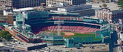 Фенуэй-Парк , домашний стадион команды Бостон Ред Сокс , расположен в районе Фенуэй-Кенмор. | |
| Координаты: 42 ° 20'31,39 "N 71 ° 06'00,91" W / 42,3420528 ° N 71,1002528 ° W | |
| Страна | Соединенные Штаты |
| Состояние | Массачусетс |
| Графство | Саффолк |
| Город | Бостон |
| Область | |
| • Общий | 1,24 квадратных миль (3,2 км 2 ) |
| Население (2010) | 40,898 |
| • Плотность | 32 982,3/кв. миль (12 734,5/км) 2 ) |
| Time zone | UTC-5 (Eastern) |
| ZIP code(s) | 02115, 02215 |
| Area code(s) | 617, 857 |
Фенуэй-Кенмор — официально признанный район Бостона , штат Массачусетс . В административных целях он считается одним районом, но он состоит из множества отдельных частей (Ист-Фенуэй, Западный Фенуэй, Одюбон-Серкл, Кенмор-сквер), которые почти всегда называются «Фенуэй», «Фенуэй», «Кенмор-сквер». , или «Кенмор». Кроме того, район Фенуэй разделен на два микрорайона, обычно называемые Ист-Фенуэй / Симфони и Вест-Фенуэй.
Фенуэй назван в честь Фенуэя , главной улицы, спроектированной Фредериком Лоу Олмстедом . По данным переписи населения Бостона 2010 года, население Фенуэй-Кенмора составляло 40 898 человек. [1] в то время как его земельная площадь была определена в 1,24 квадратных миль (3,2 км2). 2 ). [2]
Расположение
[ редактировать ]
On the east, Fenway–Kenmore is separated from the Back Bay neighborhood by Charlesgate West, the Massachusetts Turnpike, Dalton Avenue and Belvidere Street.[3] The South End is across Huntington Avenue near The First Church of Christ, Scientist headquarters, a major tourist attraction.[citation needed][3] East Fenway (generally south of the Massachusetts Turnpike) is separated from West Fenway by the Muddy River, which flows through the Back Bay Fens and into the Charles River north of Kenmore.[4]
The Longwood Medical Area is sometimes included as a part of Fenway, and is located across the Back Bay Fens from the West Fenway area.[3] To the south of the neighborhood is the Mission Hill area, which is sometimes considered to be part of Roxbury, which continues as the border extends along Ward, Parker, and Ruggles Streets, and the Southwest Corridor.[3] The Kenmore neighborhood is located north and west of Fenway, roughly separated by the Massachusetts Turnpike. Kenmore includes the part of Boston University campus east of the Boston University Bridge,[3] where it meets the Allston neighborhood, although due to the size of the university, it is sometimes considered to be its own neighborhood. Southwest of the Boston University campus and west of the Longwood Medical Area is the town of Brookline.
Throughout the neighborhood are brownstone townhouses, brick walk-ups, and five- to six-story apartment buildings, typically constructed between 1880 and 1930. Small, independently-owned shops are scattered throughout. Major commercial developments are in Kenmore Square and along Brookline Avenue, Beacon Street, Boylston Street, and Huntington Avenue. The baseball stadium Fenway Park is located immediately south of the Turnpike from Kenmore Square. Parts of Boston University, Northeastern University, the Berklee College of Music, and the Boston Conservatory of Music are located in Fenway–Kenmore, and many students reside in the neighborhood. Over the last 20 years almost every residential building in Kenmore has been purchased by Boston University and turned into dorms, especially in the Audubon Circle area between Beacon Street and Commonwealth Avenue.[citation needed]
History
[edit]The Fenway–Kenmore area was formed by land annexed from neighboring Brookline in the 1870s as part of the Brookline-Boston annexation debate of 1873[failed verification] as well as from land filled in conjunction with the creation of landscape architect Frederick Law Olmsted parks in the 1890s.[2]When planned, it was thought that the buildings built upon the Fenway parkway would house high-wealth residents and that the whole area would be a high-class neighborhood.[5] As property values rose, however, it was educational institutions that sprung up along the Fenway's route. By 1907, there were twenty-two educationally focused organizations, including nine college and universities which had made their homes on the Fenway.[5] Residential buildings that were built needed their frontages to be approved by the Park Board so that a "poor looking building [did not] depreciate the value of the whole neighborhood".[6] Additionally, the Board had discretion on whether it felt a proposed building was suitable for frontage along the park and parkway. The hope of these building restrictions was that there would be an improvement in the look of the Fenway compared to neighboring streets.[6]

In the last few years, development in Fenway has picked up, particularly from developer Samuels and Associates.[7] Recent developments include the renovation of the Landmark Center; the 2003 addition of Hotel Commonwealth on the site of the Rathskeller bar; and the 576-unit, 17-floor Trilogy apartment building on Brookline Avenue and Boylston Street. 1330 Boylston, a second high-rise apartment building, was completed in 2008 and contains 210 apartments, 85,000 square feet (7,900 m2) of office space contained within 10 floors and the new home of Fenway Health.
Planned developments include a 24-story mixed use development at the confluence of Boylston Street and Brookline Avenue, likely including retail, dining, and luxury hotel/apartments.[8][9] Other plans include the renovation of the Howard Johnson motel on Boylston Street, to be rehabbed as an upscale hotel. Additionally, developer John Rosenthal is planning to build a complex named One Kenmore over the Mass Pike alongside the Beacon Street Bridge, comprising 525 units in one 17 floor tower and one 20 floor tower. Concerning infrastructure, in 2007 the MBTA renovated the Fenway Green Line stop and in 2014 renovated the nearby Yawkey commuter rail station.[10] Finally, the Museum of Fine Arts, Boston recently completed a $425 million expansion, and the Isabella Stewart Gardner Museum completed construction of a second building.
Street names
[edit]West Fenway features streets named after Scottish cities and towns present in Robert Burns' literary works; Peterborough, Kilmarnock, Queensberry. This was a result of influence by the (Robert) Burns Memorial Association of Boston influencing the city of Boston[11] when a decision was made to simplify the original neighborhood plan by Frederick Law Olmsted's office. As originally planned in 1894,[12] the street naming system was to continue the system originating in the Back Bay of naming streets in alphabetical order. Where the Back Bay proper ends at Hereford Street, the Fenway was to continue Ipswich, Jersey, Kenyon (Kilmarnock), Lansdowne, Mornington, Nottingham, Onslow, Peterborough, Queensberry, Roseberry, Salisbury, Thurlow, Uxbridge, Vivian, Westmeath (Wellesley), (with X omitted), York, and Zetland.[13]
The parkways surrounding the Back Bay Fens, Fenway and Park Drive, are named after various parks which are part of the Emerald Necklace park system. Other streets in Fenway are named after institutions or civic minded patrons within the neighborhood: Palace Road (formerly Worthington Street), Forsyth Way (formerly Rogers Avenue), Evans Way, Forsyth Street, Hemenway Street (formerly Parker Avenue), Agassiz Road (named after Ida Agassiz), Higginson Circle (named after the founder of the Boston Symphony Orchestra), Evans Way (named after the donor of the Evans Wing at the Museum of Fine Arts), Tetlow Street (named after the headmaster of Girls Latin School at its former location), Symphony Road (formerly Batavia Road), St. Stephens Street (St. Stephen's Church became St. Ann's, which is now known as Northeastern University's Fenway Center), Opera Place (the Boston Opera House was demolished in 1958), and Speare Place (formerly a continuation of St. Stephens Street which itself was formerly Falmouth Street).
Demographics
[edit]| Census | Pop. | Note | %± |
|---|---|---|---|
| 1980 | 30,842 | — | |
| 1990 | 32,880 | 6.6% | |
| 2000 | 36,191 | 10.1% | |
| 2010 | 40,989 | 13.3% |
According to the census of 2000 and the City of Boston,[2][14] there were 36,191 people, 12,872 households, and 5,428 families residing in the neighborhood. The population density was 29,186.3 people per square mile (11,268.9/km²). Of the neighborhood's housing structures, 1% were single-family dwellings while 15% had 3–9 units, 16% had 10–19 units, 41% had 20–49 units, and 27% had 50 or more units; there were 13,229 units in total. 91% percent of units were occupied by tenants while 9% were owner-occupied. The average household size was 1.69 people, while the average family size was 2.61 and non-family 1.51.
The racial makeup of the neighborhood was 71% White, 7% Black or African American, 14% Asian, 4% from other races, and 3% from two or more races. Hispanic or Latino of any race were 8% of the population. 21.3% of the population was foreign born.
The neighborhood population consisted of 4% under the age of 18, 63% from 18 to 24, 23% from 25 to 44, 6% from 45 to 64, and 5% who were 65 years of age or older. The median income for a household in the neighborhood was $25,356. 37.3% of the population was below the poverty line, while the unemployment rate was 11.4%.
East Fenway has a large student population due to its proximity to area colleges and universities, while West Fenway, formerly known as a student haven, has seen rising interest from young professionals and families. The Kenmore Square area is mainly commercial with many residential units now owned by Boston University and used as on-campus housing for students.
Race
[edit]| Race | Percentage of 02115 population | Percentage of Massachusetts population | Percentage of United States population | ZIP Code-to-State Difference | ZIP Code-to-USA Difference |
|---|---|---|---|---|---|
| White | 67.2% | 81.3% | 76.6% | –14.1% | –9.4% |
| White (Non-Hispanic) | 60.7% | 72.1% | 60.7% | –11.4% | +0.0% |
| Asian | 15.1% | 6.9% | 5.8% | +8.2% | +9.3% |
| Hispanic | 13.2% | 11.9% | 18.1% | +1.3% | –4.9% |
| Black | 8.9% | 8.8% | 13.4% | +0.1% | –4.5% |
| Native Americans/Hawaiians | 0.3% | 0.6% | 1.5% | –0.3% | –1.2% |
| Two or more races | 3.5% | 2.4% | 2.7% | +1.1% | +0.8% |
| Race | Percentage of 02215 population | Percentage of Massachusetts population | Percentage of United States population | ZIP Code-to-State Difference | ZIP Code-to-USA Difference |
|---|---|---|---|---|---|
| White | 68.1% | 81.3% | 76.6% | –13.2% | –8.5% |
| White (Non-Hispanic) | 61.6% | 72.1% | 60.7% | –10.5% | +0.9% |
| Asian | 20.8% | 6.9% | 5.8% | +13.9% | +15.0% |
| Hispanic | 10.7% | 11.9% | 18.1% | –1.2% | –7.4% |
| Black | 4.1% | 8.8% | 13.4% | –4.7% | –9.3% |
| Native Americans/Hawaiians | 0.1% | 0.6% | 1.5% | –0.5% | –1.4% |
| Two or more races | 3.9% | 2.4% | 2.7% | +1.5% | +1.2% |
Ancestry
[edit]According to the 2012–2016 American Community Survey 5-Year Estimates, the largest ancestry groups in ZIP Codes 02115 and 02215 are:[18][19]
| Ancestry | Percentage of 02115 population | Percentage of Massachusetts population | Percentage of United States population | ZIP Code-to-State Difference | ZIP Code-to-USA Difference |
|---|---|---|---|---|---|
| Irish | 13.43% | 21.16% | 10.39% | –7.73% | +3.04% |
| Italian | 10.57% | 13.19% | 5.39% | –2.61% | +5.18% |
| Chinese | 7.82% | 2.28% | 1.24% | +5.54% | +6.58% |
| German | 7.36% | 6.00% | 14.40% | +1.36% | –7.04% |
| English | 4.89% | 9.77% | 7.67% | –4.88% | –2.77% |
| Polish | 3.36% | 4.67% | 2.93% | –1.31% | +0.42% |
| Russian | 3.20% | 1.65% | 0.88% | +1.55% | +2.33% |
| French | 2.97% | 6.82% | 2.56% | –3.85% | +0.41% |
| Asian Indian | 2.82% | 1.39% | 1.09% | +1.43% | +1.73% |
| Sub-Saharan African | 2.67% | 2.00% | 1.01% | +0.67% | +1.66% |
| American | 2.40% | 4.26% | 6.89% | –1.87% | –4.50% |
| Arab | 2.12% | 1.10% | 0.59% | +1.02% | +1.53% |
| Mexican | 2.00% | 0.67% | 11.96% | +1.33% | –9.96% |
| Puerto Rican | 1.95% | 4.52% | 1.66% | –2.57% | +0.29% |
| French Canadian | 1.79% | 3.91% | 0.65% | –2.12% | +1.13% |
| European | 1.77% | 1.08% | 1.23% | +0.69% | +0.54% |
| Korean | 1.39% | 0.37% | 0.45% | +0.67% | +0.89% |
| Scottish | 1.16% | 2.28% | 1.71% | –1.12% | –0.55% |
| Greek | 1.05% | 1.22% | 0.40% | –0.17% | +0.65% |
| Portuguese | 1.05% | 4.40% | 0.43% | –3.35% | +0.62% |
| Swedish | 1.05% | 1.67% | 1.23% | –0.62% | –0.18% |
| Родословная | Процент 02215 население | Процент Массачусетс население | Процент Соединенные Штаты население | Почтовый индекс в штат Разница | Почтовый индекс в США Разница |
|---|---|---|---|---|---|
| ирландский | 14.45% | 21.16% | 10.39% | –6.70% | +4.07% |
| китайский | 10.81% | 2.28% | 1.24% | +8.53% | +9.57% |
| итальянский | 10.73% | 13.19% | 5.39% | –2.46% | +5.33% |
| немецкий | 9.07% | 6.00% | 14.40% | +3.07% | –5.33% |
| Английский | 5.62% | 9.77% | 7.67% | –4.15% | –2.05% |
| Польский | 4.15% | 4.67% | 2.93% | –0.52% | +1.22% |
| Азиатский Индийский | 3.79% | 1.39% | 1.09% | +2.40% | +2.70% |
| Русский | 3.69% | 1.65% | 0.88% | +2.04% | +2.82% |
| араб | 3.51% | 1.10% | 0.59% | +2.41% | +2.92% |
| Французский | 3.43% | 6.82% | 2.56% | –3.40% | +0.87% |
| Пуэрториканец | 2.87% | 4.52% | 1.66% | –1.65% | +1.21% |
| корейский | 2.62% | 0.37% | 0.45% | +2.25% | +2.17% |
| Мексиканский | 2.22% | 0.67% | 11.96% | +1.55% | –9.74% |
| Греческий | 1.75% | 1.22% | 0.40% | +0.53% | +1.35% |
| Европейский | 1.70% | 1.08% | 1.23% | +0.61% | +0.47% |
| шотландский | 1.70% | 2.28% | 1.71% | –0.59% | –0.02% |
| Французский канадец | 1.69% | 3.91% | 0.65% | –2.21% | +1.04% |
| Американский | 1.60% | 4.26% | 6.89% | –2.66% | –5.29% |
| Шведский | 1.28% | 1.67% | 1.23% | –0.39% | +0.05% |
| Голландский | 1.02% | 0.62% | 1.32% | +0.40% | –0.30% |
Учреждения
[ редактировать ]
Это дом Фенуэй-парка , знаменитой вывески Boston Citgo , площади Кенмор , Бостонского института искусств , Института Форсайта , Массачусетского колледжа фармации и медицинских наук , Северо-Восточного университета , Консерватории Новой Англии , частей Бостонского университета (включая Общежитие Майлса Стэндиша), части Гарвардской медицинской школы , Гарвардской школы стоматологической медицины , Гарвардской школы общественного здравоохранения им. Т. Чана , Музыкального колледжа Беркли , Бостонской консерватории , Массачусетского колледжа искусств , Технологического института Вентворта , Колледжа Симмонса , Уилока Колледж , Эммануэля , Школа фотографии Новой Англии Православный собор Святой Троицы, Музей Изабеллы Стюарт Гарднер и Музей изящных искусств, Бостон .
Транспорт
[ редактировать ]
Район окружен станцией метро MBTA Orange Line Ruggles и следующими MBTA Green Line остановками легкорельсового транспорта :
- Кенмор – B , C , D
- Фенуэй – Д
- Улица Святой Марии – C
- Симфония – Е
- Северо-Восточный университет - E
- Музей изящных искусств – Е
Станция Лансдаун на линии Фрамингем/Вустер расположена пригородной железной дороги MBTA недалеко от Фенуэй-парка и Кенмор-сквер и обслуживается всеми поездами на линии. Фенуэй-Кенмор также обслуживается несколькими автобусами MBTA, соединяющими его с самим городом, а также с прилегающими районами и населенными пунктами.
Что касается дорог, то Фенвэй и Парк-Драйв окружают Фенс. Бойлстон-стрит является основным маршрутом с востока на запад, как и Бикон-стрит ( MA 2 ) и проспект Содружества ( US 20 ), которые пересекаются на Кенмор-сквер . Бруклин-авеню начинается на Кенмор-сквер на этом перекрестке и идет на юго-запад. Хантингтон-авеню ( MA 9 ) находится на южной границе, а Массачусетс-авеню образует восточную границу и является основным маршрутом с севера на юг. Сторроу Драйв - единственная автомагистраль, напрямую обслуживающая район, а ее выездной комплекс Чарльзгейт обеспечивает доступ ко всему району, с пандусами, ведущими на Кенмор-сквер, Бойлстон-стрит и Парк-Драйв. Хотя Массачусетская магистраль пересекает район, к ней нет точек доступа, кроме как в западном направлении только на Массачусетс-авеню и Ньюбери-стрит.
Ссылки
[ редактировать ]- ^ Борелла, Никойя; Марк Мельник (март 2011 г.). «Перепись населения округа планирования Фенуэй-Кенмор 2010 года» (PDF) . Управление по реконструкции Бостона . Архивировано из оригинала (PDF) 29 июля 2012 года . Проверено 11 августа 2011 г.
- ^ Перейти обратно: а б с Сельвараджа, Эсваран; Рольф Гетце; Джим Врабель (15 декабря 2003 г.). «Фенуэй-Кенмор: перепись населения и жилищного фонда 2000 года» (PDF) . Управление по реконструкции Бостона . Архивировано из оригинала (PDF) 29 июля 2012 года . Проверено 5 сентября 2010 г.
- ^ Перейти обратно: а б с д и «Карты Google» . Проверено 17 августа 2012 г.
- ^ «Стратегический план района Ист-Фенуэй» . Архивировано из оригинала 19 января 2013 г. Проверено 17 августа 2012 г.
- ^ Перейти обратно: а б Смит, Альфред Эмануэль (1907). Новый прогноз . Том. 86. Перспективы . п. 895 . Проверено 8 декабря 2009 г.
- ^ Перейти обратно: а б Пибоди, Роберт С.; Джеймс М. Прендергаст; Дэниел Х. Коакли (1912). Годовой отчет Департамента парка . Департамент Бостонского парка . п. 8 . Проверено 9 декабря 2009 г.
- ^ " «Сэмюэлс и партнеры — застройщики Fenway Triangle» . Архивировано из оригинала 27 августа 2009 г. Проверено 2 июля 2009 г. Веб-сайт Samuels and Associates . Получено 2 июля 2009 г.
- ^ " «Просмотры • Новые проекты» . Архивировано из оригинала 19 августа 2009 г. Проверено 2 июля 2009 г. .» CBT Architects . Проверено 2 июля 2009 г.
- ^ « [1] Архивировано 17 марта 2017 г. в Wayback Machine ». Проверено 2 июля 2009 г.
- ^ Ван Сак, Джессика (13 августа 2010 г.). «Жена руководителя MBTA ведет судебный процесс по проекту Fenway» . Бостон Геральд . Архивировано из оригинала 24 августа 2010 года . Проверено 5 сентября 2010 г.
- ^ Бэк-Бэй-Фенс # Статуя Роберта Бернса .28перенесена.29
- ^ См. Файл: Историческая карта Олмстеда Бостон.png.
- ^ «План 1 — Карта и образовательный центр Нормана Б. Левенталя» .
- ^ Департамент парков и отдыха (январь 2008 г.). «План открытого пространства: 2008-2014» (PDF) . Город Бостон . Проверено 6 сентября 2010 г.
- ^ «ОЦЕНКИ ДЕМОГРАФИЧЕСКОГО И ЖИЛЬНОГО НАПРАВЛЕНИЯ ACS на 2012–2016 годы, пятилетние оценки американского сообщества» . Бюро переписи населения США . Проверено 25 августа 2018 г.
- ^ Перейти обратно: а б «Краткие сведения о Массачусетсе от Бюро переписи населения США» . census.gov .
- ^ «ОЦЕНКИ ДЕМОГРАФИЧЕСКОГО И ЖИЛЬНОГО НАПРАВЛЕНИЯ ACS на 2012–2016 годы, пятилетние оценки американского сообщества» . Бюро переписи населения США . Проверено 25 августа 2018 г.
- ^ «ЛЮДИ, СООБЩАЮЩИЕ О ПРОИСХОЖДЕНИИ, 2012–2016 гг., Оценки опроса американского сообщества за 5 лет» . Бюро переписи населения США . Проверено 25 августа 2018 г.
- ^ «ОЦЕНКИ ДЕМОГРАФИЧЕСКОГО И ЖИЛЬНОГО НАПРАВЛЕНИЯ ACS на 2012–2016 годы, пятилетние оценки американского сообщества» . Бюро переписи населения США . Проверено 25 августа 2018 г.