Река Св. Лаврентия

Река Св. Лаврентия
| |
|---|---|
 | |
 Великие озера/ул. Лоуренс водосбор | |
| Этимология | Святой Лоуренс из Рима |
| Расположение | |
| Страна | Канада , США |
| Провинции | Онтарио , Квебек |
| Состояние | Нью-Йорк |
| Территории | Estiishinabewaki ; Страны Хауденосауни ; Нитаскинан ; Newentsï ; Нитассанан ; Донленд округа |
| Физические характеристики | |
| Источник | Озеро Онтарио |
| • расположение | Кингстон, Онтарио / Кейп Винсент, Нью -Йорк |
| • Координаты | 44 ° 06′N 76 ° 24′W / 44,100 ° N 76,400 ° W |
| • высота | 74,7 м (245 футов) |
| Рот | Залив Святого Лаврентия / Атлантический океан |
• расположение | Квебек , Канада |
• Координаты | 49 ° 30'N 64 ° 30'W / 49,500 ° N 64 500 ° W |
• высота | 0 м (0 футов) |
| Длина | 500 км (310 миль), за исключением устья. C. 928 км, если включено. |
| Размер бассейна | 1 344 200 км 2 (519 000 кв. МИ) [ 1 ] |
| Увольнять | |
| • расположение | Под рекой Сагуэнай [ 2 ] |
| • средний | 16 800 м 3 /s (590 000 с Ft/s) [ 2 ] |
| Увольнять | |
| • расположение | Квебек Сити |
| • средний | 12,101 м 3 /s (427 300 с Ft/S) |
| Увольнять | |
| • расположение | Монреаль |
| • средний | 10000 м 3 /s (350 000 с Ft/S) |
| • Максимум | 17 000 м 3 /s (600 000 с Ft/s) |
| Увольнять | |
| • расположение | Озеро Онтарио , Кингстон |
| • средний | 7,410 м 3 /s (262 000 с Ft/s) |
Река Св. Лаврентия |
|---|
Река Св. Лаврентия ( французский : Fleuve Saint-Laurent [flœv Sɛ̃lɔʁ̃] )-это большая международная река в средних широтах Северной Америки, соединяющей Великие озера в северной Атлантической океане . Его воды протекают в северо -восточном направлении от озера Онтарио до залива Святого Лаврентия , пересекая Онтарио и Квебек в Канаде и Нью -Йорке в Соединенных Штатах. Секция реки разграничивает границу Канады -США .
Будучи основным дренажным оттоком в бассейне Великих озер , Св. Лаврентия имеет второе место в любой реке в Северной Америке (после реки Миссисипи ) и 16-м по величине в мире. Утег Святого Лаврентия часто называют учеными самыми крупными в мире. Значительные природные достопримечательности реки и устья включают 1864 речные острова тысячи островов , находящихся под угрозой исчезновения китов Сагуэне. Лоуренс Морский парк и известняковые монолиты архипелага Минна .
Долгое транспортное маршрут к коренным народам , река Св. Лаврентия сыграла ключевую роль в истории Канады и в развитии таких городов, как Монреаль и Квебек . Река остается важным маршрутом судоходства в качестве основы моря Святого Лаврентия , системы замка и каналов, которая позволяет мировому морскому движению добраться до внутренних портов водного пути Великих озер .
Этимология
[ редактировать ]Река была названа различными именами местными первыми нациями . Начиная с 16 -го века, французские исследователи посетили то, что сейчас является Канадой, и дали такие имена реки, как Grand Fleuve de Hochelaga и Grande Rivière du Canada , [ 3 ] где Fleuve и Rivière находятся два французских слова ( Fleeve - это река, которая течет в море).
Нынешнее название реки использовалось с 1604 года, когда оно было записано на карте Сэмюэлем де Шамплейном [ 3 ] Шамплейн выбрал имена Grande Riviere de Sainct Laurens и Fleuve Sainct Laurens в своих работах, вытеснив более ранние имена. [ 3 ] На современном французском языке это название визуализировано как флеув-Сен-Лавр . Имя Сен-Лауран (Сент-Лоуренс) первоначально применялось в одноименном заливе Жаком Картье после его прибытия в регион 10 августа праздника для Святого Лоуренса в 1535 году. [ 3 ]
Сегодня река все еще знает коренных народов несколькими различными именами. Инну-аимилун , язык нитассинана , ссылается на него как Wepitukujaw sipo / waspìtìtùkwiyaht sīpu ; [ 3 ] [ 4 ] Абенаки , называют это Moliantegok / Moliantekw ("Montréal River") [ 3 ] Kchitegw / ktsitekw / gicitegw ("Великая река"), [ 4 ] OS8GENAIZI / WSOGENAISIPE /Wsogenaisibo. [ 4 ] Могавк в называет его Каниме'Кехе как Wediatokeni , Raotenaneara , [ 3 ] Ken'tarókwen , [ 5 ] или kaniatarowanénhne ; [ 6 ] ТУССАРОР («Большой Керрен » ЗАВЕРСТВО КАПАВАВА -КЕКЕТ ИЛИ КАЙАНАРОРАННА ); [ 7 ] Algonquins (или Omàmiwininiwak) называют это «пешеходной дорожкой» или магтогеком [ 3 ] [ 8 ] или kitcikanii sipi , «большая водная река»; [ 4 ] [ 9 ] Гурон -Вендаты называют его Lada8anna или Laooendaooena ; [ 4 ] и это направление . Micha его ( река Хю »)
География
[ редактировать ]


С истощением моря Шамплена , из -за отскок континента с последнего ледникового максимума , была сформирована река Святого Лаврентия. Шамплейнское море длилось около 13 000 лет назад до 10 000 лет назад и в течение этого времени постоянно сокращалось, процесс, который продолжается сегодня. [ 10 ] [ 11 ] Глава реки Св. Лаврентия, недалеко от озера Онтарио, является домом для тысяч островов . [ 12 ]
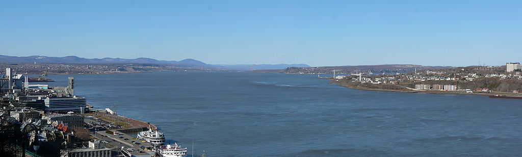
Сегодня река Св. Лаврентия начинается у оттока озера Онтарио и потоков, прилегающих к Гананоке , Броквиллу , Морристауне , Огденсбурге , Массене , Корнуоллу , Монреалу , Труа-Ривьеру и Квебеку , прежде чем выйти в залв . дано в качестве крупнейшего лимана в мире. [ 13 ] Устье начинается у восточной оконечности Иль -д'Орлеанса , прямо вниз по течению от города Квебека. [ 2 ] Река становится приливным вокруг города Квебек. [ 14 ]
The St. Lawrence River runs 3,058 kilometres (1,900 mi) from the farthest headwater to the mouth and 1,197 km (743.8 mi) from the outflow of Lake Ontario. These numbers include the estuary; without the estuary, the length from Lake Ontario is c. 500 km (c. 300 mi). The farthest headwater is the North River in the Mesabi Range at Hibbing, Minnesota. Its drainage area, which includes the Great Lakes, the world's largest system of freshwater lakes, is 1,344,200 square kilometres (518,998.5 sq mi), of which 839,200 km2 (324,016.9 sq mi) is in Canada and 505,000 km2 (194,981.6 sq mi) is in the United States. The basin covers parts of Ontario and Quebec in Canada, parts of Minnesota, Wisconsin, Illinois, Indiana, Ohio, Pennsylvania, New York, Vermont, and nearly the entirety of the state of Michigan in the United States. The average discharge below the Saguenay River is 16,800 cubic metres per second (590,000 cu ft/s). At Quebec City, it is 12,101 m3/s (427,300 cu ft/s). The average discharge at the river's source, the outflow of Lake Ontario, is 7,410 m3/s (262,000 cu ft/s).[2]
The St. Lawrence River includes Lake Saint Francis at Salaberry-de-Valleyfield, Lake Saint-Louis south of Montreal and Lake Saint Pierre east of Montreal. It encompasses four archipelagoes: the Thousand Islands chain near Alexandria Bay, New York and Kingston, Ontario; the Hochelaga Archipelago, including the Island of Montreal and Île Jésus (Laval); the Lake St. Pierre Archipelago (classified a biosphere world reserve by the UNESCO in 2000)[15] and the smaller Mingan Archipelago. Other islands include Île d'Orléans near Quebec City and Anticosti Island north of the Gaspé. It is the second longest river in Canada.
Lake Champlain and the Ottawa, Richelieu, Saint-Maurice, Saint-François, Chaudière and Saguenay rivers drain into the St. Lawrence.
The St. Lawrence River is in a seismically active zone where fault reactivation is believed to occur along late Proterozoic to early Paleozoic normal faults related to the opening of the Iapetus Ocean. The faults in the area are rift-related and comprise the Saint Lawrence rift system.
According to the United States Geological Survey, the St. Lawrence Valley is a physiographic province of the larger Appalachian division, containing the Champlain section.[16] However, in Canada, where most of the valley is, it is instead considered part of a distinct St. Lawrence Lowlands physiographic division, and not part of the Appalachian division at all.[17]
Sources and tributaries
[edit]The source of the North River in the Mesabi Range in Minnesota (Seven Beaver Lake) is considered to be the source of the St. Lawrence River. Because it crosses so many lakes, the water system frequently changes its name. From source to mouth, the names are:
The St. Lawrence River also passes through Lake Saint-Louis and Lake Saint-Pierre in Quebec.
Biodiversity
[edit]According to the David Suzuki Foundation, the diversity of the St. Lawrence River includes[20]
- 19 species of marine mammals
- More than 230 species of birds
- Nearly 35 species of amphibians and reptiles
- 200 species of freshwater and aquatic fish salty (including 19 sharks and rays)
- 2200 invertebrates in the estuary and its gulf (sponges, jellyfish, corals, crustaceans, etc.)
- Nearly 2000 vascular plants[21]
Marine mammals
[edit]Large marine mammals travel in all the seas of the earth, the research and observations of these giants concern fishermen and shipping industry, exercise a fascination and a keen interest for laymen and, subjects of endless studies for scientists from Quebec, Canada and around the world.[22][23][24]
Thirteen species of cetaceans frequent the waters of the estuary and the Gulf of St. Lawrence.[25]
1. Hyperoodon ampullatus. — Hypéroodon boreal, Hypéroodon arctique. — (Northern Bottlenose Whale).
2. Delphinapterus leucas. — Béluga, Bélouga, Baleine blanche, Dauphin blanc, Marsouin blanc. — (Beluga Whale). (Endangered)[26][27]
3. Physeter macrocephalus. — Grand cachalot, Cachalot, Cachalot macrocéphale. — (Sperm whale).
4. Lagenorhynchus acutus. — Lagénorhynque à flancs blancs, Dauphin à flancs blancs. — (Atlantic white-sided dolphin).
5. Lagenorhynchus albirostris. — Dauphin à nez blanc, Dauphin à bec blanc, Lagénorhynque à bec blanc. — (White-beaked dolphin).
6. Orcinus orca. — Orque, Épaulard. — (Killer Whale).
7. Globicephala melas. — Globicéphale commun, Globicéphale noir, Dauphin pilote. — (Long-Finned Pilot Whale).
8. Phocoena Phocoena. — Marsouin commun, Cochon de mer, Dieu des mers. — (Harbour Porpoise).
9. Eubalaena glacialis. — Baleine franche de l'Atlantique nord, Baleine noire de l'Atlantique nord, Baleine de Biscaye. — (North Atlantic Right Whale).(Endangered)[28]
10. Balaenoptera acutorostrata. — Petit rorqual. — (Minke whale).
11. Balaenoptera musculus. — Baleine bleue, Rorqual bleu. — (Blue whale). (Endangered)[29]
12. Megaptera novaeangliae. — Rorqual à bosse, Baleine à bosse. — (Humpback whale).
13. Balaenoptera physalus. — Rorqual commun. — (Fin whale).
- Estuary and Gulf of St. Lawrence marine fauna
-

-
![North of Anticosti Island [30]](//upload.wikimedia.org/wikipedia/commons/thumb/9/95/Rorqual_070.jpg/240px-Rorqual_070.jpg) North of Anticosti Island [30]
North of Anticosti Island [30] -
 Humpback whales, females and cubs, North Anticosti Island
 -
 Humpback whales, dorsals, pectoral fins, North Antiscosti Island
 -
 Whale, Gaspé Bay

![North of Anticosti Island [30]](http://upload.wikimedia.org/wikipedia/commons/thumb/9/95/Rorqual_070.jpg/240px-Rorqual_070.jpg)


History
[edit]

First Nations
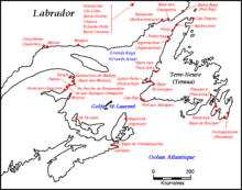
[edit]Flowing through and adjacent to numerous Indigenous homelands, the large river was always and remains to this day a primary thoroughfare for many peoples. Beginning in Dawnland at the Gulf of St. Lawrence, the river borders Mi'kma'ki[31] in the South (what is today known as the Canadian Maritimes), and Nitassinan in the North, the national territory of the Innu people.[32] On the south shore beyond the Mi'kmaw district of Gespe'gewa'ki,[31] the river passes Wolastokuk (the Maliseet homeland), Pαnawαhpskewahki (the Penobscot homeland), and Ndakinna (the Abenaki homeland).[33] Continuing, the river passes through the former country of the St. Lawrence Iroquois and then three of the six homelands of the Haudenosaunee: the Mohawk or Kanienʼkehá꞉ka, the Oneida or Onyota'a:ka, and the Onondaga or Onöñda’gaga’.[33]
In the early 17th century, the Huron-Wendat Nation migrated from their original country of Huronia to what is now known as Nionwentsïo centred around Wendake.[34][35] Nionwentsïo occupies both the north and south shores of the river,[34] overlapping with Nitassinan and the more western Wabanaki or Dawnland countries.[33] Adjacent on the north shore is the Atikamekw territorial homeland of Nitaskinan[36][37] and, upstream, the further reaches of Anishinaabewaki, specifically the homelands of the Algonquin and Mississauga Nations.[33]
European exploration
[edit]The Norse explored the Gulf of St. Lawrence in the 11th century and were followed by fifteenth- and early sixteenth-century European mariners, such as John Cabot, and the brothers Gaspar and Miguel Corte-Real. The first European explorer known to have sailed up the St. Lawrence River itself was Jacques Cartier. At that time, the land along the river described as "about two leagues, a mountain as tall as a heap of wheat" was inhabited by the St. Lawrence Iroquoians. During Cartier's second voyage in 1535, because Cartier arrived in the estuary on Saint Lawrence's feast day 10 August, he named it the Gulf of Saint Lawrence.[38] [39]
The St. Lawrence River is today partly within the U.S. and as such is that country's sixth oldest surviving European place-name.[40]
Early colonists
[edit]The earliest regular Europeans in the area were the Basques, who came to the St Lawrence Gulf and River in pursuit of whales from the early 16th century. The Basque whalers and fishermen traded with indigenous Americans and set up settlements, leaving vestiges all over the coast of eastern Canada and deep into the St. Lawrence River. Basque commercial and fishing activity reached its peak before the Armada Invencible's disaster (1588), when the Basque whaling fleet was confiscated by King Philip II of Spain. Initially, the whaling galleons from Labourd were not affected by the Spanish defeat.
Until the early 17th century, the French used the name Rivière du Canada to designate the St. Lawrence upstream to Montreal and the Ottawa River after Montreal. The St. Lawrence River served as the main route for European exploration of the North American interior, first pioneered by French explorer Samuel de Champlain.
Colonial control
[edit]Control of the river was crucial to British strategy to capture New France in the Seven Years' War. Having captured Louisbourg in 1758, the British sailed up to Quebec the following year thanks to charts drawn up by James Cook. British troops were ferried via the St. Lawrence to attack the city from the west, which they successfully did at the Battle of the Plains of Abraham. The river was used again by the British to defeat the French siege of Quebec under the Chevalier de Lévis in 1760.
In 1809, the first steamboat to ply its trade on the St. Lawrence was built and operated by John Molson and associates, a scant two years after Fulton's steam-powered navigation of the Hudson River. The Accommodation with ten passengers made her maiden voyage from Montreal to Quebec City in 66 hours, for 30 of which she was at anchor. She had a keel of 75 feet, and a length overall of 85 feet. The cost of a ticket was eight dollars upstream, and nine dollars down. She had berths that year for twenty passengers.[41] Within a decade, daily service was available in the hotly-contested Montreal-Quebec route.[42]
Because of the virtually impassable Lachine Rapids, the St. Lawrence was once continuously navigable only as far as Montreal. Opened in 1825, the Lachine Canal was the first to allow ships to pass the rapids. An extensive system of canals and locks, known as the St. Lawrence Seaway, was officially opened on 26 June 1959 by Elizabeth II (representing Canada) and President Dwight D. Eisenhower (representing the United States). The Seaway (including the Welland Canal) now permits ocean-going vessels to pass all the way to Lake Superior.[43]
Modern Canada
[edit]During the Second World War, the Battle of the St. Lawrence involved submarine and anti-submarine actions throughout the lower St. Lawrence River and the entire Gulf of St. Lawrence, Strait of Belle Isle and Cabot Strait from May to October 1942, September 1943, and again in October and November 1944. During this time, German U-boats sank several merchant marine ships and three Canadian warships.
In the late 1970s, the river was the subject of a successful ecological campaign (called "Save the River"), originally responding to planned development by the United States Army Corps of Engineers. The campaign was organized, among others, by Abbie Hoffman.[44]
Culture
[edit]The culture of Quebec bathes in the water of the St. Lawrence River: novels, song, poetry, epic, legends, history, and tales not to mention the countless scientific works and oral traditions of the First Nations.
- Gatien Lapointe, Ode au Saint-Laurent, Éditions du Jour, Montréal, 1963, Paradis, A. (1963), report, 3 pages.[45]
- Anne Hébert's novel Kamouraska, won the French Booksellers Prize 1970[46]
- Pierre Morency, poet, L'Oeil américain, winner of the 1989 Governor General's Awards, Lumière des oiseaux, winner of the 1992 Governor General's Awards, La Vie entière — Histoires naturelles du Nouveau Monde, winner of the 1997 Governor General's Awards
- Songs "Suzanne" by Leonard Cohen, poet and musician
- Frère Marie-Victorin, Flore laurentienne, is the scientific inventory of vascular plant resources growing spontaneously in the St. Lawrence River valley, Bros. of the Christian Schools in 1935
So much more
[edit]
- Dans les yeux d'Émilie" by Joe Dassin.[citation needed] - The river was the setting for the Canadian television drama series Seaway. - River has also been portrayed in paintings, notably by the Group of Seven. - It is the namesake of Saint-Laurent Herald at the Canadian Heraldic Authority. - In 1980, Jacques Cousteau filmed Cries from the Deep and St. Lawrence: Stairway to the Sea.[47] - The 1993 Canadian animated short film The Mighty River was about the river. - The novel and film Black Robe are set primarily on the St. Lawrence River during the 17th century. - The 1941 children's book Paddle-to-the-Sea, and the film Paddle to the Sea, involve passage through the St. Lawrence River, etc...
See also
[edit]- Gulf of St. Lawrence
- Estuary of St. Lawrence
- Lac Saint-Pierre
- Lachine Rapids
- RMS Empress of Ireland
- St. Lawrence Seaway
- NEPCO 140 Oil Spill
- Boldt Castle
- Container on barge
- Grindstone Island
- Jorstadt Castle
- Wellesley Island
- Maison Drouin
- List of longest rivers of the United States (by main stem)
- List of longest rivers of Canada
- List of Quebec rivers
- List of Ontario rivers
- List of New York rivers
- List of crossings of the St. Lawrence River
References
[edit]- ^ "Rivers". Atlas of Canada. Natural Resources Canada. Archived from the original on 22 January 2013.
- ^ Jump up to: a b c d Benke, Arthur C.; Cushing, Colbert E. (2005). Rivers of North America. Academic Press. pp. 989–990. ISBN 978-0-12-088253-3.
- ^ Jump up to: a b c d e f g h "Fleuve Saint-Laurent". Commission de toponymie Québec. Gouvernement du Québec. Retrieved 28 December 2021.
- ^ Jump up to: a b c d e Lozier, Jean-François (2018). Flesh Reborn: The Saint Lawrence Valley Mission Settlements through the Seventeenth Century. Montréal: McGill-Queens University Press. p. 306. ISBN 9780773553989. Retrieved 28 December 2021.
- ^ Doolittle, Benjamin (25 August 2016). "St. Lawrence (Upper river)". Kanienʼkéha Dictionary. Retrieved 28 December 2021.
- ^ Doolittle, Benjamin (25 August 2016). "St. Lawrence, USA & CA". Kanienʼkéha Dictionary. Retrieved 28 December 2021.
- ^ Rudes, B. Tuscarora English Dictionary Toronto: University of Toronto Press, 1999
- ^ Toussaint, Jean-Patrick. "Il était une fois un fleuve... et nous". Agence Science-Presse (in French). Retrieved 28 December 2021.
- ^ Cuoq, Jean André (1886). Lexique de la langue algonquine (in French). Montréal: J. Chapleau. Retrieved 28 December 2021.
- ^ Lake Champlain Basin Atlas: Geology Page Archived 20 July 2008 at the Wayback Machine
- ^ Miller, William J. (2015). Geology: The Science of the Earth's Crust (Illustrations). P. F. Collier & Son Company. p. 37. GGKEY:Y3TD08H3RAT.
- ^ "St. Lawrence River Ecosystem". Save The River! Thousand Islands - Clayton NY on the St. Lawrence River. Retrieved 9 February 2023.
- ^ "Estuary - National Geographic Society". nationalgeographic.org. Retrieved 16 August 2022.
- ^ Dawson, Samuel Edward (October 2007). The Saint Lawrence: Its Basin and Border-lands. Heritage Books. p. 36. ISBN 978-0-7884-2252-2. Retrieved 21 March 2011.
- ^ Lac Saint-Pierre et son archipel Archived 2 April 2015 at the Wayback Machine. Pleinairalacarte.com (2008-11-07). Retrieved 2013-07-12.
- ^ "Physiographic divisions of the conterminous U.S." U.S. Geological Survey. Retrieved 6 December 2007.
- ^ "Physiographic Regions of Canada" (PDF). Natural Resources Canada. Natural Resources Canada. Archived (PDF) from the original on 21 October 2017. Retrieved 18 February 2017.
- ^ "Saint Lawrence River and Seaway". Encyclopædia Britannica. Retrieved 7 September 2009.
- ^ "Saint Lawrence". MSN Encarta. Archived from the original on 6 July 2008. Retrieved 7 September 2009.
- ^ "The St. Lawrence, this great river that flows within us (David Suzuki Foundation)" (PDF). Wild nature in the heart of Quebec and America (in French). Fondation David Suzuki. 7 June 2023. Retrieved 1 September 2024.
... colossal reserve of resources natural and landscape matrix grandiose, the St. Lawrence is first and above all a source of life, a life astonishing diversity
- ^ Frère Marie-Victorin (1935). "Flore laurentienne" (in French). florelaurentienne.com. Retrieved 1 September 2024.
inventory of natural vascular plant resources valley of the great Saint Lawrence River - Quebec
- ^ "Saguenay–St. Lawrence Marine Park". Government Quebec - Government of Canada. 2024. Retrieved 19 August 2024.
More than 2,200 species frequent these waters, including species at risk such as the beluga whale, the blue whale and the Barrow's goldeneye.
- ^ "International Marine Mammal Project (IMMP)". Earth Island Institute. 2024. Retrieved 19 August 2024.
We have achieved victories for marine mammals around the world and work to make the oceans safe for whales, dolphins and marine life.
- ^ Stéphane Plourde (7 November 2017). "Right Whales: A Look Back on the Summer of 2017". Gouvernement of Canada. InfoOceans - New wave. Retrieved 19 August 2024.
The North Atlantic right whale is an endangered species - Over the coming months, the Government of Canada will meet with representatives of the fishing and shipping industries, Aboriginal communities, whale experts and scientists, as well as the US National Oceanographic and Atmospheric Administration (NOAA).
- ^ "The Species of the St. Lawrence". Whales Online, magazine and encyclopedia. Group for Research and Education on Marine Mammals (GREMM). July 2024. Retrieved 10 August 2024.
The different species of seals and whales are all mammal species. © GREMM
- ^ COSEPAC (27 May 2021). "Béluga - Delphinapterus leucas" (PDF). Wildlife species; Biodiversity; Species at risk; beluga. p. 132. Retrieved 29 August 2024.
We fear that the increase in maritime traffic, facilitated by climate change, is modifying the nature of the acoustic environment of the population. This population can correspond, or almost corresponds, to the criteria of the category "species threatened »
- ^ V. Lesage; M. C. S. Kingsley (1995). "Assessment of knowledge of the beluga population (Delphinapterus leucas) from the St. Lawrence" (PDF) (in English and French). Fisheries and Oceans Canada. p. 54. Retrieved 29 August 2024.
The population of St. Lawrence belugas is relatively sedentary given that the most distant seasonal areas are not separated only by a few hundred kilometers
- ^ Marie-Sophie Giroux (2024). "A black whale in sight! Please call Marine Mammal Emergencies!". Retrieved 28 August 2024.
Since 1998, several sightings of right whales have also been reported elsewhere in the St. Lawrence: Magdalen Islands, Baie des Chaleurs, Basse-Côte-Nord and the St. Lawrence estuary, in the Saguenay—St. Lawrence Marine Park.
- ^ "Blue Whale (Balaenoptera musculus)" (PDF). Environment Canada - o Canadian Wildlife Service. Committee on the status of endangered wildlife in Canada (COSEWIC). 22 August 2003. Retrieved 29 August 2024.
Today, the biggest threats for this species come from ship strikes, disturbance from increasing whale watch activity, entanglement in fishing gear, and pollution.
- ^ "Mingan Island Cetacean Study (MICS)". 2024. Retrieved 11 August 2024.
The principal study areas include the Quebec North Shore in the Mingan Island / Anticosti region, the Gaspe Peninsula and St. Lawrence Estuary.
- ^ Jump up to: a b "Gespe'gewa'gi : Our District Territory". Mi’gmawei Mawiomi Secretariat. Mi’gmawei Mawio’mi. Retrieved 28 December 2021.
- ^ Nitassinan: The Innu Struggle to Reclaim Their Homeland, Douglas & McIntyre, December 1991, 240pp, by Marie Wadden, ISBN 978-1-55365-731-6, (book link) Archived 2013-01-21 at archive.today
- ^ Jump up to: a b c d "Territories". native-land.ca. Retrieved 28 December 2021.
- ^ Jump up to: а беременный "Carte du nionwents Ки" . Нация Гурон-Вендат . Нация Гуронн-Вендат . Получено 28 декабря 2021 года .
- ^ J. Jaenen , Канадская энциклопедия Канада 28 2021декабря
- ^ «Аттикамекс атакует безразличие Квебека» . Le Devoir (по -французски). 9 сентября 2014 года . Получено 20 апреля 2017 года .
- ^ «Atikamekw объявляет о своем суверенитете» . Radio-Canada.ca (по-французски). 8 сентября 2014 года . Получено 20 апреля 2017 года .
- ^ Джонсон, Уильям Генри (20 мая 2007 г.). Французские пути в Северной Америке . Получено 27 февраля 2011 года - через проект Гутенберг.
- ^ Бидо, Мишель (1986). Жак Картье: Отношения (по -французски). Прессы Университета Монреаля. стр. 130–131 . Получено 20 ноября 2021 года - через библиотеку и национальный архив Квебека.
- ^ Испанские имена Флорида , сухой Тортугас , Кейп Канаверал , Аппалач и Калифорния появились ранее ..... Из учетных записей испанского историка Антонио де Эррера Y Tordesillas опубликованы в 1601 году - Стюарт, Джордж (1945). Названия на земле: исторический отчет о напоминании о местах в Соединенных Штатах . Нью -Йорк: Рэндом Хаус. С. 11–17, 29.
- ^ Кевин С Гриффин (2013). «Святой Лоуренс Сага: история парохода Кларк - перед Кларком Париком» (PDF) . С. 2 из 132 . Получено 2 сентября 2024 года .
Первым пароходом, работающим на реке Сент -Лоуренс, было размещение парохода Джона Молсона, построенное в Монреале в 1809 году.
- ^ Денисон 1955 , с. 91
- ^ «Святой Лоуренс Морский путь, жизненно важный водный путь» . Великие озера Святой Лоуренс . Великие озера и система морской дорожки реки Св. Лаврентия. 2024 . Получено 30 августа 2024 года .
Согласно специальному отчету, составленному BMO Capital Markets, восемь штатов и две провинции, которые граничат с Великими озерами/Св. Система Lawrence Seaway оказывает огромное экономическое воздействие в Северной Америке.
- ^ "Спасите реку!" Полем 1 ноября 2008 года. Архивировано с оригинала 1 ноября 2008 года . Получено 27 мая 2019 года .
- ^ Андре Паради (1963). «Ода Св., Лоуренс, поэзия» (PDF) (по -французски). Издание Du Jour, Montréal . Получено 12 сентября 2024 года .
.. Река никогда не обретала форму с таким большим количеством правды в одном из наших поэтов. Гатен Лапойнте, безусловно, написал там очень красивое стихотворение, вам придется постепенно слушать песню.
- ^ Энн Хеберт (1970). "Камураска, роман" (по -французски). Au Editions du Seuil. п. 251 . Получено 12 сентября 2024 года .
.Elisabeth D'aulnières женат на Антуине Тасси, владельце Лартистика Камураски, у ворот Бас-дю-Флеира
- ^ Ohayon, Albert (2009). «Когда Кусто приехал в Канаду» . Nfb.ca. Национальный совет по фильмам Канады . Получено 25 октября 2009 года .
Библиография
[ редактировать ]- Крейтон, Дональд Грант (2002) [1937], Империя Святого Лаврентия: исследование в области торговли и политики (Перепечатка), Университет Торонто Пресс, ISBN 0-8020-8418-4
- Доусон, Сэмюэль Эдвард (2003), Святой Лоуренс: его бассейн и границы , книги наследия, ISBN 0-7884-2252-9
- Денисон, Меррилл (1955). Ячмень и поток: история Молсона . McClelland & Stewart Limited.
- Эллис, Уильям С. (май 1980). «Канадское шоссе до моря». National Geographic . Тол. 157, нет. 5. С. 586–623. ISSN 0027-9358 . OCLC 643483454 .
- McNeese, Tim (2005), The St. Lawrence River , Publishers Chelsea House, ISBN 0791082458
- Parham, Claire Puccia (2009), Seaway и Power Project St. Lawrence: устная история величайшего строительного шоу на Земле , Сиракузский университет, ISBN 978-0-8156-0913-1
- Стэгг, Рональд (2010), «Золотая мечта: история Сент -Луиса». Lawrence Seaway , Dundurn Press, ISBN 978-1-55002-887-4
Внешние ссылки
[ редактировать ]- Меховые маршруты каноэ в Канаде/Then и Now , 1969, Эрик У. Морс, MA; FRGS, 121 с.
- Святой Лоуренс его бассейн и границы , 1905, доктор Се Доусон, 584 с.
- Комиссия парков Св. Лаврентия (Онтарио)
- Система морской дороги с ограниченным озером
- Радио СПИД к морской навигации 2024 , радиопад для морской навигации 2024, (Атлантика, Св. Лаврентия, Великие озера, Лейк Виннипег, Арктика и Тихоокеанский регион) рыболовство и океаны Канада , 298 страниц
- Безопасный проход: СПИД для навигации по Св. Лаврентии - историческое эссе, иллюстрируемое рисунками и фотографиями
- Аннотированная библиография в округе Св. Лаврентия и северной части Нью -Йорка.
- Международный совет по контролю над рекой Св. Лаврентия Архивировал 23 июля 2013 года на машине Wayback
- Река Святой Лоуренс из канадской энциклопедии архивировал 21 сентября 2017 года на машине Wayback
- Река Св. Лаврентия Кэм
- Смотреть документальный фильм Жака Кусто, Св. Лаврентия: лестница к морю
- Пароходы сэр Джеймс Кемп и лорд Далхаузи на реке Св. Лаврентия, Верхняя Канада, в 1833 году, диджей Кеннеди, Историческое общество Пенсильвании, архивировав 22 декабря 2016 года на машине Wayback
Великие озера Северной Америки |
|---|
- Река Святой Лоуренс
- Североамериканские водоразделы Атлантического океана
- Физиографические провинции
- Международные реки Северной Америки
- Реки Нью -Йорка (штат)
- Реки Онтарио
- Канада - Университетские штаты Граница
- Реки Монтереги
- Реки Капитале Национал
- Реки округа Св. Лаврентия, Нью -Йорк
- Регионы Нью -Йорка (штат)
- Реки Квебека