Jump to content

List of cities and towns in Albania

This is a list of cities and towns in Albania categorised by municipality, county and population, according to the criteria used by the Institute of Statistics (INSTAT). As of 2014, there were 74 cities classified as urban areas and 2,972 villages as rural areas in Albania.[1] The legislation of Albania provides no official classification on the criteria of how to define a city or urban area.[1] Furthermore, according to the methodology for cities conducted by the Organisation for Economic Co-operation and Development (OECD), five areas, including Tirana, Durrës, Elbasan, Shkodër and Vlorë, can be classified as urban audit cities[a].[1][2]

Cities and towns in Albania belong to the following size ranges in terms of the number of population:

List

[edit]
City[1]MunicipalityCountyPopulation (2011)Geographic coordinatesRef.
Bajram CurriTropojëKukës5,34042°21′29″N 20°4′33″E / 42.35806°N 20.07583°E / 42.35806; 20.07583 (Bajram Curri)[3]
BajzëMalësi e MadheShkodër2,34642°16′35″N 19°25′56″E / 42.27639°N 19.43222°E / 42.27639; 19.43222 (Bajzë)
BallshMallakastërFier7,65740°36′3″N 19°44′11″E / 40.60083°N 19.73639°E / 40.60083; 19.73639 (Ballsh)[4]
BeratBeratBerat36,49640°42′24″N 19°57′8″E / 40.70667°N 19.95222°E / 40.70667; 19.95222 (Berat)[5]
BilishtDevollKorçë6,25040°37′16″N 20°59′17″E / 40.62111°N 20.98806°E / 40.62111; 20.98806 (Bilisht)[6]
BulqizëBulqizëDibër8,17741°29′30″N 20°13′19″E / 41.49167°N 20.22194°E / 41.49167; 20.22194 (Bulqizë)[7]
BurrelMatDibër10,86241°36′34″N 20°0′44″E / 41.60944°N 20.01222°E / 41.60944; 20.01222 (Burrel)[7]
CërrikCërrikElbasan6,69541°1′36″N 19°59′21″E / 41.02667°N 19.98917°E / 41.02667; 19.98917 (Cërrik)[8]
ÇorovodëSkraparBerat4,05140°30′15″N 20°13′38″E / 40.50417°N 20.22722°E / 40.50417; 20.22722 (Çorovodë)[5]
DelvinëDelvinëVlorë5,75439°57′17″N 20°5′56″E / 39.95472°N 20.09889°E / 39.95472; 20.09889 (Delvinë)[9]
DivjakëDivjakëFier8,44540°59′47″N 19°31′57″E / 40.99639°N 19.53250°E / 40.99639; 19.53250 (Divjakë)[4]
DurrësDurrësDurrës113,24941°18′40″N 19°26′21″E / 41.31111°N 19.43917°E / 41.31111; 19.43917 (Durrës)[10]
ElbasanElbasanElbasan78,70341°6′41″N 20°4′49″E / 41.11139°N 20.08028°E / 41.11139; 20.08028 (Elbasan)[8]
ErsekëKolonjëKorçë3,74640°20′24″N 20°40′54″E / 40.34000°N 20.68167°E / 40.34000; 20.68167 (Ersekë)[6]
FierFierFier55,84540°43′30″N 19°33′26″E / 40.72500°N 19.55722°E / 40.72500; 19.55722 (Fier)[4]
FierzëTropojëKukës1,60742°15′47″N 20°1′30″E / 42.26306°N 20.02500°E / 42.26306; 20.02500 (Fierzë)[3]
FiniqFiniqVlorë1,33339°54′25″N 20°3′32″E / 39.90694°N 20.05889°E / 39.90694; 20.05889 (Finiq)[9]
Fushë-ArrëzFushë-ArrëzShkodër2,51342°3′43″N 20°0′59″E / 42.06194°N 20.01639°E / 42.06194; 20.01639 (Fushë-Arrëz)[11]
Fushë-KrujëKrujëDurrës18,47741°28′44″N 19°43′14″E / 41.47889°N 19.72056°E / 41.47889; 19.72056 (Fushë-Krujë)[10]
GjirokastërGjirokastërGjirokastër19,83640°5′0″N 20°8′20″E / 40.08333°N 20.13889°E / 40.08333; 20.13889 (Gjirokastër)[12]
GramshGramshElbasan8,44040°52′10″N 20°11′3″E / 40.86944°N 20.18417°E / 40.86944; 20.18417 (Gramsh)[8]
HimarëHimarëVlorë2,82240°6′10″N 19°44′44″E / 40.10278°N 19.74556°E / 40.10278; 19.74556 (Himarë)[9]
KamëzKamëzTirana66,84141°22′54″N 19°45′37″E / 41.38167°N 19.76028°E / 41.38167; 19.76028 (Kamëz)[13]
KavajëKavajëTirana20,19241°11′16″N 19°33′29″E / 41.18778°N 19.55806°E / 41.18778; 19.55806 (Kavajë)[13]
KëlcyrëKëlcyrëGjirokastër2,65140°18′32″N 20°10′55″E / 40.30889°N 20.18194°E / 40.30889; 20.18194 (Këlcyrë)[12]
KlosKlosDibër7,87341°29′58″N 20°5′4″E / 41.49944°N 20.08444°E / 41.49944; 20.08444 (Klos)[7]
KonispolKonispolVlorë2,12339°39′32″N 20°10′53″E / 39.65889°N 20.18139°E / 39.65889; 20.18139 (Konispol)[9]
KoplikMalësi e MadheShkodër3,73442°12′49″N 19°26′11″E / 42.21361°N 19.43639°E / 42.21361; 19.43639 (Koplik)[11]
KorçëKorçëKorçë51,15240°36′57″N 20°46′48″E / 40.61583°N 20.78000°E / 40.61583; 20.78000 (Korçë)[6]
KrastëBulqizëDibër1,54041°29′30″N 20°13′19″E / 41.49167°N 20.22194°E / 41.49167; 20.22194 (Krastë)[7]
KrrabëTiranaTirana2,34341°12′58″N 19°58′14″E / 41.21611°N 19.97056°E / 41.21611; 19.97056 (Krrabë)[13]
KrujëKrujëDurrës11,72141°30′50″N 19°47′31″E / 41.51389°N 19.79194°E / 41.51389; 19.79194 (Krujë)[10]
KrumëHasKukës6,00642°12′0″N 20°25′0″E / 42.20000°N 20.41667°E / 42.20000; 20.41667 (Krumë)[3]
KuçovëKuçovëBerat12,65440°48′13″N 19°54′52″E / 40.80361°N 19.91444°E / 40.80361; 19.91444 (Kuçovë)[5]
KukësKukësKukës16,71942°4′52″N 20°25′12″E / 42.08111°N 20.42000°E / 42.08111; 20.42000 (Kukës)[3]
KurbneshMirditëLezhë1,42941°46′48″N 20°4′48″E / 41.78000°N 20.08000°E / 41.78000; 20.08000 (Kurbnesh)[14]
LaçKurbinLezhë17,08641°38′6″N 19°42′46″E / 41.63500°N 19.71278°E / 41.63500; 19.71278 (Laç)[14]
LeskovikKolonjëKorçë1,52540°09′09″N 20°36′02″E / 40.15250°N 20.60056°E / 40.15250; 20.60056 (Leskovik)[6]
LezhëLezhëLezhë15,51041°46′55″N 19°38′40″E / 41.78194°N 19.64444°E / 41.78194; 19.64444 (Lezhë)[14]
LibohovëLibohovëGjirokastër1,99240°1′52″N 20°15′47″E / 40.03111°N 20.26306°E / 40.03111; 20.26306 (Libohovë)[12]
LibrazhdLibrazhdElbasan6,93741°10′46″N 20°18′54″E / 41.17944°N 20.31500°E / 41.17944; 20.31500 (Librazhd)[12]
LushnjëLushnjëFier31,10540°56′34″N 19°42′18″E / 40.94278°N 19.70500°E / 40.94278; 19.70500 (Lushnjë)[4]
MaliqMaliqKorçë4,29040°42′30″N 20°42′0″E / 40.70833°N 20.70000°E / 40.70833; 20.70000 (Maliq)[6]
MamurrasKurbinLezhë15,28441°34′39″N 19°41′32″E / 41.57750°N 19.69222°E / 41.57750; 19.69222 (Mamurras)[14]
ManëzDurrësDurrës6,65241°26′0″N 19°35′0″E / 41.43333°N 19.58333°E / 41.43333; 19.58333 (Manëz)[10]
MemaliajMemaliajGjirokastër2,64740°21′0″N 19°59′0″E / 40.35000°N 19.98333°E / 40.35000; 19.98333 (Memaliaj)[12]
MilotKurbinLezhë8,46141°41′1″N 19°42′57″E / 41.68361°N 19.71583°E / 41.68361; 19.71583 (Milot)[14]
OrikumVlorëVlorë5,50340°20′0″N 19°28′0″E / 40.33333°N 19.46667°E / 40.33333; 19.46667 (Orikum)[9]
PatosPatosFier15,93740°41′0″N 19°37′10″E / 40.68333°N 19.61944°E / 40.68333; 19.61944 (Patos)[4]
PeqinPeqinElbasan6,35341°2′46″N 19°45′4″E / 41.04611°N 19.75111°E / 41.04611; 19.75111 (Peqin)[8]
PërmetPërmetGjirokastër5,94540°14′1″N 20°21′6″E / 40.23361°N 20.35167°E / 40.23361; 20.35167 (Përmet)[12]
PeshkopiDibërDibër13,25141°41′10″N 20°25′44″E / 41.68611°N 20.42889°E / 41.68611; 20.42889 (Peshkopi)[7]
PogradecPogradecKorçë20,84840°54′25″N 20°38′53″E / 40.90694°N 20.64806°E / 40.90694; 20.64806 (Pogradec)[6]
PoliçanPoliçanBerat4,31840°36′36″N 20°5′56″E / 40.61000°N 20.09889°E / 40.61000; 20.09889 (Poliçan)[5]
PrrenjasPrrenjasElbasan5,84741°4′0″N 20°33′0″E / 41.06667°N 20.55000°E / 41.06667; 20.55000 (Prrenjas)[8]
PukëPukëShkodër3,60742°2′40″N 19°53′59″E / 42.04444°N 19.89972°E / 42.04444; 19.89972 (Pukë)[11]
RepsMirditëLezhë1,89941°51′58″N 20°1′33″E / 41.86611°N 20.02583°E / 41.86611; 20.02583 (Reps)[14]
RoskovecRoskovecFier4,97540°44′16″N 19°42′10″E / 40.73778°N 19.70278°E / 40.73778; 19.70278 (Roskovec)[4]
RrëshenMirditëLezhë8,80341°46′3″N 19°52′32″E / 41.76750°N 19.87556°E / 41.76750; 19.87556 (Rrëshen)[14]
RrogozhinëRrogozhinëTirana7,04941°4′35″N 19°39′55″E / 41.07639°N 19.66528°E / 41.07639; 19.66528 (Rrogozhinë)[13]
RubikMirditëLezhë4,45441°46′28″N 19°47′10″E / 41.77444°N 19.78611°E / 41.77444; 19.78611 (Rubik)[14]
SarandëSarandëVlorë17,23339°52′33″N 20°0′40″E / 39.87583°N 20.01111°E / 39.87583; 20.01111 (Sarandë)[9]
SelenicëSelenicëVlorë2,23540°31′50″N 19°38′9″E / 40.53056°N 19.63583°E / 40.53056; 19.63583 (Selenicë)[9]
ShëngjinLezhëLezhë8,09141°48′49″N 19°35′38″E / 41.81361°N 19.59389°E / 41.81361; 19.59389 (Shëngjin)[14]
ShijakDurrësDurrës7,56841°20′44″N 19°34′1″E / 41.34556°N 19.56694°E / 41.34556; 19.56694 (Shijak)[10]
ShkodërShkodërShkodër77,07542°4′5″N 19°30′43″E / 42.06806°N 19.51194°E / 42.06806; 19.51194 (Shkodër)[11]
SukthDurrësDurrës15,96641°22′42″N 19°32′9″E / 41.37833°N 19.53583°E / 41.37833; 19.53583 (Sukth)[10]
TepelenëTepelenëGjirokastër4,34240°17′44″N 20°1′8″E / 40.29556°N 20.01889°E / 40.29556; 20.01889 (Tepelenë)[12]
TiranaTiranaTirana418,49541°19′39″N 19°49′6″E / 41.32750°N 19.81833°E / 41.32750; 19.81833 (Tirana)[13]
UlëzMatDibër1,22941°41′0″N 19°53′4″E / 41.68333°N 19.88444°E / 41.68333; 19.88444 (Ulëz)[7]
Ura VajguroreUra VajguroreBerat7,23240°46′30″N 19°52′30″E / 40.77500°N 19.87500°E / 40.77500; 19.87500 (Ura Vajgurore)[5]
Vau i DejësVau i DejësShkodër8,11742°0′0″N 19°38′0″E / 42.00000°N 19.63333°E / 42.00000; 19.63333 (Vau i Dejës)[11]
VlorëVlorëVlorë79,51340°28′14″N 19°29′27″E / 40.47056°N 19.49083°E / 40.47056; 19.49083 (Vlorë)[9]
VorëVorëTirana10,90141°23′38″N 19°39′16″E / 41.39389°N 19.65444°E / 41.39389; 19.65444 (Vorë)[13]

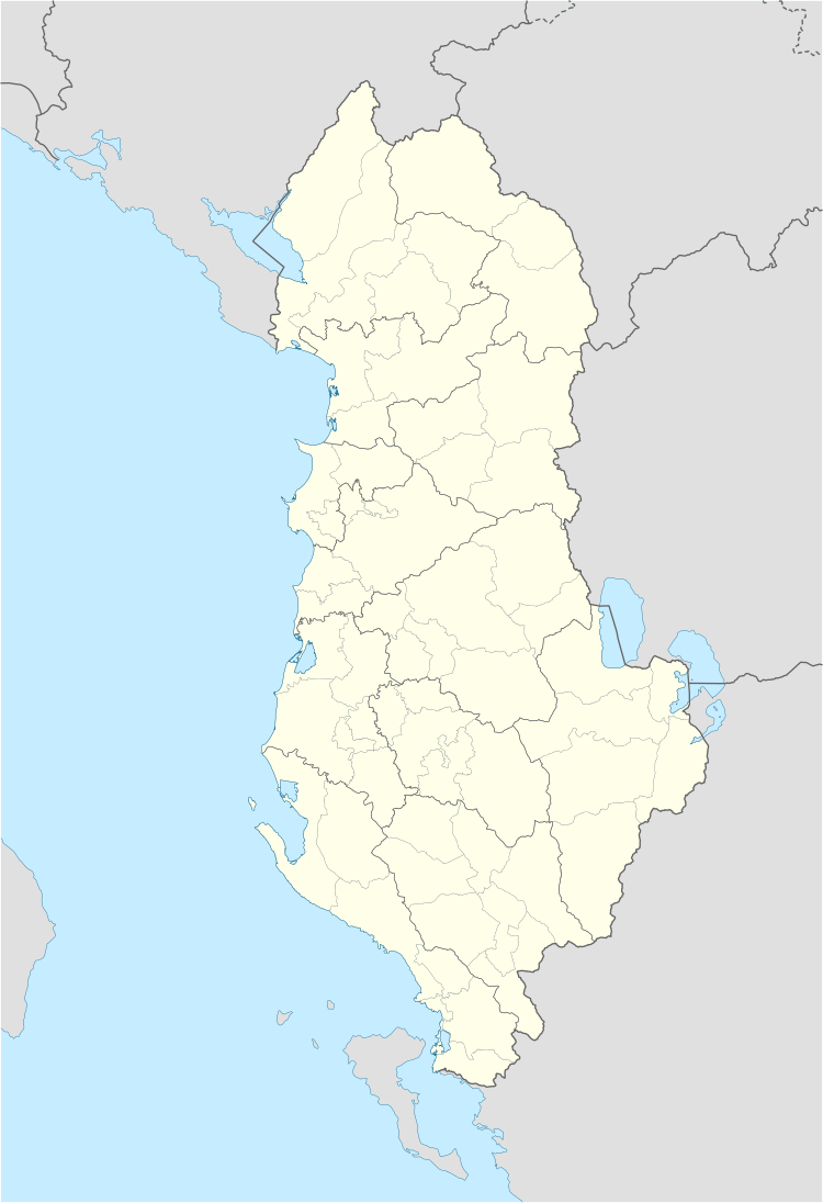
Map

[edit]
[edit]

Notes

[edit]
  1. ^ An 'Urban Audit City' is an area, where at least 50% of the city's population lives in an urban centre as well as where at least 75% of the urban centre's population lives in a city.[1]

References

[edit]
  1. ^ Jump up to: a b c d e "A new urban-rural classification of Albanian population" (PDF). Institute of Statistics (INSTAT). Archived (PDF) from the original on 21 November 2017. Retrieved 11 October 2020.
  2. ^ Dijkstra, Lewis; Poelman, Hugo. "Cities in Europe–The new OECD-EC definition" (PDF). Organisation for Economic Co-operation and Development (OECD). p. 13. Archived (PDF) from the original on 11 October 2020. Retrieved 11 October 2020.
  3. ^ Jump up to: a b c d Nurja, Ines. "Censusi i popullsisë dhe banesave/ Population and Housing Census–Kukës (2011)" (PDF). Tirana: Institute of Statistics (INSTAT). p. 39. Archived (PDF) from the original on 27 March 2020. Retrieved 11 October 2020.
  4. ^ Jump up to: a b c d e f Nurja, Ines. "Censusi i popullsisë dhe banesave/ Population and Housing Census–Fier (2011)" (PDF). Tirana: Institute of Statistics (INSTAT). p. 85. Archived (PDF) from the original on 8 October 2020. Retrieved 11 October 2020.
  5. ^ Jump up to: a b c d e Nurja, Ines. "Censusi i popullsisë dhe banesave/ Population and Housing Census–Berat (2011)" (PDF). Tirana: Institute of Statistics (INSTAT). p. 85. Archived (PDF) from the original on 9 October 2020. Retrieved 11 October 2020.
  6. ^ Jump up to: a b c d e f Nurja, Ines. "Censusi i popullsisë dhe banesave/ Population and Housing Census–Korçë (2011)" (PDF). Tirana: Institute of Statistics (INSTAT). p. 85. Archived (PDF) from the original on 27 March 2020. Retrieved 11 October 2020.
  7. ^ Jump up to: a b c d e f Nurja, Ines. "Censusi i popullsisë dhe banesave/ Population and Housing Census–Dibër (2011)" (PDF). Tirana: Institute of Statistics (INSTAT). p. 85. Archived (PDF) from the original on 27 March 2020. Retrieved 11 October 2020.
  8. ^ Jump up to: a b c d e Nurja, Ines. "Censusi i popullsisë dhe banesave/ Population and Housing Census–Elbasan (2011)" (PDF). Tirana: Institute of Statistics (INSTAT). p. 85. Archived (PDF) from the original on 27 March 2020. Retrieved 11 October 2020.
  9. ^ Jump up to: a b c d e f g h Nurja, Ines. "Censusi i popullsisë dhe banesave/ Population and Housing Census–Vlorë (2011)" (PDF). Tirana: Institute of Statistics (INSTAT). p. 85. Archived (PDF) from the original on 13 June 2020. Retrieved 11 October 2020.
  10. ^ Jump up to: a b c d e f Nurja, Ines. "Censusi i popullsisë dhe banesave/ Population and Housing Census–Durrës (2011)" (PDF). Tirana: Institute of Statistics (INSTAT). p. 85. Archived (PDF) from the original on 27 March 2020. Retrieved 11 October 2020.
  11. ^ Jump up to: a b c d e Nurja, Ines. "Censusi i popullsisë dhe banesave/ Population and Housing Census–Shkodër (2011)" (PDF). Tirana: Institute of Statistics (INSTAT). p. 85. Archived (PDF) from the original on 26 August 2020. Retrieved 11 October 2020.
  12. ^ Jump up to: a b c d e f g Nurja, Ines. "Censusi i popullsisë dhe banesave/ Population and Housing Census–Gjirokastër (2011)" (PDF). Tirana: Institute of Statistics (INSTAT). p. 85. Archived (PDF) from the original on 27 March 2020. Retrieved 11 October 2020.
  13. ^ Jump up to: a b c d e f Nurja, Ines. "Censusi i popullsisë dhe banesave/ Population and Housing Census–Tirana (2011)" (PDF). Tirana: Institute of Statistics (INSTAT). p. 85. Archived (PDF) from the original on 9 October 2020. Retrieved 11 October 2020.
  14. ^ Jump up to: a b c d e f g h i Nurja, Ines. "Censusi i popullsisë dhe banesave/ Population and Housing Census–Lezhë (2011)" (PDF). Tirana: Institute of Statistics (INSTAT). p. 85. Archived (PDF) from the original on 27 March 2020. Retrieved 11 October 2020.
Arc.Ask3.Ru: конец переведенного документа.
Arc.Ask3.Ru
Номер скриншота №: 27a15d9e6be7778ed21150da36a7afc6__1692278820
URL1:https://arc.ask3.ru/arc/aa/27/c6/27a15d9e6be7778ed21150da36a7afc6.html
Заголовок, (Title) документа по адресу, URL1:
List of cities and towns in Albania - Wikipedia
Данный printscreen веб страницы (снимок веб страницы, скриншот веб страницы), визуально-программная копия документа расположенного по адресу URL1 и сохраненная в файл, имеет: квалифицированную, усовершенствованную (подтверждены: метки времени, валидность сертификата), открепленную ЭЦП (приложена к данному файлу), что может быть использовано для подтверждения содержания и факта существования документа в этот момент времени. Права на данный скриншот принадлежат администрации Ask3.ru, использование в качестве доказательства только с письменного разрешения правообладателя скриншота. Администрация Ask3.ru не несет ответственности за информацию размещенную на данном скриншоте. Права на прочие зарегистрированные элементы любого права, изображенные на снимках принадлежат их владельцам. Качество перевода предоставляется как есть. Любые претензии, иски не могут быть предъявлены. Если вы не согласны с любым пунктом перечисленным выше, вы не можете использовать данный сайт и информация размещенную на нем (сайте/странице), немедленно покиньте данный сайт. В случае нарушения любого пункта перечисленного выше, штраф 55! (Пятьдесят пять факториал, Денежную единицу (имеющую самостоятельную стоимость) можете выбрать самостоятельно, выплаичвается товарами в течение 7 дней с момента нарушения.)