Фьорд

В физической географии , фьорд или фьорд ( / ˈ f j ɔːr d , f iː ɔː ɔːr d / [ 1 ] ) - это длинная узкая море , с крутые стороны или скалы, созданный ледником . [ 2 ] Фьорды существуют на побережьях Антарктиды , в Арктике и окружающих супругах северного и южного полушария. [ 3 ] Береговая линия Норвегии оценивается в длину 29 000 км (18 000 миль) с ее почти 1200 фьордами, но длиной всего лишь 2500 км (1600 миль), за исключением фьордов . [ 4 ] [ 5 ]
Формация
[ редактировать ]


Истинный фьорд образуется, когда ледник обрезает U-образную долину путем сегрегации льда и истирания окружающей коренной породы. [ 6 ] Согласно стандартной модели, ледники, образованные в предсвитанных долинах с мягким наклонным полом долины. Работа ледника затем оставила перегретую U-образную долину, которая внезапно заканчивается на долине или впадине. Такие долины являются фьордами, когда затоплены океаном. Пороги над уровнем моря создают пресноводные озера. [ 7 ] Ледяное таяние сопровождается восстановлением коры Земли, когда ледяная нагрузка и эродированный отложения удаляются (также называется изостазией или ледниковым отскоком). В некоторых случаях этот отскок быстрее, чем повышение уровня моря . Большинство фьордов глубже, чем прилегающее море ; Sognefjord , Норвегия , достигает до 1300 м (4265 футов) ниже уровня моря . У фьордов обычно есть подоконник или мелководье (коренная порода) во рту, вызванную сниженной скоростью эрозии предыдущего ледника и терминальной мореной . [ 8 ] Во многих случаях этот подоконник вызывает экстремальные токи и большие рапиды соленой воды (см. Skookumchuck ). Saltstraumen в мире в Норвегии часто описывается как самый сильный приливный ток . Эти характеристики отличают фьорды от RIAS (таких как залив Котор ), которые утонуты долин, затопленные восходящим морем. Drammensfjorden вырезан почти в двух от Svelvik «хребет», песчаной морены, которая находилась ниже уровня моря, когда он был покрыт льдом, но после того, как пост-личный отскок достиг 60 м (200 футов) над фьордом. [ 9 ]
В 19 -м веке Jens Esmark представила теорию о том, что фьорды созданы или были созданы ледниками и что большая часть северной Европы была покрыта густым льдом в предыстории. [ 10 ] Пороги у ртов и перерыва фьордов по сравнению с океаном являются самым убедительным доказательством ледникового происхождения, [ 11 ] И эти пороги в основном скалистые. Пороговые значения связаны со звуками и низкой землей, где может распространяться лед и, следовательно, обладать меньшей эрозивной силой. Джон Уолтер Грегори утверждал, что фьорды имеют тектоническое происхождение и что ледники играли незначительную роль в их формировании. Взгляды Грегори были отклонены последующими исследованиями и публикациями. В случае hardangerfjord переломы каледонской сгиба направляют эрозию ледниками, в то время как нет четкой связи между направлением Согнефьорда и шаблоном сгиба. [ 10 ] Эта связь между переломами и направлением фьордов также наблюдается в Лингене . [ 12 ] Прекрасные, третичные реки, по -видимому, разрушили поверхность и создали долины, которые впоследствии направляли ледниковый поток и эрозию коренной породы. В частности, это было в частности в западной Норвегии, где третичное подъем усилившихся эродирующих сил рек. [ 10 ]
Слияние притоков фьордов привело к раскопкам самых глубоких бассейнов фьордов. Рядом с самым побережье типичный западный норвежский ледник распространился (предположительно через звуки и низкие долины), потерял свою концентрацию и уменьшил силу ледников, чтобы разрушить, оставляя пороги коренной породы. Bolstadfjorden имеет 160 м (520 футов) глубиной с порогом всего 1,5 м (4 фута 11 дюймов), [ 10 ] [ 7 ] в то время как глубина 1300 м (4300 футов) глубиной согнефьорден имеет порог глубиной от 100 до 200 м (от 330 до 660 футов). [ 13 ] [ 14 ] Hardangerfjord состоит из нескольких бассейнов, разделенных порогами: самый глубокий бассейн Samlafjorden между Jonaneset ( Jondal ) и Ålvik с отчетливым порогом в Vikingneset в муниципалитете KVAM . [ 10 ]

Висящие долины распространены вдоль ледяных фьордов и U-образных долин . Висящая долина - это приточная долина, которая выше, чем в основной долине и была создана приточными ледниками потоками в ледник с большим объемом. Похоже, что долина мелкой, висит »над главной долиной или фьордом. Часто водопады образуются в или рядом с выходом верхней долины. [ 15 ] Небольшие водопады в этих фьордах также используются в качестве пресноводных ресурсов. Висящие долины также встречаются под водой в системах фьордов. Ветви Согнефьорда, например, намного меньше, чем основной фьорд. Устье Fjærlandsfjord имеет глубину около 400 м (1300 футов), в то время как главный фьорд составляет 1200 м (3900 футов) поблизости. Устье Икефьорда имеет глубину всего 50 м (160 футов), в то время как главный фьорд составляет около 1300 м (4300 футов) в той же точке. [ 11 ]
Особенности и вариации
[ редактировать ]
Гидрология
[ редактировать ]В течение зимнего сезона обычно есть небольшой приток пресной воды. Поверхностная вода и более глубокая вода (до 100 м или 330 футов или более) смешиваются зимой из -за постоянного охлаждения поверхности и ветра. В глубоких фьордах все еще есть пресная вода с лета с меньшей плотностью, чем более соленая вода вдоль побережья. Оффшорный ветер, распространенный в районах фьордов зимой, устанавливает ток на поверхности от внутренней до внешней части. Этот ток на поверхности, в свою очередь, тянет плотную соленую воду от побережья через порог фьорда и в самые глубокие части фьорда. [ 16 ] Bolstadfjorden имеет порог всего 1,5 м (4 фута 11 дюймов), а сильный приток пресной воды из реки Воссо создает солоноватую поверхность, которая блокирует циркуляцию глубокого фьорда. Более глубокие, солевые слои Болстадфьорда лишены кислорода, а морское дно покрыто органическим материалом. Неглубокий порог также создает сильный приливный ток. [ 7 ]
В течение летнего сезона во внутренних районах обычно существует большой приток речной воды. Эта пресная вода смешивается с соленой водой, создавая слой солоноватой воды с немного более высокой поверхностью, чем океан, который, в свою очередь, устанавливает ток из уст реки к океану. Этот ток постепенно более соленый в сторону побережья, и прямо под поверхностным током существует обратный ток более соленой воды от побережья. В более глубоких частях фьорда холодная вода, оставшаяся от зимы, все еще и отделена от атмосферы солоноватым верхним слоем. Эта глубокая вода вентилируется путем смешивания с верхним слоем, заставляя ее тепло и освещать в течение лета. [ 17 ] В фьордах с мелким порогом или низким уровнем смешивания этой глубокой воды не заменяется каждый год, а низкая концентрация кислорода делает глубокую воду непригодной для рыбы и животных. В наиболее крайних случаях на поверхности существует постоянный барьер пресной воды, и фьорд замерзает так, что под поверхностью нет кислорода. Drammensfjorden - один из примеров. [ 16 ] Смешивание в фьордах преимущественно возникает в результате распространения внутреннего прилива от подоконника входа или внутреннего сбора. [ 18 ]
Глуповая ветвь Согнефьорена в Gaupnefjorden сильно поражается пресной водой, так как ледяная река втечет. Векфьорден имеет небольшой приток пресной воды. [ 19 ]
Коралловые рифы
[ редактировать ]В 2000 году были обнаружены некоторые коралловые рифы вдоль нижней части норвежских фьордов. [ 20 ] Эти рифы были найдены в фьордах с севера Норвегии на юг. Считается, что морская жизнь на рифах является одной из самых важных причин, по которой норвежская береговая линия является такой щедрой рыболовной площадкой. Поскольку это открытие довольно новое, было проведено мало исследований. Рифы - это тысячи форм жизни, такие как планктон , кораллы , анемоны , рыба, несколько видов акулы и многие другие. Большинство специально адаптированы к жизни под большим давлением толщи воды над ним и полной темнотой глубокого моря. [ 21 ]
Фьорды Новой Зеландии также являются глубоководными кораллами , но поверхностный слой темной пресной воды позволяет эти кораллы расти в гораздо более мелкой воде, чем обычно. Подводная обсерватория в Милфорд -Саунд позволяет туристам просматривать их без погружения. [ 22 ]
Скирри
[ редактировать ]В некоторых местах рядом с краями районов с фьордами настолько многочисленные и разнообразные в направлении, что скалистое побережье разделено на тысячи островных блоков, некоторые большие и гористые, в то время как другие являются просто скалистыми точками или каменными рифами , угрожающая навигация. Они называются Skerries . [ 21 ] Термин «Скери» получен из старого норвежского скера , что означает камень в море. [ 23 ]
Скриры, наиболее часто образующиеся на выходе фьордов, где погруженные в ледниковые доли, перпендикулярные побережью, соединяются с другими перекрестными долинами в сложной массиве. Островная бахрома Норвегии - такая группа скерри (называется Skjærgård ); Многие из перекрестных фьордов настолько расположены, что они параллельны побережью и обеспечивают защищенный канал за почти непрерывной последовательности горных островов и скеров. По этому каналу можно пройти через охраняемый проход почти по всему маршруту 1601 км (995 миль) от Ставангера до Северного Кейпа , Норвегия. Blindleia Кристианса -это водный путь, защищенный скерри, который начинается недалеко от и на юге Норвегии и продолжает мимо лиллезанда . Шведское Бохуслана побережье вдоль также охраняется. обеспечивает Внутренний проход аналогичный маршрут из Сиэтла , штат Вашингтон и Ванкувера , Британская Колумбия , в Скагуэй , Аляска . Еще один такой защищенный скера, защищенный скрип, простирается от севера Магеллана в течение 800 км (500 миль).
Фитопланктон
[ редактировать ]Fjords provide unique environmental conditions for phytoplankton communities. In polar fjords, glacier and ice sheet outflow add cold, fresh meltwater along with transported sediment into the body of water. Nutrients provided by this outflow can significantly enhance phytoplankton growth. For example, in some fjords of the West Antarctic Peninsula (WAP), nutrient enrichment from meltwater drives diatom blooms, a highly productive group of phytoplankton that enable such fjords to be valuable feeding grounds for other species.[24] Вполне возможно, что по мере того, как изменение климата уменьшает долгосрочную производительность расплавленной воды, динамика питательных веществ в таких фьордах сдвигается, чтобы предположить менее продуктивные виды, дестабилизируя экологию пищевой сети систем FJORD.
In addition to nutrient flux, sediment carried by flowing glaciers can become suspended in the water column, increasing turbidity and reducing light penetration into greater depths of the fjord. This effect can limit the available light for photosynthesis in deeper areas of the water mass, reducing phytoplankton abundance beneath the surface.[25]
Overall, phytoplankton abundance and species composition within fjords is highly seasonal, varying as a result of seasonal light availability and water properties that depend on glacial melt and the formation of sea ice. The study of phytoplankton communities within fjords is an active area of research, supported by groups such as FjordPhyto, a citizen science initiative to study phytoplankton samples collected by local residents, tourists, and boaters of all backgrounds.
Epishelf lakes
[edit]An epishelf lake forms when meltwater is trapped behind a floating ice shelf and the freshwater floats on the denser saltwater below. Its surface may freeze forming an isolated ecosystem.

Etymology
[edit]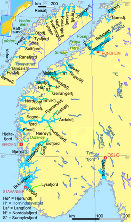
The word fjord is borrowed from Norwegian, where it is pronounced [ˈfjuːr], [ˈfjøːr], [ˈfjuːɽ] or [ˈfjøːɽ] in various dialects and has a more general meaning, referring in many cases to any long, narrow body of water, inlet or channel (for example, see Oslofjord).
The Norwegian word is inherited from Old Norse fjǫrðr, a noun which refers to a 'lake-like' body of water used for passage and ferrying and is closely related to the noun ferð "travelling, ferrying, journey".[26][27] Both words go back to Indo-European *pértus "crossing", from the root *per- "cross". The words fare and ferry are of the same origin.[28][29]
The Scandinavian fjord, Proto-Scandinavian *ferþuz, is the origin for similar Germanic words: Icelandic fjörður, Faroese fjørður, Swedish fjärd (for Baltic waterbodies), Scots firth (for marine waterbodies, mainly in Scotland and northern England).[27][29] The Norse noun fjǫrðr was adopted in German as Förde, used for the narrow long bays of Schleswig-Holstein, and in English as firth "fjord, river mouth". The English word ford (compare German Furt, Low German Ford or Vörde, in Dutch names voorde such as Vilvoorde, Ancient Greek πόρος, poros, and Latin portus) is assumed to originate from Germanic *ferþu- and Indo-European root *pertu- meaning "crossing point". Fjord/firth/Förde as well as ford/Furt/Vörde/voorde refer to a Germanic noun for a travel: North Germanic ferd or färd and of the verb to travel, Dutch varen, German fahren; English to fare.[30]
As a loanword from Norwegian,[26] it is one of the few words in the English language to start with the sequence fj.[31] The word was for a long time normally spelled fiord,[32] a spelling preserved in place names such as Grise Fiord. The fiord spelling mostly remains only in New Zealand English, as in the place name Fiordland.[33]
Scandinavian usage
[edit]

The use of the word fjord in Norwegian, Danish and Swedish is more general than in English and in international scientific terminology. In Scandinavia, fjord is used for a narrow inlet of the sea in Norway, Denmark and western Sweden, but this is not its only application. In Norway and Iceland, the usage is closest to the Old Norse, with fjord used for both a firth and for a long, narrow inlet. In eastern Norway, the term is also applied to long narrow freshwater lakes (Randsfjorden and Tyrifjorden) and sometimes even to rivers (for instance in Flå Municipality in Hallingdal, the Hallingdal river is referred to as fjorden). In southeast Sweden, the name fjard fjärd is a subdivision of the term 'fjord' used for bays, bights and narrow inlets on the Swedish Baltic Sea coast, and in most Swedish lakes. This latter term is also used for bodies of water off the coast of Finland where Finland Swedish is spoken. In Danish, the word may even apply to shallow lagoons. In modern Icelandic, fjörður is still used with the broader meaning of firth or inlet. In Faroese fjørður is used both about inlets and about broader sounds, whereas a narrower sound is called sund. In the Finnish language, a word vuono is used although there is only one fjord in Finland.
In old Norse genitive was fjarðar whereas dative was firði. The dative form has become common place names like Førde (for instance Førde), Fyrde or Førre (for instance Førre).[34]
The German use of the word Föhrde for long narrow bays on their Baltic Sea coastline, indicates a common Germanic origin of the word. The landscape consists mainly of moraine heaps. The Föhrden and some "fjords" on the east side of Jutland, Denmark are also of glacial origin. But while the glaciers digging "real" fjords moved from the mountains to the sea, in Denmark and Germany they were tongues of a huge glacier covering the basin of which is now the Baltic Sea. See Förden and East Jutland Fjorde.
Whereas fjord names mostly describe bays (though not always geological fjords), straits in the same regions typically are named Sund, in Scandinavian languages as well as in German. The word is related to "to sunder" in the meaning of "to separate". So the use of Sound to name fjords in North America and New Zealand differs from the European meaning of that word.
The name of Wexford in Ireland is originally derived from Veisafjǫrðr ("inlet of the mud flats") in Old Norse, as used by the Viking settlers—though the inlet at that place in modern terms is an estuary, not a fjord. Similarly the name of Milford (now Milford Haven) in Wales is derived from Melrfjǫrðr ("sandbank fjord/inlet"),[35] though the inlet on which it is located is actually a ria.
Before or in the early phase of Old Norse angr was another common noun for fjords and other inlets of the ocean. This word has survived only as a suffix in names of some Scandinavian fjords and has in same cases also been transferred to adjacent settlements or surrounding areas for instance Hardanger, Stavanger, and Geiranger.[36][37]
Differences in definitions
[edit]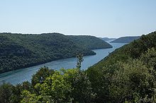
The differences in usage between the English and the Scandinavian languages have contributed to confusion in the use of the term fjord. Bodies of water that are clearly fjords in Scandinavian languages are not considered fjords in English; similarly bodies of water that would clearly not be fjords in the Scandinavian sense have been named or suggested to be fjords. Examples of this confused usage follow.
In the Danish language some inlets are called a fjord, but are, according to the English language definition, technically not a fjord. For example, Roskilde Fjord. Limfjord in English terminology is a sound, since it separates the North Jutlandic Island (Vendsyssel-Thy) from the rest of Jutland. However, the Limfjord once was a fjord until the sea broke through from the west. Ringkøbing Fjord on the western coast of Jutland is a lagoon. The long narrow fjords of Denmark's Baltic Sea coast like the German Förden were dug by ice moving from the sea upon land, while fjords in the geological sense were dug by ice moving from the mountains down to the sea. However, some definitions of a fjord is: "A long narrow inlet consisting of only one inlet created by glacial activity". Examples of Danish fjords are: Kolding Fjord, Vejle Fjord and Mariager Fjord.
The fjords in Finnmark in Norway, which are fjords in the Scandinavian sense of the term, are not universally considered to be fjords by the scientific community,[38] because although glacially formed, most Finnmark fjords lack the steep-sided valleys of the more southerly Norwegian fjords. The glacial pack was deep enough to cover even the high grounds when they were formed. The Oslofjord, on the other hand, is a rift valley, and not glacially formed.
The indigenous Māori people of New Zealand see a fjord as a kind of sea (Māori: tai) that runs by a bluff (matapari, altogether tai matapari "bluff sea").[39]
"Fjords" not created by glaciers
[edit]The term "fjord" is sometimes applied to steep-sided inlets which were not created by glaciers. Most such inlets are drowned river canyons or rias. Examples include:
- In Acapulco, Mexico, the calanques (narrow, rocky inlets) on the western side of the city, where the famous cliff-divers perform daily, are described in the city's tourist literature as being fjords.
- The calanques of Parc national des Calanques, Provence, France, are also referred to as fjords.[40]
- Camel Estuary at Padstow, Cornwall, England, is sometimes referred to as a fjord.[41][unreliable source?] despite being classified as a ria.
- The Fiordo di Furore in Italy is actually a ria.
- Golfo Dulce in Puntarenas, Costa Rica. Like the Saco de Mamangua below, it is sometimes described as a "tropical fjord".
- The Khor ash Sham in the Musandam Peninsula in Oman, and other "khors" or inlets in the deeply indented coast of Musandam, are often described as "fjords". They were formed by the subduction of the Arabian tectonic plate beneath the Eurasian plate.[42]
- Bay of Kotor in Montenegro
- the Lim bay in Istria, Croatia, is sometimes called "Lim fjord" although it is a ria dug by the river Pazinčica. The Croats call it Limski kanal, which does not translate precisely to the English equivalent either.
- Milford Haven Waterway in Pembrokeshire, Wales. This inlet is a ria. The place-name is derived from Old Norse Melrfjordr meaning "sandbank fjord".
- Port Davey in Tasmania, Australia is popularly believed to be a "fjord", but is now thought to be part of a drowned river valley system.[43]
- Saco De Mamangua in Rio de Janeiro, Brazil.[44] Colloquially, it's been labeled the world's "only tropical fjord".
Freshwater fjords
[edit]
Some Norwegian freshwater lakes that have formed in long glacially carved valleys with sill thresholds, ice front deltas or terminal moraines blocking the outlet follow the Norwegian naming convention; they are frequently named fjords. Ice front deltas developed when the ice front was relatively stable for long time during the melting of the ice shield. The resulting landform is an isthmus between the lake and the saltwater fjord, in Norwegian called "eid" as in placename Eidfjord or Nordfjordeid. The post-glacial rebound changed these deltas into terraces up to the level of the original sea level. In Eidfjord, Eio has dug through the original delta and left a 110 m (360 ft) terrace while lake is only 19 m (62 ft) above sea level.[45][46] Such deposits are valuable sources of high-quality building materials (sand and gravel) for houses and infrastructure.[47] Eidfjord village sits on the eid or isthmus between Eidfjordvatnet lake and Eidfjorden branch of Hardangerfjord.[48] Nordfjordeid is the isthmus with a village between Hornindalsvatnet lake and Nordfjord.[49][50] Such lakes are also denoted fjord valley lakes by geologists.[51]
One of Norway's largest is Tyrifjorden at 63 m (207 ft) above sea level and an average depth at 97 m (318 ft) most of the lake is under sea level. Norway's largest lake, Mjøsa, is also referred to as "the fjord" by locals.[46] Another example is the freshwater fjord Movatnet (Mo lake) that until 1743 was separated from Romarheimsfjorden by an isthmus and connected by a short river. During a flood in November 1743, the river bed eroded and sea water could flow into the lake at high tide. Eventually, Movatnet became a saltwater fjord and renamed Mofjorden (Mofjorden [no]).[52] Like fjords, freshwater lakes are often deep. For instance Hornindalsvatnet is at least 500 m (1,600 ft) deep and water takes an average of 16 years to flow through the lake.[53] Such lakes created by glacial action are also called fjord lakes or moraine-dammed lakes.[54]
Some of these lakes were salt after the ice age but later cut off from the ocean during the post-glacial rebound.[19] At the end of the ice age Eastern Norway was about 200 m (660 ft) lower (the marine limit). When the ice cap receded and allowed the ocean to fill valleys and lowlands, and lakes like Mjøsa and Tyrifjorden were part of the ocean while Drammen valley was a narrow fjord. At the time of the Vikings Drammensfjord was still four or five m (13 or 16 ft) higher than today and reached the town of Hokksund, while parts of what is now the city of Drammen was under water.[55] After the ice age the ocean was about 150 m (490 ft) at Notodden. The ocean stretched like a fjord through Heddalsvatnet all the way to Hjartdal. Post-glacial rebound eventually separated Heddalsvatnet from the ocean and turned it into a freshwater lake.[56][57] In neolithic times Heddalsvatnet was still a saltwater fjord connected to the ocean, and was cut off from the ocean around 1500 BC.[58]
Some freshwater fjords such as Slidrefjord are above the marine limit.
Like freshwater fjords, the continuation of fjords on land are in the same way denoted as fjord-valleys. For instance Flåmsdal (Flåm valley) and Måbødalen.[10][59][60]

Outside of Norway, the three western arms of New Zealand's Lake Te Anau are named North Fiord, Middle Fiord and South Fiord. Another freshwater "fjord" in a larger lake is Western Brook Pond, in Newfoundland's Gros Morne National Park; it is also often described as a fjord, but is actually a freshwater lake cut off from the sea, so is not a fjord in the English sense of the term. Locally they refer to it as a "landlocked fjord". Such lakes are sometimes called "fjord lakes". Okanagan Lake was the first North American lake to be so described, in 1962.[61] The bedrock there has been eroded up to 650 m (2,133 ft) below sea level, which is 2,000 m (6,562 ft) below the surrounding regional topography.[62] Fjord lakes are common on the inland lea of the Coast Mountains and Cascade Range; notable ones include Lake Chelan, Seton Lake, Chilko Lake, and Atlin Lake. Kootenay Lake, Slocan Lake and others in the basin of the Columbia River are also fjord-like in nature, and created by glaciation in the same way. Along the British Columbia Coast, a notable fjord-lake is Owikeno Lake, which is a freshwater extension of Rivers Inlet. Quesnel Lake, located in central British Columbia, is claimed to be the deepest fjord formed lake on Earth.
Great Lakes
[edit]A family of freshwater fjords are the embayments of the North American Great Lakes. Baie Fine is located on the northwestern coast of Georgian Bay of Lake Huron in Ontario, and Huron Bay is located on the southern shore of Lake Superior in Michigan.
Locations
[edit]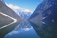


The principal mountainous regions where fjords have formed are in the higher middle latitudes and the high latitudes reaching to 80°N (Svalbard, Greenland), where, during the glacial period, many valley glaciers descended to the then-lower sea level. The fjords develop best in mountain ranges against which the prevailing westerly marine winds are orographically lifted over the mountainous regions, resulting in abundant snowfall to feed the glaciers. Hence coasts having the most pronounced fjords include the west coast of Norway, the west coast of North America from Puget Sound to Alaska, the southwest coast of New Zealand, and the west and to south-western coasts of South America, chiefly in Chile.
Principal fjord regions
[edit]- West coast of Europe
- Faroe Islands
- Westfjords of Iceland
- Eastern Region of Iceland
- West Highlands of Scotland
- Norway, the whole coast including Svalbard
- Kola Peninsula in Russia
- West coast of New Zealand
- Fiordland, in the southwest of the South Island
- Northwest coast of North America
- Coast of Alaska, United States: Lynn Canal, Glacier Bay, etc.
- British Columbia Coast, Canada: from the Alaskan Border along the Portland Canal to Indian Arm; Kingcome Inlet is a typical West Coast fjord.
- Hood Canal in Washington, United States and various of the arms of Puget Sound
- Northeast coast of North America
- Labrador: Saglek Fjord, Nachvak Fjord, Hebron Fjord
- The east coast of Ungava Bay.
- Baffin Island
- Ellesmere Island
- Greenland: Kangerlussuaq, Ilulissat Icefjord, Scoresby Sund, Disko Island
- Southwest coast of South America
- Fjords and channels of Chile
- Isla de los Estados, Argentina
Other glaciated or formerly glaciated regions
[edit]Other regions have fjords, but many of these are less pronounced due to more limited exposure to westerly winds and less pronounced relief. Areas include:
- Europe
- Ireland
- Russia (see also List of fjords of Russia)
- Scotland (where they are called firths, the Scots language cognate of fjord; lochs or sea lochs). Notable examples are:
- Loch Long
- Loch Fyne, Scotland's longest fjord at 65 km
- Loch Etive
- Sweden
- Gullmarsfjorden, in Bohuslän, Sweden
- Wales
- Mawddach Estuary,[63] a fjord in-filled by glacial deposits.
- North America
- Canada:
- the west and south coasts of Newfoundland, particularly:
- Facheux Bay
- Bonne Bay in Gros Morne National Park
- Aviron Bay
- La Hune Bay
- Bay de Vieux
- White Bear Bay
- Baie d'Espoir
- La Poile Bay
- Bay Le Moine
- the Canadian Arctic Archipelago
- Quebec, Saguenay Fjord[64]
- the west and south coasts of Newfoundland, particularly:
- United States:
- Somes Sound, Acadia National Park, Maine
- Hudson River
- most clearly seen at The Palisades
- Puget Sound
- Canada:
- South America
- Argentina:
- Arctic
- Antarctica
- South Georgia (UK)
- Kerguelen Islands (France)
- particularly the Antarctic Peninsula
- Sub-Antarctic islands

Extreme fjords
[edit]The longest fjords in the world are:
- Nansen Sound/Greely Fiord/Tanquary Fiord in Canada—420 km (261 mi) [65]
- Chatham Strait/Lynn Canal in United States—403 km (250 mi)[66]
- Scoresby Sund in Greenland—382 km (237 mi)[67][68]
- Concepción Channel-Puerto Simpson in Chile—245 km (152 mi)
- Sognefjord in Norway—204 km (127 mi)[69]
- Independence Fjord in Greenland—200 km (124 mi)
- Matochkin Shar, Novaya Zemlya, Russia—125 km (78 mi) (a strait with a fjord structure)[70]
Deep fjords include:
- Skelton Inlet in Antarctica—1,933 m (6,342 ft)
- Sognefjord in Norway—1,308 m (4,291 ft)[71][69] (the mountains then rise to up to 1,500 m (4,921 ft) and more, Hurrungane reaches 2,400 m (7,874 ft))[72]
- Messier Channel in Tortel, Chile—1,358 m (4,455 ft)[73][74]
- Baker Channel in Tortel, Chile—1,251 m (4,104 ft)
See also
[edit]References
[edit]- ^ "fjord". Merriam-Webster.com Dictionary. Merriam-Webster.
- ^ "What is a Fjord, and how is it formed". Norway Today. 2016-05-08. Archived from the original on 2017-12-25. Retrieved 2017-12-30.
- ^ Syvitsky, James P. M.; Burrell, David C.; Skei, Jens M. (1987). Fjords: Processes and Products. New York: Springer. pp. 46–49. ISBN 0-387-96342-1.
The NE coast, from Victoria Fjord to the Scoresby Sund fjord complex ..., has approximately 60 major fjords, some of them the world's largest and deepest. ... The SE coast, from Scoresby Sund to Kap Farvel ..., has approximately 100 fjords.
- ^ "Geografiske forhold (Geography of Norway)". Statistics Norway. Retrieved 24 March 2016.
- ^ Gregory, J. W. (1913). The Nature and Origin of Fiords. London: John Murray.
- ^ Murton, Julian B.; Peterson, Rorik; Ozouf, Jean-Claude (17 November 2006). "Bedrock Fracture by Ice Segregation in Cold Regions". Science. 314 (5802): 1127–1129. Bibcode:2006Sci...314.1127M. doi:10.1126/science.1132127. PMID 17110573. S2CID 37639112.
- ^ Jump up to: а беременный в Aarseth, I., Nesje, A. & Fredin, O. (2014). Западные норвежские фьорды. Геологическое общество Норвегии (NGF), Trondheim, 2014. ISBN 978-82-92-39491-5
- ^ Alley, RB; Де Доусон; GJ Larson; EB Evenson; GS Бейкер (14 августа 2003 г.). «Стабилизирующие отзывы в эрозии ледника». Природа . 424 (6950). Nature PublishingGroup: 758–760. Bibcode : 2003natur.424..758a . doi : 10.1038/nature01839 . PMID 12917679 . S2CID 4319448 .
- ^ Jørgensen, per: Четвертая геология . Сельскохозяйственный издатель, 1995.
- ^ Jump up to: а беременный в дюймовый и фон Holtedahl, H. (1967). «Заметки о формировании фьордов и фьорд-валли». Geografiska annaler. Серия А. Физическая география . 49 (2): 188–203.
- ^ Jump up to: а беременный Несье, Атл; Whillans, Ian M. (1 февраля 1994 г.). «Эрозия Согнефьорда, Норвегия» . Геоморфология . 9 (1): 33–45. Bibcode : 1994geomo ... 9 ... 33n . doi : 10.1016/0169-555x (94) 90029-9 . ISSN 0169-555X . Получено 20 сентября 2021 года .
- ^ Рэндалл, Бао (1961). Об отношениях направлений долины и фьордов к схеме перелома Лингена, Тромс Н. Норвегия. Geografiska annaler , 43 (3/4), 336–338.
- ^ Brøgger, Waldemar, ed. (1963). Географический лексикон . Осло: Каппелен.
- ^ «Согнефьорден» . snl.no. 15 августа 2021 года.
- ^ «Глоссарий терминологии ледника» . usgs.gov . Геологическая служба США. 28 мая 2004 г. Получено 2007-05-24 .
- ^ Jump up to: а беременный Skreslet, Stig (1980). Фьорды и прибрежный ручей . Åndalsnes; Раума/Ульвоа на весовой миске: Møre OG Romsdal Nature Conservation. С.
- ^ Симпсон, JH; Rippeth, TP (1993). «Клайд -море - модель сезонной стратификации и смешивания». Устье, прибрежная и шельфская наука (37): 129–144.
- ^ Arneborg, L., Janzen, C., Liljebladh, B., Rippeth, T., Simpson, JH & Stigebrandt, A. (2004). Пространственная изменчивость диапикнального смешивания и скорости турбулентного рассеяния в застойном бассейне фьорда. Журнал физической океанографии, 34 (7), 1679–1691 гг.
- ^ Jump up to: а беременный "Фьорд" . Норвежский информационный центр биоразнообразия. Архивировано с оригинала 3 февраля 2016 года . Получено 30 января 2016 года .
- ^ Институт морских исследований: коралловые рифы в Норвегии Архивировали 2008-10-11 на машине Wayback
- ^ Jump up to: а беременный "Фьорд" . National Geographic . Архивировано из оригинала 5 октября 2012 года . Получено 24 апреля 2015 года .
- ^ Пэдди Райан. Fiords - подводные камни и бассейны , Te Ara - Энциклопедия Новой Зеландии. Обновлено 21 сентября 2007 года. Доступ к 2008-04-18.
- ^ Мур 1890 , с. 277
- ^ Машиони, Мартина; Альмандос, Гастон О.; Экерн, Линдси; Пан, Б. Джек; Вернет, Мария (2021-12-01). «Микропланктонные диатомовые сборы доминировали в первичной продукции, но не в биомассе в антарктическом фьорде» . Журнал морских систем . 224 : 103624. Bibcode : 2021jms ... 22403624M . doi : 10.1016/j.jmarsys.2021.103624 . ISSN 0924-7963 .
- ^ Кан, Сунхо; Ким, да-донг; Кан, Чже-Шин; Yoo, Kyu-Cheul; Юн, Хо-Ил; Ли, Won-Cheol (2003). «Мониторинг морской среды и фитопланктона Kongsfjorden, Svalbard, Arctic» . Океан и полярное исследование . 25 (2): 213–226. doi : 10.4217/opr.2003.25.2.213 . ISSN 1598-141X .
- ^ Jump up to: а беременный Nesje, A. (2009). Фьорды Норвегии: сложное происхождение живописного ландшафта. В геоморфологических ландшафтах мира (стр. 223–234). Спрингер, Дордрехт.
- ^ Jump up to: а беременный в Лилль ух, Карианна (2021). "Фьорд" . Большой норвежский лексикон . Получено 11 декабря 2021 года .
- ^ Helleland, Botolv (1975). Норвежские имена мест/имена города . Осло: Грендаль. ISBN 8250401042 .
- ^ Jump up to: а беременный Мигон, П. (ред.). (2010). Геоморфологические ландшафты мира. Springer Science & Business Media, с. 223
- ^ Затем Капрона, Янн (2014). Норвежский этимологический словарь Кагге. ISBN 978-8-2489-1054-1 .
- ^ fjeld - еще один
- ^ Фаулер, HW (10 сентября 2009 г.) [1926]. Словарь современного английского использования: классическое первое издание: классическое первое издание . УП Оксфорд. п. 181. ISBN 978-0-19-953534-7 Полем
OED дает приоритет FI-. Другое правописание, по -видимому, используется на английском языке, чтобы помочь невежестве назвать его Fyord; Как, вместо того, чтобы помочь, это только озадачивает их, это должно быть заброшено
- ^ Райан, Пэдди (12 июня 2016 г.). "Форды " Те Ара - Энциклопедия Новой Зеландии 2022Марш
- ^ Rygh, O. (1898). Норвежские садовые названия: информация, собранная для использования в ревизии Matrix. Кристиания: Фабрития.
- ^ Морган, Ричард; Оуэн, Хайвел Вин (2022). Словарь местных названий Уэльса . Y lolfa. ISBN 9781800992399 Полем Получено 29 сентября 2023 года .
- ^ Rygh, O. (1896). Норвежское имя фьорда. Кристиания: Ашехуг.
- ^ Helle, Knut (1975). Ставангер: от Våg до города. Stavanger: Stabenfeldt. ISBN 8253201893 .
- ^ Bird, ECF (2008) Прибрежная геоморфология: введение , 2 -е изд. John Wiley and Sons Ltd. West Sussex, Англия. ISBN 978-0-470-51729-1
- ^ "Новая Зеландия географические особенности" . Новая Зеландия Географическая доска Новая Зеландия боксерские пурдоры . Земля Информация о Новой Зеландии.
- ^ «Калант: драгоценный камень на краю Марселя» . cotedazur.com . Прованс-Альпес-Кот-Д'Азур Туризм . Получено 7 мая 2024 года .
- ^ Фергюссон, Кирсти (2023). Корнуолл и острова Силли . Брэдт путеводителей. ISBN 9781804690987 .
- ^ «Трудные публикации, чтобы положить конец всем трудностям» . Би -би -си. 25 октября 2014 года.
- ^ Баркер, мы; Ахмад, Насир. «Пересмотр теории« фьорда »Порт-Дейви, Тасмания (1959)» (PDF) . Получено 29 сентября 2023 года - через Utas.edu.au.
- ^ Да Ф. Кляйн, Антонио Энрике; Шорт, Эндрю Д. (19 июля 2016 г.). Бразильские пляжные системы . Спрингер. п. 389. ISBN 9783319303949 Полем Получено 1 марта 2023 года .
- ^ География: ландшафт, ресурсы, человек, окружающая среда. Осло: Cappelen, 1999. ISBN 8202173078 .
- ^ Jump up to: а беременный Gustav Indrebø (1924): Норвежское озеро Название: округ Уппланд. Священные Писания (научная компания в Кристиании), исторический философский класс.
- ^ Рэмберг, IB (ред.). (2008). Создание земли: геология Норвегии . Геологическое общество Лондона.
- ^ Брекке, Нильс Георг; Скаар, Ронни Б. и Норд, Свейн (1993). Культурная историческая книга Hordaland. Nord4.
- ^ Твейт, Олав Якоб (1998). Внутренний Нордфьорд. Осло: Лунде. ISBN 8252031609 .
- ^ Indre Nordfjord: геология и ландшафт. Oppstryn: Jostedalsbreen National Park Center, 1995.
- ^ Bogen, J. (1983). Морфология и седиментология Дельт в озерах Фьорда и Фьорд -Вэлли. Осадочная геология, 36 (2–4), 245–267.
- ^ Bygdebok для Modalen и eksingedalen. Том 2. Sogenemnda, 1990.
- ^ Nve Атлас. Уотер-лак-база данных Depth Archived 2015-06-26 в The Wayback Machine (база данных National Lakes). Норвежское управление водных ресурсов и энергетики (Норвежские водные ресурсы и энергетическое управление). Доступ 13 июня 2015 года
- ^ Power, Kaare (1959). Мир озер . Осло: Universitetsforlaget.
- ^ Йохансен, Эйштейн Клок (1994). От ловца до викинга . Hokksund: Øvre Eiker Municipality.
- ^ Телемарк. Осло: Гилендал. 1975. ISBN 8205068445 .
- ^ Норвегия видела с воздуха . Осло: Лучший. 1980. ISBN 8270100935 .
- ^ Миккельсен, Эгил (1989). От охотника до фермера: развитие сельскохозяйственных сообществ в телемарке в каменном веке и бронзовом веке. Осло: старая коллекция университета. ISBN 8271810790 .
- ^ Hansen, L., Eilertsen, RS, Solberg, IL, Sveian, H. & Rokoengen, K. (2007). Характеристики фаций, морфология и осадочные модели глинистых отложений в долинах Терралов Фьорд, Норвегия. Осадочная геология, 202 (4), 710–729.
- ^ Lidmar-Bergström, K., Ollier, CD, & Sulebak, Jr (2000). Рельефные формы и история поднятия южной Норвегии. Глобальные и планетарные изменения, 24 (3), 211–231.
- ^ Насмит, Хью (1962). Поздняя ледниковая история и поверхностные месторождения Оканаганской долины, Британская Колумбия . Виктория, Британская Колумбия, Канада: Министерство энергетики, шахты и нефтяные ресурсы.
- ^ Эйлс, Николас; Маллинс, Генри Т.; Хайн, Альберт С. (1990). «Толстый и быстрый: седиментация в плейстоценовом озере Британской Колумбии, Канада». Геология . 18 (11): 1153–1157. Bibcode : 1990geo .... 18.1153e . doi : 10.1130/0091-7613 (1990) 018 <1153: Tafsia> 2.3.co; 2 .
- ^ Томас, Питер; Хоу, Джордж Мелвин (1968). Уэльские рельефы и пейзажи . Макмиллан.
- ^ «Река Сагэне» . Канадская энциклопедия . Архивировано из оригинала 22 августа 2012 года . Получено 8 декабря 2012 года .
- ^ Форд, Wm. L.; Хаттерсли-Смит, Г. (1965). На океанографии системы Nansen Sound Fiord . Арктический институт Северной Америки. п. 159
- ^ Мартин, Лоуренс; Уильямс, FE (1924). «Файорд с льдом: режим происхождения канала Линн, Аляска» . Географический обзор . 14 (4): 576–96. doi : 10.2307/208300 . JSTOR 208300 - через JSTOR.
- ^ Санделл, вор Туберг; Сэндлл, Биргер (1991). Археология и окружающая среда в результатах Sund Fjord Музей Tusculanum Press. П. 7. ISBN 87-635-1208-4 .
- ^ Мигонь, Петр , изд. (2010). Геоморфологические ландшафты мира . Спрингер. п. 227. ISBN 978-90-481-3054-2 .
- ^ Jump up to: а беременный Øi, Ørnulf (1987). Норвежский морской атлас: от шведской границы до Согнефьорда . Осло: Nautical Publishing Company в сотрудничестве с норвежским органом картирования, морской картой Норвегии. с. 225, 244. ISBN 8290335024 .
- ^ Александр П. Лизитцин, седиментация морского льда и айсберг в океане: недавнее и прошлое , с. 449.
- ^ Большой норвежский лексикон . «Согнефьорден» (на норвежском языке) . Получено 2010-09-04 .
- ^ Андерсен, Бьёрн Г. (2000). Ice Times в Норвегии. Пейзаж формируется ледниками . Осло: Universitetsforlaget . P. 9788200451341 .
- ^ «Самые глубокие фьорды в мире» . Worldatlas . 2018-11-26 . Получено 2022-05-26 .
- ^ Пирет, Лок; Бертран, Себастьен; Vandekerkhove, Elke; Харада, Наоми; Моффат, Карлос; Ривера, Андрес (2017-09-09). «Батиметрия в сетке комплекса фьорда Baker-Martinez (чили, 48 ° S) V1» . Система данных морской геологической науки . Figshare. doi : 10.6084/m9.figshare.5285521.v3 .
Библиография
[ редактировать ]- Мур, Артур Уильям (1890). Фамилии и места намыкают острова Человека . E. Stock. п. 2 ISBN 978-1110309573 Полем Получено 24 апреля 2015 года .
Фамилии и заполосные названия острова Мэн.

