List of cities and towns in Albania
(Redirected from List of towns in Albania)
| Administrative Divisions of Albania |
|---|
 |
This is a list of cities and towns in Albania categorised by municipality, county and population, according to the criteria used by the Institute of Statistics (INSTAT). As of 2014, there were 74 cities classified as urban areas and 2,972 villages as rural areas in Albania.[1] The legislation of Albania provides no official classification on the criteria of how to define a city or urban area.[1] Furthermore, according to the methodology for cities conducted by the Organisation for Economic Co-operation and Development (OECD), five areas, including Tirana, Durrës, Elbasan, Shkodër and Vlorë, can be classified as urban audit cities[a].[1][2]
Cities and towns in Albania belong to the following size ranges in terms of the number of population:
- One city larger than 250,000: Tirana
- Seven cities from 50,000 to 250,000: Durrës, Fier, Elbasan, Kamëz, Korçë, Shkodër and Vlorë
- Four cities from 20,000 to 50,000: Berat, Lushnjë, Pogradec and Kavajë
List
[edit]
Map
[edit]
Gallery
[edit]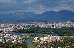


Notes
[edit]References
[edit]- ^ Jump up to: a b c d e "A new urban-rural classification of Albanian population" (PDF). Institute of Statistics (INSTAT). Archived (PDF) from the original on 21 November 2017. Retrieved 11 October 2020.
- ^ Dijkstra, Lewis; Poelman, Hugo. "Cities in Europe–The new OECD-EC definition" (PDF). Organisation for Economic Co-operation and Development (OECD). p. 13. Archived (PDF) from the original on 11 October 2020. Retrieved 11 October 2020.
- ^ Jump up to: a b c d Nurja, Ines. "Censusi i popullsisë dhe banesave/ Population and Housing Census–Kukës (2011)" (PDF). Tirana: Institute of Statistics (INSTAT). p. 39. Archived (PDF) from the original on 27 March 2020. Retrieved 11 October 2020.
- ^ Jump up to: a b c d e f Nurja, Ines. "Censusi i popullsisë dhe banesave/ Population and Housing Census–Fier (2011)" (PDF). Tirana: Institute of Statistics (INSTAT). p. 85. Archived (PDF) from the original on 8 October 2020. Retrieved 11 October 2020.
- ^ Jump up to: a b c d e Nurja, Ines. "Censusi i popullsisë dhe banesave/ Population and Housing Census–Berat (2011)" (PDF). Tirana: Institute of Statistics (INSTAT). p. 85. Archived (PDF) from the original on 9 October 2020. Retrieved 11 October 2020.
- ^ Jump up to: a b c d e f Nurja, Ines. "Censusi i popullsisë dhe banesave/ Population and Housing Census–Korçë (2011)" (PDF). Tirana: Institute of Statistics (INSTAT). p. 85. Archived (PDF) from the original on 27 March 2020. Retrieved 11 October 2020.
- ^ Jump up to: a b c d e f Nurja, Ines. "Censusi i popullsisë dhe banesave/ Population and Housing Census–Dibër (2011)" (PDF). Tirana: Institute of Statistics (INSTAT). p. 85. Archived (PDF) from the original on 27 March 2020. Retrieved 11 October 2020.
- ^ Jump up to: a b c d e Nurja, Ines. "Censusi i popullsisë dhe banesave/ Population and Housing Census–Elbasan (2011)" (PDF). Tirana: Institute of Statistics (INSTAT). p. 85. Archived (PDF) from the original on 27 March 2020. Retrieved 11 October 2020.
- ^ Jump up to: a b c d e f g h Nurja, Ines. "Censusi i popullsisë dhe banesave/ Population and Housing Census–Vlorë (2011)" (PDF). Tirana: Institute of Statistics (INSTAT). p. 85. Archived (PDF) from the original on 13 June 2020. Retrieved 11 October 2020.
- ^ Jump up to: a b c d e f Nurja, Ines. "Censusi i popullsisë dhe banesave/ Population and Housing Census–Durrës (2011)" (PDF). Tirana: Institute of Statistics (INSTAT). p. 85. Archived (PDF) from the original on 27 March 2020. Retrieved 11 October 2020.
- ^ Jump up to: a b c d e Nurja, Ines. "Censusi i popullsisë dhe banesave/ Population and Housing Census–Shkodër (2011)" (PDF). Tirana: Institute of Statistics (INSTAT). p. 85. Archived (PDF) from the original on 26 August 2020. Retrieved 11 October 2020.
- ^ Jump up to: a b c d e f g Nurja, Ines. "Censusi i popullsisë dhe banesave/ Population and Housing Census–Gjirokastër (2011)" (PDF). Tirana: Institute of Statistics (INSTAT). p. 85. Archived (PDF) from the original on 27 March 2020. Retrieved 11 October 2020.
- ^ Jump up to: a b c d e f Nurja, Ines. "Censusi i popullsisë dhe banesave/ Population and Housing Census–Tirana (2011)" (PDF). Tirana: Institute of Statistics (INSTAT). p. 85. Archived (PDF) from the original on 9 October 2020. Retrieved 11 October 2020.
- ^ Jump up to: a b c d e f g h i Nurja, Ines. "Censusi i popullsisë dhe banesave/ Population and Housing Census–Lezhë (2011)" (PDF). Tirana: Institute of Statistics (INSTAT). p. 85. Archived (PDF) from the original on 27 March 2020. Retrieved 11 October 2020.
