Дарбханга

Дарбханга
Дорбханга | |
|---|---|
Столичный
Город | |
     | |
| Nickname: Cultural Capital of Bihar | |
 Darbhanga Location in Bihar | |
| Coordinates: 26°10′N 85°54′E / 26.17°N 85.9°E | |
| Country | |
| State | Bihar |
| Region | Mithila |
| District | Darbhanga |
| Established | 01 January 1875 |
| Government | |
| • Type | Municipal Corporation |
| • Body | Darbhanga Municipal Corporation |
| • Mayor | Smt. Anjum Ara |
| • Municipal Commissioner | Shri Kumar Gaurav (IAS) |
| • SP City | Shri Sagar Kumar (IPS) |
| • Member of Parliament | Gopal Jee Thakur (BJP) |
| • MLA | Sanjay Saraogi (BJP) |
| Area | |
| • Total | 39.83 km2 (15.38 sq mi) |
| Elevation | 52 m (171 ft) |
| Population (2011) | |
| • Total | 296,039 |
| Demonym | Darbhangiya |
| Languages | |
| • Official | Hindi[2] |
| • Additional official | Urdu[3] |
| • Regional | Maithili |
| Time zone | UTC+5:30 (IST) |
| PIN | |
| Telephone code | 06272 |
| ISO 3166 code | IN-BR |
| Vehicle registration | BR-07 |
| Sex ratio | 1000:910 ♂/♀ |
| Lok Sabha constituency | Darbhanga |
| Vidhan Sabha constituency | Darbhanga, Darbhanga Rural, Bahadurpur, Keoti, Jale, Kusheshwar Asthan, Gaura Bauram, Benipur, Alinagar, Hayaghat |
| Website | darbhanga |


Дарбханга является пятой по величине городом и муниципальной корпорацией в штате Бихар в Индии и считается важным городом в Северном Бихаре . Он служит штаб -квартирой района Дарбханга и дивизии Дарбханги . Считается, что название Дарбханга было получено от Двар Банга или Дари - Банга , что означает «дверь Бенгалии ». [ 6 ]
Дарбханга была местом бывшей династии Хандвала Замидаар под Моголами и Британской Индией . Он считается важным медицинским центром Северного Бихара, так как он находится в Медицинском колледже и больнице Дарбханга , и второй AIIMS Бихар, то есть AIIMS DARBHANGA, должен быть построен здесь. [ 7 ] [ 8 ] [ 9 ] [ 10 ]
Дарбханга - один из старейших городов в Индии. Музыкальные, народные и литературные традиции на санскрите, урду , хинди и Майтили передали поколения в Дарбханге и составляют сильный культурный фон города. Он широко известен как «культурная столица Бихара» и «Сердце Митиланчала ». [ 11 ]
History
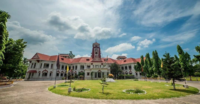
[edit]The city was the capital of the Darbhanga Raj, an estate established in the 16th century, containing the Anandbagh Palace. It was constituted as a municipality in 1864. Darbhanga is home to the Kameshwara Singh Darbhanga Sanskrit University (established 1961), which is located on the grounds of the palace, and the Lalit Narayan Mithila University (established 1972). Darbhanga has a museum housing archaeological materials, as well as historical and handicrafts exhibits.
Darbhanga has been a centre for music since the late 18th century and has produced multiple well-known dhrupad (an ancient form of Indian classical music) musicians. A major rail and road junction, Darbhanga trades in agricultural produce, mangoes, and fish. In addition to food processing, the city has a light manufacturing industry.
Darbhanga is situated on a vast alluvial plain, with low-lying areas containing marshes and lakes. Grains, oilseeds, tobacco, sugarcane, and mangoes are important crops in the region.[12]
Under the British Raj, Darbhanga was a part of Sarkar Tirhut until 1875, when it was constituted into a separate district. Its subdivisions had been constituted earlier – Darbhanga Sadar in 1845, Madhubani in 1866, and Samastipur (then known as Tajpur) in 1867. The city of Darbhanga is said to have been founded by one Darbhangi Khan, about whom practically nothing is known. It is also held that the name Darbhanga is derived from Dwar Banga or Dar-e-Banga, meaning the 'door of Bengal'. This etymology does not appear to be accurate as the division between Bengal and Bihar has always been held to be further to the east. Nonetheless, the region has a linguistic and cultural affinity with Bengal.[13]
Excavation at Balirajgarh revealed brick fortifications dating back to the 2nd century BC.[14]
Geography
[edit]Darbhanga is located in the northern part of Bihar. It lies between 25.53 degrees - 26.27 degrees N and 85.45 degrees - 86.25 degrees E at an average elevation of 171 feet (52 m). Darbhanga district covers an area of 2,279 sq km. Darbhanga is bounded by Madhubani district in the north, Samastipur district in the south, Saharsa district in the east, and Sitamarhi district and Muzaffarpur district in the west. Being located in Mithilanchal, Darbhanga district has a vast fertile alluvial plain devoid of any hills. It has a gentle slope from north to south direction having a depression in the centre. Darbhanga experiences a humid subtropical climate. It experiences three main seasons which are winter, summer, and rainy seasons. May is the hottest month when the temperature reaches up to 43 °C. Darbhanga district receives an average of 1142.3 mm rainfall and almost 92% of the annual rainfall is received during monsoon.
Places adjacent to Darbhanga |
|---|
Climate
[edit]Darbhanga has a humid subtropical climate (Köppen climate classification Cwa).
| Climate data for Darbhanga (1971–1990, extremes 1901–1998) | |||||||||||||
|---|---|---|---|---|---|---|---|---|---|---|---|---|---|
| Month | Jan | Feb | Mar | Apr | May | Jun | Jul | Aug | Sep | Oct | Nov | Dec | Year |
| Record high °C (°F) | 30.6 (87.1) |
34.1 (93.4) |
40.6 (105.1) |
43.9 (111.0) |
44.1 (111.4) |
43.6 (110.5) |
39.3 (102.7) |
38.6 (101.5) |
38.6 (101.5) |
39.4 (102.9) |
34.1 (93.4) |
36.6 (97.9) |
44.1 (111.4) |
| Mean daily maximum °C (°F) | 23.1 (73.6) |
25.8 (78.4) |
31.0 (87.8) |
35.1 (95.2) |
35.0 (95.0) |
34.9 (94.8) |
32.5 (90.5) |
32.8 (91.0) |
32.5 (90.5) |
31.6 (88.9) |
29.0 (84.2) |
24.8 (76.6) |
30.7 (87.3) |
| Daily mean °C (°F) | 16.2 (61.2) |
18.4 (65.1) |
23.0 (73.4) |
27.1 (80.8) |
28.2 (82.8) |
28.8 (83.8) |
28.2 (82.8) |
28.4 (83.1) |
28.2 (82.8) |
26.5 (79.7) |
22.4 (72.3) |
17.7 (63.9) |
24.4 (75.9) |
| Mean daily minimum °C (°F) | 9.2 (48.6) |
11.0 (51.8) |
15.1 (59.2) |
19.4 (66.9) |
21.2 (70.2) |
22.9 (73.2) |
23.8 (74.8) |
24.2 (75.6) |
23.8 (74.8) |
21.2 (70.2) |
15.8 (60.4) |
10.6 (51.1) |
18.2 (64.8) |
| Record low °C (°F) | 0.0 (32.0) |
0.0 (32.0) |
4.1 (39.4) |
9.4 (48.9) |
10.6 (51.1) |
11.0 (51.8) |
13.5 (56.3) |
15.5 (59.9) |
13.5 (56.3) |
10.0 (50.0) |
7.2 (45.0) |
2.6 (36.7) |
0.0 (32.0) |
| Average precipitation mm (inches) | 13 (0.5) |
14 (0.6) |
9 (0.4) |
29 (1.1) |
76 (3.0) |
139 (5.5) |
353 (13.9) |
254 (10.0) |
193 (7.6) |
73 (2.9) |
6 (0.2) |
7 (0.3) |
1,166 (45.9) |
| Average rainy days (≥ 1.0 mm) | 1.6 | 1.7 | 1.6 | 2.6 | 4.6 | 7.6 | 16.4 | 12.2 | 10.5 | 3.4 | 0.5 | 1.0 | 63.7 |
| Average relative humidity (%) | 68 | 63 | 49 | 56 | 60 | 70 | 78 | 79 | 79 | 73 | 66 | 67 | 67 |
| Source 1: NOAA (1971–1990)[15] | |||||||||||||
| Source 2: India Meteorological Department[16] | |||||||||||||
Demographics
[edit]The 2011 Census of India recorded Darbhanga as an Urban agglomeration with a population of 296,039 while the surrounding district has 3 million people.[18] It is the 5th largest city in Bihar in terms of the urban population.[19] The city has 196,573 males (52.6%) and 183,552 females (47.4%). Darbhanga has an average literacy rate of 79.40%, with male literacy at 85.08% and female literacy at 73.08%.[20] However, as per the document published on 6 March 2021 by the office of District Magistrate Darbhanga, the urban population of Darbhanga stands 380,125.[19]
At the time of the 2011 census, 50.25% of the population spoke Maithili, 26.80% Urdu and 20.98% Hindi as their first language.[21]
Transport
[edit]Railways
[edit]

Darbhanga Junction lies on the East Central Railway. It is connected directly to all the major cities of India. Laheriasarai Railway Station is the second major station of Darbhanga and works as an important railway station for people living in south Darbhanga.
There are daily and weekly trains available for New Delhi, Patna, Secunderabad, Kolkata, Varanasi, Ahmedabad, Lokmanya Tilak Terminus, Howrah, Amritsar, Pune and other major cities.
Darbhanga Airport
[edit]


Darbhanga also has its own commercial airport which is connected with all the major cities of India.
Darbhanga Airport (IATA: DBR, ICAO: VE89) is a civil enclave at the Darbhanga Air Force Station of the Indian Air Force, 6 kilometres from Darbhanga City near the ![]() NH 527B and
NH 527B and ![]() NH 27 East-West Corridor Expressway which passes through Darbhanga. The civil enclave is operated by the Airports Authority of India (AAI). The foundation stone for the project was laid by Chief Minister Nitish Kumar and then Civil Aviation Minister Suresh Prabhu in the presence of state Civil Aviation Minister Jayant Sinha on 24 December 2018. After efforts taken by the MP of Darbhanga, Gopal Jee Thakur,[22][23] and the then Civil Aviation Minister, Hardeep Singh Puri. Commercial flights started on 8 November 2020.[24]
NH 27 East-West Corridor Expressway which passes through Darbhanga. The civil enclave is operated by the Airports Authority of India (AAI). The foundation stone for the project was laid by Chief Minister Nitish Kumar and then Civil Aviation Minister Suresh Prabhu in the presence of state Civil Aviation Minister Jayant Sinha on 24 December 2018. After efforts taken by the MP of Darbhanga, Gopal Jee Thakur,[22][23] and the then Civil Aviation Minister, Hardeep Singh Puri. Commercial flights started on 8 November 2020.[24]
Roadways
[edit]![]() NH 27 which is part of India's East–West highway corridor passes through Darbhanga.
Darbhanga is connected to other parts of India by
NH 27 which is part of India's East–West highway corridor passes through Darbhanga.
Darbhanga is connected to other parts of India by ![]() NH 27,
NH 27,![]() NH 527B and Bihar State highways 50, 56, 88 and 75. Darbhanga is also connected to Muzaffarpur, Samastipur, Madhubani and Sitamarhi.
NH 527B and Bihar State highways 50, 56, 88 and 75. Darbhanga is also connected to Muzaffarpur, Samastipur, Madhubani and Sitamarhi.
The East-West Corridor expressway, which connects Porbandar in Gujarat to Silchar in Assam, passes through Darbhanga.
The Amas–Darbhanga Expressway![]() NH 119D is an approved 4/6-lane wide access-controlled expressway in India. Once completed, it will be the first expressway in the state of Bihar.
NH 119D is an approved 4/6-lane wide access-controlled expressway in India. Once completed, it will be the first expressway in the state of Bihar. ![]() NH 119D connects Amas village in Gaya district to Bela Nawada village in Darbhanga district.
NH 119D connects Amas village in Gaya district to Bela Nawada village in Darbhanga district.
Education
[edit]Notable educational institutions include:
Medical colleges
[edit]
- All India Institutes of Medical Sciences (AIIMS) Darbhanga (Under Construction )
- Darbhanga Medical College and Hospital
- Mithila Minority Dental College and Hospital
University
[edit]- Indira Gandhi National Open University (IGNOU) Regional Centre
- Kameshwar Singh Darbhanga Sanskrit University
- Lalit Narayan Mithila University
- Maulana Azad National Urdu University
Engineering and technology colleges
[edit]- Darbhanga College of Engineering
- Women's Institute of Technology
- Government Polytechnic, Darbhanga
- Software Technology Park(STPI), Darbhanga
Colleges
[edit]Schools
[edit]- Darbhanga Public School
- Jesus & Mary Academy
- Madonna English School
- Rose Public School
- Don Bosco School, Darbhanga
Tourism
[edit]Darbhanga has various tourist attractions and is among the oldest cities of Bihar.
Tourist spots include:


- Chandradhari Museum
- Darbhanga Fort
- Maharajadhiraja Lakshmishwar Singh Museum
- Darbhanga Planetarium
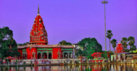
- Shyama Mai Temple
- Nargona Palace
- Anand Bagh Palace
- Raj Darbhanga
- Ahalya Sthan
- Kusheshwar Asthan
Media and communications
[edit]All India Radio has a 20 kW medium-wave radio station in Darbhanga which transmits various programmes of mass interest and covers a part of North Bihar as well as the Terai of Nepal.[citation needed]
Doordarshan has one DD National and one DD News LPT relay transmitters.[citation needed]
Notable people
[edit]- Kameshwar Singh, Maharaja
- Lakshmeshwar Singh Maharaja
- Rameshwar Singh Maharaja
- Sanjay Mishra, Bollywood actor
- Gopal Jee Thakur, BJP leader and Current Member of Parliament from Darbhanga.[25]
- Veena Devi, politician and member of the 17th Lok Sabha
- Abdul Bari Siddiqui, MLA
- Badri Narain Sinha, IPS
- Bhawana Kanth, first female fighter pilot of India
- Binodanand Jha, former MP
- Gangesha Upadhyaya, mathematician and philosopher
- Gonu Jha Pratyutpannamati
- Dr. Ashok Kr. Yadav, MP from Madhubani Lok Sabha constituency
- Gul Mohammad Khan, Bangladeshi musician
- H. C. Verma, physicist
- Hukmdev Narayan Yadav, former MP
- Imtiaz Ali (director), Bollywood director
- Kirti Azad, former MP and cricketer
- M J Warsi, linguist
- Nagarjun, poet, writer, essayist, and novelist
- Narayan Das, politician
- Nigamananda Saraswati, Hindu monk
- Prabhat Jha (politician), politician
- Parmanand Jha, first vice president of Nepal
- Ram Chatur Mallick, musician
- Ramnandan Mishra, Indian nationalist who fought for India's freedom from British rule
- Sultan Ahmad, former MLA
- Sanjay Saraogi, MLA
- Dr. Murari Mohan Jha, MLA from Keoti Vidhan Sabha Assembly Constituency
- Satya Narayan Sinha, politician
- Surendra Jha 'Suman', poet, freedom fighter, politician, essayist, literary critic, journalist, publisher and academician
- Jyoti Kumari, Sirhulli, cyclist and Bal Puraskar recipient 2021[26]
- Tariq-ur-Rehman, cricketer
- Tochi Raina, singer, composer, and philosopher
- Yamuna Karjee, Indian independence activist
- Betty von Fürer-Haimendorf, ethnologist
- Ritviz, electronic singer
- Manas Bihari Verma, Padam Shri decorated Aeronautical scientist, LCA Tejas[27]
- Ram Gopal Bajaj, Indian actor and academic
- Ishtiaque Ahmad Qasmi Indian Islamic scholar, mufti and writer
- Aishwarya Sushmita, model and actress
See also
[edit]References
[edit]- ^ "Darbhanga City".
- ^ "52nd Report of the Commissioner for Linguistic Minorities in India" (PDF). nclm.nic.in. Ministry of Minority Affairs. Archived from the original (PDF) on 25 May 2017. Retrieved 22 January 2019.
- ^ "NCLM52ndReport" (PDF). 25 May 2017. Archived from the original (PDF) on 25 May 2017.
- ^ "STD & PIN Codes". Retrieved 23 January 2020.
- ^ "Pin Codes of Darbhanga, Bihar, India, Darbhanga Pincode Search". indiapincodes.net.
- ^ "Welcome to Darbhanga District | Official Website of Darbhanga District | India". Retrieved 18 May 2023.
- ^ "'Best site chosen for AIIMS at Darbhanga'". The Times of India. 15 March 2023.
- ^ "संसद में गोपाल जी ठाकुर ने उठाई दरभंगा में एम्स की मांग". Dainik Jagran (in Hindi). Retrieved 31 March 2023.
- ^ "एम्स का मुद्दा संसद में उठाए जाने पर सांसद को दी गई बधाई".
- ^ "संसद में फिर गूंजा दरभंगा एम्स निर्माण का मुद्दा सांसद ने कहासरकार बदलने से फंसा है पेंच". ETV Bharat News (in Hindi). Retrieved 31 March 2023.
- ^ Culture. "Darbhanga: The Heart of Mithilaanchal!". Darbhanga.nic.in. Retrieved 30 December 2020.
- ^ "Darbhanga | India". Encyclopedia Britannica. Retrieved 17 June 2021.
- ^ "History | Welcome to Darbhanga District | India". Retrieved 17 June 2021.
- ^ A., Ghosh (1965). Indian Archaeology:A Review. New Delhi: Archaeological Survey of India. pp. 3–5.
- ^ "Darbhanga Climate Normals 1971–1990". National Oceanic and Atmospheric Administration. Archived from the original on 23 December 2012. Retrieved 18 August 2020.
- ^ "Extremes of Temperature & Rainfall for Indian Stations (Up to 2012)" (PDF). India Meteorological Department. December 2016. p. M33. Archived from the original (PDF) on 5 February 2020. Retrieved 18 August 2020.
- ^ «Таблица C-01 Население по религии: Бихар» . censususindia.gov.in . Генеральный регистратор и комиссар по переписи Индии . 2011 год
- ^ 2011-2022 | .
- ^ Jump up to: а беременный "2021030687.pdf" (PDF) .
- ^ «Перепись Индии: просмотреть детали населения» . www.censusindia.gov.in . Правительство Индии. 2001. Архивировано с оригинала 27 апреля 2016 года . Получено 14 января 2016 года .
- ^ Jump up to: а беременный «Таблица C-16 Население от родного языка: Бихар (город)» . censususindia.gov.in . Генеральный регистратор и комиссар по переписи Индии . 2011 год
- ^ Шарма, Субхаш (5 сентября 2020 г.). «Самолет скоро вылетит из аэропорта Дарбханга, депутат Гопал Джи Тхакур беседовает с чиновниками» . www.abplive.com (на хинди) . Получено 30 сентября 2023 года .
- ^ «Депутат Гопал Джи Тхакур сказал, что авиационная служба начнется для жителей Матилы 8 крор с 8 ноября - депутат Гопал Джи Тхакур сказал, что воздушная служба начнется 8 крор Матилава из Novimber 8» . Джагран (на хинди) . Получено 30 сентября 2023 года .
- ^ «Хорошие новости для Mithilanchal! Аэропорт Дарбханга начинает работать, см. Фотографии внутри» . Прабхат Хабар - Новости хинди (на хинди). 8 ноября 2020 года . Получено 8 ноября 2020 года .
- ^ «Участники: Лок Сабха» . loksabha.nic.in . Получено 1 марта 2023 года .
- ^ Джа, Бинай Куар (26 января 2021 г.). "Награда за циклу девушки " The Times of India 2021Марш
- ^ «Близкий помощник ученого бывшего президента Калама Манас Верма умирает» . Индус . 4 мая 2021 года.
Внешние ссылки
[ редактировать ] Определения из Wiktionary
  СМИ из Commons
  Новости от Wikinews
  Цитаты из Wikiquote
  Тексты из Wikisource
  Учебники из Wikibooks
  Ресурсы из Wikiversity
  Информация о путешествиях от Wikivoyage