Caddo Mounds Государственный исторический сайт

 Вход в Государственный исторический сайт Caddo Mound (до торнадо 2019 года) | |
 Caddo Mounds Государственный исторический сайт | |
| Location | Weeping Mary, Texas |
|---|---|
| Coordinates | 31°35′47″N 95°8′55″W / 31.59639°N 95.14861°W |
| Area | 353 acres (143 ha)[a] |
| History | |
| Founded | 780 CE |
| Abandoned | 1260 CE |
| Cultures | Caddoan Mississippian culture |
| Site notes | |
| Excavation dates | 1919, 1933, 1960s–1980s |
| Archaeologists | James Edwin Pearce, E. B. Sayles, H. Perry Newell |
| Management | Texas Historical Commission |
George C. Davis Site | |
| NRHP reference No. | 70000742[1] (original) 79003449[1] (increase) |
| Significant dates | |
| Added to NRHP | October 15, 1970 |
| Boundary increase | November 15, 1979 |
| Designated TSHS | 1974 |
| |

Государственный исторический сайт Caddo Mounds (41CE19) (также известный как сайт Джорджа С. Дэвиса ) является археологическим местом в плач Марии , штат Техас , США. Этот участок культуры в Миссисиппии Caddoan состоит из деревни и церемониального центра, в котором есть две насыпи для земляной платформы и один насыпь захоронения . Расположенный на тропе коренных американцев предварительного актакта, позже названной испанским языком El Camino Real de Los Tejas , поселение развивалось за сотни лет до прибытия европейцев в регион. Археологи считают, что участок был создан примерно в 800 г. н.э., причем большинство крупных строительства состоялось между 1100 и 1300 г. н.э.
Участок Caddo Mounds расположен в Восточном Техасе, в 6 милях (9,7 км) к западу от Альто на шоссе штата Техас 21 около его пересечения с США по маршруту 69 в районе Пайнси Вудс . Управляемый Техасской исторической комиссией , музей на этом месте был вновь открыт в октябре 2015 года. Новый музей дает посетителям возможность исследовать реплику Caddo Village, и все экспонаты практические. Посетители могут пройтись по самостоятельному интерпретирующему следу в 0,7 милях (1,1 км), чтобы увидеть захоронение Каддо, низкий храм и церемониальные курганы. Также доступна дополнительная тропа вдоль El Camino Real.
Description
[edit]
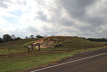
The site began with the founding of a permanent village by the Hasinai,[2] who moved into the region from the Red River area to the northeast, in roughly 850 to 900 CE.[3] The region had ideal qualities for a village: good soil, abundant food resources, and a permanent water source that flowed into the Neches River.[4] What eventually became the largest mound, Mound A, was begun at this time. It is at the southern edge of the site and was surrounded by about 40 houses. In 1100 a new mound was begun near the center of the site, Mound B, and would eventually measure roughly 175 feet (53 meters) north-south and 115 feet (35 meters) east-west. Mound C, the northernmost mound of the three, was used as a burial mound, not for elite residences or temples like the other two.[5] The site was the southwesternmost ceremonial mound center of all the great mound building cultures of North America.[5]
The settlement was abandoned when the local Caddo ritually capped the mounds around 1250 CE and focused their activities from the east to west, according to their oral history.[6] The outlying hamlets became more self-sufficient and grew less dependent on the site for religious and political matters. The Caddo culture that remained was similar to the earlier culture in many ways but was more egalitarian and did not import as many exotic goods.[4]
By the time Europeans arrived in the area in the 18th century, the Caddo groups in the area lived in small villages and hamlets, spread across the local landscape, and which had more autonomous, local governmance.[3]
The Hasinai groups continued to live in the Neches and Angelina River valleys up to the 1830s, but by the early 1840s, all Caddo groups had moved to the Brazos River area in an effort to avoid Anglo-American colonization. In 1855 the U.S. government moved them to the Brazos Indian Reservation. In 1859 it forced them to move again, to the Washita River in Indian Territory (now western Oklahoma).[4] The Caddo still primarily live in western Oklahoma, and Binger, Oklahoma is the capital of the federally recognized Caddo Nation of Oklahoma.
Modern excavations
[edit]The earliest recorded written mention of the mounds was in 1779 by Athanase de Mézières, who traveled from Louisiana to San Antonio in the employ of the Spanish government. In 1919 American James Edwin Pearce was the first professional archeologist to record the site for the Bureau of Ethnology (Smithsonian Institution). In 1933 archeologist E. B. Sayles concluded that the site was a Caddo mound center, after conducting surface collection of artifacts at the location.[3]
The first scientific excavations were conducted from 1939 to 1941 by H. Perry Newell, a University of Texas archeologist with the federal Work Projects Administration in the government of President Franklin D. Roosevelt. When Newell died, archeologist Alex D. Krieger took over investigations at the site and concluded that it had been a major Caddo site. Further excavations in the 1960s and early 1970s by Dee Ann Story pinpointed the timeline of the site to 780 and 1260.[3]
After acquiring seventy acres of the site, the Texas Parks and Wildlife Department established a historic park in 1974. It funded a series of excavations in the 1970s and 1980s. As a result of these excavations by the University of Texas at Austin, Texas A&M University, and private contractor Elton R. Prewitt, another twenty-three acres of land was added to the park in 1981. An interpretive visitors center was constructed at the site.[3] In 2008, the 80th Texas Legislature transferred operational control of the property to the Texas Historical Commission.[7]
The museum and members of the Caddo Nation of Oklahoma have collaborated on activities that help the public understand Caddo culture. In July 2016, elder Phil Cross was interviewed about construction of a Caddo grass house at the site, with workers using traditional techniques.[8]
2019 Tornado
[edit]On April 13, 2019, during celebrations of Caddo Culture Day, an EF3 tornado struck the Mounds, killing one person and injuring 30 to 40, including 8 who were critically injured. Patients were transported to the hospital on a school bus or were life flighted.[9] The mounds' visitor center and service buildings were heavily damaged, with a capital loss estimated at $2.5 million. The loss of the visitor center's museum-like display space destroyed many replica items, but actual artifacts had been withdrawn from public view long before by agreement between the Historical Commission and persons with standing in representation of the Caddo Confederacy of Native Americans.[10]
See also
[edit]- Battle Mound Site
- Spiro Mounds
- Caddo Nation of Oklahoma
- List of museums in East Texas
- List of Mississippian sites
- List of Texas State Historic Sites
- National Register of Historic Places listings in Texas
References
[edit]- ^ Jump up to: a b "National Register Information System". National Register of Historic Places. National Park Service. November 2, 2013.
- ^ "Caddo Mounds-Texas Historical Commission". Retrieved 2010-02-05.
- ^ Jump up to: a b c d e "Handbook of Texas Online-Caddoan Mounds State Historic Site". Retrieved 2010-02-05.
- ^ Jump up to: a b c "Brief History-Texas Historical Commission". Retrieved 2010-02-05.
- ^ Jump up to: a b "Caddo Mounds-Sites-Texas Native Skies". Archived from the original on 2015-04-23. Retrieved 2010-02-05.
- ^ Clark, Blue (2020). Indian Tribes of Oklahoma: A Guide (2nd ed.). Norman, OK: University of Oklahoma Press. p. 45. ISBN 9780806167619.
- ^ "Caddoan Mounds State Historic Site-Operated by the Texas Historical Commission". Retrieved 2010-02-05.
- ^ "Caddo Grass House Build", Longview News-Journal, 03 July 2016; accessed 07 November 2017
- ^ McBride, Jessica (13 April 2019). "Caddo Mounds Tornado: Texas Historic Site Struck". Heavy.com. Retrieved 14 April 2019.
- ^ Frazier, Stephanie (16 April 2019). "Estimated cost to rebuild Caddo Mounds State Historic site $2.5 million". KLTV. Retrieved 21 April 2019.
External links
[edit]- Caddo Mounds State Historic Site website
- The Encyclopedia of Arkansas History and Culture (The Caddo Indians)
- The Encyclopedia of Arkansas History and Culture (Indian Mounds)
- A History of the Caddo Indians
