Сент -Хеленс, Мерсисайд

| Сент -Хеленс | |
|---|---|
| Город | |
| |
 St Helens Location within Merseyside | |
| Population | 137,332 (2021 Census) |
| OS grid reference | SJ505955 |
| • London | 174 mi (280 km)[1] SE |
| Metropolitan borough | |
| Metropolitan county | |
| Region | |
| Country | England |
| Sovereign state | United Kingdom |
| Districts of the town | List |
| Post town | ST. HELENS |
| Postcode district | WA9, WA10, WA11 |
| Dialling code | 01744 |
| Police | Merseyside |
| Fire | Merseyside |
| Ambulance | North West |
| UK Parliament | |


Сент -Хеленс ( ) является городом в Мерсисайде , Англия, с населением 102 629. Это административный центр столичного района Сент -Хеленс население 183 200 , в переписи 2021 года . [ 2 ] [ 3 ] [ 4 ] [ 5 ]
The town is 6 miles (10 kilometres) north of the River Mersey, in the south-west part of historic Lancashire. The town was initially a small settlement within the historic county's ancient hundred of West Derby in the township of Windle but by the mid-1700s the town had developed into a larger urban area beyond the townships borders. By 1838 the council was formally made responsible for the administration of Windle and the three other townships of Eccleston, Parr and Sutton that were to form the town's traditional shape. In 1868 the town was incorporated as a municipal borough, then later became a county borough in 1887. In 1974 the town was made a metropolitan borough within the new Metropolitan County of Merseyside by the Local Government Act 1972, with an expanded administrative responsibility for several nearby towns and villages.[6][7]
The town was famous for its heavy industry, particularly its role in the coal mining industry, glassmaking, chemicals and copper smelting and sail making that drove its growth throughout the Industrial Revolution. Originally home to a large number of industrial employers such as Beechams, the Gamble Alkali Works, Ravenhead Glass, United Glass Bottles (UGB), Triplex, Daglish Foundry, Greenall's brewery, the glass producer Pilkington is the town's only remaining large industrial employer.[8][9][19]
The town is today most famous for its Rugby League team St Helens R.F.C. who have won 3 World Club Challenge cups in recent years, and museums such as the North West Museum of Road Transport, the World of Glass and art installations such as Dream.
History
[edit]Pre-history
[edit]The southern part of what became the traditional county of Lancashire was at least partially settled by the Brigantes, a Celtic tribe, who were subjugated by the Romans during their 1st Century conquest, with nearby Wigan suggested as a location for the Roman settlement of Coccium.[20][21] Eccleston in St Helens appears to derive its name from either the Latin ecclesia or the Brittonic eglwys, both meaning "church", suggesting a common link to a place of worship although none is known in that township until the 19th century.[22]
The first recorded settlements are the Manors, Parishes and Titled Lands listed in the Domesday Book in the 11th century. The titled lands would have encompassed the modern townships of Sutton, Windle and Parr as part of their fiefdoms, though it may be inferred from the listed tithes that the land was populated before then.[23][24][25]
Formation
[edit]


St Helens did not exist as a town in its own right until as late as the middle of the 18th century when it is referenced in Parliament.[26][27] The development of the town has a complex history: it was spurred on by the rapid population growth in the region during the Industrial Revolution. Between 1629 and 1839, St Helens grew from a small collection of houses surrounding an old chapel,[28] to a village,[24][29] before becoming the significant urban centre of the four primary manors and surrounding townships that make up the modern town.[2][29][30][31][26]
The Domesday Book of 1086 reveals that several manors existed at that time, although there are no specific references to "St Elyn", or mentions of the particular "vill" or villages. Windle is first recorded on some maps as "Windhull" (or variations thereof) in 1201,[24] Bold in 1212 (as Bolde)[32] and Parr (or Parre) in 1246,[25] whilst Sutton[23] and Ecclestone[22] composed part of the Widnes "fee" (a hereditary entitlement of ownership) under a Knight or Earl.[23] It is known that the Hospitallers held lands in the area of Hardshaw as early as 1292, known as Crossgate[23][24] (which may be referred to by the long built-over Cross Street in the town centre beneath the modern College campus) and many of the original parishes, townships and local areas are named after the families that owned the land between the 11th and 18th centuries.[23][31]
The Ecclestone family owned the Eccleston township.[31] Their ancestral home dates to 1100; it was built by Hugh Ecclestone. The family is referred to throughout the period until the 18th century when they departed for nearby Southport.[33]
The manor of Parr remained in control of the Parr family and their descendants from the 13th to the early 15th century when a distant relative of the original family line, William Parr, 1st Marquess of Northampton (brother of Henry VIII's wife Catherine Parr) sold the manor to the Byroms of Lowton.[31] The family later supported the Royalists during the English Civil War, and Henry Byrom (son of the Lord of the Manor) died at the Battle of Edgehill.[34]
The extensive lands of Sutton Manor stretched across the open and flat land leading towards the Mersey. The manor's name is of unknown origin, but the land within the estate referred to several leading families, including Eltonhead, Ravenhead, and Sherdley.[31] In 1212, William de Daresbury was the title holder of the manors.[23] The Sherdley family can be traced back to the Northales, who had been settled in the area since at least 1276 when they were referred to as plaintiffs in a boundary dispute with the Lords of Rainhill.[23]
Windle contained the smaller Hardshaw, described as a berewick[31] in the Domesday Book. It was in Hardshaw that Chapel Lane was constructed. The Windle Family were Lords of the Manor and Township from the Norman period onward before ceding control to the Gerards of Bryn.[31]
"This tiny hamlet [in] Hardshaw including the chapel-of-ease, from which its name was taken, became the nucleus of the town."
— Mike Fletcher, Black Gold & Hot Sand, 2002[31]
In 1139, the earldom of Derby, in the Peerage of England, was created: Norman descendant Robert De Ferrers was the first Earl. Subsequently, the region passed to John of Gaunt, and eventually the Stanley family. Their ancestral home was eventually established in the nearby Knowsley area (to the west of the modern St Helens borough), with the foundation of a hunting lodge in the 15th century and subsequently Knowsley Hall in the 18th century. The Earl of Derby's lands encompassed a region from Liverpool to Manchester, and to the north beyond Lancaster and were primarily turned to meeting the pastoral needs of the people.[23][24]
Throughout this period, the area was predominantly arable land[10][24] and was noted for its large swathes of moss, heath and bog land while elsewhere in parts, it was covered by the greater Mersey Forest[10] (the larger "Community Forest" was not established until much later).[35]
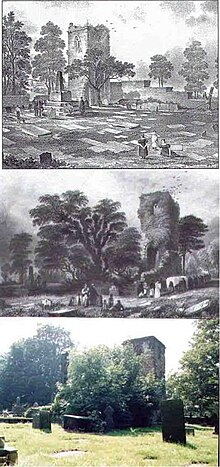
The origin of the name "St Helens" stretches back at least to a chapel of ease dedicated to St Elyn,[24][36] the earliest documented reference to which is in 1552.[10][24] The first time the chapel was formally referred to appears to be 1558, when Thomas Parr of Parr bequeathed a sum of money "to a stock towards finding a priest at St. Helen's Chapel in Hardshaw, and to the maintenance of God's divine service there for ever, if the stock go forward and that the priest do service as is aforesaid".[24] Early maps show that it was originally in Chapel Lane, near the site of the modern pedestrianised Church Street. Historically this would have fallen within the berewick of Hardshaw, within the greater township of Windle (making up the southern border)[29][31] abutting onto the open farmland of Parr to the east, and Sutton and Eccleston to the south and west respectively.
In 1552, the Chapel of St Elyn was noted as "consisting only of a challis and a lytle bell".[10] The chapel was described as being at the crux of the four townships of Eccleston, Parr, Sutton and Windle,[10] and lay on the intersecting roads that criss-crossed the area and linked Lancashire towns such as Liverpool, Ormskirk, Lathom[10] and the Cheshire region south of the River Mersey.[24] The transport link is attested to by the existence of Chester Lane (the modern B5419 is much foreshortened) that originally wound through the west of the town heading south to the Mersey crossing point of Warrington[24] and beyond to the ancient Chester Road (that now makes up part of the modern A56) that stretched between the historic town of its name and the Manchester townships.[24] The chapel also sat directly between the port town of Liverpool, and the landlocked Manchester townships that would become important in the development of the greater area of both St Helens and Wigan.[10]
As a busy thoroughfare it is suggested by historian and genealogist William Farrer that a village existed in the vicinity for centuries,[24] later sharing the name of the chapel. It is known from the diaries of a local Puritan by the name of Adam Martindale[28] that by the time the King's Head Inn was constructed in 1629 on "the great road" (taken to refer to all or part of Chester Lane) between Warrington and Ormskirk, a number of houses, farms and manors counted amongst the properties in the local vicinity and general area.[24] Martindale notes that by 1618 that the original chapel had been demolished and rebuilt[28] in the same vicinity. In 1678 a building was converted for use as a meeting place for the Society of Friends by George Shaw of Bickerstaffe. Local historians believe the building had been used for another purpose long before 1678. The Quaker Friends' Meeting House, as it is now known, is a Grade II listed building.
The strong link to Roman Catholicism in the area was maintained throughout this period by the eventual Lords of Sutton Manor, the De Holland family, starting in 1321.[23] Thomas Holland, a local Jesuit priest, was arrested and tried for high treason in October 1642 as "taking orders by authority of the see of Rome and returning to England". The first step toward his beatification was allowed by Pope Leo XIII in 1886.[23] Conversely Roger Holland was burnt at the stake for heresy when he continued his professed belief in the Reformed churches some 100 years earlier in 1558 during the persecution of Mary I.[23] It is suggested that Ravenhead Hall was the site of a Catholic chapel during the most severe of Catholic persecutions during the 17th and 18th centuries.[23] Whilst the Lathom family maintained Rainfords close connections, as did the Ecclestons.[22][23]
Less well-known is the Windle connection to witches. In 1602, two women were sent to Lancaster for trial, while a decade later Isobel Roby was submitted to Sir Thomas Gerard, accused of upsetting the ship upon which James VI and I's Queen Consort Anne of Denmark was arriving. Roby was finally executed at Lancaster, along with the Pendle and Salmesburg witches, on 20 August 1612.
By 1746, St Helens, composed of the greater area of the four townships (and their collieries) beyond Prescot, was referred to in a statement in Parliament related to the extension of the Liverpool to Prescot Turnpike.[26]
The rapid growth of St Helens at the centre of the townships is attested to by several authors. The Penny Cyclopaedia states in 1839 that "Saint Helen's, Lancashire, is in the township of Windle, in the chapelry of St Helen's, Prescott parish. The township contains 3,540 acres (1,430 hectares), and had in 1831 a population of 5,825. The town has risen into importance of late years"[29] In contrast by 1844 (30 years before the borough of St Helens was established) Cyrus Redding mentions a reversal of the roles: "St Helens, originally an inconsiderable village, is now a very thriving town"; and he later states that the town "... may be said to contain the four townships of Sutton, Parr, Windle and Eccleston".[37] The composition of the town described by Redding largely mirrors those observations made by Samuel Lewis in 1848[2] and later still in 1874 by John Marius Wilson[30] and John Bartholemew in 1887.[38]
Census figures from 1801 suggest the population of the District Area of St Helens to be 12,500;[39] by 1861 it was between 37,631 and 55,523[39] (John Marius Wilson gives the lower number, with total households at the specific figure of 6,539) in the wider area[30] with St Helens itself comprising a population of 20,176 in 3,577 households.[30] The Ordnance Survey map of 1843 shows St Helens as the significant urban centre[40]
The original Town Hall was constructed in 1839 and described by Wilson in 1874 as "in the Italian style, with a Corinthian portico; and contains a lock-up, a newsroom, and a large hall for courts, concerts, balls, and public meetings".[30] It was not until 1852 that the Civil Parish of St Helens was instituted (noted in 1874 by Wilson as "more extensive than the town"[30]). The Mill Street Barracks were completed in 1861.[41]
On 2 February 1868, Queen Victoria granted a Charter of Incorporation, defining St Helens officially as a Municipal Borough. The first election of Councillors took place on 9 May the same year, followed by the first Town Council meeting on 18 May.[30] About 20 years later in 1887 St Helens became a County Borough, with two Members of Parliament.[38]
In 1894, the Parish of St Helens was incorporated under the 1893 St Helens Corporation Act.[3][42] This was achieved by the abolition of the Civil Parishes of Parr, Sutton and amalgamation of their townships. The Civil Parishes of Eccleston and Windle both ceded portions of their areas over to St Helens.[3]
The modern Borough of St Helens includes areas historically not associated with the town. The 1974 creation of the Ceremonial County of Merseyside appended the former urban districts of Haydock, Newton-le-Willows and Rainford, and parts of Billinge-and-Winstanley and Ashton-in-Makerfield urban districts, along with part of Whiston Rural District, all from the administrative county of Lancashire. The urban sprawl of St Helens was already extended up to the boundary lines of places such as Haydock and Rainhill, where inhabitants may consider themselves either part of either both St Helens the 'Town' or 'Borough', or just the Borough.
Industrial development
[edit]
Until the mid-18th century, the local industry was almost entirely based on small-scale home-based initiatives such as linen weaving.[10] The landscape was dotted with similarly small-scale excavation and mining operations, primarily for clay and peat, but also notably for coal. It is the coal to which the town owes both its initial growth and development[10] and the subsequent development of the coal-dependent industries of copper smelting and glass.
Sitting on the South Lancashire Coalfield, the town was built both physically and metaphorically on coal; the original motto in the borough council's coat of arms was "Ex Terra Lucem" ("From the Ground, Light")[43][44][45][46] and local collieries employed up to 5,000 men as late as the 1970s. During the boom years of the British coal industry (1913 was the peak year of production, with 1 million employed in UK mining industry) the St Helens division of the Lancashire and Cheshire Miners' Federation (the local miners' union) had the largest membership (10%) of that federation.[10]
The discovery of winnable coal seams is mentioned in 1556, referred to as "Beds of cinders or coke ... have been discovered three feet thick"[23] during the digging of a clay pit[31] and is commonly attributed to the Eltonhead family (Elton Head Road, the modern B5204, shares the name of the family) whilst reference to the significant distribution of "potsherds"[23] during excavation suggests that some light industry had been underway for some time before (perhaps as far back as the 13th century) and the clay and pottery industries lasted in the area through to the early 20th century.[22][23] A dispute arose between the landlord Bolds and the tenant Eltonheads, eventually resulting in an agreement to compensate the Bold family.[23][31]
The majority of the land had been turned over to arable farming since at least the 12th century, according to the historical family records of William De Daresbury. The township of Sutton was recorded as "by itself being assessed at four plough-lands".[23] Plow or ploughlands are assessed at 120 acres (49 hectares) apiece.[47] The pastoral use of the local land was common even in 1901, with William Farrer noting of Eccleston that the "country is of an undulating nature and principally dedicated to agriculture, fields of rich and fertile soil being predominant"[22] and describing the produce as "chiefly potatoes, oats, and wheat on a clayey soil which alternates with peat".[22] Even so, Farrer also notes that several old quarries and shafts still existed within the area while also making reference to a "brewery at Portico, and a pottery near Prescot, while glass, watchmakers' tools, and mineral waters are also manufactured".[22]
Two hundred years earlier, Farrer may well have seen a different sight: St Helens was scarred and pitted by shallow mining operations, often quickly abandoned, left to flood and exceedingly prone to collapse. The primitive mining techniques, and limited ability to bail out gathering water, meant many pits had short lifespans. Complaints are recorded in Sutton Heath in particular about the plans to expand mining across the town, but the lure of a stable income ultimately won out against the objections.[31] 100 years later, the Council rejected a planning application for an open cast mine — underlining the finality of the decline of coal mining in the area.[48]
In the 18th century, however, coal was an enabling force for the town that opened up opportunities for further commercial and industrial developments,[14] which in turn drove demand for the rapid movement of raw goods not simply out of the town (coal to Liverpool to fuel its shipping and steel works for instance, but also its salt works[31]) but also in promoting an influx of raw products for processing. The dependence of St Helens on its transport links is evident from claims made to Parliament in 1746 for maintenance and extension of the turnpike road after local flooding had damaged it.[31][26]
"because Prescot, being Three Miles nearer to Liverpoole than St Helens, Persons will naturally go to the former Place for Coals, if they can be supplied as well and as cheap there as at the latter"
— T.C. Barker quoting Witness John Eyes, Merseyside Town in the Industrial Revolution: St. Helens, 1750–1900[26]
It is clear that St Helens' development owes as much to its location on the south Lancashire Coalfield as it does the fact that Liverpool, Chester and other centres of industry were not, and yearned for the fossil fuel of choice.[31]
It was essential therefore for the town to maintain, and invest further in, transport links and promote itself as a hub for the growth of Liverpool, with its provision of raw materials benefiting from its location and promising transport links. Liverpool, recognising the need for a ready supply of coal for its forges, responded with a petition for the extension of the Liverpool to Prescot Turnpike.[26] This soon developed into a far more forward thinking development which was at the heart of the Industrial Revolution: canals.
It was originally proposed merely to make the Sankey Brook navigable, but the eventual outcome was a complete man-made canal linking St Helens to the River Mersey and the city of Liverpool. The Sankey Canal was opened in 1757, and extended in 1775, to transport coal from the pits in Ravenhead, Haydock and Parr to Liverpool, and for raw materials to be shipped to St Helens.
The transport revolution centred on the region encouraged an influx of industry to the hitherto sparsely populated area. With industry came job opportunities and population growth. Between 1700 St Helens grew from a sparsely populated array of manor houses and their tenants into a sprawling span of mining operations.[22][26]
Owing primarily to the abundance of coal reserves, the quality of local sand, and the availability of salt in nearby Cheshire,[10] glass making is known to have been ongoing in the Sutton area since at least 1688, when the Frenchman John Leaf Snr is recorded as paying the Eltonhead family £50 for a lease of 2½ acres (1 hectare) of Sutton's Lower Hey. The glass industry got a significant lift with the Crown-authorised "British Cast Plate Glass Company" established in Ravenhead in 1786;[12][13] it latched onto the success of similar enterprises to set the region as the market leader for glass.
The foundation of the companies owed as much to industrial leaders from outside the town (and the finance they provided) as to its natural resources but the synchronous development of the steam engine was a significant development, with James Watt's stationary steam engine design leading the way. Water could be pumped from deeper than ever before, and mines could be driven to find even more dense seams.[31] At the same time, the growth in use of machinery (e.g. for mills, forges, and ships) rapidly increased the demand for coal - to which the town responded.[31]
Land exchanged hands in St Helens rapidly, as established families moved out of the growing towns filled with the working classes to more gentrified and less industrially developed places. In their place came self-made wealthy industrialists such as John Mackay (who first leased land in St Helens in the 1760s from King George III before buying the land constituting Ravenhead Farm from the Archbishop of York), Michael Hughes, the Gambles, and later Thomas Beecham, Thomas Greenall and the Pilkingtons.[15][31] A few established families remained, such as the Gerards of Windle Hall. They made their land available for industrial use.[31]
"if any ... good colliers ... will apply at Thatto Heath Colliery, they will meet with constant employ and the best encouragement."
— Mike Fletcher quoting John Mackay, Black Gold & Hot Sand, 200[31]
One of the first major industries to grow out of the transport innovations in the region was copper smelting.[15] The Parys mining company, led by Michael Hughes, leased land from John Mackay close to the newly constructed Sankey Canal at Ravenhead (where Ravenhead Colliery had since been established).[31][26] This allowed copper ore carried from the Parys Mountain mine in Amlwch in Anglesey, North Wales to arrive in the St Helens region via the Mersey directly at the point where coal was being excavated to fire the forges of industry. Some 10,000 tons of copper ore yielding over 1,300 tons of copper passed along this route.[15][16] At the same time the Gerards were renting out land in Blackbrook to Patten & Co. from nearby Warrington.[49] The company smelted using the Gerards 'own coal, then moved the coal downstream from a private wharf on the navigable brook.[31][49]
The boom did not last: by 1783, coal industry leaders such as Mackay, Sarah Clayton and Thomas Case were all dead, penniless or both as a global constriction on coal shipments stifled the industry. An over-reliance on shipping to the USA during the American War of Independence (1775–1783) ruined many people, and led to the permanent loss of several smaller industries.[31] It took partnership and coordination with other industries for the mining industry to recover; with the US embargo lifted, the town's troubles were soon overcome if not forgotten, although this was not the last troubling incident.[31]
The demand for chemicals such as alkali from the glass industry soon led the Gamble family to start their lime and alkali pits, saving on import costs. The growing demand for chemical processing also contributed heavily to the growth of Widnes.
The Liverpool and Manchester Railway opened in 1830. It passed through the southern edge of the town at Rainhill and St Helens Junction, and furthered its economic development as a centre of industry.[10]
The decline of the mining industry
[edit]The last coal mine located close to the town centre (Ravenhead Colliery) and those located in the outlying districts of St Helens, including those that were just outside the original 1887 County Borough boundary, such as Clock Face (Clock Face Colliery), Sutton (Bold Colliery), Sutton Heath (Lea Green Colliery), Sutton Manor (Sutton Manor Colliery) and Haydock (Lyme Pit, Wood Pit, Old Boston), were all closed between the nationalisation of the deep coal mining industry in 1947 and 24 May 1991, when Sutton Manor Colliery, the last to go in the immediate St Helens area, finally closed its gates.[50]
The coal mining industry in St Helens and elsewhere had collapsed because the government maintained that the deep mining of coal was no longer an economically viable proposition in most British coalfields. The closures were opposed by the National Union of Mineworkers during the year-long Miners' Strike of 1984–85. After the collapse of the miners' strike in March 1985, St Helens was just one of dozens of towns in the UK that was immediately set to lose a long-standing employer. In the case of both Sutton Manor and Bold Collieries, it was estimated by some that when they were closed they each still had up to 40 years of winnable coal reserves.[51][52] The last colliery in the modern metropolitan borough, and in the St Helens area of the South Lancashire Coalfield, was Parkside, in Newton-le-Willows, which was closed in 1993.
Economy
[edit]The glass industry is no longer the major employer it once was; however, it still employs over a thousand people in the town.[53] The large Pilkington Brothers works, founded in 1826, dominates the town's industrial quarter and still produces all the UK's output of flat glass.[54]
In 1994, planning permission was sought out for a link road connecting the M62 directly with the town centre.[55] The development included a £5m retail and commercial property project in the Ravenhead area that had seen successive business closures with the folding of UGB and Ravenhead Glass.[55]
Retail
[edit]
The town's shopping area is centred on the parish church of St Helens, the original site of St Mary's open market. The open market was later replaced by an awned covered market that populated Chapel Lane and the locale.
The current Church Square shopping centre surrounds St Helens on three sides. Church Street, the main high street, runs parallel to Church Square and is sandwiched by the town's second shopping centre known as The Hardshaw Centre. The other main shopping streets in the town centre include the more traditional small store based Bridge Street, Duke Street and Westfield Street populated by independent specialists. Church Square was bought by St Helens Borough Council in 2017 for £26.6m as part of local regeneration plans.[56]
The town centre has several supermarkets including mainstream stores such as Asda and Tesco, as well as smaller stores such as Lidl. Morrisons retain two stores located in the Eccleston and Sutton areas of the town. There is also a Tesco superstore in Earlestown, which is on a former Safeway site and many smaller Tesco Express and Tesco Metro stores. A new Tesco Extra store opened in October 2011 on the outskirts of the town centre to replace the existing Chalon Way superstore, which has now been taken over by new retail Home & Leisure outlet, The Range.[57][58]
St Helens has two major retail parks, one on either side of the St Helens Linkway. The older of these, St Helens Retail Park, is home to several discount stores and wholesale retailers.
The larger Ravenhead Retail Park houses more large-scale mainstream retail stores, and a number of restaurants, fast food outlets and cafes. The same area (in particular the old United Glass Bottles site) has been used for development of the new St Helens RLFC stadium and the construction of a Tesco Extra supermarket, to replace the smaller Tesco supermarket in the town centre.[59] At 140,000 square metres, this Tesco Extra store is one of the biggest in England[60]
Major investment is transforming former industrial land for use as hotels, shopping areas and housing after an initial landscape grading and character assessment project was concluded in late 2005 by Land Use Consultants on behalf of St Helens Borough Council.[61]
Urban regeneration projects
[edit]

Since the millennium[62] St Helens has become a focus for a whole borough scheme of Urban Regeneration initiatives in coordination with local Housing Authorities, Business and Art Projects in addition to European, Regional and Central Government funding such as the Neighbourhood Renewal Fund,[63] the North West Regional Development Agency[64] and The Mersey Partnership[65] as part of the European Regional Development Fund[66]
The whole project is coordinated by St Helens Borough Council under their umbrella corporate branding "St Helens; The Heart of the North West"[67] with an emphasis on promoting the location of the town as a vital hub of the region, to encourage investment and the development of business links.[68][69]
In 2007, the Brand New St Helens project was launched[70] and published their Development Review Document.[71] The report set out the achievements in the years since the millennium and set out the future development projects for the town including the wholly rebuilt College Campus, and Cowley Language College (formerly Cowley High). The document also lays out retail, leisure and tourism developments for the Town.
In 2009, a Multi Area Agreement (MAA) was made with the Metropolitan Borough of St Helens agreeing to form part of the Liverpool City Region, a cross boundary cooperation of 5 adjoining authorities in Merseyside and the Halton Borough on strategic policy areas such as economic growth, transport, tourism, culture, housing, and physical infrastructure.
Local Projects such as "Re:new St Helens"[72] operated in conjunction with Helena Housing was originally set up in 2006 in an effort to initially "make the Parr area of St Helens a better place to live, work and be part of". The scheme's success led to it being expanded to other identified areas in need of redevelopment including Four Acre (in Clock Face), Thatto Heath and the North of the Town Centre.[72]
The Re:new projects coordinate a Partnership Board to meet the needs of local residents in conjunction with local service providers such as the council, Local Education Authority, Local Healthcare, Housing Associations and the Police to help improve services, identify local priorities and make changes with an aim to tackle "the quality of life issues which matter most to local people".[72] The scheme has been responsible for the redevelopment of The Duckeries and Gaskell Park in Parr that both achieved Green Flag status in 2008[73][74]
Historic and notable buildings
[edit]
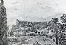
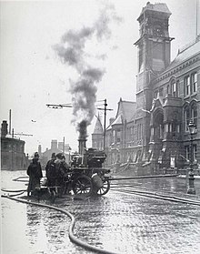
St Helens Town Hall built in 1876 to replace the original (damaged by a fire in 1871); its clock tower originally had a steeple but this was destroyed in a fire in 1913.
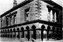
In the centre of the modern town centre, adjacent to the town hall, is the Gamble Institute, built in 1896 and named after Sir David Gamble, who was the first mayor and who also gifted the land for the building. Today, the Gamble Institute building serves as the central library and also houses other municipal offices and archives.
Other buildings of note are:
The Friends' Meeting House, Church Street. This attractive stone-built Grade II listed hall has been used for Quaker worship for over 300 years since its establishment, in 1678, by George Shaw of Bickerstaffe. A sign at the front of the building reads "so used" since 1678, partly leading local historians to believe the building had been used for another purpose for quite a number of years before 1678. The building and garden have been recently restored and are an important element of the George Street Conservation Area. The sundial over the door of the meeting house is dated 1753, while a curiosity in the garden is a huge glacial boulder, said to have been deposited from the Lake District following the last ice age.[75]
The Beecham Clock Tower, Westfield Street - which is now part of St Helens College. This was the original headquarters of the Beecham pharmaceutical empire.
St Mary's Lowe House Catholic Church, North Road is a Grade II listed building, opened in 1929, the second on this site (the land having been donated by Winifred Gorsuch Lowe - hence the name 'Lowe House'). The church is an unusual and striking landmark with a 130 ft (40 m) tower and a dome of a mixed Romanesque and Gothic style. The major feature is the historic Carillon[76] (bells playable using a keyboard, rather than by pulling ropes). It is the largest in the North West of England, housing 47 bells.[76]
The Roman Catholic Church of St Anne and Blessed Dominic, Monastery Road, Sutton, is a pilgrimage site for Roman Catholics. The Victorian missionary Blessed Dominic Barberi is buried in the church. Alongside Blessed Dominic, Father Ignatius Spencer is buried. The son of the 2nd Earl Spencer, he was a famed convert to the Roman Catholic faith. Elizabeth Prout, foundress of the religious order, the Sisters of the Cross and Passion, is also buried with them.
Geography
[edit]
The St Helens Borough covers roughly 30 km2 (12 sq mi) of soft rolling hills used primarily for agricultural purposes, mainly arable. The highest point in the borough, and in the whole of Merseyside, is Billinge Hill, 4+1⁄2 miles (7 kilometres) north of the town centre. From the top of this hill the cities of Manchester and Liverpool are visible on a clear day, as well as the towns of Wigan, Bolton and Warrington. The Mill Brook/Windle Brook runs through Eccleston and connects with the disused St Helens branch/section of the Sankey Canal in the town centre. St Helens is around 160 feet (50 metres) above sea level.
Carr Mill Dam is Merseyside's largest body of inland water, with lakeside trails and walks. It is used for national competitive powerboating and angling events.
Moss Bank, a suburb of St Helens, is about 4 km (2+1⁄2 mi) north of the town centre. It has a community library and St David's church.
The Burgies are two tailings on the site of the old Rushy Park coal mine. They were created by dumping toxic chemical waste from the manufacture of glass; they have since been covered with tall grass and woodland.
St Helens was struck by an F1/T2 tornado on 23 November 1981, as part of the record-breaking nationwide tornado outbreak on that day.[77] Damage from the tornado occurred in St Helens town centre.
Location
[edit]
St Helens is located 12 miles (19 km) to the east of Liverpool and 23 miles (37 km) from the centre of Manchester. The borough shares borders with the towns or boroughs of Prescot in Knowsley, Skelmersdale, Warrington, Widnes and Wigan; it has direct transport links by road and two main railway lines. Its centralised location has formed the basis of the local authority's promotional literature.[67]
The town is considered part of the Liverpool Urban Area for ONS purposes.[78]
Transport
[edit]Road
[edit]St Helens is well served by motorway links with the east–west corridors of the M58 and M62 to the north and south of the town. The town is also served by the parallel-running north–south routes of the M57 and M6 to the east and west.
The M6 runs a few miles to the eastern side of the town centre, with J23 at Haydock serving both northbound and southbound traffic and J24 at Ashton in Makerfield serving southbound exit and northbound access.
The M62 runs a couple of miles to the south of the town with J7 at Rainhill Stoops. The M57's J2 lies several miles south-west of St. Helens, at Prescot. The M58 is several miles north, at the north-western end of the A570 Rainford by-pass dual carriageway.
The A580 East Lancashire Road runs north of the town centre alongside Eccleston, Moss Bank and through Haydock. It is a dual-carriageway former trunk road taking traffic from Manchester to the Liverpool Docks. It was built between 1929 and 1934 and was opened by King George V. It was intended to take pressure away from the A58, a major road running from Prescot (M57) through St Helens to the A1(M) at Wetherby, West Yorkshire.
The Rainford by-pass is a section of the A570, between the East Lancashire Road and the M58; it is part of the transport route from Southport, in Sefton, through west Lancashire and St Helens to the M62 J7 at Rainhill.
A major development in communication was the opening of the dual-carriageway St Helens Linkway (classified as part of the A570) in 1994, which linked the town centre directly with the M62 (at Rainhill). The A572 takes traffic from the town centre through Parr to Earlestown and Newton-le-Willows. In July 2020, the St Helens Linkway grass verge was chosen by St Helens Borough Council as a site on which to plant yellow flowers in a large heart shape, in memory of all who had died during the coronavirus pandemic.[79][80]
In 2010, St Helens was proclaimed "UK's most car-friendly town" measured on variables such as "petrol prices, parking costs and the number of speed cameras in an assessment carried out by Virgin Money Car Insurance" in research conducted by The Independent newspaper.[81]
Buses
[edit]

Bus services to Wigan (320, 352), Liverpool, Widnes and Warrington operate from the town centre. St Helens has a central bus station that sits between Bickerstaffe Street and Corporation Street. A Merseytravel office is located on Bickerstaffe Street, where bus passes and advice can be sought.
From 1890, St Helens Corporation Transport organised public network services throughout the area, providing bus and trolleybus services. Following local government re-organisation in 1974, the Merseyside Passenger Transport Executive (Merseytravel) was expanded to cover St Helens. After privatisation in 1986, the town was served by several locally branded operations under the umbrella of Merseyside Transport Limited (MTL), in which Merseytravel retained shares until 1993.
Arriva purchased MTL in 2000 and has operated the majority of the routes since. Several smaller operators run specific routes within the town area, such as Cumfybus, Hattons, HTL Buses, Red Kite[82] Stagecoach Merseyside & South Lancashire and local municipal bus companies. There were also three zero-fare services operated by battery-electric minibuses in and around the town centre, ferrying passengers to nearby retail parks such as Ravenhead, which were provided on behalf of Merseytravel by Selwyns Travel. From 22 February 2014, these buses were withdrawn from service as part of a Merseytravel programme of spending cuts and due to the buses being at end of their operational lives.[83]
Railway
[edit]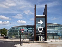
St Helens Central station serves the town centre. The stations of Thatto Heath, Eccleston Park and Garswood are on the Liverpool to Wigan Line that runs from Liverpool Lime Street to Wigan North Western.
The Liverpool to Manchester line serves the St Helens area at Rainhill, Lea Green and St Helens Junction before passing on to Earlestown and Newton-le-Willows. The St Helens Junction and Rainhill buildings are two of the original stations that were built when the line opened in 1830.
Until the 1950s, three railway lines ran through St Helens:
- the current line from Liverpool Lime Street, through Huyton and St Helens, to Wigan North Western;
- a line from Widnes, through St Helens, to Rainford;
- a line starting at St Helens, running east through Haydock, to Lowton St Mary's on the LNER Wigan Junction line.
A major redevelopment of St Helens Central station was completed in 2007 at a cost of £6.2 million,[71] which the council hoped would encourage investment, create more jobs and improve the gateway into the town. The building has been constructed using copper on the fins, in reference to the town's early industrial heritage.[71]
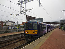
В 2010 году правительство было подтверждено, что будет осуществляться электрификация как Ливерпуль, так и Ливерпуль в Линии Уигана, а национальная сеть Body объявила о прогнозируемой общей дате завершения 2014 года. Network , операционная компания поезда, объявила о внедрении электроэнергии на линии с начала новой смены расписания 17 мая 2015 года. Служба Ливерпуля до Уигана управлялась электрическими единицами класса 319 класса 319 с 2015 по 2023 год. В настоящее время управляется 3 и 4 единицами CAR CAF CAFICTION CLASS 331.
Городской совет Сент -Хеленс обсудил возможность новой железнодорожной станции в Карр -Милл в Лаффаке .
Водные пути
[ редактировать ]Сент -Хеленс - город с вылезами, но он имеет легкий доступ к портам Ливерпуля, на реке Мерси и Мостин и Северный Уэльс на реке Ди. Канал Санки, в том числе секция Сент -Хеленс, больше не используется для перевозки товаров; Он состоит только из нескольких коротких секций, а остальные истощены и заполнены.
Воздух
[ редактировать ]Ближайший аэропорт-это аэропорт Ливерпуля Джона Леннона , расположенный примерно в 12 милях (19 км) к юго-западу от города и связан с частой службой автобусной станции Сент-Хеленс (89). По дороге, к нему обращается через Сент -Хеленс Линсвей в западном направлении M62 в Rainhill. В настоящее время не существует прямого железнодорожного соединения, хотя некоторые поезда, вызывшие в Сент -Хеленс Централ, теперь отправляются на станцию Ливерпуль Южный Паркуэй , на которых есть автобусы, соединяющие аэропорт.
Аэропорт Манчестера находится примерно в 25 милях (40 км). По дороге, доступ к нему доступен через Сент -Хеленс Линквей в M62 в восточном направлении J7 в Rainhill и по железной дороге; Поездка на поезде в аэропорту Манчестера обслуживает станцию Junction St Station.
Прошлые ссылки
[ редактировать ]
Обширная система трамвайных и троллейбусов работала в период с 1880 по 1936 год. Службы троллейбуса начались в 1927 году и прекратились 30 июня 1958 года, когда последняя троллейбус Прескота Круга была заменена автобусным обслуживанием. С 1919 года служба управлялась трамваями Сент -Хеленс Корпорации ; До этого он управлял компанией St Helens и District Tramways, а затем новой компанией St Helens и District Tramways . Первоначально нарисованная лошадью, они стали паром, работавшими в 1890 году, а затем к электричеству к 1899 году. Первоначальные линии были удалены во время войны за сталь для военных действий. Единственные трамвайные дорожки, оставшиеся, можно увидеть в транспортном музее, и один изолированный полюс троллейбуса, который несет линии электропередач, все еще можно увидеть на Уоррингтон -роуд, Пизли Кросс.
Также существовало трамвайное звено, в Уиндл и в Хейдоке, последний служит Ливерпулю через узловой пепел .
Управление
[ редактировать ]Гражданская история
[ редактировать ]
Сент-Хеленс впервые стал ответственностью за администрирование более широкой области в 1836 году, когда он стал регистрационным подрадийным районом Прескот-прихода в рамках Закона о муниципальных корпорациях 1835 года , который передал контроль над более локализованным контролем прихода (подстегнутый в соответствии с Законом о реформе 1832 ).
Сент -Хеленс, в твердой четке Уиндл, построил свою первоначальную ратушку в 1839 году, которая служила юридическим судом, домом собраний и административным центром. Он также провел заседания совета как для олдерменов , так и прихожан.
В 1868 году Сент -Хеленс был включен в районе (охватывая 4 поселка). В ответ на старый, меньший, Холл страдает от повреждения пожара в 1872 году, был запланирован новый зал. Эта нынешняя ратуша была построена между 1872 и 1876 годами. В 1889 году Сент -Хеленс снова была реформирована, на этот раз как район округа с большей ответственностью за увеличение площади земли. Это было частью продолжающегося процесса реструктуризации местного самоуправления в викторианскую эпоху, на этот раз в рамках Закона о муниципальных корпорациях 1882 года .
Как округ, Сент -Хеленс был с 1889 по 1974 год в графстве Ланкашир административном . 1 апреля 1974 года в соответствии с положениями Закона о местном самоуправлении 1972 года Сент -Хеленс стал административным центром столичного района Сент -Хеленс в недавно созданном Мерсисайд округе . В это время городской совет Сент -Хеленс заменил все местные советы в предписанном районе.
Исторический герб
[ редактировать ]
Город и Герб -герб 17 января 1876 года был предоставлен Старый . Черный Крест ссылается из семьи Экклстонов. Соленники в первой и четвертой кварталах взяты из рук Джерардов Виндсшоу. «Второй и третий грифон Сегриант» тем временем взят из смелой семьи. Голубые батончики из рук семьи Парр, маркизах Нортгемптона. Лев из гребня Уолмсли, а два Флеурс-де-Ли относятся к сэру Дэвиду Гамблу, первого мэра и благотворителя города и семьи Хейдока.
Поскольку совет прекратил существовать в 1974 году, эти руки с тех пор больше не используются. Герб нынешнего совета столичного района Сент -Хеленс принял часть своего дизайна.
Девиз
[ редактировать ]Девизом был латинский "Ex Terra Lucem" . Буквальный перевод будет «с земли, свет», в то время как более описательные переводы могут быть «светом из земли» или «из земли приходят свет». Фраза относится как к обильным, так и в выигрышном угольном ресурсе (которые могут быть сожжены, для производства «света») в дополнение к их использованию в местной промышленности, такой как стекло (через которое проходит свет).
Девиз города и более крупного района был изменен в 1974 году на «Prosperitas in Excelsis» («успех в высшем» или «процветающий колодец»), который включен в оружие столичного городского совета.
После открытия летних Олимпийских игр 2012 года церемонии Фрэнк Коттрелл Бойс, творческий писатель за церемонией открытия Дэнни Бойла , показал, что городской девиз оказал значительное влияние на олимпийский котел, разработанный Томасом Хизервиком . Лепестки котла, когда -то зажгли, начались на полу и поднялись, чтобы сформировать один факел. [ 84 ]
Успех и громкий профиль игр заставили Совет и местных жителей рассмотреть вопрос о повторной афориации «ex terra lucem». Считалось, что это было более подходящим для истории города и имело больше смысла для местных жителей, представляющих надежду на будущее. Несколько человек подняли это и попросили, чтобы Совет рассмотрел рассмотрение замены девиза.
Общественная консультация началась 17 января 2013 года, и на его заседании, состоявшемся 17 апреля 2013 года, Совет решил вернуться к первоначальному девизу "Ex Terra Lucem". Групчак остался прежним. [ 85 ]
Парламентское представительство
[ редактировать ]Сент -Хеленс представлена Сент -Хеленс Юг и Уистон и Сент -Хеленс Север . Оба содержат районы за пределами границы города, но внутри Большого района. Каждый избирательный округ отправляет 1 представителя в парламент.
На всеобщих выборах в 2015 году Дэйв Уоттс и Шон Вудворд стояли со своих мест. Депутат Дэвида Уоттса (Сент -Хеленс Север) был действующим с 1997 года, в то время как Shaun Woodward MP (Сент -Хеленс Юг и Уистон) сохранял свое место с 2001 года. Уоттс получил пожизненный пираг и стал Бароном Уоттсом в декабре 2015 года. [ 86 ]
Конор Макгинн (Сент -Хеленс Север) и Мари Риммер (Сент -Хеленс Юг и Уистон) были выбраны в качестве кандидатов на лейбористской партии , и оба были избраны в качестве депутатов в 2015 году.
Риммер и Макгинн оба занимали свои места на всеобщих выборах 2019 года. [ 87 ]
В 2024 году Макгинн стоял, и Дэвид Бейнс , также из лейбористской партии, был избран.
Город считается оплотом труда и имеет «безопасные (трудовые) места».
Представительство местного совета
[ редактировать ]Сент -Хеленс и связанные с ним палаты представлены городским советом Святого Хеленса. [ 88 ]
Совет управлял лейбористской партией с первых выборов в 1973 году, пока альянс между либеральными демократами и консерваторами не принял под контроль после выборов 2006 года . Труд восстановил большинство на выборах 2010 года , и по состоянию на выборы 2014 года Совет состоял из следующих советников : [ 89 ]
| Вечеринка | Советники | |
| Лейбористская партия | 42 | |
| Либеральные демократы | 3 | |
| Консервативная партия | 3 | |
После местных выборов 2022 года состав городского совета Сент -Хеленс был следующим: [ 90 ]
| Вечеринка | Советники | |
| Лейбористская партия | 29 | |
| Либеральные демократы | 4 | |
| Консервативная партия | 2 | |
| Независимые | 7 | |
| Зеленый | 6 | |
Приходские советы
[ редактировать ]Сент -Хеленс также обслуживается несколькими приходскими советами. Их деятельность значительно снижена в современном районе, но все еще активна в общинах и признается городским советом [ 91 ] Поскольку они могут «выполнять многие обязанности, такие как уличное освещение, управление кладбищами, выделения, общины, деревенские залы, военные мемориалы, рынки и т. Д.».
Городской совет Святой Хеленс перечисляет приходские советы как:
- Биллинг Приходский совет
- Смелый приходский совет
- Приходский совет Экклстона
- Приходский совет Рейнфорда
- Приходский совет Rainhill
- Совет Сенели Грин Приход
- Виндл Приходский совет
Демография
[ редактировать ]Христианство является основной религией в районе Сент -Хеленс. В переписи 2001 года об этом сообщалось примерно на 87%. Это сделало Сент -Хеленс «самый христианский город в Британии» в то время. [ 78 ] [ 92 ] Святой Хеленс также имел второе наименьшее количество людей (из 376 местных властей), которые активно называют себя вообще не имеют религии. [ 78 ]
В Сент -Хеленсе очень мало этнических меньшинств, среди самых низких уровней в стране. 98,84% населения Сент -Хеленс назвали себя белыми британцами в 2001 году. [ 93 ] Самое большое этническое меньшинство в Сент -Хеленсе в 2001 году было зарегистрировано как индийское с 409. [ 78 ]
К 2006 году сообщество переходных цыган и путешественников обогнало это число и теперь считается «составляющей крупнейшую идентифицируемую группу этнических меньшинств в Сент -Хеленс». [ 94 ]
Образование
[ редактировать ]Начальные школы
[ редактировать ]В районе Сент-Хеленс есть одна детская школа, одна школа для младенцев, одна младшая школа, пятьдесят две начальные школы и одна независимая школа для учеников в возрасте 3–16 лет. Производительность на ключевом этапе 1 и ключевой стадии 2 SATS постоянно превышала средние значения национальных средних.
Школы для детей с особыми образовательными потребностями
[ редактировать ]В Сент -Хеленс - три школы SEN - Пенкфорд, Милл Грин и Бридж Лансбери.
Средние школы
[ редактировать ]У района Сент -Хеленс есть один независимый и девять, поддерживаемые средним школами:
Дальнейшее образование
[ редактировать ]В городе есть семь образовательных учреждений, предлагающих образование после 16 лет в: Международный колледж Коули , Рейнфордский колледж с высоким технологиями , среднюю школу Рейнхилла и шестой центр форм, Академия Саттона , Академия Хоуп- (все 11-18 средних школ), колледж Кармел (А. Шестой формы колледжа) и колледж Сент -Хеленс (общий колледж FE). Carmel College является ведущим колледжем в стране с баллом с добавленной стоимостью 328. Колледж является партнером Университета Ливерпуля . Колледж Сент -Хеленс, который недавно восстановил свой кампус города Центра, предлагает широкий спектр курсов по более высоким и дальнейшим образованию, включая курсы по получению дипломов, степени фонда, BTECS и профессиональную квалификацию в бизнес -школе колледжа. Колледж имеет растущую репутацию своих стандартов и достижений. Недавно колледж Сент -Хеленс открыл университетский центр. Местные жители, которые остаются в этом районе и ходят в университет, часто пользуются окрестностями, такими как: Edge Hill ( Ormskirk ), Ливерпуль , Манчестер , Солфорд и Честер . Палата Св. Елена является сильным поставщиком школьного выпускника и обучения после 16 лет и курсов.
СМИ
[ редактировать ]Существует одна местная еженедельная газета « Сент -Хеленс звезда» , которая свободно распространяется и доступна для покупки в супермаркетах, и публикуется каждый четверг.
Местные новостные и телевизионные программы предоставляются BBC North West и ITV Granada . Телевизионные сигналы получены от телевизионного передатчика Winter Hill . [ 95 ]
Местные радиостанции- BBC Radio Merseyside , Heart North West , Radio City , Greatest Hits Radio Wigan & St Helens (ранее Wish FM, названная в честь Wigan (WI) и St Herens (SH)) и, Radio Radio, интернет-сообщество Радиостанция, базирующаяся в Сент -Хеленсе.
Колледж Сент -Хеленс ранее производил временные, ограниченные услуги FM -радиопередачи из их кампуса Town Center. В декабре 2010 года радиостанция в колледже Сент-Хеленс повторно связала вещание под баннером «Солнечная 1287».
Культура и досуг
[ редактировать ]
Музеи
[ редактировать ]Расположенный в центре города, музей World of Glass открылся в 2000 году, включающий музей стекла Пилкингтона и местный музей Сент -Хеленс.
Северо -западный музей дорожного транспорта - еще один музей, расположенный в городе. Центр наследия Chemity - это небольшой музей в Килн -лейн, Экклстон, о работах местного кузнеца .
Парки, открытые пространства и прогулки на природе
[ редактировать ]У района Сент -Хеленс есть несколько крупных парков и открытых пространств. К ним относятся парк Тейлор, исторический парк и сад, в котором открылись исторический парк и сад, а также парк Виктория, расположенный недалеко от центра города.
Sherdley Park была Funfair - это современный парк в Саттоне, в котором летом , обычно в июле, называемый фестивалем Сент -Хеленс (первоначально названный The Helens Show), это был один из крупнейших бесплатных фестивалей в Европе.
Парр имеет парк Гаскелл в дополнение к восстановленному открытому пространству, известному как уставки (или Ashtons Green), и разделяет границу с заболоченными пустошами, известными как «Мос» или «Коллиерс Мосс» (традиционно связана с жирным жирным хозяйством и ее электростанцией), и область, известная как «вспышка» (остатки приточной системы канала и рыболовные пруды) с природой, прогуливаясь по части маршрута 7 миль (11 км), который состоит из странового парка долины Санки (часть Транс -Пеннинской тропы ) [ 96 ] [ 97 ] [ 98 ] [ 99 ]
высотой 20 м Скульптура , называемая Dream , была возведена на бывшей Colliery в Саттон -поместье в Сент -Хеленс. [ 100 ]
Gaskell Park, Taylor Park и The Duckeries - все получили статус премии Green Flag в 2009 году. King George V Park получил награду Green Flag в 2012 году. [ Цитация необходима ]
Театр
[ редактировать ]Театр Цитадели
[ редактировать ]Первый Theatre Royal был построен на Бридж -стрит, открытый в 1847 году [ 31 ] и был большой деревянный сарай. Это было открыто в течение нескольких сезонов, пока тяжелый снег не вызвал разрушения крыши. [ Цитация необходима ] Он был заменен новым королевским театром на Молочной улице.
Revill построил новый театр на Корпорации -стрит и вместо этого перенес это королевское имя театра.
Театр Молочной улицы был затем куплен Армией спасения, где он был более или менее полностью переработан внутри. Он был переименован в CI Citadel и использовался для этой цели в течение почти 90 лет, пока Армия спасения не перешла на новый участок. Затем он был открыт в качестве Центра искусств Цитадели в 1988 году и был отремонтирован в 2000 году. [ 101 ]
В 2019 году было объявлено, что Центр искусств Цитадели закроется 30 июня 2019 года, но благотворительная организация Citadel Arts продолжит работать при поддержке краудфандинговой кампании. [ 102 ]
Театр Королевский
[ редактировать ]
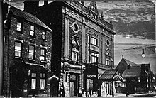

Королевский театр, открытый Revill на Корпорации-стрит в 1889 году, был относительно недолговечным, поскольку он был серьезно поврежден пожаром в 1901 году. [ 103 ] Затем он был реконструирован уважаемым театральным архитектором Фрэнком Матчамом . [ 103 ] [ 104 ] Театр Matcham был разработан в стиле барокко с украшенными балконами, люстрами и коробками. [ 103 ] В 1960 -х годах театр был куплен Pilkingtons и был потрошен внутри. [ 103 ] Аудитория была отремонтирована, сняв все следы оригинального дизайна интерьера, в то время как богато украшенный фасад был заменен простым стеклянным фасадом. Впоследствии это было сильно отремонтировано в 2001 году.
Театр сегодня - это место с туристическими актами и ежегодной пантомимой. Есть выступления местных любительских оперных и драматических обществ, школ и танцевальных академий.
Спорт
[ редактировать ]Регби -лига
[ редактировать ]Профессионал
[ редактировать ]Сент -Хеленс является домом для Сент -Хеленс RFC , известный в спорте как «Святые», которые играют в Британской Суперлиге . Клуб был основан в 1873 году и был одной из основателей футбольной лиги регби в 1895 году. Они сыграли свои домашние игры на Knowley Road в Экклстоне с 1890 года, но в 2012 году переехали на современный стадион в Лэнгтри -Парке . Клуб имеет историческое соперничество с Wigan Warriors . Они были одной из самых успешных команд современной эпохи Суперлиги.
Любитель
[ редактировать ]
Город также является домом для большого количества команд лиги регби -любителей, включающих в себя старшие и молодежные команды. Наиболее заметными из них являются Blackbrook Arlfc , [ 105 ] Смелые шахтеры, шахтеры с часами, Haresfinch Hawks, Haydock Warriors, Pilkington Recs [ 106 ] И это Крестоносцы -Крестоносцы . [ 107 ] Большинство из этих команд и других в этом районе соревнуются на соревнованиях округов Барла Северного Запада (Pilkingtons в Премьер -лиге, Хейдок и Блэкбрук в 1 -м дивизионе, так и часы во втором дивизионе). Там, кто соревнуются в высшей лиге национальной конференции .
Blackbrook Royals внесла 26 победных сторон в Ланкашире в 8 возрастных диапазонах от U12 до U18, причем две в категории открытого возраста в категории открытого возраста [ 105 ] и 10 национальных кубков. Pilkington Recs имеет 17 побед (и в 6 раз, заняв второе место), и для этого, 10. [ 108 ]
Команды RFC ST HELENS RFC до 18 лет и 16S и Сент -Хеленс Академии RFC служат официальными кормушками для святых.
Регби Союз
[ редактировать ]
Сент -Хеленс является домом для нескольких любительских команд по регби. Ливерпуль Сент -Хеленс ФК - самая выдающаяся команда профсоюзов в городе, где код лиги имеет приоритет. Команда утверждает, что является «самым старым открытым клубом регби в мире», основанным на его происхождении в формировании футбольного клуба «Ливерпуль» (не путается с одноименной футбольной командой Ассоциации) в 1857 году.
Ливерпуль Сент -Хеленс работает, в дополнение к своей первой команде, как многочисленных старших, Кольтс, так и юношеских команд, и, кроме того, имеют команду по регби U18 и U15 в рамках их подхода «открытые» и инклюзивного регби. В 2008 году клуб объявил о открытии своего центра совершенства в координации с SportsMatch (Департамент спортивной Англии ).
Несколько местных социальных, спортивных и досуговых клубов принимают свои собственные команды, в том числе самый успешный клуб в городе недавней истории Западный Парк Сент -Хеленс (обычно называемый просто Вест -Парк), [ 109 ] В настоящее время это играет в Национальной лиге 3 North и Ruskin Park RFC, которые в настоящее время играют в северном дивизионе 3 West. [ 110 ]
Ассоциация футбола
[ редактировать ]Сент -Хеленс Таун ФК является любительским английским футбольным клубом, который в настоящее время играет в первом подразделении Премьер -лиги округа Ливерпуль . Клуб, ранее играл в свои игры на Knowley Road, они затем переехали, чтобы сыграть в Ashton Athletic FC, и теперь играют на Ruskin Drive Sports. Св. Хеленс Таун ФК выиграл вазу FA в сезоне 1986–87 годов, победив местных соперников Warrington Town FC 3-2 в финале на стадионе Уэмбли .
ФК Сент -Хеленс находится в первом дивизионе к северу от футбольной лиги округов Северо -Запад . Пилкингтон ФК также находятся в первом подразделении Лиги округов Северо -Запад.
Ранее в городе была собственная любительская футбольная лига, футбольная комбинация Сент -Хеленс и район , которая проходила с сезона 1917–18 до 2016 года.
В 2009 году бразильские футбольные школы Сент -Хеленс запустили специализированные центры футбола и футбола в регионе, чтобы преподавать футбол для младших и молодежных игроков.
Крикет
[ редактировать ]Сент -Хеленс является домом для нескольких любительских сторон крикета. Cricket Club St Helens, сформированный в 1843 году, был распущен в 2012 году. Сент -Хеленс отдых Club Club, сформированный в 1847 году, в настоящее время является самым старшим клубом в городе и играет в конкурсе «Ливерпуль и окружной крикет» .
У Саттона, Хейдока, Рейнхилла и Ньютона Ле Уиллоу также есть свои местные клубы по крикету с представительством от 11 до нескольких старших команд.
Другие виды спорта
[ редактировать ]Город раньше был домом для любительской американской футбольной команды Сент -Хеленс Кардиналс. Кардиналы были активны в период с 1984 по 1998 год , выиграв Чемпионат UKAFL в 1987 году с 28–26 победами над Ipswich Cardinals . В 2019 году Сент-Хеленс Кардиналс был реформирован, чтобы сыграть в формате игры 8 на 8 в рамках Британской лиги Gridiron.
Грейхаундные гонки состоялись в двух местах; На гоночном и спортивном стадионе Сент -Хеленс (1932–1993) и вокруг поля на стадионе Хогтон -роуд (1993–2001). Гонки были независимыми (не связаны с спортивным руководящим органом Национального гоночного клуба борзых ), и они были известны как хлопья, который был прозвищем, данным независимым трекам. [ 111 ] [ 112 ]
Шахтеры Сент -Хеленса (позже известные как северо -западные шахтеры ) были австралийским футбольным клубом правил, базирующимся в городе. Сформированный в 2002 году, клуб принял участие в 3 сезонах с 2002 по 2004 год. [ Цитация необходима ]
Молодежные организации
[ редактировать ]Разведчики
[ редактировать ]Скаут был активен в Сент -Хеленсе с 1907 года, и с тех пор движение непрерывно активно активно. Первый официальный скаутский отряд открылся в YMCA в 1908 году. [ 113 ] Группа была открыта после визита в Сент -Хеленс в 1908 году самим лордом Бадену Пауэллом. [ 114 ]
В 2007 году округ отпраздновал свой столетие 100 -летнего разведки по всему городу с целым районным лагерем в местном поместье Бисфам -Холл Скаут.
В 2018 году район принял новую стратегию для жизни и брендинг для британского скаутского движения. [ 115 ]
У района есть штаб -квартира в Саттон Лич. Район владеет специально построенной скаутской хижиной и окружающей землей, открытой для всех членов округа.
Текущие группы разведчиков и разделы
[ редактировать ]Этот раздел может содержать чрезмерное количество сложных деталей, которые могут заинтересовать только конкретной аудитории . ( Декабрь 2023 г. ) |
- 1 -я Сент -Хеленс (YMCA)
- 1 -й знаний (собственный граф Дерби)
- Whiston и Huyton - формально 28 -й Сент -Хеленс и 1 -й Уистон
- 2 -й Сент -Хеленс (Парк Экклстон)
- 4 -я Сент -Хеленс (Сент -Энн)
- 5 -я Сент -Хеленс (Rainhill Open)
- 6 -я Сент -Хеленс (PARR)
- 8 -я Сент -Хеленс (Саттон приход)
- 10th St Helens (Rainford)
- 11th St Helens (Toll Bar)
- 13th Knowley (приходская церковь Huyton) - объединен с 1 -й Уистоном в 2023 году
- 15 -я Сент -Хеленс (Сент -Эндрюс)
- 16 -я Сент -Хеленс (Сент -Томас)
- 18 -й Сент -Хеленс (Хейдок)
- 21-я Сент-Хеленс (Ньютон-ле-Уиллаус)
- 23 -я Сент -Хеленс (Экклстон)
- 25 -я Сент -Хеленс (Биллинг)
- 26 -я Сент -Хеленс (Блэкбрук)
Кадетские силы
[ редактировать ]Все три военные кадетские силы присутствуют в Сент -Хеленс; они существуют:
- 969 (Сент -Хеленс) Эскадрилья - местная эскадрилья воздушных кадетов Королевских ВВС [ 116 ]
- Мерсисайдская армейская кадетская сила имеет отряд курсантов, базирующийся в юбилейных казармах, который связан с полком 103 , штаб -квартира Королевской артиллерии . [ 117 ]
- Корпус Sea Cadet , поддерживает обучающий корабль Scimitar , в казармах Милл -стрит . [ 118 ]
Культурные ссылки
[ редактировать ]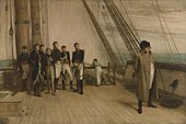
Знаменитый Punch, мультфильм основанный на картине Наполеона на борту Bellerophon , выставленной в 1880 году сэром Уильямом Квиллером Орчардсоном , имел подпись: «Он совершенно убежден, что его изгнали в Святой Хелен, бедный дьявол!». Это было каламбуром на Святой Елене , на острове Южной Атлантики, на который был изгнан Наполеон.
Примечательные люди
[ редактировать ]
Международные ссылки
[ редактировать ]Сент -Хеленс - двойной с:
 -Chalon -Sur-saône , Saône-Et-Loire , Bourgogne-Franche-Comté , Франция [ 119 ]
  - Штутгарт , Баден-Вюртемберг , Германия [ 120 ]
Смотрите также
[ редактировать ]Ссылки
[ редактировать ]- ^ «Координатный калькулятор расстояния» . Boulter.com . Получено 8 марта 2016 года .
- ^ Jump up to: а беременный в Льюис, Самуил, изд. (1848). Топографический словарь Англии . Хедон - Хелмингтон. С. 466–470. ISBN 0-8063-1508-3 .
- ^ Jump up to: а беременный в ГБ Историческая ГИС / Университет Портсмута. «История Сент -Хеленс в Ланкашире» . Visionofbritain.org.uk.
- ^ Перепись 2001 года . Поступок
{{cite web}}: CS1 Maint: числовые имена: список авторов ( ссылка ) - ^ Перепись 2021, ONS. «Как жизнь изменилась в Сент -Хеленсе: перепись 2021» . Управление по национальной статистике . Получено 23 февраля 2023 года .
{{cite web}}: CS1 Maint: числовые имена: список авторов ( ссылка ) - ^ Университет Портсмута. «Административная единица западного дерби Сто» . Visionofbritain.org.uk. Архивировано из оригинала 23 мая 2016 года.
- ^ Уильям Фаррер и Дж. Браунбилл (1907). «История графства Ланкастер: том 3» .
- ^ Отчет Палаты общин. «Рейвенхедс причина, доставленная в парламент, 2001 год» . Парламент.uk.
- ^ Стивен Даглиш (14 апреля 2007 г.). "Даглиский литейный завод, Сент -Хеленс" . daglishfamily.blogspot.com.
- ^ Jump up to: а беременный в дюймовый и фон глин час я Дж k л м Barker, TC & Harris, JR (1994). Город Мерсисайд в промышленной революции: Сент -Хеленс, 1750–1900 . Routledge . С. 3–11. ISBN 0-7146-4555-9 .
- ^ Св. Хеленс Хоральное общество. «Происхождение Святой Хеленс» . sthelenschoralsociety.org. Архивировано из оригинала 28 июля 2011 года.
- ^ Jump up to: а беременный Barker, TC & Harris, JR (1994). Город Мерсисайд в промышленной революции: Сент -Хеленс, 1750–1900 . Routledge. С. 108–120. ISBN 0-7146-4555-9 .
- ^ Jump up to: а беременный Barker, TC & Harris, JR (1994). Город Мерсисайд в промышленной революции: Сент -Хеленс, 1750–1900 . Routledge. С. 202–223. ISBN 0-7146-4555-9 .
- ^ Jump up to: а беременный Barker, TC & Harris, JR (1994). Город Мерсисайд в промышленной революции: Сент -Хеленс, 1750–1900 . Routledge. С. 120–131. ISBN 0-7146-4555-9 .
- ^ Jump up to: а беременный в дюймовый Barker, TC & Harris, JR (1994). Город Мерсисайд в промышленной революции: Сент -Хеленс, 1750–1900 . Routledge. С. 223–246. ISBN 0-7146-4555-9 .
- ^ Jump up to: а беременный Barker, TC & Harris, JR (1994). Город Мерсисайд в промышленной революции: Сент -Хеленс, 1750–1900 . Routledge. С. 75–90. ISBN 0-7146-4555-9 .
- ^ Глава, Джордж (1836). Домашний тур по производственным районам Англии, летом 1835 года . Харпер и братья. С. 78–83 .
- ^ Barker, TC & Harris, JR (1994). Город Мерсисайд в промышленной революции: Сент -Хеленс, 1750–1900 . Routledge. С. 90–108. ISBN 0-7146-4555-9 .
- ^ [ 10 ] [ 11 ] [ 12 ] [ 13 ] [ 14 ] [ 15 ] [ 16 ] [ 17 ] [ 18 ]
- ^ Археологическое общество Уигана. "Селтик -Уиган" . Wiganarchsoc.co.uk.
- ^ Археологическое общество. "Римский Уиган " Wiganarchs.co.un.
- ^ Jump up to: а беременный в дюймовый и фон глин час Farrer, William & Brownbill, J (1907). История графства Ланкастер: том 3 . История округа Виктория. С. 362–367. Раздел, посвященный Экклстону.
- ^ Jump up to: а беременный в дюймовый и фон глин час я Дж k л м не а п Q. ведущий Farrer, William & Brownbill, J (1907). История графства Ланкастер: том 3 . История округа Виктория. С. 354–362. Раздел посвящен Саттону.
- ^ Jump up to: а беременный в дюймовый и фон глин час я Дж k л м не Farrer, William & Brownbill, J (1907). История графства Ланкастер: том 3 . История округа Виктория. С. 371–377. Секция посвящена Виндл.
- ^ Jump up to: а беременный Farrer, William & Brownbill, J (1907). История графства Ланкастер: том 3 . История округа Виктория. С. 377–382. Раздел, посвященный Parr.
- ^ Jump up to: а беременный в дюймовый и фон глин час Barker, TC & Harris, JR (1994). Город Мерсисайд в промышленной революции: Сент -Хеленс, 1750–1900 . Routledge. С. 11–23. ISBN 0-7146-4555-9 .
- ^ Barker, TC & Harris, JR (1994). Мерсисайд Город в промышленной революции: Сент -Хеленс, 1750–1900 . Routledge. п. 14. ISBN 0-7146-4555-9 Полем
Свидетель Джон Эйз, 28. февраля 1745 года Комитету Палаты общин, связанного с фондом Магистрали, «Потому что Прескот, находясь в трех милях ближе к Ливерпулю, чем Сент -Хеленс, люди, естественно, пойдут в прежнее место для углей, если они могут быть Поставляется также и так же дешево, как на последнем ».
- ^ Jump up to: а беременный в Martindale, A (1845). Жизнь Адама Мартиндейла, написанная самим собой . Штамское общество, из рукописи в Британском музее.
- ^ Jump up to: а беременный в дюймовый Лонг, Джордж, изд. (1839). Пенни циклопедия Общества по распространению полезных знаний, тома 13-14 . Чарльз Найт и Пенни Журнал.
- ^ Jump up to: а беременный в дюймовый и фон глин Уилсон, Джон Мариус (1874). Императорский газетер Англии и Уэльса (1870–1872) . A. Fullarton & Co.
- ^ Jump up to: а беременный в дюймовый и фон глин час я Дж k л м не а п Q. ведущий с Т в v В х и Флетчер, Майк (2002). Черное золото и горячий песок: история Сент -Хеленс . Carnegie Publishing Ltd. ISBN 978-1-85936-088-0 .
- ^ Farrer, William & Brownbill, J (1907). История графства Ланкастер: том 3 . История округа Виктория. С. 402–409. Раздел, посвященный жирным жирным шрифтам.
- ^ Фаррер, Уильям (1910). Последние согласия для Ланкашира, часть 4: 1509–1558 . История округа Виктория.
- ^ Farrer, William & Brownbill, J (1911). История графства Ланкастер: том 4 . История округа Виктория. С. 150–154. Секция посвящена Byroms.
- ^ Мерси Форест. «Обзор леса Мерси» . merseyforest.org.uk.
- ^ Приходская церковь Святой Хеленс. «История приходской церкви Святой Хеленс» . sthelensparishchurch.org. Архивировано из оригинала 14 ноября 2009 года . Получено 1 августа 2010 года .
- ^ Сайрус Реддинг (1844). Изображенная история графства Ланкастер . Джордж Рутледж. С. 89 –137.
- ^ Jump up to: а беременный Варфоломей, Джон (1887). Gazetteer Британских островов . А. и С. Блэк, 1887. с. 534. ISBN 0-00-448835-0 .
- ^ Jump up to: а беременный Университет Портсмута. «Район Святой Хеленс: общее население» . Visionofbritain.org.uk.
- ^ Обозребл . «Обследование боеприпасов и исследование боеприпасов в Шотландии первая серия» . Visionofbritain.org.uk предоставлен Британской библиотекой.
- ^ «Место встречи TA восстановлено в бывшую славу» . Ливерпуль Эхо. 1 июля 2013 года . Получено 8 сентября 2017 года .
- ^ Университет Портсмута. «Административная единица St Helens MB/CB» . Visionofbritain.org.uk. Архивировано из оригинала 24 декабря 2012 года.
- ^ «Общественный художественный проект для сайта M62» . BBC онлайн. 23 июля 2007 г. Получено 27 мая 2009 года .
- ^ «Канал 4 крупного художественного проекта в Сент -Хеленсе» . Сент -Хеленс Совет. Архивировано из оригинала 13 февраля 2008 года.
- ^ «Канал 4 Big Art Project; сайт Colliery Sutton Manor» . Big Art St. Helens. Архивировано из оригинала 16 апреля 2009 года . Получено 23 мая 2010 года .
- ^ Килмуррей, Эндрю, изд. (20 августа 2009 г.). «Пусть будет свет на сон Святой Хеленс, скажем, бывшие минеры» . Получено 23 мая 2010 года .
- ^ Коэн, Иехуди А. (1968). Человек в адаптации: культурный подарок . Чикаго, Aldine Pub. Ко. 468 . ISBN 0-202-01109-7 .
- ^ «Соседи сражаются с планами Opencast Mine» . Сент -Хеленс: репортер. 22 июня 2009 г. Получено 1 августа 2010 года .
- ^ Jump up to: а беременный Журнал истории транспорта, тома 2-3 . Манчестерское университетское издательство. 1955. С. 175–176.
- ^ "Sutton Manor Colliery (1906-1991)" . Ямр.орг .
- ^ Кослетт, Пол (23 февраля 2009 г.). «Выбор между головой и сердцем» . BBC онлайн . Получено 21 июня 2010 года .
- ^ «Саттон усадьба леса в Сент -Хеленс» . Саттон красавица . Получено 21 июня 2010 года .
- ^ Взято из Сент Казино . -Хеленс
- ^ «Основные ассоциации в Сент -Хеленсе - регион Ливерпуль -Сити | Ливерпуль | Виррал | Сефтон | Сент -Хеленс | Знаетли | Халтон» . LiverpoolcityRegion.uk . Получено 6 июля 2018 года .
- ^ Jump up to: а беременный Городской совет Святой Хеленс (29 сентября 1994 г.). «29sep94 Великобритания: планирование - ул. Хеленс, Мерсисайд - Бертонхед Роуд, M62 Link Road» . Cnplus.co.uk .
- ^ Совет, Сент -Хеленс. «Совет Сент -Хеленс» . Sthelens.gov.uk . Получено 5 июля 2020 года .
- ^ «Герои собираются для торжественного открытия нового магазина» . Звезда Святой Хеленс . 31 октября 2011 года . Получено 5 июля 2020 года .
- ^ «Новый магазин принесет 150 рабочих мест в Сент -Хеленс» . Звезда Святой Хеленс . 6 июня 2012 года . Получено 5 июля 2020 года .
- ^ «Langtree Group Plc - Стадион Сент -Хеленс - Vision» . Sthelensstadium.com. Архивировано из оригинала 24 июля 2010 года . Получено 3 августа 2010 года .
- ^ Tesco
- ^ Консультанты по землепользованию. «Оценка ландшафта для Сент -Хеленса, окончательный отчет» . Городской совет Святой Хеленс. Архивировано из оригинала 24 июля 2011 года.
- ^ «10 -летний отчет о северо -западном региональном развитии» (PDF) . NWDA. Архивировано из оригинала (PDF) 26 ноября 2010 года.
- ^ «Обновление по соседству с правительственной страницей» . Архивировано из оригинала 29 июня 2010 года.
- ^ «Домашняя страница Северо -Западного регионального развития» . NWDA.CO.UK.
- ^ [1] [ мертвая ссылка ]
- ^ «NWDA ERDF - дом» . Erdfnw.co.uk .
- ^ Jump up to: а беременный «Сердце северо -западной домашней страницы» . Городской совет Святой Хеленс. Архивировано из оригинала 17 июля 2010 года.
- ^ «Посетите домашнюю страницу Сент -Хеленс» . Городской совет Святой Хеленс.
- ^ «Инвестируйте в домашнюю страницу Сент -Хеленс» . Городской совет Святой Хеленс.
- ^ «Совершенно новая домашняя страница Сент -Хеленс» . Городской совет Святой Хеленс. Архивировано из оригинала 1 марта 2007 года.
- ^ Jump up to: а беременный в «Совершенно новый Сент -Хеленс Development Review 2007» (PDF) . Городской совет Святой Хеленс. Архивировано из оригинала (PDF) 8 июля 2011 года.
- ^ Jump up to: а беременный в "Сообщество Re: Newal" . Хелена Партнерство. Архивировано с оригинала 27 декабря 2013 года.
- ^ "District News; Доска объявлений" . Свободная библиотека . Получено 28 ноября 2015 года .
- ^ «Летать на флаге» (PDF) . Святой Хеленс первым . Городской совет Святой Хеленс. Октябрь 2007 г. с. 27 Получено 28 ноября 2015 года .
- ^ «Дом встречи друзей» . Городской совет Святой Хеленс.
- ^ Jump up to: а беременный "Святой Марии Лоу Хаус Кариллион" . Британское общество Карильона. Архивировано с оригинала 20 января 2014 года.
- ^ «Европейская база данных суровой погоды» . ESWD.EU.
- ^ Jump up to: а беременный в дюймовый Перепись 2001 года . Поступок
{{cite web}}: CS1 Maint: числовые имена: список авторов ( ссылка ) - ^ Совет, Сент -Хеленс. «Совет Сент -Хеленс» . Sthelens.gov.uk . Получено 4 июля 2020 года .
- ^ «Скорбь вместе с желтым сердцем» . BBC News . Получено 4 июля 2020 года .
- ^ Питер Вудман (14 июля 2010 г.). «Лондон проголосовал на наименее автомобильном городе» . Независимый . Архивировано из оригинала 24 мая 2022 года.
- ^ «Красная домашняя страница» . Красный воздушный змей.
- ^ «Электрическое автобусное обслуживание в Merseytravel Cutbacks» . Transportxtra . 7 февраля 2014 года. Архивировано с оригинала 22 февраля 2014 года.
- ^ «Ex Terra Lucem восстановлен как девиз Сент -Хеленс» . Звезда Святой Хеленс . 18 апреля 2013 года . Получено 28 ноября 2015 года .
- ^ «Герб Святой Хеленс» . Совет Св. Хеленса . Архивировано с оригинала 5 марта 2014 года.
- ^ «Парламентская карьера для лорда Уоттса - депутаты и лорды - парламент Великобритании» . Members.parliament.uk . Получено 4 июля 2020 года .
- ^ «Депутаты и лорды - парламент Великобритании» . Members.parliament.uk . Получено 4 июля 2020 года .
- ^ "Святой Хеленс Столичный городской совет" . Городской совет Святой Хеленс.
- ^ Хьюз, Лорна (24 мая 2014 г.). «Труд увеличивает большинство, поскольку UKIP не может сделать серьезные вторжения - Сент -Хеленс» . Ливерпуль Эхо . Свободная библиотека . Получено 28 ноября 2015 года .
- ^ "Ваши советники" . Sthelens.moderngov.co.uk . 23 февраля 2023 года . Получено 23 февраля 2023 года .
- ^ «Приходские и городские советы» . Городской совет Святой Хеленс. Архивировано из оригинала 15 июня 2011 года.
- ^ Университет Портсмута. «Административная единица демографии St Helens MB/CB» . Visionofbritain.org.uk .
- ^ Sthk Trust. «Отчет мониторинга равенства в июле - декабрь 2007 года» (PDF) . Сент -Хелэнс и Учебные больницы. Архивировано из оригинала (PDF) 17 марта 2011 года.
- ^ Городской совет Сент -Хеленс и полиция Мерсисайда. «Цыганский проект наследия, Сент -Хеленс» . Институт сплоченности сообщества. Архивировано из оригинала 26 августа 2011 года . Получено 19 февраля 2011 года .
- ^ «Winter Hill (Болтон, Англия) Полный свободный передат» . Ukfree.tv . Май 2004 г.
- ^ «История зеленого пространства и парков: Коллиерс Мосс» . Davidthorpe.info . 2006 . Получено 3 августа 2010 года .
- ^ Браун, Пол (26 апреля 2005 г.). «Проект тысячелетия дает новую жизнь заброшенной земле» . Хранитель . Лондон Получено 3 августа 2010 года .
- ^ «Коллиерс Мосс общий» . ViteLiverPool.com . Получено 3 августа 2010 года . [ Постоянная мертвая ссылка ]
- ^ «Человеческая прогулка» . Посетите Сент -Хеленс . Архивировано из оригинала 20 сентября 2007 года.
- ^ Сук, Аластер (25 апреля 2009 г.). Новое лицо Северо -Запада . Telegraph Review. Ежедневный телеграф. п. 16
- ^ «Цитадель искусство» . Цитадель искусство . Получено 4 июля 2020 года .
- ^ Браун, Эми (9 января 2019 г.). «Центр искусств Цитадели в Сент -Хеленсе, чтобы закрыть этим летом» . Ливерпулеч . Получено 4 июля 2020 года .
- ^ Jump up to: а беременный в дюймовый «Театр Королевский (Сент -Хеленс)» . TheAtrestrust.org.uk .
- ^ Артур Ллойд. "Frank Matcham Bio" . Arthurlloyd.co.uk .
- ^ Jump up to: а беременный "Blackbrook Royals Junior & Arlfc" . Блэкбрук Роялс.
- ^ "Пилкингтон Recs Официальный сайт" . Pilkington Recs. Архивировано из оригинала 4 июля 2010 года.
- ^ «Таким образом, крестоносцы -крестоносцы arlfc» . Та -то, что крестоносцы.
- ^ «Там, что крестоносцы, почестители» . Та -то, что крестоносцы. Архивировано из оригинала 10 мая 2005 года.
- ^ «Футбольный клуб West Park St. Helens» . Pitch Hero.
- ^ "Ruskin Park RFC" . Pitch Hero.
- ^ Барнс, Джулия (1988). Ежедневный файл фактов в ежедневном зеркале, стр. 420 . Ringpress Books. ISBN 0-948955-15-5 .
- ^ «Сент -Хеленс Хогтон -роуд» . Грейхаундно -гоночные времена. 18 декабря 2018 года.
- ^ «Какой был первый разведчик? - Heritage.scouts.org.uk» . Получено 4 апреля 2021 года .
- ^ «Вернувшись в историю Святой Хеленс 100 лет назад в этом месяце» . Звезда Святой Хеленс . 13 августа 2015 года . Получено 4 апреля 2021 года .
- ^ «Разведчики - навыки жизни» . Scouts.org.uk . Получено 4 апреля 2021 года .
- ^ «969 (Сент -Хеленс) эскадрилья)» . 969sqn.co.uk . Получено 13 июля 2020 года .
- ^ «Наши места - Merseyside ACF» . armycadets.com . Получено 13 июля 2020 года .
- ^ "Святой Хеленс 294 Корпуса морского кадета" . Beta.charityCommission.gov.uk . Получено 13 июля 2020 года .
- ^ «Британские города с двойными с французскими городами» . Archant Community Media Ltd. Получено 11 июля 2013 года .
- ^ «Штутгарт город, близнец» . Столица штата Штутгарт, Департамент отношений на открытом воздухе (на немецком языке) . Получено 27 июля 2013 года .
Библиография
[ редактировать ]- Barker, TC & Harris, JR (1994) [1954, 1 -е изд]. Мерсисайский город в промышленной революции: Сент -Хеленс, 1750–1900 . Routledge. ISBN 978-0-7146-4555-1 .
- Farrer, William & Brownbill, J (1907). История графства Ланкастер: том 3. История округа Виктория . История округа Виктория. Доступно онлайн от британской истории онлайн
- Флетчер, Майк (2002). Черное золото и горячий песок: история Сент -Хеленс . Carnegie Publishing Ltd. ISBN 978-1-85936-088-0 .
- Martindale, Adam (2008). Жизнь Адама Мартиндейла, написанная самим собой . Библиолиф. ISBN 978-0-559-40988-2 .
- Обследование боеприпасов, Intro Parrott, Kay (2011). Ланкаширский лист 101.14 Сент -Хеленс (Blackbrook & Parr) 19066 . Alangodfreymaps.co.uk. ISBN 978-1-84784-473-6 .
{{cite book}}: Cs1 maint: несколько имен: список авторов ( ссылка ) - Presland, Mary, ed. (1995). Сент -Хеленс: Изображенная история . Филлимор. ISBN 978-0-85033-987-1 .
- Реддинг, Сайрус (1844). Изображенная история графства Ланкастер . Джордж Рутледж. Доступно онлайн от Google Books
Внешние ссылки
[ редактировать ]Районы северо -западной Англии |
|---|