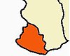
Каньякумари район

Эта статья требует дополнительных цитат для проверки . ( июль 2024 г. ) |
Каньякумари район | |
|---|---|
Anti-Clockwise from top:
Thiruvalluvar Statue, Padmanabhapuram Palace, Nagaraja Temple, Udayagiri Fort | |
Location in Tamil Nadu | |
| Coordinates: 8°19′N 77°20′E / 8.32°N 77.34°E | |
| Country | India |
| State | Tamil Nadu |
| District | Kanyakumari |
| Headquarters | Nagercoil |
| Taluks | |
| Government | |
| • District Collector | R. Alagu Meena, I.A.S[1] |
| • Superintendent of Police | E. Sundaravathanam, I.P.S |
| • District Forest Officer | M. illayaraja, I.F.S |
| • District Panchayat chairman | S. Merliant Dhas |
| Area | |
| • Total | 1,672 km2 (646 sq mi) |
| Population (2011) | |
| • Total | 1,870,374 |
| • Density | 1,100/km2 (2,900/sq mi) |
| Languages | |
| • Official | Tamil |
| • Minority | Malayalam |
| Time zone | UTC+5:30 (IST) |
| PIN | 629 xxx |
| Telephone code | 04652 for Nagercoil & 04651 for Marthandam |
| Vehicle registration | TN-74 for Nagercoil & TN-75 for Marthandam |
| Coastline | 72 kilometres (45 mi) |
| Sex ratio | M-1000/F-1014 ♂/♀ |
| Literacy | 97.6% |
| Legislature type | Elected |
| Current Member of Parliament (M.P) | Vijay Vasanth |
| Lok Sabha constituency | Kanniyakumari |
| Legislative Assembly Constituencies (6 M.L.A) |
|
| Precipitation | 2,382 millimetres (93.8 in) |
| Avg. summer temperature | 31 °C (88 °F) |
| Avg. winter temperature | 22 °C (72 °F) |
| Central location: | 8°03′N 77°15′E / 8.050°N 77.250°E |
| Website | kanniyakumari |


Район Каньякумари , официально Канньякумари , является одним из 39 районов штата Тамил Наду и южного района в материковой Индии . Он занимает второе место с точки зрения плотности населения среди районов Тамилнада . [ 2 ] Это также самый богатый район в Тамилнаде с точки зрения дохода на душу населения, [ 3 ] [ 4 ] а также возглавляет государство в индексе человеческого развития (HDI), грамотность и образование. [ 5 ] [ 6 ] Штаб -квартира округа - Нагеркол .
Район Каньякумари имеет разнообразную топографию с морем с трех сторон и горы Западных Гат, граничащих с северной стороной. За исключением небольшого участка земли к востоку от города Канньякумари , почти весь район находится между Западными Гатами и Аравийским морем - единственным районом в Тамилнаду, штате обращенным к Аравийскому морю .
Historically, Nanjinad and Edai Nadu, which comprise the present-day Kanniyakumari district, were ruled by various Tamil and Malayalam dynasties: the Cheras, the Ay/Venad/Travancore dynasty, the Pandyans, the Chozhans and the Nayaks. A few artefacts have been unearthed by archaeological excavations.[7] It was part of the princely state of Travancore during the colonial times prior to India's independence;[8] four of the eight tehsils of Thiruvananthapuram district were separated from the erstwhile Travancore Kingdom to form the new district of Kanniyakumari, and they were made the part of Madras Presidency under recommendations from the States Reorganisation Commission in 1956. The Presidency was later renamed Tamil Nadu and Kanniyakumari, today, is one of the 38 districts of Tamil Nadu state.
The district is the birthplace of Ayyavazhi. Many historical assumptions persist in the district and state, which associate sages such as Agastya, Vyasa, Tolkappiyar, Avvaiyar and Valluvar with the district.
History
[edit]
The area that comprises the current Kanniyakumari district was a part of the old Ay kingdom of the first and second Sangam ages. Following the decline of the Ay kingdoms, the area became Venad, with its capital Padmanabhapuram located North, North West of Nagercoil. The wealth of the Nanjilnadu beckoned many invaded kings including the Nayaks during the reign of Umayamma Rani. The Venad region was in anarchy before Marthanda Varma ascended the throne in 1729 CE. Under their rule anarchy was dominant in Kanniyakumari region. However, Marthanda Varma brought a sense of disorder under control by annexing the nearby territories, putting down the feudal lords and establishing the strong state of Travancore. He had also bought some portions of Kanniyakumari from the then viceroy making it the southern boundary. Under his rule, the district improved in a social context as well as economically. The famous battle of Colachel took place in the district. Later, the Maharajas of Travancore built the forts at Aramboly (Aralvaimozhy) to prevent any invasion from the Carnatic Kings. Key elements of Velu Thampi Dalawa's revolt occurred in the area and the English East India company's army under Col.
Leger broke through the fortifications and entered Travancore in 1810. In the year 1949, the area became a part of the reestablished Travancore Cochin state. The people of Agasteeswarem, Thovalai, Kalkulam and Vilavancode taluks, which formed the southern divisions of the former district of Trivandrum, were predominantly Tamil speaking people. The present Kanniyakumari district was historically part of the erstwhile Travancore State. Four Tamil-speaking taluks viz., Vilavancode, Kalkulam, Thovala and Agastheeswaram which now form the Kanniyakumari district was transferred to Madras State on 1 November 1956. The changes that were effected between the taluks and the villages as on 1 October 1956 are furnished in the fly-leaf to Table A-I.[9] An extreme agitation by Tamil speaking residents under the leadership of Marshal Nesamony took place for including Kanniyakumari within Tamil Nadu. Eventually the merger happened in 1956 based on language reorganisation of states.
Historically, Nanjilnadu (Agastheeswaram and Thovalai taluks) and Eda Nadu (Vilavancode and Kalkulam taluks) which comprises the present Kanniyakumari district. The district were ruled by various dynasties: Venad Kingdom, Travancore Kingdom, the Cheras, the Cholas, the Ays and the Nayaks. A few artefacts were unearthed by archaeological excavations in parts of the district. The district was part of the princely state of Travancore during the colonial times prior to India's independence; four of the eight tehsils of Thiruvananthapuram district were separated to form the new district of Kanniyakumari in 1956 following the demands of reunion made by the Tamil speaking majority people (about 70% of the population), who feels that their feelings were suppressed by the erstwhile Travancore Kingdom which has Malayalam-majority population. The four taluks were made the part of then Madras State under recommendations from the States Reorganisation Commission in 1956. The Madras State was later renamed Tamil Nadu in 1969 and Kanniyakumari, today, is one of the 38 districts of Tamil Nadu state.
The district is the birthplace of Ayyavazhi, the henotheistic belief initiated by Hari Gopalan Seedar, one among the 5 prime disciples of Ayya Vaikundar. The social, religious and cultural history of the 19th century Kanniyakumari district is intrinsically inter-twined with those of Ayyavazhi. Many historical assumptions persist in the district and state, which associate with sages namely Vyasa, Agastya, Tolkappiyar, Avvaiyar and Valluvar.
Geography
[edit]This section needs additional citations for verification. (July 2024) |
The district is situated between 77°15' and 77°36' east longitude and 8°03' and 8°35' north latitude.[10][11] The district has borders with Tirunelveli district in the North & North East, the Gulf of Mannar in the East, the Indian Ocean in the South, the Arabian Sea in the West and the Thiruvananthapuram District (Kerala) in the West.[12]
Kanniyakumari district has a varied topography with sea on three sides and the mountains of the Western Ghats bordering the northern side. Geologically, the landmass of the district is much younger when compared to the rest of state – faulted as late as 2.5 million years during the Miocene, after which numerous transgression, as well as regression of sea, had shaped the western coast of the district.[13]
The district can be categorised into three natural divisions:[14]
- Mountainous Terrain: Located in the northern and north-eastern portion of the district, this area includes the northern parts of Vilavancode and Kalkulam taluks. It includes several impressive hilltops and is an extension of a larger mountain range to the north.
- Fertile Sea-Coast: Stretching along the southern and South-eastern and south-western parts of the district, this coastal region is fringed with coconut trees. Although predominantly sandy, there are occasional slightly elevated patches of red cliffs.
- Valleys and Plains: Situated between the mountainous terrain and the sea-coast, this area features rolling, undulated valleys and plains interspersed with rivers and streams.
Within the northern mountainous range of the district lies the scenic sanitarium of Muthukuzhivayal. South of Peermedu, this range stands out due to its significant breadth. The rugged landscape boasts bluff ridges and conical peaks, forming a continuation of the Western Ghats that stretches all the way to the Aralvaimozhi Pass. Notably, the perfectly detached Kattadimalai stands out as a prominent rocky mass. Continuing southward, a broken rocky spur shapes into Marunthuvazh Malai, situated approximately 7 kilometres northwest of Kanyakumari. The Vellimalai in Kalkulam taluk and the Maruntuvazh malai in Agastheeswaram taluk are important isolated hills. The variations in altitude and climate across the hilly terrain of the district have led to a diverse vegetation profile, showcasing distinct representations of different land types. The highest hill within the district is Mahendragiri (1654 meters) in Thovalai taluk, situated on the border between Kanniyakumari and Tirunelveli districts. Kalmalai (900 meters), Moliyadi (700 meters) located at the head of old Kulasekaram reserved forest area and Tadakai malai (960 meters) are some of the notable hills in the district.
The mountainous terrain in the northern and eastern portions of the district contains an extensive plateau amidst elevated hilltops. While most of the hills have steep slopes, some exhibit a more gradual spread. While the area is predominantly agricultural, numerous plantations and few handloom industries thrive in this region.[15] The central area of the district, particularly Agastiswaram taluk, consists of vast plains. This includes the plains at Vellimalai, Mylaudy and Derisanamcope.
The district features an extensive 68-kilometer coastline. Predominantly regular in its configuration, the coast showcases notable projections toward the sea at locations such as Kanniyakumari, Muttam, and Erayanthurai. Additionally, there are a few minor sea ports. The ancient port of Colachel stands as the sole natural port on the west coast of Tamil Nadu while Kanyakumari serves as another minor port, primarily catering to tourists. Another minor port at is situated along the edge of Manakudi Estaury. Kanyakumari is the only district in Tamil Nadu facing the Arabian sea.[16]
Rivers
[edit]Pazhayar, the southernmost river in India, originates from the secondary range of the Western Ghats, draining Mahendragiri peak and nearby estates. Flowing through Thovalai and Agastiswaram taluks, the Pazhayar significantly supports irrigation. Its course spans approximately 37 kilometres, ultimately joining the Manakkudy Lagoon at Thamaraikulam. Notable places along the river include Boothapandi, Thalakudi, Vadasseri, Nagercoil, and Suchindram.[17]
Kodayar originates east of Valia Malai peak within the southern part of the Muthukuzhivayal plateau and flows southwest through a wild tract. Two streams—one from Motavan Pothai and the other from Thacchamala hills—contribute to this river. The Pechiparai Dam intercepts the Kodayar, creating the Pachipparai lake. With a rocky bed, steep banks, sharp curves, and frequent falls, the Kodayar remains largely untamed except for a few kilometres near its end. The Tirparappu Waterfalls along this river stands at approximately 13 meters. After covering 32 kilometres in Kalkulam and Vilavancode taluks, the Kodayar merges with the Paraliyar to form the western Tambaraparani.[18]
Originating north of Mahendragiri, the Paraliyar, another major river of the district flows southwesterly and passes out of the forest area a mile above Ponmanai[19] where it encounters the Perunchani Dam. The Left Bank Channel supplies water from the Pechipparai reservoir before reaching the weir known as Puthen dam. The ancient Pandyan dam, built in Pandiyan era, across the Paraliyar in Kalkulam taluk, along with the Pandyan Kal and related irrigation works, constitute one of the region's ancient irrigation systems. About a kilometre downstream from the Pandyan dam, the river meets the 250-year-old Puthen dam.[20] The river runs through the Kalkulam and Vilavancode taluks and covers 37 kilometres before joining the Kodayar near Thiruvattar, forming the western Thamirabarani River. It flows southwest through Kuzhithurai, Munchirai and evantually into the Thengapattanam estaury where it meets the sea.
Valliyar a minor river originates at an altitude of 950 m in the Velimalai hills[21] and passes through Kothanalloor, Kalkulam, Eraniel, Thalakulam and Manavalakurichi before joining the Arabian Sea at Kadiapattanam. Along the way, it merges with the Thuvalar, another small river originating from the Mampazhathurai hills. Mullayar another minor river flows approximately 11 kilometres through Vilavancode taluk and joins the western Tambraparani near Thikkurichi.[22]
Geology
[edit]The district features diverse topography with its northern and western regions consist of hilly terrain and forests, while the southeastern and central parts are characterised by agricultural lands. Along the southern border lies an extensive sea-shore with scattered rocky ridges, interspersed by valleys and plains. Additionally, sandy beaches and isolated boulders define the southern coastline.[23]
The Peninsular India is typically described as a highland with faulting on both sides. During the Archaean Eon, the eastern coast experienced faulting, whereas the faulting of the western coast, including the major parts of the Kanyakumari district, occurred later—approximately 25 million years ago—during the early Miocene era. Subsequent transgressions and regressions of the sea led to the formation of various sedimentary layers.
Over time, the sea receded, resulting in uplifted land masses. Evidence of this uplift includes deeply entrenched streams, waterfalls, high hanging valleys, alluvial flats, and marine sediment patches at higher elevations. Notably, shelly limestone formations in Kanyakumari further support the theory of land uplift in this area. The uplift likely occurred in stages, rejuvenating older streams. The wind gap at Mekkode resulted from river piracy, where the Paraliyar was captured by the Kodayar, possibly during the Tertiary period. The straight west coastline, uninterrupted by breaks, suggests faulting during the Pliocene epoch. Similarly, changes in the Kodayar river's course—from northward to northeast to southwest indicate faulting along its path.
Geologically, the region features two main rock groups: the Khondalites, and Charnockites while a third group, Migmatites[24] is also found. The Khondalites, composed of garnetiferous Sillimanite-Graphite Gneisses and Garnet-Biotite gneisses, dominate a significant portion of the district.[25] The Charnockites are exposed in areas between Padmanabhapuram, Aralvaimozhi, Kulasekaram, Thuckalay, and Rajakkamangalam. The distinctive occurrence of feldspathic granites across a significant portion of this region indicates that the rocks underwent intense isoclinal folding, resulting in repeated bands. These folds align in a northwest–southeast direction and may have subsequently experienced cross-folding.[26] These charnockites also occur as lenses and patches within the khondalites. Additionally, thin Pegmatite bodies and quartz veins intrude the khondalites. Tertiary-age Varkala beds appear as thin cappings south of Kaliyakkavilai near the coast.[27]
The basement rocks are covered by a sequence of soil types, including red soil, lateritic soil, clay, river alluvium, coastal alluvium, and black and red sandy soils. These soil layers have thicknesses ranging from 1 metre to 1.5 meters in most locations. The underlying geological terrain belongs to the Peninsular Gneiss. The coastal belt around Kanyakumari, Kovalam, and Vattakottai contains recent-age formations, including Calcareous sandstones, limeshells, and Kankary Limestone. Lateral deposits, including sand, zircon, rutile, ilmenite, and garnet, are commonly found along the entire sea coast of Kanyakumari.[28]
Climate
[edit]Kanyakumari district experiences a tropical climate, characterized by warm temperatures throughout the year as per the Köppen climate classification. The district generally has high temperatures year-round, with average highs ranging from 29°C to 33°C (84°F to 91°F) and average lows from 23°C to 26°C (73°F to 79°F). The Summer from March to May is typically hot, with temperatures often exceeding 34°C (93°F). The heat is more intense due to weaker winds. The region’s proximity to the Equator makes it hard to distinctly define the summer season and summers are significantly wetter than winters.[29] Winters from January to February are mild and pleasant, with temperatures rarely dropping below 19°C (66°F). The district lies at the intersection of two distinct climate zones. To the northwest, the Malabar coast, west of the Western Ghats, experiences heavy rainfall during the summer monsoon from June to September. In contrast, the southeastern coast, starting from Kanyakumari, has a semi-arid climate due to the limited impact of the summer monsoon. However, the retreating monsoon from October to December brings more rain, though its effects are somewhat reduced by the proximity of Sri Lanka.[30]
| Climate data for Kanyakumari (1991–2021, Rainy days:1999-2019) | |||||||||||||
|---|---|---|---|---|---|---|---|---|---|---|---|---|---|
| Month | Jan | Feb | Mar | Apr | May | Jun | Jul | Aug | Sep | Oct | Nov | Dec | Year |
| Mean daily maximum °C (°F) | 29.4 (84.9) |
30.5 (86.9) |
31.5 (88.7) |
31.5 (88.7) |
30.7 (87.3) |
29.1 (84.4) |
29.0 (84.2) |
29.3 (84.7) |
29.5 (85.1) |
29.0 (84.2) |
28.4 (83.1) |
28.5 (83.3) |
29.7 (85.5) |
| Daily mean °C (°F) | 26.0 (78.8) |
26.8 (80.2) |
28.0 (82.4) |
28.5 (83.3) |
28.1 (82.6) |
26.9 (80.4) |
26.5 (79.7) |
26.6 (79.9) |
26.7 (80.1) |
26.5 (79.7) |
26.1 (79.0) |
25.9 (78.6) |
26.9 (80.4) |
| Mean daily minimum °C (°F) | 23.1 (73.6) |
23.6 (74.5) |
24.9 (76.8) |
26.1 (79.0) |
26.2 (79.2) |
25.3 (77.5) |
24.8 (76.6) |
24.7 (76.5) |
24.8 (76.6) |
24.7 (76.5) |
24.2 (75.6) |
23.6 (74.5) |
24.7 (76.4) |
| Average rainfall mm (inches) | 15.0 (0.59) |
12.0 (0.47) |
27.0 (1.06) |
56.0 (2.20) |
81.0 (3.19) |
83.0 (3.27) |
42.0 (1.65) |
37.0 (1.46) |
49.0 (1.93) |
137.0 (5.39) |
183.0 (7.20) |
71.0 (2.80) |
793 (31.21) |
| Average rainy days | 2 | 2 | 3 | 7 | 9 | 11 | 7 | 6 | 7 | 12 | 13 | 6 | 85 |
| Average relative humidity (%) (at 17:30 IST) | 69 | 68 | 71 | 76 | 78 | 81 | 80 | 79 | 79 | 80 | 80 | 73 | 76 |
| Mean daily sunshine hours | 9.9 | 10.1 | 10.2 | 10.0 | 9.6 | 9.7 | 10.1 | 10.1 | 9.8 | 9.4 | 8.9 | 9.4 | 9.8 |
| Source: [31] | |||||||||||||
Unlike other districts in Tamil Nadu, it receives rainfall both from the South-west and the North-east monsoons. The region receives moderate rainfall, with the heaviest rains occurring from October to December due to the northeast monsoon which sometimes causes floods. The southwest monsoon, from June to September, also brings some rain, but its effects are less pronounced compared to other parts of India. The average rainfall of the district is 1456.8 mm per annum. From 2005 onwards the annual rainfall is estimated to be 1006 mm.[32] The driest month is February and the greatest amount of precipitation occurs in November. Humidity levels are relatively high, especially during the monsoon seasons, contributing to a humid and warm atmosphere. June has the highest relative humidity, while February has the lowest. November experiences the most rainy days, whereas January has the fewest. Overall, Kanyakumari’s climate is warm and humid, with significant rainfall during the monsoon Seasons. This tropical climate supports the region’s rich biodiversity and lush landscapes.[33]
Biodiversity
[edit]As part of the Western Ghats, one of the world's eight hottest biodiversity hotspots,[34] this district boasts a rich diversity of flora and fauna, many of which are endemic to the region.[35] The area is home to several endangered and threatened species, including the Indian Bison, Indian Rock Python, Lion-tailed Macaque, and Nilgiri Tahr. The Kanyakumari Wildlife Sanctuary, a protected area covering 457.78 km2, is situated in the northern and north-western parts of the district. It constitutes the southern section of the Agastyamalai region, bordered by Kerala's Neyyar Wildlife Sanctuary to the west and Kalakkad Mundanthurai Tiger Reserve to the east. [36] Seven rivers including the Pahrali and Thamirabarani have their origin in this forest.[37] The forests and jungles of Kanyakumari district host approximately 600 species of timber trees and 3,500 other plant species.[38] The wetlands of Suchindrum and Arumanallur alone support numerous variety of floral and faunal species across hundreds of genera.[39][40] New species are frequently being identified throughout the region.[41][42]
Forests
[edit]
Out of the total land area of 168,356.216 hectares, approximately 48,423 hectares are covered by forests. Reserved forests account for 44,799 hectares, while 3,605 hectares are unclassed forests. Additionally, there are 19 hectares of reserved lands. Most of the forests in the district are situated on slopes of hills and plateaus, benefiting from high rainfall and serving as catchment areas for numerous streams and rivers. The forests in the district are lush and virgin and is 75 million years old. The forest of this region comes under Boothapandy Mahendra-giri Reserve forest and is managed by the District Forest Officer with Headquarters at Nagercoil.[43]
The jungles host around 600 species of gigantic timber trees and 3,500 other plants, many of which hold significant economic value. Notable timber trees include teak, rosewood (blackwood), Jungle Jack, Malabar ebony, Adina cordifolia, Karumaruthu, and Vengai. Softwood varieties like Bombax ceiba and glossy-leaved jack are also abundant, along with reeds, bamboos, and sandalwood. Plantations of cardamom and tea thrive at higher elevations, while pepper, rubber, ginger, and turmeric flourish in lower areas.[19] Due to various local geological factors, the forests in the Kanyakumari division encompass 14 distinct types, based on the Champion and Seth's classification[44] ranging from lush tropical wet evergreen forests to tropical thorn forests, all within a relatively small area.[43] The region hosts a diverse array of plant species, with its natural vegetation encompassing southern thorn forests, dry deciduous forests, moist deciduous forests, semi-evergreen forests, and evergreen hill sholas interspersed with grassy downs.[45]
Dry deciduous forests:These forests, ranging from an altitude of 200 to 600 meters occour in regions like Keeriparai, Mangolamottai (lower Kodayar), Maruthaparai (Kulasekaram), Ulakkaruvi, and Kuttiyar. Tree and shrub species include Adina cordifolia, Cochlospermum religiosum, Dillenia pentagyna Hydnocarpus laurifolius, Lannea coromandelica and Terminalia chebula etc. Desmodium triangulare of the Legume family, the root parasites Aeginetia indica and pedunculata have also been recorded in the region.[46]
Moist deciduous forests:These forests occur around Kilaviaru mountains and Kalikesam river near Balamore and Vallachithode at an altitude of about 60 meters. Common trees include Acronychia pedunculata, Alstonia scholaris, Scleropyrum wallichianum, and Vateria indica. Lianas Gnetum and Derris thyrsiflora thrive in these areas. Lithophytic herbs like Begonia floccifera and Begonia malabarica are abundant around Kilaviyaru.
Tropical Wet Evergreen Forests:These forests and found in Upper Kodayar, Muthukuzhivayal, and Mahendragiri above 800 meters. These dense, impenetrable forests receive heavy monsoon rains, supporting abundant epiphytic and terrestrial orchids. Tall trees with huge trunks include Aglaia bourdillonii, Cullenia exarillata, Dimocarpus longanetc. Climbers like Embelia basaal and Smilax zeylanica are common along with epiphytes Aeschynanthus perrottetii and Hoya pauciflora.[47]
Grasslands: At elevated altitudes in Muthukuzhivayal, Mahendragiri, and Upper Kodayar, distinct grasslands thrive. Within the forested areas, each river basin—Kodayar and Pahrali—encompasses approximately 30 square miles of grasslands.[19] Common grass species in this region include Chrysopogon orientalis, Eulalia phaeothrix, Themeda trimula, and Zenkeria sebastinei. Amidst the grasses and rocky crevices, one can find beautiful orchids and Impatiens flowering alongside ferns. Additionally, other herbaceous plants such as Acrotrema arnottianum, Centratherum rangacharii, Exacum travancoricum, Leucas vestita, Linum mysorense, Hedyotis purpurascens, Heracleum candeolleanum, and Senecio ludens thrive. On dripping rocks, Utricularia purpurea and Utricularia reticulata are commonly observed.[48]
Flora
[edit]The Hills of the region harbour a unique xerophytic flora, adapted to arid conditions. At higher elevations, large grasses like Andropogon, Panicum, lemon grass, and fodder grass thrive, creating a verdant carpet. Closer to the base, shrubby forms—such as species of Phoenix, Cycas, and Inthai—find their niche. Abundant bamboo clumps (including Ochlandra) and dense cane growths (both bamboo family members) abound. Sheltered beneath the grasses, ephemeral annual herbs and herbaceous perennials emerge during favourable seasons. In the sheltered valleys, extensive paddy cultivation sustains the region. Paddy remains the staple food crop. Tapioca, the second most important food crop, thrives primarily in Kalkulam and Vilavancode taluks. Palmyrah and coconut groves dot the plains and coastal regions.[49]
The landscape is adorned with significant avenue trees, including the Banyan, jungle jack, Eugenia, Portia tree, Tamarind and more. Common edible fruits—such as mangoes, jackfruit, custard apple, various plantain varieties, pineapple, guava, and more—contribute to local livelihoods. Oranges, lime, and pomegranate also flourish. Grape cultivation occurs in specific pockets. 329 plant species have been identified across 201 sacred groves in the district. These species belong to 251 genera within 110 families. Among them, 12 are categorised as rare, endemic, and threatened. One out of every seven species found in the groves of the region are rare.[50] Notably, Alpinia galanga, Gloriosa superba, Nymphaea pubescens, Hemidesmus indicus, Kaempferia galanga, and Rauvolfia serpentina are endangered while Justicia beddomei, Leea indica, and Petiveria alliacea are considered rare. Furthermore, species such as Indigofera uniflora, Naregamia alata, Ochlandra scriptoria, and Osbeckia aspera are endemic to the sacred groves of the district.[51]

Around 60 species of medicinal plants thrive in the district. Those includes the medicinal weeds such as Abrus precatorius Abutilon indicum, Acalypha indica, Achyranthes aspera Acorus calamus Aloe vera, Alternanthera sessilis etc[52] and those found around the sacred groves include Atalantia monophylla, Atalantia racemosa, Mesua ferrea, Commelina benghalensis and Sterculia urens.[53] Showy or scented flowers—such as Kolunthu, Chempakam, henna, Ceylon Jasmine Nanthiarvattam, Asokam, and more—adorn gardens and natural spaces of the eastern areas. Several rose varieties flourish in well-tended gardens. Of the Spices, the Kanyakumari clove which accounts for 65% of India's clove production is produced around Maramalai, Karumparai and Velimalai areas above Veerapuli Reserve and Mahendragiri hills of the district.[54] Cardamom, black pepper, ginger, turmeric and other spices too thrive here. Tuberous plants like sweet potato, arrow-root, and tapioca yield edible roots. [49] The hedges in the region consist of a variety of thorny or succulent shrubs. Among them are the Screw-pine, Prickly-pear, Pineapple, Agave, and Euphorbia. Additional hedge plants include Jatropha, Pithecolobium, Casuarina, Sesbania, Erythrina, Pongu, and Lantana. Climbers, most of which have leafy growth, overgrow these hedges. Other than the xerophytic vegetation, the district also hosts hydrophytic flora. In the ponds, large associations of lotus and water lilies thrive, along with smaller Limnanthemum plants. Floating plants like Trapa bispinosa and pistia statistis cover water surfaces, often beneath the shade of big banyan trees. Submerged plants, including Ceratophyllum, Utricularia, and Chara, form a close tangle underwater. In shallow tanks and river basins, reeds flourish in marshy soil. These reeds consist of juncus, scirpus, cyperus, and typha, forming a dense palisade of leaves over the water surface. Numerous marshy plants thrive between the reeds and along the margins.[55]
The plains, up to an elevation of 200 meters, are characterised by Southern tropical thorny forests. Notable locations within this ecosystem include Anjugramam, Vattakkottai, Kanniyakumari, Marunthuvazh Malai, Colachel, and Kuzhithurai. These forests support a variety of plant life. Common trees found in the interior plains include Cassia siamea, Dichrostachys cinerea, Morinda pubescens, Thespesia populnea, Ficus bengalensis, Mangifera indica, Alstonia scholaris, Pongamia pinnata, and Calophyllum inophyllum. Shrubs and under shrubs like Crotalaria gigantea, Cassia auriculata, Vitex negundo, Crotalaria striata, and Dodonaea viscosa are abundant. Beneath the shade of these shrubs and trees, herbaceous plants such as Rhinacanthus nasutus, Asystasia gangetica and Vernonia cinerea thrive. Climbers like Pterolobium hexapetalum, Lantana camara, Cissus quadrangularis, Aganosma cymosa, Coccinia grandis, Pergularia daemia and Jasminum angustifolium are also frequently encountered in this ecosystem.[56]
The coastal areas face unique challenges due to factors like sandy soil, aridity, scanty rainfall, and strong winds. In the Foreshore sandy areas, species like Spinifex littoreus, Ipomoea pes-caprae (Sweet), Sesuvium portulacastrum, Trianthema portulacastrum, Atriplex repens, Cyperus rotundus, Mollugo cerviana, Tephrosia purpurea, T. hirta, Pedalium murex and various Portulaca species shall be found. In marshy backwater areas, Suaeda nudiflora, Salicornia brachiata, and Arthrocnemum indicum are frequently found. Backwaters near river mouths and connecting canals are often thickly fringed with Pandanus tectorius. Acrostichum aureum and Excoecaria agallocha are common in shallow waters. In the Manakudy, Thengapattanam Munchirai backwater area, Barringtonia racemosa, Ixora coccinea, and Nauclea missionis thrive. Closer to the shore, Neptunia and Hygrophila grow intermingled with Aeschynomene aspera, Ludwigia, and Ipomoea reptans. More than 100 species, spanning across 90 genera and 46 families including Adenanthera pavonina, Ficus religiosa, Psidium guajava, Ocimum tenuiflorum, Waltheria indica, Dendrobium macrostachyum and Sida acuta were recorded in the sacred groves along the south-west coast of the district.[57] The vegetation in the cape area is typically xerophytic. Acacia planifrons groves characterise this region. Within the Acacia woods, cacti, agave, and aloe grow, accompanied by a ground cover of typical xerophytic herbs, including various grasses. Moving to the inland sandy areas, these regions are characterised by xerophytic plants such as Euphorbia tirucalli, Jatropha curcas, Jatropha gossypiifolia, Cleome aspera, Chorispora tenella, Aerva lanata, Phyla nodiflora, and Zornia diphylla.[58]
Fauna
[edit]
The district is abundant in wildlife, with its hill forests showcasing a wide variety of fauna, representing most species of Southern India. The district’s fauna belongs to the Cis gangetic sub-region of the Indomalayan realm, with its hill fauna showing affinities with the Himalayas and the southwestern hill group in Sri Lanka. The district hosts ten orders of mammals. Four species of primates are found in the sholas and moist deciduous forests, including the Bonnet macaque and Toque macaque at lower altitudes, and the Lion-tailed macaque and Nilgiri Langur at elevations above 2,000 feet. The Slender Loris of the order Lemuroidea occurs in the interior forests. Situated at the tail-end of the Central Asian Flyway, the region attracts numerous migratory birds from thousands of miles away.[59]
Tigers are found around the Black Rock estate which descend to lower reaches during October and November, occasionally entering bordering villages. Panthers inhabit moist deciduous forests and often prey on domesticated animals. Bears usually reside at elevations above 3,000 feet but sometimes descend to lower levels. Wild dogs are found in the lower hills of the Muthukuzhi valley, while the Indian Grey Mongoose and Jungle Cats are common in the low country and jungles. Jackals and foxes are also common. The South Indian Hedgehog is found throughout the district. Bats are very common, with four different species present. Among squirrels, the Palm Squirrel is most commonly found in the countryside, while the Malabar Squirrel inhabits the jungles. The Indian Porcupine is found throughout the forests. Rats, mice, and hares are very common, with Black rat and Mus booduga found across the district.[60][61]
Elephants are abundant in the upper reaches of Asambu and Veerapuli reserves and are occasionally spotted around Kodayar, Perunchani and Balamore areas. Deer are seen throughout the hilly forests, with three species present: The Spotted Deer, Sambur, and the Barking Deer. The Muthukuzhi valley and the entire Asambu region are favoured by Sambur deer. The Gaur is the largest of the two bovines found in the forests, living in rock caves on hills up to an elevation of 5,000 feet. Small herds of bison frequent the sholas and grassy areas around the Muthukuzhi valley and the higher reaches of Asambu. The wild goat is usually confined to grassy slopes. Wild bears are found on the hills and jungles in herds. Additionally, aquatic dolphins and porpoises are found in river mouths and backwaters. Indian pangolins are also present in forests and surrounding valleys.[62]
The district’s forests support a rich variety of avifauna, with about 360 species recorded. Notably, 140 out of the 204 species of South Indian Passerine birds are found here. The House Crow is the most common bird, while the jungle crow is less frequently seen. Common babblers include the earthy-brown jungle babbler and the slimmer common babbler found in dry plains. Magpie-robins are usually seen near human habitations. Other common birds include the cuckoo, golden oriole and Indian robin which are frequently noted in dry areas.[63] The tailorbird and the drongo or king crow often visit the countryside. The red-vented bulbul is seen in plains where food is plentiful and at elevations of about 4,000 feet. The Iora is found in gardens and groves. Among Shrikes, the Scarlet minivet is the most common, found in woody areas and evergreen jungles. The Common myna is found on grasslands, while the common weaver bird or Baya weaver is seen in coconut groves of valleys and plains. The skylark is often heard in low country and on hills.
Three species of sunbirds — Cinnyris zeylanicus, Cinnyris asiaticus, and Loten's sunbird — are frequently found in gardens. Common woodpeckers include the golden-backed woodpecker, the Yellow-fronted Pied Woodpecker, and the Southern Rufous woodpecker. The Malabar whistling thrush, a blue-black bird, is found near hilly streams. Paradise flycatchers often visit shady groves, gardens, and deciduous jungles with bamboo-clad regions. 87 bird species from 39 families and 15 orders, including omnivores, carnivores, piscivores, herbivores, granivores, and nectarivores, such as the Eurasian Spoonbill, Brahminy Starling, Glossy Ibis, Oriental White Ibis and Spot-billed Pelican have been observed around the Swamithoppe saltpans.[64]
The House sparrow is commonly found around human habitations. Parrots are mostly seen in hilly and woody areas while various varieties of Kingfishers including White-throated kingfisher, Common kingfisher and Pied kingfisher are found beside inundated paddy fields, ponds, kutcha wells and sandy seashores.[65] Bee-eaters are very common. The Indian blue rock pigeons are seen all over the plains. Among game birds, the Jungle fowl is common around the Asambu forests in the Azhagiapandiapuram range. Francolinus is often seen in thorny scrubby areas. Two main varieties of owls are the Spotted owlet and the Barn owl, which occasionally stray into the countryside and perch on house tops. Other varieties include the Brown fish owl and the Indian great horned owl. Two important species of kites in this district are the pariah kite and the Brahminy kite.[66][67]
Among the birds of prey, the White-rumped vulture and the White scavenger vulture are prominent. Water birds are common along coastal backwaters, inundated paddy fields, and tanks. The White-breasted waterhen is often seen in marshy areas overgrown with reeds and bushes, and on the margins of ponds. Storks and Coots are frequently found in inundated paddy fields, tanks, ponds, and rivers. Comb ducks are observed at Suchindram and Theroor wetlands[68] while four other species of ducks are common in the area. The Indian pond heron is abundant in paddy fields and ponds. Flamingos including Greater flamingos could be spotted across the Rajakkamangalam and Manakudi estuary throughout the year.[69]
The region’s reptiles include crocodiles, tortoises, turtles, lizards, and snakes. There are two species of crocodiles, nine species of chelonians, 33 of lizards, and 74 of snakes. The King Cobra frequents rivers and streams in shola forests. The Viper and the Indian cobra are common, often found in tree hollows and dilapidated houses. Rat snakes are frequently seen and Pythons are found in dry sandy areas. Among amphibians, 34 species of frogs are present, including Rana aurantiaca, Ixalus travancoricus, and Ferguson's toad. The Indian Leaping frog is found around Kiripparai areas.[70]
Прибрежная зона известна своими богатыми разнообразием рыб, с идентифицированным почти 370 видов. Китовые акулы [71] and Saw fish[72] изобилуют в морях, а также плода , креветки , креветки и крабы . Рок -устрицы образуют плотные колонии в Ковалламе , а небольшой вид осьминога встречается в скалах на Кейп -Коморин. Священный Chank находится здесь в больших количествах. В Кейп -Коморин два вида верхних оболочек Трош -Эдиатус и Трош Костатус являются изобилиями. Различные ядовитые насекомые, в том числе скорпионы и пауки , встречаются в округе. Клещи рода Ixodes обычно встречаются на лугах. Среди членистоногих , насекомых, таких как ранатра , цибистер , уходы , продуктора , гидрометра , тараканы , листовые насекомые , кузнечики и сверчки . [ 73 ] [ 74 ]
Политика
[ редактировать ]| Округ | Нет. | Избирательный округ | Имя | Вечеринка | Альянс | Замечания | ||
|---|---|---|---|---|---|---|---|---|
| Каньякумари | 229 | Panniyamari | Н. Талавай Сундарам | Все Индия Анна Дравида Маннетра Кажагам | Никто | |||
| 230 | Нагеркол | Мистер Ганди | Бхаратия Джаната Партия | В | ||||
| 231 | Колли | Принц JG | Индийский национальный конгресс | Спа -салон | ||||
| 232 | Падманабхапурам | Мано Тангарадж | ДРАВИДА МУННЕТРА Казагам | Спа -салон | ||||
| 233 | Вилаванкод | С. Виджаядхарани | Индийский национальный конгресс | Спа -салон | Подал в отставку 24 февраля 2024 года | |||
| Тарахай Катберт | Индийский национальный конгресс | Спа -салон | ||||||
| 234 | Чимония | С. Раджеш Кумар | Индийский национальный конгресс | Спа -салон | ||||
Места интереса
[ редактировать ]Тируваллувар Статуя
[ редактировать ]
Статуя Тируваллувара , или статуя Валлувара , представляет собой 41-метровую каменную скульптуру тамильского поэта и философа Валлувара , автор « Тируккураль» , древней тамильской работы над дхармой и морали . Он расположен на небольшом острове недалеко от города Канниякумари на самой южной точке Индийского полуострова на побережье Коромандел , где два моря ( Бенгальский залив и Аравийское море ) и океан ( Индийский океан встречаются ). Статуя была скульпирована индийским скульптором В. Ганапати Стхапати , который также создал Ирайван -храм и был представлен в день тысячелетия 1 января 2000 года тогдашним главным министром М. Карунанидхи . В настоящее время это 25 -я самая высокая статуя в Индии .
Thirparappu Waterfalls
[ редактировать ]
Водяные водопроводы ThirParp Он также известен как «Courtallam of Kaniyakumari» Храм Махадевар - лучшее время для водных флаг. Водяные флаг в 7 км (4,3 мили) Куласекарама от На самом деле водяки ровно в 34 км от центра города, Нагеркол.
Манипулирован
[ редактировать ]Manimedai расположен в центральной части Нагеркол . Manimedai буквально означает высокие часы. Это символ города Нагеркол. Часы помещаются в высокий уровень часов, поэтому место становится манимедами. Строительство часового датчика началось в 1892 году в период Траванкора Махараджа. После строительства он был открыт его Высочеством Шри Мулам Тирунал Варма, король Траванкора. Часы, помещенные в датчик, были одарены английским миссионерам в Нагеркол.
Матур акведук
[ редактировать ]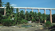
Авведук Матура был построен для прохождения водой, обрабатывающейся между двумя горами. Математический акведук был построен между поздним и самым важным в мире. Акведук был построен бывшим детским министром Тамилнада Перунталайвара Тхиру Камараджар. Матихурский акведук был лучшим в конце 1990 -х годов. Акведук имеет длину 1240 футов (380 м), высотой 101 фут (31 м) с 28 Gant столбами. Он находится в 3 км (1,9 мили) от Тируваттара и 26 км от Нагеркоила.
Падманабхапурам Дворец
[ редактировать ]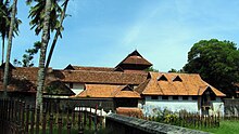
До веков дома, в которых есть все объекты, известны как дворцы. Правители штатов, короли проживают в таких дворцах. Padmanabhapuram Palace когда -то был официальной резиденцией Travancore Kings. Padmanabhapuram Palace был построен в архитектуре в стиле Кералы с лесами. Дворец был построен в 18 -м веке королем Траванкора Тиру Анизэмом Тируналом Мартандой Вармой . Дворец был расположен в 6,5 акрах в 186 акрах в форте. Дворец находится под контролем правительства Кералы . Дворец расположен всего в 2 км от Тукалай .
Форт Удаягири
[ редактировать ]Форт Удайгири находился всего в 10 км от Парватипурама . Форт был расположен в 22½ гектарах в месте под названием Puliyoorkurichi. Форт поддерживается Министерством лесов, правительство Тамилнада.
Трясогузка
[ редактировать ]
Слово « Vattakkottai » означает Circle Fort и является круговым. Форт был построен вдоль побережья на восточном побережье. Форт был расположен в 3½ акрах с составными камнями, построенными на 25 метров в высоту и построен главным начальником армии Траванкора Диланай. Форт находится под контролем археологического департамента, правительство Индии. Он расположен в 6 км к северу от Канниякумари и в 2 км к югу от Анжуграмама .
Вивекананда Рок
[ редактировать ]
Vivekananda Rock Memorial - это памятник в Ваватурае в районе Канньякумари. Он расположен всего в 500 метрах к востоку на материке Ваватурай . Скала была построена в 1970 году в честь Свами Вивекананды, который, как говорят, достиг просветления на скале. Вивекананд был учеником Свами Рамакришны Парамаханса . [ 77 ] Согласно местным легендам, богиня Кумари исполнила тапас в преданности Господа Шивы в этих камнях. Скалы окружены лаковым морем .
Храм Читарал Джайн Рок
[ редактировать ]
Он известен тем, кто вырезан в рок. Hill Rock в Читарале имеет пещеру, содержащую скульптуры, вырезанные в скале, и сопутствующие божества, вырезанные внутри и снаружи, начиная с 9-го века нашей эры королем Махендры Варман I. [ 78 ]
Административные подразделения
[ редактировать ]В административных целях район включает в себя шесть талуков и девять блоков. В районе есть муниципальная корпорация, которая является нагерколом. Есть также четыре муниципалитета и 51 городские панчаяты. [ 79 ]
На более низких уровнях администрации есть 95 деревенских панчаятов . [ 80 ]
Подразделения доходов и талуки
[ редактировать ]Отдел доходов Падманабхапурама
Муниципальная корпорация
[ редактировать ]Муниципалитеты
[ редактировать ]Городские панчаяты
[ редактировать ]- Каньякумари
- Agasteeswaram
- Ажагапапурам
- Коттарам
- Марнгу
- Милауди
- Южный Тамаракулам
- Сучиндрам
- Терхор
- Анжуграмам
- Аралвайможи
- Ажагиапандиапурам
- Бутапанди
- Тхажакуди
- Путалам
- Ганапатипурам
- Thingalnagar
- Эраниэль
- Каллукуттам
- Мандайкаду
- Манавалакуричи
- Neyyoor
- Ритапурам
- Велималай
- Каппиярай
- Kothanalloor
- Кумарапурам
- Тирувитакод
- Госпог
- Valvaithankoshtam
- Вилавур
- Villukuri
- Аттестат
- Куласекарам
- Понманай
- Тируваттар
- Тирпараппу
- Веркихамби
- Карунгал
- Кежхкулам
- Чимония
- Наллур
- Палапаллам
- Unnamalaikadai
- Пудинг
- Аруманай
- Эдайкоду
- Кадаял
- Калияккавилай
- Пасто
- Pazhugal
Предлагаемые муниципалитеты
[ редактировать ]Предлагаемые городские панчаяты
[ редактировать ]Панчаяты профсоюзы / блоки
[ редактировать ]- Agastheeswaram
- Раджаккамангалам
- Приспособление
- Курунтанкод
- Thuckalay
- Тируваттар
- Чимония
- Жевать
- Мелпур
Крупные города
[ редактировать ]Основные города района включают:
- Acastheem Taluk: Nagercoin , Kanniyakumari , Anjugramam , Mylaudy , Agastheeshwaram , Sudindram , Rajakkaamangalam ,
- Thovalai Taluk: Boothapandi , Thovalai , Azhagiapandiapuram , Aralvaimozhy
- Калкулам Талук: Падманабхапурам , Такала , Колахель , Калкулам , Тирувитхамкод , Эраниэль , Курунтхакоде , Тингалнагар
- Тируваттар Талук: Тируваттар , Куласекарам
- Killiyur Taluk: Killiyoor , Karungal
- Vilavancode Taluk: Kuzhithurai , Marthandam , Vilavancode , Kaliyakkavilai , Munchirai , Kollemcode , Manjalumoodu , Arumanai , Melpuram
Демография
[ редактировать ]| Год | Поп | ±% pa |
|---|---|---|
| 1901 | 359,248 | — |
| 1911 | 422,260 | +1.63% |
| 1921 | 494,125 | +1.58% |
| 1931 | 581,851 | +1.65% |
| 1941 | 676,975 | +1.53% |
| 1951 | 826,380 | +2.01% |
| 1961 | 996,915 | +1.89% |
| 1971 | 1,222,549 | +2.06% |
| 1981 | 1,423,399 | +1.53% |
| 1991 | 1,600,349 | +1.18% |
| 2001 | 1,676,034 | +0.46% |
| 2011 | 1,870,374 | +1.10% |
| источник: [ 81 ] | ||
Согласно переписи 2011 года , в районе Канниякумари население составило 1 870 374, а пола-1019 женщин на каждые 1000 мужчин, что значительно выше среднего по стране-929. [ 82 ] В общей сложности 182 350 лет было до шести лет, составляющих 92 835 мужчин и 89 515 женщин. Запланированные касты и запланированные племена составляли 3,97% и 0,39% населения соответственно. В округе было 483 539 домохозяйств. В общей сложности было 679 620 рабочих, в которых было 12 229 культиваторов, 51 350 основных сельскохозяйственных рабочих, 21 078 в домохозяйственных промышленности, 468 001 других работников, 126 962 маргинальных работников, 3,381 маргинальные культиваторы, 21 517 маргинальных работников, 14,711 маргинальных работников и 87,517 маргинальных работников, 14,711 маргинальных работников и 87,517 маргинальных работников, 14,711 маргинальных работников и 87 37 37 3 77 37 37 37 37 37 37 3 77 37 37 37 37 37 37 37 3 77 37 3 77 37 3 77 37 3 77 37 3 77 37 3 77 37 3 77 3 77 3 77 37 3 77 37 37 37 лет. Полем [ 82 ]
Средний уровень грамотности в Канниякумари в 2011 году составил 91,75 по сравнению с 87,55 в 2001 году. Если все смотрит на гендерные и женские грамотность составила 93,65 и 89,90 соответственно. Для переписи 2001 года те же фигуры составляли 90,37 и 84,79 в районе Канниякумари. Общее количество литератов в районе Канньякумари составляло 1 548 738, из которых мужчины и женщины были 780 541 и 768 197 соответственно. В 2001 году в округе Канньякумари в округе было 1,308,322.
Языки
[ редактировать ]Тамил является наиболее широко разговорным языком в районе Канньякумари, хотя существует значительное меньшинство (5,76%) малаяламских носителей ( малаялис ), живущих в основном вдоль границы Кералы. [ 83 ] Район Канниякумари имеет тамильский диалект, который отличается от другой части Тамилнада , поскольку он оказывает небольшое влияние на малаялам. [ 84 ] Английский может быть понят двумя третями населения района. [ 85 ]
Городское население
[ редактировать ]Из общего численности канниякумари на переписи 2011 года 82,33 процента жизни в городских регионах округа. В общей сложности 1 539 802 человек живут в городских районах, в которых мужчины составляют 761 407, а женщины - 778 395. Соотношение полов в городском регионе Канниякумари составляет 1022 в соответствии с данными переписи 2011 года. Точно так же соотношение секса детей в районе Канниякумари было 966 в переписи 2011 года. Детское население (0–6) в городском регионе составило 148 570 из которых мужчины и женщины составляли 75 573 и 72 997.
Эта детская популяция в районе Канньякумари составляет 9,93% от общего городского населения. Средний уровень грамотности в районе Канниякумари в соответствии с переписью 2011 года составляет 91,96%, из которых мужчины и женщины составляют 93,92% и 90,06% литераты соответственно. В фактическом числе 1 279 358 человек в городском регионе, из которых мужчины и женщины составляют 644 109 и 635 249 соответственно.
Сельское население
[ редактировать ]По словам переписи 2011 года, 17,67% населения Канниякумари живет в сельских районах деревень. Общее количество населения Канниякумари, проживающее в сельской местности, составляет 330 572 из которых мужчины и женщины составляют 164 938 и 165 634 соответственно. В сельских районах района Канньякумари соотношение полового составляет 1004 женщин на 1000 мужчин. Если рассмотрены данные о соотношении пола детей в районе Канниякумари, цифра составляет 957 девочек на 1000 мальчиков. Детское население в возрасте от 0 до 6 лет составляет 33 780 в сельских районах, в которых мужчины было 17 262, а женщинам-16 518.
Детское население составляет 10,47% от общего сельского населения района Канниякумари. Уровень грамотности в сельских районах района Канньякумари составляет 90,76% в соответствии с данными переписи 2011. Гендерные мудрые, мужская и женская грамотность составила 92,39 и 89,16 процента соответственно. В общей сложности 269 380 человек были грамотными из которых мужчины и женщины были 136 432 и 132 948 соответственно.
Религия
[ редактировать ]Согласно переписи 2011 года, общая численность населения округа составляет 1 870 374, среди которых 909 872 (48,7%) - индусы, 876 299 (46,9%) - христиане, 78 590 (4,2%) - мусульмане, 438 (0,02%) - буддисты, 160 (0,01%) - 438 (0,02%), 160 (0,01%) - 438 (0,02%), 160 (0,01%), 438 (0,02%), 160 (0,01%), 438 (0,02%), 160 (0,01%), 438 (0,02%), 1600 (0,2%), 438 (0,02%), 1600 (0,2%), 438 (0,02%). %) являются сикхами, 156 (0,01%) - джайны, 10 (0,001%) - другие, а 4849 (0,26%) - «не указаны». [ 86 ] Западные талуки района-это христианское большинство, в то время как восточные талуки-индуистское большинство. Некоторые из индуистских популяций следует за Айяважи. Протестанты и католики присутствуют в христианском населении, а протестанты в основном из общины Надар и католиков от рыбаков . Некоторые сирийские христиане также живут здесь.
Фестивали
[ редактировать ]
Фестиваль Мандайкаду
[ редактировать ]Фестиваль Мандайкаду отмечается в марте людьми округа и людьми в Керале. Традиционно участники будут петь, ходя, в то время как другие предоставили бы им маслом, молоком, водой, джаггери и кофе. Фестиваль, который отмечается в течение десяти дней, позже стал социальной функцией, особенно в воскресенье.
Фестиваль Коллемкода
[ редактировать ]Фестиваль Kollemcode Takentam - это еще один известный фестиваль, отмеченный жителями района, а также людьми из близлежащего района Тируванантапурам штата Керала. Он отмечается в течение 10 дней в марте/апреле, когда знаменитый ребенок Takeam, который проходил на 10 -й день, соответствующий Мине Бхарани в соответствии с календарем малаялам.
Фестиваль шествия «Эзонналат» или «Процессия слонов» в Алаппакоде Сри Эзваракала Бедхатан Храм, расположенный в Андукоде, также является еще одним крупным фестивалем округа. Это крупнейший фестиваль слонов в Тамилнаде, который часто считается Тамил Наду Триссером Паймамом.
Празднование дня рождения Айя
[ редактировать ]Айяважи отмечается широко . [ 87 ] [ 88 ] отмечается Тирунал Kodiyettru в религиозной штаб -квартире Swamithope Pathi и привлекает более крупные толпы [ 89 ] от Тамилнада и по всей Индии. [ 90 ] [ 91 ] [ 92 ] Оним также отмечается во многих местах в районе Канниякумари, особенно в западной части района.
Фестиваль храмового автомобиля SupeEendrum
[ редактировать ]
Религиозное значение храма Танумалая проистекает из того факта, что основная статуя линга представляет Шиву (Стхану), Вишну (Маал) и Брахму (Аян) (а также дает храму его имя). Представление трех центральных богов индуизма в одном линге делает его уникальным в Индии. 10-дневный автомобильный фестиваль , отмеченный в этом храме в период с декабря по январь каждого года, привлекает толпы тысяч людей. Следуют специальные практики поклонения, и фестивальные изображения Стханумалаян, Арам Валарта Наяги и Винаягар снимаются в храмовой машине вокруг улиц храма. Другой фестиваль, известный как Teppam, отмечается в период с апреля по май каждый год. Санскритская работа, которую Sucindrastalamahatmya дает полноценным легендарным сообщением о происхождении и развитии этого храма. [ 93 ]
Конусы, Св. Фестиваль храма Фрэнсиса Ксавьера
[ редактировать ]Церковные записи указывают на то, что церковь Святого Ксавье была построена в 1600 году. В 1865 году храм Марии был отремонтирован и расширен. В 1930 году церковь была поднята до статуса собора . Ежегодный фестиваль отмечается в течение ноября - декабрь, продолжительностью 10 дней. Люди из разных мест и рядом с штатом Керала также присоединяются во время фестиваля. Во время фестиваля другие религиозные люди также собираются вместе. и помогая организовать фестиваль с помощью благоприятных способов.
Канья Кумари, Фестиваль храма Багавати Амман
[ редактировать ]- Фестиваль Chitra pournima: в день полнолуния в мае
- Фестиваль Наваратри : 9 -дневный фестиваль в (сентябрь -октябрь). Музыкальные артисты получают возможность предложить свои художественные навыки богине, выступая в мандапаме Наваратри .
- Фестиваль Вайсаха: 10-дневный фестиваль в мае-Джуне, кульминацией которого является Тони Эжнунеллату в мае-июне. Во время этого фестиваля Деви будет приниматься в процессии как утром, так и вечером, во время Аараату, восточная дверь открыта. На девятый день Тони Эзхунеллату происходит . Деви будет взять вокруг воды на западной части в лодке. [ 94 ]
- Фестиваль Калабхэма: Идол смазан в сандаловой пасте в последнюю пятницу месяца Каркидаки или Аади в июле - август. [ 95 ]
Onam festival
[ редактировать ]Онам - это ежегодный фестиваль урожая и культурный фестиваль, связанный с индуизмом , который отмечается в основном жители Кералы . Народ района Каньякумари также празднует этот фестиваль (ранее округ Каньякумари был частью Кералы). Дата празднования Онама основана на Панчангаме и падает на 22 -й Накшатра Тирувонам в месяце Чингама малаяламского календаря , который в григорианском календаре падает в период с августа по сентябрь. [ 96 ] [ 97 ]
Kuzhithurai Vavubali Выставка
[ редактировать ]Ежегодный церемония «Каркида Ваву Бали» (Шрадхэм для предков, проводимые во время церемонии Махалайи Амавасай), которая проводится здесь в июле/август (месяц малаялам Каркидакам). Наряду с религиозной церемонией в течение этого времени знаменитая ежегодная выставочная ярмарка - Vavubali Mela / выставка - была основана Шри. TC Kesava Pillai, MLC из Kuzhithurai в 1900 -х годах. Сегодня это продолжается муниципалитетом города Кужитурай . [ 98 ] Люди из разных мест и рядом с штатом Керала также присоединяются во время фестиваля. Во время фестиваля другие религиозные люди также собираются вместе.
Marungoor Soora Samharam и Mylaudy Arattu Fest
[ редактировать ]Храм Subramania Swamy, который расположен на вершине небольшого холма, стоит места для посещения. Эта область храма называется Кумарапурам Топпур, Марунгур . Из -за названия Кумарана (Субрамания Свами). Шашти и Сурасамхарам - знаменитые фестивали в этом храме. Знаменитый фестиваль Kandhashashti Kavasam здесь очень популярен и отмечается как крупный фестиваль. Спустя 5 дней спустя Subramania Swamy приехала в Милоуди на серебряной конной машине и ванной в реке Милоуди и Абишекам с 17 продуктами. Каждый год он отмечался только в районе Каньякумари после 5 дней фестиваля Сурасамхарама . Люди из разных мест присоединяются во время фестиваля. Во время фестиваля другие религиозные люди также собираются вместе.
Транспорт и автомагистрали
[ редактировать ]Дороги
[ редактировать ]Есть две основные дороги национальных автомагистралей (NH), происходящие из города Канньякумари. Одним из них является национальное шоссе 44, которое соединяет Канниякумари со Сринагаром из Джамму и Кашмира . NH 44 соединяет Северную Индию с Южной Индией. Дорога проходит через Мадурай , Хосур , Бенгалуру , Хайдарабад , Нагпур , Джханси , Дели и Джаландхар . Он покрывает 3745 километров. Другое - это Национальное шоссе 66, которое соединяет Канниякумари с Панвелом (в 38 км от Мумбаи ) в Махараштре. NH 66 грубо работает на север -юг параллельно Западным Гатам. Он проходит через Тируванантапурам , Кочи , Кожикоде , Мангалуру , Удупи , Маргоа и Ратнагири . Нагеркол, окружная столица хорошо связана с остальной частью Тамилнада .
SETC Автобусы
[ редактировать ]транспортная корпорация State Express Transport Corporation прямыми Ченнаи , Отакамунд , Коимбаторе , Тируваннамалаи , Чидамбарам , Тиручирам , Кодайканал автобусами и ) управляет Правительственная SETC Калпакам , Веланканни ( в . Он также управляет прямыми автобусами в Бангалору , Пондичерри и Тирупати . Некоторые автобусные услуги до вышеупомянутых направлений происходят из Канниякумари , Колахель , Мартхандама , Куласекарама , Калияккавилай и Тирувантхапурама .
Автобусы TNSTC
[ редактировать ]Другой правительственный транспортный орган, известный как транспортная корпорация (TNSTC), управляет прямыми автобусами Тамилнада государственная из Ченнаи , Тируппур , Периякулам , Кодайканал , Рамсварам , Тиручираппалли , Диндигул , Танджавур , I. Некоторые завершающих , станций Палани , Караикуди , Бодинайаккан Кумили , and - это Большинство из этих автобусов начинают свое путешествие из Нагеркола автобусы начинаются с Канниякумари , Мартхандама , и Хел. Коласекарам Некоторые Калияккавилай . TNSTC также эксплуатирует частые автобусные услуги в Мадурае , Тирунелвели , Тиручендуре , Тутикорин и Тирувантхапурам .
Автобусы KSRTC
[ редактировать ]Правительство Кералы эксплуатирующее KSRTC между Кералой и Тамилнаду из Тируванантапурама в Нагеркол , автобусы И автобус KSRTC между Холлом помещает Харипад , Тируванантхапурам , Нагеркол , Милауди , Атанкарай Палливасал (Тирунелвели Дист).
Железные дороги
[ редактировать ]расположена железнодорожная станция В Канниякумари , где заканчиваются поезда. Vivek Express, начиная с Канниякумари, является самым продолжительным поездом в Индии. [ 99 ] Он соединяет Канниакумари с Дибругархом , в Ассаме . Железнодорожный вокзал Nagercoil Junction является основной железнодорожной станцией округа, расположенной недалеко от Коттара, также широко известной как железнодорожный вокзал Коттар. В Нагеркоиле есть еще одна железнодорожная станция, известная как железнодорожная станция Нагеркол Таун . Существует железнодорожное соединение от Нагереркал, окружной столицы, до большинства частей страны с ежедневными поездами, бегущими в Мумбаи , Ченнаи , Бенгалуру , Гурувайур, Тируванантхапурам , Коимбаторе , Мадурай Мангалуру, Тамбурам и еженедельные поезда в Нью -Дели , Тричи , Тричи Тричи , , Мангалуру , Тамбурам и еженедельные поезда в Нью -Дели , Мангалуру, Тамбурам и еженедельные поезда в Нью -Дели , , Тричи, Мангалуру, Тамбурам Калькутта , Гуджарат , Хайдарабад , Пондичерри , Биласпур , Рамсварам , Северо -Восточная Индия и Джамму и Кашмир . Другими станциями в районе Каньякумари являются железнодорожный вокзал Эраниэль , Паллияди железнодорожный вокзал , железнодорожный вокзал Кужитурай и Кужхитурай железнодорожный вокзал . Пассажирские поезда соединяют Нагереркул с Тируванантапурамом , Колламом , Пуналуром , Коттамеймом , Тирунелвели , Мадураем и Коимбаторе .
Дыхательные пути
[ редактировать ]Ближайший международный аэропорт - международный аэропорт Тривандрум , который находится в 76 км от Канниякумари. Министерство гражданской авиации планирует построить аэропорт недалеко от Свамитоппу в районе Канньякумари, поскольку инициатива привлекает международных туристов в округ. [ 100 ]
Образование
[ редактировать ]Согласно переписи 2011 года , Каньякумари имеет уровень грамотности 91,7%по сравнению с уровнем грамотности в Тамилнаде 80,1%. Район зафиксировал самый высокий уровень грамотности мужчин в 92,4%, а уровень грамотности женщин - 89,2% в сельских районах, а также самый высокий уровень грамотности женщин в 90,1% в городских районах. [ 101 ]
Район является домом для многих устоявшихся учреждений, таких как колледжи, как Скотт Христианский колледж (Est. 1809), Южный Траванкоре Индуистский колледж (Est. 1952), колледж Святого Креста (Est. 1965), Женский христианский колледж , Колледж Сиванти Адитанар ( Est. 1984) и такие школы, как Высшая средняя школа Ringletaube (Est. 1809), Высшая средняя школа Скотта Кристиана (Est. 1819), школа Duthie Girls (Est. 1819), высшая средняя школа монастыря Святого Иосифа (Est. 1910) , Кармель Высшая средняя школа (Est. 1922), Высшая средняя школа правительства SLB (Est. 1924), Высшая средняя школа SMRV (Est. 1919).
Смотрите также
[ редактировать ]Ссылки
[ редактировать ]- ^ «Район Канниякумари» . www.tn.gov.in. Получено 21 июля 2024 года .
- ^ Кумари второй самый урбанизированный район Т.Н. - Южная Индия - Тамил Наду - Ибнлив
- ^ "Это 5 самых богатых районов Тамилнада .
- ^ «Государственный доход Глава 2.1 императивы роста» (PDF) . Правительство Тамилнада .
- ^ Рамакришнан, Т. (17 мая 2017 г.). «Канниякумари возглавляет рейтинги HDI» . Индус .
- ^ «Уровень грамотности TN на новом высоте» . 22 марта 2012 года.
- ^ «Раскопки Киелади - откровение, которое переписывает историю Тамилнада - Тамилнаду туризма» . 22 октября 2019 года . Получено 7 сентября 2020 года .
- ^ «Детали округов | Правительственный портал Тамилнада» . tn.gov.in. Получено 7 сентября 2020 года .
- ^ «Перепись 1961 года штат Керала» (PDF) . lsi.gov.in. п. 14. Архивировано из оригинала (PDF) 24 июня 2021 года.
- ^ Министерство окружающей среды и лесов. «Район Каньякумари» (PDF) .
- ^ Карты Индии. «Районная карта Каньякумари» . www.mapsofindia.com .
- ^ «Профиль района - 2017» (PDF) . Kanniyakumari.nic.in .
- ^ Отчет департамента шахт. «Отчет о окружном обследовании по району каменного камня Канньякумари» (PDF) . tnmines.tn.gov.in .
- ^ Центр Envis Speak. "PDF) (PDF ) tnenvis.nic.in
- ^ «Канниякумари | храмовый город, прибрежная красота, туристическое направление | Британская» . www.britannica.com . 9 июля 2024 года . Получено 12 июля 2024 года .
- ^ «Топографическая карта района Каньякумари, высота, местность» . Топографические карты . Получено 12 июля 2024 года .
- ^ «Пажаяр - Индия WRIS Wiki» . IndiaWris.gov.in . Получено 12 июля 2024 года .
- ^ «Многоцелевые проекты River Valley в районе Каньякумари | rjisacjournal.com» . 18 октября 2015 года . Получено 12 июля 2024 года .
- ^ Jump up to: а беременный в TF Bourdillon (1892). Траванкоре леса .
- ^ «Физические и химические характеристики реки Паралиир в районе Каньякумари, Тамил Наду, Индия» . Журнал исследований в области биологии . 7 апреля 2021 года.
- ^ Перумал, С. Бхагавати; Thamarai, P. «Литологические исследования и типы почв вдоль прибрежной зоны Каньякумари к прибрежному поясу Колахель» (PDF) . Природная среда и технология загрязнения . ISSN 0972-6268 .
- ^ "Каньякумари | Твид" . twadboard.tn.gov.in . Получено 12 июля 2024 года .
- ^ Гопакришнан М. (13 января 1995 г.). Журналисты Индии - район Канакури Ченнаи: Комиссар по архивам и историческим исследованиям, правительство Тамилнада. П. 11
- ^ Департамент геологии и добычи полезных ископаемых, правительство Тамилнада. «Отчет о окружном обследовании по району Каня Канья Кумари» (PDF) . tnmines.tn.gov.in .
- ^ «Ресурсы подземных вод - район Каньякумари» (PDF) . www.nwm.gov.in.
- ^ «Bibliomed.org - полный текст просмотра статьи» . www.bibliomed.org . Получено 19 июля 2024 года .
- ^ Национальная водная миссия. «Ресурсы грунтовых вод Каньякумари» (PDF) . NWM.gov.in.
- ^ Перумал, доктор С. Бхагавати; Субраманян, доктор против Баладжи; Nigun.T, Krithik; Приянка. Hegde.g, Geethesh; R, Rameswan (13 марта 2021 г.). «Изучение геологических параметров вдоль прибрежного района Аравийского моря, Каньякумари в Колахель, Южный Тамилнаду, Индия» . Начальное образование онлайн . 20 (1): 4888-4901. ISN 1305-3515 .
- ^ en.climate-data.org https://en.climate-data.org/asia/india/tamil-nadu/kanniyakumari-34132/ . Получено 19 сентября 2024 года .
{{cite web}}: Отсутствует или пусто|title=( помощь ) - ^ «Каньякумари климат: погода за месяцем, температура, дождь - климат для путешествий» . www.climatestotravel.com . Получено 19 сентября 2024 года .
- ^ «Климат Канниякумари: средняя температура по месяцу, температура воды Канниякумари» . en.climate-data.org . Получено 19 сентября 2024 года .
- ^ Envis Center. "PDF) (PDF ) tnenvis.nic.in
- ^ WMO. «Мировая информационная служба погоды» . Мировая информационная служба погоды . Получено 19 сентября 2024 года .
- ^ Центр, Всемирное наследие ЮНЕСКО. "Западные Гаты" . Центр Всемирного наследия ЮНЕСКО . Получено 29 июля 2024 года .
- ^ С. Сукумаран; С. Джива; Dsraj; Д. Канан. «Флористическое разнообразие, статус сохранения и экономическая ценность миниатюрных священных рощи в районе Каньякумари, Тамил Наду, Южная полуостровная Индия» (PDF) . Tüb ‹Tak Academic Journals . 32
- ^ «Структура растительного сообщества в тропических лиственных лесах заповедника дикой природы Каньякумари, Индия» . Biodiversitas . 18 (1): 392.
- ^ "Мировое святилище " Till Nadu Tourism.gov.in
- ^ М. Гопакришнан (13 января 1995 г.). Журналисты Индии - район Канакури Ченнаи: Комиссар по архивам и историческим исследованиям, правительство Тамилнада. П. 23
- ^ Bantant S & Augustus Arul. ) (PDF . Международный журнал журнал исследований 7 (1): 698–7
- ^ «Миссия водно -болотных угодий Тамилнада» . www.tnswa.org . Получено 29 июля 2024 года .
- ^ Манодж, Эм (17 ноября 2023 г.). «Ученые BSI открывают два новых вида растений на западных Гатах» . Индус . ISSN 0971-751X . Получено 29 июля 2024 года .
- ^ Ниже, сури; Mohapin, Praatyush P.; Салан, Амирха; Дас, Сандип; Гауэр, Дэвид Дж. (15 апреля 2021 г.). "Змеи . Вертеврированная зоология . 71 : 219–2 doi : 10.3897/v.71.e63986 . ISSN 2625-8
- ^ Jump up to: а беременный «Район Каньякумари» (PDF) . tnenvis.nic.in .
- ^ «Структура растительного сообщества в тропических лиственных лесах заповедника дикой природы Каньякумари, Индия» . Biodiversitas . 18 (1): 393.
- ^ "Мировое святилище " tammilnadutourism.gov.in
- ^ М. Гопакришнан (13 января 1995 г.). Журналисты Индии - район Канакури Ченнаи: Комиссар по архивам и историческим исследованиям, правительство Тамилнада. П. 25
- ^ М. Гопакришнан (13 января 1995 г.). Журналисты Индии - район Канакури Ченнаи: Комиссар по архивам и историческим исследованиям, правительство Тамилнада. Стр. 25–2
- ^ М. Гопакришнан (13 января 1995 г.). Журналисты Индии - район Канакури Ченнаи: Комиссар по архивам и историческим исследованиям, правительство Тамилнада. П. 26
- ^ Jump up to: а беременный Гопакришнан М. (13 января 1995 г.). Журналисты Индии - район Канакури Ченнаи: Комиссар по архивам и историческим исследованиям, правительство Тамилнада. П. 16
- ^ Selvamony Sukumaran, Solomon Jeeva (2008). «Флористическое исследование миниатюрных священных лесов в Агастешвараме, Южная полуостровная Индия». Евразийский журнал биологических наук . 2 : 66–72.
- ^ «Редкие и эндемичные растения в священных рощах района Каньякумари» (PDF) . re.indiaenvironmentport.org.in .
- ^ «Сорняки района Каньякумари и их ценность в сельской жизни» (PDF) . Индийский журнал традиционных знаний . 5 (октябрь 2006 г.): 501–509.
- ^ «Лекарственные растения священных рощи в районе Каньякумари Юго -Западные Гаты» (PDF) . Индийский журнал традиционных знаний . 9 (апрель 2010): 294–299.
- ^ «Gi Tag для канхякумари гвоздики: что делает эту южную пряность уникальной» . The Times of India . 10 октября 2021 года. ISSN 0971-8257 . Получено 2 августа 2024 года .
- ^ Гопакришнан М. (13 января 1995 г.). Журналисты Индии - район Канакури Ченнаи: Комиссар по архивам и историческим исследованиям, правительство Тамилнада. П. 17
- ^ Мэри Кенса, v.; SJ, Beemajainab; А, Кавита; S, Rejitha; М, Ануша; R, Vinitha (30 июня 2015 г.). «Обзор альпинистов в Атчанкуламе, Коттарам Панчаят, район Каньякумари, Тамилнаду, Индия» . Исследовательский журнал Kongunadu . 2 (1): 88–93. Doi : 10.26524/krj72 . ISSN 2349-2694 .
- ^ «Фитозоциологические исследования священной рощи района Каньякумари, Тамилнаду, Индия» . Исследование тропических растений (5): 29–40.
- ^ Гопакришнан М. (13 января 1995 г.). Журналисты Индии - район Канакури Ченнаи: Комиссар по архивам и историческим исследованиям, правительство Тамилнада. П. 18
- ^ Шайладжа Роберт Грбх. «Святилище в Низланных равнинах» . Индус .
{{cite news}}: Cs1 maint: url-status ( ссылка ) - ^ Чандра Сен, JS «Наблюдения за плотоядными животными района Каньякумари» . Печать зоопарков : 60–61.
- ^ "Мировое святилище " tammilnadutourism.gov.in
- ^ Гопакришнан М. (13 января 1995 г.). Журналисты Индии - район Канакури Ченнаи: Комиссар по архивам и историческим исследованиям, правительство Тамилнада. П. 27
- ^ S Jeya, M Suja (22 января 2022 г.). «Авифауна вдоль агросистемы Толаяваттама и его окрестностей, район Каньякумари, Тамил Наду» (PDF) . Международный журнал экологии и экологических наук . 4 (1): 15–20.
- ^ Джуд Д., Картик М., Рам Кумар Р., Сатьянант М., Стивенрадж Д. и Ажагу Радж Р. (2022). «Авифаунальное разнообразие соляной сковороды Свамитупу, Каньякумари, Тамил Наду, Индия» . Международный журнал зоологических исследований . 8 (1): 138–151. doi : 10.33745/ijzi.2022.v08i01.018 .
{{cite journal}}: Cs1 maint: несколько имен: список авторов ( ссылка ) - ^ Пкнамбиар (1966). Перепись Индии, 1961 - Справочник по окружению переписи, Каньякумари. Том I и II . Ченнаи: директор канцелярских товаров и печати, Мадрас. п. 8
- ^ «Список птиц - Каликешам, Каньякумари, заповедник дикой природы, Канниякумари, Тамил Наду, Индия - горячая точка ebird» . ebird.org . 14 сентября 2024 года . Получено 18 сентября 2024 года .
- ^ S Jeya, M Suja (22 января 2022 г.). «Авифауна вдоль агросистемы Толаяваттама и его окрестностей, район Каньякумари, Тамил Наду» (PDF) . Международный журнал экологии и экологических наук . 4 (1): 16.
- ^ Grubh, RB; Pandian, P.; Раджеш, А.; Росс, М.; Grubh, S. (15 ноября 2007 г.). «Самая южная размножающаяся запись о Comb Duck Sarkidiornis melanotos из Индии» (PDF) . Индийские птицы . 4 (1): 15.
- ^ «Более 40 видов птиц, обнаруженных в обзоре Каньякумари» . The Times of India . 3 января 2019 года. ISSN 0971-8257 . Получено 11 сентября 2024 года .
- ^ Гарг, Сонали; Биджу, SD (16 ноября 2016 г.). «Молекулярное и морфологическое исследование прыгающих лягушек (Anura, Ranixalidae) с описанием двух новых видов» . Plos один . 11 (11): E0166326. BIBCODE : 2016PLOSO..1166326G . doi : 10.1371/journal.pone.0166326 . ISSN 1932-6203 . PMC 5112961 . PMID 27851823 .
- ^ «Биоразнообразие популяции насекомых водных насекомых в двух постоянных прудах района Каньякумари» . www.faunajournal.com . Получено 18 сентября 2024 года .
- ^ «Incois-Mssrf: сезонный календарь ловли рыб» (PDF) .
- ^ «Биоразнообразие популяции насекомых водных насекомых в двух постоянных прудах района Каньякумари» . www.faunajournal.com . Получено 18 сентября 2024 года .
- ^ Гопакришнан М. (13 января 1995 г.). Журналисты Индии - район Канакури Ченнаи: Комиссар по архивам и историческим исследованиям, правительство Тамилнада. П. 28
- ^ «Результаты выборов в Тамилнаду 2021: вот полный список победителей» . CNBCTV18 . 3 мая 2021 года . Получено 22 декабря 2023 года .
- ^ «Результаты выборов Тамилнада 2021: Полный список победителей» . www.indiatvnews.com . 2 мая 2021 года . Получено 22 декабря 2023 года .
- ^ «Биография Свами Вивекананд» . Newstrend.news . 22 апреля 2020 года . Получено 23 апреля 2020 года .
- ^ "Читарал Джайн -Рок -Храм | Канньякумари район, правительство Тамилнаду | Индия" .
- ^ «Местные органы | Канхякумари район, правительство Тамилнаду | Индия» . Получено 29 апреля 2024 года .
- ^ «Развитие | Канниакумари район, правительство Тамилнаду | Индия» . Получено 29 апреля 2024 года .
- ^ Декадальные вариации населения с 1901 года
- ^ Jump up to: а беременный ) (PDF . Перепись Индии Реджил и перепись Уполномоченный
- ^ «Таблица C-16 Население от родного языка: Тамил Наду» . Перепись Индии . Генеральный регистратор и комиссар по переписи Индии .
- ^ «Нагеркол Сленг был моей самой большой проблемой: Виджай Сетупати» . The Times of India . 16 января 2017 года.
- ^ «История» .
- ^ Jump up to: а беременный «Таблица C-01 Население по религии: Тамил Наду» . censususindia.gov.in . Генеральный регистратор и комиссар по переписи Индии . 2011 год
- ^ Ежедневно Thathi , Nagercoil Edition , 5 апреля 2006 года.
- ^ "Дина Малар" . Архивировано из оригинала 27 сентября 2007 года . Получено 3 февраля 2007 года .
- ^ « Тысячи людей стали свидетелями фестиваля автомобилей Вайкаси в храме Вайкундура в Свамитоппу ... » . Индус . Архивировано из оригинала 5 июня 2008 года . Получено 3 июня 2008 года .
- ^ The Daily Thanthi ( Nagercoil Edition), 29 января 2007 г., стр. 12, «Преданные из районов Каньякумари, Тирунелвели , Тутуккуди , Тени , Ченнаи , Коимбаторе, а также из штата Керала, участвовали в фестивале автомобилей».
- ^ Ежедневно Thanthi ( Coimbatore Edition), 3 июня 2008 г., стр. 4, «Тысячи преданных из округов Мадурай , Тирунелвели , Тутуккуди , Тени , Коимбаторе , а также из штата Керала приняли участие в автомобильном фестивале».
- ^ Dinakaran ( издание Tirunelveli ), 3 июня 2008 г., стр. 6, «Тысячи преданных из районов меня, Тирунелвели , Зубкуди , Видхунагер , Тени и т. Д. Керала, парированные в карале, парировали в Кара, парированных в карал.
- ^ «Тысячи участвуют в автомобильном фестивале Сучиндрама» . Индус . 10 января 2017 года . Получено 24 мая 2020 года .
- ^ «Каньякумари храмы Тамилнаду» . Templenet. 2013 . Получено 25 июля 2013 года .
- ^ "Индия" . Архивировано с оригинала 1 ноября 2019 года . Получено 25 июля 2013 года .
- ^ "Festival Onam - Onam в Индии, onamfestival.org" . www.onamfestival.org . Архивировано из оригинала 22 августа 2023 года . Получено 22 августа 2023 года .
- ^ Больница, Клиффорд Г. (1984). Праведный демон: исследование Бали . Ванкувер: издательство Университета Британской Колумбии . ISBN 978-0-7748-0187-4 Полем OCLC 10920170 .
- ^ «Выставка Vavubali, Kuzhithurai» . 29 июня 2023 года.
- ^ «Самое длинное путешествие в Индии» . www.bbc.com . Получено 29 апреля 2024 года .
- ^ «MP ищет аэропорт в Каньякумари» . The Times of India . 1 августа 2021 года. ISSN 0971-8257 . Получено 29 апреля 2024 года .
- ^ Перепись Индии 2011 - Тамил Наду - Серия 34 - Часть XI A - Руководство по переписи района, Canniyakukuri (отчет). 2014.
Дальнейшее чтение
[ редактировать ]- У. Сивараман Наир (1955). Справочник по языку Travancore-Cochin (1951) (PDF) . Траванкоре-Кочин Правительственная пресса.
- U. Sivaraman Nair (1952), 1951 г. Справочник по переписи- район Тривандрум (PDF) , Trivandrum: Travancore-Cochin Pulty Press Press Press
- PK Nambiar (1965), 1961 г. Справочник по переписи Каньякумари (том I & II) (PDF) , Управление операций переписи, Мадрас
- Правительство Индии (2014–2015 гг.), Справочник по районным переписи-Канниякумари (часть-А) 2011 (PDF) , Управление операций по переписи, Тамил Наду
- Правительство Индии (2014–2015 гг.), Справочник по переписи окружного переписи-Канниякумари (часть-B) 2011 (PDF) , Управление операций по переписи, Тамил Наду
Внешние ссылки
[ редактировать ]Места рядом с районом Каньякумари |
|---|