Голанские высоты

Голанские высоты
Голиан Рамп | |
|---|---|
 Расположение голанских высот | |
| Координаты: 33 ° 00′N 35 ° 45′E / 33000 ° N 35,750 ° E | |
| Статус | Сирийская территория , две трети из которых заняты Израилем [ 1 ] [ 2 ] [ А ] [ B ] |
| Область | |
| • Общий | 1800 км 2 (700 кв. МИ) |
| • занят штатом Израиль | 1200 км 2 (500 кв. МИ) |
| • Контролируется сирийской арабской Республикой (включая De Jure 235 км 2 (91 кв. Мим) зона разоблачения ) | 600 км 2 (200 кв. МИ) |
| Высокая высота | 2814 м (9 232 фута) |
| Самая низкая высота | −212 м (-696 футов) |
| Население | |
| • Общий | 40,000–50,000+ |
| • Арабы (почти все друзы ) | 20,000–25,700 |
| • Израильские еврейские поселенцы | в 25 000 |
| Часовой пояс | UTC+2 |
| • Лето ( DST ) | UTC+3 |
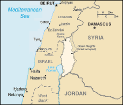
Голанские высоты ( арабский : : аль-Джалан , Романизированный : Хаубату л-д-д-д-джаллин или рафтат аль-Джалан , Муртафаату л-д-д-д-д-джавлана ; иврит Хатиба רמת הגולן , Раголан , ), или просто голан , является базальтовым плато , в юго -западном углу Сирии . Он граничит с рекой Ярмук на юге, морем Галилейского и долины Хула на западе, горами Антибанана с горой Хермон на севере и Вади Раккадом на востоке. Две трети этого района были заняты Израилем международным после шестидневной войны в 1967 году , а затем эффективно аннексировали в 1981 году-действие, не признанное сообществом , которое продолжает считать ее оккупированной израильской сирийской территорией.
Самое раннее доказательство жилья человека на Голане датируется верхним палеолитическим периодом. [ 9 ] Во время железного века он был домом для библейского Гешура , который впоследствии был включен в Арам-Дамаск . [ 10 ] [ 11 ] После ассирийского , вавилонского и персидского правления регион попал под контроль Александра Великого в 332 г. до н.э. [ 12 ] [ 13 ] Итуюрское ненадолго королевство и династия Хасмоне, управляли Голан, тогда Римская империя взяла под контроль, сначала через династию Геродиан , а затем управляя напрямую. [ 14 ] [ 15 ] [ 16 ] Впоследствии византийское , выдвинутое в Гусанидское королевство, правило Голан с 3 -го века, до тех пор, пока регион не был аннексирован халифатом Рашидун во время мусульманского завоевания Леванта в 7 -м веке. Умайяд Халифат , Аббасид Халифат , Фатимид Халифат и султанат Мамлука сменили друг друга под контролем Голана, прежде чем регион был завоеван Османской империей в 16 -м веке. [ 17 ] В Османской Сирии Голан был частью Сирии Вилайет . [ 18 ] Позже район стал частью французского мандата в Сирии и штате Дамаск . [ 19 ] Когда мандат прекратился в 1946 году, он стал частью недавно независимой сирийской арабской республики , охватывающей около 1800 км. 2 (690 кв. МИ).
После шестидневной войны 1967 года западные две трети голанских высот были заняты и управляемые Израилем, [ 1 ] [ 2 ] тогда как восточная треть остается под контролем Сирии. После войны Сирия отклонила любые переговоры с Израилем в рамках резолюции Хартума на саммите Лиги арабов . [ 20 ] Строительство израильских поселений началось в оставшейся части территории, удерживаемой Израилем, которая находилась под военной администрацией до тех пор, пока Кнессет принял закон Голанской высоты в 1981 году, который применил израильский закон к территории; [ 21 ] Движение было описано как аннексия . Закон о Голан -Хайтс был осужден Советом Безопасности Организации Объединенных Наций по резолюции 497 , [ 2 ] [ 22 ] который заявил, что «решение израильцев навязывать свои законы, юрисдикцию и администрацию в оккупированных сирийских голах -высотах, является недействительным и без международного правового эффекта».
После начала гражданской войны в Сирии в 2011 году контроль над сирийской вознагражденной частью Голанских высот был разделен между правительством штата и сирийскими оппозиционными силами , а силы наблюдателя Организации Объединенных Наций поддерживают 266 км. 2 (103 кв. МИ) Буферная зона между ними, чтобы помочь реализовать израильское -сирийское прекращение огня через фиолетовую линию . [ 23 ] С 2012 по 2018 год восточная половина Голан-Хайтс стала сценой многократных сражений между сирийской армией , повстанческих групп сирийской оппозиции (включая южный фронт , поддерживаемый Соединенными Штатами ), а также различные джихадистские организации, такие как Аль-Нусра Фронт и Исламское государство Ирак и связанная с Армия Халида Аль -Валида, Левантом . В июле 2018 года правительство Сирии восстановило полный контроль над восточными голанскими высотами. [ 24 ]
Этимология
В Библии Голан упоминается как город убежища, расположенный в Башане : Второзаконие 4:43 , Иисус, Джошуа 20: 8 , 1 Хроники 6:71 . [ 25 ] Авторы девятнадцатого века интерпретировали слово Голан как означает «что-то окруженное , отсюда и район ». [ 26 ] [ 27 ] Сдвиг в значении Голана, от города к более широкому району или территории, впервые засвидетельствовано еврейским историком Иосифом . Его аккаунт, вероятно, отражает римские административные изменения, введенные после великого еврейского восстания (66–73 г. н.э.). [ 28 ]
Греческое Гауланитис для - . региона название [ 29 ] В Мишне название Габлан, похожее на имена арамейских языков для региона: Гавлана , Гувлана и Гублана . [ 29 ]
Арабское Джаун - , имя [ 29 ] Иногда романизирован как Джолан , который является арабизованной версией ханаанитского и иврита . [ 30 ] Арабские картографы византийского периода называли область Джабал ( جَبَل , «гора»), хотя регион является плато. [ 31 ] [ сомнительно - обсудить ]
Название Golan Heights не использовалось до 19 -го века. [ 25 ]
История
Ранняя история
Венера Берехат Рам , галька из нижней палеолитической эры, найденной на высотах Голан, могла быть вырезана Homo Erectus от 700 000 до 230 000 г. до н.э. [ 32 ]
Южный Голан увидел рост поселений со второго тысячелетия до н.э. Это были небольшие поселения, расположенные на склонах с видом на море Галилее или близлежащие ущелья. Они могут соответствовать «городам Земли Га [Шу] Ру », упомянутым в письме № 256.5 Амарны, написанном Принцем Пихилу ( Пелла ). Это предполагает другую форму политической организации по сравнению с распространенными городскими государствами региона, такими как Хазор на западе и Аштерот на востоке. [ 33 ] Во время позднего бронзового века Голан был только редко заселен. [ 34 ]
После краха позднего бронзового века Голан был домом для недавно сформированного королевства Гешура , [ 35 ] Вероятно, продолжение более ранней « Земли Га [Шу] Ру ». [ 33 ] [ 34 ] Еврейская Библия упоминает об этом как отдельную сущность во время правления Давида (10 века до нашей эры). Брак Дэвида с Маачской, дочерью короля Талмай из Гешура, поддерживает династический союз с Израилем. [ 33 ] Однако к середине 9-го века до н.э. Арам-Дамаск поглотил Гешура на свою расширяющуюся территорию. [ 35 ] [ 33 ] [ 36 ] Соперничество Арам-Дамаска с Королевством Израиль привело к многочисленным военным столкновениям в регионах Голана и Галаада в течение 9-го и 8-го веков до нашей эры. Библия рассказывает о двух израильских победах в Афеке, место, возможно, соответствующее современному Afik , недалеко от Галилее. [ 33 ]
В течение 8 -го века до н.э. ассирийцы завоевали регион, включив его в провинцию Карнайм, вероятно, включая Дамаск . [ 34 ] Этот период был сменен вавилонской и Ахеменидной империей . В 5 -м веке до нашей эры империя Ахеменидов позволила переселить регион, возвращая еврейские изгнания из вавилонского плена , факт, который был отмечен в мозаике Рехоба . [ 12 ] [ 13 ] [ 11 ]
После ассирийского периода около четырех веков предоставляют ограниченные археологические находки в Голане. [ 37 ]
Эллинистические и ранние римские периоды
Голанские высоты, наряду с остальной частью региона, попали под контроль Александра Великого в 332 г. до н.э. после битвы за Ийссус . После смерти Александра Голан попал в доминирование генерала Македонского Селекуса и оставался частью империи Селевкида в течение большей части следующих двух столетий. [ 38 ] В середине 2 -го века до нашей эры итурицы переехали в Голан, [ 39 ] Занимая более ста мест в регионе. [ 40 ] Итуюрские камни и керамика были найдены в этом районе. [ 41 ] Итюрицы также построили несколько храмов, один из которых работал до исламского завоевания. [ 42 ]
Около 83–81 гг. До н.э. Голан был захвачен королем Хасмоня и первосвященником Александра Яннэя , аннексировав этот район к Хасмонеанскому царству Иудеи . [ 43 ] После этого завоевания Hasmoneans поощряли еврейских мигрантов из Иудеи поселиться в Голане. [ 44 ] Большинство ученых согласны с тем, что это урегулирование началось после завоевания Hasmonean, хотя оно могло начаться раньше, [ 16 ] Вероятно, в середине 2-го века до н.э. [ 45 ] В течение следующего столетия еврейское поселение в Голане и близлежащих регионах стало широко распространенным, дотянувшись от севера к Дамаску и на восток к Наве . [ 43 ]

Когда великий, вошел во второй в половине первого первого Иудеи во века до н.э. второй половине века до н.э. [ 46 ] После смерти Ирода Великого в 4 г. до н.э. Август Цезарь принял решение о том, что Голан попал в тетрархию сына Ирода, Ирода Филиппа I. [ 44 ] Столица еврейского галаунита, Гамла , была выдающимся городом и основной оплотом. [ 47 ] В нем размещался один из самых ранних известных синагог , который, как полагают, был построен в конце 1 -го века до нашей эры, когда храм в Иерусалиме все еще стоял. [ 48 ] [ 49 ]
После смерти Филиппа в 34 году н.э. римляне впитали Голана в провинцию Сирию , но Калигула восстановила территорию внуку Ирода Агриппы в 37 лет. После смерти Агриппы в 44 годах римляне снова аннексировали Голан в Сирию. Когда Клавдий обменял Голан на Агриппу II , сын Агриппы I, в 51 как часть обмена землей. [ Цитация необходима ]
Ко времени великого еврейского восстания , начавшегося в 66 году нашей эры, части Голанских высот были преимущественно населены евреями. Иосиф, изображающий западный и центральный Голан как густонаселенные городами, которые появились на плодородной каменистой почве. [ 43 ] Несмотря на то, что номинально находится под контролем Агриппы и расположена за пределами провинции Иудеи , еврейские общины в этом районе участвовали в восстании. Первоначально Гамла была лояльной к Риму, но позже город переключил верность и даже изгонял свои собственные монеты восстания. [ 45 ] [ 50 ] Иосифус, который был назначен временным правительством в Иерусалиме в качестве командира Галилее, укрепил города Согана, Селесия и Гамла в Голане. [ 50 ] [ 43 ] Римские военные под северное командованием Веспасиана в конечном итоге закончили восстание в 67 году нашей эры, захватив Гамлу после осады. Джозефус сообщает, что жители Гамлы выбрали массовое самоубийство , бросая себя в овраг. [ 43 ] Сегодня видимое нарушение в стене возле синагоги, а также остатки, такие как стены крепости, руины башни, фрагменты брони, различные снаряды и повреждение огня, свидетельствуют о интенсивности осады. [ 45 ]
После разрушения Иерусалима в 70 году нашей эры многие евреи бежали на север в Галилею и Голан, еще больше увеличив еврейское население в регионе. [ 43 ] Еще один заметный всплеск еврейской миграции в Голан произошел после восстания Bar Kokhba , c. 135 г. н.э. [ 43 ] В течение этого времени евреи оставались меньшинством населения в Голане. [ 51 ]
Поздние римские и византийские периоды


В более поздние римские и византийские периоды область вводилась в рамках Фениции Прима и Сирии Палеест , и, наконец, Голан/Гауланит был включен вместе с Peraea [ 52 ] В Палестине , после 218 г. н.э. [ 53 ] Площадь древнего королевства Башан была включена в провинцию Батанея . [ 54 ] К концу второго века Иуда Ха-Наси получил аренду за 2000 единиц земли в Голане. [ 55 ] Раскопки, проводимые в гиппотах, недавно обнаружили неизвестную римскую дорогу, которая связывала Галилеевое море с городом Нава в Сирии . [ 56 ]
Политическое и экономическое восстановление Палестины во время правления Диоклетиана и Константина , в конце 3 -го и начале 4 -го веков нашей эры, привело к возрождению еврейской жизни в Голане. Раскопки на различных сайтах синагоги обнаружили керамику и монеты, которые свидетельствуют о том, чтобы это переселение. [ 57 ] В течение этого периода было построено несколько синагог , и сегодня были обнаружены 25 мест с древними синагогами или их остатками, все расположены в центральном Голане. Эти синагоги, построенные из обильных базальтовых камней региона, находились под влиянием тех, кто в Галилее, но демонстрировали свои собственные отличительные характеристики; Выдающиеся примеры включают UMM El-Qanatir , Katzrin и Deir Aziz . [ 57 ] Некоторые из ранних иерусалимских трактатов Талмуда могли быть организованы и отредактированы в течение этого периода в Кацрине. [ 58 ] [ 55 ] Несколько участков в Голане показывают доказательства разрушения от еврейского восстания против Галласа в 351 году. Тем не менее, некоторые из этих участков были позже перестроены и продолжали обижаться в последующие века. [ 55 ]
В 5 -м веке Византийская империя назначила гасанидов , христианское арабское племя, которое поселилось в Сирии , задача защитить его восточные границы от сасанианского арабского племени, лахмиды . [ 59 ] Гасаниды эмигрировали из Йемена в третьем веке и активно поддерживали Византию против Персии. [ 60 ] Первоначально они были кочевыми, но постепенно стали полусменными, [ 59 ] и принято христианство вместе с рядом арабских племен, расположенных в границах Византийской империи в 3 -м и 4 -м веках. [ 61 ] Гасаниды приняли монофизитизм в 5 веке. [ 62 ] В конце 5 -го века основными лагерями Гассанида в Голане были Джабия и Джалалан , расположенные в восточном Голане за Руккадом . [ 63 ] [ 64 ] [ 59 ] Гасаниды обосновались глубоко внутри византийских лаймов , и в сирийском источнике за июль 519 года они засвидетельствованы как их «роскошные» штаб -квартиру в восточной Галлантиде . [ 65 ] Как и иродийская династия перед ними, гасаниды правили как клиентское состояние Рима - на этот раз христианская восточная Римская империя или Византия. В 529 году император Джастиниан назначил Аль-Харита Ибн Джабала в качестве Филарха , сделав его лидером всех арабских племен и дает ему титул Патрициуса, ранжируя чуть ниже императора. [ 59 ]
Христиане и арабы стали большинством в Голане с прибытием гасанидов в регион. [ 66 ] В CE 377 было создано святилище для Иоанна Крестителя в деревне Голан Эр-Рамтании . [ 67 ] Святилище часто посещали гасаниды. [ 68 ]
В 6-м веке Голан был заселен устоявшимися евреями и христианами Гассанида. [ 62 ] [ 69 ] Еврейское население в Голане занималось сельским хозяйством, о чем свидетельствует доисламский арабский поэт Муракквиш младшего, который упомянул вино, привезенное еврейскими торговцами из региона, [ 70 ] и местные синагоги, возможно, финансировались за счет процветающего производства оливкового масла. [ 71 ] Монастырь и церковь, посвященные святому Георгия, были найдены в византийской деревне Дейр Керух в Голане, расположенной недалеко от Гамлы. Церковь имеет квадратную апсиду - черту, известную из древней Сирии и Иордании, но не присутствующей в церквях к западу от реки Иордан . [ 72 ]
Гасаниды смогли держаться за Голан до вторжения Сасанида 614. После краткого восстановления под императором Гераклия голан снова упал, на этот раз вторгающихся мусульманских арабах после битвы при Ярмуке в 636 году. [ 73 ] Данные обзоров и раскопок объединены, показывают, что основная часть участков в Голане была заброшена между концом 6 -го и начала 7 -го века в результате военных вторжений, разрыва закона и порядка и экономики, вызванной ослаблением византия правило Некоторые поселения длились до конца эпохи Омейяда. [ 74 ]
Ранний мусульманский период
После битвы при Ярмуке Муавия I , член племени Мухаммеда , Корайш , был назначен губернатором Сирии, включая Голан. После убийства своего двоюродного брата, халиф Утман , Муавия заявил о себе халифат, инициируя династию Омейяд . В течение следующих нескольких столетий, оставаясь в мусульманских руках, Голан прошел через многие династические изменения, сначала падая в Аббасиды , а затем в шиитские фтимиды , затем на турки сельджук . [ Цитация необходима ]
Землетрясение опустошило еврейскую деревню Кацрин в 746 году нашей эры. произошел короткий период значительно сниженного занятия После этого в течение периода Аббасида (приблизительно 750–878). Еврейские общины сохранялись, по крайней мере, в средние века в городах Фик на юге Голана и Нава в Батанеи. [ 75 ]
В течение многих веков кочевые племена жили вместе с сидячим населением в регионе. Время от времени центральное правительство пыталось урегулировать кочевников, что приведет к созданию постоянных сообществ. Когда власть руководящего режима снизилась, как это произошло в начале мусульманского периода, кочевые тенденции увеличились, и многие из сельских сельскохозяйственных деревень были брошены из -за преследований со стороны бедуинов . Они не были переселены до второй половины 19 -го века. [ 76 ]
Период Crusader/Ayyubid

Во время крестовых походов высоты представляли собой препятствие для армий крестоносцев, [ 77 ] [ 78 ] Тем не менее, дважды занимал стратегически важный город Баниас , в 1128–32 и 1140–64. [ 79 ] После побед султана Нур Ад-Дина Занги , это была курдская династия айюбидов под руководством султана Саладина , которая управляла этим районом. Монголы султаном пробежали в 1259 году, но были отведены командиром Мамлука и будущим Кутуз в битве при Айн Джалут в 1260 году. [ Цитация необходима ]
Победа в Ain Jalut обеспечила Mamluk в течение следующих 250 лет. доминирование в регионе [ Цитация необходима ]
В 15-16-м веке племя аль-Фадла покинуло северо-восточную Сирию после внутреннего конфликта. [ 80 ] Они утверждают, что являются потомками Аббаса ибн Абд аль-Мутталиб , дядей исламского пророка Мухаммеда . [ 81 ] После того, как они прибыли в Голанские высоты, в этом районе разразилось столкновение. [ 82 ] Племя поселилось в нескольких деревнях в этом районе и контролировало важные дороги с Дамаской , Галилеем и Ливаном. [ 83 ] Они работали с сельским хозяйством и домашним скотом. [ 84 ] В 19 -м веке племя продолжало расширять свою территорию в Голане и построило два дворца. [ 85 ] Лидер племени присоединился к Фейсалу во время арабского восстания , [ 86 ] и они поддержали восстание против французов в северном Голане. [ 87 ] Лидеры племени были вытеснены из Голана во время войны в 1967 году. [ 88 ]
Османский период

В 16 -м веке османские турки завоевали Сирию. В течение этого времени Голан составлял часть южного округа их империи. Некоторые общины друзов были созданы в Голане в течение 17 и 18 веков. [ 90 ] Деревни, отброшенные в предыдущие периоды из -за набегов со племенами бедуинов, не были переселены до второй половины 19 -го века. [ 76 ] В 1868 году регион был описан как «почти полностью пустынный». Согласно руководству по путешествиям того времени, было заселено только 11 из 127 древних городов и деревень в Голане. [ 91 ]
В результате руссо-турецкой войны произошел огромный приток беженцев 1877–78 годов в Империи в Империю в Империю в Империю в Империю . Османы поощряли их поселиться на юге Сирии, особенно на Голан-Хайтс, предоставив им землю с 12-летним налоговым освобождением. [ 92 ] [ 93 ] [ 94 ] В 1885 году инженер -строитель и архитектор Готлиб Шумахер провел обзор всей Голанской высоты от имени Германского общества за исследование Святой Земли, опубликовав свои выводы на карте и книге под названием «Джаул» . [ 95 ] [ 96 ]
В конце 19-го века Голанские высоты в основном заселивали арабами , туркменами и циркасами . [ 97 ]
Раннее еврейское поселение
В 1884 году между деревнями в Нижнем Голане все еще были открытые участки некультивированной земли, но к середине 1890-х годов большинство из них принадлежало и культивировано. [ 98 ] Некоторая земля была приобретена в Голане и Гаране сионистскими ассоциациями, базирующимися в Румынии, Болгарии, Соединенных Штатах и Англии, в конце 19 -го века и начале 20 -го века. [ 99 ] В 1880 году Лоуренс Олифант опубликовал Эрец Ха-Гилад (Земля Галаада ), в котором описан план крупномасштабного еврейского поселения в Голане. [ 100 ]
Зимой 1885 года члены Старого Ишува в Сейде сформировали общество Бейт Иегуда и приобрели 15 000 дюнам земель в деревне Рамтании в Центральном Голане. [ 101 ] Из-за финансовых трудностей и долгого ожидания Кушана ( османского земельного дела) деревня, Голан Бэ-Башан, была заброшена через год. [ Цитация необходима ]
Вскоре после этого общество перегруппировалось и приобрело 2000 дунам земли в деревне Бир Э-Шагум на западных склонах Голана. [ 102 ] Деревня, которую они основали, Bnei Yehuda , существовала до 1920 года. [ 103 ] [ 104 ] Последние семьи остались после пасхальных беспорядков 1920 года . [ 101 ] В 1944 году JNF купил земли Bnei Yehuda у своих еврейских владельцев, но более поздняя попытка установить еврейскую собственность на имущество в Bir E-Shagum через суды не была успешной. [ 103 ]
В период с 1891 по 1894 год барон Эдмонд Джеймс де Ротшильд приобрел около 150 000 дунам земель в Голане и Гаране для еврейского поселения. [ 101 ] Юридические и политические разрешения были обеспечены, и право собственности на землю было зарегистрировано в конце 1894 года. [ 101 ] Евреи также построили дорогу, простирающуюся от озера Хула до Музайриба . [ 103 ]
Общество Агудат Ахим, штаб -квартира которого находилась в Екатеринославе , Россия, приобрело 100 000 дунам земли в нескольких местах в районах Фика и Дараа . Был создан питомник растений, и началась работа над сельскохозяйственными зданиями в Джиллине . [ 101 ]
Деревня под названием Tiferet Binyamin была создана на землях, приобретенных у Сахам аль-Джаллан Ассоциацией Shavei Zion, базирующейся в Нью-Йорке, в Нью-Йорке, [ 99 ] Но проект был отброшен через год, когда турки выпустили указ в 1896 году, выселяя 17 не турецких семей. Более поздняя попытка переселить сайт с сирийскими евреями, которые были османскими гражданами, также потерпела неудачу. [ 105 ]
В период с 1904 по 1908 год группа крымских евреев поселилась недалеко от арабской деревни Аль-Бурая в долине Бетсайды , изначально как арендаторы курдского владельца с перспективами покупки земли, но договоренность задумалась. [ 106 ] [ 107 ]
Еврейское поселение в регионе сократилось с течением времени из -за арабской враждебности, турецкой бюрократии, болезней и экономических трудностей. [ 108 ] В 1921–1930 годах, во время французского мандата, Ассоциация еврейской колонизации Палестины (PICA) получила дела в поместье Ротшильд и продолжала управлять им, собирая арендную плату у арабских крестьян, живущих там. [ 103 ]
Французские и британские мандаты
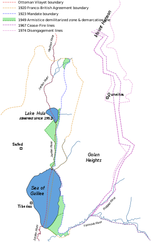
Великобритания приняла мандат на Палестину на заседании Верховного совета союзников в Сан -Ремо , но на этом этапе границы территории не были определены. [ 109 ] [ 110 ] Граница между предстоящими британскими и французскими мандатами была определена в общих терминах Франко -Британским граничным соглашением декабря 1920 года. [ 111 ] Это соглашение разместило большую часть высот Голан во французской сфере. Договор также установил совместную комиссию для урегулирования точных деталей границы и отметить ее на земле. [ 111 ]
Комиссия представила свой окончательный отчет 3 февраля 1922 года, и 7 марта 1923 года она была утверждена с некоторыми оговорками британских и французских правительств, за несколько месяцев до того, как Британия и Франция взяли на себя обязательные обязанности 29 сентября 1923 года. [ 112 ] [ 113 ] В соответствии с тем же процессом, ближайший участок земли, который включал в себя древнее место Тель -Дана и Дэна Спринг, была перенесена из Сирии в Палестину в начале 1924 года.
Голанские высоты, в том числе весна в Ваззани и такую в Баниасе , стали частью французской Сирии , в то время как Галилейское море было полностью помещено в британскую обязательную Палестину. Когда французский мандат на Сирию закончился в 1944 году, Голанские высоты стали частью недавно независимого штата Сирия, а затем были включены в мухафаус Кунеитра .
Пограничные инциденты после 1948 года
После арабской войны гг . в 1948–49 В течение следующих лет район вдоль границы стал свидетелем тысяч насильственных инцидентов; Соглашение о перемирии было нарушено обеими сторонами. Основными причинами конфликта были разногласия по поводу правового статуса демилитаризованной зоны (DMZ), выращивание земли внутри нее и конкуренцию над водными ресурсами. Сирия утверждала, что ни одна из сторон не имела суверенитета над DMZ. [ 114 ] [ 115 ]
Израиль утверждал, что соглашение о перемирии касается исключительно военных проблем и что оно имело политические и законные права на DMZ. Израиль хотел отстаивать контроль до границы 1923 года, чтобы вернуть себе болото Хула , получить исключительные права на озеро Галилее и отвлечь воду от Иордании для своего национального водопроводчика . В течение 1950 -х годов Сирия зарегистрировала два основных территориальных достижения: она взяла на себя корпус Аль -Хамма к югу от озера Тиберия и установила фактическое присутствие и контроль над восточным берегом озера. [ 114 ] [ 115 ]
Израиль изгнал арабов из DMZ и снесла свои дома. [ 116 ] Палестинским беженцам было отказано в праве возвращения или компенсации, и из -за этого они начали рейды на Израиль. [ 117 ] Сирийское правительство поддержало палестинские атаки из -за того, что Израиль захватил больше земли в DMZ. [ 118 ]
Соединенные эксперты в Лиге арабских и Израиле были согласованы Объединенным планом воды в долине Джордан и согласованы техническими экспертами Лиги арабских и Израиля. [ 119 ] США финансировали проекты израильского и иорданского водоснабжения, когда они обязались соблюдать распределение плана. [ 120 ] Президент Насер тоже заверил США, что арабы не будут превышать квоты по воде плана. [ 121 ] Тем не менее, в начале 1960 -х годов Лига арабских лиг финансировала сирийский проект диверсии воды, который лишил бы использование Израиля в основной части его распределения воды. [ 122 ] Полученные вооруженные столкновения называются войной над водой . [ 123 ]
В 1955 году Израиль начал атаку, в результате которого погибли 56 сирийских солдат. Атака была осуждена Советом Безопасности Организации Объединенных Наций. [ 124 ]
в июле 1966 года, [ 125 ] Фата начал рейды на израильскую территорию, при активной поддержке Сирии. Сначала боевики вошли через Ливан или Иордан, но эти страны предприняли согласованные попытки остановить их, а набеги непосредственно из Сирии увеличились. [ 126 ] Ответ Израиля была серией ответных набегов, самыми крупными были нападение на иорданскую деревню Саму в ноябре 1966 года. [ 127 ] В апреле 1967 года, после того, как Сирия сильно обрушилась израильскими деревнями из Голанских высот, Израиль сбил шесть сирийских MIG и предупредил Сирию от будущих атак. истребителей [ 126 ] [ 128 ]
Израильтяне привыкли отправлять тракторы с вооруженной полицией в DMZ, что побудило Сирию стрелять в Израиль. [ 129 ] В период между первой арабской войной и шестидневной войной сирийцы постоянно преследули израильские пограничные общины, запуская артиллерийские снаряды со своих доминирующих позиций на Голанских высотах. [ 130 ] В октябре 1966 года Израиль принес этот вопрос перед Организацией Объединенных Наций. Пять стран спонсировали резолюцию, критикующую Сирию за ее действия, но не удалось пройти из -за советского вето. [ 131 ] [ 132 ] Ни одна из Израильских гражданских лиц не было убито в течение полугода, что привело к шестидневной войне, и сирийские нападения были названы: «в значительной степени символическими». [ 133 ]
Бывший израильский генерал Маттитиху Пел сказал, что более половины столкновений пограничных столкновений до войны в 1967 году «стали результатом нашей политики безопасности максимального урегулирования в демилитаризованном районе». [ 134 ] [ Лучший источник необходим ] Израильские вторжения в зону были реагированы на стрельбу сирийцев. Израиль, в свою очередь, ответил на военную силу. [ 114 ]
В 1976 году бывший министр обороны Израиля Моше Даян заявил, что Израиль спровоцировал более 80% столкновений с Сирией в преддверии войны 1967 года, хотя израильские историки обсуждают, является ли он «точным отчетом о ситуации в 1967 году или его Версия того, что произошло, была окрашена его позором после войны на Ближнем Востоке 1973 года, когда он был вынужден уйти в отставку с поста министра обороны из -за неспособности предвидеть арабскую атаку ». [ 135 ] Провокация посылала трактор для падения в демилитаризованных областях. Сирийцы ответили, стреляя в тракторов и обстреливая израильские поселения . [ 136 ] [ 137 ] Ян Мюхрен, бывший наблюдатель ООН в этом районе в то время, сказал голландской программе текущих дел, что Израиль «спровоцировал большинство пограничных инцидентов в рамках своей стратегии, чтобы приложить большую землю». [ 138 ] Чиновники ООН обвинили как Израиль, так и Сирию в дестабилизации границ. [ 139 ]
Шестидневная война и израильская оккупация
После того, как в июне 1967 года началась шестидневная война, обстрел Сирии значительно усилился [ Нейтралитет оспаривается ] и израильская армия захватила Голанские высоты 9–10 июня . Площадь, которая оказалась под контролем израиля в результате войны, состоит из двух геологически различных областей: вершины голанства, с поверхностью 1070 км. 2 (410 кв. МИ) и склоны хребта горы Хермон, с поверхностью 100 км 2 (39 кв. Миль). Новая линия прекращения огня была названа фиолетовой линией . В битве 115 израильтян были убиты и 306 ранены. По оценкам, 2500 сирийцев были убиты, а еще 5000 ранены. [ 140 ]

Во время войны от 80 000 человек [ 141 ] и 131 000 [ 142 ] Сирийцы бежали или были изгнаны с высот, и около 7000 оставалось на территории, занятой израильской, оккупированной израильской,. [ 142 ] Израильские источники и Комитет США по делам беженцев и иммигрантов сообщили, что большая часть местного населения в 100 000 человек бежала в результате войны, тогда как правительство Сирии заявило, что большая часть его была исключена. [ 143 ] Израиль не позволил бывшим жителям вернуться, сославшись на соображения безопасности. [ 144 ] Остальными деревнями были Мадждал Шамс , Шайта (позже уничтожен), Эйн Циние , Масаде , Бук'ата и, за пределами собственного Голана, Гхаджар .
Израильское поселение в Голане началось вскоре после войны. Merom Golan была основана в июле 1967 года, и к 1970 году было 12 поселений. [ 145 ] Строительство израильских поселений началось в оставшейся части территории, удерживаемой Израилем, которая находилась под военной администрацией до тех пор, пока Израиль принял закон Голанской высоты, расширяющий закон и администрацию Израиля на протяжении всей территории в 1981 году. [ 21 ] 19 июня 1967 года израильский кабинет проголосовал за возвращение Голана в Сирию в обмен на мирное соглашение, хотя это было отклонено после резолюции Хартума от 1 сентября 1967 года. [ 146 ] [ 147 ] В 1970-х годах, в рамках плана Аллона , израильский политик Игал Аллон предложил создать государство друзы в сирийском мухафалле Кунеиры , включая израильские голанские высоты. Аллон умер в 1980 году, и его план никогда не осуществлялся. [ 148 ]
Йом Кипур война
Во время войны в Йом Кипур в 1973 году сирийские войска завоевали большую часть южного Голана, прежде чем их отодвинут израильский контратака. В 1974 году Израиль и Сирия подписали соглашение о прекращении огня, которое оставило почти все высоты в руках Израиля. Соглашение о прекращении огня 1974 года между Израилем и Сирией определено демилитаризованную зону вдоль своей границы и ограничивало количество сил, каждая из которых может развернуть в пределах 25 километров (15 миль) от зоны. [ 149 ]
К востоку от линии прекращения огня 1974 года лежит сирийская контролируемая часть высоты, область, которая не была захвачена Израилем (500 квадратных километров или 190 кв. Миль) или отозвана из (100 квадратных километров или 39 кв. Миль). Эта область образует 30% высоты Голана. [ 150 ] Сегодня, [ когда? ] Он содержит более 40 сирийских городов и деревень. В 1975 году, после Соглашения о прекращении огня 1974 года, Израиль вернул узкую демилитаризованную зону в сирийский контроль. Некоторые из перемещенных жителей начали возвращаться в свои дома, расположенные в этой полосе, и сирийское правительство начало помогать людям перестроить свои деревни, за исключением Кунитры . В середине 1980-х годов правительство Сирии запустило план под названием «Проект для реконструкции освобожденных деревень». [ Цитация необходима ] К концу 2007 года население мухафалиста Кунеитра оценивалось в 79 000 человек. [ 151 ]
После войны в Йом Киппур 1973 года, в которой Сирия пыталась, но не смогла вернуть Голан, Израиль согласился вернуть около 5% территории на сирийский гражданский контроль. Эта часть была включена в демилитаризованную зону, которая проходит вдоль линии прекращения огня и простирается на восток. Эта полоса находится под военным контролем Undof . [ Цитация необходима ]
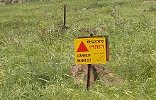
Гробы, развернутые сирийской армией, остаются активными. По состоянию на 2003 год в Голане, по меньшей мере, 216 пострадавших за минами в Голане, контролируемом сирийцем с 1973 года, из которых 108 были погибшими. [ 152 ]
Фактически аннексия израилем и гражданским правлением

14 декабря 1981 года Израиль принял закон о Голан -Хайтс , [ 21 ] Это расширило израильские «законы, юрисдикцию и администрацию» на высоты Голан. Хотя закон эффективно аннексировал территорию в Израиль, он явно не изложил формальную аннексию. [ 153 ] Закон о Голан -Хайтс был объявлен «недействительным и без международного юридического эффекта» Резолюцией Совета Безопасности Организации Объединенных Наций 497 , что также потребовало от того, что Израиль отменил свое решение. [ 154 ] [ 155 ] [ 2 ] [ 22 ]
В ходе переговоров, касающихся текста резолюции 242 Совета Безопасности Организации Объединенных Наций, государственный секретарь США Дин Раск объяснил, что поддержка США для безопасных постоянных границ не означала, что Соединенные Штаты поддержали территориальные изменения. [ 156 ] Представитель ООН в Соединенном Королевстве, который отвечал за переговоры и составление резолюции Совета Безопасности, заявил, что действия правительства Израиля в установлении поселений и колонизации Голана находятся в явном неповиновении резолюции 242. [ 157 ]
Сирия продолжала требовать полного израильского ухода на границы 1967 года, в том числе полосу земли на восточном берегу Галилейского моря , которую Сирия захватила во время арабо -израильской войны 1948–49 гг. Считается израильским отменой из Голана в обмен на нормализацию отношений с Сирией, при условии, что определенные проблемы безопасности выполняются. До 2000 года президент Сирии Хафес аль-Асад отклонил нормализацию с Израилем.
С момента принятия закона о Голан-Хайтс Израиль рассматривал оккупированную Израильской частью части Голанских высот в качестве районы его северного округа . [ 158 ] Самая большая местность в регионе - деревня Друз Мадждал Шамс, которая находится у подножия горы Хермон, в то время как Кацрин является крупнейшим израильским поселением . Регион имеет 1176 квадратных километров. [ 158 ] Субэтрист имеет плотность населения 36 жителей на квадратный километр, [ Цитация необходима ] и его население включает в себя арабских, еврейских и дружищих граждан. В округе 36 мест, из которых 32 являются еврейскими поселениями, а четыре - деревни Друз. [ 159 ] [ 160 ]
План создания поселений, которые первоначально начались в октябре 1967 года с запроса о региональном плане сельскохозяйственного урегулирования для Голана, был официально утвержден в 1971 году, а затем пересмотрен в 1976 году. План призвал к созданию 34 поселений 1995, одним из которых станет городской центр, Кацрин и остальные сельские поселения, с населением 54 000 человек, среди которых 40 000 городских и оставшихся сельских районов. К 1992 году было создано 32 поселения, среди которых один город и два региональных центра. Всего населения, однако, не достигло целей Израиля, в 1992 году только 12 000 еврейских жителей в Голанских поселениях в 1992 году. [ 161 ]
Муниципальные выборы в городах Друз
В 2016 году группа юристов друзы обратилась к Верховному суду Израиля, чтобы разрешить выборы местных советов в Голане Друзе города Мадждал Шамс , Бук'ата , Масаде и Эйн Циние , заменив предыдущую систему, в которой их члены были назначен национальным правительством. [ 162 ]
3 июля 2017 года Министерство внутренних дел объявило, что эти города будут включены в муниципальные выборы в израильских выборах в 2018 году . Явка была чуть более 1% [ 163 ] с Druze религиозными лидерами, рассказывающими членам сообщества бойкотировать выборы или лицу. [ 164 ] [ 165 ] [ 166 ]
Совет по правам человека ООН опубликовал резолюцию по правам человека в оккупированном сирийском Голане 23 марта 2018 года, в котором говорилось, что в июле 2017 года израильские власти, занимающие оккупирующие власти израильских властей, о том, что муниципальные выборы состоятся 30 октября 2018 года в четырех деревнях. В оккупированном сирийском Голане, который представляет собой еще одно нарушение международного гуманитарного права и соответствующих резолюций Совета Безопасности, в частности, резолюция 497 (1981) ».
Израильские - сирийские мирные переговоры
В ходе переговоров Соединенных Штатов в 1999–2000 годах Израиль и Сирия обсудили мирное соглашение, которое включало бы израильский уход в обмен на всеобъемлющую мирную структуру, признание и полную нормализацию отношений. Разногласия на последних этапах переговоров были на доступе к Галилее. Израиль предложил уйти на границу до 1948 года ( линия Paulet-Newcombe 1923 года ), в то время как Сирия настаивала на границе 1967 года. Первая линия никогда не была признана Сирией, утверждая, что она была навязана колониальными державами, в то время как последний был отвергнут Израилем в результате сирийской агрессии. [ 167 ]
Разница между линиями составляет менее 100 метров по большей части, но линия 1967 года даст Сирию доступ к морю Галилее, а Израиль хотел сохранить контроль над морем Галилее, его единственное пресноводное озеро и крупный водный ресурс Полем [ 167 ] Деннис Росс , главный переговорщик на Ближнем Востоке президента США Билла Клинтона , обвинил «холодные ноги» со стороны премьер -министра Израиля Эхуда Барака в этом разрыве. [ 168 ] Клинтон также возложил вину на Израиль, как он сказал после того, как в своей автобиографии моя жизнь . [ 169 ]

В июне 2007 года сообщалось, что премьер-министр Эхуд Олмерт отправил секретное сообщение президенту Сирии Башару аль-Асаде , что Израиль уступит землю в обмен на всеобъемлющее мирное соглашение и разорение связей Сирии с Ираном и боевиками в группах в регион. [ 170 ] В тот же день бывший премьер -министр Бенджамин Нетаньяху объявил, что бывший президент Сирии Хафез Асад пообещал позволить Израилю удержать Маунт Хермон в любом будущем соглашении. [ 171 ]
В апреле 2008 года сирийские СМИ сообщили, что Реджеп премьер-министр Турции Тайип Эрдоган заявил президенту Башару Асаду, что Израиль выйдет из Голанских высот в обмен на мир. [ 172 ] [ 173 ] Израильские лидеры общин на Голанских высотах провели специальное собрание и заявили: «Все проекты по строительству и развитию в Голане идут вперед, как и планировалось, что способствовало уверенности в том, что любая попытка нанести вред израильскому суверенитету в Голане нанесет серьезный ущерб штату Безопасность и, следовательно, обречена на неудачу ». [ 174 ] Обследование 2008 года показало, что 70% израильтян выступают против отказа от Голана за мир с Сирией. [ 175 ]
В 2008 году пленарная сессия Генеральной Ассамблеи Организации Объединенных Наций приняла резолюцию 161–1 в пользу движения на высоте Голан, которое подтвердило резолюцию 497 Совета Безопасности ООН и призвала Израиль отказаться от «изменения физического характера, демографического состава,, Институциональная структура и правовой статус оккупированного сирийского Голана и, в частности, отказаться от установления поселений [и] навязывания израильского гражданства и израильских идентификационных карточек на граждане сирийцев в оккупированном сирийском Голане и от его репрессивных мер против населения оккупированного сирийского Голана ". Израиль был единственной нацией, которая проголосовала против резолюции. [ 176 ] Косвенные переговоры сломались после начала войны в Газе . Сирия прервала переговоры о протестах против израильских военных операций. Впоследствии Израиль обратился к Турции с просьбой возобновить посредничество. [ 177 ]
В мае 2009 года премьер -министр Нетаньяху сказал, что возвращение Голанских высот превратит его в « Фронт -линии Ирана , что угрожает всем штату Израиль». [ 178 ] [ 179 ] Он сказал: «Я помню Голанские высоты без Кацрина , и вдруг мы видим процветающий город на земле Израиля , который был жемчужиной второй Храмовой Эры, был заново возрожден». [ 180 ] Американский дипломат Мартин Индик сказал, что раунд переговоров в 1999–2000 годах начался во время первого семестра Нетаньяху (1996–1999), и он был не таким жестким, как он разобрался. [ 181 ]
В марте 2009 года президент Сирии Башар аль-Асад заявил, что косвенные переговоры провалились после того, как Израиль не взял на себя полное вывод с Голанских высот. В августе 2009 года он сказал, что возвращение всей Голанской высоты было «не подлежащим обсуждению», оно останется «полностью арабским» и будет возвращено в Сирию. [ 182 ]
В июне 2009 года президент Израиля Симон Перес сказал, что Асад должен будет вести переговоры без предварительных условий, и что Сирия не выиграет территориальные уступки от Израиля на «серебряном блюде», в то время как она поддерживала связи с Ираном и Хезболлой. [ 183 ] В ответ министр иностранных дел Сирии Валид Муаллем потребовал, чтобы Израиль безоговорочно уступил голанские высоты «на серебряном блюде» без каких -либо предварительных условий, добавив, что «это наша земля», и обвинил Израиль в том, что он не смог посвятить себя миру. Президент Сирии Асад заявил, что в Израиле не было «нет реального партнера». [ 184 ]
В 2010 году министр иностранных дел Израиля Авигдор Либерман сказал: «Мы должны заставить Сирию признать, что, так же, как она отказалась от своей мечты о большей Сирии, которая контролирует Ливан ... ей придется отказаться от своего окончательного требования относительно Голанских высот». [ 185 ]
Сирийская гражданская война
С 2012 по 2018 год в Сирийской гражданской войне восточные голанские высоты стали сценой многократных сражений между сирийской арабской армией , повстанческих фракций сирийской оппозиции, включая умеренный южный фронт и фронт джихадистов аль-Нусра и фракции , связанные с исламским фронтом Штат Ирак и террористическая группа Левант (ИГИЛ).
Зверства Сирийской гражданской войны и роста ИГИЛ, которые с 2016 по 2018 год контролируются части Голана, управляемого Сирии, добавили к этому вопросу новый поворот. В 2015 году сообщалось, что премьер -министр Израиля Бенджамин Нетаньяху попросил президента США Барака Обамы признать претензии израильцев на территорию из -за этих недавних действий ИГИЛ и потому, что он сказал, что современная Сирия, вероятно, «распадалась» за пределами воссоединения. [ 186 ] Белый дом отклонил предложение Нетаньяху, заявив, что президент Обама продолжал поддерживать резолюции ООН 242 и 497, и любые изменения этой политики могут напрягать американские альянсы с помощью сирийских повстанческих групп. [ 187 ]
В 2016 году Исламское государство извинилось перед Израилем после пожарной обмены с израильскими солдатами в этом районе. [ 188 ] В мае 2018 года Силы обороны Израиля (ИДФ) нанесли «обширные» воздушные удары по предполагаемым иранским военным установкам в Сирии после того, как на позициях израильской армии на высотах из Израильской армии были начаты 20 иранских ракет. [ 189 ]
17 апреля 2018 года после ракетных ударов 2018 года Соединенными Штатами, Францией и Великобританией около 500 Друз в Голаном городе Эйн Циние поступили в поддержку президента Сирии Башара аль-Асада Сирии в День независимости и и в осуждении американских ударов. [ 190 ] [ 191 ]
в течение месяца 31 июля 2018 года, после того, как переживание военного наступления против повстанцев и ИГИЛ, Сирийское правительство восстановило контроль над восточными голанскими высотами. [ 24 ]
2023-2024 война
В июне 2024 года Хезболла начал серию ответных ракетных и беспилотных атак на Голан -Хайтс, что привело к разрушению 10 000 дюнам открытых площадок огнем. Это было в ответ на нападение Израиля на цели Хезболлы в Ливане. Пожарный поврежден части лесного заповедника Иехудия , в том числе пешеходные тропы и черный каньон заповедника. По словам чиновника из Управления природы и парков , местной флоре потребуются годы, чтобы восстановиться. [ 192 ]
27 июля 2024 года ракета из южного Ливана ударила по футболу в городе Друз Мадждал Шамс на Голанских высотах. [ 193 ] Забастовка привела к гибели 12 детей друза. ИДФ заявил, что ракета была уволена Хезболлой, утверждение, которое Хезболла отрицала. [ 194 ]
Территориальные претензии
Утверждения на территорию включают в себя тот факт, что район на северо -западе региона Голан, определенный грубым треугольником, образованным городами Баниас , Кунитра и северной кончиком Галилейского моря , временно был частью британского палестинского мандата, в котором которого Создание еврейского национального дома было обещано. [ 195 ] В 1923 году этот треугольник на северо -западном Голане был уступил французскому мандату в Сирии, но в обмен на это земельные участки в Сирии и Ливане были уступили Палестине, и все море Галилее, у которого ранее была связана его восточная граница, и все море Галилее, которое ранее имело свою восточную границу, и все море Галилее, которое ранее имело свою восточную границу, и все море Галилее, которое ранее имело свою восточную границу, и все море Галилее, которое ранее имело свою восточную границу, и все море Галилее, которое ранее имело свою восточную границу, и все море Галилее, которое ранее имело свою восточную границу, и все море Галилее, которое ранее имело свою восточную границу, и все море Галилее, которое ранее имело свою восточную границу, и все море Галилее, которое ранее имело свою восточную границу, и все море Галилей Сирия была помещена в Палестину. [ 196 ]
Сирийский счетчик, что регион был помещен в вилайет Дамаск в рамках Сирии в соответствии с Османскими границами, и что франко-британское соглашение 1920 года , которое стало частью Голана под контролем Британии, было лишь временным. Сирия также утверждает, что окончательная пограничная линия, разработанная в 1923 году, которая исключила Голан -треугольник, заменила соглашение 1920 года, [ 195 ] Хотя Сирия никогда не признавала границу 1923 года как юридически обязательную.
Израиль считает, что Голанские высоты жизненно важны для своей национальной безопасности, утверждая, что контроль над регионом необходим для защиты от угроз со стороны сирийских и иранских прокси -групп . [ 197 ] Он утверждает, что он может сохранить область, так как текст резолюции 242 требует «безопасных и признанных границ, свободных от угроз или актов силы». [ 198 ]
Границы, линия перемирия и линия прекращения огня

Один из аспектов спора включает в себя существование до 1967 года из трех различных линий, отделяющих Сирию от области, которая до 1948 года называлась обязательной Палестиной .
Граница 1923 года между британской обязательной Палестиной и Французским мандатом Сирии была привлечена с учетом воды. [ 199 ] [ Лучший источник необходим ] Соответственно, он был разграничен так, что все море Галилее , включая полосу пляжа шириной 10 метров вдоль его северо-восточного берега, оставалось в обязательном Палестине . От моря Галилейского севера до озера Хула граница была нарисована между 50 и 400 метрами к востоку от верхней реки Иордан , сохраняя этот поток полностью внутри обязательной Палестины . Британцы также получили кусочек земли вдоль реки Ярмук , до современного Хамата Гейдера . [ 200 ]
Во время арабо-израильской войны Сирия захватила различные районы бывшей британской контролируемой обязательной Палестины , в том числе 10-метровую полосу пляжа, восточный берег Верхнего Иордана, а также районы вдоль Ярмука.
Ведя переговоры о соглашениях о перемирии 1949 года , Израиль призвал к удалению всех сирийских сил с бывшей Палестинской территории. Сирия отказалась, настаивая на линии перемирия, базирующейся не на международной границе 1923 года, а на военном статус -кво. Результатом был компромисс. В соответствии с условиями перемирия, подписанного 20 июля 1949 года, сирийские силы должны были уйти к востоку от Старой Палестин-Сирии границы. Израильские силы должны были воздерживаться от въезда в эвакуированные области, которые станут демилитаризованной зоной, «из которой вооруженные силы обеих сторон будут полностью исключены, и в которых не допускается никакие действия военных или военизированных сил». [ 201 ] [ Лучший источник необходим ]
Соответственно, основные части линий перемирия ушли от границы 1923 года. На западе Баниаса, на западном берегу реки Иордан возле озера Хула, на западе Банейс-берега, Галилее, на западе моря, простирающихся до Хамата, состоящего из 66,5 км, на западном море, на западном море, на западном море, на западном берегу реки реки Иордан, на западе реки Иордан, протянувшись к западу от Баниаса, на западном берегу Галилейского 2 (25,7 кв. Миль) земли, лежащую между линией перемирия 1949 года и границей 1923 года, образуя демилитаризованную зону. [ 199 ] [ Лучший источник необходим ]
После перемирия, и Израиль, и Сирия стремились воспользоваться территориальными неоднозначностями, оставленными в соответствии с соглашением 1949 года. Это привело к развивающейся тактической ситуации, один «снимок», который был расположением сил непосредственно перед шестидневной войной , «Линия от 4 июня 1967 года». [ 199 ] [ Лучший источник необходим ]
Шебаа фермы
Небольшая часть территории на голанских высотах, на границе Ливана -Сирия, была особой точкой вспышки. Территория, известная как фермы Шебаа , измеряет только 22 км 2 (8,5 кв. МИ). С 2000 года Ливан официально утверждал, что это ливанская территория, с которой должен уйти Израиль, и Сирия согласилась. [ 202 ] [ 203 ] [ 204 ]
Приблизительная граница между Ливаном и Сирией имеет свое происхождение на французской карте 1862 года. [ 205 ] [ 206 ] В течение раннего периода французского мандата как французские, так и британские карты были непоследовательными в отношении границы в западном регионе Голан, а некоторые показали фермы Шебаа в Ливане и других, большинство, показывающие их в Сирии. [ 207 ] Однако к 1936 году разногласия были устранены высококачественными картами, показывающими фермы Шебаа в Сирии, и они сформировались в основе более поздних официальных карт. [ 208 ] По словам Кауфмана, выбор между двумя вариантами был из -за предпочтения рисовать границы вдоль водосборов, а не вдоль долин. [ 208 ] Тем не менее, в течение периода мандата не было выполнено подробное разграничение или разграничение.
Между тем, были зарегистрированы проблемы с расположением границы. [ 209 ] Несколько официальных документов из 1930-х годов утверждают, что граница лежит вдоль Вади аль-Асала (к югу от ферм Шебаа). [ 209 ] Местные чиновники французской администрации сообщили, что граница де -факто не соответствовала границе, показанной на картах. [ 209 ] Верховный комиссар запросил сирийские лебанские переговоры, но, очевидно, ничего не произошло. [ 209 ]
Из основания Сирийской Республики в 1946 году до оккупации Израиля в 1967 году фермы Шебаа контролировались Сирией, и Ливан не подал никакой известной официальной жалобы. [ 210 ] [ 211 ] Оккупация Израиля сократила доступ многих ливанских жителей из ферм, которые они работали. [ 211 ]
In the context of renewal of the UNIFIL mandate, the Lebanese government implicitly endorsed United Nations maps of the region in 1978 and many times later, even though the maps showed the Shebaa Farms in Syria.[212]
Lebanese newspapers, residents and politicians lobbied the Lebanese government in the early 1980s to take up the issue, but it was apparently not raised in the failed negotiations for an Israeli withdrawal after the 1982 Israeli invasion.[213] A series of publications appeared, partly assisted by Hezbollah and Amal, and a committee which formed in the Lebanese town of Shebaa wrote to the UN in 1986 protesting Israeli occupation of their lands.[213] However, it was Hezbollah in 2000 which first adopted the Shebaa Farms as the basis for a public territorial claim against Israel.[214]
On 7 June 2000, the United Nations published the Blue Line as the line to which Israel should withdraw from Lebanon in accordance with Security Council Resolution 425. The UN chose to follow the maps at its disposal and did not accept the Lebanese complaint from several weeks earlier that the Shebaa Farms were in Lebanon.[215][216] After the Israeli withdrawal, the United Nations affirmed on 18 June 2000 that Israel had withdrawn its forces from Lebanon.[217] However, the press release noted that both Lebanon and Syria disagreed, considering the Shebaa Farms area to be Lebanese.[217] In deference to the Lebanese position, the Blue Line is not marked on the ground in this location.[218]
The attitude of the UN shifted during the following years. In 2006, the Lebanese government presented the UN with a seven-point plan that included a proposal to place the Shebaa Farms under UN administration until boundary demarcation and sovereignty were settled.[219] In August of that year, the Security Council passed Resolution 1701 which "took due note" of the Lebanese plan and called for "delineation of the international borders of Lebanon, especially in those areas where the border is disputed or uncertain, including by dealing with the Shebaa farms area".[220][221]
In 2007, a UN cartographer delineated the boundaries of the region: "starting from the turning point of the 1920 French line located just south of the village of El Majidiye; from there continuing south-east along the 1946 Moughr Shab'a-Shab'a boundary until reaching the thalweg of the Wadi al-Aasal; thence following the thalweg of the wadi north-east until reaching the crest of the mountain north of the former hamlet Mazraat Barakhta and reconnecting with the 1920 line."[222] As of 2023, neither Syria nor Israel have responded to the delineation, nor have Lebanon and Syria made progress towards border demarcation.[223]
The position of Israel, which occupied the Golan Heights in 1967 and annexed them in 1981 to the disapproval of the international community, is that the Shebaa Farms belonged to Syria and there is no case for Lebanese sovereignty.[224][218]
Ghajar
The village of Ghajar is another complex border issue west of Shebaa farms. Before the 1967 war this Alawite village was in Syria. Residents of Ghajar accepted Israeli citizenship in 1981.[225] It is divided by an international boundary, with the northern part of the village on the Lebanese side since 2000. Most residents hold dual Syrian and Israeli citizenship.[226] Residents of both parts hold Israeli citizenship, and in the northern part often a Lebanese passport as well. Today the entire village is surrounded by a fence, with no division between the Israeli-occupied and Lebanese sides. There is an Israeli army checkpoint at the entrance to the village from the rest of the Golan Heights.[211]
International views
The international community largely considers the Golan to be Syrian territory held under Israeli occupation.[227][228][229][230][1][231]
On 25 March 2019, then-President of the United States Donald Trump proclaimed U.S. recognition of the Golan Heights as a part of the State of Israel, making it the first country to do so.[232][233] Israeli officials lobbied the United States into recognizing "Israeli sovereignty" over the territory.[234] The 28 member states of the European Union declared in turn that they do not recognize Israeli sovereignty, and several experts on international law reiterated that the principle remains that land gained by either defensive or offensive wars cannot be legally annexed under international law.[235][236][237]
The European members of the UN Security Council issued a joint statement condemning the US announcement and the UN Secretary-General issued a statement saying that the status of the Golan had not changed.[238] Under the subsequent Biden administration, the US State Department's annual report on human rights violations around the world once more refers to the West Bank, Gaza Strip, East Jerusalem and the Golan Heights as being territories occupied by Israel.[239]
In June 2021, the US' Biden administration affirmed that it will continue to maintain the previous administration's policy of recognizing Israeli sovereignty over the Golan Heights.[240]; though, Secretary of State Antony Blinken "signalled openness to an eventual policy review".[241][242]
UNDOF supervision
-
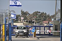 Golan ceasefire line crossing, 2012.
 -
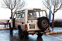 A UN Toyota Land Cruiser parked near Majdal Shams displaying UNDOF plates and a UN flag, January 2012.


UNDOF, the United Nations Disengagement Observer Force, was established in 1974 to supervise the implementation of the Agreement on Disengagement and maintain the ceasefire with an area of separation known as the UNDOF Zone. Currently there are more than 1,000 UN peacekeepers there trying to sustain a peace.[243] Syria and Israel still contest the ownership of the Heights but have not used overt military force since 1974.
The great strategic value of the Heights both militarily and as a source of water means that a deal is uncertain. Members of the UN Disengagement force are usually the only individuals who cross the Israeli–Syrian de facto border (cease fire "Alpha Line"), but since 1988 Israel has allowed Druze pilgrims to cross into Syria to visit the shrine of Abel on Mount Qasioun. Since 1967, Druze brides have been allowed to cross into Syria, although they do so in the knowledge that they may not be able to return.
Though the cease fire in the UNDOF zone has been largely uninterrupted since the seventies, in 2012 there were repeated violations from the Syrian side, including tanks[244] and live gunfire,[245] though these incidents are attributed to the ongoing Syrian Civil War rather than intentionally directed towards Israel.[246] On 15 October 2018 the Quneitra border crossing between the Golan Heights and Syria reopened for United Nations Disengagement Observer Force (UNDOF) personnel after four years of closure.[247]
Syrian villages


The population of the Golan Heights prior to the 1967 Six-Day War has been estimated between 130,000 and 145,000, including 17,000 Palestinian refugees registered with UNRWA.[248] Between 80,000[141] and 130,000[142] Syrians fled or were driven from the Heights during the Six-Day War and around 7,000 remained in the Israeli-held territory in six villages: Majdal Shams, Mas'ade, Buq'ata, Ein Qiniyye, Ghajar and Shayta.[142]
Israel forcibly expelled Syrians from the Golan Heights.[249][250] There were also instances of Israeli soldiers killing Syrian residents including blowing up their home with people inside.[251]
Israel demolished over one hundred Syrian villages and farms in the Golan Heights.[252][253] After the demolitions, the lands were given to Israeli settlers.[254]
Quneitra was the largest town in the Golan Heights until 1967, with a population of 27,000. It was occupied by Israel on the last day of the Six-Day War and handed back to Syrian civil control per the 1974 Disengagement Agreement. But the Israelis had destroyed Quneitra with dynamite and bulldozers before they withdrew from the city.[255][256]
East of the 1973 ceasefire line, in the Syrian controlled part of the Golan Heights, an area of 600 km2 (232 sq mi), are more than 40 Syrian towns and villages, including Quneitra, Khan Arnabah, al-Hamidiyah, al-Rafid, al-Samdaniyah, al-Mudariyah, Beer Ajam, Bariqa, Ghadir al-Bustan, Hader, Juba, Kodana, Ufaniyah, Ruwayhinah, Nabe' al-Sakhar, Trinjah, Umm al-A'zam, and Umm Batna. The population of the Quneitra Governorate numbers 79,000.[151]
Once annexing the Golan Heights in 1981, the Israeli government offered all non-Israelis living in the Golan citizenship, but until the early 21st century fewer than 10% of the Druze were Israeli citizens; the remainder held Syrian citizenship.[257] The Golan Alawites in the village of Ghajar accepted Israeli citizenship in 1981.[225] In 2012, due to the situation in Syria, young Druze have applied to Israeli citizenship in much larger numbers than in previous years.[258]
In 2012, there were 20,000 Druze with Syrian citizenship living in the Israeli-occupied portion Golan Heights.[259]


The Druze living in the Golan Heights are permanent residents of Israel. They hold laissez-passer documents issued by the Israeli government, and enjoy the country's social-welfare benefits.[260] The pro-Israeli Druze were historically ostracized by the pro-Syrian Druze.[261] Reluctance to accept citizenship also reflects fear of ill treatment or displacement by Syrian authorities should the Golan Heights eventually be returned to Syria.[262]
According to The Independent, most Druze in the Golan Heights live relatively comfortable lives in a freer society than they would have in Syria under Assad's government.[263] According to Egypt's Daily Star, their standard of living vastly surpasses that of their counterparts on the Syrian side of the border. Hence their fear of a return to Syria, though most of them identify themselves as Syrian,[264] but feel alienated from the "autocratic" government in Damascus. According to the Associated Press, "many young Druse have been quietly relieved at the failure of previous Syrian–Israeli peace talks to go forward."[227]
On the other hand, expressing pro-Syrian viewpoint, The Economist represents the Golan Druzes' view that by doing so they may be potentially rewarded by Syria, while simultaneously risking nothing in Israel's freewheeling society. The Economist likewise reported that "Some optimists see the future Golan as a sort of Hong Kong, continuing to enjoy the perks of Israel's dynamic economy and open society, while coming back under the sovereignty of a stricter, less developed Syria." The Druze are also reportedly well-educated and relatively prosperous, and have made use of Israel's universities.[265]
Since 1988, Druze clerics have been permitted to make annual religious pilgrimages to Syria. Since 2005, Israel has allowed Druze farmers to export some 11,000 tons of apples to the rest of Syria each year, constituting the first commercial relations between Syria and Israel.[227]
In the first years after the breakout of the Syrian Civil War in 2012, the number of applications for Israeli citizenship grew, although Syrian loyalty remained strong and those who applied for citizenship were often ostracized by members of the older generation.[266] In recent years, the number of applications for citizenship has increased, 239 in 2021 and 206 in the first half of 2022. In 2022, official Israeli figures suggest that of approximately 21,000 Druze living in the Golan Heights, about 4,300 (or around 20 percent) were Israeli citizens.[267]
-
 A demographic map of Quneitra Governorate (Golan Heights) before the 1967 six day war
 -
 A demographic map of Quneitra Governorate (Golan Heights) today. Excludes any permanent depopulation or repopulation that might have happened during the Syrian civil war
 -
 A demographic map of Quneitra Governorate (Golan Heights) overlaid with the location of the depopulated Syrian localities


Israeli settlements

Israeli settlement activity began in the 1970s. The area was governed by military administration until 1981 when Israel passed the Golan Heights Law, which extended Israeli law and administration throughout the territory.[21] This move was condemned by the United Nations Security Council in UN Resolution 497,[2][22] although Israel states it has a right to retain the area, citing the text of UN Resolution 242, adopted after the Six-Day War, which calls for "safe and recognised boundaries free from threats or acts of force".[198] The continued Israeli control of the Golan Heights remains controversial and is still regarded as an occupation by most countries other than Israel and the United States. Israeli settlements and human rights policy in the occupied territory have drawn criticism from the UN.[268][269]
The Israeli-occupied territory is administered by the Golan Regional Council, based in Katzrin, which has a population of 7,600. There are another 19 moshavim and 10 kibbutzim. In 1989, the Israeli settler population was 10,000.[270] By 2010 the Israeli settler population had expanded to 20,000[271] living in 32 settlements.[272][273] By 2019 it had expanded to 22,000.[274] In 2021, the Israeli settler population was estimated to be 25,000 with plans by the Government of Prime Minister Naftali Bennett to double that population over a five-year period.[5]
On 23 April 2019, Israel Prime Minister Benjamin Netanyahu announced that he would bring a resolution for government approval to name a new community in the Golan Heights after U.S. President Donald Trump.[275] The planned settlement was unveiled as Trump Heights on 16 June 2019.[276][277] Further plans for settlement expansion on the Golan were part of the agenda of Benjamin Netanyahu's incoming coalition in 2023.[278]
Geography

Geology

The plateau that Israel controls is part of a larger area of volcanic basalt fields stretching north and east that were created in the series of volcanic eruptions that began recently in geological terms, almost 4 million years ago.[279] The rock forming the mountainous area in the northern Golan Heights, descending from Mount Hermon, differs geologically from the volcanic rocks of the plateau and has a different physiography. The mountains are characterised by lighter-colored, Jurassic-age limestone of sedimentary origin. Locally, the limestone is broken by faults and solution channels to form a karst-like topography in which springs are common.
Geologically, the Golan plateau and the Hauran plain to the east constitute a Holocene volcanic field that also extends northeast almost to Damascus. Much of the area is scattered with dormant volcanos, as well as cinder cones, such as Majdal Shams. The plateau also contains a crater lake, called Birkat Ram ("Ram Pool"), which is fed by both surface runoff and underground springs. These volcanic areas are characterised by basalt bedrock and dark soils derived from its weathering. The basalt flows overlie older, distinctly lighter-colored limestones and marls, exposed along the Yarmouk River in the south.
Boundaries
The Golan Heights have distinct geographic boundaries.[279] On the north, the Sa'ar Stream (a tributary of Nahal Hermon/Nahr Baniyas) generally divides the lighter-colored limestone bedrock of Mount Hermon from the dark-colored volcanic rocks of the Golan plateau.[279] The western border of the plateau is truncated structurally by the Jordan Rift Valley, which falls down steeply into the Sea of Galilee (Lake Kinneret, Lake Tiberias).[279] The southern border is lined by the Yarmouk River, which separates the plateau from the northern region of Jordan.[279] Finally, the eastern edge of the Golan Heights is carved out by the Raqqad river (Wadi ar-Ruqqad), along which are stretching the areas still controlled by Syria.[279]
Size
The plateau's north–south length is approximately 65 km (40 mi) and its east–west width varies from 12 to 25 km (7.5 to 15.5 mi).[280][281]
Israel has captured, according to its own data, 1,150 km2 (440 sq mi).[282] According to Syria, the Golan Heights measures 1,860 km2 (718 sq mi), of which 1,500 km2 (580 sq mi) are occupied by Israel.[283] According to the CIA, Israel holds 1,300 km2 (500 sq mi).[284]
Topography

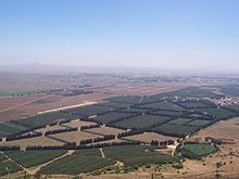
The area is hilly and elevated, overlooking the Jordan Rift Valley which contains the Sea of Galilee and the Jordan River, and is itself dominated by the 2,814 m (9,232 ft) tall Mount Hermon.[285][284] The Sea of Galilee at the southwest corner of the plateau[280] and the Yarmouk River to the south are at elevations well below sea level[284] (the sea of Galilee at about 200 m (660 ft)).[280]
Topographically, the Golan Heights is a plateau with an average altitude of 1,000 metres,[284] rising northwards toward Mount Hermon and sloping down to about 400 m (1,300 ft) elevation along the Yarmouk River in the south.[280] The steeper, more rugged topography is generally limited to the northern half, including the foothills of Mount Hermon; on the south the plateau is more level.[280]
There are several small peaks on the Golan Heights, most of them volcanic cones, such as: Mount Agas (1,350 m), Mount Dov/Jebel Rous (1,529 m; northern peak 1,524 m),[286] Mount Bental (1171 m) and opposite it Mount Avital (1204 m), Mount Ram (1188 m), Tal Saki (594 m).
Subdivisions
The broader Golan plateau exhibits a more subdued topography, generally ranging between 120 and 520 m (390 and 1,710 ft) in elevation. In Israel, the Golan plateau is divided into three regions: northern (between the Sa'ar and Jilabun valleys), central (between the Jilabun and Daliyot valleys), and southern (between the Daliyot and Yarmouk valleys). The Golan Heights is bordered on the west by a rock escarpment that drops 500 m (1,600 ft) to the Jordan River valley and the Sea of Galilee. In the south, the incised Yarmouk River valley marks the limits of the plateau and, east of the abandoned railroad bridge upstream of Hamat Gader and Al Hammah, it marks the recognised international border between Syria and Jordan.[287]
Climate and hydrology
In addition to its strategic military importance, the Golan Heights is an important water resource, especially at the higher elevations, which are snow-covered in the winter and help sustain baseflow for rivers and springs during the dry season. The Heights receive significantly more precipitation than the surrounding, lower-elevation areas. The occupied sector of the Golan Heights provides or controls a substantial portion of the water in the Jordan River watershed, which in turn provides a portion of Israel's water supply. The Golan Heights supplies 15% of Israel's water.[288]


Landmarks
The Golan Heights features numerous archeological sites, mountains, streams and waterfalls. Throughout the region 25 ancient synagogues have been found dating back to the Roman and Byzantine periods.[289][290]
- Banias (Arabic: بانياس الحولة; Hebrew: בניאס) is an ancient site that developed around a spring once associated with the Greek god Pan. Near the archaeological site is the Banias Waterfall, one of the most powerful waterfalls in the region, plunging about 10 meters into a pool surrounded by lush vegetation. Part of the stream is accessible via a 100-meter-long suspended walkway.[291]
- Deir Qeruh (Arabic: دير قروح; Hebrew: דיר קרוח) is a ruined Byzantine-period and Syrian village. Founded in the 4th century AD, it has a monastery and church of St George from the 6th century. The church has a square apse – a feature known from ancient Syria and Jordan, but not present in churches west of the Jordan River.[292]
- Kursi (Arabic: الكرسي; Hebrew: כורסי) is an archaeological site and national park on the shore of the Sea of Galilee at the foothills of the Golan, containing the ruins of a Byzantine Christian monastery connected to the Gospels (Gergesa).
- Katzrin (Arabic: قصرين; Hebrew: קצרין) is the administrative and commercial center of the Israeli-occupied Golan Heights. Katzrin Ancient Village is an archaeological site on the outskirts of Katzrin where the remains of a Talmud-era village and synagogue have been reconstructed.[293] The site has been described by an archeologist as being developed: "with a clear agenda and nationalistic narrative."[294] It has also been criticized for distorting historical items and showing a selective part of history, focusing on the Jewish period leaving out the Mamluk and Syrian periods.[295][296] Golan Archaeological Museum hosts archaeological finds uncovered in the Golan Heights from prehistoric times. A special focus concerns Gamla and excavations of synagogues and Byzantine churches.[297]

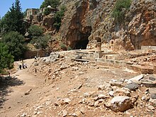
- Gamla Nature Reserve (Hebrew: שמורת טבע גמלא) is an open park with the archaeological remains of the ancient Jewish city of Gamla (Hebrew: גמלא, Arabic: جمالا) — including a tower, wall and synagogue. It is also the site of a large waterfall, an ancient Byzantine church, and a panoramic spot to observe the nearly 100 vultures that dwell in the cliffs. Israeli scientists study the vultures and tourists can watch them fly and nest.[298]
- A ski resort on the slopes of Mount Hermon (Arabic: جبل الشيخ; הר חרמון) features a wide range of ski trails and activities. Several restaurants are located in the area. The Lake Ram crater lake is nearby.

- Hippos (Arabic: قلعة الحصن; Hebrew: סוסיתא) is an ancient Greco-Roman city, known in Arabic as Qal'at al-Hisn and in Aramaic as Susita. The archaeological site includes excavations of the city's forum, the small imperial cult temple, a large Hellenistic temple compound, the Roman city gates, and two Byzantine churches.
- The Nimrod Fortress (Arabic: لعة الصبيبة; Hebrew: מבצר נמרוד) was built against the Crusaders, served the Ayyubids and Mamluks, and was captured only once, in 1260, by the Mongols. It is now located inside a nature reserve.

- Rujm el-Hiri (Arabic: رجم الهري; Hebrew: גלגל רפאים) is a large circular stone monument similar to Stonehenge. Excavations since 1968 have not uncovered material remains common to archaeological sites in the region. Archaeologists believe the site may have been a ritual center linked to a cult of the dead.[299] A 3D model of the site exists in the Museum of Golan Antiquities in Katzrin.
- Senaim (Arabic: جبل الحلاوة; Hebrew: הר סנאים) is an archaeological site in northern Golan Heights that includes both Roman and Ancient Greek temples. Byzantine and Mamluk coins have also been found at this site.
- Tell Hadar (Hebrew: תל הדר) is an Aramean archaeological site.
- Umm el-Qanatir (Arabic: ام القناطر; Hebrew: עין קשתות, Ein Keshatot) is another impressive set of standing ruins of a village of the Byzantine era. The site includes a very large synagogue and two arches next to a natural spring.[300]
Viticulture
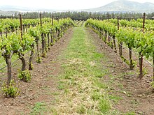
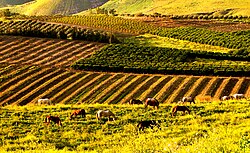
On a visit to Israel and the Golan Heights in 1972, Cornelius Ough, a professor of viticulture and oenology at the University of California, Davis, pronounced conditions in the Golan very suitable for the cultivation of wine grapes.[301] A consortium of four kibbutzim and four moshavim took up the challenge, clearing 250 burnt-out tanks in the Golan's Valley of Tears to plant vineyards for what would eventually become the Golan Heights Winery.[302] The first vines were planted in 1976, and the first wine was released by the winery in 1983.[301] The heights are now home to about a dozen wineries.[303]
Oil and gas exploration
In the early 1990s, the Israel National Oil Company (INOC) was granted shaft-sinking permits in the Golan Heights. It estimated a recovery potential of two million barrels of oil, equivalent at the time to $24 million. During the Yitzhak Rabin administration (1992–1995), the permits were suspended as efforts were undertaken to restart peace negotiations between Israel and Syria. In 1996, Benjamin Netanyahu granted preliminary approval to INOC to proceed with oil exploration drilling in the Golan.[304][305][306]
INOC began undergoing a process of privatization in 1997, overseen by then-Director of the Government Companies Authority (GCA), Tzipi Livni. During that time, it was decided that INOC's drilling permits would be returned to the state.[307][308] In 2012, National Infrastructure Minister Uzi Landau approved exploratory drilling for oil and natural gas in the Golan.[309] The following year, the Petroleum Council of Israel's Ministry of Energy and Water Resources secretly awarded a drilling license covering half the area of the Golan Heights to a local subsidiary of New Jersey-based Genie Energy Ltd. headed by Effi Eitam.[310][311]
Human rights groups have said that the drilling violates international law, as the Golan Heights are an occupied territory.[312]
On 18 November 2021, the United Nations Second Committee approved a draft resolution that demanded that: "Israel, the occupying Power, cease the exploitation, damage, cause of loss or depletion and endangerment of the natural resources in the Occupied Palestinian Territory, including East Jerusalem, and in the occupied Syrian Golan".[313][314]
See also
- Al-Marsad
- Borders of Israel
- Israeli-occupied territories
- Front for the Liberation of the Golan
- Golan Heights wind farm
- Golan Regional Council
- Golan Regiment, a Syrian para-military force
- Golani Brigade, a unit of the Israeli military
- Independent Israel–Syria peace initiatives
- International law and the Arab–Israeli conflict
- Israel–Syria relations
- Petroleum Road
- Shouting Hill
- Syrian towns and villages depopulated in the Arab–Israeli conflict
- UN Security Council Resolution 242
- UN Security Council Resolution 452
- UN Security Council Resolution 465
- UN Security Council Resolution 471
Explanatory notes
- ^ see Status of the Golan Heights
- ^ The United States recognized Israeli sovereignty over the Golan in March 2019. The US is the first country to recognize the Golan as Israeli territory, while the rest of the international community still considers it Syrian territory occupied by Israel.[3][4]
References
- ^ Jump up to: a b c *"The international community maintains that the Israeli decision to impose its laws, jurisdiction and administration in the occupied Syrian Golan is null and void and without international legal effect." International Labour Office (2009). The situation of workers of the occupied Arab territories (International government publication ed.). International Labour Office. p. 23. ISBN 978-92-2-120630-9.
- In 2008, a plenary session of the United Nations General Assembly voted by 161–1 in favour of a motion on the "occupied Syrian Golan" that reaffirmed support for UN Resolution 497. (General Assembly adopts broad range of texts, 26 in all, on recommendation of its fourth Committee, including on decolonization, information, Palestine refugees Archived 27 March 2019 at the Wayback Machine, United Nations, 5 December 2008.)
- "the Syrian Golan Heights territory, which Israel has occupied since 1967". Also, "the Golan Heights, a 450-square mile portion of southwestern Syria that Israel occupied during the 1967 Arab–Israeli war." (CRS Issue Brief for Congress: Syria: U.S. Relations and Bilateral Issues Archived 26 March 2019 at the Wayback Machine, Congressional Research Service. 19 January 2006)
- ^ Jump up to: a b c d e Korman, Sharon, The Right of Conquest: The Acquisition of Territory by Force in International Law and Practice, Oxford University Press, pp. 262–263
- ^ Trump signs decree recognizing Israeli sovereignty over Golan Heights, Reuters, 25 March 2019
- ^ Lee, Matthew; Riechmann, Deb (25 March 2019). "Trump signs declaration reversing US policy on Golan Heights". AP NEWS. Retrieved 27 March 2019.
- ^ Jump up to: a b "Israel approves plan to double settler population in Golan Heights". France 24. 26 December 2021.
- ^ "Israel to send 250,000 settlers to occupied Golan". www.aa.com.tr.
- ^ Statistical Abstract of Israel 2018, 2.17 Archived 20 November 2019 at the Wayback Machine. Israel Central Bureau of Statistics.
- ^ Golan Heights profile Archived 17 June 2019 at the Wayback Machine 25 March 2019 BBC
- ^ Tina Shepardson. Stones and Stories: Reconstructing the Christianization of the Golan, Archived 15 April 2001 at the Wayback Machine Biblisches Forum, 1999.
- ^ Kochavi, Moshe (1989). "The Land of Geshur Project: Regional Archaeology of the Southern Golan (1987–1988 Seasons)". Israel Exploration Journal. 39 (1/2): 3. ISSN 0021-2059. JSTOR 27926133.
- ^ Jump up to: a b Michael Avi-Yonah (1979). The Holy Land – from the Persian to the Arab Conquests (536 B.C. to A.D. 640) A Historical Geography, Grand Rapids, Michigan, p. 170 ISBN 978-0-8010-0010-2
- ^ Jump up to: a b HaReuveni, Immanuel (1999). Lexicon of the Land of Israel (in Hebrew). Miskal – Yedioth Ahronoth Books and Chemed Books. pp. 662–663 ISBN 978-965-448-413-8.
- ^ Jump up to: a b Vitto, Fanny, Ancient Synagogue at Rehov, Israel Antiquities Authority, Jerusalem 1974
- ^ Gevirtz, Gila (2008). Jewish History: The Big Picture. Behrman House, Inc. p. 25. ISBN 978-0-87441-838-5.
- ^ Avraham Negev; Shimon Gibson (2005). Archaeological Encyclopedia of the Holy Land (Paperback ed.). Continuum. p. 249. ISBN 978-0-8264-8571-7.
- ^ Jump up to: a b Syon, Danny (2014). Gamla III: The Shmarya Gutmann Excavations, 1976–1989. Finds and Studies (PDF). Vol. 1. Jerusalem: Israel Antiquities Authority Reports, No. 56. ISBN 978-965-406-503-0. p. 4 "Scholarly consensus holds that the Golan became populated by Jews following the conquests of Jannaeus in c. 80 BCE and as a direct result of these conquests."
- ^ Butcher, Kevin (2003). Roman Syria and the Near East. Getty Publications. ISBN 978-0-89236-715-3.
- ^ Michael J. Cohen (1989). The Origins and Evolution of the Arab-Zionist Conflict. University of California Press. p. 21. ISBN 978-0-520-90914-4.
- ^ The French Mandate in Syria, 1925–26, New York: Editorial Information Service of the Foreign Policy Association, 1925, retrieved 16 November 2020
- ^ "This Week in History: The Arab League Three No's". The Jerusalem Post. Retrieved 4 December 2017.
- ^ Jump up to: a b c d Golan Heights Law Archived 31 March 2019 at the Wayback Machine, MFA.
- ^ Jump up to: a b c "UN Security Council Resolution 497" (PDF). Archived (PDF) from the original on 31 March 2019. Retrieved 26 March 2019.
- ^ "Agreement on Disengagement between Israeli and Syrian Force". Report of the Secretary-General concerning the Agreement on Disengagement between Israeli and Syrian Forces. United Nations. Archived from the original on 21 April 2012. Retrieved 29 November 2011.
- ^ Jump up to: a b AP and TOI staff (31 July 2018). "Syria boots IS from Golan Heights, retaking full control of frontier with Israel". The Times of Israel. Retrieved 25 March 2019.
- ^ Jump up to: a b E. A. Myers (2010). The Ituraeans and the Roman Near East: Reassessing the Sources (Hardcover ed.). Cambridge University Press. p. 43. ISBN 978-0-521-51887-1.
- ^ "Ancient faiths embodied in ancient names: or, An attempt to trace the religious belief ... of certain nations", by Thomas Inman, 1872 History, page 551
- ^ Hastings, James (October 2004). A Dictionary of the Bible: Volume II: (Part I: Feign – Hyssop). The Minerva Group. ISBN 978-1-4102-1724-0.
- ^ Urman, Dan (1 January 1998), "Jews in the Golan—Historical Background", Ancient Synagogues, Volume 2, Brill, pp. 380–385, doi:10.1163/9789004532366_009, ISBN 978-90-04-53236-6, retrieved 10 September 2024
- ^ Jump up to: a b c Moshe Sharon (2004). Corpus inscriptionum Arabicarum Palaestinae. Brill Academic Publishers. p. 211. ISBN 978-90-04-13197-2.
- ^ John Lewis Burchhardt (1822). Travels in Syria and the Holy Land. Association for the promoting the discovery of the interior parts of Africa. p. 286.
- ^ Shahîd, Irfan (1995). Byzantium and the Arabs in the Sixth Century. Dumbarton Oaks. ISBN 978-0-88402-284-8.
- ^ "Venus of Berekhat Ram". visual-arts-cork.com.
- ^ Jump up to: a b c d e Kochavi, Moshe (1989). "The Land of Geshur Project: Regional Archaeology of the Southern Golan (1987–1988 Seasons)". Israel Exploration Journal. 39 (1/2): 3. ISSN 0021-2059. JSTOR 27926133.
- ^ Jump up to: a b c Zwickel, Wolfgang (25 March 2019), "Borders between Aram-Damascus and Israel: a Historical Investigation", Aramaean Borders, Brill, pp. 267–335, ISBN 978-90-04-39853-5, retrieved 10 June 2024
- ^ Jump up to: a b Na'aman, Nadav (2012). "The Kingdom of Geshur in History and Memory". Scandinavian Journal of the Old Testament. 26 (1): 92. doi:10.1080/09018328.2012.704198. ISSN 0901-8328. S2CID 73603495.
- ^ Richard 2003, p. 377
- ^ Ma'oz, Zvi Uri (1997). "Golan". The Oxford Encyclopedia of Archaeology in the Near East. p. 421. ISBN 978-0-19-511215-3.
- ^ Paturel, Simone Eid (25 June 2019), "From Hellenistic Kingdoms to Roman Authority in the Levant", Baalbek-Heliopolis, the Bekaa, and Berytus from 100 BCE to 400 CE, Brill, pp. 58–78, ISBN 978-90-04-40073-3, retrieved 3 June 2024
- ^ Eric M. Meyers (1996). The Oxford encyclopedia of archaeology in the Near East. Vol. 2 (Hardcover ed.). Oxford University Press. p. 421. ISBN 978-0-19-511216-0.
- ^ Richard 2003, p. 427
- ^ Sivan 2008, p. 98-99
- ^ Sivan 2008, p. 99
- ^ Jump up to: a b c d e f g Dauphin, Claudine M. (1982). "Jewish and Christian Communities in the Roman and Byzantine Gaulanitis : A Study of Evidence from Archaeological Surveys". Palestine Exploration Quarterly. 114 (2): 129–130, 132. doi:10.1179/peq.1982.114.2.129. ISSN 0031-0328.
- ^ Jump up to: a b Berlin, Andrea (2006). Gamla I: The Pottery of the Second Temple Period. Israel Antiquities Authority. pp. 153–154.
During the first century BCE, under Hasmonean encouragement, Judean Jews had moved north to Galilee and Gaulanitis. ... Meanwhile, between their protected spur in central Gaulanitis, the Hasmonean kingdom imploded and Herod rose to power. At his death in 4 BCE, two of his sons, Herod Philip and Herod Antipas, took over Gaulanitis and Galilee respectively.
- ^ Jump up to: a b c Chancey, Mark Alan; Porter, Adam Lowry (2001). "The Archaeology of Roman Palestine". Near Eastern Archaeology. 64 (4): 164–203. doi:10.2307/3210829. ISSN 1094-2076. JSTOR 3210829.
The Jewish presence probably dated back to the mid second century BCE, and most likely increased after the Hasmonean conquest of the region during the reign of Alexander Jannaeus. Itureans were among the earliest settlers in this period, having also arrived in the mid second century BCE, and ceramic evidence at numerous sites demonstrates that they continued to live there in the Roman Period. ... The initial Roman campaigns occurred in Galilee and adjacent parts of the Golan, and military activities are visible in the archaeological records of several sites. Though Gamala initially remained loyal to Agrippa II in the Jewish Revolt, it ultimately chose to rebel. Wartime coins unique to the city bear the Hebrew inscription "for the redemption of H[oly] Jerusalem" (Syon 1992/93). The town, surrounded by steep ravines, repelled assaults by the loyalist forces of Agrippa but could not withstand the protracted siege by Roman troops that followed. Josephus described the battle in epic terms: to escape capture, "multitudes plunged headlong with their wives and children into the ravine which had been excavated to a vast depth beneath the citadel" (War 4.80). The Roman breach of the wall by the synagogue is still visible today, and fortress walls, remains of towers, pieces of armor, arrowheads, sling stones, ballista stones, and traces of fire attest to the ferocity of the siege.
- ^ Josephus, The Jewish War 1.20.3 Archived 25 February 2021 at the Wayback Machine–4 Archived 27 February 2021 at the Wayback Machine
- ^ Syon, Danny, and ZVI YAVOR. "Gamla." Portrait of a Rebellion. BAR 18 (1992): 20–37.
- ^ Richardson, Peter (1 January 2004), "Pre-70 Synagogues as Collegia in Rome, the Diaspora, and Judea", Building Jewish in the Roman East, Brill, p. 126, doi:10.1163/9789047406501_012, ISBN 978-90-474-0650-1, retrieved 3 April 2024
- ^ Syon, Danny. "Gamala." Archived 19 October 2020 at the Wayback Machine. The Encyclopedia of Ancient History (2013).
- ^ Jump up to: a b Rogers, Guy MacLean (2021). For the Freedom of Zion: the Great Revolt of Jews against Romans, 66-74 CE. New Haven: Yale University Press. pp. 189, 249. ISBN 978-0-300-24813-5.
- ^ Gregg, Robert C (September 2000). "Marking religious and ethnic boundaries: cases from the ancient Golan Heights". Church History. 69 (3): 519–557, 39. doi:10.2307/3169396. JSTOR 3169396.
- ^ Shahîd, Irfan (1995). Byzantium and the Arabs in the Sixth Century. Dumbarton Oaks. ISBN 978-0-88402-284-8.
- ^ Moshe Sharon (2004). Corpus inscriptionum Arabicarum Palaestinae. Brill Academic Publishers. p. 211. ISBN 978-90-04-13197-2.
- ^ "The Edinburgh New Philosophical Journal". Google News. 1860.
- ^ Jump up to: a b c Urman, Dan (1 January 1998), "Jews in the Golan—Historical Background", Ancient Synagogues, Volume 2, Brill, pp. 380–385, doi:10.1163/9789004532366_009, ISBN 978-90-04-53236-6, retrieved 10 September 2024
- ^ Schuster, Ruth (3 June 2024). "Unknown Roman road cutting through Golan Heights is revealed in northern Israel". Haaretz. Retrieved 3 June 2024.
- ^ Jump up to: a b Maʿoz, Zvi Uri (1 June 1988). "Ancient Synagogues of the Golan". The Biblical Archaeologist. 51 (2): 116–128. doi:10.2307/3210031. ISSN 0006-0895. JSTOR 3210031. S2CID 134351479.
- ^ Lieberman, Saul (1931). The Talmud of Caesarea (in Hebrew). Vol. 2. Supplement to Tarbiz. p. 9.
- ^ Jump up to: a b c d Dauphin, Claudine M. (1982). "Jewish and Christian Communities in the Roman and Byzantine Gaulanitis : A Study of Evidence from Archaeological Surveys". Palestine Exploration Quarterly. 114 (2): 129–130, 132. doi:10.1179/peq.1982.114.2.129. ISSN 0031-0328.
- ^ UNESCO (31 December 2011). The different aspects of islamic culture: The Spread of Islam throughout the World. UNESCO Publishing. ISBN 978-92-3-104153-2.
- ^ Frassetto, Michael (12 November 2019). Christians and Muslims in the Middle Ages: From Muhammad to Dante. Rowman & Littlefield. ISBN 978-1-4985-7757-1.
- ^ Jump up to: a b Dauphin, Claudine M. (1982). "Jewish and Christian Communities in the Roman and Byzantine Gaulanitis : A Study of Evidence from Archaeological Surveys". Palestine Exploration Quarterly. 114 (2): 129–130, 132. doi:10.1179/peq.1982.114.2.129. ISSN 0031-0328.
- ^ Lammens, H., (1913). 'Djabiya', in The Encyclopaedia of Islam, Vol. I, Cols pp. 988-89
- ^ Buhl, F., (1913) 'Al-Djawlan', in The Encyclopaedia of Islam, Vol. I, A-D, Cols pp. 1029-30
- ^ Shahîd 1995, pp. 33, 48–49.
- ^ Sivan 2008, p. 99: "The transfer of the Ghassanid to the Golan tipped credal and ethnic balance in favour of Christianity and Arabs."
- ^ Sivan 2008, p. 102
- ^ Sivan 2008, p. 99
- ^ Shaid 1995, p. 527
- ^ Decker, Michael (1 July 2009). "The Vine". Tilling the Hateful Earth. Oxford University Press. pp. 136, 235. doi:10.1093/acprof:oso/9780199565283.003.0005. ISBN 978-0-19-956528-3.
- ^ Maʿoz, Zvi Uri (1 June 1988). "Ancient Synagogues of the Golan". The Biblical Archaeologist. 51 (2): 116–128. doi:10.2307/3210031. ISSN 0006-0895. JSTOR 3210031. S2CID 134351479.
- ^ Jerome Murphy-O'Connor (2008). The Holy Land: An Oxford Archaeological Guide from Earliest Times to 1700. Oxford Archaeological Guides. Oxford: Oxford University Press. pp. 289–290. ISBN 978-0-19-923666-4. Retrieved 12 July 2018.
- ^ Kaegi, Gottlieb. Benezit Dictionary of Artists. Oxford University Press. 31 October 2011. doi:10.1093/benz/9780199773787.article.b00096658.
- ^ Maʿoz, Zvi Uri (1 June 1988). "Ancient Synagogues of the Golan". The Biblical Archaeologist. 51 (2): 116–128. doi:10.2307/3210031. ISSN 0006-0895. JSTOR 3210031. S2CID 134351479.
- ^ Maʿoz, Zvi Uri (1 June 1988). "Ancient Synagogues of the Golan". The Biblical Archaeologist. 51 (2): 116–128. doi:10.2307/3210031. ISSN 0006-0895. JSTOR 3210031. S2CID 134351479.
- ^ Jump up to: a b Ellenblum, R. Frankish Rural Settlement in the Latin Kingdom of Jerusalem Archived 14 December 2022 at the Wayback Machine, Cambridge University Press, 2003. pg. 219-20. ISBN 978-0-521-52187-1
- ^ "Utexas.edu".
- ^ "UMN.edu". Archived from the original on 15 February 2010. Retrieved 11 February 2010.
- ^ Denys Pringle (2009). Secular Buildings in the Crusader Kingdom of Jerusalem: An Archaeological Gazetteer. Cambridge University Press. p. 30. ISBN 978-0-521-10263-6. Retrieved 4 May 2015.
- ^ ‘Abbasi & Seltenreich 2007, pp. 25
- ^ ‘Abbasi & Seltenreich 2007, pp. 25
- ^ ‘Abbasi & Seltenreich 2007, pp. 25
- ^ ‘Abbasi & Seltenreich 2007, pp. 26
- ^ ‘Abbasi & Seltenreich 2007, pp. 26
- ^ ‘Abbasi & Seltenreich 2007, pp. 26
- ^ ‘Abbasi & Seltenreich 2007, pp. 27
- ^ ‘Abbasi & Seltenreich 2007, pp. 27
- ^ ‘Abbasi & Seltenreich 2007, pp. 25
- ^ "Peace conference: memoranda respecting Syria, Arabia and Palestine". Retrieved 6 January 2023.
- ^ Shoup, John A. (2007). Culture and customs of Jordan. Culture and customs of the Middle East. Greenwood Publishing Group. p. 31. ISBN 978-0-313-33671-3. Retrieved 18 January 2020.
- ^ Porter, Josias Leslie. A handbook for travellers in Syria and Palestine Archived 14 December 2022 at the Wayback Machine, J. Murray, 1868. pg. 439. [Harvard University, 4 January 2007]
- ^ The Caspian Region: The Caucasus Archived 14 December 2022 at the Wayback Machine, M. Gammer, pg. 64.
- ^ Gudrun Krämer. A history of Palestine: from the Ottoman conquest to the founding of the state of Israel, Princeton University Press, 2008. pg.137. ISBN 978-0-691-11897-0
- ^ David Dean Commins. Historical dictionary of Syria Archived 14 December 2022 at the Wayback Machine, pg. 77.
- ^ Schumacher (1888), pp. 1–304
- ^ Schumacher, Gottlieb (1888). "Map of the Jaulan by Gottlieb Schumacher, C. E. 1885 / Edwd. Weller. lith". London: Richard Bentley and Son. Retrieved 5 October 2020.
- ^ Schumacher (1888), pp. 42–61
- ^ Martha Mundy, Basim Musallam. The transformation of nomadic society in the Arab East Archived 14 December 2022 at the Wayback Machine, Cambridge University Press, 2000. pg. 40. ISBN 978-0-521-77057-6,
- ^ Jump up to: a b Kats, Yosef. The "business" of settlement: private entrepreneurship in the Jewish settlement of Palestine, 1900–1914 Archived 14 December 2022 at the Wayback Machine, Magnes Press, Hebrew University, 1994. p. 20. ISBN 978-965-223-863-4.
- ^ A hundred years of settlement, Keter, 1985. pg. 200.
- ^ Jump up to: a b c d e Separation of Trans-Jordan from Palestine, Yitzhak Gil-Har, The Jerusalem Cathedra, ed. Lee Levine, Yad Yitzhak Ben Zvi and Wayne State University, Jerusalem, 1981, p.306
- ^ Sicker, Martin (1999). Reshaping Palestine. Greenwood Publishing. ISBN 978-0-275-96639-3.
- ^ Jump up to: a b c d M. R. Fishbach, Jewish property claims against Arab countries, Columbia University Press (2008), pp36-37.
- ^ Aharonson, Ran. Rothschild and early Jewish colonization in Palestine Archived 14 December 2022 at the Wayback Machine, Rowman & Littlefield, 2000. pg. 98. ISBN 978-0-7425-0914-6
- ^ Efraim Orni, Elisha Efrat. Geography of Israel Archived 18 January 2016 at the Wayback Machine, Israel Universities Press, 1971.
- ^ Efraim Orni, Elisha Efrat. Geography of Israel Archived 18 January 2016 at the Wayback Machine, Israel Universities Press, 1971.
- ^ Military government in the territories administered by Israel, 1967–1980 Archived 18 January 2016 at the Wayback Machine, Hebrew University Jerusalem, Faculty of Law, Harry Sacher Institute for Legislature Research and Comparative Law, 1982, p.102.
- ^ Jewish spectator Archived 14 December 2022 at the Wayback Machine, Volume 60, 1995.
- ^ Biger, 2005, p. 173.
- ^ Chaim Weizmann, subsequently reported to his colleagues in London: "There are still important details outstanding, such as the actual terms of the mandate and the question of the boundaries in Palestine. There is the delimitation of the boundary between French Syria and Palestine, which will constitute the northern frontier and the eastern line of demarcation, adjoining Arab Syria. The latter is not likely to be fixed until the Emir Faisal attends the Peace Conference, probably in Paris." See: 'Zionist Aspirations: Dr Weizmann on the Future of Palestine', The Times, Saturday, 8 May 1920; p. 15.
- ^ Jump up to: a b Franco-British Convention on Certain Points Connected with the Mandates for Syria and the Lebanon, Palestine and Mesopotamia, signed 23 December 1920. Text available in American Journal of International Law, Vol. 16, No. 3, 1922, 122–126.
- ^ Agreement between His Majesty's Government and the French Government respecting the Boundary Line between Syria and Palestine from the Mediterranean to El Hámmé, Treaty Series No. 13 (1923), Cmd. 1910. Also Louis, 1969, p. 90.
- ^ FSU Law Archived 16 September 2006 at the Wayback Machine.
- ^ Jump up to: a b c Robert G. Rabil (2003). Embattled neighbors: Syria, Israel, and Lebanon. Lynne Rienner Publishers. pp. 15–16. ISBN 978-1-58826-149-6.
- ^ Jump up to: a b The Brink of Peace: The Israeli–Syrian Negotiations By Itamar Rabinovich, page 19
- ^ Finkelstein 2003, pp. 131, 132, 186
- ^ Finkelstein 2003, pp. 133
- ^ Finkelstein 2003, pp. 133
- ^ The UNRWA commissioned a plan for the development of the Jordan River; this became widely known as "The Johnston plan". The plan was modelled on the Tennessee Valley Authority development plan for the development of the Jordan River as a single unit. Greg Shapland, (1997) Rivers of Discord: International Water Disputes in the Middle East Archived 14 December 2022 at the Wayback Machine, C. Hurst & Co. Publishers, ISBN 978-1-85065-214-4 p. 14
- ^ Sosland, Jeffrey (2007) Cooperating Rivals: The Riparian Politics of the Jordan River Basin Archived 14 December 2022 at the Wayback Machine, SUNY Press, ISBN 978-0-7914-7201-9 p. 70
- ^ Moshe Gat (2003). Britain and the Conflict in the Middle East, 1964–1967: The Coming of the Six-Day War. Greenwood Publishing Group. p. 101. ISBN 978-0-275-97514-2. Retrieved 7 September 2013.
[on 1965] "Nasser too, assured the American under Secretary of state, Philip Talbot, that the Arabs would not exceed the water quotas prescribed by the Johnston plan"
- ^ Avi Shlaim (2000). The Iron Wall: Israel and the Arab World. Penguin Books. pp. 229, 230. ISBN 978-0-14-028870-4.
In January 1964 an Arab League summit meeting convened in Cairo. The main item on the agenda was the threat posed by Israel's diversion of water … The preamble to its decision stated: "The establishment of Israel is the basic threat that the Arab nation in its entirety has agreed to forestall. And Since the existence of Israel is a danger that threatens the Arab nation, the diversion of the Jordan waters by it multiplies the dangers to Arab existence. Accordingly, the Arab states have to prepare the plans necessary for dealing with the political, economic and social aspects, so that if necessary results are not achieved, collective Arab military preparations, when they are not completed, will constitute the ultimate practical means for the final liquidation of Israel
- ^ Masahiro Murakami (1995). Managing Water for Peace in the Middle East; Alternative Strategies. United Nations University Press. pp. 287–297. ISBN 978-92-808-0858-2.
- ^ Finkelstein 2003, pp. 132
- ^ M. Shemesh, Prelude to the Six-Day War: The Arab–Israeli Struggle Over Water Resources, Israel Studies, vol 9, no. 3, 2004.
- ^ Jump up to: a b M. Shemesh, The Fida'iyyun Organization's Contribution to the Descent to the Six-Day War, Israel Studies, vol 11, no. 1, 2006.
- ^ M. Shemesh, The IDF Raid On Samu: The Turning-Point In Jordan's Relations With Israel and the West Bank Palestinians, Israel Studies, vol 7, no. 1, 2002.
- ^ "Six-Day War", Microsoft Encarta Online Encyclopedia 2007. Archived 31 October 2009.
- ^ Finkelstein 2003, pp. 132
- ^ Sicker, Martin, Israel's quest for security, New York. Praeger Publishing (1989), p. 92–95
- ^ Eban, Abba, Abba Eban. An Autobiography, New York: Random House (1977) p. 313-314
- ^ Gilbert, Martin, The Arab–Israeli Conflict: Its History in Maps, 4th ed, London: Weidenfeld and Nicolson (1985) p 63–64
- ^ Finkelstein 2003, pp. 132
- ^ Washington Report on Middle East Affairs Archived 29 October 2005 at the Wayback Machine, 1991-11.
- ^ Schmemann, Serge (11 May 1997). "General's Words Shed a New Light on the Golan". The New York Times. Retrieved 3 May 2010.
- ^ Embattled neighbors: Syria, Israel, and Lebanon, By Robert G Rabil, p.15-16. Archived 14 December 2022 at the Wayback Machine, They followed to a great extent a pattern of action and reaction. Israel would move tractors and equipment, often guarded by police, into disputed areas of the DMZ. From its high ground positions. Syria would fire at those advancing, and would frequently shell Israeli settlements in the Huleh Valley. Israel would retaliate with excessive raids on Syrian positions, including the use of air power.
- ^ Murray, Douglas J.; Viotti, Paul R. (1994). The Defense Policies of Nations. JHU Press. ISBN 978-0-8018-4794-3.
- ^ *"Andere kijk op Zesdaagse Oorlog". Novatv. 4 June 2007. Archived from the original on 6 July 2015. Retrieved 12 April 2015."Six-Day War deliberately provoked by Israel: former Dutch UN observer". DeepJournal. 8 June 2007.
- ^ Embattled neighbors: Syria, Israel, and Lebanon, By Robert G Rabil, p. 15, "UN officials found fault with the policies of both Israel and Syria and often accused the 2 countries of destabilizing the Israeli–Syrian borders".
- ^ Robert Slater. Warrior Statesman: The Life of Moshe Dayan, Robson Books, London (1992), pg. 277.
- ^ Jump up to: a b Morris (2001), p. 327: "Another eighty to ninety thousand civilians fled or were driven from the Golan Heights."
- ^ Jump up to: a b c d The Arab Centre for Human Rights in the Golan Heights: NGO Report Archived 3 April 2019 at the Wayback Machine, pg. 3. 25 January 2007. 90,000 according to Israeli sources and 115,000 according to Syrian sources, which included 17,000 Palestinian refugees registered with UNRWA, cited in the Report of the Secretary-General under General Assembly resolution 2252 (ES-V) and Security Council resolution 237 (1967 Archived 2 October 2013 at the Wayback Machine, pg. 14. 15 September 1967.)
- ^ "Different accounts on whether Golan inhabitants were expelled or whether they fled (1997–2002)". Archived from the original on 27 September 2007. Retrieved 18 July 2007.
- ^ "A View From Damascus: Internal Refugees From Golan's 244 Destroyed Syrian Villages". Washington-report.org. Retrieved 26 March 2013.
- ^ Golan Facts Archived 21 August 2006 at the Wayback Machine.
- ^ Dunstan, Simon (2009). The Six Day War 1967: Jordan and Syria. Osprey. ISBN 978-1-84603-364-3.[permanent dead link]
- ^ Herzog, Chaim, The Arab Israeli Wars, New York: Random House (1982) p.190-191
- ^ Eldar, Akiva. A matter of a few dozen meters Archived 22 November 2008 at the Wayback Machine, Haaretz, 1 June 2008.
- ^ Isachenkov, Vladimir (11 July 2018). "Putin and Netanyahu meet for Syria-focused talks in Moscow". Associated Press. Archived from the original on 12 July 2018. Retrieved 12 July 2018.
- ^ The Middle East and North Africa 2003, Occupied Territories, The Golan Heights, page 604.
- ^ Jump up to: a b "الوكالة العربية السورية للأنباء". sana.sy. Archived from the original on 25 February 2009.
- ^ Landmine monitor report Archived 14 December 2022 at the Wayback Machine, International Campaign to Ban Landmines, pg. 696. ISBN 978-1-56432-287-6.
- ^ Marshall, Edgar S. Israel: current issues and historical background Archived 22 October 2022 at the Wayback Machine, Nova Publishers, 2002. pg. 34. ISBN 978-1-59033-325-9.
- ^ United Nations. Security Council Resolutions Archived 14 August 2018 at the Wayback Machine, 1981.
- ^ Council on Foreign Relations. UN Security Council Resolution 497 Archived 28 June 2019 at the Wayback Machine,
- ^ "Document 487". Foreign Relations of the United States, 1964–1968, Volume XIX, Arab–Israeli Crisis and War. U.S. State Department. Retrieved 26 October 2010.
- ^ (Baron) Caradon, Hugh Foot (1981). U.N. Security Council Resolution 242: A Case Study in Diplomatic Ambiguity. Institute for the Study of Diplomacy, Edmund A. Walsh School of Foreign Service, Georgetown University. p. 12. ISBN 978-0-934742-11-5.
- ^ Jump up to: a b Taylor & Francis Group (2003). The Europa World Year Book 2003. Europa World Yearbook. Routledge. p. 2217. ISBN 978-1-85743-227-5. Retrieved 19 March 2019.
- ^ The Christian Science Monitor (28 September 2009). "Yearning for the Golan Heights: why Syria wants it back". The Christian Science Monitor. Retrieved 19 March 2019.
- ^ Castellino, Joshua; Cavanaugh, Kathleen (2013). Minority Rights in the Middle East. OUP Oxford. p. 132. ISBN 978-0-19-967949-2. Retrieved 19 March 2019.
- ^ Kipnis, Yigal (2013). The Golan Heights: Political History, Settlement and Geography since 1949. Routledge Studies in Middle Eastern Politics. Taylor & Francis. pp. 130–144. ISBN 978-1-136-74092-3. Retrieved 19 March 2019.
- ^ Rasgon, Adam. "Golan Druze communities set for first municipal elections — and many are fuming". The Times of Israel. Retrieved 17 June 2019.
- ^ "More Shadows than Lights–Local Elections in the Occupied Syrian Golan" (PDF). Al-Marsad. Retrieved 16 June 2019.
- ^ "Druze on Golan Heights protest against Israeli municipal election". Reuters. 30 October 2018. Retrieved 17 June 2019.
- ^ Mraffko, Clothilde. "For many Golan Druze, voting in first-ever municipal election remains taboo". The Times of Israel. Retrieved 17 June 2019.
- ^ Mackie, Kyle S. (6 September 2018). "An Experiment in Democracy: Torn Between Syria and Israel, Golan Druze Divided Over First Election". Haaretz. Retrieved 17 June 2019.
- ^ Jump up to: a b Moshe Ma'oz (March 2005). "Can Israel and Syria Reach Peace?: Obstacles, Lessons, and Prospects" (PDF). Archived from the original (PDF) on 12 September 2007. Retrieved 6 April 2008.
- ^ Ross, Missing Peace, 589
- ^ Clinton, My Life 883-88,903
- ^ "Olmert to Assad: Israel willing to withdraw from Golan Heights". Ynetnews. Ynet News. 8 June 2007. Retrieved 8 June 2007.
- ^ "Hafez Assad conceded Mt Hermon, says Netanyahu". Ynetnews. Ynet News. 8 June 2007. Retrieved 8 June 2007.
- ^ "BBC NEWS – Middle East – Israel 'ready to return Golan'". BBC. 23 April 2008.
- ^ Nahmias, Roee. "Syrian report: Olmert agreed to concede Golan Heights". Ynet. Retrieved 23 April 2008.
- ^ Einav, Hagai. "Attempt to cede Golan doomed to fail, say local leaders". Ynet. Retrieved 24 April 2008.
- ^ "Poll: 70% oppose relinquishing Golan Heights". The Jerusalem Post. 21 May 2008.
- ^ General Assembly adopts broad range of texts, 26 in all, on recommendation of its fourth Committee, including on decolonization, information, Palestine refugees Archived 28 June 2011 at the Wayback Machine, United Nations, 5 December 2008
- ^ Nahmias, Roee (20 June 1995). "Report: Israel asked to resume Syria talks – Israel News, Ynetnews". Ynetnews. Ynetnews.com. Retrieved 26 March 2013.
- ^ "חדשות, ידיעות מהארץ והעולם – עיתון הארץ". הארץ.[permanent dead link]
- ^ Barak Ravid (8 May 2009). "Netanyahu: Israel will never withdraw from Golan". Haaretz.
- ^ "JTA, Netanyahu: Golan ours forever, August 1, 2007". Archived from the original on 31 May 2012.
- ^ Indyk, Martin (2009). Innocent Abroad: An Intimate Account of American Peace Diplomacy in the Middle East. Simon & Schuster.
- ^ "Assad: Golan issue non-negotiable – Israel News, Ynetnews". Ynetnews. Ynetnews.com. 20 June 1995. Retrieved 26 March 2013.
- ^ Sofer, Roni (20 June 1995). "Peres: Assad can't have both Golan and Hezbollah – Israel News, Ynetnews". Ynetnews. Ynetnews.com. Retrieved 26 March 2013.
- ^ "Syrian FM in response to Peres: Golan Heights belongs to us – Israel News, Ynetnews". Ynetnews. Ynetnews.com. 20 June 1995. Retrieved 26 March 2013.
- ^ "Israel's Lieberman cautions Syria". Al Jazeera. 4 February 2010. Retrieved 8 April 2011.
'We must make Syria recognise that just as it relinquished its dream of a greater Syria that controls Lebanon ... it will have to relinquish its ultimate demand regarding the Golan Heights,' Lieberman said.
- ^ Rudoren, Jodi (2 October 2015). "As Syria Reels, Israel Looks to Expand Settlements in Golan Heights". The New York Times. Retrieved 16 December 2015.
- ^ "White House Official: U.S. Won't Recognize Israeli Sovereignty in Golan". Haaretz. Retrieved 16 December 2015.
- ^ Chloe, Farand (28 August 2017). "Isis fighters 'attacked Israel Defense Forces unit, then apologised' claims former commander". The Independent. Retrieved 14 January 2023.
- ^ Loveday Morris (10 May 2018). "Iranian forces fire rockets at Israeli military in first direct attack ever, Israel's army says". The Washington Post.
- ^ "Golan Druze rally in support of Syria's Assad". France24. 17 April 2018.
- ^ "Druze in Israel's Golan Heights rally in support of Syria's Assad". Times of Israel. 17 April 2018.
- ^ "Hezbollah rockets spark fires burning 10,000 dunams of open areas in north". Times of Israel. 3 June 2024. Retrieved 4 June 2024.
- ^ "Israel says Hezbollah rocket kills 12 at football ground, vows response". Reuters. 28 July 2024. Retrieved 1 August 2024.
- ^ "Druze in shock as war between Israel and Hezbollah strikes home". Reuters. 29 July 2024. Retrieved 1 August 2024.
- ^ Jump up to: a b Edgar S. Marshall. Israel: current issues and historical background. Nova Publishers, 2002. pg. 35. ISBN 978-1-59033-325-9.
- ^ Garfinkle, Adam (1998). "History and Peace: Revisiting two Zionist myths". Israel Affairs. 5 (1). Routledge: 135–146. doi:10.1080/13537129808719501.
- ^ Ebrahim, Nadeen (28 July 2024). "What is the Golan Heights and who are the Druze?". CNN. Retrieved 30 July 2024.
- ^ Jump up to: a b Y.Z Blum "Secure Boundaries and Middle East Peace in the Light of International Law and Practice" (1971) pages 24–46
- ^ Jump up to: a b c "The Line of June 4, 1967". jewishvirtuallibrary.org.
- ^ A. Garfinkle, History and Peace: Revisiting two Zionist myths, Israel Affairs, vol. 5 (1998) pp126–148.
- ^ "Israel-Syria Armistice Agreement (1949) | Jewish Virtual Library". www.jewishvirtuallibrary.org.
- ^ Kaufman (2013), p72.
- ^ "Israel, Hezbollah exchange fire, raising regional tensions". AlJazerra. 8 October 2023.
- ^ The Syrian official news agency SANA routinely calls the Shebaa Farms Lebanese. [1].
- ^ Kaufman (2013), p26.
- ^ File:Carte_du_Liban_d'apres_les_reconnaissances_de_la_Brigade_Topographique_du_Corps_Expeditionnaire_de_Syrie_en_1860-1861.jpg
- ^ Kaufman (2013), p35.
- ^ Jump up to: a b Kaufman (2013), p36.
- ^ Jump up to: a b c d Kaufman (2013), pp37-41.
- ^ Kaufman, Asher (2004). "Understanding the Sheeba Farms dispute". Palestine-Israel Journal. 11 (1). Retrieved 22 July 2006.
- ^ Jump up to: a b c "Border problems. Lebanon, UNIFIL and Italian participation by Lucrezia Gwinnett Liguori" (PDF). Archived from the original (PDF) on 10 October 2017. Retrieved 2 September 2010.
- ^ Kaufman, Asher (2004). "Understanding the Shebaa Farms dispute". Palestine-Israel Journal. 11 (1). Retrieved 22 July 2006.
- ^ Jump up to: a b Kaufman (2013), pp171–173.
- ^ Kaufman (2013), pp175–176.
- ^ Timur Goksel, a spokesman for the United Nations Interim Force in Lebanon (UNIFIL) stated: "The UN is saying that on all maps the UN has been able to find, the farms are seen on the Syrian side." "In focus: Shebaa farms". BBC News. 25 May 2000. Retrieved 29 September 2006.
- ^ Selim Tadmoury, Ambassador of Lebanon to the UN. "A/54/870–S/2000/443 Letter dated 15 May 2000 from the Permanent Representative of Lebanon to the United Nations addressed to the Secretary-General". Retrieved 6 August 2024.
- ^ Jump up to: a b "Security council endorses secretary-general's conclusion on Israeli withdrawal from Lebanon as of June 16". United Nations Security Council. 18 June 2000. Archived from the original on 19 February 2004.
- ^ Jump up to: a b United Nations (31 May 2023). "UNIFIL Press Kit" (PDF). Retrieved 7 August 2023.
- ^ Kaufman (2013), p212.
- ^ Kaufman (2013) p212.
- ^ United Nations Security Council. "Resolution 1701 (2006), S/RES/1701".
- ^ United Nations Security Council (30 October 2007). "S/2007/641 : Report of the Secretary-General on the implementation of Security Council resolution 1701 (2006)". Retrieved 6 August 2024.
- ^ United Nations Security Council (16 November 2023). "S/2023/879 Implementation of Security Council resolution 1701 (2006) during the period from 21 June to 20 October 2023 : Report of the Secretary-General".
- ^ Israeli Ministry of Foreign Affairs (4 August 2000). "The legal status of the Shebaa Farms". Retrieved 6 August 2014.
- ^ Jump up to: a b Ghajar says `don't fence me in' Archived 1 October 2007 at the Wayback Machine
- ^ UNIFIL Press Kit Archived 14 August 2021 at the Wayback Machine p.6
- ^ Jump up to: a b c Golan's Druse Wary of Israel and Syria Archived 11 October 2017 at the Wayback Machine 3 June 2007
- ^ "Trump's Golan move unites Gulf States and Iran in condemnation". France 24. 26 March 2019. Retrieved 31 March 2019.
- ^ Roberts, Adam (January 1990). "Prolonged Military Occupation: The Israeli-Occupied Territories Since 1967". American Journal of International Law. 84 (1): 60. doi:10.2307/2203016. JSTOR 2203016. S2CID 145514740.
- ^ Korman, Sharon (31 October 1996), The Right of Conquest: The Acquisition of Territory by Force in International Law and Practice, Oxford University Press, pp. 262–264, ISBN 978-0-19-158380-3
- ^ Occupied territory:
- "Israeli-occupied Golan Heights" (Central Intelligence Agency. CIA World Factbook 2010, Skyhorse Publishing Inc., 2009. pg. 339. ISBN 978-1-60239-727-9.)
- "...the United States considers the Golan Heights to be occupied territory subject to negotiation and Israeli withdrawal..." ("CRS Issue Brief for Congress: Israeli–United States Relations" Archived 24 April 2003 at the Wayback Machine, Congressional Research Service, 5 April 2002. pg. 5. Retrieved 1 August 2010.)
- "Occupied Golan Heights" (Travel advice: Israel and the Occupied Palestinian Territories Archived 20 July 2009 at the Wayback Machine, UK Foreign and Commonwealth Office. Retrieved 1 August 2010.)
- "In the ICRC's view, the Golan is an occupied territory." (ICRC activities in the occupied Golan during 2007 Archived 15 February 2021 at the Wayback Machine, International Committee of the Red Cross, 24 April 2008.)
- ^ Trump, Donald J. (25 March 2019). "Proclamation on Recognizing the Golan Heights as Part of the State of Israel". whitehouse.gov. Retrieved 25 March 2019 – via National Archives.
- ^ Landler, Mark; Halbfinger, David M. (25 March 2019). "Trump, With Netanyahu, Formally Recognizes Israel's Authority Over Golan Heights". The New York Times. ISSN 0362-4331. Retrieved 25 March 2019.
- ^ Wilner, Michael (28 February 2019). "GOP lawmakers introduce bill recognizing Israeli sovereignty over Golan". The Jerusalem Post. Retrieved 1 August 2024.
- ^ Noa Landau, Legal Experts Debunk Netanyahu's Golan Heights Claim: Annexation Can't Be Excused by Defensive War Archived 2 April 2019 at the Wayback Machine, Haaretz, 31 March 2019
- ^ Zachary Laub, 'The Golan Heights: What's at Stake With Trump's Recognition,' Archived 31 March 2019 at the Wayback Machine Council of Foreign Relations 28 March 2019
- ^ Jon Stone, 'EU member states unanimously reject Israel's sovereignty over Golan Heights, defying Trump and Netanyahu,' Archived 29 March 2019 at the Wayback Machine The Independent 29 March 2019.
- ^ Fassihi, Farnaz (28 March 2019). "Security Council Denounces Trump's Golan Decision". The Wall Street Journal. Retrieved 29 March 2019.
- ^ Magid, Jacob. "In return to pre-Trump norm, State Dep't report refers to 'occupied' territories". The Times of Israel.
- ^ Lazaroff, Tova (26 June 2021). "US: No change to policy recognizing Israeli sovereignty on Golan". The Jerusalem Post. Retrieved 28 June 2021.
- ^ Williams, Dan (11 October 2021). "Israel says it will keep Golan as Assad's fortunes, U.S. views shift". Reuters – via www.reuters.com.
- ^ "After Blinken remarks, Netanyahu says Golan will always be Israel's". Reuters. 9 February 2021 – via www.reuters.com.
- ^ "United Nations Disengagement Observer Force (UNDOF)". Un.org. Archived from the original on 12 September 2009. Retrieved 26 March 2013.
- ^ [2] Archived 8 November 2012 at the Wayback Machine
- ^ "Military: Stray Syrian bullet hits Israeli jeep | Nation & World". The Seattle Times. 5 November 2012. Archived from the original on 2 February 2013. Retrieved 26 March 2013.
- ^ "Three mortar shells from Syria land in Israeli Golan Heights". The Jerusalem Post - JPost.com.
- ^ "Road to recovery: Syria opens two key crossings with Jordan, Israel". i24NEWS. Retrieved 15 October 2018.
- ^ Fogelman, Shay. The disinherited Archived 19 September 2010 at the Wayback Machine, Haaretz, 30 July 2010. (90,000 according to Israeli sources and 115,000 according to Syrian sources, which included 17,000 Palestinian refugees registered with UNRWA, cited in the Report of the Secretary-General under General Assembly resolution 2252 (ES-V) and Security Council resolution 237 (1967) Archived 2 October 2013 at the Wayback Machine, pg. 14. 15 September 1967.)
- ^ Sulimani & Kletter 2022, p. 55-56
- ^ Fogelman, Shay (30 July 2010). "The Disinherited". Haaretz.com. Retrieved 15 August 2024.
- ^ Sulimani & Kletter 2022, p. 55-56: "Avishay Katz, the commander of reserve Engineer Regiment 602,testified: At this stage [during the war] the instruction that we have received was to go and check that no ‘guys’ are left hiding. We did it in the first villages [conquered] on top of the [Golan] Heights . . . . There were a few cases that I don’t want to talk about.’ What does it mean? Katz: ‘They killed people that should not have been killed. Syrian citizens’ . . . There were a few guys of mine who killed some Arab citizens’ . . . Why did they kill them? ‘It was out of stupidity, something that should not have been done, and they were kicked out of the regiment. All the rest of the Golan dwellers were deported. Not one remained’. How did it happen? ‘They destroyed a house on top of its dwellers . . . It was a war crime. . . . It drove me out of my mind’"
- ^ Kimmerling, Baruch (2006). Politicide: Ariel Sharon's war against the Palestinians. Verso Books. p. 28. ISBN 978-1-84467-532-6.
- ^ "The Fate of Abandoned Arab Villages, 1965–1969" by Aron Shai (History & Memory – Volume 18, Number 2, Fall/Winter 2006, pp. 86–106) "As the pace of the surveys increased in the West Bank, widespread operations also began on the Golan Heights, which had been captured from Syria during the war (figure 7). Dan Urman, whose official title was Head of Surveying and Demolition Supervision for the Golan Heights, was in charge of this task. Urman submitted a list of 127 villages for demolition to his bosses. ... The demolitions were executed by contractors hired for the job. Financial arrangements and coordination with the ILA and the army were recorded in detail. Davidson commissioned surveys and demolition supervision from the IASS [Israel Archaeological Survey Society]. Thus, for example, in a letter dated 15 May 1968, he wrote to Ze'ev Yavin: 'Further to our meeting, this is to inform you that within a few days we will start demolishing about 90 abandoned villages on the Golan Heights (see attached list)."
- ^ Davis, U. (January 1983), The Golan Heights under Israeli Occupation 1967–1981 (PDF), p. 5, archived from the original (PDF) on 18 July 2011,
The remainder of 131 agricultural villages and 61 individual farms were wiped of the face of the earth by the Israeli occupation authorities immediately following the Israeli victory in the 1967 war. They were razed to the ground and their lands handed over to exclusive Israeli-Jewish settlement.
- ^ United Nations High Commissioner for Refugees. "Refworld – U.S. Committee for Refugees World Refugee Survey 1999 – Syria". Refworld. Archived from the original on 18 October 2012.
- ^ "A/RES/3240(XXIX)(A-C) of 29 November 1974". unispal.un.org. Archived from the original on 3 January 2011.
- ^ Scott Wilson (30 October 2006). "Golan Heights Land, Lifestyle Lure Settlers". The Washington Post. Retrieved 5 June 2007.
- ^ "With Syria ablaze, dozens of Golan Heights Druze seek Israeli citizenship". The Times of Israel.
- ^ Echoes of Syria's War in the Golan Heights Archived 2 February 2017 at the Wayback Machine, New York Times
- ^ Joshua Mitnick (21 September 2013). "Assad harvests support from Druze in Israel – with apples". Christian Science Monitor.
- ^ Avni, Idan (16 October 2006). "Nobody's citizens". ynet.
- ^ "Israel News – Haaretz Israeli News source". haaretz.com.
- ^ "After 40 years, could the ice be melting on the Golan Heights?". The Independent. Archived from the original on 4 April 2007.
- ^ The Golan's Druze wonder what is best Archived 21 October 2007 at the Wayback Machine
- ^ A would-be happy link with Syria Archived 8 March 2009 at the Wayback Machine The Economist 19 February 2009
- ^ Pennello, Aine (15 August 2013). "Young Druze seek Israeli citizenship as Syrian crisis worsens". ynet.
- ^ Amun, Fadi (22 September 2022). "As ties to Syria fade, Golan Druze increasingly turning to Israel for citizenship". The Times of Israel.
- ^ [3]"Yearbook of the United Nations 2005, Volume 59" pg.524
- ^ "A/57/207 of 16 September 2002". Archived from the original on 22 June 2011. Retrieved 23 August 2010. "Report of the Special Committee to Investigate Israeli Practices Affecting the Human Rights of the Palestinian People and Other Arabs of the Occupied Territories" September 2002
- ^ Report of the Director-General, Volume 2 Archived 14 December 2022 at the Wayback Machine, International Labour Conference, 1991.pg. 34. ISBN 978-92-2-107533-2.
- ^ Regions and territories: The Golan Heights Archived 15 April 2011 at the Wayback Machine BBC
- ^ Oudat, Basel.Shouting in the hills Archived 9 August 2009 at the Wayback Machine, Al-Ahram Weekly, 12–18 June 2008. Issue No. 901.
- ^ "Population by District, Sub-District and Religion". Statistical Abstract of Israel, no. 60. Israel Central Bureau of Statistics. 2009.
- ^ "Localities and Population, by Population Group, District, Sub-District and Natural Region". Israel Central Bureau of Statistics. 6 September 2017. Retrieved 19 September 2017.
- ^ Morris, Loveday (23 April 2019). "Trump Town: Netanyahu wants to repay Trump's Golan move with a community named in his honor". The Washington Post. Retrieved 23 April 2019.
- ^ "Israel unveils 'Trump Heights' in Golan". BBC News. 16 June 2019. Retrieved 17 June 2019.
- ^ "Welcome to Trump Heights, the Israeli Town That Doesn't Exist". Haaretz. 17 June 2019. Retrieved 17 June 2019.
- ^ "Israel: New Netanyahu government vows to expand settlements". DW. 28 December 2022.
- ^ Jump up to: a b c d e f Winter, Dave (1999). Israel Handbook. Footprint Handbooks. ISBN 978-1-900949-48-4.
- ^ Jump up to: a b c d e Edgar S. Marshall (2002). Israel: Current Issues and Historical Background. Nova Science Publishers. p. 32. ISBN 978-1-59033-325-9.
- ^ United States, Central Intelligence Agency, Golan Heights and Vicinity : Oct 1994 [4] Archived 9 October 2021 at the Wayback Machine
- ^ CBS, Statistical Abstract of Israel 2011 AREA OF DISTRICTS, SUB-DISTRICTS, NATURAL REGIONS AND LAKES Archived 11 December 2015 at the Wayback Machine (table 1.1)
- ^ The Syrian Golan Archived 8 October 2010 at the Wayback Machine – Permanent Mission of the Syrian Arab Republic to the United Nations
- ^ Jump up to: a b c d "The World Factbook". cia.gov. 2 December 2021.
- ^ Henry T. Conserva. Earth Tales: New Perspectives on Geography and History. Golan Heights, p. 197, at Google Books
- ^ Yigal Kipnis, The Golan Heights: Political History, Settlement and Geography since 1949 Archived 14 December 2022 at the Wayback Machine, Routledge 2013, ISBN 978-1-136-74099-2, accessed 9 August 2019
- ^ FSU.edu Archived 27 March 2009 at the Wayback Machine: International Boundary Study Number 94, 30 December 1969. Jordan—Syria Boundary. US Department of State, p. 12
- ^ Haim Gvirtzman, Israel Water Resources, Chapters in Hydrology and Environmental Sciences, Yad Ben-Zvi Press, Jerusalem (in Hebrew) Water.gov.il Archived 11 January 2009 at the Wayback Machine indicates that the Golan Heights contributes no more than 195 million m3 per year to the Sea of Galilee, as well as another 120 million m3 per year from the Banias River tributary. Israel's annual water consumption is about 2,000 million m3.
- ^ "The synagogue of Umm el-Kanatir". The Jerusalem Post | JPost.com. 19 February 2009.
- ^ The Ancient world. Ares Publishers. 2002. p. 54. Retrieved 7 March 2011.
- ^ "Hermon Stream (Banias) Nature Reserve". Israel Nature and Parks Authority.
- ^ Jerome Murphy-O'Connor (2008). The Holy Land: An Oxford Archaeological Guide from Earliest Times to 1700. Oxford Archaeological Guides. Oxford: Oxford University Press. pp. 289–290. ISBN 978-0-19-923666-4. Retrieved 12 July 2018.
- ^ Reflections on a Reconstruction of Ancient Qasrin Village, The reconstructed past: reconstructions in the public interpretation of archaeology and history, Ann Killebrew John H. Jameson, Rowman Altamira, 2004, pp. 127–146
- ^ Boytner, Dodd & Parker 2010, p. 130
- ^ Sulimani & Kletter 2022, pp. 63–64: "Readers will not learn that there was also a Mamluk village and a mosque, and will not be able to see their remains. ‘Traditional’ items taken from the deserted villages (plough yoke, winnowing fork, etc.) seem to demonstrate the ancient Jewish life (Killebrew and Fine 1991: 53); but the visitors are not told about their origins. Years later, Killebrew criticised the politics that shaped the exhibition of Jewish Qatzrin, while erasing Mamluk Kasrein (Killebrew 2010: 130–131; 2019). Establishing museums is a common colonial practice for expropriating the past. The past is researched, published and exhibited, but in selective ways that erase the cultures of the ‘natives’ (Dietler 2010:41; Kosasa 2011; Perugini 2017)."
- ^ Boytner, Dodd & Parker 2010, p. 131: "In retrospect, I have mixed feelings regarding my role in the Qasrin project. My most serious misgiving is that later Islamic periods-the Mamluk and modern Syrian periods-are not presented to the public. For all intents and purposes these periods have been erased from the contemporary landscape. Although the Jewish heritage of Qasrin is certainly one of many legitimate narratives of the past, public presentation of the site intentionally disregards these two other but no less important periods of occupation."
- ^ "Golan Archaeological Museum". Archived from the original on 28 May 2007. Retrieved 29 October 2006.
- ^ Antiquities Archived 22 May 2011 at the Wayback Machine.
- ^ "Morbid theory in mystery of Israel's answer to Stone Henge". Haaretz.com. 3 November 2011.
- ^ Kanatir Archived 18 May 2006 at the Wayback Machine, TAU.
- ^ Jump up to: a b Tarnopolsky, Noga (15 September 2006). "Upstart Wineries Drench Previously Arid Country".
- ^ "Battlefield becomes Israeli vineyard" (PDF). Archived from the original (PDF) on 26 April 2012. Retrieved 4 December 2011.
- ^ "Wine map". mykerem. Archived from the original on 29 June 2012. Retrieved 24 June 2012.
- ^ Hayoun, David (15 April 1997). "INOC Will Seek Two Year Extension of Golan Heights Drilling Licence". Globes. Archived from the original on 14 July 2012. Retrieved 14 May 2012.
The Israel National Oil Company (INOC), intends shortly to approach the Commissioner for Oil Prospecting at the Ministry of National Infrastructures with a demand for a two-year extension of the licence awarded the company in the past for shaft-sinking on the Golan Heights.
- ^ "Netanyahu Approves Oil Drilling In Golan Heights". Associated Press. Jerusalem. 25 October 1996. Retrieved 14 May 2012.
The National Oil Company expects the Golan site to yield some 2 million barrels of oil and revenue of about $24 million, Haaretz said.
- ^ ההחלטה החשאית של השר לנדאו: ישראל תחפש נפט ברמת הגולן [The covert decision of Minister Landau: Israel will search for oil in the Golan Heights]. TheMarker (in Hebrew). 13 May 2012. Retrieved 14 May 2012.
על פי הדיווח, בראשית שנות ה-90, בימי ממשלתו של יצחק רבין ז"ל, הוחלט להקפיא את את מתן הרישיונות על רקע הנסיונות לנהל משא ומתן לשלום בין ישראל לסוריה.
- ^ Hayoun, David (3 July 1997). מחפשים נפט, ושלום [Searching for Oil, and Peace]. Globes (in Hebrew). Archived from the original on 2 April 2015. Retrieved 14 May 2012.
תהליך הפרטתה של חנ"ל (חברת הנפט הלאומית) החל ברגל ימין: מנהלת רשות החברות הממשלתיות, ציפי ליבני, היתה מאושרת לפני מספר חודשים לשמוע, כי שבע קבוצות ניגשו למיכרז הראשוני לרכישת החברה.
- ^ Hayoun, David (3 July 1997). לבני: הוצאת זיכיון הקידוח בגולן מחנ"ל נועדה למנוע חשיפת המדינה לתביעות [Livni: Taking the Golan drilling permit from INOC meant to prevent exposure of state to legal action]. Globes (in Hebrew). Archived from the original on 2 April 2015. Retrieved 14 May 2012.
נודע, כי מנהלת רשות החברות, ציפי לבני, הודיעה על החלטה לשלול את הזיכיון לקידוחים ברמת הגולן לשלוש הקבוצות המתמודדות על רכישת חנ"ל.
- ^ Ben Zion, Ilan (13 May 2012). "Government secretly approves Golan Heights drilling". The Times of Israel. Retrieved 14 May 2012.
- ^ Barkat, Amiram (20 February 2013). "Israel awards first Golan oil drilling license". Globes. Retrieved 22 February 2013.
- ^ "N.J. firm wins original rights to drill in Golan Heights". JTA. 21 February 2013. Archived from the original on 15 April 2013. Retrieved 22 February 2013.
- ^ Khoury, Jack (25 February 2016). "Human Rights Groups: Golan Oil Drilling Contravenes International Law". Haaretz. Retrieved 5 April 2016.
- ^ "Permanent sovereignty of the Palestinian people in the Occupied Palestinian Territory, including East Jerusalem, and of the Arab population in the occupied Syrian Golan over their natural resources". United Nations.
Demands that Israel, the occupying Power, cease the exploitation, damage, cause of loss or depletion and endangerment of the natural resources in the Occupied Palestinian Territory, including East Jerusalem, and in the occupied Syrian Golan
- ^ "Second Committee Approves Nine Resolutions, Including One Voicing Deep Concern over 1.3 Billion People Living in Multidimensional Poverty". United Nations. 18 November 2021.
Bibliography
- ‘Abbasi, Mustafa; Seltenreich, Yair (2007). "A Leader on Both Sides of the Border: The Amir Fa'our al-Fa'our Between Syria and Mandatory Palestine". Holy Land Studies. 6 (1): 23–49. doi:10.3366/hls.2007.0013. ISSN 1474-9475.
- Biger, Gideon (2005). The Boundaries of Modern Palestine, 1840–1947. London: Routledge. ISBN 978-0-7146-5654-0.
- Bregman, Ahron (2002). Israel's Wars: A History Since 1947. London: Routledge. ISBN 978-0-415-28716-6.
- Kaufman, Asher (2013). Contested Frontiers in the Syria-Lebanon-Israel Region. Woodrow Wilson Center Press and Johns Hopkins University Press.
- Louis, Wm. Roger (1969). "The United Kingdom and the Beginning of the Mandates System, 1919–1922". International Organization, 23(1), pp. 73–96.
- Boytner, R.; Dodd, L.S.; Parker, B.J. (2010). Controlling the Past, Owning the Future: The Political Uses of Archaeology in the Middle East. University of Arizona Press. ISBN 978-0-8165-2795-3. Retrieved 21 August 2024.
- Maar'i, Tayseer; Usama Halabi (1992). "Life under occupation in the Golan Heights". Journal of Palestine Studies. 22: 78–93. doi:10.1525/jps.1992.22.1.00p0166n.
- Maoz, Asher (1994). "Application of Israeli law to the Golan Heights is annexation". Brooklyn Journal of International Law. 20, afl. 2: 355–96.
- Morris, Benny (2001). Righteous Victims. New York: Vintage Books. ISBN 978-0-679-74475-7.
- Richard, Suzanne (2003). Near Eastern Archaeology: A Reader. Eisenbrauns. ISBN 978-1-57506-083-5.
- Schumacher, G. (1888). The Jaulân: surveyed for the German Society for the Exploration of the Holy Land. London: Richard Bentley & Son. OCLC 1142389290. (PDF download of book)
- Sheleff, Leon (1994). "Application of Israeli law to the Golan Heights is not annexation". Brooklyn Journal of International Law. 20, afl. 2: 333–53.
- Sivan, Hagith (2008). Palestine in Late Antiquity. Oxford University Press. ISBN 9780191608674.
- Sulimani, Gideon; Kletter, Raz (2022). "Settler-Colonialism and the Diary of an Israeli Settler in the Golan Heights: The Notebooks of Izhaki Gal". Journal of Holy Land and Palestine Studies. 21 (1). Edinburgh University Press: 48–71. doi:10.3366/hlps.2022.0283. ISSN 2054-1988.
- Zisser, Eyal (2002). "June 1967: Israel's capture of the Golan Heights". Israel Studies. 7, 1: 168–94. doi:10.2979/ISR.2002.7.1.168.
- Finkelstein, N.G. (2003). Image and Reality of the Israel-Palestine Conflict. Verso Books. ISBN 978-1-85984-442-7. Retrieved 3 September 2024.
External links
 Definitions from Wiktionary
 Media from Commons
 Travel information from Wikivoyage
 Data from Wikidata
- The Syrian Golan – Permanent Mission of the Syrian Arab Republic to the United Nations
- Jawlan.org Archived 29 September 2013 at the Wayback Machine (in Arabic)
- Gaulonitis in The unedited full text of the 1906 Jewish Encyclopedia
- Golan, Gaulonitis in the International Standard Bible Encyclopedia
- Qatzrin
- What is the dispute over the Golan Heights? Archived 24 August 2013 at the Wayback Machine
- A View From Damascus: Internal Refugees From Golan's 244 Destroyed Syrian Villages from Washington Report
Israeli border crossings and checkpoints |
|---|
- Голанские высоты
- Арабский израильский конфликт
- Гугарата Quneitra
- Сирийская гражданская война
- Великая рифтовая долина
- Лава плато
- Вулканические поля
- Спокорный территории в Азии
- Территориальные споры Израиля
- Оснащенные Израильские территории
- Территориальные споры Сирии
- Израиль -сирия граница
- География Ближнего Востока