Эль -Пасо, Техас

Эль -Пасо, Техас | |
|---|---|
 Seal | |
| Nicknames: | |
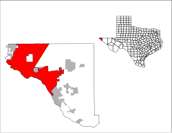 Location in El Paso County and the State of Texas | |
 El Paso Location in Texas | |
| Coordinates: 31°45′33″N 106°29′19″W / 31.75917°N 106.48861°W | |
| Country | United States |
| State | Texas |
| County | El Paso |
| First settlement | 1680 |
| Settled as Franklin | 1849 |
| Renamed El Paso | 1852 |
| Town laid out | 1859 |
| Incorporated | 1873 |
| Government | |
| • Type | Council–manager |
| • City Council |
|
| • City manager | Cary Westin (Interim) |
| Area | |
| • City | 259.25 sq mi (671.46 km2) |
| • Land | 258.43 sq mi (669.33 km2) |
| • Water | 0.82 sq mi (2.13 km2) |
| Elevation | 3,888 ft (1,185 m) |
| Population | |
| • City | 678,815 |
| • Rank | 66th in North America 22nd in the United States 6th in Texas |
| • Density | 2,626.69/sq mi (1,014.17/km2) |
| • Urban | 854,584 (US: 53rd) |
| • Urban density | 3,339.7/sq mi (1,289.5/km2) |
| • Metro | 868,859 (US: 67th) |
| Demonym | El Pasoan |
| GDP | |
| • El Paso (MSA) | $43.3 billion (2022) |
| Time zone | UTC−07:00 (MST) |
| • Summer (DST) | UTC−06:00 (MDT) |
| ZIP Codes |
|
| Area codes | 915 |
| FIPS code | 48-24000 |
| GNIS feature ID | 2410414[4] |
| Website | www |


Шаг ( / ɛ l ˈ p æ s oʊ / ; Испанский: [El ˈpaso] ; зажженная « Маршрут » или « пропуск » ) - это город в округа округе Эль -Пасо, штат Техас , США. Население 2020 года города из Бюро переписей США составило 678 815, [ 5 ] Сделать его 22-м самым густонаселенным городом в США , самый густонаселенный город в Западном Техасе и шестой по чистого населенного города в Техасе . [ 8 ] Его столичная статистическая зона охватывает все округа Эль -Пасо и Хадспет в Техасе, и в 2020 году население составило 868 859. [ 9 ]
Эль -Пасо стоит на границе с Рио -Гранде через границу штатов Мексики и Соединенные Штаты от Сьюдада Хуареса , самого густонаселенного города в мексиканском штате Чихуахуа . [ 10 ] В районе Лас -Крусес в соседнем США штате Нью -Мексико население составляет 219 561. [ 11 ] Со стороны США столичная область Эль -Пасо является частью более крупной комбинированной статистической зоны El Paso -Las , которая составляет 1 098 541. [ 11 ] Эти три города образуют объединенную международную столичную область, которую иногда называют Paso del Norte или Borderplex . Регион в 2,7 миллиона человек представляет собой крупнейшую двуязычную и бинационную рабочую силу в западном полушарии . [12]
The city is home to three publicly traded companies, and former Western Refining, now Marathon Petroleum,[13] as well as home to the Medical Center of the Americas,[14] the only medical research and care provider complex in West Texas and Southern New Mexico,[15] and the University of Texas at El Paso, the city's primary university. The city hosts the annual Sun Bowl college football postseason game, the second-oldest bowl game in the country.[16] El Paso has a strong federal and military presence. William Beaumont Army Medical Center, Biggs Army Airfield, and Fort Bliss are located in the area. Also headquartered in El Paso is the Drug Enforcement Administration domestic field division 7, El Paso Intelligence Center, Joint Task Force North, United States Border Patrol El Paso Sector, and U.S. Border Patrol Special Operations Group.
El Paso is a five-time All-America City Award winner, winning in 1969, 2010, 2018, 2020, and 2021,[17] and Congressional Quarterly ranked it in the top-three safest large cities in the United States between 1997 and 2014,[18] including holding the title of the safest city between 2011 and 2014.[19]
El Paso is also the second-largest majority-Hispanic city in the United States (after San Antonio), with 81% of its residents being Hispanic.[20]
History
[edit]Early years
[edit]The El Paso region has had human settlement for thousands of years, as evidenced by Folsom points from hunter-gatherers found at Hueco Tanks. This suggests 10,000 to 12,000 years of human habitation.[21] The earliest known cultures in the region were maize farmers. When the Spanish arrived, the Manso, Suma, and Jumano tribes populated the area. These were subsequently incorporated into the mestizo culture, along with immigrants from central Mexico, captives from Comanchería, and genízaros of various ethnic groups. The Mescalero Apache were also present.[22]
The Chamuscado and Rodríguez Expedition trekked through present-day El Paso and forded the Rio Grande where they visited the land that is present-day New Mexico in 1581–1582. The expedition was led by Francisco Sánchez, called "El Chamuscado", and Fray Agustín Rodríguez, the first Spaniards known to have walked along the Rio Grande and visited the Pueblo Indians since Francisco Vásquez de Coronado 40 years earlier. Spanish explorer Don Juan de Oñate was born in 1550 in Zacatecas, Zacatecas, Mexico, and was the first New Spain (Mexico) explorer known to have rested and stayed 10 days by the Rio Grande near El Paso, in 1598,[23] celebrating a Thanksgiving Mass there on April 30, 1598. Four survivors of the Narváez expedition, Álvar Núñez Cabeza de Vaca, Alonso del Castillo Maldonado, Andrés Dorantes de Carranza, and a Moor that was enslaved Estevanico, are thought to have crossed the Rio Grande into present-day Mexico about 75 miles south of El Paso in 1535.[24] El Paso del Norte (present-day Ciudad Juárez) was founded on the south bank of the Río Bravo del Norte (Rio Grande), in 1659 by Fray Garcia de San Francisco. In 1680, the small village of El Paso became the temporary base for Spanish governance of the territory of New Mexico as a result of the Pueblo Revolt, until 1692, when Santa Fe was reconquered and once again became the capital.[25]
The Texas Revolution (1836) was generally not felt in the region, as the American population was small, not more than 10% of the population. However, the region was claimed by Texas as part of the treaty signed with Mexico and numerous attempts were made by Texas to bolster these claims, but the villages that consisted of what is now El Paso and the surrounding area remained essentially a self-governed community with both representatives of the Mexican and Texan governments negotiating for control until Texas irrevocably took control in 1846.[26] During this interregnum, 1836–1848, Americans nonetheless continued to settle the region. As early as the mid-1840s, alongside long extant Hispanic settlements such as the Rancho de Juan María Ponce de León, Anglo-American settlers such as Simeon Hart and Hugh Stephenson had established thriving communities of American settlers owing allegiance to Texas.[26] Stephenson, who had married into the local Hispanic aristocracy, established the Rancho de San José de la Concordia, which became the nucleus of Anglo-American and Hispanic settlement within the limits of modern-day El Paso, in 1844: the Republic of Texas, which claimed the area, wanted a chunk of the Santa Fe trade. During the Mexican–American War, the Battle of El Bracito was fought nearby on Christmas Day, 1846. The Treaty of Guadalupe Hidalgo effectively made the settlements on the north bank of the river part of the US, separate from Old El Paso del Norte on the Mexican side.[26] The present New Mexico–Texas boundary placing El Paso on the Texas side was drawn in the Compromise of 1850.[27][28]
El Paso remained the largest settlement in New Mexico as part of the Republic of Mexico until its cession to the U.S. in 1848, when the Treaty of Guadalupe Hidalgo specified the border was to run north of El Paso De Norte around the Ciudad Juárez Cathedral which became part of the state of Chihuahua.[29]
El Paso County was established in March 1850, with San Elizario as the first county seat.[30] The United States Senate fixed a boundary between Texas and New Mexico at the 32nd parallel, thus largely ignoring history and topography. A military post called the "Post opposite El Paso" (meaning opposite El Paso del Norte, across the Rio Grande) was established in 1849 on Coons' Rancho beside the settlement of Franklin, which became the nucleus of the future El Paso, Texas; after the army left in 1851, the rancho went into default and was repossessed; in 1852, a post office was established on the rancho bearing the name El Paso as an example of cross-border town naming until El Paso del Norte was renamed Juarez in 1888. After changing hands twice more, the El Paso company was set up in 1859 and bought the property, hiring Anson Mills to survey and lay out the town, thus forming the current street plan of downtown El Paso.[31]
In Beyond the Mississippi (1867), Albert D. Richardson, traveling to California via coach, described El Paso as he found it in late 1859:
The Texan town of El Paso had four hundred inhabitants, chiefly Mexicans. Its businessmen were Americans, but Spanish was the prevailing language. All the features were Mexican: low, flat adobe buildings, shading cottonwoods under which dusky, smoking women and swarthy children sold fruit, vegetables, and bread; habitual gambling universal, from the boys' game of pitching quartillas (three-cent coins) to the great saloons where huge piles of silver dollars were staked at monte. In this little village, a hundred thousand dollars often changed hands in a single night through the potent agencies of Monte and poker. There were only two or three American ladies, and most of the whites kept Mexican mistresses. All goods were brought on wagons from the Gulf of Mexico and sold at an advance of three or four hundred percent on Eastern prices.[32]
From hills overlooking the town, the eye takes in a charming picture—a far-stretching valley, enriched with orchards, vineyards, and cornfields, through which the river traces a shining pathway. Across it appears the flat roofs and cathedral towers of the old Mexican El Paso; still further, dim misty mountains melt into the blue sky.[32]

During the Civil War, Confederate military forces were in the area until it was captured by the Union California Column in August 1862. It was then headquarters for the 5th Regiment California Volunteer Infantry from August 1863 until December 1864.[33]

After the Civil War's conclusion, the town's population began to grow as white Texans continued to move into the villages and soon became the majority. El Paso itself, incorporated in 1873, encompassed the small area of communities that had developed along the river. In the 1870s, a population of 23 non-Hispanic Whites and 150 Hispanics was reported.[34] With the arrival of the Southern Pacific, Texas and Pacific, and Atchison, Topeka and Santa Fe railroads in 1881, the population boomed to 10,000 by the 1890 census, with many Anglo-Americans, recent immigrants, old Hispanic settlers, and recent arrivals from Mexico. The location of El Paso and the arrival of these more wild newcomers caused the city to become a violent and wild boomtown known as the "Six-shooter Capital" because of its lawlessness.[31] Indeed, prostitution and gambling flourished until World War I when the Department of the Army pressured El Paso authorities to crack down on vice (thus "benefitting" vice in neighboring Ciudad Juárez). With the suppression of the vice trade and in consideration of the city's geographic position, the city continued into developing as a premier manufacturing, transportation, and retail center of the U.S. Southwest.[34]
1900–present
[edit]


In 1909, the El Paso Chamber of Commerce hosted U.S. President William Howard Taft and Mexican President Porfirio Díaz at a planned summit in El Paso, Texas, and Ciudad Juárez, Mexico, a historic first meeting between the Presidents of the two countries, and also the first time an American President crossed the border into Mexico.[35] However, tensions rose on both sides of the border, including threats of assassination; so the Texas Rangers, 4,000 U.S. and Mexican troops, U.S. Secret Service agents, FBI agents, and U.S. marshals were all called in to provide security.[36] Frederick Russell Burnham, a celebrated scout, was put in charge of a 250-strong private security detail hired by John Hays Hammond, who in addition to owning large investments in Mexico, was a close friend of Taft from Yale and a U.S. vice presidential candidate in 1908.[37][38] On October 16, the day of the summit, Burnham and Private C.R. Moore, a Texas Ranger, discovered a man holding a concealed palm pistol standing at the Chamber of Commerce building along the procession route in El Paso.[39][40] Burnham and Moore captured, disarmed, and arrested the assassin within only a few feet of Taft and Díaz.[41][42] By 1910, an overwhelming number of people in the city were Americans, creating a settled environment, but this period was short-lived as the Mexican Revolution greatly impacted the city, bringing an influx of refugees—and capital—to the bustling boom town. Spanish-language newspapers, theaters, movie houses, and schools were established, many supported by a thriving Mexican refugee middle class. Large numbers of clerics, intellectuals, and businessmen took refuge in the city, particularly between 1913 and 1915. Ultimately, the violence of the Mexican Revolution followed the large Mexican diaspora, who had fled to El Paso. In 1915 and again in 1916 and 1917, various Mexican revolutionary societies planned, staged, and launched violent attacks against both Texans and their political Mexican opponents in El Paso. This state of affairs eventually led to the vast Plan de San Diego, which resulted in the murder of 21 American citizens.[43] The subsequent reprisals by a local militia soon caused an escalation of violence, wherein an estimated 300 Mexicans and Mexican-Americans lost their lives. These actions affected almost every resident of the entire Rio Grande Valley, resulting in millions of dollars of losses; the result of the Plan of San Diego was long-standing enmity between the two ethnic groups.[43]
Simultaneously, other Texans and Americans gravitated to the city, and by 1920, along with the U.S. Army troops, the population exceeded 100,000, and non-Hispanic Whites once again were in the clear majority. Nonetheless, the city increased the segregation between Mexicans and Mexican-Americans with non-Hispanic Whites. One prominent form of segregation, in the form of immigration controls to prevent disease, allegedly was abused to create nonconsensual pornographic images of women distributed in local bars.[44] These rumors along with the perceived hazard from kerosene baths led to the 1917 Bath riots.[45] As a result of the increased segregation, the Catholic Church attempted to garner the Mexican-American community's allegiance through education and political and civic involvement organizations, including the National Catholic Welfare Fund.[46] In 1916, the Census Bureau reported El Paso's population as 53% Mexican and 44% Non-Hispanic whites.[47] Mining and other industries gradually developed in the area. The El Paso and Northeastern Railway was chartered in 1897, to help extract the natural resources of surrounding areas, especially in southeastern New Mexico Territory. The 1920s and 1930s had the emergence of major business development in the city, partially enabled by Prohibition-era bootlegging.[31] The military demobilization, and agricultural economic depression, which hit places like El Paso first before the larger Great Depression was felt in the big cities, though, hit the city hard. In turn, as in the rest of the United States, the Depression era overall hit the city hard, and El Paso's population declined through the end of World War II, with most of the population losses coming from the non-Hispanic White community. Nonetheless, they remained the majority to the 1940s.[citation needed]
During and following the war, military expansion in the area, as well as oil discoveries in the Permian Basin, helped to engender rapid economic expansion in the mid-1900s. Copper smelting, oil refining, and the proliferation of low-wage industries (particularly garment making) led to the city's growth. Additionally, the departure of the region's rural population, which was mostly non-Hispanic White, to cities like El Paso, brought a short-term burst of capital and labor, but this was balanced by additional departures of middle-class Americans to other parts of the country that offered new and better-paying jobs. In turn, local businesses looked south to the opportunities afforded by cheap Mexican labor. Furthermore, the period from 1942 to 1956 had the bracero program, which brought cheap Mexican labor into the rural area to replace the losses of the non-Hispanic White population. In turn, seeking better-paying jobs, these migrants also moved to El Paso. By 1965, Hispanics once again were a majority. Meanwhile, the postwar expansion slowed again in the 1960s, but the city continued to grow with the annexation of surrounding neighborhoods and in large part because of its significant economic relationship with Mexico.[citation needed]
The Farah Strike, 1972–1974, occurred in El Paso, Texas. This strike was originated and led by Chicanas, or Mexican-American women, against the Farah Manufacturing Company, due to complaints against the company inadequately compensating workers.[48] Texas Monthly described the Farah Strike as the "strike of the century".[49]
On August 3, 2019, a terrorist shooter espousing white supremacy killed 23 people at a Walmart and injured 22 others.[50][51][52][53]
Geography
[edit]
El Paso is located at the intersection of three states (Chihuahua, New Mexico, and Texas) and two countries (Mexico and the U.S.). It is the only major Texas city in the Mountain Time Zone. Ciudad Juarez was once in the Central Time Zone,[54] but both cities are now on Mountain Time. El Paso is closer to the capital cities of four other states: Phoenix, Arizona (430 miles (690 km) away);[55] Santa Fe, New Mexico (273 miles (439 km) away);[56] Ciudad Chihuahua, Chihuahua, (218 miles (351 km) away),[57] and Hermosillo, Sonora (325 miles (523 km) away)[58]—than it is to the capital of its own state, Austin (528 miles (850 km) away).[59] It is closer to Los Angeles, California (700 miles (1,100 km) away)[60] than it is to Orange, Texas (858 miles (1,381 km) away),[61] the easternmost town in the same state as this city.
El Paso is located within the Chihuahuan Desert, the easternmost section of the Basin and Range Region. The Franklin Mountains extend into El Paso from the north and nearly divide the city into two sections; the west side forms the beginnings of the Mesilla Valley, and the east side expands into the desert and lower valley. They connect in the central business district at the southern end of the mountain range.
The city's elevation is 3,740 ft (1,140 m) above sea level. North Franklin Mountain is the highest peak in the city at 7,192 ft (2,192 m) above sea level. The peak can be seen from 60 mi (100 km) in all directions. Additionally, this mountain range is home to the famous natural red-clay formation, the Thunderbird, from which the local Coronado High School gets its mascot's name. According to the United States Census Bureau, the city has a total area of 256.3 sq mi (663.7 km2).[62]
The 24,000-acre (9,700 ha) Franklin Mountains State Park, one of the largest urban parks in the United States, lies entirely in El Paso, extending from the north and dividing the city into several sections along with Fort Bliss and El Paso International Airport.
The Rio Grande Rift, which passes around the southern end of the Franklin Mountains, is where the Rio Grande flows. The river defines the border between El Paso and Ciudad Juárez to the south and west until the river turns north of the border with Mexico, separating El Paso from Doña Ana County, New Mexico. Mt. Cristo Rey, an example of a pluton, rises within the Rio Grande Rift just to the west of El Paso on the New Mexico side of the Rio Grande. Nearby volcanic features include Kilbourne Hole and Hunt's Hole, which are Maar volcanic craters 30 miles (50 km) west of the Franklin Mountains.
On November 8, 2023, a 5.3 magnitude Earthquake struck the El Paso region. The epicenter of the earthquake was 22 miles (35 kilometers) southwest of Mentone, according to the USGS[63][64]
Cityscape
[edit]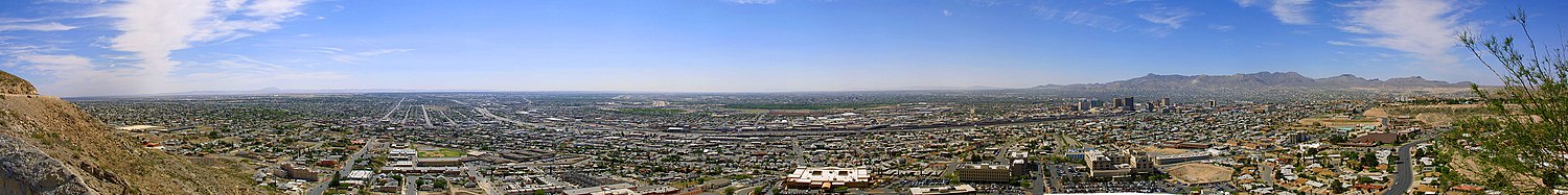
Tallest buildings
[edit]

| Rank | Building | Height | Floors | Built | |
|---|---|---|---|---|---|
| 1 | WestStar Tower | 314 ft (96 m)[65] | 20 | 2021 | |
| 2 | Wells Fargo Plaza | 302 ft (92 m)[65] | 21 | 1971 | |
| 3 | One San Jacinto Plaza | 280 ft (85 m)[66] | 20 | 1962 | |
| 4 | Stanton Tower | 260 ft (79 m)[66] | 18 | 1982 | |
| 5 | Plaza Hotel | 246 ft (75 m) | 19 | 1930 | |
| 6 | Hotel Paso del Norte Tower | 230 ft (70 m) | 17 | 1986 | |
| 7 | El Paso County Courthouse | 230 ft (70 m) | 14[67] | 1991 | |
| 8 | Blue Flame Building | 230 ft (70 m) | 18 | 1954 | |
| 9 | O. T. Bassett Tower – Aloft Hotel | 216 ft (66 m) | 15 | 1930 | |
| 10 | One Texas Tower | 205 ft (62 m) | 15 | 1921 | |
| 11 | Albert Armendariz Sr. U.S. Federal Courthouse | 205 ft (62 m) | 9[68] | 2010 |
El Paso's second-tallest building, the Wells Fargo Plaza, was built in the early 1970s as State National Plaza. The black-windowed, 302-foot (92 m)[65] building is famous for its 13 white horizontal lights (18 lights per row on the east and west sides of the building, and seven bulbs per row on the north and south sides) that were lit at night. The tower did use a design of the United States flag during the July 4 holidays, as well as the American hostage crisis of 1980, and was lit continuously following the September 11 attacks in 2001 until around 2006. During the Christmas holidays, a design of a Christmas tree was used, and at times, the letters "UTEP" were used to support University of Texas at El Paso athletics. The tower is now only lit during the holiday months, or when special events take place in the city.
Neighborhoods
[edit]Downtown and central El Paso
[edit]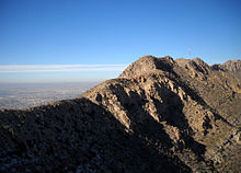
This part of town contains some of the city's oldest and most historic neighborhoods. Located in the heart of the city, it is home to about 44,993 people.[69] Development of the area started in 1827 with the first resident, Juan Maria Ponce de Leon, a wealthy merchant from Paso del Norte (present-day Ciudad Juárez), who built the region's first structure establishing Rancho Ponce within the vicinity of S. El Paso Street and Paisano Dr. when the city was barely beginning. Today, central El Paso has grown into the center of the city's economy and a thriving urban community. It contains numerous historic sites and landmarks, mostly in the Sunset Heights district. It is close to the El Paso International Airport, the international border, and Fort Bliss. It is part of the El Paso Independent School District.
Dr. James Day, an El Paso historian, said that downtown's main business area was originally centered between Second Avenue (now Paisano Drive) and San Francisco Avenue. At a later point, the main business area was centered around Stanton Street and Santa Fe Street. In the late 1800s, most of the White American residents lived to the north of the non-White areas, living in brick residences along Magoffin, Myrtle, and San Antonio Avenues. Hispanic-American residents lived in an area called Chihuahuita ("little Chihuahua"), which was located south of Second Avenue and west of Santa Fe Street. Several African Americans and around 300 Chinese Americans also lived in Chihuahuita. Many of the Chinese Americans participated in the building of railroads in the El Paso area.[70] Another downtown neighborhood is El Segundo Barrio, which is near the Mexico–U.S. border.[71]
Northwest El Paso
[edit]
Better known as West El Paso or the West Side, the area includes a portion of the Rio Grande floodplain upstream from downtown, which is known locally as the Upper Valley and is located on the west side of the Franklin Mountains. The Upper Valley is the greenest part of the county due to the Rio Grande. The West Side is home to some of the most affluent neighborhoods within the city, such as the Coronado Hills, Country Club, and Three Hills neighborhoods. It is one of the fastest-growing areas of El Paso. The main high schools in the westside include Canutillo High School, Coronado High School (El Paso, Texas), and Franklin High School (El Paso, Texas).
West-central El Paso
[edit]
West-central El Paso is located north of Interstate 10 and west of the Franklin Mountains. The University of Texas at El Paso (UTEP) and the Cincinnati Entertainment district are located in the heart of the area. Historic districts Kern Place and Sunset Heights are in this part of town.
Kern Place was founded in 1914 by Peter E. Kern, for whom the neighborhood was named.[72] The homes of Kern Place are unique in architecture and some were built by residents themselves.[72] One of the better known homes is the Paul Luckett Home located at 1201 Cincinnati Ave. above Madeline Park, and is made of local rock. It is known as "The Castle" due to its round walls and a crenelated rooftop.[72]
Kern Place is extremely popular with college and university students. The area is known for its glitzy entertainment district, restaurants and coffee shops that cater to both business patrons and university students.[73][74] After UTEP's basketball and football games, UTEP fans pack the Kern Place area for food and entertainment at Cincinnati Street, a small bar district. This bar scene has grown over the years and has attracted thousands to its annual Mardi Gras block party, as well as after sporting events or concerts. Young men and women make up the majority of the crowds who stop in between classes or after work.[citation needed]
Sunset Heights is one of the most historic areas in town, which has existed since the latter part of the 1890s. Many wealthy residents have had their houses and mansions built on this hill. Although some buildings have been renovated to their former glory, many have been neglected and have deteriorated. During the Mexican Revolution, a widely popular Mexican revolutionary leader, Doroteo Arango (also known as Francisco "Pancho" Villa), owned and resided in this area during the 1910s.[75] During the 1910 Mexican Revolution many Mexicans fled Mexico and settled in Sunset Heights.[76]
Northeast El Paso
[edit]
This part of town is located north of central El Paso and east of the Franklin Mountains. Development of the area was extensive during the 1950s and 1960s. It is one of the more ethnically diverse areas in the city due to the concentration of military families. The Northeast has not developed as rapidly as other areas, such as east El Paso and northwest El Paso, but its development is steadily increasing. The population is expected to grow more rapidly as a result of the troop increase at Ft. Bliss in the coming years. The area has also gained recognition throughout the city for the outstanding high-school athletic programs at Andress High School, Parkland High School, Irvin High School, and Chapin High School.
In May 2021 a major developer announced plans for a Master Planned Community in the Northeast modeled after Scarborough's Sunfield Master Planned Community in Buda, Texas. The first phase of the development is to include about 2,500 homes, 10-acre park, walking trails, a four-acre resort-like area with a lazy river, kiddy splash pad, pool, grass areas, and a food truck area, the developers reported. Jessica Herrera, director of the city of El Paso Economic and International Development Department, in a statement released by the developers, said Campo del Sol will generate hundreds of millions of dollars in tax revenues, "which will stimulate other growth and development on the north side of town".[77]
East El Paso
[edit]The area is located north of Interstate 10, east of Airway Blvd., and south of Montana Ave. It is the largest and fastest growing area of town with a population over 200,000.[78] It includes the 79936 ZIP Code, which was considered in 2013 as the most populous in the nation with over 114,000 people.[79]
Mission Valley
[edit]Formerly known as the lower valley, it includes part of Eastside and all lower valley districts. It is the third-largest area of the city, behind east El Paso and central El Paso. Hawkins Road and Interstate 10 border the Mission Valley. This location is considered the oldest area of El Paso, dating back to the late 16th century when present-day Texas was under the rule of New Spain.

In 1680, the Isleta Pueblo tribe revolted against the Spaniards who were pushed south to what is now El Paso. Some Spaniards and tribe members settled here permanently. Soon afterward, three Spanish missions were built; they remain standing, currently functioning as churches: Ysleta Mission-1682 (La Misión de Corpus Christi y de San Antonio de la Ysleta del Sur/Our Lady of Mt. Carmel), Socorro Mission-1759 (Nuestra Señora de la Purísima Concepción del Socorro)-1759, and San Elizario Chapel (Capilla de San Elcear)-1789.
On April 30, 1598, the northward-bound Spanish conquistadors crossed large sand dunes about 27 miles south of present-day downtown El Paso. The expeditionaries and their horses reportedly ran toward the river, and two horses drank themselves to death. Don Juan de Oñate, a New Spain-born conquistador of Spanish parents, was an expedition leader who ordered a big feast north of the Río Grande in what is now San Elizario. This was the first documented and true Thanksgiving in North America.[citation needed] Oñate declared la Toma (taking possession), claiming all territory north of the Río Grande for King Philip II of Spain.
Ysleta Del Sur Pueblo (related to the insurgent Isleta Pueblo Tribe) is also located in this valley. The Tigua is one of three Indian tribes in Texas whose sovereignty is recognized by the United States government. Ysleta is spelled with a "Y" because 19th-century script did not differentiate between a capital "Y" and a capital "I".
Some people in this area and its twin city across the river, Ciudad Juárez, are direct descendants of the Spaniards.
Texas and New Mexico suburbs
[edit]El Paso is surrounded by many cities and communities in both Texas and New Mexico. The most populated suburbs in Texas are Socorro, Horizon City, Fort Bliss, and San Elizario. Other Texas suburbs are Anthony, Canutillo, Sparks, Fabens, and Vinton.
Although Anthony, Santa Teresa, Sunland Park, and Chaparral lie adjacent to El Paso County, they are considered to be part of the Las Cruces, New Mexico metropolitan area by the United States Census Bureau.[80]
Climate
[edit]| El Paso, Texas | ||||||||||||||||||||||||||||||||||||||||||||||||||||||||||||
|---|---|---|---|---|---|---|---|---|---|---|---|---|---|---|---|---|---|---|---|---|---|---|---|---|---|---|---|---|---|---|---|---|---|---|---|---|---|---|---|---|---|---|---|---|---|---|---|---|---|---|---|---|---|---|---|---|---|---|---|---|
| Climate chart (explanation) | ||||||||||||||||||||||||||||||||||||||||||||||||||||||||||||
| ||||||||||||||||||||||||||||||||||||||||||||||||||||||||||||
| ||||||||||||||||||||||||||||||||||||||||||||||||||||||||||||

El Paso has a hot desert climate (Köppen BWh) featuring hot summers, with little humidity, and cool to mild, dry winters. Rainfall averages 8.8 in (220 mm) per year, much of which occurs from June through September, and is predominantly caused by the North American Monsoon. During this period, southerly and southeasterly winds carry moisture from the Pacific, the Gulf of California, and the Gulf of Mexico into the region. When this moisture moves into the El Paso area and places to the southwest, orographic lift from the mountains, combined with strong daytime heating, causes thunderstorms, some severe enough to produce flash flooding and hail, across the region.
The sun shines 302 days per year on average in El Paso, 83% of daylight hours, according to the National Weather Service; from this, the city is nicknamed "The Sun City".[82] Due to its arid, windy climate, El Paso often experiences sand and dust storms during the dry season, particularly during the springtime between March and early May. With an average wind speed often exceeding 30 mph (50 km/h) and gusts that have been measured at over 75 mph (120 km/h), these wind storms kick up large amounts of sand and dust from the desert, causing loss of visibility.

El Paso and the nearby mountains also receive snow. Weather systems have produced over 1 ft (30 cm) of snow on several occasions. In the 1982–1983 winter season, three major snowstorms produced record seasonal snowfall. On December 25–26, 1982, 6.0 in (15 cm) of snow fell, producing a white Christmas for the city.[83] This was followed by another 7.0 in (18 cm) on December 30–31, 1982. On April 4–7, 1983, 16.5 in (42 cm) of snow fell on El Paso, bringing the seasonal total to nearly 30 in (76 cm). On December 13–14, 1987, a record storm dumped over 22 in (56 cm) of snow on El Paso, and two weeks later (December 25–26), another 3 in (7.6 cm) fell, bringing the monthly total for December 1987 to an all-time record high of 25.9 in (66 cm)[84] of snow.[85] The average annual snowfall for the city varies widely between different neighborhoods at different elevations, but is 2.6 in (6.6 cm) at the airport (but with a median of 0, meaning most years see no snow at all).[86] Snow is most rare around Ysleta and the eastern valley area, which usually include large numbers of palm trees; in the higher neighborhoods, palm trees are more vulnerable to snow and cold snaps and are often seen with brown, frost-damaged fronds.

One example of El Paso's varying climate at its most extreme was the damaging winter storm of early February 2011, which caused closures of schools, businesses, and City Hall. The snow, which was light, stopped after about a day, but during the ensuing cold episode, municipal utilities went into a crisis. The high temperature on February 2, 2011, was 15 °F (−9 °C), the lowest daily maximum on record. In addition, the low temperature on February 3 was 1 °F (−17 °C), breaking the 5 °F (−15 °C) monthly record low set during the cold wave of 1899.[83] Loss of desert vegetation, such as Mexican/California palm trees, oleanders, and iceplants to the cold weather was one of the results. Two local power plants failed, forcing El Paso Electric to institute rolling blackouts over several days,[87] and electric wires were broken, causing localized blackouts. Many water utility pipes froze, causing areas of the city to be without water for several days.
Monthly means range from 46.1 °F (7.8 °C) in December to 84.4 °F (29.1 °C) in July, but high temperatures typically peak in June before the monsoon arrives, while daily low temperatures typically peak in July or early August with the higher humidity the monsoon brings (translating to warmer nights). On average, 42 night lows are at or below freezing, with 118 days of 90 °F (32 °C)+ highs and 28 days of 100 °F (38 °C)+ highs annually; extremely rarely do temperatures stay below the freezing mark all day.[85] The city's record high is 114 °F (46 °C) on June 30, 1994, and its record low is −8 °F (−22 °C) on January 11, 1962; the highest daily minimum was 85 °F (29 °C) on July 1 and 3, 1994, with weather records for the area maintained by the National Weather Service since 1879.
Flooding
[edit]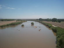

Although the average annual rainfall is only about 8.8 in (225 mm), many parts of El Paso are subject to occasional flooding during intense summer monsoonal thunderstorms. In late July and early August 2006, up to 10 in (250 mm) of rain fell in a week, the flood-control reservoirs overflowed and caused major flooding citywide.[88] The city staff estimated damage to public infrastructure at $21 million, and to private property (residential and commercial) at $77 million.[89] Much of the damage was associated with development in recent decades in arroyos protected by flood-control dams and reservoirs, and the absence of any storm drain utility in the city to handle the flow of rain water.
| Climate data for El Paso Int'l, Texas (1991–2020 normals, extremes 1879–present)[a] |
|---|
Graphs are unavailable due to technical issues. There is more info on Phabricator and on MediaWiki.org. |
See or edit raw graph data.
Demographics
[edit]| Census | Pop. | Note | %± |
|---|---|---|---|
| 1850 | 200 | — | |
| 1860 | 428 | 114.0% | |
| 1880 | 736 | — | |
| 1890 | 10,338 | 1,304.6% | |
| 1900 | 15,906 | 53.9% | |
| 1910 | 39,279 | 146.9% | |
| 1920 | 77,560 | 97.5% | |
| 1930 | 102,421 | 32.1% | |
| 1940 | 96,810 | −5.5% | |
| 1950 | 130,485 | 34.8% | |
| 1960 | 276,687 | 112.0% | |
| 1970 | 339,615 | 22.7% | |
| 1980 | 425,259 | 25.2% | |
| 1990 | 515,342 | 21.2% | |
| 2000 | 563,662 | 9.4% | |
| 2010 | 649,121 | 15.2% | |
| 2020 | 678,815 | 4.6% | |
| U.S. Decennial Census[92] Texas Almanac: 1850–2000[93] 2010–2010[5] El Paso 1850 to 2006[94] TX State Historical Association[95] | |||
| Historical racial profile | 2020[20] | 2010[96] | 2000[97] | 1990[98] | 1970[98] |
|---|
2020 census
[edit]| Race / Ethnicity (NH = Non-Hispanic) | Pop 2000[99] | Pop 2010[100] | Pop 2020[101] | % 2000 | % 2010 | % 2020 |
|---|---|---|---|---|---|---|
| White alone (NH) | 103,422 | 92,426 | 83,301 | 18.35% | 14.24% | 12.27% |
| Black or African American alone (NH) | 15,768 | 18,155 | 21,098 | 2.80% | 2.80% | 3.11% |
| Native American or Alaska Native alone (NH) | 1,616 | 1,633 | 1,653 | 0.29% | 0.25% | 0.24% |
| Asian alone (NH) | 5,874 | 7,092 | 9,123 | 1.04% | 1.09% | 1.34% |
| Pacific Islander alone (NH) | 378 | 737 | 1,195 | 0.07% | 0.11% | 0.18% |
| Some Other Race alone (NH) | 460 | 543 | 1,985 | 0.08% | 0.08% | 0.29% |
| Mixed race or Multiracial (NH) | 4,269 | 4,814 | 8,947 | 0.76% | 0.74% | 1.32% |
| Hispanic or Latino (any race) | 431,875 | 523,721 | 551,513 | 76.62% | 80.68% | 81.25% |
| Total | 563,662 | 649,121 | 678,815 | 100.00% | 100.00% | 100.00% |
At the 2020 census, its population was 12.2% non-Hispanic white, 3.1% Black or African American, 82.8% Hispanic or Latino of any race, and 1.3% Asian alone.
2010 census
[edit]At the 2010 U.S. census, 649,121 people, 216,694 households, and 131,104 families resided in the city. The 2019 U.S. Census Bureau estimates determined El Paso had a population of 681,728, an increase of 5.2% since the 2010 census.[102] By the 2020 United States census, there were 678,815 people, 230,905 households, and 162,460 families residing in the city.
The population density was 2,263.0 inhabitants per square mile (873.7/km2) in 2010. There were 227,605 housing units at an average density of 777.5 per square mile (300.2/km2). Of the 216,894 households in 2010, 37.6% had children under 18 living with them, 48.5% were married couples living together, 20.7% had a female householder with no husband present, and 25.3% were not families. About 21.5% of all households were made up of individuals, and 24.9% had someone living alone who was 65 years of age or older. The average household size was 2.95 and the average family size was 3.47. The 226,787 households in 2019 averaged of 2.97 people per household.
In the city, the age distribution was 29.1% under the age of 18, 7.5% from 20 to 24, 26.2% from 25 to 44, 22.8% from 45 to 64, and 11.1% who were 65 or older. The median age was 32.5 years according to census statistics from 2010.
As of 2010, the median income for a household in the city was $44,431, and for a family was $50,247. Males had a median income of $28,989 versus $21,540 for females. The per capita income for the city was $21,120. About 17.3% of families and 20.3% of the population were below the poverty line, including 28.5% of those under age 18 and 18.4% of those age 65 or over. The 2019 census estimates determined the city had an owner-occupied housing rate of 58.9% and median value of owner-occupied housing units at $127,400.[102] The median gross rent from 2015 to 2019 was $837. From 2015 to 2019, the city's median monthly homeowner cost with a mortgage was $1,255 and without a mortgage $429. El Paso had a median household income of $47,568 and per capita income of $22,734 in 2019. Roughly 19% of the population lived at or below the poverty line.

German communities
[edit]By 1996, a German community existed in El Paso, as the German Air Force headquarters for North America is in El Paso. A German school in El Paso serves all grade levels, though as of 1996, most of its students begin attending American schools at the secondary level.[103] The German school is on Fort Bliss.[104]
Religion
[edit]Christianity is the largest religion in the city and its metropolitan statistical area. Nearly 45% of its population claimed affiliation with the Catholic Church in 2020; they are served by the Roman Catholic Diocese of El Paso.[105][106] Protestants form a minority of Christians in the city limits, and the remainder of the non-Christian population were followers of Judaism, Islam, or eastern faiths, including Buddhism or Hinduism. The irreligious made the second largest non-Christian group.
Economy
[edit]| # | Employer | Number of Employees |
|---|---|---|
| 1 | Fort Bliss | 47,628 |
| 2 | El Paso Independent School District | 7,875 |
| 3 | Socorro Independent School District | 7,195 |
| 4 | City of El Paso | 6,840 |
| 5 | T&T Staff Management | 6,187 |
| 6 | Ysleta Independent School District | 6,022 |
| 7 | The Hospitals of Providence | 5,300 |
| 8 | University of Texas at El Paso | 3,170 |
| 9 | El Paso Community College | 3,102 |
| 10 | El Paso County | 2,980 |
| 11 | University Medical Center | 2,800 |
| 12 | DATAMARK Inc. | 2,800 |
| 13 | Alorica | 2,500 |
| 14 | GC Services Lp | 2,250 |
| 15 | Las Palmas Del Sol Healthcare | 2,184 |
El Paso has a diversified economy focused primarily within international trade, military, government civil service, oil and gas, health care, tourism, and service sectors. The El Paso metro area had a GDP of $29.03 billion in 2017.[108] There was also $92 billion worth of trade in 2012.[109] Over the past 15 years the city has become a significant location for American-based call centers. Cotton, fruit, vegetables, and livestock are also produced in the area. El Paso has added a significant manufacturing sector with items and goods produced that include petroleum, metals, medical devices, plastics, machinery, defense-related goods, and automotive parts. On July 22, 2020, Amazon announced plans to open the first 625,000 square foot fulfillment center in El Paso.[110] Owing to its location on a border, the city is the second-busiest international crossing point in the U.S. behind San Diego.[111]
El Paso is home to one Fortune 500 company, Western Refining, which is listed on the New York Stock Exchange (NYSE).[112] This makes the city one of six Texas metro areas to have at least one Fortune 500 company call it home; the others being Houston, Dallas-Fort Worth, San Antonio, Austin, and Corpus Christi.[113] The second publicly traded company is Helen of Troy Limited, a NASDAQ-listed company that manufactures personal health-care products under many labels, such as OXO, Dr. Scholl's, Vidal Sassoon, Pert Plus, Brut, and Sunbeam, and the third is El Paso Electric listed on the NYSE, a public utility engaging in the generation, transmission, and distribution of electricity in West Texas and southern New Mexico. The fourth publicly traded company is Western Refining Logistics, also traded in the NYSE. It is a Western Refining subsidiary, which owns, operates, develops, and acquires terminals, storage tanks, pipelines, and other logistics assets.
More than 70 Fortune 500 companies have offices in El Paso, including AT&T, ADP, Boeing, Charles Schwab, Delphi, Dish Network, Eureka, Hoover, Raytheon, USAA and Verizon Wireless.[114][115] Hispanic Business Magazine included 28 El Paso companies in its list of the 500 largest Hispanic owned businesses in the United States.[116] El Paso's 28 companies are second only to Miami's 57. The list of the largest Hispanic owned businesses includes companies like Fred Loya Insurance, a Hispanic 500 company and the 18th largest Hispanic business in the nation. Other companies on the list are Dos Lunas Spirits, Dynatec Labs, Spira Footwear, DATAMARK, Inc. and El Taco Tote. El Paso was home to El Paso Corporation formerly known as El Paso Natural Gas Company.
The city also has a large military presence with Fort Bliss, William Beaumont Army Medical Center, and Biggs Army Airfield. The defense industry in El Paso employs over 41,000 and provides a $6 billion annual impact to the city's economy.[117] In 2013, Fort Bliss was chosen as the newly configured U.S. Air Force Security Forces Regional Training Center which added 8,000 to 10,000 Air Force personnel annually.[118]
In addition to the military, the federal government has a strong presence in El Paso to manage its status and unique issues as an important border region. Operations headquartered in El Paso include the DEA Domestic Field Division 7, El Paso Intelligence Center, Joint Task Force North, U.S. Border Patrol El Paso Sector, and U.S. Border Patrol Special Operations Group.
Call-center operations employ more than 10,000 people in the area.[citation needed] Automatic Data Processing has an office in West El Paso, employing about 1,100 people with expansion plans to reach 2,200 by 2020.[119]
Tourism is another major industry in El Paso, bringing in $1.5 billion and over 2.3 million visitors annually due to the city's sunny weather, natural beauty, rich cultural history, and many outdoor attractions.[120]
Education is also a driving force in El Paso's economy. El Paso's three large school districts are among the largest employers in the area, employing more than 20,000 people among them. UTEP has an annual budget of nearly $418 million and employs nearly 4,800 people.[121][122] A 2010 study by the university's Institute for Policy and Economic Development stated the university's impact on local businesses is $417 million annually.[123]
Arts and culture
[edit]The culture of El Paso, Texas is influenced heavily by the mixing of American and Mexican cultures, due to the city's position on the U.S. Mexico border, its large Chicano population, and its history as part of Hispanic America and Mexico.
Annual cultural events and festivals
[edit]The Amigo Airsho is one of El Paso's premier events, and is ranked as one of the top-10 air shows in the country, filled with air entertainment and ground activities. Acts include the Franklin's Flying Circus, where performers walk on the wings of an airborne plane. Ground activities include a jet-powered school bus. After 31 years of being held at Biggs Army Airfield, the show was moved to Dona Ana Airport in 2014.[124]
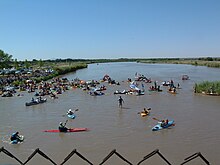
The KLAQ Great River Raft Race is an annual event celebrated on the second to last Saturday of June. Participants are encouraged to ride the river and float the Rio Grande with family and friends. The organizers encourage the building of unique rafts that get down the river, with prizes and trophies awarded for the most points earned, best-looking crew, and best-decorated raft. The race starts at the Vinton Bridge and ends 3 miles downstream at the Canutillo Bridge.[125]
The Southwestern International PRCA Rodeo is the 17th-oldest rodeo in the nation and El Paso's longest-running sporting event. Consistently ranked as one of the top 50 shows in the country by the Professional Rodeo Cowboys Association, this charitable event is a true celebration of western culture and heritage.[126]

La Fiesta de las Flores is one of the oldest Hispanic festivals in the Southwest. The three-day fiesta is held each year during the Labor Day weekend and emphasizes El Paso's Hispanic heritage and culture. The festival attracts 20,000 to 30,000 visitors from El Paso County, New Mexico, West Texas, and the State of Chihuahua, Mexico.[127] Activities included in the fiesta are crowning of the queen, a Fiesta Parade, Senior Appreciation Dance, Military Appreciation Day, and live entertainment. The fiesta is also well known for the authentic regional cuisine, arts and crafts, games, and services available for the enjoyment of all attendees. Over 80 booths, sponsored by local vendors and nonprofit organizations, create the Hispanic ambience and culture.
The El Paso Balloonfest is an annual event celebrated on Memorial Day weekend and is self described as "3 days of hot air balloons filling the El Paso skies, 3 afternoons of concerts and fun in the sun at Wet N' Wild Waterworld in Anthony, Texas". Over 60 balloons take to the air from TFCU launch field, which is adjacent to the water park. After the balloons launch, visitors have a weekend of water rides, swimming, concerts, and grilling. The concert aspect of the event features local bands, starting at noon, and different headlining artists in the afternoon.[128] Overnight camping has been added for 2014.[129]
The El Paso Sun City Pride is the largest annual LGBT event in the region, attracting thousands every June. The event was established in 2007.[130][131]
Music festivals
[edit]The annual El Paso Downtown Street Festival is held during the last weekend of June in downtown El Paso near the El Paso Convention Center.[132] It is the oldest musical festival in the city and brings local, regional, and nationally known acts.
The annual Neon Desert Music Festival is a two-day event usually held on the last Saturday and Sunday of May on five stages in downtown El Paso, stretching from San Jacinto Plaza to Cleveland Square.[133] The festival brings over 30 acts from the worlds of indie rock, Latin, and electronic dance music.
The outdoor concert series, started in 1983, is held annually at the Chamizal National Memorial and draws over 60,000 attendees. It features local and international performers with wide-ranging musical genres: Classical, Country, Tejano, rock and others. The evening concerts are showcased every Sunday afternoon and start in early June and end in the middle of August.[134]
The only El Paso musical festival not held downtown, instead it is held at Ascarate Park. The Sun City Music Festival is a two-day event dubbed as the largest electronic dance music festival in Texas.[135]
The Texas Showdown Festival is an annual event celebrating musicians and tattoo artists under one roof.[136] Dubbed as the world's largest tattoo and musical festival, the event is held usually the last weekend of July at the El Paso County Coliseum.
Performing arts
[edit]
The outdoor musical extravaganza Viva! El Paso is performed in the McKelligon Canyon Amphitheatre. It is locally produced and chronicles the 400-year history and cultural evolution of the El Paso region. The show is performed each Friday and Saturday night in June, July, and August. It has entertained local residents and out-of-town visitors for over 35 years.[137]
The El Paso Symphony was established in the 1930s, and is the oldest performing-arts organization in El Paso and the longest continuously running symphony orchestra in Texas.[138] It has received both national and international recognition as a result of its very successful tours of Germany in 1996 and Turkey in 2000, and continues to represent the El Paso region with pride and distinction. The El Paso Symphony Orchestra Association season is anchored by 12 classical concerts. Special events serve as outreach toward new audiences.
Ballet was largely nonexistent in El Paso until the arrival of Ingeborg Heuser, a professional ballerina from Germany, in the 1950s. Heuser taught ballet at UTEP for 47 years and founded the city's first professional ballet company, firstly known as Texas Western Civic Ballet and eventually as Ballet El Paso. The company dissipated due to financial trouble in 1997 and Heuser retired from UTEP soon after.[139][140] The El Paso Youth Ballet was founded in 2009 by Heuser's student, Marta Katz, following Heuser's departure from the university. With students from the youth ballet, Heuser staged her last Nutcracker in 2006. The youth company continues to perform the Nutcracker and other preprofessional pieces in and around the El Paso area. The company provides the only platform for young ballet dancers to train and perform at such a level within the city since the folding of Ballet El Paso.[141]
El Paso City Ballet is a current professional ballet company in El Paso, providing local employment for professional dancers in the field of ballet. The company performs a variety of classical and contemporary works choreographed by Artistic Director Lisa Skaf and artists from the US and Latin America.[142] It has been active since 2005, performing yearly productions.
Theaters
[edit]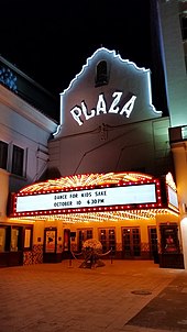
The Plaza Theatre is a National Historic Building of Significance built in 1930.[143] It features the 2,050-seat Kendall Kidd Performance Hall, and the smaller 200-seat Philanthropy Theatre. It hosts Broadway productions, musical concerts, individual performers, and the annual Plaza Classic Film Festival.[143]
The Abraham Chavez Theatre is a 2,500-seat concert hall adjacent to the Williams Convention Center. Its exterior resembles a sombrero and features a three-story glass main entrance. The theatre is named after Maestro Abraham Chavez, who was the longtime conductor of the El Paso Symphony. Inside, the theatre has a 5,000-square-foot (460 m2) lobby and a 40-by-56-ft stage, as well as 14 dressing rooms. The theater's seating is in three levels. Also, a meeting room is adjacent to the theater.[143]
Events held at Chavez Theatre include concerts, Broadway shows, graduation ceremonies, performances of the El Paso Symphony Orchestra, and other special events.
McKelligon Canyon is a 90-acre (360,000 m2) park, located in the Franklin Mountains, open to hikers and picnickers. In the canyon, McKelligon Canyon Amphitheatre is surrounded on three sides by canyon walls; the 1,500-seat amphitheater is used for concerts and special events, such as Viva! El Paso.[144]
The El Paso Playhouse, a community theatre, provides entertainment and educational experiences to a diverse multicultural population through the high-quality production of plays and theatrical events. The playhouse provides a venue for artists, technicians, patrons, and community members to participate in the arts through regularly scheduled season productions and holiday performances. The theater is affiliated with Kids-N-Co, a theater for child actors to children's performances .[145]
The UTEP Dinner Theatre located inside the UTEP campus, and was founded in 1983 and is entirely produced, designed and directed by students. The theatre presents 4 fully staged musicals each season and a fully staged student produced musical.[146]
Area museums
[edit]
The Centennial Museum and Chihuahuan Desert Gardens, located on the grounds of UTEP, includes a comprehensive collection of El Paso Brown, Native American pottery, as well as educational exhibits for students.
The El Paso Museum of Archaeology is located on the eastern slope of North Franklin Mountain, west of Gateway South Blvd. on TransMountain Rd.[147] Its grounds include native plants of the American Southwest, as well samples of Native American shelters, in an unspoiled location. The museum includes dioramas for school children that illustrate the culture and geology of the American Southwest, such as Hueco Tanks in El Paso County. One diorama (see image to the right) is of the Cueva de la Olla[148] (cave of the pot) which is located in the Sierra Madre of Chihuahua, an example of the Paquimé culture.[149]
The El Paso Museum of Art is located next to the Plaza Theater adjacent to San Jacinto Plaza, the public square downtown. It contains works of Southwestern artists such as Tom Lea.
Other area museums include:
- El Paso Holocaust Museum and Study Center
- International Museum of Art El Paso
- El Paso Museum of History[150]
- Fort Bliss Museums and Study Center[151]
- Insights El Paso Science Museum[152]
- The Magoffin Homestead, dating from 1875, is now a state historic site.
- The National Border Patrol Museum is located adjacent to the El Paso Museum of Archaeology.
- Railroad and Transportation Museum of El Paso[153]
- The Gene Roddenberry Planetarium[154]
- Lynx Exhibits[155]
Sites within the city limits
[edit]
- Ysleta Mission is recognized as the oldest continuously operated parish in the State of Texas.
- Cathedral of Saint Patrick erected in 1916 is the seat of the Roman Catholic Diocese of El Paso.
- Chamizal National Memorial
- El Paso Zoo – a 35-acre (14 ha) facility housing 220 species.[156]
- Magoffin Home State Historic Site
- Plaza Hotel
- Union Depot
- El Paso High School
- University of Texas at El Paso The university's distinctive style is a type of fortress architecture, Dzong, found in the present and former Buddhist mountain kingdoms of the Himalayas, Bhutan and Tibet.[157][158]
Sports
[edit]

El Paso is home to the Sun Bowl,[159] the second-oldest consecutive college football contest (after the Rose Bowl). Its first game was held in 1935.[159]
On September 18, 2012, the city council voted to approve the demolition of its city hall to make way for Southwest University Park,[160] the new home of the El Paso Chihuahuas Triple-A team (San Diego Padres affiliate); it opened in 2014. The team was purchased by Mountainstar Sports Group of El Paso.[161] City Hall was demolished on April 14, 2013.
The El Paso Marathon takes place annually since 2007. The El Paso Locomotive FC soccer team began playing in 2019 in the USL Championship. They play their home matches at the Southwest University Park.[162]
| Club | Sport | League | Venue | Capacity |
|---|---|---|---|---|
| El Paso Chihuahuas | Baseball | PCL | Southwest University Park | 9,500 |
| El Paso Locomotive FC | Soccer | USLC | Southwest University Park | 9,500 |
| El Paso Rhinos | Ice hockey | NAHL | Sierra Providence Event Center | 5,250 |
| UTEP Miners Football | NCAA Division I FBS Football | C-USA | Sun Bowl Stadium | 51,500 |
| UTEP Basketball Men | NCAA Division I Basketball | C-USA | Don Haskins Center | 12,000 |
| UTEP Basketball Women | NCAA Division I Basketball | C-USA | Don Haskins Center | 12,000 |
| UTEP Softball | NCAA Division I Softball | C-USA | Helen of Troy Field | 607 |
| UTEP Track and Field | NCAA Division I Track and Field | C-USA | Kidd Field | 15,000 |
| UTEP Women's Soccer | NCAA Division I Soccer | C-USA | University Field | 500 |
| EPCC Baseball | NJCAA Division I Baseball | WJCAC | EPCC Baseball Field | 520 |
Parks and recreation
[edit]El Paso is home to the largest urban park in the nation.[163] The Franklin Mountains State Park, with its more than 24,248 acres (9,813 ha), is completely located within the city limits. It is considered a small range (23 miles long, 3 miles (4.8 km) wide) that extends from the city north into New Mexico.[164] It is home to the highest peak in the county North Franklin Mountain at 7,192 feet.The park is open year-round for recreation including hiking, mountain biking, picnicking, scenic driving and views of the city. Scenic Drive runs along the mountain range,[165] and is designated as a city park[166] to allow better vandalism control and cleanup,[167][168] Roads are closed to vehicles on certain Sundays to allow walking, running, cycling, and skating.[169][170] The road offers views of El Paso, as well as nearby Ciudad Juárez, across the Mexico–United States border.[171][172]

The Wyler Aerial Tramway is operated by the Texas Parks and Wildlife Department and is in the Franklin Mountains State Park. The tramway complex covers 196 acres (0.79 km2) on the east side of the Franklin Mountains. The gondolas travel along two 2,600-foot (790 m) 1+3⁄8-diameter steel cables to Ranger Peak, 5,632 feet (1,717 m) above sea level. The trip takes about four minutes and lifts riders 940 feet (290 m) above the boarding area.The tramway was built in 1959 by KTSM radio to aid in the construction of a transmitter tower. Karl O. Wyler managed the project. First opening to the public as the El Paso Aerial Tramway, the facility provided rides from 1960 to 1986, when high liability insurance costs forced the tram to stop public operations. The tram was only used to service the transmitter towers. Wyler donated the tramway for public use in his will. The Texas Parks and Wildlife Department accepted the donation in 1997 and renovated and re-opened the tramway to the public in 2001. The tramway was closed indefinitely on September 18, 2020.[173]

Hueco Tanks State Historic Site is a Texas historic site in the Hueco Tanks area, approximately 32 miles (51 km) northeast of downtown El Paso and just west of the Hueco Mountains. The park is popular for recreation such as birdwatching and bouldering, and is culturally and spiritually significant to many Native Americans. This significance is partially manifested in the pictographs (rock paintings) that can be found throughout the region, many of which are thousands of years old.[174] Hueco Tanks is also widely regarded as one of the best areas in the world for bouldering (rock climbing, low enough to attempt without ropes for protection), unique for its rock type, the concentration and quality of the climbing, and after which the Hueco bouldering grades are named. In any given climbing season, which generally lasts from October through March, it is common for climbers from across Europe, Asia, and Australia to visit the park. Since implementation of the Public Use Plan, following a brief closure of the entire park due to the park service's inability to manage the growing crowds of international climbers, volunteer or commercial guides are required to access more than 2/3 of the park's area. Only North Mountain is accessible without guides, and then only for about 70 people at any given time. The park offers camping and showers for a small fee a day or, as is most popular for climbers, the nearby Hueco Rock Ranch offers camping where climbers can relax and socialize.
Located in downtown El Paso, San Jacinto Plaza is a historical park notable for its alligator statues in the middle of the area. Known as "Alligator Plaza", it used to have a pond that held live alligators that the community can interact with starting in 1962. They were removed and relocated to the El Paso Zoo in 1974. The area around the park is typically used to hold major events such as "Chalk the Block Arts Festival"[175] and "Winterfest".
The Chamizal National Memorial is a 54.90-acre (22.22 ha) memorial park that serves primarily as a cultural center and contains art galleries, a theater, and an amphitheatre. A museum detailing the history of the Mexico–U.S. border is located inside the visitor center.
The city is also home to 242 municipal parks.[176][177]
Botanical gardens
[edit]
- The Chihuahuan Desert Gardens (CDG) display the flora of the Chihuahuan Desert and adjacent regions in the United States and Mexico. The Gardens were formally dedicated in September 1999 and contain over 625 different species of plants, comprising one of the largest captive assemblages of Chihuahuan Desert flora in the world.[178]
- The El Paso Municipal Rose Garden (officially named the All-American Rose Selection (AARS) public garden) is one of over 100 certified gardens within the United States. There are over 1,900 rosebushes with 500 varieties. The wrought-iron fenced garden has wide walkways with handicap accessibility, raised beds, a waterfall, and trees and shrubs. Several new rose varieties are planted each year, and after two years the highest-rated are named and receive the AARS symbol.[179]
- Feather Lake is a 43.5-acre (17.6 ha) wildlife sanctuary based on a 40-acre (16 ha) wetland built by the City of El Paso in 1969 as a stormwater-retention basin. Since 1976, the El Paso/Trans-Pecos Audubon Society has leased this land from the city and managed it for wildlife. Over 200 different species of birds, especially those associated with water, have been observed at the sanctuary. Fauna residing there include muskrats, spiny softshell turtles, pond sliders, and Trans-Pecos striped whiptail lizards.[180]
- Keystone Heritage Park comprises an Archaic-period archaeological site, wetlands, and a desert botanical garden. The 4,500-year-old site is one of the oldest villages in the United States. The wetlands are home to many birds, and over 200 species have been spotted there on their seasonal migrations. The botanical garden features a variety of native plants, and includes a pavilion and a replica of an Archaic period brush hut. The newest component, The Chihuahuan Desert Experience, is a work in progress that will allow visitors to stroll the 900-mile (1,400 km) length of desert over a 17-acre (6.9 ha) recreation of the plant indigenous life.[181]
- Rio Bosque Wetlands is a 372-acre (151 ha) city park, managed by the Center for Environmental Resource Management of the University of Texas at El Paso, which began restoration efforts in 1998. In the fall and winter, water flows through the park along the route of the river before it was confined within levees in the 1930s. Many animals and birds have returned to the area as the restoration proceeds, and over 200 species of birds have been sighted.[182]
Golf courses
[edit]The metro area has 16 golf courses including Butterfield Trail Golf Club, the only public premium daily fee Tom Fazio designed golf course in the state of Texas.[183] It was ranked No. 1 in Texas and No. 3 in the Nation on Golfweek's 2013 Best Municipal Golf Courses.[184] Other golf courses found in the county include:
Government
[edit]| El Paso City Council[192] | |
|---|---|
 | |
| Oscar Leeser | Mayor
Elected At-Large |
| Brian Kennedy | District 1,
Northwest, Upper Valley |
| Josh Acevedo | District 2,
West Central |
| Cassandra Hernandez | District 3,
East Central |
| Joe Molinar | District 4,
Northeast |
| Isabel Salcido | District 5,
Upper Eastside |
| Art Fierro | District 6,
Eastside |
| Henry Rivera | District 7,
Lower Valley |
| Chris Canales | District 8, Downtown, Southside & Westside |
City
[edit]The city government is officially nonpartisan. Mayors and city council members are elected for four year terms and may not serve more than two full terms or for more than 10 years total in their respective offices.[193] Municipal elections were held in May in odd-numbered years until a voter-approved charter amendment changed this to November in even-numbered years, beginning in 2018.[194]
The city operates under a council–manager form of government. Power is concentrated in the eight-member elected city council and mayor, who hire a manager to carry out its directives and oversee the delivery of public services. The current city manager is Cary Westin, who holds the position on an interim basis, and the current mayor of El Paso is Oscar Leeser, who was elected to the office in 2020 (Leeser served an earlier non-consecutive term from 2013 to 2017).[195] The terms of Leeser, Acevedo, Hernandez, Molinar, and Rivera will end in January 2025. The terms of Canales, Fierro, Kennedy, and Salcido will end in January 2027, but Kennedy and Salcido are leaving office in January 2025 due to their mayoral runs.
Hernandez and Rivera have been on the council since 2017; Salcido since 2019; Molinar since 2021; Canales, Fierro, and Kennedy since 2023; Acevedo since 2024. Due to the term limits clause of the city charter, Leeser, Hernandez, Rivera, and Salcido are ineligible for reelection. All other councilors are eligible for reelection.
County
[edit]The El Paso County Judge is Ricardo Samaniego, and the County Commissioners are Carlos Leon (Precinct 1), David Stout (Precinct 2), Iliana Holguin (Precinct 3), and Sergio Coronado (Precinct 4). The commissioners and the county judge are Democrats.
Leon was first elected to his position in 2012, and was re-elected in 2016. Stout was first elected to his position in 2014, and was re-elected in 2018 and 2022. Samaniego was first elected in 2018, and was re-elected unopposed in 2022. Holguin was first elected to her position in 2020. Coronado was first elected to his position in 2022.
State
[edit]The El Paso metropolitan area is represented in the Texas State House by Democrats Eddie Morales, Mary Gonzalez, Joe Moody, Claudia Ordaz, and Lina Ortega, and in the State Senate by Cesar Blanco (D-El Paso).[196]
The Texas Department of Criminal Justice operates the El Paso I District Parole Office in the city. The El Paso II District Parole Office is in an unincorporated area east of Horizon City.[197]
Federal
[edit]El Paso City and County vote overwhelmingly Democratic, like most of the Texas–Mexico border area and urban Texas.[198]
In the United States House of Representatives, most of El Paso is part of Texas's 16th congressional district represented by Democrat Veronica Escobar. A small sliver in the eastern part of the city is part of Texas's 23rd congressional district, represented by Republican Tony Gonzales.[199] The current U.S. senators for Texas are Ted Cruz (R-Texas) and John Cornyn (R-Texas).
Education
[edit]

El Paso is home to the University of Texas at El Paso, the largest public university in the region. UTEP was ranked as the 7th best university in Washington Monthly's 2013 National University Rankings, just behind Stanford and ahead of Harvard.[200] Also, the university's School of Engineering is the nation's top producer of Hispanic engineers with M.S. and Ph.D. degrees.[201]
El Paso is also home to Texas Tech University Health Sciences Center at El Paso, Paul L. Foster School of Medicine, Texas Tech College of Architecture at El Paso,[202] Brightwood College, Park University, Southwest University, Webster University and the University of Phoenix. Also due to its proximity, many El Paso students attend New Mexico State University where the school offers in-state tuition to El Paso County residents.[203]
The El Paso Community College's boundary includes all of El Paso County.[204] There are several technical schools and for profit schools. El Pasoans also have access to the Doña Ana Community College with campuses in Sunland Park, Anthony and Chaparral, New Mexico: This community college is a part of the New Mexico State University system.
El Paso area students attend public schools in four school districts that cover portions of the city limits: El Paso Independent School District, Ysleta Independent School District, Socorro Independent School District and Canutillo Independent School District; there are nine independent school districts in the county.[205] Numerous accredited private preparatory schools also serve El Paso students. These include various pre-high school religious (Christian, Jewish) affiliates and Montessori schools, Cathedral High School, Loretto Academy, Father Yermo High School, Lydia Patterson Institute, Faith Christian Academy, El Paso Jewish Academy, Rose of Sharon Christian Academy, Zion Lutheran Day School and Radford School. The University of El Paso offers the country's only bilingual M.F.A. creative writing program.[206]
El Paso is home to bi-national economic development groups; the Hub of Human Innovation and Technology Hub. The industry groups' tertiary vocational programs, give workforce training in automation, robotics and AI technology.[207][208]
Public libraries
[edit]The El Paso Public Library serves the needs of the public in El Paso. It consists of 12 branches, a bookmobile, a mobile computer classroom and a mobile outreach unit (Kidsmobile). It also has multiple outreach services available.[209]
Media
[edit]Newspapers
[edit]The main newspapers are the English-language daily El Paso Times, founded in 1881; the Spanish-language daily El Diario de El Paso, and the online newspaper El Paso Herald-Post[210] started in 2015. The original and defunct El Paso Herald Post was also founded in 1881 as the El Paso Herald, which then merged with the El Paso Post in 1931. The paper was shut down in 1997. El Paso Matters is an online newspaper.[211]
Weekly and niche magazines:
- El Paso Inc[212]
- El Paso Scene[213]
- La Polaka[214]
- Jrznoticias[215]
- The City Magazine[216]
- The Prospector, published by the University of Texas at El Paso[217]
- Tejano Tribune, published by El Paso Community College[218]
Radio stations
[edit]Radio stations from Las Cruces, New Mexico, and Ciudad Juárez, Chihuahua, can also be heard within the El Paso market.
Television
[edit]El Paso was the largest city in the United States without a PBS television station within the city limits until 1978. El Paso viewers had to watch channel 22, KRWG, from Las Cruces until 1978. In fact, the city had only three English-speaking channels and two Spanish-language channels (channel 2 and channel 5) from Juarez, and cable TV subscribers in the 1970s and 1980s could receive four Los Angeles independent channels: KTLA, KHJ, KTTV and KCOP as well as Spanish-language stations KMEX of Los Angeles and KWEX of San Antonio usually sharing the same cable channel slot. Over time, as more television stations signed on, more cable channels were added and those stations added network affiliations, the Los Angeles and San Antonio stations disappeared from the lineup. The last to be removed was KTLA in the fall of 2006 as a consequence of the WB-UPN merger into The CW, when KVIA-TV launched a digital subchannel with the network's programming.[citation needed]
Инфраструктура
[ редактировать ]Здравоохранение
[ редактировать ]
Эль-Пасо является медицинским центром Западного Техаса и южного Нью-Мексико , где проходит многочисленные современные медицинские центры. Некоторые из лучших больниц города включают университетский медицинский центр , медицинский центр Вильгельма Бомонта , медицинский центр Сьерра, Медицинский центр Лас -Пальмас, медицинский центр Del Sol, Медицинский центр Sierra Providence East, Детская больница Эль -Пасо , [ 219 ] и Мемориальная больница Провиденса. Университетский медицинский центр является единственным травматологическим центром уровня I в регионе. Медицинский центр армии Уильяма Бомонта будет заменен новым государством искусства замену блаженства за 1,2 миллиарда долларов [ 220 ] Ожидается, что откроется в 2020 году. [ 221 ] Новейшая больница Эль-Пасо, больницы ПРОВИДЕНСКАЯ ПЕРСОНТАНА, открылась в Северо-Западном Эль-Пасо 27 января 2017 года. Учебная больница на 106 коек является сотрудничеством между Центром медицинских наук Техасского университета Эль-Пасо и больницами Провиденса. Больницы были напряжены во время пандемии Covid-19 в Техасе , и 10 прицепов охлажденных морг для обработки повышенной смертности. было установлено [ 222 ] [ 223 ]
Эль -Пасо также является домом для медицинского центра Америки, интегрированного комплекса медицинских учреждений, основанных на центре медицинских наук Техасского университета в Эль -Пасо , Пол Л. Фостер Медицинский факультет , Университетский медицинский центр, психиатрический центр Эль -Пасо и Детская больница Эль -Пасо. Это также место для совместного здания биомедицинских исследований Cardwell, Школы медсестер Гейл Греве и аспирантуры биомедицинских наук. Ожидается, что Школа стоматологической медицины Woody L. Hunt также откроется в 2021 году в районе MCA.
Транспорт
[ редактировать ]
Эль -Пасо обслуживается международным аэропортом Эль -Пасо и Амтраком через исторический союзный депо .
Несколько дорог и автомагистралей соединяют Эль-Пасо, в том числе Межгосударственное 10 , шоссе США 54 (известное на местном уровне как «54», «автострада севера на юг» или официально как автострада Патриота), Spur 601 (Liberty Resportway), шоссе США 180 и США. Шоссе 62 (Монтана-авеню), Американское шоссе 85 (Paisano Drive), Loop 375 , Loop 478 (Copia Street-Pershing Drive-Dier-Dyer-Dyer), многочисленные дороги из Техасской фермы до рынка (класс государственных шоссе, обычно сокращенных до FM) и первоначальная магистраль города, Государственное шоссе 20 , восточная часть которой известна на местном уровне как Аламед -авеню (ранее США по шоссе 80 ). Техас 20 также включает в себя части Техас -авеню в Центральной Эль -Пасо, Меса -стрит от центра города до Вест -Сайда, и Донифан Драйв на западной стороне. Северо -восток Эль -Пасо связан с Западным Эль -Пасо -транснтиновской дорогой (петля 375). Город также разделяет четыре международных моста и один железнодорожный мобридж с Цюдадом Хуаресом, Мексика. В 2009 году в Эль -Пасо был проживание 52, номер 98 и номер 100 из 100 самых перегруженных дорог в Техасе, которые соответственно: Северная Дорога Зарагоса между бульваром Сан -Огня и Межгосударственным 10; Ли Тревино Драйв между Монтана -авеню и Межгосударственным 10; и межштатная автомагистраль 10 между Patriot Freeway и Loop 375. [ 224 ]
В 2009 году 79,8% пассажиров Эль -Пасо (город) приезжают на работу в одиночку. 2009 года Акция режима для пассажиров El Paso (City) составляет 10,3% для автомобиля, 2,4% для транзита, 2,5% для ходьбы и 0,2% для езды на велосипеде. [ 225 ] В 2016 году оценка Walk стала El Paso как 32-й самый большой из 50 крупнейших городов США, оценивая его "Car-зависимость". [ 226 ] Город Эль -Пасо имеет немного ниже среднего процента домохозяйств без автомобиля. В 2015 году 7,4 процента домохозяйств в Эль -Пасо не имели автомобиля, и в 2016 году увеличилось до 8,4 процента. В 2016 году средний показатель по стране составил 8,7 процента. Эль -Пасо в среднем составлял 1,82 автомобиля на домохозяйство в 2016 году по сравнению со средним показателем по стране 1,8. [ 227 ]
Аэропорты
[ редактировать ]
- Международный аэропорт Эль -Пасо , общественный аэропорт в четырех милях (6 км) к северо -востоку от центра Эль -Пасо. Это крупнейший коммерческий аэропорт в Западном Техасе , обрабатывающий 3260 556 пассажиров в 2018 году. [ 228 ] Международный аэропорт Эль-Пасо обслуживает комбинированную статистическую зону Эль-Пасо-Лас .
- Авиакомпания Армии Биггса , военная авиабаза, обслуживающая Форт Блайсс .
Железная дорога
[ редактировать ]- Amtrak , национальная пассажирская железнодорожная система, обслуживает El Paso в The Union Depot , управляя своим Sunset Limited / Texas Eagle в неделю между Лос -Анджелесом и Новым Орлеаном через Сан -Антонио и Хьюстон , а также между Лос -Анджелесом и Чикаго через Сан -Антонио и Форт -Уэрт .
- Служба грузовых перевозок предоставляется BNSF и Union Pacific .
Основные автомагистрали
[ редактировать ] Межгосударственный 10 : первичная транспортная машина через город, соединяющая город с другими крупными городами США, такими как Лос -Анджелес , Феникс , Тусон , Сан -Антонио , Хьюстон , Батон -Руж , Новый Орлеан , Гулфпорт и Мобил , с Ист -Эндом в Джексонвилле, Флорида . I-10 также является разъемом для межштатной автомагистрали 25 , который соединяется с городами Альбукерке , Санта-Фе , Колорадо-Спрингс , Денвера , Форт-Коллинза , Шайенна , Каспера и севера к соединению с I-90, расположенным в Буффало, штат Вайоминг .
  Шоссе США 54 : Официально называется «Патриот-автострада», она также известна как автострада север-юг. Деловой маршрут проходит вдоль улицы Дайер, бывшей US 54, от автострады возле форта Блайсс до границы с новой Мексикой, где он снова воссоединяется с скоростной автомагистралью. Оригинальный US 54 был трансконтинентальным маршрутом, соединяющим Эль -Пасо с Чикаго.

 Американское шоссе 62 : Санта -Фе -стрит к югу от Пейсано Драйв одновременно работает с США 85, Пасано Драйв к востоку от улицы Санта -Фе до проспекта Монтана, затем проспект Монтана одновременно с США 180.
  Американское шоссе 85 : Санта-Фе-стрит к югу от Пейсано Драйв одновременно работает с США 62 и Пайсано Драйв к западу от улицы Санта-Фе до I-10.
  Американское шоссе 180 : Монтана-авеню-это обходной маршрут до Метроплекса в Даллас-Форт-Уорт на востоке, и Флагстафф, штат Аризона на западе.
  SH 20 : Alameda Avenue (ранее US 80), Техас -авеню, Меса -стрит и Донифан Драйв
  SH 178 : Artcraft Road на северо -западе Эль -Пасо простирается от межгосударственного 10 -западного до линии штата Нью -Мексико, после чего она становится шоссе Нью -Мексико 136, международным шоссе Пит В. Доменчи.
  Loop 375 : Texas Highway Loop 375 окружает город Эль -Пасо. Между межштатной автомагистралью 10 и Форт Блайсс, включая участок, который пересекает горы Франклина через перевал контрабандиста, это трансферентская дорога. В Ft. Блаженство военное резервирование между Северо -Восточным и Восточным Эль -Пасо, это официально Мемориальное шоссе Purple Heart. В Восточном Эль-Пасо северные и южные участки известны как бульвар Джо Бара, или просто как «петля». К югу от I-10 , в восточной и западной части, он известен как пограничная шоссе Сезар Чавес, четырехполосная скоростная автомагистраль, расположенная вдоль границы с Мексикой и США между центром Эль-Пасо и районом Ислета .
  Spur 601 : Когда -то известный как «Внутренняя петля», он был официально назван «Скоростной автомагистраль Свободы» городским советом Эль -Пасо в апреле 2010 года по просьбе тогдашнего командира Форт Блисс Генерал Говард Бромберг. [ 229 ] Он был полностью завершен 27 апреля 2011 года; [ 230 ] Он соединяет автостраду Патриота ( США 54 ) и аэродрома Армии Биггса с Мемориальным шоссе Пурпурного Сердца ( петля 375 ).
  North Loop Road, а также Delta Drive между North Loop Road и Alameda Avenue (Texas Highway 20)
  Зарагоза, проходит более или менее север от Международного моста Ислета до 62–180 (Монтана -авеню), она находится в основном в Восточном Эль -Пасо.
  Техасская дорога на рынок 3255 проходит к северу от США 54 до линии штата Нью-Мексико на северо-востоке Эль-Пасо и носит название городской улицы Мартин Лютер Кинг.
 - скоростная автомагистраль Border West (по состоянию на 2018 год), параллельно I-10 через центр города и западной стороны. Строительная
Массовый транзит
[ редактировать ]Система массового транзита Sun Metro управляет системой автобусов с природным газом средней и большой способности по всему городу Эль-Пасо. [ 231 ] В 2011 году Sun Metro была названа самой выдающейся системой общественного транспорта года во всей Северной Америке для транзитной системы среднего размера Американской ассоциацией общественного транспорта .
Транзит округа Эль-Пасо совершает поездки с автобусами из малой емкости в основном в восточной части Эль-Пасо. Южный центральный региональный транзитный район управляет двумя маршрутами от Эль -Пасо в Санленд Парк, Нью -Мексико и Энтони, Нью -Мексико .
1 сентября 2009 года NMDOT Park and Ride начали эксплуатацию пригородных автобусных автобусов в Лас -Крусес, штат Нью -Мексико . [ 232 ]
Исторически, у Эль -Пасо и Сюдада Хуареса была общая система трамвая с пиковым электрифицированным пробежом маршрута в 64 милях (103 км) в 1920 году. Первой электрифицированной линии через Рио -Гранде, которая открылась 11 января 1902 года, предшествовала сеть Это полагалось на труд животных. Система быстро распространилась в жилые и промышленные зоны Эль -Пасо. 12-мильная (19 км) междородная В 1913 году до Ислета была построена линия. В конце 1943 года холдинговая компания El Paso Electric продала свою дочернюю компанию, El -Paso Electric Railway Company и ее мексиканскому коллеге, одной из дочерних компаний National City Lines . Это привело к формированию линий города Эль -Пасо, чьи внутренние трамвайные линии были заменены автобусами в 1947 году. [ 233 ] Международная линия трамвая, которая пересекала границу через мост Стентон -стрит, продолжала работать до 1973 года. В 1977 году муниципалитет купила линии Эль -Пасо и две другие автобусные компании и объединены в транзит в районе Сан -Сити (SCAT). В 1987 году Scat Resyted Sun Sun Metro. [ 234 ]
Трамвай
[ редактировать ]
Стоатр трамвая El Paso - это система трамваев , которая открылась для обслуживания 9 ноября 2018 года, и использует парк восстановленных трамваев PCC [ 235 ] Это служило предыдущей системе города до ее закрытия в 1974 году. [ 236 ] Система покрывает 4,8 мили (7,7 км) [ 237 ] [ 238 ] (Поездка туда и обратно) в двух петлях от центра города Эль -Пасо в Техасский университет в Эль -Пасо . Система была построена под властью Реального регионального управления по мобильности Камино , но когда было завершено основное строительство, около весны 2018 года, она была перенесена в Sun Metro , для эксплуатации и технического обслуживания. [ 236 ] По состоянию на 2016 год [update]По прогнозам, строительство системы стоило 97 миллионов долларов. [ 237 ] В 2019 году сообщалось, что система теряет деньги и что число людей, использующих ее, достигло половины своей цели в первом году. [ 239 ]
Международные пересечения границ
[ редактировать ]
Первый мост, который пересек Рио -Гранде в Эль -Пасо -дель -Норте, был построен во времена Nueva España более 250 лет назад, из Вуда, вывезенного из Санта -Фе. [ 240 ] Этот мост удостоен современного моста Санта -Фе -стрит и Санта -Фе -стрит в центре Эль -Пасо.
Несколько мостов служат в районе Эль -Пасо - Сьюдад Хуарес:
- Мост Америки , также известный как мост Кордова.
- Good Nogence International Bridge , также известный как мост Стэнтон -стрит
- Международный мост Paso del Norte , также известный как уличный мост Санта -Фе.
- Ислета -Зарагоса Международный мост , также известный как мост Зарагоса.
Город собирает проезд на своих международных мостах, [ 241 ] За исключением моста Америки, который свободен. Все мосты открыты круглый год. [ 242 ]
Вода
[ редактировать ]Опасный завод Кей Бэйли Хатчисон получает солоноватые подземные воды из водоносного горизонта , который слишком соленый для потребления человеком и лечит его посредством обратного осмоса . [ 243 ] Совместное исследование, проведенное Форт Блисс и правительствами Эль-Пасо, показало, что опреснение является жизнеспособным методом увеличения водоснабжения Эль-Пасо на 25%. [ 244 ] Завод на свойство Форт Блисс Оспаривает подземные воды Hueco Bolson для использования El Paso и Fort Bliss. [ 245 ]
Сестринские города
[ редактировать ]Смотрите также
[ редактировать ]- Список музеев в Западном Техасе
- Список людей из Эль -Пасо, Техас
- Национальный реестр исторических мест в округе Эль -Пасо, штат Техас
- Пасо в популярной культуре
Примечания
[ редактировать ]Сноски
[ редактировать ]- ^ Официальные записи для Эль -Пасо сохранились с января 1879 года по июнь 1947 года в центре города и в El Paso Int'l с июля 1947 года. Для получения дополнительной информации см. Threadex
- ^ Jump up to: а беременный Из 15% выборки
Исходные примечания
[ редактировать ]- ^ «Посетите Эль -Пасо, Техас» . Эль -Пасо Конвенция и Бюро посетителей . Получено 6 ноября 2013 года .
- ^ «Эль Чуко рассказывает историю Эль -Пасо Пачуко - Рамон Рентерия» . El Paso Times . 30 июня 2013 года. Архивировано с оригинала 1 февраля 2014 года . Получено 5 января 2014 года .
- ^ «Файлы газетчиков США 2019 года» . Бюро переписи Соединенных Штатов . Получено 7 августа 2020 года .
- ^ Jump up to: а беременный Геологическая служба США Географические имена Информационная система: Эль -Пасо, Техас
- ^ Jump up to: а беременный в «QuickFacts: El Paso City, Техас» . Бюро переписи Соединенных Штатов . Получено 21 августа 2021 года .
- ^ «Данные населения и жилищного государства 2020 года» . Бюро переписи Соединенных Штатов . Получено 22 августа 2021 года .
- ^ «Общий валовой внутренний продукт для El Paso, TX (MSA)» . fred.stlouisfed.org .
- ^ «Ежегодные оценки населения резидентов для включенных мест в 50 000 или более, занявшие занятия до 1 июля 2019 года: 1 апреля 2010 года, до 1 июля 2019 года» . Бюро переписей Соединенных Штатов , Отдел населения . Получено 21 мая 2020 года .
- ^ «Данные населения и жилищного государства 2020 года» . Бюро переписей Соединенных Штатов , Отдел населения. 12 августа 2021 года . Получено 14 августа 2021 года .
- ^ "Juarez Outlook 2017, Desarrollo Economico" (PDF) . desarrolloeconomico.org . 2017. Архивировано из оригинала (PDF) 12 апреля 2019 года . Получено 20 февраля 2019 года .
- ^ Jump up to: а беременный «Ежегодные оценки населения -резидента: с 1 апреля 2010 г., до 1 июля 2017 года» . factfinder.census.gov . Архивировано из оригинала 14 февраля 2020 года . Получено 20 февраля 2019 года .
- ^ «2 города и 4 моста, где течет коммерция» . New York Times . 28 марта 2007 г. Получено 27 июля 2013 года .
- ^ «Рекламный завод El Paso, чтобы снова изменить право собственности на то, что Andeavour будет продан марафону за 23,3 млрд долларов» . elpasotimes.com . 1 мая 2018 года . Получено 1 марта 2019 года .
- ^ «Медицинский центр Фонда Америки» . Получено 27 апреля 2016 года .
- ^ «Бизнесмен El Paso, чтобы сделать крупные пожертвования для медицинского центра» . El Paso Times . 13 июля 2013 года. Архивировано с оригинала 3 января 2015 года . Получено 3 января 2015 года .
- ^ «Sun Bowl Association представляет логотип 80 -й годовщины» . Солнечная чаша ассоциация. 2013 . Получено 8 февраля 2014 года .
- ^ «Прошлые победители - Национальная гражданская лига» . Национальная гражданская лига . 2021 . Получено 9 июля 2021 года .
- ^ «Эль -Пасо назвал самый безопасный город США» . Техас ежемесячно . 2013 . Получено 6 февраля 2014 года .
- ^ "Городской криминальный рейтинг 2014" . CQ Press. 2014. Архивировано с оригинала 8 января 2014 года . Получено 7 января 2014 года .
- ^ Jump up to: а беременный «P2 латиноамериканцы или латиноамериканцы, а не латиноамериканцы или латиноамериканцы» . Перепись.gov . Получено 17 мая 2022 года .
- ^ «Hueco Tanks Государственные исторические видеоролики Big Bend Country Reigion» . Архивировано с оригинала 22 ноября 2007 года.
- ^ «Американский факт -финдрушитель поля по сексу» . factfinder.census.gov . Архивировано из оригинала 28 февраля 2019 года . Получено 26 февраля 2019 года .
- ^ Метц, Леон С. (1993). Эль -Пасо Хроники: запись исторических событий в Эль -Пасо, штат Техас . Эль -Пасо: Манган Пресс. ISBN 0-930208-32-3 .
- ^ Чипман, Дональд Э. "Кабеза де Вака, Альвар Нуньес" . Справочник Texas Online . Техасская государственная историческая ассоциация . Получено 24 апреля 2021 года .
- ^ Рамон А. Гутьеррес, когда пришел Иисус, Матери кукурузы ушли: брак, сексуальность и власть в Нью -Мексико, 1500–1846 (Stanford University Press, 1991) с. 145
- ^ Jump up to: а беременный в Эль -Пасо, история пограничников , WH Timmons, с. 74, 75
- ^ Дрекслер, Кен. «Исследовательские гиды: компромисс 1850 года: основные документы в американской истории: введение» . Guides.loc.gov . Получено 3 декабря 2022 года .
- ^ «Компромисс 1850 года (1850)» . Национальный архив . 28 июня 2021 года . Получено 3 декабря 2022 года .
- ^ «Договор Гвадалупе Идальго (1848)» . Американские национальные архивы, веха документов . 25 июня 2021 года . Получено 7 февраля 2023 года .
- ^ «Эль -Пасо» . Справочник Техаса . 21 сентября 2023 года . Получено 15 декабря 2023 года .
- ^ Jump up to: а беременный в Эль -Пасо, штат Техас из руководства Texas Online
- ^ Jump up to: а беременный Ричардсон, Альберт Д. (1867). Помимо Миссисипи: от Великой реки до Великого океана . Хартфорд, Коннектикут: American Publishing Co. с. 238.
- ^ Ортон, Ричард Х., изд. (1890). Записи калифорнийских мужчин в войне Восстания с 1861 по 1867 год . Сакраменто: Управление генерала адъютанта. п. 672 . Получено 1 июля 2010 года .
- ^ Jump up to: а беременный «Elpasonext - Downtown El Paso History» . Elpasotexas.gov. Архивировано из оригинала 5 июля 2009 года . Получено 1 июля 2010 года .
- ^ Harris 2009 , p. 1
- ^ Harris 2009 , p. 15
- ^ Хэмптон 1910 .
- ^ Daily Mail 1909 , p. 7
- ^ Harris 2009 , p. 16
- ^ Hammond 1935 , с. 565–66.
- ^ Harris 2009 , p. 213.
- ^ Harris 2004 , p. 26
- ^ Jump up to: а беременный «План Сан -Диего» . Техасская государственная историческая ассоциация. 15 июня 2010 г. Получено 4 октября 2015 года .
- ^ «Джон Карлос Фрей: Смертельная война в Стелс на границе с Мексикой приближается к геноциду» . Демократия сейчас! Полем 10 июля 2019 года. Архивировано с оригинала 13 июля 2019 года . Получено 13 июля 2019 года .
- ^ «Женщины принуждают антиамериканский бунт в Хуаресе (стр. 1)» . Детройт свободная пресса . Тол. 82, нет. 124. 29 января 1917 г. с. 1 Получено 8 ноября 2022 года - через Newspapers.com .
- ^ Macías-González, Víctor M. (1995). Мексиканцы "лучшего класса": элитная культура и идеология Porfirian Chihuahua и ее влияние на мексиканское американское поколение, 1876–1936 . Эль -Пасо: Утоп.
- ^ Ellsworth, Emmons K., ed. (15 января 1916 г.). Специальная перепись населения Эль -Пасо, Техас: 15 января 1916 года . Соединенные Штаты Бюро переписи . Получено 1 июля 2010 года .
- ^ «Чиканос ударил в Фара» (PDF) . www.marxists.org . Получено 7 декабря 2018 года .
- ^ «Лучшее из техасского века - бизнес» . Техас ежемесячно . 20 января 2013 года . Получено 7 декабря 2018 года .
- ^ «Стрельба из Техаса Walmart: двадцать убито в результате атаки пистолета Эль -Пасо» . Би -би -си . 4 августа 2019 года . Получено 3 августа 2019 года .
- ^ Бланкштейн, Эндрю; Берк, Minyvonne (3 августа 2019 г.). «Стрельба Эль -Пасо: 20 человек погибли, 26 раненых, подозреваемая под стражей, сообщает полиция» . NBC News . Получено 3 августа 2019 года .
- ^ «Эль -Пасо -Уолмарт Жертва умирает, сейчас 23 года . New York Times . 26 апреля 2020 года. Архивировано с оригинала 27 апреля 2020 года . Получено 19 января 2024 года .
- ^ «Техасский мужчина признает себя виновным в 90 федеральных преступлениях на почве ненависти и нарушениях огнестрельного оружия для массовых стрельбы в августе 2019 года в Walmart в Эль -Пасо, штат Техас» . www.justice.gov . 8 февраля 2023 года.
- ^ «Время меняется в чихуахуа» . TimeAnddate.com . Получено 1 июля 2010 года .
- ^ «Расстояние от Эль -Пасо, Техас до Феникса, Аризона» . Check-distance.com . Получено 2 декабря 2018 года .
- ^ «Расстояние от Эль -Пасо, Техас до Санта -Фе, Нью -Йорк» . Check-distance.com . Получено 2 декабря 2018 года .
- ^ «Расстояние от Эль -Пасо, Техас, США до Чихуахуа, Мексика» . Архивировано из оригинала 2 декабря 2018 года . Получено 2 декабря 2018 года .
- ^ «Расстояние от Эль -Пасо, Техас, США до Хермосильо, Сонора, Мексика» . Архивировано из оригинала 2 декабря 2018 года . Получено 2 декабря 2018 года .
- ^ «Расстояние от Эль -Пасо, Техас до Остина, Техас» . Check-distance.com . Получено 2 декабря 2018 года .
- ^ «Расстояние от Эль -Пасо, Техас до Лос -Анджелеса, Калифорния» . Check-distance.com . Получено 2 декабря 2018 года .
- ^ «Расстояние от Эль -Пасо, Техас до оранжевого, Техас» . Check-distance.com . Получено 2 декабря 2018 года .
- ^ «Географические идентификаторы: данные демографического профиля 2010 года (G001): Эль -Пасо -Сити, Техас» . Бюро переписей США, американский факт. Архивировано из оригинала 12 февраля 2020 года . Получено 10 января 2013 года .
- ^ «Землетрясение в Техасе - Эль -Пасо Дома Shake Shake, как USGS Records Tremor 5,3 величины» . 8 ноября 2023 года.
- ^ «Землетрясение в Эль -Пасо ? 9 ноября 2023 года.
- ^ Jump up to: а беременный в Писатель, Аарон Монтес / Эль -Пасо сотрудники (14 мая 2018 г.). «Сейчас это 18 этажей: План Downtown Tower получает большое обновление» . El Paso Inc.
- ^ Jump up to: а беременный «Эль -Пасо - статистика - Emporis» . Эмпорис . Архивировано из оригинала 19 мая 2016 года.
{{cite web}}: Cs1 maint: непредвзятый URL ( ссылка ) - ^ «Историческая комиссия округа Эль -Пасо» . Архивировано из оригинала 29 мая 2018 года . Получено 29 мая 2018 года .
- ^ "Обзор" . Архивировано с оригинала 17 сентября 2018 года . Получено 29 мая 2018 года .
- ^ «Население Центрального, Эль -Пасо, Техас» . Получено 24 февраля 2019 года .
- ^ Мец, Леон. « Downtown El Paso имеет красочную историю, архивную 31 июля 2012 года на Archive.today ». El Paso Times . 30 ноября 2006 г. Получено 6 марта 2010 года.
- ^ «11 наиболее находятся под угрозой исчезновения: Чихуахуита и Эль Сегундо Баррио» . Национальный фонд исторического сохранения . Архивировано из оригинала 19 апреля 2017 года . Получено 18 апреля 2017 года .
- ^ Jump up to: а беременный в Магрудер, Алисия; Дики, Гретхен (2004). «Керн Плейс соседство: человек за именем» . Пограничные земли . 23
- ^ Грей, Роберт (5 июля 2016 г.). «Цинциннати -стрит когти с потери назад» . El Paso Inc. Получено 2 мая 2017 года .
- ^ Грей, Роберт (14 сентября 2015 г.). «Вакансии неприятности Цинциннати район» . El Paso Inc. Получено 2 мая 2017 года .
- ^ Уортингтон, Патриция. Эль -Пасо и мексиканская революция . Arcadia Publishing, 2010, с. 20
- ^ Корхадо, Альфредо. « Семьи, предприятия бежат от Хуареса для нас пастбищ ». Даллас утренние новости . Воскресенье 7 марта 2010 года. Получено 10 марта 2010 года.
- ^ Kolenc, Vic. «Миллиардер Пол Фостер готов развивать огромное жилое сообщество на северо -востоке Эль -Пасо» . Получено 28 мая 2021 года .
- ^ «Исследователь переписи» . Перепись.gov . Получено 25 февраля 2019 года .
- ^ «Сегодняшний почтовый индекс сегодня исполняется 50 лет; вот 9, которые выделяются» . ЭНЕРГЕТИЧЕСКИЙ ЯДЕРНЫЙ РЕАКТОР. 2013 . Получено 13 февраля 2014 года .
- ^ [1] [ Постоянная мертвая ссылка ]
- ^ "ZipCode 79916" . www.plantmaps.com . Получено 10 апреля 2021 года .
- ^ Ринкон, Карлос А. (2002). «Решение проблем с трансграничным качеством воздуха в регионе Пасо -дель -Норте» . В Фернандесе, Линда; Карсон, Ричард (ред.). Обе стороны границы . Спрингер. ISBN 1-4020-7126-4 .
- ^ Jump up to: а беременный в «Nowdata - данные о погоде NOAA» . Национальное управление океанического и атмосферного . Получено 7 февраля 2012 года .
- ^ «Эль -Пасо Тяжелые Снежные события» . Получено 14 сентября 2014 года .
- ^ Jump up to: а беременный «Климатография Соединенных Штатов № 20: El Paso Intl AP, TX 1971–2000» (PDF) . Национальное управление океанического и атмосферного . Архивировано из оригинала (PDF) 7 сентября 2013 года . Получено 27 апреля 2010 года .
- ^ «Национальные центры по экологической информации (NCEI), ранее известный как Национальный климатический центр обработки данных (NCDC) - NCEI предлагает доступ к наиболее значимым архивам океанических, атмосферных, геофизических и прибрежных данных» (PDF) . NOAA.gov . Архивировано из оригинала (PDF) 12 февраля 2015 года . Получено 16 июля 2015 года .
- ^ «Резюме Blanting Blantouts в пятницу утром» . 4 февраля 2011 года. Архивировано с оригинала 20 декабря 2016 года . Получено 6 декабря 2016 года .
- ^ Дж. Рогаш; М. Гардиман; Д. Новлан; Т. Брайс; В. Макбира. Метрополитный район Эласа 2006 года наводнит » Санта -Терекас, Нью -Мексико/Эль -Пасо, Техас.
- ^ «Шторм 2006 поражает Эль -Пасо» . www.elpasotexas.gov. 2006. Архивировано из оригинала 20 мая 2008 года . Получено 16 февраля 2014 года .
- ^ «Резюме ежемесячных норм 1991–2020» . Ноаа. 16 июня 2023 года. Архивировано из оригинала 16 июня 2023 года.
- ^ "WMO Climate Normals для El Paso/Int'l Arpt TX 1961–1990" . Национальное управление океанического и атмосферного. Архивировано из оригинала 16 июня 2023 года . Получено 10 марта 2014 года .
- ^ «Общая перепись десятилетия» . Бюро переписей США . Получено 14 января 2012 года .
- ^ «Техас Альманак: история городского населения 1850–2000» (PDF) . Получено 22 сентября 2012 года .
- ^ «Эль -Пасо -Джуарес Региональный исторический резюме населения - Департамент служб развития, Отдел планирования» (PDF) . PDF . Архивировано из оригинала (PDF) 19 декабря 2011 года . Получено 22 сентября 2012 года .
- ^ «Техасская государственная историческая ассоциация» . 12 июня 2010 г. Получено 22 сентября 2012 года .
- ^ «Эль -Пасо (город), Техас» . Штат и округ QuickFacts . Бюро переписей США. Архивировано из оригинала 8 мая 2013 года.
- ^ «Профиль общих демографических характеристик: 2000» (PDF) . Бюро переписи Соединенных Штатов. Архивировано из оригинала (PDF) 4 сентября 2015 года.
- ^ Jump up to: а беременный «Раса и латиноамериканское происхождение для отдельных городов и других мест: самая ранняя перепись 1990 года» . Бюро переписей США. Архивировано из оригинала 12 августа 2012 года.
- ^ «P004: латиноамериканцы или латиноамериканцы, а не латиноамериканцы или латиноамериканцы по гонке - 2000: Сводка декабря 1 - Эль -Пасо -Сити, Техас» . Бюро переписи Соединенных Штатов . Получено 26 января 2024 года .
- ^ «P2: латиноамериканцы или латиноамериканцы, а не латиноамериканцы или латиноамериканцы по расе-2010: DEC перераспределение данных (PL 94-171)-Эль-Пасо-Сити, Техас» . Бюро переписи Соединенных Штатов . Получено 26 января 2024 года .
- ^ «P2: латиноамериканцы или латиноамериканцы, а не латиноамериканцы или латиноамериканцы по расе-2020: DEC перераспределение данных (PL 94-171)-Эль-Пасо-Сити, Техас» . Бюро переписи Соединенных Штатов . Получено 26 января 2024 года .
- ^ Jump up to: а беременный «Бюро переписей США 2019 года QuickFacts: El Paso City, штат Техас» . www.census.gov . Архивировано из оригинала 17 января 2021 года . Получено 24 апреля 2021 года .
- ^ Конли, Джим (31 марта 1996 г.). «Военные стажеры, ценные для общин: немецкие пилоты, семьи принимают юго -запад как дом». El Paso Times . С. 1а, 2а. - Обрезка первой и второй страницы на Newspapers.com .
- ^ «Немецкая школа Эль -Пасо в Соединенных Штатах Америки» (на немецком языке). Бундесвер . Архивировано из оригинала 29 июля 2021 года . Получено 28 июля 2021 года .
- ^ «Религия в Эль -Пасо» . Лучшие места Сперлинг . Архивировано из оригинала 23 января 2012 года.
- ^ «Эль -Пасо следует за национальной тенденцией снижения религиозной принадлежности» . Граница . 11 мая 2016 года . Получено 25 апреля 2021 года .
- ^ El Paso Inc. Книга списков (2021 год перечисляет изд.). El Paso Inc. 2021. с. 58
- ^ «Бюро экономического анализа валовой внутренний доход столичной области 2017» (PDF) . Бюро экономического анализа . 18 сентября 2018 года . Получено 20 февраля 2019 года .
- ^ «Мэр Джон Кук выходной интервью» . El Paso Inc. 9 июня 2013 г. Получено 20 августа 2013 года .
- ^ «Эль -Пасо исполнение» . Амазонка. 22 июля 2020 года . Получено 16 декабря 2020 года .
- ^ «Лучшие порты пограничных пересечений» . РИТА. 2013. Архивировано из оригинала 21 февраля 2014 года . Получено 16 февраля 2014 года .
- ^ «Штаб -квартира Fortune 500 в Техасе - Управление по экономическому развитию и туризму губернатора» (PDF) . Fortune 500 . Май 2013 года. Архивировано из оригинала (PDF) 15 июня 2013 года . Получено 27 июля 2013 года .
- ^ «Штаб -квартира Fortune 500 в Техасе - Управление по экономическому развитию и туризму губернатора» (PDF) . Журнал Fortune . Май 2013 года. Архивировано из оригинала (PDF) 15 июня 2013 года . Получено 29 июня 2013 года .
- ^ «Эль -Пасо: экономика - основные отрасли и коммерческая деятельность» . www.city-data.com . Получено 16 февраля 2014 года .
- ^ «Чарльз Шваб, чтобы принести 445 рабочих мест в Эль -Пасо» . El Paso Times . 24 июля 2014 года. Архивировано с оригинала 9 февраля 2015 года . Получено 6 февраля 2015 года .
- ^ «28 компаний Эль -Пасо, вторая в стране для латиноамериканского бизнеса 500» . El Paso Times . 30 июля 2013 года. Архивировано с оригинала 25 августа 2013 года . Получено 1 августа 2013 года .
- ^ «Форт Блисс, Бомонт внедрил 6 миллиардов долларов в экономику Эль -Пасо» . El Paso Times . 8 марта 2013 года. Архивировано с оригинала 25 августа 2013 года . Получено 3 января 2015 года .
- ^ «Военно -воздушные силы США выбирают Ft. Bliss для учебного центра» . Квиа. 27 июня 2013 года. Архивировано с оригинала 25 августа 2013 года . Получено 27 июля 2013 года .
- ^ «ADP планирует добавить 1100 рабочих мест в Эль -Пасо к 2020 году» . El Paso Times . 12 сентября 2014 года. Архивировано с оригинала 12 сентября 2014 года . Получено 12 сентября 2014 года .
- ^ «Основные моменты конвенции и туризма - предлагаемый менеджер City of El Paso FY2013» (PDF) . Эль -Пасо Конвенция и Бюро посетителей. Архивировано из оригинала (PDF) 22 февраля 2014 года . Получено 14 июня 2013 года .
- ^ [2] [ мертвая ссылка ]
- ^ [3] [ мертвая ссылка ]
- ^ «Университет по переезду в первом национальном исследовательском университете с демографической демографией 21-го века» (PDF) . utsystem.edu. Архивировано из оригинала (PDF) 29 декабря 2016 года . Получено 20 июня 2013 года .
- ^ «Amigo Airsho вылетит из аэропорта Донья Ана в 2014 году» . El Paso Times . Архивировано из оригинала 18 сентября 2013 года . Получено 26 августа 2013 года .
- ^ «Гонная гонка на плот -плот Клака» . Получено 26 декабря 2013 года .
- ^ «Юго -западный международный родео PRCA» . Получено 26 августа 2013 года .
- ^ «Фиеста де Лас Флорес» . Архивировано из оригинала 29 августа 2013 года . Получено 26 августа 2013 года .
- ^ "Klaq Balloonfest" . Архивировано с оригинала 29 октября 2013 года . Получено 26 августа 2013 года .
- ^ "Klaq Balloonfest Camping Faqs" . Q камни . 7 мая 2014 года . Получено 14 сентября 2014 года .
- ^ "О нас" . Suncitypride.org .
- ^ «Фестиваль гордости Sun City - пункт назначения Эль -Пасо | Эль -Пасо, Техас» . Архивировано из оригинала 24 июня 2020 года . Получено 24 июня 2020 года .
- ^ «Эль -Пасо в центре города Фестиваль» . Получено 26 августа 2013 года .
- ^ «Неоновый музыкальный фестиваль пустыни» . Получено 26 августа 2013 года .
- ^ "Музыка под звездами" . Архивировано из оригинала 25 августа 2013 года . Получено 26 августа 2013 года .
- ^ «Музыкальный фестиваль Sun City 2015 в Эль -Пасо, штат Техас» . Музыкальный фестиваль Sun City 2015 . Получено 16 июля 2015 года .
- ^ "Техасский фестиваль шоу -отсека" . Архивировано из оригинала 24 июня 2012 года . Получено 26 августа 2013 года .
- ^ "Вива! Эль прошлое " 2011 год 2014 2014.
- ^ «Эль -Пасо Симфония» . Получено 26 марта 2013 года .
- ^ Мерфри, Рэйчел. «Ингеборг Heuser принес профессиональный балет в City 29 (2011) - Borderlands - Руководства по исследованиям библиотеки в Общественном колледже Эль -Пасо» .
- ^ "Ingeborg Heuser | Стена" . Digie.org . Получено 15 февраля 2022 года .
- ^ «Эль -Пасо Консерватория танца» . Архивировано из оригинала 30 августа 2014 года.
- ^ «Эль -Пасо -Сити Балет - дом» . Эль -Пасо Сити Балет . Архивировано из оригинала 2 февраля 2014 года . Получено 14 сентября 2014 года .
- ^ Jump up to: а беременный в «Плаза театр» . Эль -Пасо вживую . 17 августа 2018 года.
- ^ Метц 1999 , с. 13
- ^ "El Paso Playhouse" . elpasoplayhouse.com . 17 августа 2018 года. Архивировано с оригинала 10 марта 2018 года . Получено 9 сентября 2018 года .
- ^ «Театр ужина UTEP» . utep.edu . 27 августа 2018 года.
- ^ «Музей археологии Эль -Пасо» . Архивировано с оригинала 28 марта 2013 года . Получено 26 марта 2013 года .
- ^ Нобл, Джон (2008). Джон Нобл, Мексика . Одинокая планета. п. 365 ISBN 9781741048049 Полем Получено 14 сентября 2014 года .
Из какиме.
- ^ Paquime Culture: Археологические сайты - Документальный документальный фильм Paquime Culture на YouTube См. Минут 0:32 от 4:18 Всего
- ^ «Музей истории Эль -Пасо» . elpasotexas.gov/history. Архивировано из оригинала 17 октября 2014 года . Получено 10 февраля 2014 года .
- ^ «Музеи и учебный центр форта Билс» . www.bliss.army.mil/museum. Архивировано из оригинала 11 декабря 2013 года . Получено 10 февраля 2014 года .
- ^ "Insights El Paso Science Museum" . Insights El Paso Science Museum . Получено 10 февраля 2014 года .
- ^ «Железнодорожный и транспортный музей Эль -Пасо» . elpasorails.org. Архивировано с оригинала 6 января 2014 года . Получено 10 февраля 2014 года .
- ^ «Ген Родденберри Планетарий -» . grplanetarium.weebly.com/ . Получено 10 февраля 2014 года .
- ^ «Линкс экспонат» . Получено 10 февраля 2014 года .
- ^ «Полный список животных» . Зоопарк Эль -Пасо. Архивировано из оригинала 24 октября 2008 года . Получено 1 мая 2009 г.
- ^ «На бутанских и тибетских дзонге» (PDF) . himalaya.socanth.cam.ac.uk .
- ^ «Бутан на границе» . Архивировано с оригинала 11 марта 2012 года . Получено 14 сентября 2014 года .
- ^ Jump up to: а беременный «История: солнечная чаша» . ncaa.com . 31 декабря 2013 года.
- ^ «Эль -Пасо тройной бейсбол» . Архивировано из оригинала 30 мая 2013 года . Получено 26 июля 2013 года .
- ^ «Эль-Пасо получает тройной бейсбольную команду: Mountainstar официально приобретает Падрес» . 12 октября 2012 года. Архивировано с оригинала 22 января 2013 года . Получено 3 января 2015 года .
- ^ Сотрудники USLSOCCER.com (1 марта 2018 г.). «Эль -Пасо присоединяется к Объединенной футбольной лиге в сезоне 2019 года» . Объединенная футбольная лига . Получено 24 апреля 2018 года .
- ^ «Техасские государственные парки естественные экономические активы» . Окно на правительстве штата. 2014. Архивировано с оригинала 22 февраля 2014 года . Получено 15 февраля 2014 года .
- ^ Van Hise, CR и Leith, CK 1909. Докамбрийская геология Северной Америки. Геологическая служба Соединенных Штатов, Бюллетень 360, 939 стр. (См. Стр. 746–748)
- ^ Айви, изд (28 июля 1992 г.). «Ремонтные работы должны быть выполнены к сентябрю» . El Paso Times . п. 4 Получено 17 апреля 2022 года - через Newspapers.com .
- ^ Олверс, Джо (17 апреля 1988 г.). «Толпа делает живописное движение менее беспорядком» . El Paso Times . п. 7 Получено 17 апреля 2022 года - через Newspapers.com .
- ^ Пирс, Бетти (11 июля 1981 г.). «Вандалы оставляют свой след на живописном драйве» . El Paso Herald-Post . п. 15 Получено 17 апреля 2022 года - через Newspapers.com .
- ^ Мартинес, Леонард (17 сентября 1999 г.). «Мусор делает место, где туристы идут вонючими, а не живописными» . El Paso Times . п. 15 Получено 17 апреля 2022 года - через Newspapers.com .
- ^ «Город объявляет о открытии на дороге Маккеллигон -Каньон, муниципальный сад Роза; новые часы для живописного воскресенья» . El Paso Times . 30 марта 2022 года . Получено 17 апреля 2022 года .
- ^ Чавес, Адриана М. (31 марта 2008 г.). «Живописные воскресенья: эль -пасоанцы приглашаются насладиться просмотром автомобилей» . El Paso Times . п. 11 Получено 17 апреля 2022 года - через Newspapers.com .
- ^ "Сценочный драйв" . Эль -Пасо Юго -Запад . Фидев . Получено 17 апреля 2022 года .
- ^ «Живописная диска (Эль -Пасо)» . Go-texas . Поездка на туристические сайты . Получено 17 апреля 2022 года .
- ^ "Wyler Tramyway" . Техасские парки и дивизион по лестнице. 16 декабря 2020 года . Получено 16 декабря 2020 года .
- ^ Малвихилл, К. «На скальных стенах, нарисовал молитвы богам дождя» , «Нью -Йорк Таймс» . 19 сентября 2008 года. Получено 19.09.08.
- ^ "Перекните блок" . Квиа. 16 декабря 2020 года . Получено 16 декабря 2020 года .
- ^ «Город, смотрящий на стоимость установки туалетов во всех парках» . Квиа. 3 февраля 2015 года. Архивировано с оригинала 6 февраля 2015 года . Получено 6 февраля 2015 года .
- ^ «Город Эль -Пасо, чтобы пересмотреть правила для парков и ванных комнат» . KTSM. 4 февраля 2015 года. Архивировано с оригинала 6 февраля 2015 года . Получено 6 февраля 2015 года .
- ^ Коут, Мартин Доннелл. «Музей столетия UTEP» . Справочник Texas Online . Техасская государственная историческая ассоциация . Получено 23 февраля 2012 года .
- ^ "Эль -Пасо Муниципальный Роза Гарден" . Парк наследия Keystone . 27 августа 2018 года.
- ^ "Озеро Перо" . El Paso/Trans-Pecos Audubon Society . 23 августа 2018 года.
- ^ «О парке наследия Keystone» . Техас A & M Agrilife Extension . 17 августа 2018 года.
- ^ «Парк водно -болотных угодий Рио Боск» . Центр управления экологическими ресурсами, Техасский университет в Эль -Пасо . 29 августа 2018 года.
- ^ "Butterfield Trail Golf Club" . Архивировано из оригинала 3 марта 2014 года . Получено 16 февраля 2014 года .
- ^ «Лучше всего: муниципальные поля (2013)» . Журнал Golfweek . 9 мая 2013 года . Получено 16 февраля 2014 года .
- ^ "Аскарат -парк" . www.epcounty.com. Архивировано из оригинала 22 февраля 2014 года . Получено 16 февраля 2014 года .
- ^ "Coronado Country Club" . Получено 16 февраля 2014 года .
- ^ "El Paso Country Club " 2014 2014.
- ^ «Поле для гольфа Horizon City вновь открывается» . El Paso Times . 11 января 2014 года. Архивировано с оригинала 17 февраля 2014 года . Получено 16 февраля 2014 года .
- ^ "Lone Star Golf Club" . Получено 16 февраля 2014 года .
- ^ «Окрашенные дюны гольф -клуб» . Получено 16 февраля 2014 года .
- ^ «Комплекс гольфа Андервуда» . www.blissmwr.com/golf. Архивировано из оригинала 21 февраля 2014 года . Получено 16 февраля 2014 года .
- ^ «Правительство EP - дом» . Архивировано из оригинала 19 мая 2012 года . Получено 14 сентября 2014 года .
- ^ «Разрешение результатов результатов на выборах в поправку к городской хартии 2004 года и объявление усыновления в поправки к городской хартии» (PDF) . Город Эль -Пасо. 7 февраля 2004 года. Архивировано из оригинала (PDF) 28 сентября 2011 года . Получено 10 мая 2009 г.
- ^ «Поправки в городской хартии Эль -Пасо: одобрены 6 из 9 предложений» . El Paso Times . 12 мая 2013 года. Архивировано с оригинала 30 июня 2013 года . Получено 3 января 2015 года .
- ^ «Эль-Пасо в центре города, гарантируя, отказался» . El Paso Times . 23 июня 2013 года. Архивировано с оригинала 24 июня 2013 года . Получено 26 июня 2013 года .
- ^ «Отчет о выборах» . epcounty.com. Архивировано из оригинала 1 июня 2012 года . Получено 21 мая 2012 года .
- ^ «Раседник по условно -досрочному освобождению V» . Техасский департамент уголовного правосудия. 12 мая 2013 года. Архивировано с оригинала 25 января 2010 года . Получено 16 марта 2010 года .
- ^ Максвелл, Уильям Эрл; Крейн, Эрнест; Дэвис, Эдвин С. (2005). Техасская политика сегодня . Томсон Уодсворт. ISBN 0-534-60211-8 .
- ^ Квиа. «Действующий Пит Галлего выгнан в жесткой гонке в округе США 23» . Квиа . Архивировано из оригинала 16 июля 2015 года . Получено 16 июля 2015 года .
- ^ «Рейтинги Национального университета 2013 года» . Вашингтон ежемесячно . 27 августа 2013 года. Архивировано с оригинала 13 сентября 2013 года.
- ^ «Национальные рейтинги UTEP TOPS для производства латиноамериканских инженеров» . Система Техасского университета. 3 апреля 2013 года. Архивировано с оригинала 27 июля 2013 года . Получено 26 июля 2013 года .
- ^ «BS в архитектуре, Эль -Пасо» . Техасский технический университет. 27 ноября 2020 года . Получено 27 ноября 2020 года .
- ^ «Обучение El Paso Resident» . Университет штата Нью -Мексико. Архивировано с оригинала 29 июня 2014 года . Получено 26 июля 2013 года .
- ^ «Район округа окружного колледжа округа Эль -Пасо» . Техасский кодекс образования, раздел 130.178 . Получено 17 сентября 2023 года .
- ^ «Перепись 2020 года - Справочная карта школьного округа: округ Эль -Пасо, Техас» (PDF) . Бюро переписей США . Архивировано (PDF) из оригинала 9 октября 2022 года . Получено 29 июня 2022 года . - текстовый список
- ^ Глейберманн, Эрик (2 ноября 2017 г.). «Поиск голоса через двуязычный МИД, в письменной форме и в жизни» . New York Times . New York Times . Получено 23 июня 2019 года .
- ^ Хаб человеческих инноваций. «Инкубация» . Хаб человеческих инноваций . Получено 23 июня 2019 года .
- ^ «Программы» . Технологический центр . Получено 23 июня 2019 года .
- ^ «Библиотека Эль -Пасо» . Архивировано из оригинала 25 августа 2013 года . Получено 22 августа 2013 года .
- ^ Шаг веб -сайта Post Post
- ^ «О нас - Эль -Пасо имеет значение» . Elpasomatters.org . Получено 4 октября 2020 года .
- ^ «Elpasoinc.com | El Paso владеет и гордым» . Elpasoinc.com . Получено 15 февраля 2022 года .
- ^ «Сцена Эль -Пасо» . Epscene.com . Получено 15 февраля 2022 года .
- ^ "Полака | Журналистика в горячей " Lapolaka.com Получено 15 февраля ,
- ^ "Jrz News | Jrsnotici.com Архивировано из оригинала 28 июля , Повторно 15 2022 года февраля
- ^ «Городской журнал» . Получено 15 февраля 2022 года .
- ^ «Разведчик» . TheProspectDaily.com . Получено 15 февраля 2022 года .
- ^ "Дом" . Tejano Tribune . Получено 15 февраля 2022 года .
- ^ «Детская больница Эль -Пасо» . Elpasochildrens.org . Получено 15 февраля 2022 года .
- ^ "Archive.org" . Архивировано с оригинала 30 июня 2013 года.
- ^ «Строительство медицинского центра армии Уильяма Бомонта приближается к завершению» . kfoxtv.com . Получено 8 августа 2019 года .
- ^ Максаурис, Кристина (10 ноября 2020 г.). «Эль-Пасо, штат Техас, просит еще 4 мобильных Morgues в качестве Spike Covid-19 Death Spike» . CNN . Архивировано с оригинала 10 ноября 2020 года.
Больницы все еще не управляемы. У нас есть неспособность управлять погибшими
- ^ "City of El Paso Covid-19 случаев | epstro.org
- ^ «Самые перегруженные дороги Техаса» . Texas Tribune . Получено 4 октября 2010 года .
- ^ Freemark, Yonah (13 октября 2010 г.). «Транс-режим обмена тенденциями выглядят устойчивыми; железнодорожник, по-видимому, поощряет неавтомобильные поездки» . Транспортный политик . Получено 31 октября 2017 года .
- ^ "Прогулка" . Прогулка. 2016 Получено 7 декабря 2016 года .
- ^ «Организация автомобилей в городах США и карте» . Управляющий . 9 декабря 2014 года . Получено 4 мая 2018 года .
- ^ «10 -летний отчет о статистике пассажиров» . Эль -Пасо международный аэропорт. Архивировано с оригинала 22 апреля 2019 года . Получено 8 октября 2019 года .
- ^ [4] [ Постоянная мертвая ссылка ]
- ^ «Скоростная автомагистраль El Paso Spur 601 теперь полностью работает» . Квиа. 27 апреля 2011 года. Архивировано с оригинала 27 сентября 2011 года . Получено 25 июля 2011 года .
- ^ «Домашняя страница Sun Metro» . www.elpasotexas.gov. Архивировано из оригинала 28 мая 2010 года . Получено 1 июля 2010 года .
- ^ «История и факты» . Nmdot . Архивировано из оригинала 23 июля 2011 года . Получено 22 ноября 2009 года .
- ^ Мирик, Дэвид Ф. (1970). Железные дороги Нью -Мексико: исторический обзор . Золотой: Колорадский железнодорожный музей. С. 189–190.
- ^ «История массового транспорта Эль -Пасо» . Город Эль -Пасо. Архивировано из оригинала 3 июня 2010 года . Получено 22 ноября 2009 года .
- ^ «Старосты Эль-Пасо возвращаются после 45-летнего отсутствия» . El Paso Times . 9 ноября 2018 года . Получено 10 ноября 2018 года .
- ^ Jump up to: а беременный Перес, Элида С. (11 марта 2018 г.). «Старологии в центре Эль -Пасо катятся ближе к завершению; Sun Metro готовится к тому, чтобы взять на себя обязательство» . El Paso Times . Получено 10 ноября 2018 года .
- ^ Jump up to: а беременный Рамирес, Синди (23 сентября 2016 г.). «Работа с трамвая остается вовремя, бюджет» . El Paso Times . Получено 14 декабря 2016 года .
- ^ «Проект трамвая El Paso по графику, по бюджету» . KTSM-TV . 6 октября 2016 г. Получено 14 декабря 2016 года .
- ^ Отили, Мэдлин (11 ноября 2019 г.). «Уточничные трамваи теряют деньги, уровни пассажира ниже ожиданий после 1 -го курса в Эль -Пасо» . Квиа . Получено 4 октября 2020 года .
- ^ Пол Хорган, Великая река: Рио -Гранде в истории Северной Америки . Том 1, индейцы и Испания. Тол. 2, Мексика и Соединенные Штаты. 2 тома В 1, 1038 страницах - издательство Уэслианского университета 1991, 4 -й переиздание, ISBN 0-8195-6251-3
- ^ Resendiz, Джулиан (20 августа 2019 г.). «Кризис мигрантов стоит El Paso 1,3 млн. Долл. США в виде моста» . KVeo-TV . Получено 22 августа 2019 года .
- ^ «Международные мосты» . www.elpasotexas.gov . Получено 4 октября 2020 года .
- ^ Фрейзер, Кэти (3 ноября 2022 г.). «Крупнейшее в мире внутреннее опреснительное растение находится прямо здесь, в Эль -Пасо» . Квиа . Получено 4 ноября 2022 года .
- ^ «27,5 миллионов галлонов пресной воды ежедневно (MGD) для El Paso и Fort Bliss» . Архивировано из оригинала 14 декабря 2010 года . Получено 20 июля 2013 года .
- ^ «Модель подземных вод Hueco Bolson» (PDF) . Архивировано из оригинала (PDF) 16 октября 2021 года . Получено 4 ноября 2022 года .
- ^ Jump up to: а беременный Джексон, Энтони. «Город Чихуахуа становится третьим городом Эль -Пасо вместе с Хуаресом и Хадерой, Израилем» . El Paso Times . Получено 23 августа 2022 года .
Ссылки
[ редактировать ]- Хаммонд, Джон Хейс (1935). Автобиография Джона Хейса Хаммонда . Нью -Йорк: Farrar & Rinehart. ISBN 978-0-405-05913-1 .
- Хэмптон, Бенджамин Б (1 апреля 1910 г.). «Огромные богатства Аляски». Журнал Хэмптона . 24 (1).
- Харрис, Чарльз Х. III; Садлер, Луи Р. (2009). Секретная война в Эль -Пасо: мексиканская революционная интрига, 1906–1920 . Альбукерке, Нью -Мексико: Университет Нью -Мексико Пресс. ISBN 978-0-8263-4652-0 .
- Харрис, Чарльз Х. III; Садлер, Луи Р. (2004). Техасские рейнджеры и мексиканская революция: самое кровавое десятилетие. 1910–1920 . Альбукерке, Нью -Мексико: Университет Нью -Мексико Пресс. ISBN 0-8263-3483-0 .
- Метц, Леон (1999). Эль -Пасо: руководствуется во времени . Эль -Пасо, Техас: Книги Мангана. ISBN 0930208374 .
- «Опасность мистера Тафта; сообщил о заговоре, чтобы убить двух президентов». Daily Mail . Лондон 16 октября 1909 года. ISSN 0307-7578 .
Внешние ссылки
[ редактировать ] Определения из Wiktionary
  СМИ из Commons
  Новости от Wikinews
  Цитаты из Wikiquote
  Тексты из Wikisource
  Учебники из Wikibooks
  Ресурсы из Wikiversity
  Информация о путешествиях от Wikivoyage
- Город Сайт Шаг
- Сайт Торговой палаты
- Эль -Пасо, штат Техас из руководства Texas Online
- Эль -Пасо - лучший маленький музыкальный город в Техасе , от Vanity Fair , март 2009 года.
- Сорок лет в Эль -Пасо, 1858–1898; Воспоминания о войне, политике, приключениях, событиях, повествованиях, эскизах и т. . д

Радиостанции в столичном районе Эль -Пасо ( Техас ) |
|---|
Муниципалитеты и общины округа Эль -Пасо, штат Техас , США. |
|---|

- Эль -Пасо, Техас
- Города в округе Эль -Пасо, штат Техас
- Места округа в Техасе
- Мексика -UNITIT CATES
- Заселенные места, установленные в 1659 году
- 1659 заведения в Новой Испании
- Сан -Антонио - Эль -Пасо -роуд
- Поселения испанской миссии в Северной Америке
- Специальные экономические зоны Соединенных Штатов
- Города в Техасе
- Техас заселенные места на Рио -Гранде
- Латиноамериканская и латиноамериканская культура в Техасе