Парк Пелхэм Бэй

| Парк Пелхэм Бэй | |
|---|---|
 Северная оконечность острова Хантер в парке Пелхэм-Бэй | |
 | |
| Тип | Муниципальный |
| Расположение | Бронкс , Нью-Йорк, США |
| Координаты | 40 ° 51'56 "с.ш. 73 ° 48'30" з.д. / 40,86556 ° с.ш. 73,80833 ° з.д. |
| Область | 2772 акра (1122 га) [ а ] |
| Созданный | 1888 |
| Управляется | Департамент парков и отдыха Нью-Йорка |
| Доступ к общественному транспорту | Метро : Pelham Bay Park ( Автобус MTA по Нью-Йорку : Bx29. Автобус Би-Лайн : 45 |
Pelham Bay Park — муниципальный парк, в северо-восточном углу нью -йоркского района Бронкса расположенный . Это 2772 акра (1122 га), [ а ] крупнейший общественный парк Нью-Йорка. Парк более чем в три раза превышает размер Манхэттена парка Центрального . Парк находится в ведении Департамента парков и отдыха Нью-Йорка (NYC Parks).
Парк Пелхэм-Бэй содержит множество географических объектов, как природных, так и искусственных. Парк включает в себя несколько полуостровов, в том числе Родманс-Нек , Таллапуса-Пойнт, а также бывшие острова Хантер и Твин . Лагуна проходит через центр парка Пелхэм-Бэй, а залив Истчестер отделяет юго-западный угол от остальной части парка. В парке также есть несколько зон отдыха. Орчард-Бич проходит вдоль залива Пелхэм на восточном берегу парка. В центральной части парка расположены два поля для гольфа и различные природные тропы. Другие достопримечательности включают особняк Бартоу-Пелла , достопримечательность города, а также Колонну Победы в Бронксе и Мемориальную рощу.
До его создания земля, на которой сейчас находится парк Пелхэм-Бэй, была частью Энн Хатчинсон недолговечной диссидентской колонии . Являясь частью Новых Нидерландов , он был разрушен в 1643 году в результате нападения Сиваноя в отместку за несвязанные с ним массовые убийства, совершенные под Виллема Кифта руководством принадлежавшей Голландской Вест-Индской компании в колонии Нью-Амстердам, . В 1654 году англичанин по имени Томас Пелл купил 50 000 акров (20 000 га) у Сиваной, земли, которая стала известна как поместье Пелхэм после хартии Карла II 1666 года. Во время Войны за независимость США эта земля была буфером между удерживаемым британцами Нью-Йорком и удерживаемым повстанцами Вестчестером, служа местом битвы при Пеллс-Пойнт , где Массачусетса ополченцы прятались за каменными стенами (все еще видимыми в одном из парков). поля для гольфа) остановили наступление британцев.
Парк был создан в 1888 году под эгидой Департамента парков Бронкса, во многом вдохновленный видением Джона Маллали , и перешел в собственность Нью-Йорка, когда часть Бронкса к востоку от реки Бронкс была присоединена к городу в 1895 году. Орчард-Бич, один из самых популярных пляжей города, был создан усилиями Роберта Мозеса в 1930-х годах.
История
[ редактировать ]Доколониальные времена
[ редактировать ]До колонизации территории нынешнего штата Нью-Йорк в 17 веке парк Пелхэм-Бэй представлял собой архипелаг островов, разделенных солончаками и полуостровными пляжами. [ 6 ] С геологической точки зрения большая часть территории парка впервые образовалась в конце последнего ледникового периода , Висконсинского оледенения , которое произошло за 10 000–15 000 лет до прибытия первых колонистов. Таяние ледников вызвало образование нынешних болот. Повышение уровня моря из-за таяния ледников вызвало отложение осадков вдоль берега, образовав песчаные и илистые отмели . Постепенно кордовая трава с соленой водой начала удерживать осадки, в результате чего некоторые внутренние болота затоплялись только во время прилива . [ 7 ]
Сиваной северную (транслитерируется как «южные люди») были первым индейским племенем, населявшим береговую линию пролива Лонг-Айленд к востоку от Коннектикута . Они жили в основном охотниками-собирателями . [ 8 ] [ 9 ] Сиваной использовали территорию современного парка как место церемоний и захоронений, о чем свидетельствуют вампумов . найденные в этом районе пояса [10] which were used for diplomatic purposes among local Native American tribes.[11] Two glacial erratics in the park, deposited during the end of the last ice age, were used ceremonially by the Siwanoy: the "Gray Mare" on Hunter Island, and Mishow near the Theodore Kazimiroff Nature Trail.[8]
17th and 18th centuries
[edit]
The Dutch West India Company purchased the land in 1639.[11] They called it Vreedelandt, which translates to "land of peace",[9][12] and alternatively Oostdorp, meaning "east village".[12] Oostdorp became the area known as Westchester Square, to the southwest of the current park.[13][14]
In 1642, Anne Hutchinson and her family moved from Rhode Island to Split Rock, along the Hutchinson River in what is now Pelham Bay Park. Although the family was English, the land was part of New Netherland under Dutch authority.[15] The exact location of the Hutchinson house is unknown, with one scholar saying that the house was in the modern-day park on the east side of the Hutchinson River,[16]: 231 and another saying that the house was on the west side of the river in now Baychester.[17] The Siwanoy destroyed the Hutchinson settlement and killed the family in August 1643,[16]: 239 [18] in reprisal for the unrelated massacres carried out under Willem Kieft's direction of the Dutch West India Company's New Amsterdam colony.[19][16]: 237 [15]
In 1654 an Englishman named Thomas Pell purchased 50,000 acres (20,000 ha) from the Siwanoy, comprising the land of the current Pelham Bay Park as well as the nearby town of Pelham, New York, and made his estate on 9,188 acres (3,718 ha) of that land.[20][21] The current park consists of the southernmost portion of Pell's estate, excluding Hart Island and City Island.[22] Pell's land became known as Pelham Manor after Charles II's 1666 charter,[21][23] and parts of Pell's land claim were in conflict with that of other nearby settlers.[13] Pell died in 1669, willing his property to his nephew John,[13][24] who sold off City Island in 1685.[13] The land grant was renewed in 1687.[21] The next year, Jacob Leisler bought 6,000 acres (2,400 ha) of the remaining property on behalf of the Huguenots, and with that land, founded the town of New Rochelle for the Huguenots.[13][22] Upon John Pell's death in 1700, he willed the property to his son Joseph, who in turn transferred ownership to his own son, John. Ownership of the manor then went to the Bartow family,[25] who were maternal descendants of the Pell family.[12] The Pell family burial plot faced the Pelham Bay waterfront on the eastern side of the manor.[26][27]

The land was the site of the Battle of Pell's Point during the American Revolutionary War.[28] After the British forces unsuccessfully attempted to trap the main body of the Continental Army on the island of Manhattan, British Army commander-in-chief General Sir William Howe looked for another location along Long Island Sound to disembark his troops.[29]: 246, 255 On October 18, 1776, he landed 4,000 men at Pelham, close to the current park.[30]: 5 A brigade of 750 men under the command of the American Colonel John Glover were already inland, and they attacked the British advance units from behind a series of stone walls.[30]: 14–17 After a series of attacks, the British broke off, and the Americans retreated.[29]: 255 [20][31]
In 1836, Robert Bartow, a descendant of Thomas Pell,[3] bought 30 acres (12 ha) of his ancestor's old estate. By 1842, construction was complete on the Bartow-Pell Mansion, the family's manor.[32] Bartow died in 1868, and his family sold the mansion to the city in the 1880s.[32] The mansion was vacant until 1915, when the city and International Garden Club assumed joint maintenance of the building.[32][33]
1870s and 1880s: Creation
[edit]In the 1870s, landscape architect Frederick Law Olmsted envisioned a greenbelt across the Bronx, consisting of parks and parkways that would align more with existing geography than a grid system similar to the Commissioners' Plan of 1811 in Manhattan. That grid had given rise to Central Park, a park with mostly artificial features within the bounds of the grid.[34][35] However, in 1877, the city declined to act upon his plan.[36] Around the same time, New York Herald editor John Mullaly pushed for the creation of parks in New York City, particularly lauding the Van Cortlandt and Pell families' properties in the western and eastern Bronx respectively. He formed the New York Park Association in November 1881.[37][38] There were objections to the system, which would apparently be too far from Manhattan, in addition to precluding development on the site.[39][40] However, newspapers and prominent lobbyists, who supported such a park system, were able to petition the bill into the New York State Senate, and later, the New York State Assembly (the legislature's lower house).[41][42] In June 1884, Governor Grover Cleveland signed the New Parks Act into law, authorizing the creation of the park system.[41][43]

Legal disputes carried on for years. Opponents argued that building a park system would divert funds from more important infrastructure, and that everyone in the city would need to pay taxes to pay for the parks' construction, regardless of whether they lived near the parks. In particular, Pelham Bay Park was located within Westchester County at the time, out of city limits.[44] The city was reluctant to pay to buy the parkland because of the cost and locations.[45] Supporters argued that the parks were for the benefit of all the city's citizens; that the value of properties near the parks would appreciate greatly over time; that the Pelham Bay Park site could easily be converted into a park; and that Pelham Bay Park would soon be annexed to the city. Ultimately, the parks were established, owing to efforts from supporters.[44]
After much litigation, the city acquired the land for the park.[45] Although the residents of Pelham had initially supported the park's creation, they came to oppose it when they found that the park's creation would decrease the town's tax revenue.[46] The 1,700 acres of land for the park were part of the town's 3,000-acre (1,200 ha) area at that time, but could not be taxed, nearly halving the town's tax revenues from land area. One Pelham resident's letter to New York City Mayor Abram Hewitt, asking for financial assistance to supplement the town's growing tax rate, was published in The New York Times in February 1887.[47] A month later, a group of Pelham residents petitioned Hewitt to oppose the park plan.[48][46] The government of New York City also did not want to pay taxes to the town of Pelham if it bought the land for the park, which had been one of the reasons for its initial opposition to acquiring the land.[49] There was a proposal to have New York City pay taxes to Pelham if it acquired the land, which the city's Tax Department called "entirely novel, and of course, wrong".[50]
Despite Pelham residents' opposition to the park, the city acquired the land for Pelham Bay Park in 1887, and it officially became a park in 1888.[51]: 693 [45] Pelham Bay Park became a recreation area under the auspices of the Bronx Parks Department,[52] which bought the land for $2,746,688, equivalent to $93,143,242 in 2023.[9] The park used land from multiple estates spread out over an excess of 1,700 acres (690 ha).[9][45][53] Some of the old estates' mansions were still standing twenty years later.[54] To alleviate the concerns of Westchester property owners who lost land during the park system's acquisition, the New York City Commissioners of Estimate distributed compensation payments.[51]: 694 The Commissioners of Estimate paid a combined $9 million (equivalent to $305,200,000 in 2023), but some land owners sued for more compensation in 1889.[55]
1890s to 1920s: Early years
[edit]
In 1890, Mullaly proposed using the site for the 1893 World's Fair due to its size;[56] however, the fair was eventually awarded to Chicago instead.[57] The Pell family's burial vault was also marked for preservation that year,[58]: 34 (PDF p.135) and in July 1891, the descendants of the Pell family were given permission to maintain and restore the plot.[59]: 70 (PDF p.128) After the park opened, several individuals were allowed to reside in the mansions within the park. In 1892, the New York City Department of Public Parks separately allowed the occupation of the Hunter, Hoyt, and Twin Island houses.[60]: 9 (PDF p.67), 32 (PDF p.89), 109 (PDF p.193) The next year, two buildings near Pelham Bridge were auctioned off.[61]: 404 (PDF p.471)
Pelham Bay Park's ownership was passed to New York City when the part of the Bronx east of the Bronx River was annexed to the city in 1895.[53] Despite the park being for public use, some of the old estates remained standing, with a few occupied by private families. Due to its distance from the city, NYC Parks decided to keep 3,000 acres (1,200 ha) of Pelham Bay and Van Cortlandt Parks in their natural state, unlike some of the other parks closer to Manhattan, which were being extensively landscaped.[62]: PDF pp.442–443 None of the houses were rented in 1899,[63]: 23 but by 1900, thirty-six houses in the park were being used as private residences, comprising 75% of houses rented within parks in the Bronx.[64]: 20 This number dropped to thirty-three the next year.[65]: 65
In spring 1902, NYC Parks destroyed two houses in the park and used the remaining wood to build free bathhouses, which were used by about 700 bathers per day during that summer.[66]: 116 (PDF p.85) Around 1903, Hunter Island became a popular summer vacation destination.[67][68] Due to overcrowding on Hunter Island, NYC Parks opened a campsite two years later at Rodman's Neck on the south tip of the island, with 100 bathhouses.[68][45][53][69] Orchard Beach, at the time a tiny recreational area on the northeast tip of Rodman's Neck,[70] was expanded that year.[69] In 1904, an athletic field was opened within Pelham Bay Park.[71]
By 1917, Hunter Island saw half a million seasonal visitors.[68] Orchard Beach also became popular, with an average of 2,000 visitors on summer weekdays and 5,000 visitors on summer weekends in 1912.[45] However, the park's condition started to decline in the 1920s as the surrounding areas were developed. The park facilities were dirty and deteriorating due to overuse, and there was a lot of vandalism.[45][53] Hunter Island was closed and camping was banned, so some park patrons began camping illegally.[72]
1930s–1960s: Moses renovation projects
[edit]The current Orchard Beach recreational area and Split Rock golf course was created through the efforts of New York City park commissioner Robert Moses.[73][3][74] Immediately after assuming his position in 1934, Moses ordered engineers to inventory every park in the city to see what needed renovating.[75] He devised plans for a new Orchard Beach recreation area after he saw the popularity of the Hunter Island campsite.[68] On February 11, 1934, Moses announced a plan for the new golf course.[73] Two weeks later, he announced another plan for the upgraded beach, which had been inspired by the design of Jones Beach on Long Island.[76] The beach and existing golf course would be reconstructed through the Works Progress Administration (WPA) under the 1930s New Deal program.[3][77][73][78]

Moses canceled 625 leases for the project, and after campers unsuccessfully sued the city,[79] the site was cleared of campers in June.[80] Moses decided to connect Hunter Island and the Twin Islands to Rodman's Neck by filling in most of LeRoy's Bay.[70] The deteriorated Hunter Mansion was demolished with the construction of the beach.[81] The golf courses were reopened in June 1935, sixteen months after construction commenced. John van Kleek designed the brand-new Split Rock golf course as part of the city's program to upgrade or build ten golf courses around the city.[82][83]
A final design for the beach was unveiled in July 1935.[84][85][86] The beach project involved filling in approximately 110 acres (45 ha) of LeRoy's and Pelham Bays with landfill,[3] followed by a total of 4,000,000 cubic yards (3,100,000 m3) of sand.[87][88] Moses thought that waste from the New York City Department of Sanitation would be cheaper than sand.[87] In early 1935, workers began placing the garbage fill[89] around Rodman's Neck, Twin Island, and Hunter Island.[89][90] After the garbage began washing onto the beach, the rest of the site was filled-in using sand starting in 1936.[87][91] The beach, designed by Gilmore David Clarke and Aymar Embury II, was dedicated in July 1936[74][90] despite only being partially complete.[92][93] The beach officially opened on June 25, 1937.[94] Soon after Orchard Beach opened, it was expanded, starting with the southern locker room in 1939.[95][96] The water between Hunter and Twin Islands was filled in during 1946 and 1947, with new jetties at each end of the beach. The promenade was extended over the fill and opened in 1947,[97][72][68][98] Further improvements were made to the bathhouse pavilion in 1952 and to the northern jetty in 1955. A new concession stand was added north of the pavilion in 1962,[97] and a privately funded Golf driving range was also added that year.[99] The beach was renovated starting in 1964.[100]
In 1959, after the Rodman's Neck section of the park had been used for various purposes, the New York City Police Department used land from the park to create the Rodman's Neck Firing Range at the southern tip of the peninsula. Previously, the parkland at Rodman's Neck had been underused, with the NYPD and United States Army using the land at various times.[101][102]
1960s-present: Cleanup and restoration
[edit]
The City began landfill operations on Tallapoosa Point in Pelham Bay Park in 1963.[103][104] Plans to expand the landfills in Pelham Bay Park in 1966, which would have created the City's second-largest refuse disposal site next to Fresh Kills in Staten Island, were met with widespread community opposition.[103] The landfill expansion was seen as a way to alleviate the city's accumulations of waste, and Tallapoosa was seen as the only suitable location to put the landfill.[105] The preservation effort was headed by Dr. Theodore Kazimiroff, a Bronx historian and head of The Bronx County Historical Society. It suffered setbacks in August 1967 when the New York City Board of Estimate voted against an initial effort to create to protected area in the proposed landfill expansion site.[106][107] However, the state and federal governments did not favor the landfill being located at Tallapoosa.[108] In October, Mayor John Lindsay signed a law authorizing in the creation of two wildlife refuges, the Thomas Pell Wildlife Sanctuary and the Hunter Island Marine Zoology and Geology Sanctuary, on the site where the landfill was planned to be expanded.[103] Tallapoosa West continued to be used as a landfill until May 1968, when the landfill permit was revoked.[105] In November of that year, Tallapoosa West was made a part of the Pell refuge.[109] The dump was still operating as late as 1975, when the garbage there was described as being ten stories high.[110] The landfill closed in 1978.[104] However, a report published in 1983 claimed that the Tallapoosa landfill, as well as five others throughout the city, was heavily contaminated with "toxic wastes" dumped from 1964 to 1979.[111][112] The waste from the landfill reportedly led to health problems for residents of nearby communities such as Country Club. The Tallapoosa landfill at Pelham Bay Park was designated a hazardous-waste site in 1988, and cleanup began in 1989.[104]
In 1983, the Theodore Kazimiroff Environmental Center was proposed for the park, alongside a nature trail that would wind through the park's terrain.[113] It would be named out of respect to the late historian,[113] who had died in 1980.[114] The Kazimiroff Nature Trail and the Pelham Bay Park Environmental Center opened in June 1986.[115][114][72] A $1 million renovation of the Orchard Beach pavilions (equivalent to $2,780,000 in 2023) was completed by 1986.[116] By the end of the decade, large numbers of human and animal remains were being dumped in Pelham Bay Park, including 65 human bodies that were dumped in the park from 1986 to 1995. Pelham Bay Park was also very dirty, and discarded trash from several decades prior was still visible.[117] NYPD officers on these cases theorized that the frequency of body dumpings might be attributable to two things: the park's remote location near highways, as well as a belief that the parkland is haunted by the remains of the Siwanoy buried there.[118]
In 1990, NYC Parks received a $6.3 million gift for improvements to Pelham Bay Park and twenty other parks around the city. NYC Parks used the money to renovate trails and clean up weeds.[119] A renovation of Orchard Beach started in 1995.[120] A water park for the beach was proposed, but ultimately canceled in 1999.[121] A few years later, as part of the city's ultimately unsuccessful bid for the 2012 Summer Olympics, several facilities in Pelham Bay Park were proposed for upgrades. The new facilities would have included a shooting center at Rodman's Neck; a 350-meter (1,150 ft) horseback riding track; and a fencing, swimming, and water polo facility in the Orchard Beach pavilion.[122] The bid ultimately was awarded to London instead.[123]
In 2010, construction began on extending the jetty at Orchard Beach at a cost of $13 million.[124][125] Soon after, work started on a $2.9 million project to restore Pelham Bay Park's shoreline, which entailed renovating the seawall, adding a dog run, and creating a new walking trail.[126] In 2012, Native American shell middens were found at Tallapoosa Point, prompting an archaeological investigation.[127] Further digs at the site uncovered more than a hundred artifacts, some of which dated to the third century CE. Work on the restoration project was paused in June 2015 as a result of the finds.[126][128] The restoration project was restarted in September 2015.[129]
Geography
[edit]
At 2,772 acres (1,122 ha),[a] Pelham Bay Park is the city's largest,[5][130] being slightly more than three times the size of the 843-acre (341 ha) Central Park.[131][5] Pelham Bay Park includes 13 miles (21 km) of shoreline[131] as well as land on both sides of the Hutchinson River. Hunter Island, Twin Island, and Two-Trees Island, all formerly true islands in Pelham Bay, are now connected to the mainland by fill, and are part of the park.[2] Several islands in the Long Island Sound (including the Chimney Sweeps Islands),[132] as well as Goose Island in the Hutchinson River, are also part of Pelham Bay Park.[133] The park is divided into several sections, including two main sections roughly divided by Eastchester Bay.[134][135]
In the eastern section of Pelham Bay Park is Orchard Beach and its parking lot. The eastern section also contains the Hunter Island Wildlife Sanctuary on Twin and Hunter Islands. The Kazimiroff Nature Trail winds through this section.[135] The northwestern section, divided from the eastern section via the Lagoon. It contains both golf courses, as well as the Thomas Pell Sanctuary; the Bartow-Pell Woods; Goose Creek Marsh; and the Siwanoy, Bridle, and Split Rock Trails. The park is crossed by Amtrak's Northeast Corridor railroad at this location, as well as by the Hutchinson River Parkway and New England Thruway.[135] A central section contains a Central Woodland, where the Siwanoy Trail and Turtle Cove Driving Range is present. It also includes Rodman's Neck as well as a portion of the park known as "The Meadow".[135] The Pelham Bridge carries traffic across the Eastchester Bay between the southwest section and the rest of the park.[135]
The park contains many different habitats. The largest habitat is the 782-acre (316 ha) forests, followed by the 195-acre (79 ha) salt marshes, the 161-acre (65 ha) salt flats, the 83-acre (34 ha) meadows, the 751-acre (304 ha) mixed scrub, and the 3-acre (1.2 ha) fresh water marsh.[136] In total, about 67% of the park is estimated to be in its natural state, while 33% of the park is estimated to be developed.[137]: 129 In the latter half of the 20th century, Pelham Bay Park's biodiversity decreased: in that time, the park was observed to have lost 25% of its 569 native species of plants as well as 12.5% of its 321 non-native species.[137]: 132
Land features
[edit]Hunter Island
[edit]
Hunter Island (40°52′36″N 73°47′24″W / 40.876773°N 73.789866°W) is a 166-acre (67 ha) peninsula filled with woodlands; it had previously been 215 acres (87 ha) until Robert Moses extended Orchard Beach in the 1930s.[81] A former island, it was part of the Pelham Islands, the historical name for a group of islands in western Long Island Sound that once belonged to Thomas Pell. The Siwanoy referred to the island as "Laap-Ha-Wach King", or "place of stringing beads".[81][138] The island was then renamed after John Hunter, a successful businessman and politician, who purchased the property in 1804[139] and moved his family to the island in 1813.[140] They built a mansion in the English Georgian style[138][141] at the highest point on the island (90 feet above sea level).[81] The mansion was destroyed in 1937 during the construction of Orchard Beach.[81][140] In 1967, the island became part of the Hunter Island Wildlife Sanctuary.[81]
Twin Island
[edit]Twin Island, at 40°52′16″N 73°47′04″W / 40.871186°N 73.784389°W, is wooded with exposed bedrock with glacial grooves. The East and West Twin Islands (or the "Twins") were once true islands in Pelham Bay but are now connected to each other and to Orchard Beach and nearby Rodman's Neck by a landfill created in 1937.[138][142][143] East Twin Island, a rocky formation with "ribbons of color" caused by sedimentary erosion, is connected to neighboring Two Trees Island via a thin mudflat land bridge. Two Trees Island itself consists of a rocky plateau upon which one can see Orchard Beach and the environmental center.[142] West Twin Island was at one time connected to neighboring Hunter Island via a man-made stone bridge,[144][145] which now lies in ruins in one of the city's last remaining salt marshes.[146]
The two islands that are now combined as Twin Island have been owned by NYC Parks since the 1888 acquisition of Pelham Bay Park.[145] A tennis court was built on the island in 1899.[63]: 26 Twin Island was restored in 1995 as part of the Twin Islands Salt Marsh Restoration Project, which cost $850,000.[146]
Rodman's Neck
[edit]
Rodman's Neck is a peninsula located in the central section of the park (at 40°51′09″N 73°48′02″W / 40.852501°N 73.800556°W). The southern third of the peninsula is used as a firing range by the New York City Police Department (NYPD); the remaining wooded section is part of Pelham Bay Park.[135][147] The north side, which is joined to the rest of Pelham Bay Park near Orchard Beach, contains several baseball fields.[135][148] Two small land berms between Rodman's Neck and City Island consist of the island's only connecting road to the mainland.[2]
Rodman's Neck was part of the historic Pell property,[149] and since the city acquired the peninsula in 1888, it has been used for multiple purposes.[102] It was used as a United States Army training location during World War I,[101] and was converted to under-utilized parkland in the 1920s.[101][102] From 1930 to 1936, the peninsula was incorporated as part of Camp Mulrooney, a summer camp for the NYPD.[101][102] The Army used Rodman's Neck again in the 1950s during the Cold War.[101] and the NYPD built the current firing range at the peninsula's southern tip in 1959.[101]
Tallapoosa Point
[edit]Tallapoosa Point is located in the southwest of Pelham Bay Park, near the Pelham Bridge.[135] It used to be a separate island south of Eastchester Bay, having been private property, but was connected to the mainland during the colonial period. The point then became a popular fishing spot.[150] In 1879, the Tallapoosa Club political group started leasing part of the peninsula from the city during the summer, hosting activities there. The club's presence gave the peninsula its current name, and in turn, the club's name was derived from Tallapoosa, Georgia, where some of its members had fought during the American Civil War.[151] The Tallapoosa Club used a mansion originally built by the Lorillard family.[152] They used the mansion until October 1, 1895.[153]: 50 (PDF p.138)
Tallapoosa Point was used as a dump from 1963[103] until 1968, when landfill operations ceased[105] and it became a part of the Wildlife Refuge.[109] Since then it has been a part of the park, but there was an obscure proposal in the 1970s to make Tallapoosa into a ski slope.[150] Tallapoosa Point was later re-planted and serves as a bird habitat.[154]
Waterways
[edit]Pelham Bay
[edit]Between City Island and Orchard Beach is a sound named Pelham Bay (40°51′59″N 73°47′25″W / 40.866335°N 73.790321°W), but contrary to its name, it is not a bay, but rather a sound since it is open to larger bodies of water at both ends. It connects to Eastchester Bay at the south, and opens onto Long Island Sound and City Island Harbor at the east.[135] Approximately one third of the original bay was filled in to create Orchard Beach from 1934 to 1938.[3]
Eastchester Bay
[edit]Eastchester Bay is a body of water that separates City Island and most of the park from the park's southwest portion and the rest of the Bronx.[135][155] It is crossed by the Pelham Bridge, which connects the two parts of the park.[155] It is technically also a sound, and the northern end connects via a narrow channel to Pelham Bay. The Hutchinson River empties into Eastchester Bay near the northern end. The lower portion of the bay opens onto the East River, Little Neck Bay, and Long Island Sound.[156]
Lagoon
[edit]A lagoon within the park was once part of Pelham Bay, separating Hunter and Twin Islands from the mainland, and was called LeRoy's Bay until the mid-20th century. It was popular for rowing regattas,[157] but could not be used for regulation rowing races as it was blocked by the causeway to Hunter Island.[158] By 1902, there were calls to remove the causeway so LeRoy's Bay could be used as a raceway.[158] The New York City Department of Public Parks decided to create a "temporary" wooden bridge and remove the causeway to allow the bay's tides to flow freely.[159]
Most of the lagoon was filled in during the mid-1930s reconstruction of Orchard Beach, and the bay became known as the "Orchard Beach Lagoon", or the Lagoon for short.[91][160] The lagoon between Orchard Beach and the Westchester border had been popular for regattas, or boat races, for decades, but it was neglected through the 1940s and 1950s. Rocks, weeds, and unwanted cars were tossed into the lagoon regularly.[161]
The lagoon was chosen as the site of the 1964 Summer Olympics rowing trials,[2] at which point it was widened and dredged, becoming a four-lane, 2,000-meter (6,600 ft) rowing track.[162][163][164] The track, which cost $630,000,[162] was hosted jointly by the city and the organizers of the 1964 New York World's Fair. New York City hosted several of the 1964 Olympic trials at various locations as part of the World's Fair the same year.[163] Afterward, the now-unnamed lagoon was used by New York-area colleges for boating regattas, since it had been determined to be one of the most suitable locations for boat racing in the United States. Multiple colleges, including Columbia, Manhattan, St. John's, Fordham, Iona, and Yale, utilized the lagoon for collegiate rowing practice.[161]
Turtle Cove
[edit]Turtle Cove is a small cove along the north side of City Island Road west of Orchard Beach Road.[135] Around the early 1900s, a land berm was created across Turtle Cove for rails for horsecars. This berm caused the north end of Turtle Cove to become mostly freshwater, which attracted freshwater drinking rare birds in the meadow. A 3-foot (0.91 m) diameter concrete culvert was placed across the berm to allow salt water from Eastchester Bay, but leaves and vegetation blocked this culvert.[133] Starting in June 2009, NYC Parks started a restoration project for the cove, removing the old culvert and digging a canal to flood the north end of the cove with salt water. NYC Parks then placed a foot bridge across the canal. Some 11 acres (4.5 ha) of forest were also restored, with 10,000 trees being replaced.[165] The cove also contains a batting cage and a golf center with miniature golf, PGA simulators, and grass tees.[166]
Notable natural features
[edit]Glover's Rock
[edit]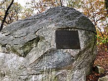
Glover's Rock (40°51′54″N 73°48′19″W / 40.86507°N 73.805244°W), a giant granite glacial erratic, has a bronze plaque commemorating the Battle of Pell's Point.[20] However, contrary to popular belief, the rock had nothing to do with the battle.[167] In their respective books, Henry B. Dawson (1886) and William Abbatt (1901) both wrote that Colonel John Glover reputedly stood on the rock and watched the British forces land during the battle.[168][30]: 255 This claim is erroneous, as these distances were computed based on an inaccurate map using estimates recorded by Glover in his "Letter from Mile Square" on October 24, 1776.[167] The actual location where Glover watched British forces land is closer to the second tee of the current Split Rock Golf Course.[167] The rock is only known as such today because Abbatt includes a labeled photograph of it in his book.[30]: 4
Split Rock
[edit]Split Rock (40°53′11″N 73°48′54″W / 40.88648°N 73.81492°W), a large dome-shaped granite boulder measuring approximately 25 feet (7.6 m) from north to south and 15 feet (4.6 m) from east to west, is located at the intersection of the New England Thruway and Hutchinson River Parkway, on a triangular parcel of land formed by these roads and a ramp that leads from the northbound Parkway to the northbound Thruway.[169] The only public access to the rock is by a pedestrian trail that begins on Eastchester Place, outside the park. The Bridle Trail passes close to the rock, but is separated from the rock by the parkway's exit ramp.[135] Another park trail, called the Split Rock Trail, leads from the Bartow Circle to the rock.[170]

The Split Rock Golf Course was named after the rock.[2] Split Rock also gives its name to Split Rock Road in Pelham Manor,[171] which used to extend into the park itself.[172] The rock appears to be a glacial erratic and derives its name from a large crevice dividing the stone into two half domes. The huge rock broke in half about 10,000 years ago under the stress of glacial movements.[173][174]
Split Rock is also the location near where, in 1643, Anne Hutchinson and members of her family were massacred by Native Americans of the Siwanoy Tribe. Her daughter, Susanna, the only member of the family to survive the massacre, was at the rock during the time of the attack, which took place at the house, a distance away.[16]: 237 In 1904, the New York State Legislature approved the placement of a bronze tablet on Split Rock in honor of Anne Hutchinson.[175] The tablet was installed in 1911 by the Colonial Dames of New York.[176][177] However, it was stolen in 1914.[178][179] The plaque reads:[179][180]
ANNE HUTCHINSON
Banished from the Massachusetts Bay Colony in 1638[b]
Because of her Devotion to Religious Liberty This Courageous Woman
Sought Freedom from Persecution in New Netherland
Near this Rock in 1643 She and her Household
were Massacred by Indians
This Tablet is placed here by the Colonial Dames of the State of New York
ANNO DOMINI MCMXI Virtutes Majorum Filiae Conservant[180]
The boulder is of enough historic importance that in the 1950s, Theodore Kazimiroff of the Bronx Historical Society convinced officials to move the planned Interstate 95 (New England Thruway) a few feet north to save Split Rock from being dynamited.[181][182]
Treaty Oak
[edit]Treaty Oak (40°52′16″N 73°48′14″W / 40.871°N 73.804°W) is located on the Pell estate near the Bartow-Pell Mansion. A treaty was reportedly signed under this oak tree in 1654 between Siwanoy Chief Wampage and colonist Thomas Pell, in which Pell purchased all land east of the Bronx River in what was then Westchester County, New York.[13] The Society of the Daughters of the Revolution erected a protective fence and a plaque near the tree, but it was destroyed by lightning in 1906[183][13] and toppled in a storm in March 1909.[184] Parts of the original tree were donated to museums and historical societies.[185]
A replacement tree was planted in 1915,[186] and the current tree at the location is an elm.[187]
Wildlife sanctuaries
[edit]Thomas Pell Wildlife Sanctuary and the Hunter Island Marine Zoology and Geology Sanctuary consist of a total of 489 acres (1.98 km2) of marshes and forests within Pelham Bay Park. They were created in 1967 as a result to opposition to a planned landfill on the site of the current sanctuaries.[188] Much of the forests in these sanctuaries are estimated to be at least three centuries old, dating to colonial times.[189] The park also has two nature centers at Orchard Beach and in the southwestern section of the park.[133][190]
Thomas Pell Wildlife Sanctuary
[edit]The Thomas Pell Wildlife Sanctuary, named for Thomas Pell, makes up the westerly part of Pelham Bay Park.[191] Included within its bounds are Goose Creek Marsh, which once formed part of a 5,000-acre (2,000 ha) wetland that covered what is now Co-op City and the southern part of Pelham Bay Park,[192] as well as the saltwater wetlands adjoining the Hutchinson River.[135] The sanctuary also includes Goose Island, Split Rock, and the oak–hickory forests in tidal marshes bordering the Split Rock Golf Course.[193] The area is home to a variety of wildlife including raccoon, egrets, hawks, and coyotes.[133]
Hunter Island Marine Zoology and Geology Sanctuary
[edit]Located north of Orchard Beach, the Hunter Island Marine Zoology and Geology Sanctuary encompasses all of Twin Islands, Cat Briar Island, Two Trees Island, and the northeastern shoreline of Hunter Island.[194][195] It contains many glacial erratics, large boulders that were deposited during the last ice age,[194][193] as well as the largest continuous oak forest in Pelham Bay Park. The sanctuary supports a unique intertidal marine ecosystem that is rare in New York State.[133][81][146]
Wildlife-related activities
[edit]
The park is a popular spot for bird watching, with up to 264 species having been spotted. Common bird species observed within the park include great horned owl, northern saw-whet owl, barn owl, red-tailed hawk, and warblers on Hunter Island;[196] American woodcock, willow flycatcher, northern harrier, woodpeckers, black-capped chickadee, tufted titmouse, and white-breasted nuthatch in the meadow west of Orchard Beach;[197] and various songbirds and sparrows north of the Pelham Bay Golf Course.[198] Birds in the park's waters include loons, grebes, cormorants, anseriformes, and gulls from the Twin Island coasts;[199] greater yellowlegs, lesser yellowlegs, loons, hooded merganser, Canada goose, mallard, and egrets in Eastchester Bay and Turtle Cove;[198] and osprey and waterbirds in the lagoon.[200] This is a result of Pelham Bay Park's location within one of the major seasonal bird migration corridors. The National Audubon Society has designated the park as one of four "Important Bird Areas" within the city.[201][202]
Saltwater fishing is also popular within the park, but is prohibited on Orchard Beach when the beach is open during the summer.[202] There are two major areas where fishing is allowed: in the southern part of Pelham Bay Park near Eastchester Bay; and in the northern part near the Lagoon, Turtle Cove, and northern beach jetty.[203]
South of Orchard Beach is a 25-acre (10 ha) meadow that hosts the only known population of the moth species Amphipoea erepta ryensis.[133][204][205] Another population used to exist in Rye, Westchester County.[206][207]
Surroundings
[edit]Pelham Bay Park is bounded by the town of Pelham, New York, to the north; City Island and Long Island Sound to the east; Watt Avenue and Bruckner Expressway to the south; and the Hutchinson River Parkway to the west.[2][135]
North of the park is the village of Pelham Manor in Westchester County, and a 250-foot-wide (76 m) strip of land that is part of New York City due to a boundary error. Owners of the several dozen houses on the strip have a Pelham Manor zip code and phone numbers and their children attend Pelham public schools, but as Bronx residents pay much lower property taxes than their Westchester County neighbors.[208]
To the southeast, the City Island Bridge connects the park to City Island.[209][210]
Landmarks, attractions, and recreational features
[edit]Orchard Beach
[edit]
Orchard Beach (40°52′02″N 73°47′45″W / 40.867304°N 73.795946°W), a public beach, is part of Pelham Bay Park[68] and comprises the borough's only beach.[92] The 1.1-mile-long (1.8 km), 115-acre (47 ha)[211] beach faces the Long Island Sound and is laid out in a crescent shape with a width of 200 feet (61 m) during high tide.[212] An icon of the Bronx, Orchard Beach is sometimes called the Bronx Riviera,[92][213][214][215] the Riviera of New York City,[216] Hood Beach,[215] or the Working Class Riviera.[217] It contains a set of twin pavilions, which were both landmarked by the New York City Landmarks Preservation Commission in 2006.[218]
Bronx Victory Column & Memorial Grove
[edit]
The Bronx Victory Column & Memorial Grove is a 70-foot-tall (21 m) limestone column that supports a bronze statue of Winged Victory on Crimi Road in the park. The grove of trees that surround the statue were originally planted on the Grand Concourse in 1921 by the American Legion;[219] they were removed in 1928 when construction began on the IND Concourse Line (B and D trains).[220] In 1930, the American Legion revealed plans to relocate the grove to Pelham Bay Park, where there would be a new monument to honor Bronx servicemen. The monument was designed by John J. Sheridan and sculpted by Belle Kinney and Leopold Scholz.[220][219] On September 24, 1933, the monument and grove was dedicated to the 947 Bronxites who died in World War I.[220][221] The column is supported by a 18-foot-tall (5.5 m) pedestal. The statue itself is 18 feet tall and 3,700 pounds (1,700 kg), located atop a series of 14 discs. This brings the monument's aggregate height to more than 120 feet (37 m).[221] While officially a memorial to servicemen from the Bronx,[220] it is also a favorite location for wedding photography.[222]
Bartow-Pell Mansion
[edit]A 19th-century plantation-style mansion called the Bartow–Pell Mansion (located at 40°52′18″N 73°48′21″W / 40.871611°N 73.805944°W) is a colonial remnant done in Greek revival style.[223][32] The mansion, originally built in 1842, was sold to the city in 1880, which maintained it until 1914, when the city and International Garden Club assumed joint maintenance of the building.[32][33] Since 1975, it has been a National Historic Landmark.[224][33]
Pelham Bay and Split Rock Golf Courses
[edit]The Pelham Bay Golf Course opened in 1901, followed by the Split Rock Golf Course in 1935.[83] The courses, consisting of eighteen holes each, share an Art Deco clubhouse (located at 40°52′30″N 73°48′35″W / 40.874967°N 73.80972°W).[225] The courses are separated by the Northeast Corridor railroad tracks, with the Split Rock course to the northwest and the Pelham Bay course to the southeast.[135]
Plans for a golf course in Pelham Bay Park have existed since soon after the park was founded. In 1899, the New York Athletic Club approached Lawrence Van Etten, an architect renowned for designing golf courses, for a request to construct an 18-hole course within the park.[83] The proposed course would be bounded by Pelham Manor to the north; the Harlem River and Port Chester Railroad (now Northeast Corridor) tracks to the west; and Shore Road to the southeast. The city was building Van Cortlandt Park's golf course at the time, but the Bronx district parks commissioner approved Van Etten's plan. Originally, the club wanted to construct a park on Hunter Island, but Van Etten felt that the island was too small for a full 18-hole course.[226] Once the Van Cortlandt Park course was opened, city officials started focusing on plans for the Pelham course.[227]

In April 1900, surveyors began studying part of the park as a possible location for a golf course.[228][227] Later that month, workers began construction at the northwest course location. It was expected that the course would open in June or July of that year,[228][229] but that the work would not be fully complete until September.[227] New York City greenskeeper Val Flood later stated that he thought the course would open by August; however, by September 1900, work on the course had hardly started due to a lack of workers.[230] By the end of 1900, NYC Parks reported that seeds had been planted for nine greens, and two bunkers and one hazard had been created.[64]: 23 The course opened in 1901,[65]: 69 but did not gain popularity until 1903 when overcrowding at the Van Cortlandt course drove players to use the less crowded Pelham Bay course instead.[231]
In 1934, a new 18-hole course was announced for the north side of the park, along with a renovation to the Pelham Bay course under the WPA.[73][232] It was part of the rebuilding of 10 golf courses in the city.[233] The new course brought the total number of holes in the park's courses to 36, with each course being between 3,000 and 3,300 feet (910 and 1,010 m) between the first and last tees. This comprised two 18-hole courses or four 9-hole courses. There was also a new two-story brick Greek Revival clubhouse adjacent to both of the 18-hole courses, with a golf store, Pro Shop, cafeteria, lockers, restrooms, and showers. Construction started on the new course and clubhouse in September 1934.[234] The new Split Rock course, based on a plan from John van Kleek, opened in 1935[83] along with the rebuilt Pelham Bay course.[82]
Bronx Equestrian Center
[edit]The northern section of Pelham Bay Park is the home of the Bronx Equestrian Center on Shore Road, where visitors can ride horses and ponies through the parks' trails or obtain riding lessons.[235][131] The Bronx Equestrian Center also provides wagon rides and hosts wedding events.[131]
Southwestern section
[edit]The southwestern part of Pelham Bay Park contains several recreational facilities, but unlike the rest of the park, the southwestern section mainly serves the nearby neighborhoods.[4][236] The southwest park's largest point of interest is the Aileen B. Ryan Recreational Complex, which contains a running track, two baseball fields, and the Playground for All Children, a play area with special features for physically handicapped children.[237] Another playground, the Sweetgum Playground, is located near Bruckner Boulevard. The 0.25-mile (0.40 km) Pelham Track and Field includes an artificial turf football field as well as long jumping.[219] The southwest park also contains a dog run, four more baseball fields (for a total of six), two bocce courts, several basketball courts, and nine tennis courts.[238] This section of the park also includes the Pelham Bay Nature Center.[219] The neighborhood of Pelham Bay is across the Bruckner Expressway from this section of the park.[4]
A long and narrow 41-acre (17 ha) woodland called Huntington Woods, located on the southern border of this park, is named after the tract's last owners. Archer Milton Huntington, the founder of the Hispanic Society of America, and his wife, sculptor Anna Hyatt Huntington, had acquired the property in 1896 after the park had been established. The city added 31.6 acres (12.8 ha) of Huntington's estate to the park in 1925 and annexed the remaining land in 1933.[239]
The southwestern park also contains two monuments. American Boy was commissioned in 1923 by French sculptor Louis St. Lannes and carved from one block of Indiana Limestone.[237] A tribute to the athletic body, it once stood outside the Rice Stadium and Recreation Building; the stadium, named and funded by the widow of Isaac Leopold Rice, stood at the site from the 1920s until 1989. The former stadium site is now the Pelham Track and Field.[237][240] The other is the Bronx Victory Column & Memorial Grove.[219][221][220]
Management
[edit]A nonprofit organization called Friends of Pelham Bay Park (founded in 1992) manages the park, while NYC Parks owns and operates the land and facilities.[241] Compared to the Central Park Conservancy, Friends of Pelham Bay Park does not receive as much funding.[242] Before 1992, there was no private maintenance of the park;[243] the earliest efforts for such a thing date to 1983, when an administrator was appointed to oversee both Van Cortlandt and Pelham Bay Parks.[244]
Transportation
[edit]Bridges
[edit]
As part of the city's acquisition of Pelham Bay Park in 1888, NYC Parks claimed responsibility for maintenance over the western end of the City Island Bridge, which was within the park.[245]: 433 (PDF p.502) [51]: 695 The City Island Bridge had been built by the 1870s.[246] By 1892, the bridge was in need of maintenance,[60]: PDF p.114 and a proposal for a replacement bridge was approved in 1895.[62]: 41 (PDF p.115) The replacement bridge started construction in late 1898 and was completed in 1901.[247]
The Pelham Bridge, which had opened in 1871 on the site of two previous bridges,[248] was also incorporated into the park.[62]: PDF p.443 [51]: 695 Planning for a new bridge started in 1901,[65]: 64 and NYC Parks transferred the responsibility for constructing the new bridge to the Department of Bridges in 1902.[66]: 117 (PDF p.86) A new stone bridge was opened in 1908 to accommodate higher volumes of traffic.[249][250]
The century-old City Island Bridge was subsequently replaced again in the 2010s. Planning for the new bridge started in 2005,[251] though a lack of funding delayed the start of construction to 2012.[252] The new bridge was completed in 2015, and the old one was demolished soon after.[253]
Roads
[edit]
The park is traversed by the Hutchinson River Parkway on its west side.[3] The New England Thruway (I-95), a partial toll road, also has a short highway section in the park's northwest corner.[209][135] A partial interchange between the two roads is located within the park.[209] To the south, an exit from the Hutchinson River Parkway provides direct access to the park, Orchard Beach, and City Island. The exit and entrance ramps lead east to the Bartow Circle, where the ramps intersect with Shore Road, which runs roughly southwest-northeast, and with Orchard Beach Road, which leads southeast to the Orchard Beach parking lot.[209] Slightly to the southwest of Bartow Circle is the T intersection of Shore Road and City Island Road, which marks the northwest terminus of the latter road. Shore Road continues across the Pelham Bridge to the southwest corner of the park, then turns west and continues onto Pelham Parkway.[209] Meanwhile, City Island Road continues southeast to City Island Circle, where it intersects with Park Drive, a road that connects to Orchard Beach Road in the north and Rodman's Neck in the south. City Island Road then continues southeast across the City Island Bridge to the eponymous island.[209]
NYC Parks assumed responsibility for the park's roads in 1888 and gradually paved and expanded them over the following decades.[51]: 695 An expansion of Eastern Boulevard (later Shore Road) began in 1895.[62]: PDF p.175 In 1897, the city started extending Pelham Parkway through to Eastern Boulevard.[254]: 258 (PDF p.328) By 1902, Eastern Boulevard was referred to as "the Shore drive" since it ran close to the LeRoy's Bay shore. The same year, NYC Parks built a 4,230-foot (1,290 m) dirt path, which connected Glover's Rock to Shore Road. Another 4,870-foot-long (1,480 m) dirt road to Pelham Bridge was also built, and a 6,485-foot (1,977 m) pedestrian path from City Island Bridge to Bartow Station was built.[66]: 116–117 (PDF pp.85–86)
The Hutchinson River Parkway in Pelham Bay Park replaced the old Split Rock Road in the park. The original roadway was an undivided, limited-access parkway, designed with gently sloping curves, stone arch bridges, and wooden lightposts. The original 11-mile (18 km) section included bridle paths along the right-of-way. There was also a riding academy where the public could rent horses.[255] The parkway is named for Anne Hutchinson and her family, and passes through the part of the park near where the Hutchinsons were killed by the Siwanoy.[255] The modern-day parkway was extended south from Westchester through Pelham Bay Park in December 1937.[256][172]
The second highway through the park, the New England Thruway, opened in its entirety in October 1958, connecting the Bruckner Expressway in the south with the Connecticut Turnpike in the northeast.[257]
Public transport
[edit]
Pelham Bay Park is served by the New York City Subway at its eponymous station on the west side of the Bruckner Expressway,[258] which is served by the 6 and <6> trains.[259] The station is part of the former Interborough Rapid Transit Company (IRT)'s Pelham Line. The line's northern terminus is located at the southeast corner of Pelham Bay Park, and the IRT station there opened in December 1920.[260][261] An exit from the station leads onto a pedestrian bridge that crosses the expressway and leads directly to the park.[236][258]
MTA Regional Bus Operations компании Маршрут Bx29 и маршрут 45 компании Bee-Line Bus System также останавливаются в парке. [ 262 ] Автобус Bx29, идущий на юг, делает три остановки в парке: на бульваре Брукнера возле станции метро; на пересечении улиц Шор-Роуд и Сити-Айленд-Роуд; и в City Island Circle. [ 263 ] Тем временем 45-й маршрут «Би-Лайн» останавливается возле особняка Бартоу-Пелла. [ 236 ] Автобус Bx12 обслуживает Орчард-Бич только летом. [ 264 ]
Железные дороги
[ редактировать ]Железная дорога Гарлем -Ривер и Порт-Честер была зафрахтована в 1866 году. [ 265 ] соединяющий реку Гарлем на юге и Порт-Честер на севере. Железная дорога открылась в 1873 году, некоторые ее участки проходили через нынешний парк. [ 266 ] Маршрут, ответвление линии Нью-Хейвен, которым управляет железная дорога Нью-Йорка, Нью-Хейвена и Хартфорда , состоял из шести станций. Одна из этих станций, называемая также City Island или Bartow, в Пелхэме (ныне часть парка). [ 267 ] В 1895 году железная дорога выкупила часть земли у парка. [ 153 ] : 205 (PDF стр. 297) В 1906 году право собственности на эстакаду Шор-Роуд через железнодорожную линию Гарлема и Порт-Честера было передано железной дороге Нью-Йорка, Нью-Хейвена и Хартфорда. [ 268 ]
также Какая-то железная дорога соединяла Сити-Айленд и парк Пелхэм-Бэй с 1887 по 1919 год. Первоначально состоявшая из отдельной железнодорожной компании Пелхэм-Парк и Сити-Айлендской железной дороги, маршрут длиной 3 фута 6 дюймов ( 1067 мм ) узкоколейный эксплуатировался компанией первая из двух компаний, которая обеспечивала сообщение между станцией Бартоу на реке Гарлем и железной дорогой Порт-Честер и отелем Брауна на Сити-Айленде. Маршрут протяженностью 3,2 мили (5,1 км) был завершен к 1892 году. [ 269 ] IRT поглотила обе компании в 1902 году и начала проектировать собственную монорельсовую дорогу в 1908 году. [ 269 ] [ 270 ] Первое путешествие монорельса в июле 1910 года закончилось тем, что монорельс упал на бок. [ 271 ] [ 272 ] [ 270 ] монорельс был передан в управление . и хотя движение возобновилось в ноябре 1910 года, в декабре 1911 года [ 273 ] Монорельс прекратил работу 3 апреля 1914 года. [ 274 ] [ 275 ] [ 276 ] и впоследствии был продан железной дороге Третьей авеню , [ 277 ] который покинул линию 9 августа 1919 года. [ 278 ]
Железнодорожные пути Гарлем-Ривер и Порт-Честер обслуживались железной дорогой Нью-Йорка, Нью-Хейвена и Хартфорда. [ 279 ] : 1092 Новые станции, спроектированные Кассом Гилбертом, были открыты в 1908 году, но все станции линии были закрыты к 1937 году из-за низкой посещаемости. [ 276 ] В конце 20-го века старые пути Гарлем-Ривер и Порт-Честер претерпели ряд смен владельцев, а в 1976 году компания Amtrak купила эти пути и интегрировала их в свой Северо-восточный коридор . [ 279 ] : 81 Здание станции Бартоу на линии все еще существует, хотя и в виде ветхого корпуса; [ 280 ] крыша станции сгорела после ее закрытия. [ 276 ] От конюшней к бывшей станции ведет заросшая тропа. [ 281 ]
В начале 2000-х годов город отремонтировал железнодорожную эстакаду Шор-Роуд. Ссылаясь на акт 1906 года, согласно которому обслуживание моста было передано компании, владевшей железной дорогой под ним, город затем подал иск, чтобы заставить Amtrak оплатить ремонт. Окружной суд США по округу Колумбия вынес решение в пользу Amtrak в 2013 году. [ 268 ] [ 282 ]
Пути
[ редактировать ]Велосипедные дорожки ведут ко всем частям парка и на запад к Бронкс-парку , на восток к Сити-Айленду и на север к Маунт-Вернон. [ 283 ] Велосипедные дорожки внутри самого парка имеют разную сложность. [ 131 ]
Живописные тропы
[ редактировать ]Природная тропа Казимирова — тропа для наблюдения за дикой природой, открытая в 1986 году. [ 115 ] [ 114 ] Он пересекает 189 акров (76 га) острова Хантер. Вдоль тропы можно увидеть большую часть природных особенностей острова. [ 284 ] Он был открыт в 1986 году. [ 115 ] и состоит из двух перекрывающихся дорожек в форме лассо, одна немного длиннее другой. [ 114 ] [ 284 ]
Тропа Сиваной представляет собой систему троп, берущую начало в центральной части парка. Беря начало у Сити-Айленд-роуд, он ведет на северо-восток, а затем разделяется на два отрога: один идет на восток к лугу Родманс-Нек, а другой идет на север вокруг круга Бартоу. На восточной стороне круга тропа снова разделяется. Один отъезд идет на северо-восток по самозамыкающейся петле к особняку Бартоу-Пелла, а другой идет на северо-запад, чтобы соединиться с тропой Сплит-Рок, прежде чем объехать развязку бульвара Хатчинсон-Ривер с Орчард-Бич-роуд. [ 135 ]
Тропа Сплит-Рок берет свое начало у Бартоу-Серкл и тянется на 1,5 мили (2,4 км) вдоль западной стороны парка. [ 135 ] [ 170 ] [ 194 ] Впервые обозначен в 1938 году на месте бывшей дороги Сплит-Рок. [ 172 ] Дорога была отремонтирована летом 1987 года. [ 170 ]
Через парк также проходит конная тропа. [ 2 ] Этот путь огибает оба поля для гольфа и ведет к конному центру Бронкса. [ 135 ]
Ссылки
[ редактировать ]Примечания
[ редактировать ]- ^ Jump up to: а б с Точный размер оспаривается: в некоторых источниках указывается 2764 акра (1119 га). [ 1 ] [ 2 ] 2765 акров (1119 га), [ 3 ] или 2772 акра (1122 га). [ 4 ] Пересчет размеров городского парка в 2013 году показал, что площадь парка Пелхэм-Бэй составляла 2772 акра. [ 5 ]
- ^ The New York Times цитирует эту строку как «Колонии Массачусетса», а не как «Колония Массачусетского залива». [ 179 ]
Цитаты
[ редактировать ]- ^ Комиссия по сохранению достопримечательностей, 2006 г. , с. 13.
- ^ Jump up to: а б с д и ж г Джексон 2010 , с. 986.
- ^ Jump up to: а б с д и ж г Смит, Сара Харрисон (2013). «Изучение песка и архитектуры в парке Пелхэм-Бэй» . Нью-Йорк Таймс . ISSN 0362-4331 . Архивировано из оригинала 2 октября 2017 года . Проверено 2 октября 2017 г.
- ^ Jump up to: а б с Грегор, Элисон (27 апреля 2014 г.). «Пелхэм-Бэй, Бронкс: смесь городского и пригородного» . Нью-Йорк Таймс . Архивировано из оригинала 6 октября 2017 года . Проверено 5 октября 2017 г.
- ^ Jump up to: а б с Фодераро, Лиза В. (31 мая 2013 г.). «Насколько велик этот парк? Теперь у города есть ответ» . Нью-Йорк Таймс . Архивировано из оригинала 1 июня 2013 года . Проверено 31 мая 2013 г.
- ^ О'Хи Андерсон 1996 , с. 4.
- ^ Департамент парков Нью-Йорка, 1987 , с. 2.
- ^ Jump up to: а б О'Хи Андерсон 1996 , с. 5.
- ^ Jump up to: а б с д «Основные моменты парка Пелхэм-Бэй: парки Нью-Йорка» . Департамент парков и отдыха города Нью-Йорка . 29 сентября 2006 года. Архивировано из оригинала 27 мая 2016 года . Проверено 5 октября 2017 г.
- ^ «Сиваной Тропа» . Департамент парков и отдыха города Нью-Йорка . 20 марта 1989 года. Архивировано из оригинала 1 октября 2017 года . Проверено 13 сентября 2017 г.
- ^ Jump up to: а б Лесли Дэй (10 мая 2013 г.). «Глава 2: Бронкс» . Путеводитель по миру природы Нью-Йорка . Джу Пресс. ISBN 978-1-4214-1149-1 .
- ^ Jump up to: а б с Стивенс, Дж.А.; ДеКоста, БФ; Джонстон, HP; Лэмб, MJ; Пруд, Нью-Йорк; Эббатт, В. (1892). Журнал американской истории с примечаниями и вопросами . АС Барнс. п. 408 . Проверено 5 октября 2017 г.
- ^ Jump up to: а б с д и ж г Туми 2007 , с. 212.
- ^ «Памятники парка Оуэна Ф. Долена» . Департамент парков и отдыха города Нью-Йорка . 30 апреля 1926 года. Архивировано из оригинала 6 октября 2017 года . Проверено 6 октября 2017 г.
- ^ Jump up to: а б Чамплин, Джон Денисон (1913). «Трагедия Энн Хатчинсон». Журнал американской истории . 5 (3): 11.
- ^ Jump up to: а б с д ЛаПланте, Ева (2004). Американская Иезавель, необычная жизнь Энн Хатчинсон, женщины, бросившей вызов пуританам . Сан-Франциско: Харпер Коллинз. ISBN 0-06-056233-1 . Архивировано из оригинала 8 мая 2022 года . Проверено 25 октября 2016 г.
- ^ Барр 1946 , с. 5.
- ^ Андерсон, Роберт Чарльз (2003). Великая миграция, иммигранты в Новую Англию 1634–1635 гг . Том. III ГХ. Бостон: Историческое генеалогическое общество Новой Англии . стр. 479–481. ISBN 0-88082-158-2 .
- ^ Дарлин Р. Стилл (август 2006 г.). Энн Хатчинсон: пуританский протестующий . Замковый камень. стр. 85–88. ISBN 978-0-7565-1784-7 .
- ^ Jump up to: а б с «Военный рекорд парка Пелхэм-Бэй; Военный рекорд парка Пелхэм-Бэй» (PDF) . Нью-Йорк Таймс . 14 августа 1921 г. ISSN 0362-4331 . Архивировано (PDF) из оригинала 8 мая 2022 г. Проверено 2 октября 2017 г.
- ^ Jump up to: а б с Пелл 1917 , с. 5.
- ^ Jump up to: а б Дженкинс 2007 , с. 35.
- ^ О'Хи Андерсон 1996 , с. 12.
- ^ Пелл 1917 , с. 12.
- ^ Пелл 1917 , с. 16.
- ^ Годовой отчет ASHPS за 1909 год , стр. 63.
- ^ Дженкинс 2007 , с. 313.
- ^ Маккалоу, Дэвид (2006). 1776 . Нью-Йорк: Саймон и Шустер в мягкой обложке. п. 209 . ISBN 0-7432-2672-0 .
- ^ Jump up to: а б Уорд, Кристофер (1952). Война за революцию, Том 1 . Нью-Йорк: Компания Macmillan.
- ^ Jump up to: а б с д Эббатт, Уильям (1901). Битва при Пеллс-Пойнт . Нью-Йорк: Калифорнийский университет.
- ^ Джексон 2010 , с. 161.
- ^ Jump up to: а б с д и Грей, Кристофер (28 апреля 2002 г.). «УЛИЧНЫЕ ПЕЙЗАЖИ / Особняк БАРТОУ-ПЕЛЛА В БРОНКСЕ; дом 1842 года, ныне музей, в самом большом парке города» . Нью-Йорк Таймс . ISSN 0362-4331 . Архивировано из оригинала 3 октября 2017 года . Проверено 2 октября 2017 г.
- ^ Jump up to: а б с Кастеллуччи, Джон (18 марта 1977 г.). «Теперь официальная достопримечательность особняка Садового клуба» (PDF) . Ежедневные новости . Тэрритаун, Нью-Йорк . п. А5. Архивировано (PDF) из оригинала 8 мая 2022 г. Проверено 2 октября 2017 г. - через Fultonhistory.com .
- ^ Олмстед, Фредерик Лоу; Во, Калверт; Крус, Джон Джеймс Робертсон (1968). Фейн, Альберт (ред.). Пейзаж в городской пейзаж: планы Фредерика Лоу Олмстеда по созданию большего Нью-Йорка . Издательство Корнельского университета. п. 331. ИСБН 9780442225391 .
- ^ Гонсалес 2004 , с. 47.
- ^ Голан, Майкл (1975). «Парки Бронкса: чудо из прошлого». Журнал Исторического общества округа Бронкс . 12 (2). Историческое общество округа Бронкс : 32–41.
- ^ Гонсалес 2004 , с. 49.
- ^ «НЕОБХОДИМОСТЬ БОЛЬШИХ ПАРКОВ; ПЕРВАЯ ВСТРЕЧА НЬЮ-ЙОРКСКОЙ АССОЦИАЦИИ ПАРКОВ ВЧЕРА» (PDF) . Нью-Йорк Таймс . 27 ноября 1881 г. ISSN 0362-4331 . Архивировано (PDF) оригинала 24 сентября 2021 г. Проверено 4 октября 2017 г.
- ^ Департамент парков Нью-Йорка и Storch Associates 1986a , с. 3.
- ^ «Законодатели Олбани» (PDF) . Нью-Йорк Таймс . Олбани, Нью-Йорк . 25 марта 1884 г. Архивировано (PDF) из оригинала 24 сентября 2021 г. . Проверено 8 января 2017 г.
- ^ Jump up to: а б Департамент парков Нью-Йорка и Storch Associates, 1986a , с. 56.
- ^ Маллали, Джон (1887). Новые парки за пределами Гарлема: с тридцатью иллюстрациями и картой. Описания пейзажей. Почти 4000 акров бесплатной игровой площадки для людей . Нью-Йорк: Набу Пресс. стр. 117–138 . ISBN 978-1-141-64293-9 .
- ^ «Губернатор Кливленд и законопроекты» . Солнце . 15 июня 1884 г. с. 4 . Проверено 30 ноября 2023 г.
- ^ Jump up to: а б Департамент парков Нью-Йорка и Storch Associates, 1986a , стр. 57–58.
- ^ Jump up to: а б с д и ж г Комиссия по сохранению достопримечательностей 2006 , с. 3.
- ^ Jump up to: а б «Пелхэм так же устал от парка, как и мы» . Нью-Йорк Сан . 25 марта 1887 г. с. 4. Архивировано из оригинала 6 октября 2017 года . Проверено 6 октября 2017 г. - из Библиотеки Конгресса .
- ^ «ПЕЛХАМ В ОТЧАЯНИИ; ПРЕДВИДЕНИЕ БАНКРОТСТВА ЧЕРЕЗ СХЕМУ ПАРКА» (PDF) . Нью-Йорк Таймс . 5 февраля 1888 г. ISSN 0362-4331 . Архивировано (PDF) из оригинала 8 мая 2022 г. Проверено 6 октября 2017 г.
- ^ «ПАРК ПЕЛХЭМ. ЖИТЕЛИ ВЕСТЧЕСТЕРА ПРОСЯТ ПОМОЩИ МЭРА ХЬЮИТТА, ЧТОБЫ ПРЕКРАТИТЬ СХЕМУ» (PDF) . Нью-Йорк Таймс . 25 марта 1887 г. ISSN 0362-4331 . Архивировано (PDF) из оригинала 8 мая 2022 г. Проверено 6 октября 2017 г.
- ^ «Жестко с Пелхэмом, но должны ли мы за это платить?» . Солнце . 5 февраля 1888 г. с. 11. ISSN 1940-7831 . Архивировано из оригинала 8 октября 2017 года . Проверено 7 октября 2017 г. - из Библиотеки Конгресса .
- ^ «ОБЛОЖИТЬ НАЛОГОМ ПАРК ПЕЛХЭМ-БЭЙ — ПЫТКА СИЛЬНО ИСТЕЧИТЬ НЬЮ-ЙОРК — ПОЧТИ БЕСПОЛЕЗНЫЙ ПАРК, КОТОРЫЙ МОЖЕТ ПРИБЛИЖАТЬСЯ — ДВЕ СТОРОНЫ ИСТОРИИ» . Нью-Йорк Трибьюн . 5 февраля 1888 г. ISSN 1941-0646 . Архивировано из оригинала 8 ноября 2017 года . Проверено 7 октября 2017 г. - из Библиотеки Конгресса .
- ^ Jump up to: а б с д и Законы штата Нью-Йорк: приняты на сессии Законодательного собрания . Законы Нью-Йорка. Законодательное собрание штата Нью-Йорк. 1888. стр. 693–696. hdl : 2027/nyp.33433090742036 . Архивировано из оригинала 8 мая 2022 года . Проверено 16 октября 2017 г. - через HathiTrust.
- ^ Джексон 2010 , с. 987.
- ^ Jump up to: а б с д Парк Пелхэм-Бэй: История (Отчет). Нью-Йорк: Город Нью-Йорк . 1986. стр. 2, 11–12.
- ^ Годовой отчет ASHPS за 1909 год , стр. 64–66.
- ^ «Суды» . Нью-Йорк Трибьюн . 16 марта 1889 г. с. 4. Архивировано из оригинала 6 октября 2017 года . Проверено 6 октября 2017 г. - из Библиотеки Конгресса .
- ^ «ПЕЛХЭМ БЭЙ ПАРК» (PDF) . Нью-Йорк Таймс . 30 августа 1889 г. ISSN 0362-4331 . Архивировано (PDF) из оригинала 8 мая 2022 г. Проверено 3 октября 2017 г.
- ^ Болотин, Норм; Лэнг, Кристина (1992). Всемирная выставка в Колумбии: Всемирная выставка в Чикаго 1893 года . Издательство Университета Иллинойса. п. 3. ISBN 9780252070815 .
- ^ «Совет уполномоченных Департамента общественных парков Нью-Йорка – Протоколы и документы: Протоколы и документы: 8 мая 1889 г. – 30 апреля 1890 г.» (PDF) . Департамент парков и отдыха Нью-Йорка. 30 апреля 1890 г. Архивировано (PDF) из оригинала 3 февраля 2018 г. . Проверено 13 января 2017 г.
- ^ «Совет уполномоченных Департамента общественных парков Нью-Йорка – протоколы и документы: 13 мая 1891 г. – 28 апреля 1892 г.» (PDF) . Департамент парков и отдыха Нью-Йорка. 30 апреля 1892 года. Архивировано (PDF) из оригинала 3 февраля 2018 года . Проверено 13 января 2017 г.
- ^ Jump up to: а б «Совет уполномоченных Департамента общественных парков Нью-Йорка – протоколы и документы: 4 мая 1892 г. – 26 апреля 1893 г.» (PDF) . Департамент парков и отдыха Нью-Йорка. 30 апреля 1893 года. Архивировано (PDF) из оригинала 3 февраля 2018 года . Проверено 13 января 2017 г.
- ^ «Совет уполномоченных Департамента общественных парков Нью-Йорка – протоколы и документы: 1 мая 1893 г. – 25 апреля 1894 г.» (PDF) . Департамент парков и отдыха Нью-Йорка. 30 апреля 1894 года. Архивировано (PDF) из оригинала 3 февраля 2018 года . Проверено 13 января 2017 г.
- ^ Jump up to: а б с д «Совет уполномоченных Департамента общественных парков Нью-Йорка – протоколы и документы: 2 мая 1894 г. – 25 апреля 1895 г.» (PDF) . Департамент парков и отдыха Нью-Йорка. 30 апреля 1895 г. Архивировано (PDF) из оригинала 3 февраля 2018 г. Проверено 13 января 2017 г.
- ^ Jump up to: а б «Годовой отчет Департамента общественных парков Нью-Йорка за 1899 год» (PDF) . nyc.gov . Департамент парков и отдыха города Нью-Йорка . 31 декабря 1899 года. Архивировано (PDF) из оригинала 11 февраля 2017 года . Проверено 11 января 2017 г.
- ^ Jump up to: а б «Годовой отчет Департамента общественных парков Нью-Йорка за 1900 год» (PDF) . nyc.gov . Департамент парков и отдыха города Нью-Йорка . 1900. Архивировано (PDF) из оригинала 1 февраля 2017 года . Проверено 13 января 2017 г.
- ^ Jump up to: а б с «Годовой отчет Департамента общественных парков Нью-Йорка за 1901 год» (PDF) . nyc.gov . Департамент парков и отдыха города Нью-Йорка . 1901. Архивировано (PDF) из оригинала 18 января 2017 года . Проверено 13 января 2017 г.
- ^ Jump up to: а б с «Годовой отчет Департамента общественных парков Нью-Йорка за 1902 год (часть 2)» (PDF) . nyc.gov . Департамент парков и отдыха города Нью-Йорка . 1902. Архивировано из оригинала (PDF) 16 января 2017 года . Проверено 13 января 2017 г.
- ^ «Годовой отчет Департамента общественных парков Нью-Йорка за 1903 год» (PDF) . nyc.gov . Департамент парков и отдыха города Нью-Йорка . 1903. стр. 88–89. Архивировано из оригинала (PDF) 16 января 2017 года . Проверено 13 января 2017 г.
- ^ Jump up to: а б с д и ж «Орчард Бич» . Департамент парков и отдыха города Нью-Йорка . Архивировано из оригинала 20 ноября 2016 года . Проверено 2 октября 2017 г.
- ^ Jump up to: а б «Годовой отчет Департамента общественных парков Нью-Йорка за 1906 год» (PDF) . nyc.gov . Департамент парков и отдыха города Нью-Йорка . 1906. стр. 87–88. Архивировано (PDF) из оригинала 11 февраля 2017 г. Проверено 13 января 2017 г.
- ^ Jump up to: а б Каро 1974 , с. 366.
- ^ «ОБЩЕСТВЕННОЕ СПОРТИВНОЕ ПОЛЕ» (PDF) . Нью-Йорк Ивнинг Пост . 16 июля 1904 г. с. 8. Архивировано (PDF) оригинала 8 мая 2022 г. Проверено 5 июня 2018 г. - через Fultonhistory.com .
- ^ Jump up to: а б с Зейтц и Миллер 2011 , с. 132.
- ^ Jump up to: а б с д «НОВАЯ СДЕЛКА ДЛЯ ПАРКОВ, ПРЕДНАЗНАЧЕННАЯ ИХ ДИРЕКТОРОМ; комиссар Мозес будет развивать городские зоны отдыха, а затем согласовывать их с системой государственных парков ДОРОТИ ДАНБАР БРОМЛИ» . Нью-Йорк Таймс . 11 февраля 1934 г. ISSN 0362-4331 . Архивировано из оригинала 12 июня 2018 года . Проверено 2 октября 2017 г.
- ^ Jump up to: а б Фореро, Хуан (9 июля 2000 г.). «Кусочек Ривьеры со знакомой изюминкой Бронкса» . Нью-Йорк Таймс . Архивировано из оригинала 23 августа 2009 года . Проверено 15 августа 2009 г.
- ^ Каро 1974 , с. 364.
- ^ «В БРОНКСЕ ПЛАНИРУЕТСЯ НОВЫЙ ПЛЯЖ ДЖОНС; Мозес хочет модельный курорт в парке Пелхэм-Бэй – приказывает снести работы CWA» . Нью-Йорк Таймс . 28 февраля 1934 г. ISSN 0362-4331 . Архивировано из оригинала 12 июня 2018 года . Проверено 7 октября 2017 г.
- ^ Комиссия по сохранению достопримечательностей, 2006 г. , с. 2.
- ^ «РАБОЧАЯ ПОМОЩЬ В ПАРКАХ; Моисей продвигает программу по значительному расширению существующих возможностей для отдыха» (PDF) . Нью-Йорк Таймс . 22 сентября 1935 г. ISSN 0362-4331 . Архивировано из оригинала 8 мая 2022 года . Проверено 7 октября 2017 г.
- ^ «МОИСЕЯ ПОДДЕРЖИВАЮТ ЗАПРЕТ ПАРК-КЕМПА; Суд отказывается вмешиваться в снос 625 бунгало в Орчард-Бич» (PDF) . Нью-Йорк Таймс . 16 мая 1934 г. ISSN 0362-4331 . Архивировано из оригинала 8 мая 2022 года . Проверено 7 октября 2017 г.
- ^ «Моисей снова побеждает в споре вокруг лагерей; начинается расчистка территории Орчард-Бич» (PDF) . Нью-Йорк Таймс . 12 июня 1934 г. ISSN 0362-4331 . Архивировано из оригинала 8 мая 2022 года . Проверено 2 октября 2017 г.
- ^ Jump up to: а б с д и ж г «Остров Охотника» . Департамент парков и отдыха города Нью-Йорка . Архивировано из оригинала 30 апреля 2016 года . Проверено 5 октября 2017 г.
- ^ Jump up to: а б Бриттон, AD (2 июня 1935 г.). «Устранение психического риска из городского гольфа; у игрока на общедоступных ссылках есть новое разрешение, поскольку старые поля были улучшены, а другие построены» (PDF) . Нью-Йорк Таймс . ISSN 0362-4331 . Проверено 2 октября 2017 г.
- ^ Jump up to: а б с д Корниш, GS; Уиттен, Р.Э. (1993). Архитекторы гольфа: обзор дизайна полей для гольфа от его зарождения до наших дней, с энциклопедическим списком архитекторов полей для гольфа и их полей . ХарперКоллинз. п. 422. ИСБН 978-0-06-270082-7 . Архивировано из оригинала 7 апреля 2022 года . Проверено 9 октября 2017 г.
- ^ Комиссия по сохранению достопримечательностей, 2006 г. , с. 7.
- ^ Каро 1974 , с. 367.
- ^ «ДЛЯ ВЫСТАВКИ МОДЕЛЬ ОРКАРД-БИЧ; Департамент парка завтра выставит миниатюру в здании суда Бронкса» . Нью-Йорк Таймс . 7 июля 1935 г. ISSN 0362-4331 . Архивировано из оригинала 12 июня 2018 года . Проверено 7 октября 2017 г.
- ^ Jump up to: а б с Комиссия по сохранению достопримечательностей 2006 , с. 8.
- ^ «СОБСТВЕННЫЙ ПОЛЯРНЫЙ КРУГ ПАРКОВ» . Ежедневный завод . Департамент парков и отдыха города Нью-Йорка . 7 февраля 2001 г. Архивировано из оригинала 2 октября 2017 г. Проверено 2 октября 2017 г.
- ^ Jump up to: а б «ПРОТИВ СВАЛКИ МУСОРА; Гражданские лидеры Бронкса критикуют проект парка Пелхэм-Бэй» (PDF) . Нью-Йорк Таймс . 28 мая 1935 г. ISSN 0362-4331 . Архивировано из оригинала 8 мая 2022 года . Проверено 7 октября 2017 г.
- ^ Jump up to: а б «ДВА НОВЫХ ПЛЯЖА ОТКРЫТСЯ В СУББОТУ; Фруктовый сад в парке Пелхэм-Бэй, хотя и не завершен, будет готов для купания» (PDF) . Нью-Йорк Таймс . 13 июня 1937 года. Архивировано из оригинала 8 мая 2022 года . Проверено 4 сентября 2017 г.
- ^ Jump up to: а б «Утверждено строительство плотины Пелхэм-Бэй» (PDF) . Нью-Йорк Таймс . 14 апреля 1936 г. ISSN 0362-4331 . Архивировано из оригинала 8 мая 2022 года . Проверено 7 октября 2017 г.
- ^ Jump up to: а б с Джексон 2010 , с. 958.
- ^ «ПУБЛИКУ ПРИВЕТСТВУЮТ НА ОРЧАРД-БИЧ; выделен незавершенный водный центр - мэр Мозес обменивается ударами. Бывшие осуждения также хвалят WPA как «американскую» систему помощи - руководитель парка защищает критику. ОБЩЕСТВЕННОСТЬ ПРИВЕТСТВУЮТ НА ОРЧАРД-БИЧ» (PDF) . Нью-Йорк Таймс . 26 июля 1936 г. ISSN 0362-4331 . Архивировано из оригинала 8 мая 2022 года . Проверено 2 октября 2017 г.
- ^ «ДВА ГОРОДСКИХ ПЛЯЖА, ОТКРЫТЫХ В СЕЗОН; Парк Джейкоба Рииса на берегу океана привлекает 2500 человек — немногие купальщики выдерживают холодную воду 3000 человек на пляже Орчард По крайней мере 1000 человек пытаются искупаться в проливе Лонг-Айленд — общая вместимость 500 000 человек НЬЮ-ЙОРК ОТКРЫВАЕТ ДВЕ НОВЫЕ ЗОНЫ ОТДЫХА ОБЩЕСТВЕННОСТИ» . Нью-Йорк Таймс . 26 июня 1937 года. Архивировано из оригинала 15 июня 2018 года . Проверено 4 сентября 2017 г.
- ^ Комиссия по сохранению достопримечательностей, 2006 г. , с. 9.
- ^ Исторический и современный Орчард-Бич с кратким описанием прилегающей территории (Отчет). 1960. стр. 17–19.
- ^ Jump up to: а б Комиссия по сохранению достопримечательностей 2006 , с. 10.
- ^ «ОРЧАРД-БИЧ ОТКРЫВАЕТ РАСШИРЕНИЕ БЕРЕЖНОЙ ЛИНИИ» (PDF) . Нью-Йорк Таймс . 31 мая 1947 г. ISSN 0362-4331 . Архивировано из оригинала 8 мая 2022 года . Проверено 7 октября 2017 г.
- ^ 30 лет прогресса: 1934–1965 , с. 69.
- ^ 30 лет прогресса: 1934–1965 , с. 36.
- ^ Jump up to: а б с д и ж Туми 2007 , с. 103.
- ^ Jump up to: а б с д Джексон 2010 , с. 1118.
- ^ Jump up to: а б с д Департамент парков Нью-Йорка, 1987 , с. 18.
- ^ Jump up to: а б с Лорх, Донателла (14 ноября 1989 г.). «Жители заставляют начать уборку свалки в Бронксе» . Нью-Йорк Таймс . Архивировано из оригинала 30 октября 2018 года . Проверено 30 октября 2018 г.
- ^ Jump up to: а б с «Государство отказывает в разрешении на строительство свалки» (PDF) . Ривердейл Пресс . 23 мая 1968 г. с. 12 . Проверено 6 октября 2017 г. - через Fultonhistory.com .
- ^ «Свалка Таллапуса — частичное поражение» (PDF) . Ривердейл Пресс . 3 августа 1967 г. с. 20. Архивировано (PDF) оригинала 8 мая 2022 г. Проверено 6 октября 2017 г. - через Fultonhistory.com .
- ^ «Любители природы теряют парковую зону из-за свалок в Бронксе» (PDF) . Нью-Йорк Таймс . 28 июля 1967 г. ISSN 0362-4331 . Архивировано из оригинала 8 мая 2022 года . Проверено 6 октября 2017 г.
- ^ «ШТАТ МОЖЕТ ПРОТИВ СВАЛКИ В БРОНКС-ПАРКЕ; Чиновник заявляет, что может отказать в разрешении на строительство свалки Пелхэм» (PDF) . Нью-Йорк Таймс . 29 августа 1967 г. ISSN 0362-4331 . Архивировано из оригинала 8 мая 2022 года . Проверено 6 октября 2017 г.
- ^ Jump up to: а б «Совет принял законопроект о защите парка дикой природы» (PDF) . Ривердейл Пресс . 21 ноября 1968 г. с. 8 . Проверено 6 октября 2017 г. - через Fultonhistory.com .
- ^ «Горы мусора» (PDF) . Нью-Йорк Таймс . 16 мая 1975 г. ISSN 0362-4331 . Проверено 7 октября 2017 г.
- ^ Пуст, Мэри Энн (19 мая 1983 г.). «Отчет: свалка Пелхэм-Бэй загрязнена« отработанными маслами » » (PDF) . Государственный деятель Йонкерс Геральд . п. 3 . Проверено 16 сентября 2018 г. - через Fultonhistory.com .
- ^ Блюменталь, Ральф (19 мая 1983 г.). «Сброс токсичных веществ на городских свалках, упомянутый в исследовании» . Нью-Йорк Таймс . Архивировано из оригинала 14 октября 2018 года . Проверено 16 сентября 2018 г.
- ^ Jump up to: а б «Начинается поездка к мемориалу Казимирова, который сохранит парк Пелхэм-Бэй» (PDF) . Ривердейл Пресс . 11 ноября 1983 г. с. 8 . Проверено 6 октября 2017 г. - через Fultonhistory.com .
- ^ Jump up to: а б с д Брайант, Нельсон (19 июня 1986 г.). «НА УСЛОВИЯХ; В БРОНКСЕ ОТКРЫВАЕТСЯ ТРОПА КАЗИМИРОВА» . Нью-Йорк Таймс . Архивировано из оригинала 7 октября 2017 года . Проверено 6 октября 2017 г.
- ^ Jump up to: а б с «На природе» (PDF) . Ривердейл Пресс . 19 июня 1986 г. с. 23 . Проверено 6 октября 2017 г. - через Fultonhistory.com .
- ^ Хеллер Андерсон, Сьюзен; Данлэп, Дэвид В. (10 июля 1986 г.). «НЬЮ-ЙОРК ДЕНЬ ЗА ДНЕМ; В Орчард-Бич обновленный тариф» . Нью-Йорк Таймс . ISSN 0362-4331 . Архивировано из оригинала 8 октября 2017 года . Проверено 7 октября 2017 г.
- ^ Фернандес, Мэнни (13 апреля 2011 г.). «В районе Нью-Йорка нет недостатка в ужасных свалках» . Нью-Йорк Таймс . ISSN 0362-4331 . Архивировано из оригинала 8 октября 2017 года . Проверено 7 октября 2017 г.
- ^ Фишер, Ян (28 ноября 1992 г.). «В изолированном парке Бронкса смерть часто посещает» . Нью-Йорк Таймс . ISSN 0362-4331 . Архивировано из оригинала 7 октября 2017 года . Проверено 7 октября 2017 г.
- ^ Тельч, Кэтлин (17 ноября 1990 г.). «Городской подарок: возвращение дикой природы» . Нью-Йорк Таймс . ISSN 0362-4331 . Архивировано из оригинала 6 февраля 2018 года . Проверено 12 октября 2017 г.
- ^ Уокер, Андреа К. (30 марта 1997 г.). «В Орчард-Бич, возможно, наступит солнечный день» . Нью-Йорк Таймс . ISSN 0362-4331 . Архивировано из оригинала 8 октября 2017 года . Проверено 7 октября 2017 г.
- ^ Сигал, Нина (11 апреля 1999 г.). «ОТЧЕТ О РАЙОНЕ: ОРКАРД-ПЛЯЖ – ОБНОВЛЕНИЕ; План аквапарка сейчас не продвигается вперед» . Нью-Йорк Таймс . ISSN 0362-4331 . Архивировано из оригинала 8 октября 2017 года . Проверено 7 октября 2017 г.
- ^ Инграссиа, Мишель (30 июня 2002 г.). «В СТРЕМЛЕНИИ К ЗОЛОТУ: ГОРОДСКИЕ ВИДИТЕЛИ НАДЕЮТСЯ, ЧТО ИХ ОЛИМПИЙСКИЕ ПРОЕКТЫ ПРИНОСЯТ ЛЕТНИЕ ИГРЫ 2012 ГОДА В НЬЮ-ЙОРК» . Нью-Йорк Дейли Ньюс . Архивировано из оригинала 8 октября 2017 года . Проверено 7 октября 2017 г.
- ^ «Лондон побеждает Париж на Играх 2012 года» . Би-би-си Спорт . 6 июля 2005 года. Архивировано из оригинала 13 февраля 2007 года . Проверено 7 октября 2017 г.
- ^ «Парки Нью-Йорка и инженерный корпус армии США запускают проект защиты береговой линии Орчард-Бич стоимостью 13 миллионов долларов» . Департамент парков и отдыха города Нью-Йорка . 29 октября 2010 года. Архивировано из оригинала 3 октября 2017 года . Проверено 2 октября 2017 г.
- ^ «ФАКТИЧЕСКИЙ БЮЛЛЕТЕНЬ — Орчард-Бич > Округ Нью-Йорка > Просмотр статьи с информационным бюллетенем» . Нью-Йоркский округ . Инженерный корпус армии США . 26 июня 2012 года. Архивировано из оригинала 3 октября 2017 года . Проверено 2 октября 2017 г.
- ^ Jump up to: а б Колдер, Рич (20 июля 2015 г.). «При строительстве набережной обнаружено более 100 древних артефактов» . Нью-Йорк Пост . Архивировано из оригинала 10 октября 2017 года . Проверено 9 октября 2017 г.
- ^ Сэнди, Уильям; Сондерс, Сиси (октябрь 2012 г.). «Фаза IB, реконструкция археологических раскопок южной набережной парка Пелхэм-Бэй, контракт на парки Нью-Йорка X039 – 507M» (PDF) . nyc.gov . Исторические перспективы. п. 2. Архивировано (PDF) из оригинала 17 сентября 2017 г. Проверено 3 октября 2017 г.
- ^ Гудштейн, Стивен (31 июля 2015 г.). «Индейские артефакты обнаружены в парке Пелхэм-Бэй» . Бронкс Таймс . Архивировано из оригинала 10 октября 2017 года . Проверено 9 октября 2017 г.
- ^ «Реконструкция естественной береговой линии парка Пелхэм-Бэй» . Департамент парков и отдыха города Нью-Йорка . Архивировано из оригинала 10 октября 2017 года . Проверено 9 октября 2017 г.
- ^ «Часто задаваемые вопросы» . Департамент парков и отдыха Нью-Йорка. Архивировано из оригинала 20 февраля 2017 года . Проверено 19 февраля 2017 г.
- ^ Jump up to: а б с д и Ультан и Олсон 2015 , с. 64.
- ^ «Основные моменты парка Пелхэм-Бэй» . Острова залива Пелхэм: Парки Нью-Йорка . 29 апреля 1939 года. Архивировано из оригинала 9 марта 2005 года . Проверено 18 июня 2018 г.
- ^ Jump up to: а б с д и ж «Обзор» . Друзья парка Пелем Бэй . Архивировано из оригинала 12 октября 2017 года . Проверено 11 октября 2017 г.
- ^ Фаул и Керлингер 2001 , стр. 8.
- ^ Jump up to: а б с д и ж г час я дж к л м н тот п д р с Карта парка Пелхэм-Бэй (PDF) (Карта). Друзья парка Пелэм Бэй. Февраль 2014 г. Архивировано из оригинала (PDF) 21 марта 2021 г. . Проверено 5 октября 2017 г.
- ^ USACE 2014 , стр. 73.
- ^ Jump up to: а б ДеКандидо, Роберт (2004). «Недавние изменения в разнообразии видов растений в городском парке Пелхэм-Бэй, 1947–1998» . Биологическая консервация . 120 (1): 129–136. doi : 10.1016/j.biocon.2004.02.005 .
- ^ Jump up to: а б с Зейтц и Миллер 2011 , с. 130.
- ^ Годовой отчет ASHPS за 1909 год , стр. 64.
- ^ Jump up to: а б Зейтц и Миллер 2011 , с. 131.
- ^ Туми 2007 , с. 107.
- ^ Jump up to: а б Грей, Кристофер (2 февраля 1992 г.). «Воскресная прогулка; валуны, песок, сокровища и тишина в той далекой стране, которая называется Бронкс» . Нью-Йорк Таймс . ISSN 0362-4331 . Архивировано из оригинала 3 октября 2017 года . Проверено 3 октября 2017 г.
- ^ «Поход на остров Хантер в парке Пелхэм Бэй» . США СЕГОДНЯ . 23 мая 2017. Архивировано из оригинала 7 октября 2017 года . Проверено 7 октября 2017 г.
- ^ Макнамара 1984 , с. 53.
- ^ Jump up to: а б «ОТЧЕТ О СОСЕДСТВАХ: БРОНКС БЛИЗКИМ; История острова: Солдаты, узники, богатые, мертвые и, возможно, дьявол» . Нью-Йорк Таймс . 9 июля 1995 года. Архивировано из оригинала 3 октября 2017 года . Проверено 3 октября 2017 г.
- ^ Jump up to: а б с «Острова-близнецы» . Департамент парков и отдыха города Нью-Йорка . Архивировано из оригинала 4 октября 2017 года . Проверено 4 октября 2017 г.
- ^ Джексон 2010 , стр. 986, 1118.
- ^ Ультан и Олсон 2015 , с. 67.
- ^ Туми 2007 , с. 102.
- ^ Jump up to: а б Джексон 2010 , с. 1277.
- ^ Макнамара 1984 , стр. 512–513.
- ^ Годовой отчет ASHPS за 1909 год , стр. 65.
- ^ Jump up to: а б «Совет уполномоченных Департамента общественных парков Нью-Йорка – протоколы и документы: 1 мая 1895 г. – 27 апреля 1896 г.» (PDF) . Департамент парков и отдыха Нью-Йорка. 30 апреля 1896 г. Архивировано (PDF) из оригинала 3 февраля 2018 г. . Проверено 13 января 2017 г.
- ^ Фаул и Керлингер 2001 , стр. 14.
- ^ Jump up to: а б Береговая и геодезическая служба США (1918 г.). Береговой пилот США: Атлантическое побережье. От Кейп-Кода до Сэнди-Хук . Типография правительства США. п. 220 . Проверено 7 октября 2017 г.
- ^ Дженкинс 2007 , с. 19.
- ^ Барр 1946 , с. 103.
- ^ Jump up to: а б «НОВЫЙ КУРС ДЛЯ МЕСТНЫХ гребцов» (PDF) . Нью-Йорк Геральд . 15 июня 1902 г. с. 2 . Проверено 2 октября 2017 г. - через Fultonhistory.com .
- ^ «Годовой отчет Департамента общественных парков Нью-Йорка за 1904 год» (PDF) . nyc.gov . Департамент парков и отдыха города Нью-Йорка . 1904. Архивировано (PDF) из оригинала 3 февраля 2017 года . Проверено 13 января 2017 г.
- ^ Каро 1974 , стр. 366–367.
- ^ Jump up to: а б Штраус, Майкл (2 мая 1982 г.). «На береговой линии все еще процветает гребля» . Нью-Йорк Таймс . ISSN 0362-4331 . Архивировано из оригинала 9 октября 2017 года . Проверено 8 октября 2017 г.
- ^ Jump up to: а б 30 лет прогресса: 1934–1965 , с. 48.
- ^ Jump up to: а б Олимпийские испытания США 1964 года. . . В городе Нью-Йорке (PDF) (Отчет). Всемирная выставка в Нью-Йорке, 1964–1965 гг. Корпорация. 21 июня 1962 г. с. 2. Архивировано (PDF) из оригинала 10 мая 2015 г. Получено 11 октября 2017 г. - через World's Fair Photos.
- ^ «Лагуна» . Департамент парков и отдыха города Нью-Йорка . 29 сентября 2006 года. Архивировано из оригинала 2 марта 2009 года . Проверено 3 октября 2017 г.
- ^ USACE 2014 , стр. 71.
- ^ Ультан и Олсон 2015 , с. 69.
- ^ Jump up to: а б с Хуфеланд, Отто (1926). Округ Вестчестер во время американской революции 1775–1783 гг . Публикации (Историческое общество округа Вестчестер). Округ Вестчестер. стр. 118–119 . Проверено 12 октября 2017 г.
- ^ Доусон, Генри Б. (1886). Округ Вестчестер, штат Нью-Йорк, во время американской революции . стр 238–246 . . Проверено 12 октября 2017 г. - из Интернет-архива .
- ^ Дженкинс 2007 , с. 311.
- ^ Jump up to: а б с Департамент парков и отдыха Нью-Йорка. «Тропа Сплит-Рок / Сплит-Рок» . Архивировано из оригинала 8 апреля 2015 года . Проверено 19 апреля 2015 г.
- ^ Google (7 октября 2017 г.). «Сплит-Рок-Роуд, Нью-Йорк» (Карта). Карты Гугл . Google . Проверено 7 октября 2017 г.
- ^ Jump up to: а б с «Будут установлены указатели для обозначения маршрута исторической тропы Сплит-Рок» (PDF) . Пелэм Сан . Пелем, Нью-Йорк . 4 февраля 1938 г. с. 1 . Проверено 2 октября 2017 г. - через Fultonhistory.com .
- ^ Ультан и Олсон 2015 , с. 71.
- ^ «Места для посещения» . Друзья парка Пелэм Бэй. Архивировано из оригинала 8 мая 2015 года . Проверено 20 апреля 2015 г.
- ^ Американское общество охраны живописных и исторических памятников (1904 г.). Годовой отчет Законодательному собранию штата Нью-Йорк ... с. 26.
- ^ «ПЛАНШЕТ ЭНН ХАТЧИНСОН; будет установлен в парке Пелхэм-Бэй колониальными дамами Нью-Йорка» (PDF) . Нью-Йорк Таймс . 29 марта 1911 г. Архивировано (PDF) из оригинала 8 мая 2022 г. . Проверено 7 октября 2017 г.
- ^ «ТАБЛИЧКА ЭНН ХАТЧИНСОН — Дамы из колониальной эпохи открывают памятник в ее память в парке Пелхэм-Бэй» (PDF) . Государственный деятель Йонкерса . Йонкерс, Нью-Йорк . 4 мая 1911 г. с. 5. Архивировано (PDF) оригинала 8 мая 2022 г. Проверено 2 октября 2017 г. - через Fultonhistory.com .
- ^ «Украдена историческая табличка — Мемориал воров Прая Хатчинсона из Пелхэм-Рок» (PDF) . Нью-Йорк Трибьюн . 3 февраля 1914 г. с. 1. Архивировано (PDF) оригинала 8 мая 2022 г. Проверено 2 октября 2017 г. - через Fultonhistory.com .
- ^ Jump up to: а б с «СТИЛ ХАТЧИНСОН ТАБЛИЧКА — Бронзовый мемориал в парке Пелхэм-Бэй, изгнанный из Сплит-Рока» (PDF) . Нью-Йорк Таймс . 3 февраля 1914 года. Архивировано (PDF) из оригинала 8 мая 2022 года . Проверено 7 октября 2017 г.
- ^ Jump up to: а б Законодательное собрание Нью-Йорка (штата) (1914 г.). Документы Ассамблеи штата Нью-Йорк . п. 176 . Проверено 7 октября 2017 г.
- ^ Макнамара 1984 , с. 189.
- ^ «Природная тропа Казимирова – исторический знак» . Департамент парков и отдыха Нью-Йорка. Архивировано из оригинала 29 сентября 2006 года . Проверено 21 августа 2009 г.
- ^ Исторический путеводитель по городу Нью-Йорку . Компания Ф.А. Стокса. 1909. С. 404 .
- ↑ «BRONX BOOM TREE BLOWN DOWN». Архивировано 15 октября 2012 года в Wayback Machine , The Washington Post , 25 апреля 1909 года. По состоянию на 6 сентября 2008 года.
- ^ «В Бронксе растёт дерево» . Фордэм Рэм . 17 января 2021 г. . Проверено 8 июня 2022 г.
- ^ «ГУБЕРНЕР САДИТ НОВЫЙ ДОГОВОРНЫЙ ДУБ; особняк Бартоу в парке Пелхэм-Бэй передан Международному садовому клубу. МНОГИЕ ВЫСТУПЛЕНИЯ ПРИНИМАЮТ УЧАСТИЕ Рядовой Чарльз Вейл из батареи D раздавлен лошадью, напуганной салютом» (PDF) . Нью-Йорк Таймс . 2 мая 1915 г. ISSN 0362-4331 . Проверено 7 октября 2017 г.
- ^ «Известные деревья в Нью-Йорке и других местах» . Годовой отчет Американского общества охраны живописных и исторических памятников Законодательному собранию Нью-Йорка . 1916. с. 227. Архивировано из оригинала 22 марта 2022 года . Проверено 22 марта 2022 г.
- ^ Департамент парков Нью-Йорка, 1987 , с. 1.
- ^ Стюарт, Барбара (13 июля 2002 г.). «Недалеко от скоростной автомагистрали, древний Нью-Йорк; остатки девственных лесов все еще стоят, даже в Бронксе и Квинсе» . Нью-Йорк Таймс . ISSN 0362-4331 . Архивировано из оригинала 10 октября 2017 года . Проверено 9 октября 2017 г.
- ^ Ультан и Олсон 2015 , стр. 70, 73.
- ^ Департамент парков Нью-Йорка, 1987 , стр. 1–2.
- ^ Рэйвер, Энн (3 января 1992 г.). «В сельской местности Нью-Йорка, где водятся дикие существа» . Нью-Йорк Таймс . ISSN 0362-4331 . Проверено 2 декабря 2023 г.
- ^ Jump up to: а б Фрэнк, Дэйв (3 мая 2017 г.). «Парк Пелэм Бэй» . Министерство внутренних дел США ; Геологическая служба США . Архивировано из оригинала 4 октября 2017 года . Проверено 4 октября 2017 г.
- ^ Jump up to: а б с Ультан и Олсон 2015 , с. 70.
- ^ Департамент парков Нью-Йорка, 1987 , с. 1, 4.
- ^ Фаул и Керлингер 2001 , стр. 9–10.
- ^ Фаул и Керлингер 2001 , стр. 10–11.
- ^ Jump up to: а б Фаул и Керлингер 2001 , с. 11.
- ^ Фаул и Керлингер 2001 , с. 10.
- ^ Фаул и Керлингер 2001 , с. 12.
- ^ Фаул и Керлингер 2001 , стр. 8–9.
- ^ Jump up to: а б Ультан и Олсон 2015 , с. 68.
- ^ «В поисках места для рыбалки» (PDF) . Департамент охраны окружающей среды штата Нью-Йорк . стр. 11–12. Архивировано (PDF) из оригинала 25 января 2017 г. Проверено 11 октября 2017 г.
- ^ Департамент парков Нью-Йорка, 1987 , с. 4.
- ^ Тельч, Кэтлин (17 ноября 1990 г.). «Городской подарок: возвращение дикой природы» . Нью-Йорк Таймс . ISSN 0362-4331 . Архивировано из оригинала 6 февраля 2018 года . Проверено 12 октября 2017 г.
- ^ «Общее название: совка; научное название: Amphipoea erepta ryensis» (PDF) . Департамент охраны окружающей среды штата Нью-Йорк . стр. 1–2. Архивировано (PDF) из оригинала 20 марта 2017 г. Проверено 12 октября 2017 г.
- ^ «Интернет-руководство по сохранению Amphipoea erepta ryensis» . Программа природного наследия Нью-Йорка. 2017. Архивировано из оригинала 13 октября 2017 года . Проверено 12 октября 2017 г.
- ^ Гросс, Джейн (6 мая 1997 г.). «Крошечная полоска Нью-Йорка, похожая на пригород» . Нью-Йорк Таймс . Архивировано из оригинала 8 марта 2021 года . Проверено 9 июня 2012 г.
- ^ Jump up to: а б с д и ж Майкрософт ; Нокиа . «Обзорная карта парка Пелхэм Бэй» (Карта). Карты Бинга . Майкрософт . Проверено 7 октября 2017 г.
- ^ Джексон 2010 , с. 258.
- ^ Джексон 2010 , с. 957–958.
- ^ Каро 1974 , с. 508.
- ^ «HuffPost Arts & Culture: Фотографии Бронксской Ривьеры идеально передают летний дух Нью-Йорка» . Хаффингтон Пост . 20 августа 2013. Архивировано из оригинала 26 марта 2014 года . Проверено 25 марта 2014 г.
- ^ Лоуренс, Уэйн (октябрь 2013 г.). Орчард-Бич: Бронксская Ривьера . Издательство Престель.
- ^ Jump up to: а б «Бронксская Ривьера: Жизнь на «кауд-пляже» - в фотографиях» . Хранитель . 14 октября 2013. Архивировано из оригинала 27 января 2019 года . Проверено 3 июля 2017 г.
- ^ Парки и зоны отдыха Нью-Йорка. «Орчард-Бич, Бронкс – посетите Ривьеру Нью-Йорка» . Нью-Йорк: Официальный путеводитель . Архивировано из оригинала 17 мая 2017 года . Проверено 3 июля 2017 г.
- ^ Л., Джонатан (11 сентября 2016 г.). «Ривьера рабочего класса – Орчард-Бич и Городской остров» . Путешествие Гамбо . Архивировано из оригинала 2 октября 2017 года . Проверено 3 июля 2017 г.
- ^ Комиссия по сохранению достопримечательностей, 2006 г. , с. 1.
- ^ Jump up to: а б с д и Ультан и Олсон 2015 , с. 73.
- ^ Jump up to: а б с д и «Мемориал Победы в Бронксе» . Департамент парков и отдыха Нью-Йорка. Архивировано из оригинала 9 сентября 2016 года . Проверено 27 апреля 2008 г.
- ^ Jump up to: а б с Туми 2007 , с. 217.
- ^ Дуглас Мартин (1 мая 1994 г.). «Критический тур по Империи: от Бэттери-парка до Высокого моста…» . Нью-Йорк Таймс . Проверено 27 апреля 2008 г.
- ^ Джексон 2010 , с. 92.
- ^ «Особняк Бартоу-Пелла» . Сводный список национальных исторических достопримечательностей . Служба национальных парков. 8 сентября 2007 г. Архивировано из оригинала 13 октября 2007 г.
- ^ Джексон 2010 , с. 515.
- ^ «ДЕЯТЕЛЬНОСТЬ В МЕСТНОМ ГОЛЬФЕ; турнир чемпионата будет сыгран в мае. КЛУБ НАССАУ МОЖЕТ ПОЛУЧИТЬ ЭТО Перспективы гольфа в Нью-Йоркском спортивном клубе - бизнес вынуждает Форгана отказаться от игры» . Нью-Йорк Таймс . 4 февраля 1900 г. ISSN 0362-4331 . Архивировано из оригинала 26 июля 2018 года . Проверено 8 октября 2017 г.
- ^ Jump up to: а б с «ГОЛЬФ: БЛИЖАЙШИЕ МАТЧИ В РИЧМОНД-ХИЛЛЕ — ЕЩЕ ОДНА ПУБЛИЧНАЯ ССЫЛКА В ПАРКЕ ПЕЛХЭМ-БЭЙ» (PDF) . Нью-Йорк Дейли Трибьюн . 18 апреля 1900 г. с. 6. Архивировано (PDF) из оригинала 8 мая 2022 г. Проверено 2 октября 2017 г. - через Fultonhistory.com .
- ^ Jump up to: а б «ГОЛЬФ-ССЫЛКИ В ПЕЛХЭМ-ПАРКЕ» (PDF) . Нью-Йорк Таймс . 17 апреля 1900 г. ISSN 0362-4331 . Проверено 8 октября 2017 г.
- ^ «НОВЫЕ ССЫЛКИ ГОРОДА В ПАРКЕ ПЕЛХЭМ-БЭЙ ОТКРЫТСЯ В ИЮНЕ» (PDF) . Нью-Йорк Дейли Трибьюн . 7 мая 1900 г. с. 6 . Проверено 2 октября 2017 г. - через Fultonhistory.com .
- ^ «Хаотическое состояние Пелхэма Линкса» (PDF) . Нью-Йорк Таймс . 10 сентября 1900 г. ISSN 0362-4331 . Проверено 8 октября 2017 г.
- ^ «Общественные ссылки в Pelham Bay Popular» . Бруклин Дейли Игл . 2 октября 1903 г. с. 12. Архивировано из оригинала 10 октября 2017 года . Проверено 9 октября 2017 г. - через Newspapers.com .
- ^ «МОИСЕС ОБЪЯВЛЯЕТ, что ПАРКОВЫЕ ЛАГЕРИ СТОЯТ; 625 договоров аренды в Орчард-Бич будут отменены, говорит он, чтобы положить конец «прекрасному беспорядку» там. ПЛОЩАДКИ ДЛЯ ГОЛЬФА НА 18-луночном поле ПЕЛХЭМА и современном клубном здании будут расположены в северной части парка» ( PDF) . Нью-Йорк Таймс . 7 марта 1934 года . Проверено 2 октября 2017 г.
- ^ «НОВЫЕ ССЫЛКИ ГОРОДА В ПАРКЕ ПЕЛХЭМ-БЭЙ ОТКРЫТСЯ В ИЮНЕ» (PDF) . Нью-Йорк Сан . 6 марта 1935 г. с. 20 . Проверено 2 октября 2017 г. - через Fultonhistory.com .
- ^ «НОВОЕ ПОЛЕ ДЛЯ ГОЛЬФА НАЧИНАЕТСЯ В ПЕЛХЕМЕ; начата засев газона - здание клуба будет стоять на Шор-роуд и Сплит-Рок» (PDF) . Нью-Йорк Таймс . 30 сентября 1934 г. ISSN 0362-4331 . Проверено 2 октября 2017 г.
- ^ Джексон 2010 , с. 1227.
- ^ Jump up to: а б с Ультан и Олсон 2015 , с. 65.
- ^ Jump up to: а б с Ультан и Олсон 2015 , с. 72.
- ^ Ультан и Олсон 2015 , стр. 72–73.
- ^ «Хантингтон Вудс» . Департамент парков и отдыха города Нью-Йорка . 29 сентября 2006 года. Архивировано из оригинала 12 октября 2017 года . Проверено 11 октября 2017 г.
- ^ «Американский мальчик» . Департамент парков и отдыха города Нью-Йорка . 29 сентября 2006 года. Архивировано из оригинала 12 октября 2017 года . Проверено 12 октября 2017 г.
- ^ «Наша команда» . Друзья парка Пелэм Бэй. Архивировано из оригинала 15 марта 2017 года . Проверено 10 января 2017 г.
- ^ «Критический тур по Империи: от Бэттери-парка до Хай-Бридж» . Нью-Йорк Таймс . 1 мая 1994 г. ISSN 0362-4331 . Архивировано из оригинала 28 сентября 2017 года . Проверено 11 октября 2017 г.
- ^ Ласкоу, Сара (30 июня 2014 г.). «Что доноры делают для (некоторых) городских парков» . Политик ПРО . Архивировано из оригинала 15 февраля 2017 года . Проверено 10 января 2017 г.
- ^ Кармоди, Дейдра (24 декабря 1983 г.). «АДМИНИСТРАТОР НАЗВАН ПО ДВУМ БОЛЬШИМ ГОРОДСКИМ ПАРКАМ» . Нью-Йорк Таймс . ISSN 0362-4331 . Архивировано из оригинала 13 января 2017 года . Проверено 10 января 2017 г.
- ^ «Совет уполномоченных Департамента общественных парков Нью-Йорка – протоколы и документы: 2 мая 1888 г. – 26 апреля 1889 г.» (PDF) . nyc.gov . Департамент парков и отдыха города Нью-Йорка . 1889. Архивировано (PDF) из оригинала 3 февраля 2018 года . Проверено 6 марта 2017 г.
- ^ «ПРОЕКТ АРХЕОЛОГИЧЕСКОЙ ОЦЕНКИ 1А – ЗАМЕНА АВТОМОБИЛЬНОГО МОСТА ЧЕРЕЗ ИСТЧЕСТЕР-БЭЙ, БРОНКС, НЬЮ-ЙОРК» (PDF) . nyc.gov . Джоан Х. Гейсмар, доктор философии, LLC. Январь 2005. с. 19. Архивировано (PDF) из оригинала 23 декабря 2016 года . Проверено 6 марта 2017 г.
- ^ Дженкинс 2007 , с. 429.
- ^ «Пелхэмский мост». Нью-Йорк Геральд . 3 июня 1871 г. с. 6.
- ^ Дженкинс 2007 , стр. 317–318.
- ^ Хорошие дороги: посвящены строительству и содержанию дорог и улиц . Компания EL Powers. 1910. С. 190–192 . Проверено 16 октября 2017 г.
- ^ Доленсек, Барбара (апрель 2005 г.). «А вот и мост» (PDF) . Островное течение . п. 1. Архивировано (PDF) из оригинала 17 июля 2011 г. Проверено 11 сентября 2009 г.
- ^ Джоэл Рассел (21 февраля 2013 г.). «Ураган Сэнди привел к результатам Репетитора Перини» . Бизнес-журнал долины Сан-Фернандо . Архивировано из оригинала 12 ноября 2013 года . Проверено 14 июня 2013 г.
- ^ «Жители городского острова прощаются со старым мостом, поскольку сохраняются опасения по поводу его временной замены» . 18 декабря 2015. Архивировано из оригинала 4 октября 2017 года . Проверено 7 марта 2017 г.
- ^ «Совет уполномоченных Департамента общественных парков Нью-Йорка – протоколы и документы: 3 мая 1897 г. – 28 апреля 1898 г.» (PDF) . nyc.gov . Департамент парков и отдыха города Нью-Йорка . 28 апреля 1898 г. Архивировано (PDF) из оригинала 3 февраля 2018 г. . Проверено 13 января 2017 г.
- ^ Jump up to: а б «Основные моменты бульвара Хатчинсон-Ривер» . Департамент парков и отдыха города Нью-Йорка . Архивировано из оригинала 7 августа 2017 года . Проверено 11 октября 2017 г.
- ^ Андерсон, Стив. «Хатчинсон Ривер Бульвар» . Нью-Йоркские дороги . Архивировано из оригинала 8 сентября 1999 года . Проверено 2 сентября 2007 г.
- ^ Ингрэм, Джозеф К. (5 октября 1958 г.). «В КОННЕКТИКУТ; Автомагистраль Новой Англии откроет прямой маршрут из Бронкса в Род-Айленд» . Нью-Йорк Таймс . ISSN 0362-4331 . Архивировано из оригинала 12 октября 2017 года . Проверено 11 октября 2017 г.
- ^ Jump up to: а б «Карты окрестностей MTA: окрестности» . Столичное транспортное управление . 2018 . Проверено 1 октября 2018 г.
- ^ «Схема метро» ( PDF ) . Столичное транспортное управление . Сентябрь 2021 года . Проверено 17 сентября 2021 г.
- ^ Торговая палата Бронкса, Нью-Йорк (1931). Комплексное общее и промышленное обследование: Бронкс в городе Нью-Йорк . Торговая палата Бронкса. п. 27.
- ^ Бруклинский альманах Daily Eagle . Бруклин Дейли Игл. 1922. с. 372.
- ^ «Карта автобусных маршрутов Бронкса» ( PDF ) . Столичное транспортное управление . Октябрь 2018 года . Проверено 1 декабря 2020 г.
- ^ «Время автобуса MTA: Bx29 City Island – Co-op City Bay Plaza» . mta.info . Время автобуса МТА . Архивировано из оригинала 7 ноября 2015 года . Проверено 9 октября 2017 г.
- ^ Региональные автобусные перевозки MTA . «Расписание автобусов Bx12» .
- ^ «МОТТ-ХЕЙВЕН — РЕКА ГАРЛЕМ И ЖЕЛЕЗНАЯ ДОРОГА ПОРТЧЕСТЕРА» (PDF) . Государственный деятель . Йонкерс, Нью-Йорк . 27 апреля 1871 г. с. 1 . Проверено 16 октября 2017 г. - через Fultonhistory.com .
- ^ «ПРОДАЖА НА ПЕЛХЭМ-БРИДЖ» . Хроника . Маунт-Вернон, Нью-Йорк . 25 июля 1873 г. с. 1. Архивировано из оригинала 17 октября 2017 года . Проверено 16 октября 2017 г. - через Nyshistoricnewspapers.org.
- ^ «ВОПРОСЫ НЕДВИЖИМОСТИ — близость к открытию железной дороги Гарлем и Портчестер [ветка Нью-Хейвен]» (PDF) . Нью-Йорк Геральд . 29 октября 1873 г. с. 4. Архивировано (PDF) из оригинала 26 января 2020 г. Проверено 16 октября 2017 г. - через Fultonhistory.com .
- ^ Jump up to: а б Дивито, Ник (15 августа 2013 г.). «Эксплуатация Бронксского моста не перейдет на долю компании Amtrak» . Новости здания суда . Архивировано из оригинала 17 октября 2017 года . Проверено 17 октября 2017 г.
- ^ Jump up to: а б Редакторы журнала «Электрическая железная дорога» (1907). Инвестиции в американские уличные железные дороги . Нью-Йорк: Издательская компания McGraw. п. 217. Архивировано из оригинала 22 декабря 2021 года . Проверено 2 ноября 2020 г.
- ^ Jump up to: а б Джон Р. Дэй (1960). Еще необычные железные дороги . Лондон: Frederick Muller Ltd., стр. 100–103.
- ^ «МОНОРЕЛЬСОВАЯ МАШИНА ПРОШЛА ПЕРВОЕ ИСПЫТАНИЕ; но электрики и должностные лица линии Пелхэм-Парк и Сити-Айленд говорят, что это было ожидаемо» (PDF) . Нью-Йорк Таймс . 8 июля 1910 года . Проверено 6 октября 2017 г.
- ^ Меткалф, Джон (16 июля 2014 г.). «В этот день в 1910 году нью-йоркская монорельсовая дорога потерпела тяжелую аварию» . Блумберг . Архивировано из оригинала 7 октября 2017 года . Проверено 6 октября 2017 г.
- ^ «Приемник для монорельсовой дороги» (PDF) . Нью-Йорк Таймс . 13 декабря 1911 года . Проверено 6 октября 2017 г.
- ^ Туми 2007 , с. 39.
- ^ Протоколы Совета по сметам и распределениям города Нью-Йорка . Компания MB Brown Printing & Binding. 1914. с. 2307 . Проверено 6 октября 2017 г.
- ^ Jump up to: а б с Апхэм, Бен (12 ноября 2000 г.). «ГОРОДСКИЕ ЗНАНИЯ; Расписание веков обгоняет станции» . Нью-Йорк Таймс . Архивировано из оригинала 17 октября 2017 года . Проверено 17 октября 2017 г.
- ^ «Дорога на Сити-Айленд продана» (PDF) . Нью-Йорк Таймс . 10 июля 1914 года.
- ^ Комиссия государственной службы штата Нью-Йорк для Первого округа (1920 г.). Четырнадцатый годовой отчет . Штат Нью-Йорк. стр. 398 .
- ^ Jump up to: а б Айзенштадт, PR; Мосс, Л.Э. (2005). Энциклопедия штата Нью-Йорк . Издательство Сиракузского университета. ISBN 978-0-8156-0808-0 . Проверено 17 октября 2017 г.
- ^ Грей, Кристофер (29 ноября 2009 г.). «Где пассажиры-призраки ждут очень поздние поезда» . Нью-Йорк Таймс . Архивировано из оригинала 17 октября 2017 года . Проверено 17 октября 2017 г.
- ^ Бреннан, Джозеф (28 июля 1996 г.). «Железнодорожные вокзалы Бронкса» . Заброшенные станции . Колумбийский университет. Архивировано из оригинала 16 июля 2017 года . Проверено 17 октября 2017 г.
- ^ Текст дела «Город Нью-Йорк против Национальной железнодорожной пассажирской корпорации», гражданский иск № 2011-1169 (DC 2013), доступен по адресу: CourtListener.
- ^ «Велосипедная карта Нью-Йорка 2016» (PDF) . nyc.gov . Департамент транспорта Нью-Йорка . 2016. Архивировано (PDF) из оригинала 24 февраля 2017 года . Проверено 1 октября 2017 г.
- ^ Jump up to: а б Департамент парков Нью-Йорка, 2003 г. , с. 2.
Источники
[ редактировать ]- 30 лет прогресса: 1934–1965 (PDF) . Департамент парков и отдыха города Нью-Йорка . 9 июня 1964 года. Архивировано (PDF) из оригинала 1 апреля 2017 года . Проверено 31 марта 2017 г.
- Американское общество охраны живописных и исторических памятников (1909 г.). Годовой отчет Законодательному собранию штата Нью-Йорк . Проверено 2 октября 2017 г.
- Барр, Локвуд (1946). Краткий, но наиболее полный и правдивый отчет о поселении древнего города Пелхэм, округ Вестчестер, штат Нью-Йорк . Ричмонд, Вирджиния: The Dietz Press, Inc.
- Каро, Роберт (1974). Властный брокер: Роберт Мозес и падение Нью-Йорка . Нью-Йорк: Кнопф. ISBN 978-0-394-48076-3 . OCLC 834874 .
- «Создание святилищ» (PDF) . Парк Пелем Бэй . Департамент парков и отдыха города Нью-Йорка . 11 октября 1987 г. Архивировано из оригинала (PDF) 2 сентября 2016 г. . Проверено 3 октября 2017 г.
- Фаул, Монтана; Керлингер, П. (2001). Руководство Нью-Йоркского общества Одюбона по поиску птиц в мегаполисе . Издательство Корнельского университета. ISBN 978-0-8014-8565-7 . Проверено 10 октября 2017 г.
- Гонсалес, Эвелин (5 июня 2004 г.). Бронкс . Издательство Колумбийского университета . ISBN 978-0-231-50835-3 . Проверено 8 января 2017 г.
- Джексон, Кеннет Т. , изд. (2010). Энциклопедия Нью-Йорка (2-е изд.). Нью-Хейвен: Издательство Йельского университета . ISBN 978-0-300-11465-2 .
- Дженкинс, Стивен (октябрь 2007 г.). История Бронкса: от покупки, совершенной голландцами у индейцев в 1639 году, до наших дней . Книги наследия. ISBN 978-0-7884-2338-3 .
- «Природная тропа Казимирова» (PDF) . Парк Пелем Бэй . Департамент парков и отдыха города Нью-Йорка . Июль 2003 г. Архивировано из оригинала (PDF) 2 сентября 2016 г. . Проверено 3 октября 2017 г.
- Макнамара, Джон (1984). История в асфальте: происхождение улиц Бронкса и топонимов, Бронкс, Нью-Йорк . Историческое общество округа Бронкс. ISBN 978-0-941980-16-6 . Архивировано из оригинала 29 декабря 2021 года . Проверено 3 октября 2017 г.
- О'Хи Андерсон, Марианна (июнь 1996 г.). «Коренные американцы» (PDF) . Офис администратора, парки Ван Кортландт и Пелхэм Бэй, парки и зоны отдыха города Нью-Йорка . Архивировано из оригинала (PDF) 2 сентября 2016 года . Проверено 7 июня 2018 г.
- "ОРЧАРД БИЧ БАНЯ И ПРОМЕНАД" (PDF) . nyc.gov . Комиссия по сохранению достопримечательностей Нью-Йорка . 20 июня 2006 г. Архивировано из оригинала (PDF) 12 июня 2018 г. . Проверено 3 октября 2017 г.
- Пелл, Хауленд (1917). Поместье Пелла: обращение, подготовленное для Нью-Йоркского отделения Ордена колониальных лордов поместий в Америке . Проверено 2 октября 2017 г. - из Интернет-архива.
- Зейтц, Шэрон; Миллер, Стюарт (6 июня 2011 г.). Другие острова Нью-Йорка: история и путеводитель (Третье изд.). Земляк Пресс. ISBN 978-1-58157-886-7 .
- Туми, Билл (2007). Бронкс, в деталях . Издательство на крыше. ISBN 978-1-60008-062-3 . Архивировано из оригинала 29 декабря 2021 года . Проверено 6 октября 2017 г.
- Ультан, Ллойд; Олсон, Шелли (2015). Бронкс: полный путеводитель по красивому району Нью-Йорка . Коллекция Ривергейтских региональных соревнований. Издательство Университета Рутгерса. ISBN 978-0-8135-7320-5 . Проверено 11 октября 2017 г.
- «Комплексный план восстановления устья Гудзона-Раритана: потенциальные возможности восстановления: краткие сведения о проекте: реки Гарлем, Ист-Ривер и реки Бронкс» (PDF) . Нью-Йоркский округ . Инженерный корпус армии США . 2014. Архивировано (PDF) из оригинала 4 октября 2017 года . Проверено 2 октября 2017 г.
- «Парк Ван Кортланд, район Бронкса: Генеральный план восстановления, часть 1» (PDF) . Департамент парков Нью-Йорка , Storch Associates. 1986. Архивировано (PDF) из оригинала 27 декабря 2016 года . Проверено 8 января 2017 г.
Дальнейшее чтение
[ редактировать ]- «Годовой отчет Департамента общественных парков Нью-Йорка за 1905 год» (PDF) . nyc.gov . Департамент парков и отдыха города Нью-Йорка . 1905. Архивировано (PDF) из оригинала 11 февраля 2017 года . Проверено 13 января 2017 г.
- «Годовой отчет Департамента общественных парков Нью-Йорка за 1907 год» (PDF) . nyc.gov . Департамент парков и отдыха города Нью-Йорка . 31 декабря 1907 года. Архивировано (PDF) из оригинала 16 января 2017 года . Проверено 11 января 2017 г.
- «Годовой отчет Департамента общественных парков Нью-Йорка за 1908 год, часть 2» (PDF) . nyc.gov . Департамент парков и отдыха города Нью-Йорка . 1908. Архивировано (PDF) из оригинала 22 февраля 2017 года . Проверено 13 января 2017 г.
- «Годовой отчет Департамента общественных парков Нью-Йорка за 1909 год» (PDF) . nyc.gov . Департамент парков и отдыха города Нью-Йорка . 1909. Архивировано (PDF) из оригинала 16 января 2017 года . Проверено 13 января 2017 г.
- «Годовой отчет Департамента общественных парков Нью-Йорка за 1911 год» (PDF) . nyc.gov . Департамент парков и отдыха города Нью-Йорка . 1911. Архивировано (PDF) из оригинала 16 января 2017 года . Проверено 13 января 2017 г.
- «Годовой отчет Департамента общественных парков Нью-Йорка за 1912 год (часть 2)» (PDF) . nyc.gov . Департамент парков и отдыха города Нью-Йорка . 1912. Архивировано (PDF) из оригинала 16 января 2017 года . Проверено 15 января 2017 г.
- «Годовой отчет Департамента общественных парков Нью-Йорка за 1914 год (часть 3)» (PDF) . nyc.gov . Департамент парков и отдыха города Нью-Йорка . 1913. Архивировано (PDF) из оригинала 22 февраля 2017 года . Проверено 11 января 2017 г.
- «Годовой отчет Департамента общественных парков Нью-Йорка за 1914 год (часть 2)» (PDF) . nyc.gov . Департамент парков и отдыха города Нью-Йорка . 1914. Архивировано (PDF) из оригинала 22 февраля 2017 года . Проверено 11 января 2017 г.
- «Годовой отчет Департамента общественных парков Нью-Йорка за 1915 год (часть 2)» (PDF) . nyc.gov . Департамент парков и отдыха города Нью-Йорка . 1915. Архивировано (PDF) из оригинала 3 февраля 2017 года . Проверено 11 января 2017 г.
- «Годовой отчет Департамента общественных парков Нью-Йорка за 1916 год» . Департамент парков Нью-Йорка . 1916. Архивировано из оригинала 14 февраля 2017 года . Проверено 14 января 2017 г.
- «Совет уполномоченных Департамента общественных парков Нью-Йорка - Протокол: 4 января 1917 г. - 27 декабря 1917 г.» (PDF) . nyc.gov . Департамент парков и отдыха города Нью-Йорка . 27 декабря 1917 года. Архивировано (PDF) из оригинала 3 февраля 2018 года . Проверено 13 января 2017 г.
- Хеннесси, Джозеф П. (1919). «Годовой отчет Департамента парков района Бронкс за 1919 год» (PDF) . nyc.gov . Департамент парков и отдыха города Нью-Йорка . Архивировано (PDF) из оригинала 11 февраля 2017 г. Проверено 11 января 2017 г.
- Хеннесси, Джозеф П. (1920). «Годовой отчет Департамента парков района Бронкс за 1920 год» (PDF) . nyc.gov . Департамент парков и отдыха города Нью-Йорка . Архивировано (PDF) из оригинала 3 февраля 2017 г. Проверено 11 января 2017 г.
- Хеннесси, Джозеф П. (1921). «Годовой отчет Департамента парков района Бронкс за 1921 год» (PDF) . nyc.gov . Департамент парков и отдыха города Нью-Йорка . Архивировано из оригинала (PDF) 13 января 2017 года . Проверено 11 января 2017 г.
- Хеннесси, Джозеф П. (1922). «Годовой отчет Департамента парков района Бронкс за 1922 год» (PDF) . nyc.gov . Департамент парков и отдыха города Нью-Йорка . Архивировано (PDF) оригинала 21 февраля 2017 г. Проверено 11 января 2017 г.
