Санта-Кларита, Калифорния

Санта-Кларита, Калифорния | |
|---|---|
 Flag  Seal | |
| Nickname: SCV | |
| Motto: Where the Good Life Takes You[1] | |
| Coordinates: 34°25′N 118°31′W / 34.42°N 118.52°W | |
| Country | United States |
| State | California |
| County | Los Angeles |
| Incorporated | December 15, 1987[2] |
| Named for | Santa Clara River |
| Government | |
| • Type | Council–Manager |
| • Mayor | Cameron Smyth[3] |
| • Mayor Pro-Tem | Bill Miranda |
| • City council[5] | Laurene Weste Marsha McLean Jason Gibbs |
| • City manager | Ken Striplin[4] |
| Area | |
| • City | 62.16 sq mi (161 km2) |
| • Land | 62.10 sq mi (160.84 km2) |
| • Water | 0.06 sq mi (0.16 km2) 0.099% |
| Elevation | 1,270 ft (390 m) |
| Population | |
| • City | 228,673 |
| • Rank | 3rd in Los Angeles County 17th in California 103rd in the United States |
| • Density | 3,232/sq mi (1,250/km2) |
| • Urban | 278,031 (US: 146th)[7] |
| • Urban density | 3,571.6/sq mi (1,379.0/km2) |
| Demonym | Santa Claritan |
| Time zone | UTC−08:00 (Pacific) |
| • Summer (DST) | UTC−07:00 (PDT) |
| ZIP Codes[10] | 91321–91322, 91350–91351, 91354–91355, 91380, 91385–91387, 91390[a] |
| Area code | 661 |
| FIPS code | 06-69088 |
| GNIS feature IDs | 1662338, 2411819 |
| Website | santaclarita |


Санта-Кларита / ˌ s æ t n ə k l ə ˈ r iː t ə / ; по -испански «Маленькая Сент-Клэр») — город на северо-западе округа Лос-Анджелес в американском штате Калифорния ( . С населением по переписи 2020 года 228 673 человека, это третий по численности населения город в округе Лос-Анджелес, 17-й по численности населения в Калифорнии и 103-й по численности населения город в Соединенных Штатах . [ 11 ] [ 9 ] Он расположен примерно в 30 милях (48 км) к северо-западу от центра Лос-Анджелеса и занимает площадь 70,75 квадратных миль (183,2 км2). 2 ) [ 6 ] земли в долине Санта-Кларита , вдоль реки Санта-Клара . Это классический пример окраинного города США . [ 12 ] город-спутник , [ 13 ] или бумбурб . [ 14 ]
Human settlement of the Santa Clarita Valley dates back to the arrival of the Chumash people, who were displaced by the Tataviam circa 450 AD. After Spanish colonists arrived in Alta California, the Rancho San Francisco was established, covering much of the Santa Clarita Valley. Henry Mayo Newhall purchased the Rancho San Francisco in 1875 and established the towns of Saugus and Newhall. The Newhall Land and Farming Company played a major role in the city's development. In December 1987, the city of Santa Clarita was incorporated, encompassing the communities of Canyon Country, Newhall, Saugus, and Valencia.[15] Четыре сообщества сохраняют свою индивидуальность, и жители обычно называют одно из них, когда их спрашивают, откуда они. Санта-Кларита ограничена на западе автострадой Голден-Стейт (I-5). Автострада Долины Антилопы (CA-14) проходит с северо-востока на юго-запад, образуя часть неравномерной восточной границы города. Две автострады встречаются на перевале Ньюхолл , недалеко от самой южной точки города.
Santa Clarita is home to three institutions of higher education: California Institute of the Arts, a private art university; The Master's University, a Christian liberal arts university; and College of the Canyons, a community college. Companies headquartered in or near the city include Princess Cruises, Sunkist, Remo, and the Newhall Land and Farming Company. The unincorporated communities of Castaic and Stevenson Ranch, located to the north and west of the Santa Clarita city limits, respectively, are closely associated with the city. Six Flags Magic Mountain, though commonly thought to be in the Valencia part of Santa Clarita, is also west of Interstate 5 and outside of the Santa Clarita city limits.
Name
[edit]The Santa Clara River was named by Spanish explorers for Saint Clare of Assisi. The valley and the settlement later became known as "little Santa Clara" ("Santa Clarita" in the Spanish diminutive) to distinguish it from the Northern Californian city of Santa Clara[16] and its accompanying Mission Santa Clara de Asís. The Santa Clarita Valley similarly differentiates itself from the Santa Clara Valley in Northern California. The region was not widely referred to as Santa Clarita until the 1950s; before this, it was unofficially referred to as the "Newhall–Saugus area" and the "Bonelli tract," after a family that owned land in the valley.[17]
History
[edit]

Pre-Columbian and Spanish colonial eras
[edit]The Santa Clarita Valley has been settled for millennia before European arrival. The oldest archaeological site in the area dates back to roughly 3000 BC.[18] About AD 450, the Tataviam arrived, displacing the Chumash people who previously inhabited the area.[19] The Tataviam lived in approximately 20 villages in the valley and surrounding areas including Piru, Agua Dulce, Elizabeth Lake, and Tochonanga.[20]
In the 18th century, Spanish colonists arrived in southern California including Santa Clarita, founding mission settlements. The Mission San Fernando was founded in 1797 in present-day Mission Hills, just 9.5 miles (15.3 km) south of downtown Newhall.[21] In 1822, Alta California, which included most of the present-day southwestern United States including all of California, became a territory of the newly independent country of Mexico.[22]
The 48,612-acre (196.73 km2) Rancho San Francisco land grant was issued by Juan Bautista Alvarado, governor of Alta California, to Mexican army officer Antonio del Valle.[23] It was an agricultural area serving the nearby Mission San Fernando.
1822–1899: Gold discovery, Mentryville, and Henry Mayo Newhall
[edit]In 1842, Francisco Lopez discovered gold in Placerita Canyon—the first documented discovery of gold in California. The discovery is commemorated in an 1842 mining claim issued by Governor Alvarado.[24] The Oak of the Golden Dream, which marks the site of the discovery, remains an attraction for tourists. Several places throughout Santa Clarita carry the "Golden Oak" name, including Golden Oak Road in Saugus; Golden Oak Lane, Golden Oak Ranch, and Golden Oak Adult School in Newhall; and Golden Oak Community School in Canyon Country.
The United States acquired California in 1848, after winning the Mexican–American War. The community of Newhall is named after Henry Newhall,[25] an American businessman who made his fortune during the California Gold Rush. He founded the H.M. Newhall & Company, a successful auction house in San Francisco. Newhall had also invested in rail companies that would connect San Francisco to other cities and became president of the San Francisco and San Jose Railroad. In 1870, he and his partners sold the company to Southern Pacific Railroad, and he served on Southern Pacific's board of directors.
From 1858 to 1861, the Santa Clarita Valley was used as a transportation corridor for the Butterfield Overland Mail stagecoach service as part of its first division, stretching from San Francisco to Los Angeles. Two Butterfield Overland Mail stations were located in the area: Lyons Station in Newhall, and King's Station in San Francisquito Canyon.[26] Beale's Cut was constructed in 1859 through what is now known as the Newhall Pass.[27]
After railroads, Newhall turned to real estate and ranching. He purchased a number of the former Spanish and Mexican land grants in the state, amassing a total of 143,000 acres (58,000 ha) between Monterey and Los Angeles counties. The most significant portion was the Rancho San Francisco, which he purchased for $2/acre. It became known as Newhall Ranch after Newhall's death. Within this territory, Newhall granted a right-of-way to Southern Pacific through what is now Newhall Pass. He also sold the railroad part of the land, upon which the company built the town of Newhall, founded just north of the present-day intersection of Magic Mountain Parkway and Railroad Avenue.[28] He moved the town south in 1879, and the original townsite was named Saugus, after Henry Newhall's hometown of Saugus, Massachusetts.[29][30]
After his death, Newhall's heirs incorporated the Newhall Land and Farming Company in 1883. Since its founding, it has overseen the development of the communities that comprise present-day Santa Clarita, including the master-planned community of Valencia (in which it is headquartered), Canyon Country, Newhall, and Saugus. The company also manages farm land elsewhere in the state.[29]
On September 5, 1876, Charles Crocker, president of the Southern Pacific Company, hammered a ceremonial spike into a railroad tie at Lang Southern Pacific Station in what is now far eastern Canyon Country, marking the completion of the San Joaquin Valley line of the Southern Pacific Railroad, connecting Los Angeles to San Francisco and the rest of the nation for the first time.[31]
In the 1850s and 1860s, businessmen and political leaders such as Andrés Pico, Sanford Lyon, Henry Clay Wiley, Darius Towsley, and Christopher Leaming came to the Santa Clarita Valley for its oil reserves. On September 26, 1876, the town of Mentryville was founded by French immigrant Charles Alexander Mentry near present-day Stevenson Ranch. Mentryville's Pico Number 4 oil well was the first commercially successful oil well in the western United States. Oil from Mentryville was refined at Pioneer Oil Refinery in Newhall, the first viable oil refinery in the state. (Pioneer Oil Refinery is currently the only site on the National Register of Historic Places within the city limits of Santa Clarita.) By the early 1900s, most of Pico Canyon's richest oil reserves had been depleted, although Pico Number 4 continued to operate until 1990. Many of the aforementioned oil pioneers have lent their names to streets in the valley, such as Pico Canyon Road, Lyons Avenue, Wiley Canyon Road, and Towsley Canyon Road.[32] Drilling continues to occur in Santa Clarita at the Honor Rancho Oil Field.
The Saugus Cafe was established in 1886 near the present-day intersection of Railroad Avenue and Magic Mountain Parkway. It is the oldest continuously operating restaurant in Los Angeles County.[33]
1900–1987
[edit]Los Angeles studios began filming in Santa Clarita shortly after the turn of the 20th century. Actors in these early films included William S. Hart, Tom Mix, Harry Carey, and a young John Wayne. Many movie ranches (see section below) were developed in the Santa Clarita Valley. Hart and Carey made their homes in the valley; today both their former estates are operated as county parks.
One major contributor to the valley's early development was the Whittaker-Bermite Corporation. From 1934 to 1987, the corporation manufactured, stored, and tested explosives, including bombs and bottle rockets, on a 996-acre site (403 ha) south of Soledad Canyon Road, east of Railroad Avenue, northeast of the Circle J Ranch community, southwest of Centre Pointe Parkway, and west of Golden Valley Road. The first housing tract in the area consisted of company homes along Walnut Street in Newhall. In modern times, the California Department of Toxic Substances Control has made efforts to clean the area of perchlorate and other toxic chemicals left behind by decades of munitions testing.[34][35] The site is being considered for development.[36]
The Santa Clarita Valley was the scene of the second deadliest disaster in California's history, known as the "worst civil engineering failure of the 20th century." Shortly before midnight on March 12, 1928, the St. Francis Dam collapsed. Water from the St. Francis Reservoir coursed through San Francisquito Canyon and the Santa Clara River in a wave up to 140 feet (43 m) high and 2 miles (3.2 km) wide, destroying buildings in its path. By the time the floodwaters reached the Pacific Ocean near Ventura five hours later, 411 people had died. Some buildings in Newhall became makeshift morgues. After the disaster, engineer William Mulholland resigned from his position as superintendent of the Los Angeles Bureau of Water Works and Supply (now the Department of Water and Power).[37][38]
On December 27, 1936, United Airlines Trip 34 crashed into a hilltop in Rice Canyon which is near Newhall, killing all twelve people on board.[39]
In 1945, the Santa Clarita Union High School District was created. The following year it was renamed William S. Hart Union High School District after William S. Hart. The district's first high school was William S. Hart High School in Newhall.[18]
The first official use of the name "Santa Clarita" in a housing development appeared in the Rancho Santa Clarita housing tract in Saugus, built in 1947.[18]
On September 17, 1966, William V. Fowler, Grand Cyclops (leader) of the California Knights of the Ku Klux Klan, organized a reactivation rally in Soledad Canyon, on Capra Road around 2 miles (3.2 km) east of the present-day Soledad Canyon Road exit on State Route 14.[40] Fowler sought to reactivate the KKK in California, where it was banned by law since 1946. Estimates of the rally's size range from 30 to 100 people, far fewer than the 5,000 to 10,000 Fowler expected. The rally took place on United States Forest Service property and included a fake cross burning. Just one person was arrested at the rally — for assaulting a police officer he mistook for a Klansman.[41]
On April 5, 1970, four CHP officers were shot dead by two heavily armed career criminals at a Standard Gas Station in present-day Valencia. The shootout was the deadliest attack on law enforcement in California history. As Valencia had barely been developed, it came to be known as the Newhall incident. One of the perpetrators was sentenced to life in prison; the other committed suicide. In the aftermath of the incident, policing was transformed nationwide—police training and weaponry were improved and bullet proof vests became widespread.[42]
In the early morning of July 23, 1982, a helicopter crash occurred at the Indian Dunes amusement park in Valencia during the making of Twilight Zone: The Movie, killing three people.[43]
As early as 1920, there were attempts to incorporate some of the communities of the Santa Clara River Valley. Four years later a chamber of commerce was formed in Newhall, with one of its goals being city formation.[44]
Starting in 1970s, residents, such as educator Carl Boyer III and retired businessman H. Gil Callowhill, began efforts to determine the feasibility of incorporating Newhall, Saugus and Valencia into a city. In 1974, individuals, such as Signal co-editor Ruth Newhall, suggested that the Santa Clarita area should secede from Los Angeles County to form their own county. That December a new committee was formed to lead the fight to break Acton, Agua Dulce, Gorman, Castaic, Val Verde, Canyon Country, Saugus, Valencia and Newhall off from Los Angeles County. The new entity was to be called Canyon County. This effort eventually led to the creation of Proposition F on the 1976 November ballot. Under state law, the creation of the new county would have to be approved by all the voters in the existing county. This effort failed with sixty-eight to thirty-two percent of the county at large rejecting it. The proposed Canyon County voted fifty-five percent in favor of its creation. On November 7, 1978, the area of Canyon County tried again to secede. Proposition K revealed greater support for the creation of a new county, in which fifty-nine percent of local voters voted in favor, but, again, most LA county voters rejected it.[44]
Despite the rejection of "home rule" through the creation of Canyon County, attention turned back to creating a new city. In the mid-1980s, Louis Garasi, president of the Santa Clarita Valley Chamber of Commerce, chaired the city formation committee, with Connie Worden, a veteran of the Canyon County effort, as vice chair. As noted by Jerry Reynolds, "With strong support from the Santa Clarita Valley and Canyon Country chambers of commerce, the committee held lively, well-attended public meetings that revealed a growing interest in home rule and mounting dissatisfaction with inadequate roads." A petition campaign and the filing of the official cityhood application with the Local Agency Formation Commission (LAFCO) requested a ninety square-mile area for the proposed City of Santa Clarita. The LAFCO shrunk the proposed city to just over thirty-nine square miles, carving out most of the areas where development was pending.[44]
The city boundaries approved by LAFCO included most of the populated areas of Newhall, Saugus, Canyon Country and Valencia. Left out were Castaic, Agua Dulce, everything west of Interstate 5, and most of the land south of State Route 14 except for Sand Canyon, whose inclusion was championed by three cityhood leaders who lived there — Lou Garasi, Jan Heidt and Howard P. "Buck" McKeon.[44]
1987–present: City of Santa Clarita
[edit]
After multiple failed attempts to form a city and at least two failed attempts to form a separate county, residents of the Santa Clarita Valley finally incorporated the City of Santa Clarita on December 15, 1987. The proposal passed by a margin of two to one in that year's general election. Other proposed names for the city were "City of the Canyons" and "La Mancha" ("blemish" in Spanish); "Santa Clarita" narrowly defeated "City of the Canyons."[15] The city's first mayor was future Congressman Buck McKeon.
In 1990, the federal government awarded Cemex a contract to mine millions of tons of sand and gravel in Soledad Canyon, just east of the city. The proposed mine caused controversy due to its potential for air pollution, traffic congestion, and environmental damage to the Angeles National Forest and Santa Clara River. The city of Santa Clarita fought for decades to prevent mining in the canyon. In 2019, the Interior Board of Land Appeals (part of the United States Department of the Interior) upheld a 2015 decision by the Bureau of Land Management, permanently preventing Cemex from mining in Soledad Canyon. Cemex had never mined any sand or gravel in the canyon.[45]
Santa Clarita was devastated by the 1994 Northridge earthquake. The Newhall Pass interchange of I-5 and CA-14 collapsed, and Sierra Highway became the only route in and out of the valley; Sierra Highway was soon closed as well. Several surface streets throughout the city were closed due to structural damage. The Four Corners oil spill led to contamination of the Santa Clara River. Electricity was temporarily shut off for the entire valley, and schools were closed. Shelters opened in Newhall, Saugus, and Canyon Country. The National Guard was sent to the area, and City Hall was temporarily relocated. Water distribution points were set up as residents lost access to running water.[46] The city suffered an estimated $76.8 million in damages.[47]
Santa Clarita was ranked in 2006 by Money magazine as 18th of the 100 best places to live in the United States.[48]
On November 14, 2019, a mass shooting occurred at Saugus High School. That morning, Nathaniel Berhow, a 16-year-old junior at the school, used a semi-automatic pistol to shoot five other students, killing two of them, before turning his gun on himself. The shooting lasted 16 seconds. Survivors were reunited with their parents at nearby Central Park, and injured students were sent to Henry Mayo Hospital in Valencia and Providence Holy Cross Medical Center in Mission Hills. The shooter succumbed to his self-inflicted injuries the following day in the hospital. A vigil honoring the victims was held at Central Park the next day.[49][50]
In the 21st century, the city's developed area has expanded significantly as Lennar, Tri Pointe Homes, and KB Home have constructed housing developments in the area,[51] including the neighborhoods of West Creek, West Hills, Aliento, River Village, Skyline Ranch, Vista Canyon, and Five Knolls.[52] Just outside the city limits, a large development by the FivePoint company is in construction.[53]
Geography
[edit]
Santa Clarita, according to the United States Census Bureau, covers an area of 70.82 square miles (183.4 km2), of which 70.75 square miles (183.2 km2) is land and 0.07 square miles (0.18 km2) (0.10%) is water. Nearly half of the city's land area has been acquired via annexations; the city's area at the time of incorporation was just 39.09 square miles (101.2 km2).[54] The Newhall Pass is located at the southern end of the city, south of Newhall and north of the San Fernando Valley communities of Granada Hills and Sylmar.

Santa Clarita lies within the Santa Clarita Valley, bounded by the San Gabriel Mountains to the east, the Santa Susana Mountains to the south and west, and the Sierra Pelona Mountains to the north, all part of the Transverse Ranges.
The broad Santa Clara River passes through the city from east to west. Though usually dry, the river exhibits significant surface flow during seasonal episodes of heavy rainfall. The river's numerous tributaries incise the hilly terrain of the valley to form steep canyons after which many of the city's major streets are named. The largest of these canyons are Bouquet Canyon, San Francisquito Canyon, Sand Canyon, and Soledad Canyon.
City limits
[edit]Currently, the city is bounded by Interstate 5 to the west, extending east to include almost all developed areas of the Santa Clarita Valley east of the freeway. Part of the city's eastern boundary follows California State Route 14, although the city limits extend beyond Route 14 to include the communities of Aliento, Fair Oaks Ranch, Vista Canyon, and Sand Canyon; the Plaza at Golden Valley shopping center; and the Whitney Canyon, Elsmere Canyon, Golden Valley Ranch, Walker Ranch, and East Walker Ranch open spaces. Santa Clarita extends as far east as the eastern end of Shenandoah Lane, east of Shadow Pines Boulevard in Canyon Country. The city limits also include a small exclave west of Interstate 5 in Towsley Canyon Park.[54] The Angeles National Forest forms part of the city's northern and eastern boundaries, although parts of northern Saugus (north of Copper Hill Drive and Haskell Canyon Road) and Canyon Country (south of Placerita and Sand Canyon Roads) extend into the national forest.[55]
Topography
[edit]The official elevation of the city is 1,207 feet (368 m),[56] the elevation of the historic Newhall Airport which was northwest of Via Princessa and Railroad Avenue from the 1930s through the 1950s.[57] Elevation varies substantially throughout the city. The lowest point in Santa Clarita is near the junction of CA-126 and I-5 (34°26′32″N 118°36′10″W / 34.4422°N 118.6029°W), at an elevation of 1,024 feet (312 m). The highest point is in the San Gabriel Mountains south of Placerita and Sand Canyon Roads (34°21′36″N 118°24′22″W / 34.3599°N 118.4062°W) at an elevation of 3,048 feet (929 m).[58] Most populated areas in the city are 1,100–1,700 feet (340–520 m) above sea level. The highest residential areas of Canyon Country, north of Skyline Ranch Road and east of Shadow Pines Boulevard, exceed 2,000 feet (610 m).[59]
Geology
[edit]Santa Clarita is near the San Fernando fault zone and has been affected by the 1971 San Fernando earthquake and 1994 Northridge earthquake (see above), both of which had epicenters in the San Fernando Valley.[46]
Climate
[edit]Santa Clarita experiences a hot-summer Mediterranean climate (Csa)[60] with hot, dry, sunny summers and mild, rainy winters. Due to its close proximity to the Mojave Desert (High Desert) and Pacific Ocean, and the city's wide range of elevations, varying micro-climates are common. There is a large diurnal temperature variation, especially in the summer.
During the summer (late June through mid-September) high temperatures average 90–95 °F (32–35 °C), commonly reaching 105 °F (41 °C) or higher during heat waves. Due to the aridity, summer temperatures cool down significantly at night. Summer and fall carry significant wildfire risk due to the presence of dry brush.
During winter, temperatures are mild. In most winters, there are a few days with highs above 80 °F (27 °C) and a few days that stay below 50 °F (10 °C). Temperatures rarely fall below freezing. Rain falls primarily from December through March. Snowfall is very rare; the most recent snow was a light dusting in February 2023.[61] Santa Clarita lies within USDA plant hardiness zone 10a, except for the far eastern part of the city, which is in zone 9b.[62]
In Santa Clarita, the sun is above the horizon for 9 hours, 51 minutes on the winter solstice (December 20–22) and 14 hours, 28 minutes on the summer solstice (June 20–22).[63]
| Climate data for Saugus, Santa Clarita, California (1994-2020 averages, 1994-2023 extremes)[64] | |||||||||||||
|---|---|---|---|---|---|---|---|---|---|---|---|---|---|
| Month | Jan | Feb | Mar | Apr | May | Jun | Jul | Aug | Sep | Oct | Nov | Dec | Year |
| Record high °F (°C) | 87 (31) |
93 (34) |
95 (35) |
101 (38) |
108 (42) |
111 (44) |
117 (47) |
114 (46) |
115 (46) |
109 (43) |
97 (36) |
88 (31) |
117 (47) |
| Mean daily maximum °F (°C) | 65.0 (18.3) |
65.8 (18.8) |
70.2 (21.2) |
73.4 (23.0) |
79.3 (26.3) |
85.3 (29.6) |
93.0 (33.9) |
94.3 (34.6) |
90.6 (32.6) |
81.3 (27.4) |
72.7 (22.6) |
64.2 (17.9) |
77.9 (25.5) |
| Mean daily minimum °F (°C) | 45.6 (7.6) |
44.8 (7.1) |
46.7 (8.2) |
48.3 (9.1) |
52.9 (11.6) |
57.3 (14.1) |
62.9 (17.2) |
63.6 (17.6) |
61.0 (16.1) |
55.8 (13.2) |
49.4 (9.7) |
45.1 (7.3) |
52.8 (11.6) |
| Record low °F (°C) | 28 (−2) |
29 (−2) |
32 (0) |
33 (1) |
40 (4) |
42 (6) |
52 (11) |
51 (11) |
45 (7) |
40 (4) |
33 (1) |
29 (−2) |
28 (−2) |
| Average precipitation inches (mm) | 3.33 (85) |
4.81 (122) |
1.97 (50) |
1.00 (25) |
0.37 (9.4) |
0.01 (0.25) |
0.00 (0.00) |
0.01 (0.25) |
0.12 (3.0) |
0.70 (18) |
0.92 (23) |
2.54 (65) |
15.78 (400.9) |
| Average precipitation days | 5 | 6 | 4 | 3 | 1 | 0 | 0 | 0 | 1 | 2 | 3 | 5 | 29 |
| Source: [65] | |||||||||||||
Wildfires
[edit]
Characterized by dry hills covered in brush and chaparral, Santa Clarita is susceptible to wildfires.[66] Although wildfires are most common in summer and fall, they can occur throughout the year during drought conditions, such as in December 2017. Wildfire risk is highest when Santa Ana winds blow through the area from the Mojave Desert.[67]
Notable wildfires in the Santa Clarita Valley include the Rye Fire, Buckweed Fire, Sand Fire, and Tick Fire.
Ecology
[edit]

Santa Clarita is located along the boundary between the WWF-designated California coastal sage and chaparral ecoregion to the southwest, and California montane chaparral and woodlands ecoregion to the northeast.[68]
Cityscape
[edit]
Although generally considered a large suburb of Greater Los Angeles, the city of Santa Clarita consists of four distinct communities: Canyon Country, Newhall, Saugus, and Valencia. Each community is characterized by a mixture of single-family homes, townhomes, apartment buildings, condominiums, and commercial and industrial areas. Valencia, a master-planned community, contains the city's largest shopping center (Valencia Town Center) and most of the city's corporate headquarters, government buildings, hotels, and tallest buildings.[69] The neighborhoods in Canyon Country and Saugus are characterized by a wide age range, from older developments dating from the 1960s or earlier to new developments built in the 21st century.[52] Newhall, the oldest area of the city, has also experienced new commercial and industrial development. Throughout the city, single-family suburban tract housing predominates, with apartment and condominium complexes along major thoroughfares. Many communities in Santa Clarita, especially in newer areas, have homeowner associations, and some are gated. Placerita Canyon and Sand Canyon are equestrian communities with large custom ranch homes.
Communities just outside the city limits include Agua Dulce, Castaic, Stevenson Ranch, unincorporated Valencia, and Val Verde. All residents of the Santa Clarita Valley, both inside and outside the city, may use either their neighborhood or "Santa Clarita" for their mailing addresses.[70]
Demographics
[edit]| Demographic profile | 2020[71] | 2010[72][73] | 2000[74] | 1990[75] |
|---|---|---|---|---|
| White | 50.8% | 70.9% | 79.5% | 87.3% |
| —Non-Hispanic (NH) | 44.5% | 56.1% | 69.3% | 80.6% |
| Black or African American (NH) | 4.0% | 2.9% | 2.0% | 1.5% |
| Hispanic or Latino (of any race) | 34.4% | 29.5% | 20.5% | 13.2% |
| Asian (NH) | 11.7% | 8.3% | 5.1% | 3.9% |
| Other (NH) | 5.4% | 3.2% | 3.1% | 0.7% |
Historically, Santa Clarita's population has been predominantly non-Hispanic White. Starting in the 1960s and continuing into the 1990s, white Americans, primary those from affluent backgrounds, began migrating from Los Angeles to suburban cities such as Santa Clarita, Calabasas, Malibu, Thousand Oaks, and Camarillo.[76] However, from 1980s onward, the city's population has become increasingly diverse.[77] The non-Hispanic White percentage of the population has dropped from 80.6% in 1990 to 44.5% in 2020. The total White population (including those of Hispanic heritage) has proportionately decreased from 87.3% in 1990 to 50.8% in 2020. Nevertheless, non-Hispanic Whites remain the largest ethnic group in the city, and Santa Clarita's non-Hispanic white percentage is higher than the California statewide average of 34.7%, but lower than the national average of 57.8%.[78]
Santa Clarita's population growth rate has historically outpaced county, state, and national averages. In 2019, Santa Clarita was ranked 20th out of 515 U.S. cities in population and economic growth, and was second among California cities.[79] During the 2010 census, Santa Clarita was the fourth-largest city in Los Angeles County; however, it has since surpassed Glendale as the county's third-largest city. However, in 2021, the United States Census Bureau estimates showed a 2% decline in the city's population, in line with the rest of Los Angeles County.[80] It is the largest city in Los Angeles County north of the Newhall Pass.[81] The city's median household income of $100,932 is higher than both statewide and national averages.[82] ZIP code 91321 (Newhall) is the only ZIP code in the city with a median household income below the statewide average.
As in most United States cities, different ethnic groups in Santa Clarita are concentrated in different areas. Non-Hispanic whites are present in most areas of the city but are especially dominant in Saugus and Valencia. Canyon Country, Newhall, and Val Verde have large Hispanic populations — some areas around Railroad and Newhall Avenues in Newhall, as well as Jakes Way in Canyon Country, are almost entirely Hispanic. There are significant Asian-American populations in Stevenson Ranch, Valencia, and parts of Saugus and Canyon Country. However, most communities throughout the city are racially mixed.[83] Socioeconomic status also varies throughout the city: the highest median household incomes are found in northern Valencia and Saugus and areas of Canyon Country east of State Route 14, while the lowest median incomes are found near Old Town Newhall and the western and central parts of Canyon Country.[84] As of the 2019–20 school year, the percentage of students at high schools eligible for free or reduced-price lunch ranged from 13% at Valencia High School[85] to 51.2% at Golden Valley High School.[86]
As a part of Los Angeles County, Santa Clarita is located within the Los Angeles-Long Beach-Anaheim, CA metropolitan statistical area[87] and the Los Angeles-Long Beach, CA combined statistical area.[88]
| Census | Pop. | Note | %± |
|---|---|---|---|
| 1950 | 2,895 | — | |
| 1960 | 15,212 | 425.5% | |
| 1970 | 50,086 | 229.3% | |
| 1980 | 66,730 | 33.2% | |
| 1990 | 110,642 | 65.8% | |
| 2000 | 151,088 | 36.6% | |
| 2010 | 176,320 | 16.7% | |
| 2020 | 228,673 | 29.7% | |
| [9] | |||
2020
[edit]| Race / Ethnicity (NH = Non-Hispanic) | Pop 2000[89] | Pop 2010[90] | Pop 2020[91] | % 2000 | % 2010 | % 2020 |
|---|---|---|---|---|---|---|
| White alone (NH) | 104,646 | 98,838 | 101,794 | 69.26% | 56.06% | 44.52% |
| Black or African American alone (NH) | 2,957 | 5,157 | 9,046 | 1.96% | 2.92% | 3.96% |
| Native American or Alaska Native alone (NH) | 528 | 435 | 458 | 0.35% | 0.25% | 0.20% |
| Asian alone (NH) | 7,758 | 14,689 | 26,797 | 5.13% | 8.33% | 11.72% |
| Pacific Islander alone (NH) | 198 | 235 | 291 | 0.13% | 0.13% | 0.13% |
| Some Other Race alone (NH) | 337 | 458 | 1,309 | 0.22% | 0.26% | 0.57% |
| Mixed Race or Multi-Racial (NH) | 3,696 | 4,567 | 10,243 | 2.45% | 2.59% | 4.48% |
| Hispanic or Latino (any race) | 30,968 | 51,941 | 78,735 | 20.50% | 29.46% | 34.43% |
| Total | 151,088 | 176,320 | 228,673 | 100.00% | 100.00% | 100.00% |
As of the 2020 United States census, Santa Clarita had a population of 228,673. The city's racial makeup was 50.8% white (44.5% non-Hispanic white), 11.7% non-Hispanic Asian American, 4.0% non-Hispanic black or African American, 0.2% non-Hispanic Native American, 0.1% non-Hispanic Pacific Islander, 0.1% non-Hispanics of other races, and 4.5% from two or more races. 34.4% of the population were Hispanic or Latino of any race.[92][93] Of the city's 78,586 housing units, 1,894 (2.4%) were vacant.[94]
During the five-year period from 2016 to 2020, the median household income in Santa Clarita was $100,932, and the median family income was $113,304. 9.2% of the city's population and 5.9% of the families were below the poverty line.[82] As of October 2023, the median home price in Santa Clarita was $773,300 ($820,171 for single-family homes and $530,951 for condos).[95]
Approximately 129,905 residents (56.8% of the city population) lived north of the Santa Clara River, and 98,768 residents (43.2%) lived south of the river.[96]
As of the 2019 American Community Survey, 20.8% of the city's population was born outside the United States.[97] Among residents 25 years of age and older, 36.9% had a bachelor's degree or higher.[98] 65.3% of the population 5 years and older spoke only English at home, while 23.4% spoke Spanish, 3.4% spoke other Indo-European languages, and 6.1% spoke Asian or Pacific Island languages.[99]
2010
[edit]The 2010 United States Census[100] reported that Santa Clarita had a population of 176,320. The population density was 3,340.6 inhabitants per square mile (1,289.8/km2). The racial makeup of Santa Clarita was 125,005 (70.9%) White (56.1% Non-Hispanic White),[101] 5,623 (3.2%) African American, 1,013 (0.6%) Native American, 15,025 (8.5%) Asian (3.4% Filipino, 1.7% Korean, 0.8% Indian, 0.8% Chinese, 0.6% Japanese, 0.3% Vietnamese, 0.9% Other Asian), 272 (0.2%) Pacific Islander, 21,169 (12.0%) from other races, and 8,213 (4.7%) from two or more races. There were 51,941 people of Hispanic or Latino origin, of any race (29.5% of the population).
The census reported that 174,910 people (99.2% of the population) lived in households, 1,281 (0.7%) lived in non-institutionalized group quarters, and 129 (0.1%) were institutionalized. There were 59,507 households, out of which 24,677 (41.5%) had children under the age of 18 living in them, 34,126 (57.3%) were opposite-sex married couples living together, 6,888 (11.6%) had a female householder with no husband present, 3,322 (5.6%) had a male householder with no wife present. There were 3,134 (5.3%) unmarried opposite-sex partnerships, and 484 (0.8%) same-sex married couples or partnerships. 11,634 households (19.6%) were made up of individuals, and 4,335 (7.3%) had someone living alone who was 65 years of age or older. The average household size was 2.94. There were 44,336 families (74.5% of all households); the average family size was 3.37.
In terms of age, the population included 46,180 people (26.2%) under the age of 18, 17,565 people (10.0%) aged 18 to 24, 47,788 people (27.1%) aged 25 to 44, 47,936 people (27.2%) aged 45 to 64, and 16,851 people (9.6%) who were 65 years of age or older. The median age was 36.2 years. For every 100 females, there were 97.1 males. For every 100 females age 18 and over, there were 94.0 males.
There were 62,055 housing units at an average density of 1,175.7 per square mile (453.9/km2), of which 42,335 (71.1%) were owner-occupied, and 17,172 (28.9%) were occupied by renters. The homeowner vacancy rate was 1.4%; the rental vacancy rate was 6.0%. 124,532 people (70.6% of the population) lived in owner-occupied housing units and 50,378 people (28.6%) lived in rental housing units.
According to the Census Bureau, Santa Clarita had a median household income of $82,607, with 9.5% of the population living below the federal poverty line.[101]
Religion
[edit]According to bestplaces.net, 53.4% of Santa Clarita's population is religious. Christians comprise 50.5% of the city's population. Of these, 37% are Catholic, 2% are Baptist, 1.8% are Pentecostal, 1.6% are Mormon, 1.2% are Methodist, and 5.2% were other Christians. Among non-Christians, 1.1% of Santa Clarita residents are Jewish, 0.7% are Muslim, are 1.1% follow Eastern religions.[102]
Christianity is the dominant religion in Santa Clarita, and the city has over 40 Christian churches of the Catholic, Baptist, Lutheran, Methodist, Seventh-day Adventist, Episcopal, Orthodox, Pentecostal, and Reformed denominations as well as non-denominational churches.[103]
Synagogues in Santa Clarita include Chabad of Santa Clarita Valley[104] and Temple Beth Ami[105] in Newhall, and Congregation Beth Shalom in Saugus.[106]
There are three mosques in the city: the Islamic Center of Santa Clarita Valley in north Saugus,[107] Unity Center in Newhall,[108] and Al Umma Center of Santa Clarita in Canyon Country.[109]
Homelessness
[edit]In June 2020, the Los Angeles Homeless Services Authority reported 168 homeless people in Santa Clarita, down from 258 in 2019.[110] The Bridge to Home organization provides assistance for homeless people in the valley. Its administrative offices are located on Newhall Avenue in Newhall, and its client housing shelter is on Drayton Street in Saugus.[111] Santa Clarita's percentage of homeless people is low compared to Los Angeles County as a whole.[112][b]
Government and politics
[edit]According to the California Secretary of State, as of February 10, 2019, Santa Clarita has 135,052 registered voters. Of those, 46,096 (34.1%) are registered Democrats, 45,725 (33.9%) are registered Republicans, and 35,764 (26.5%) have declined to state a political party.[113]
In presidential elections, Santa Clarita has historically been a Republican stronghold. However, it has shifted toward the Democratic Party in recent years. Hillary Clinton and Joe Biden won the city in 2016 and 2020, respectively. Santa Clarita remains one of the most conservative cities in Los Angeles County, having voted for Clinton and Biden by much smaller margins than the county and state as a whole, both of which are strongly Democratic.
| Year | Democratic | Republican | Other |
|---|---|---|---|
| 2020[114] | 53.07% 63,507 | 44.93% 53,768 | 1.99% 2,388 |
| 2016[115] | 48.53% 42,316 | 45.33% 39,523 | 6.14% 5,355 |
| 2012[116] | 45.10% 32,789 | 52.32% 38,033 | 2.58% 1,874 |
| 2008[117] | 47.57% 35,379 | 50.32% 37,422 | 2.1% 1,564 |
| 2004[118] | 39.26% 25,657 | 59.68% 39,007 | 1.06% 695 |
| 2000[119] | 41.76% 18,607 | 54.79% 24,411 | 3.45% 1,538 |
| 1996[120] | 38.2% 15,136 | 48.56% 19,240 | 13.24% 5,246 |
| 1992[121] | 33.87% 14,780 | 36.94% 16,120 | 29.18% 12,733 |
| 1988[122] | 29.97% 11,722 | 68.9% 26,947 | 1.12% 439 |
Local government
[edit]The City of Santa Clarita is a general law city and as such is governed by a council–manager form of government. The city council is made up of five council members, elected at-large to four-year terms. Each year the council selects one of its members to serve as mayor, a largely ceremonial position. Mayors are not directly elected.[123] In March 2020, the city council declared its intention to switch to district-based elections; however, the transition has been delayed due to the COVID-19 pandemic.[124]
The city hall is located at 23920 Valencia Boulevard, across the street from the Valencia Town Center.
The current elected council[5]
| Council Member | Current Position |
|---|---|
| Cameron Smyth | Mayor |
| Bill Miranda | Mayor Pro-Tem |
| Laurene Weste | Councilmember |
| Marsha McLean | Councilmember |
| Jason Gibbs | Councilmember |
According to the city's Comprehensive Annual Financial Report for fiscal year 2019–20, the city's various funds included $116.3 million in revenues, $112.6 million in expenditures, $1.482 billion in total assets, and $217.2 million in total liabilities.[125]
The structure of the management and coordination of city services[126]
| City Department | Director |
|---|---|
| City Manager | Ken Striplin |
| Assistant City Manager | Frank Oviedo |
| City Attorney | Joe Montes |
| Director of Administrative Services | Carmen Magaña |
| Director of Community Development | Jason Crawford |
| Director of Economic Development | Tom Cole |
| Director of Human Resources & Library Services | Kristi Hobrecker |
| Director of Neighborhood Services | Jerrid McKenna |
| Director of Parks, Recreation & Community Services | Janine Prado |
| Director of Public Works | Mike Hennawy |
List of mayors
[edit]Santa Clarita has had 15 mayors since its incorporation, serving 35 terms.
| Name[127] | Term |
|---|---|
| Howard P. "Buck" McKeon | December 1987 – December 1988 |
| Janice "Jan" Heidt | December 1988 – December 1989 |
| Jo Anne Darcy | December 1989 – December 1990 |
| Carl Boyer III | December 1990 – December 1991 |
| Jill Klajic | December 1991 – December 1992 |
| Janice "Jan" Heidt | December 1992 – December 1993 |
| George Pederson | December 1993 – December 1994 |
| Jo Anne Darcy | December 1994 – December 1995 |
| Carl Boyer III | December 1995 – December 1996 |
| Hamilton "Clyde" Smith | December 1996 – December 1997 |
| Janice "Jan" Heidt | December 1997 – December 1998 |
| Jo Anne Darcy | December 1998 – December 2000[128] |
| Laurene Weste | December 2000 – December 2001 |
| Frank Ferry | December 2001 – December 2002 |
| Cameron Smyth | December 2002 – December 2003 |
| Robert "Bob" Kellar | December 2003 – December 2004 |
| Cameron Smyth | December 2004 – December 2005 |
| Laurene Weste | December 2005 – December 2006 |
| Marsha McLean | December 2006 – December 2007 |
| Robert Kellar | December 2007 – December 2008 |
| Frank Ferry | December 2008 – December 2009 |
| Laurene Weste | December 2009 – December 2010 |
| Marsha McLean | December 2010 – December 2011 |
| Laurie Ender | December 2011 – April 2012 |
| Frank Ferry | April 2012 – December 2012 |
| Robert Kellar | December 2012 – December 2013 |
| Laurene Weste | December 2013 – December 2014 |
| Marsha McLean | December 2014 – December 2015 |
| Robert Kellar | December 2015 – December 2016 |
| Cameron Smyth | December 2016 – December 2017 |
| Laurene Weste | December 2017 – December 2018 |
| Marsha McLean | December 2018 – December 2019 |
| Cameron Smyth[129] | December 2019 – December 2020 |
| Bill Miranda[129] | December 2020 – December 2021 |
| Laurene Weste | December 2021 – December 2022 |
| Jason Gibbs | December 2022 – December 2023 |
| Cameron Smyth | December 2023 – present |
County, state and federal representation
[edit]In the Los Angeles County Board of Supervisors, Santa Clarita is in the 5th district which is represented by Republican Kathryn Barger.[130]
In the United States House of Representatives, Santa Clarita is in California's 27th congressional district, represented by Republican Mike Garcia.[131]
In the California State Legislature, Santa Clarita is in the 21st Senate District, represented by Republican Scott Wilk,[132] and the California's 40th State Assembly district, represented by Democrat Pilar Schiavo.[133]
California is represented by US Senators Laphonza Butler and Alex Padilla, both Democrats.[134]
Education
[edit]Elementary schools
[edit]Santa Clarita elementary school students (grades TK/K-6) are served by four elementary school districts.[135]
- Castaic Union School District: serves Castaic, Val Verde, and a small residential and mostly commercial/industrial portion of northwestern Valencia.
- Newhall School District: serves Stevenson Ranch, Newhall, and southern Valencia.
- Saugus Union School District: serves Saugus, northern and central Valencia, and western Canyon Country.
- Sulphur Springs School District: serves the majority of Canyon Country.
These four school districts include 37 elementary schools and one middle school (Castaic Middle School, administered by Castaic Union School District).
Junior high and high schools
[edit]With the exception of Castaic Middle School, all junior high and high schools (grades 7–12) serving Santa Clarita are part of the William S. Hart Union High School District. The district includes seven general-education high schools (Canyon, Castaic, Golden Valley, Hart, Saugus, Valencia, and West Ranch) and six general-education junior high schools (Arroyo Seco, La Mesa, Placerita, Rancho Pico, Rio Norte, and Sierra Vista).[135] All Hart District schools are located within Santa Clarita city limits, except for Castaic High School in unincorporated Castaic, and Rancho Pico Junior High and West Ranch High School in unincorporated Stevenson Ranch; however, these schools also serve portions of the city.[135] The seven aforementioned high schools in the Hart District compete in the Foothill League athletic conference. U.S. News & World Report has ranked Hart District high schools in the top 12% in the nation.[136] The district's headquarters are located along Centre Pointe Parkway.
Hart District also includes seven special schools: a middle college high school (Academy of the Canyons), on the College of the Canyons campus; the alternative high schools Bowman and Learning Post, with adjacent campuses along Centre Pointe Parkway;[137][138] Santa Clarita Valley International Charter School (SCVi)[139] in Castaic; the Opportunities for Learning (OFL) charter school, with campuses in Canyon Country and Valencia;[140] and Golden Oak Adult School.[141]
Private schools
[edit]Private schools in Santa Clarita include Santa Clarita Christian School, Trinity Classical Academy, Legacy Christian Academy, La Petite Academy, Our Lady of Perpetual Help School, Guidepost Montessori, and Tutor Time. Guidepost Montessori and Tutor Time have two campuses in the city.[142]
Colleges and universities
[edit]
The city is home to California Institute of the Arts (CalArts), a private art university. Founded in 1961 by Walt Disney, Roy O. Disney, and Nelbert Chouinard, CalArts was the first college or university created specifically for students of visual and performing arts. It was created by the merger of Chouinard Art Institute and the Los Angeles Conservatory of Music. It relocated to its current Valencia campus in 1971, on McBean Parkway near Interstate 5.[143] CalArts has produced numerous renowned actors and musicians including Brad Bird, Tim Burton, Julia Holter, John Lasseter, Marina Rosenfeld, Andrew Stanton, and Carl Stone among others. CalArts is currently administered by president Ravi Rajan.
The Master's University is a non-denominational, Christian liberal arts university based in the Placerita Canyon neighborhood of Newhall. Founded as Los Angeles Baptist College and Seminary in 1927, it moved to Santa Clarita in 1961 and later adopted the name The Master's College and then The Master's University. The university also operates The Master's Seminary in Sun Valley, Los Angeles. The university is currently led by Interim President Abner Chou, following the resignation of Dr. Sam Horn in February 2021.[144] John F. MacArthur served as president from 1985 to 2019; he currently serves as chancellor.[145][146]
College of the Canyons (COC) is a public community college with two campuses. The main campus is located in Valencia, at the southwest corner of Rockwell Canyon Road and Valencia Boulevard. The secondary Canyon Country campus is located on Sierra Highway between Skyline Ranch Road and Sand Canyon Road. The two COC campuses comprise the Santa Clarita Community College District of California Community Colleges.[147]
Charter College has a campus at the intersection of Soledad Canyon Road and Hidaway Avenue in Canyon Country.[148]
Parks and recreation
[edit]Six Flags Magic Mountain
[edit]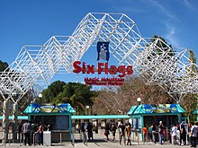
One of the most well-known attractions in the Santa Clarita Valley is the Six Flags Magic Mountain theme park, located just outside the city limits. Six Flags occupies 262 acres of land on the west side of the valley, in unincorporated Valencia. It opened on May 29, 1971, as a development of the Newhall Land and Farming Company[149] and SeaWorld Inc.[150] It was sold to Six Flags in 1979. Six Flags Magic Mountain has 20 roller coasters, the most of any amusement park in the world.[151] The park received an estimated 3.365 million visitors in 2017.[152] It is one of 26 Six Flags properties in North America.[153] The park's property also includes the 25-acre waterpark, Six Flags Hurricane Harbor, which operates from late spring to early fall.[154]
City parks and facilities
[edit]
Since incorporation, the City of Santa Clarita's leadership has placed a priority on offering recreational facilities and programs. The city operates a park system which includes 35 parks scattered throughout the city. Many of the parks have lighted basketball and tennis courts as well as baseball, softball, and soccer fields.[155] The largest city park in Santa Clarita is Central Park in Saugus, on the south side of Bouquet Canyon Road, which includes four outdoor basketball courts; several baseball, softball, and soccer fields; a community garden; disc golf course; cross country course; and the Central Bark dog park.[156]
The George A. Caravalho Sports Complex, located near the intersection of Golden Valley Road and Centre Pointe Parkway in Canyon Country, includes a gymnasium with two indoor, full-sized basketball courts, four pickleball courts, two volleyball courts, two futsal courts, and four racquetball courts.[157] The Sports Complex includes the City of Santa Clarita Activities Center (a.k.a. The Centre) which contains rooms for banquets and meetings. The Sports Complex also includes the Santa Clarita Aquatic Center, which includes three large swimming pools and several water slides; the Trek Bike Park of Santa Clarita covering 7 acres including BMX and mountain biking trails;[158] the Santa Clarita Skate Park; and the Canine Country dog park. Many of the city's recreational programs are held at the Sports Complex.
Over the past several years, the city has cosponsored a summer concert series in cooperation with various local businesses. These concerts, offering a variety of musicians, are offered free of charge and take place on weekends in Central Park. The concert was canceled in 2020 due to the COVID-19 pandemic.[159] The city offers a wide variety of fee-based and free classes and programs in a variety of locations throughout the year.
The city operates two community centers: the Newhall Community Center, adjacent to the Newhall Metrolink station; and the Canyon Country Community Center (CCCC), at the northeast corner of Sierra Highway and Soledad Canyon Road. The Canyon Country Community Center was located at Sierra Highway and Flying Tiger Drive before its relocation in October 2021.[160][161][162]
City-sponsored recreational programs are listed in the quarterly magazine Seasons, which is delivered to all residences within the city limits via mail.[163]
The Santa Clarita Marathon is an annual race through the city's streets and paseos. First run in 1995, it is now considered a qualifying race for the Boston Marathon. Previously held in November, starting in 2022 it was permanently moved to February. Both the 2020 and 2022 marathons were canceled due to the COVID-19 pandemic; there was no 2021 marathon.[164][165][166]
Santa Clarita was picked to host stages in the AMGEN Tour of California for a total of 9 years. It has hosted a total of 14 stages as of 2019.[167]
Surrounded by three mountain ranges, the Santa Clarita area contains numerous hiking trails, in areas such as Agua Dulce Canyon, Central Park, East Walker Ranch, Elsmere Canyon, Golden Valley Ranch, Newhall Pass Open Space, Haskell Canyon Open Space, Quigley Canyon, East Canyon, Fish Canyon, San Francisquito Open Space, Tapia Canyon, Towsley Canyon, and Wildwood Canyon.[168]
County parks
[edit]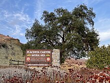
The Los Angeles County Department of Parks and Recreation operates one park within the city of Santa Clarita, and two others within the city's sphere of influence.[54]
William S. Hart Regional Park in Newhall includes the estate of silent film star William S. Hart, known as La Loma de los Vientos (The Hill of the Winds)[169] and has hosted the annual Santa Clarita Cowboy Festival since 1994.[170] The William S. Hart Museum, one of three Natural History Museums of Los Angeles County, is located on the grounds of Hart Park.[171][172] It is the only Los Angeles County park located within the Santa Clarita city limits.
Placerita Canyon State Park is in an unincorporated area east of Newhall, in the western San Gabriel foothills on the southeast side of the Santa Clarita Valley. It is administered by the Los Angeles County Department of Parks and Recreation, in partnership with California State Parks. It features eight hiking trails, equestrian trails, waterfalls, the Oak of the Golden Dream, and the Walker Cabin. Its visitor center, known as Placerita Canyon Nature Center includes exhibits and descriptions of the flora and fauna of the region.[173]
Tesoro Adobe Historic Park was the home of actor Harry Carey, and has been described as "the first tourist attraction in Santa Clarita." It is located in the unincorporated community of Tesoro del Valle, at the northernmost point in Valencia. In June 2005, Montalvo Properties LLC, the developer of Tesoro del Valle, donated the park to Los Angeles County.[174]
Other
[edit]The city is home to an ice rink known as The Cube—Ice and Entertainment Center (formerly Ice Station Valencia).[175] It is used for ice skating and hockey. In 2020, Ice Station Valencia was on the brink of permanent closure due to COVID-19, until the city council unanimously voted to acquire the building for $14.2 million. On February 23, 2021, the city council sold Ice Station to American Sports Entertainment Company and the Los Angeles Kings.[176] The city is currently in the process of renovating The Cube to include two large ice rinks (one NHL-size rink and one Olympic-sized rink) and one small ice rink known as The Pond. The rinks, covered with insulated floors, would double as venues for conventions, business meetings, concerts, birthday parties, and filming.[177] The Cube opened on April 12, 2021, with a ribbon-cutting ceremony.[178] It is the home arena for the UCLA Bruins men's ice hockey team and is located along Smyth Drive in Valencia, across the street from Valencia High School.
MB2 Entertainment,[179] previously known as Mountasia Family Fun Center, is an entertainment and recreation center located in Saugus, along Golden Triangle Road (a frontage road of Soledad Canyon Road) near its intersection with Golden Oak Road. It first opened in August 1995, and currently offers miniature golf, go-karts, bumper boats, laser tag, and video games. On March 15, 2020, it was forced to close due to the COVID-19 pandemic. In September, after nearly six months of closure, the owners sold the center. MB2 Group, which operates go-kart racing tracks, purchased the center in February 2021.[180][181]
Sports
[edit]Santa Clarita does not have any sports teams in the NBA, MLB, NFL, or NHL. The professional teams in Los Angeles and Anaheim (specifically, the Clippers and Lakers of the NBA, the Angels and Dodgers of MLB, the Chargers and Rams of the NFL, and Ducks and Kings of the NHL) are popular among Santa Clarita residents. The college sports teams of The Master's University and College of the Canyons, as well as the sports teams in the valley's seven high schools, have some following among the people of Santa Clarita.
The Santa Clarita Blue Heat is a women's soccer team in the United Women's Soccer league. It was founded as the Ventura County Fusion in 2008 and played in the city of Ventura before relocating to Santa Clarita. Their home games are played at The Master's University.[182] Santa Clarita also hosts FC Santa Clarita (also known as the Santa Clarita Storm) of the United Premier Soccer League, a development league. The team was founded in 2006 as the Lancaster Rattlers before moving to Santa Clarita. Like the Blue Heat, FC Santa Clarita plays its home games at The Master's University.[183]
The Canyons Aquatic Club is a competitive swim team based in Santa Clarita affiliated with USA Swimming. Its home pool is located at College of the Canyons, with practice locations at the Santa Clarita Aquatics Center, Santa Clarita Park, Castaic Aquatic Center, North Oaks Park, and Newhall Park.[184]
The Saugus Speedway, located along Soledad Canyon Road in Saugus, is a 0.33-mile (0.53 km) race track covering 35 acres (14 ha). It first opened in 1939 as Bonelli Stadium. The first stock car racing event on the speedway occurred in 1957. In 1995, the track was permanently closed.[185] The speedway continues to serve as the venue for the Santa Clarita Swap Meet every Sunday.
Central Park contains a 3.1-mile (5.0 km) cross country course used by high school and college athletes to train and race.[156]
The city includes four golf courses: Vista Valencia Golf Course and Valencia Country Club in Valencia, and Sand Canyon Country Club and Friendly Valley Golf Course in Canyon Country.[186] The Oaks Club at Valencia is located in the Westridge area of Stevenson Ranch, adjacent to the city.
The Canyon Country Little League baseball and softball teams play their games on a field along Sierra Highway in unincorporated Canyon Country.[187]
Services
[edit]Law enforcement
[edit]Santa Clarita is a contract city, meaning it does not have its own police department and instead relies on county services. The Los Angeles County Sheriff's Department (LASD) operates the Santa Clarita Valley Sheriff's Station at 26201 Golden Valley Road, just south of the intersection of Golden Valley Road and Centre Pointe Parkway. Prior to its October 2021 relocation, the Santa Clarita Valley Sheriff's Station was located on Magic Mountain Parkway in Valencia.[188][189]
The California Highway Patrol's Newhall office patrols the highways and streets of the Santa Clarita Valley. Despite being referred to as the Newhall office, its headquarters are actually located in unincorporated Valencia, along The Old Road just south of State Route 126. Its service area covers 772 square miles (2,000 km2), including most of northwestern Los Angeles County, containing 204 miles (328 km) of freeways and 296 miles (476 km) of unincorporated roadways.[190]
Water
[edit]
Santa Clarita receives its water from the Santa Clarita Valley Water Agency, also known as SCV Water.[191] The agency was formed on January 1, 2018, through the merger of three agencies: Castaic Lake Water Agency, Newhall County Water District, and the Valencia Water Company. The agency's service area covers about 195 square miles (510 km2) and is home to 273,000 people. It is split into three water divisions—Santa Clarita, Newhall, and Valencia—descendants of the three original agencies. Its headquarters, adjacent to Central Park in Saugus, include a conservatory garden and learning center with over 350 plant species.[192] The SCV Water Agency sources its water from the California Aqueduct, Castaic Lake, alluvial wells, and the Saugus Aquifer.[193] The SCV Water Agency is currently involved in removing hazardous material from the Saugus Aquifer left behind by decades of munitions testing at the Whittaker-Bermite site (see History section above).[194]
The Los Angeles Aqueduct passes through Santa Clarita on its way from the Owens Valley to Granada Hills, Los Angeles. It passes next to, and is visible from, Saugus High School and the Centre Pointe Business Park. However, Santa Clarita does not receive Los Angeles Aqueduct water–all of the aqueduct's water goes to the city of Los Angeles.[195]
Public libraries
[edit]The city operates the Santa Clarita Public Library system, consisting of three libraries: the main office in Valencia, the Old Town Newhall Library in Newhall, and the Jo Anne Darcy Library in Canyon Country. The libraries offer books ranging from preschool to adult reading levels. In addition, each library has a variety of services for students, teachers, and home schoolers, including homework help, mental health, and employment resources, as well as community events. Passport acceptance services are also offered at each library branch. In addition to its three properties, the system includes an eLibrary.[196] The main office in Valencia has a sculpture that says "IMAG NE"; when a person stands between the G and the N the word "IMAGINE" is spelled.
Health services
[edit]
Henry Mayo Newhall Memorial Hospital (commonly referred to as Henry Mayo Hospital), founded in 1975, is a Level II trauma center and hospital. It includes 357 beds, as well as a helipad, an urgent care center, inpatient facilities, a catheterization lab, a breast imaging center, disaster resource center, outpatient surgery center, and cardiac rehabilitation center. It is located in Valencia, along McBean Parkway at its intersections with Avenida Navarre and Orchard Village Road. The complex which contains Henry Mayo Hospital also includes medical institutions not affiliated with the hospital, such as Valencia Perinatal Services, Advanced Pain Management, UCLA Health, and an office of Heritage Sierra Medical Group. Henry Mayo also runs a fitness center along Town Center Drive, about 2 miles (3.2 km) north of the hospital.[197]
Santa Clarita is also served by private health care providers such as Exer Urgent Care, Facey Medical Group, Kaiser Permanente, Concentra Urgent Care, and Providence Health & Services.[198]
As part of Los Angeles County, Santa Clarita is under the jurisdiction of the Los Angeles County Department of Public Health. It does not have its own public health agency.
Electricity and gas
[edit]Santa Clarita does not have its own electricity or natural gas utilities. The city's electricity comes from Southern California Edison,[199] and its natural gas comes from SoCalGas.[200]
Fire
[edit]The city contracts with the Los Angeles County Fire Department for fire protection. The agency has eleven fire stations in the city of Santa Clarita, as well as one station in unincorporated Valencia, two in unincorporated Castaic, one in Val Verde, one in Stevenson Ranch, and one in Agua Dulce.[201]
Post offices
[edit]The United States Postal Service operates four post offices in the city: at Creekside Road and McBean Parkway in central Valencia, on Tournament Road in southern Valencia, at Lyons and Peachland Avenues in Newhall, and at Soledad Canyon Road east of Sierra Highway in Canyon Country. Two post offices are located in the Santa Clarita Valley just outside the city limits, at The Old Road and Towsley Canyon Road in unincorporated Newhall, and on Franklin Parkway in the Valencia Commerce Center.[202] There is also a Contract Postal Unit located in the Saugus Drugs store at Bouquet and Haskell Canyon Roads.[202]
Other
[edit]The California Department of Motor Vehicles has an office in Newhall, at the southwest corner of Lyons Avenue and Newhall Avenue, serving the entire Santa Clarita Valley.[203]
Crime
[edit]Santa Clarita has a relatively low crime rate. The city's violent crime rate is about one-third of the national average and 51% of the California statewide average.[204] In 2020, the home security site Safety ranked Santa Clarita the seventh-safest city in California, specifically mentioning the low property crime rate. Then-mayor Cameron Smyth credited this to the "diligence" of the Santa Clarita Valley Sheriff's Station.[205]
Тем не менее, некоторые из беднейших районов Санта-Клариты борются с преступностью. В жилых комплексах и кондоминиумах вдоль Джейкс-Уэй в Каньон-Кантри (к югу от реки Санта-Клара, к востоку от шоссе Сьерра, к северу от железнодорожной линии Метролинк и к западу от государственного шоссе 14) наблюдается один из самых высоких уровней преступности в городе. [206] Gangs such as Brown Familia[207] and Newhall 13[208] are active in parts of Canyon Country and Newhall.
Другие прошлые инциденты включали перестрелку в 1970 году, известную как инцидент в Ньюхолле , перестрелку на ранчо Стивенсона в 2001 году и стрельбу в средней школе Согуса в 2019 году. [ 49 ]
Экономика
[ редактировать ]Компании, базирующиеся в Санта-Кларите, включают Princess Cruises , Honda Performance Development , Precision Dynamics Corporation , HASA, [ 209 ] и американское подразделение Advanced Bionics. [ 210 ] Sunkist , Mechanix Wear , Remo , condomman.com , Newhall Land and Farming Company и WayForward имеют штаб-квартиры недалеко от города в некорпоративной Валенсии.
Крупнейшие работодатели
[ редактировать ]
Согласно Комплексному годовому финансовому отчету города, за финансовый год, заканчивающийся 30 июня 2020 г., [ 211 ] здесь лучшие работодатели города.
| # | Работодатель | Кол-во сотрудников |
|---|---|---|
| 1 | Волшебная гора Шести Флагов | 3,200 |
| 2 | Принцесса Круизы | 2,092 |
| 3 | Мемориальная больница Генри Мэйо Ньюхолла | 1,917 |
| 4 | Бостон Сайентифик | 1,000 |
| 5 | Магистерский университет | 796 |
| 6 | Уолмарт | 705 |
| 7 | Калифорнийский институт искусств | 700 |
| 8 | Вудворд HRT | 680 |
| 9 | Скорпион Интернет-маркетинг и дизайн | 653 |
| 10 | Продвинутая бионика | 550 |
Промышленные центры
[ редактировать ]Санта-Кларита включает в себя несколько промышленных зон и офисных парков .
Промышленный центр Валенсии — крупнейший бизнес-парк в долине Санта-Кларита площадью 11 000 000 квадратных футов (1 000 000 м²). 2 ) офисных помещений. Он простирается от средней школы Валенсии до развязки I-5/CA-126 и включает в себя штаб-квартиры школьного округа Согус Юнион и The Santa Clarita Valley Signal , офисы Advanced Bionics, Aerospace Dynamics International, Woodward, ATK Audiotek и других предприятий. .
Другие промышленные районы города включают станцию Согус на восточной стороне Железнодорожной авеню; Корпоративный центр Валенсии, на Турни-роуд, к востоку от межштатной автомагистрали 5; Ранчо Нидхэма, на шоссе Сьерра к югу от Ньюхолл-авеню; и Каньон Виста, на Лост-Каньон-роуд к западу от Сэнд-Каньон-роуд. Некорпоративная территория Валенсии к западу от межштатной автомагистрали 5 также содержит несколько бизнес-парков, таких как Торговый центр Валенсии. [ 212 ]
Торгово-коммерческие центры
[ редактировать ]Вестфилд, центр Валенсии
[ редактировать ]
Крупнейшим торговым центром Санта-Клариты является Westfield Valencia Town Center . Этот большой торговый центр, принадлежащий Unibail-Rodamco-Westfield, занимает территорию, ограниченную бульваром Валенсия на юге, бульваром МакБин на западе, бульваром Мэджик-Маунтин на севере и Цитрус-стрит на востоке. [ 213 ] Он включает в себя более 1 000 000 квадратных футов (93 000 м²). 2 ) торговых площадей и содержит 134 магазина и 46 ресторанов. Якорные магазины включают Macy's , JCPenney , H&M , Gold's Gym и Forever 21 ; есть также Regal Edwards . кинотеатр [ 214 ] [ 215 ] Town Center Drive огибает внутреннюю часть торгового центра. города Центр города Вестфилд Валенсия и его окрестности функционируют как один из основных деловых районов : на территории находятся штаб-квартира Princess Cruises , мэрия Санта-Кларита, здание суда Санта-Кларита и медицинский центр долины Санта-Кларита. Шесть из десяти самых высоких зданий города, включая три самых высоких, находятся в центре города или рядом с ним; Два самых высоких здания - это 24305 Town Center Drive (штаб-квартира Princess Cruises) и Hyatt Regency Valencia, оба имеют высоту 72 фута (22 м). [ 69 ] Большинство городских автосалонов расположены к северу от центра города, недалеко от бульвара Мэджик-Маунтин, Криксайд-роуд и Авто-центр-Драйв.
Старый город Ньюхолл
[ редактировать ]Исторический район Старого города Ньюхолл (он же Даунтаун Ньюхолл) — крупный культурный и деловой центр. Здесь есть множество независимых ресторанов, магазинов и театров, а также публичная библиотека. В районах, окружающих Старый город Ньюхолла, проживают преимущественно латиноамериканцы. [ 83 ] и там много мексиканских ресторанов. Театры в Старом городе Ньюхолла включают Canyon Theater Guild, The Main и Laemmle . Фермерский рынок Ньюхолла в Старом городе расположен на территории публичной библиотеки. Другие известные места в этом районе включают Региональный парк Уильяма С. Харта ; Ньюхоллское управление транспортных средств; Начальная школа Ньюхолла (часть школьного округа Ньюхолл ); станция Ньюхолл Метролинк ; Newhall Terrace, Newhall Crossings и калифорнийские жилые комплексы; Историческая площадь ветеранов; Первая пресвитерианская церковь Ньюхолла; Мечеть Центра Единства; Общественный центр Ньюхолла; и исторический железнодорожный вокзал Согуса (перекресток наследия). Официальный сайт Старого города Ньюхолл описывает его как «главный район искусств и развлечений Санта-Клариты». [ 216 ] Место проведения свадеб и мероприятий Hart and Main планируется открыть весной 2022 года. [ 217 ] Некоторые из недавних событий в Старом городе Ньюхолла были описаны как джентрификация . [ 218 ] [ 219 ]
Множество других торговых центров разбросаны по всему городу вдоль основных магистралей. В состав таких торговых центров входят как сетевые магазины , так и предприятия малого бизнеса. Бизнес-парк Centre Pointe расположен недалеко от географического центра города, к югу от Соледад-Каньон-роуд, по обе стороны улицы Голден-Вэлли-роуд. В его состав входят торговые центры Centre Pointe Village и Centre Pointe Marketplace.
СМИ
[ редактировать ]Город Санта-Кларита и прилегающие населенные пункты обслуживаются несколькими местными средствами массовой информации.
Газеты
[ редактировать ]Санта-Кларита обслуживается газетами Los Angeles Daily News и The Santa Clarita Valley Signal . Daily News в основном фокусируется на новостях, спортивных и развлекательных событиях в городе Лос-Анджелесе и прилегающих районах, но также периодически освещает Санта-Клариту. Тираж Daily News в долине Санта-Кларита неизвестен.
Сигнал долины Санта-Кларита
[ редактировать ]Основная ежедневная газета The Santa Clarita Valley Signal была основана в 1919 году. В 2012 году ее тираж в будние дни составил 10 454 экземпляра. [ 220 ] и воскресный тираж 11 598 экземпляров. [ 221 ] До 2018 года газета сосредоточивалась почти исключительно на местных новостях, спорте, развлечениях и репортажах. В октябре 2016 года компания Signal перенесла свою штаб-квартиру с Криксайд-роуд в Валенсии в Даймонд-Плейс недалеко от Сентр-Пуэнт-Паркуэй; [ 222 ] с октября 2021 года штаб-квартира находится на авеню Стэнфорд в промышленном центре Валенсии. [ 223 ]
С 1979 по 2016 год Signal принадлежал компании Morris Multimedia , базирующейся в Саванне, штат Джорджия . В 2016 году Morris Multimedia продала Signal компании Paladin Multi-Media Group. В июне 2018 года Ричард и Крис Бадман приобрели Paladin и начали издавать новый бесплатный воскресный журнал, в котором есть колонка главного редактора Тима Уайта под подписью «Блэк и Уайт». [ 224 ] Согласно статье в Columbia Journalism Review (CJR) от 9 октября 2018 года, новое руководство привело к консервативному сдвигу в редакционной позиции газеты, что побудило группу прогрессистов в долине Санта-Кларита открыть собственное новостное издание. Провозвестник . [ 224 ]
Радио
[ редактировать ]Основной радиостанцией, обслуживающей долину Санта-Кларита, является станция Hometown, или KHTS . KHTS вещает на FM 98.1 и AM 1220. Передатчики KHTS расположены вдоль шоссе Сьерра в некорпоративной северной части страны Каньон, [ 225 ] и его студии находятся в Старом городе Ньюхолле с июня 2015 года. [ 226 ] ХТС был основан как КБЭТ. [ 227 ] в 1984 году и был переименован в КМИС, а затем в ХТС. KHTS — это станция с полным спектром услуг: она освещает местные новости, включая ток-шоу, спорт в средней школе и колледже, а также профессиональный спорт в районе Лос-Анджелеса.
Регион также обслуживается FM-101.5 KZNQ-LP, первой местной FM-радиостанцией Санта-Клариты. Он представляет собой некоммерческий формат музыки в стиле кантри , принадлежащий и управляемый Корпорацией общественного вещания Санта-Кларита, вещающий из Раунд-Маунтин в городе Санта-Кларита с 2015 года. [ 228 ]
Помимо KHTS и KZNQ-LP, Санта-Кларита и окружающие ее районы косвенно обслуживаются рядом крупных FM- и AM-радиостанций Лос-Анджелеса.
Есть также несколько других интернет-радиостанций, которые обслуживают население долины Санта-Кларита. [ 229 ]
Телевидение
[ редактировать ]Все местные программы для Санта-Клариты транслируются на одном общедоступном кабельном телеканале, которым управляет SCVTV, некоммерческая корпорация, освобожденная от налогов 501 (c) (3) . Он доступен клиентам Spectrum Cable по всей долине Санта-Кларита на канале 20, а также клиентам AT&T U-verse в рамках местных программ (канал 99/Санта-Кларита). SCVTV транслирует общественные, образовательные и правительственные программы, включая заседания городского совета Санта-Клариты и Комиссии по планированию, исторические шоу, программы новостей для средних школ и колледжей, ток-шоу, футбольные матчи и другие программы, представляющие местный интерес. SCVTV также управляет сайтом местных новостей scvnews.com. [ 230 ] и исторический сайт scvhistory.com. [ 231 ] scvhistory.com содержит архивы Исторического общества долины Санта-Кларита.
эфирного нет коммерческих станций В долине Санта-Кларита телевидения. Город является частью медиарынка Лос-Анджелеса . Цифровые сигналы со станций Лос-Анджелеса доступны в местных системах кабельного телевидения , DirecTV и Dish Network .
Подкасты
[ редактировать ]Местные студии подкастов, обслуживающие долину Санта-Кларита, включают Podcast SCV. [ 232 ] и Аркей Студиос .
Журналы
[ редактировать ]Журналы, обслуживающие долину Санта-Кларита, включают Seasons (в которых освещаются развлекательные программы, спонсируемые городом), élite , [ 233 ] Магазины Санта-Кларита, [ 234 ] и внутри SCV . [ 235 ]
Транспорт
[ редактировать ]Шоссе
[ редактировать ]- Единственная автомагистраль между штатами в городе — межштатная автомагистраль 5 , которая определяет западную границу города. Межштатная автомагистраль 5 является одной из главных артерий запада Соединенных Штатов и соединяет Санта-Клариту с остальной частью Большого Лос-Анджелеса на юге и Центральной долиной на севере.
- Маршрут штата Калифорния 14 проходит через восточную часть города и соединяет Санта-Клариту с Долины Антилопы городами Палмдейл и Ланкастер . Маршрут 14 сливается с межштатной автомагистралью 5 на большой развязке Ньюхолл-Пасс к югу от города. Эта развязка является основным маршрутом, которым пользуются жители Санта-Кларита, едущие в Лос-Анджелес. Из-за пересеченной местности гор Санта-Сусана и Сан-Габриэль это один из немногих маршрутов (и единственная автострада), соединяющий север округа Лос-Анджелес с остальной частью округа.
- Маршрут штата Калифорния 126 следует по реке Санта-Клара от I-5 в Санта-Кларите до Вентуры , проходя через Пиру , Филлмор и Санта-Паулу . Бульвар ветеранов Санта-Клариты, бывший соединитель Кросс-Вэлли, соединяет шоссе 126 в Валенсии с шоссе 14 на восточной окраине города. Он включает в себя всю улицу Ньюхолл-Ранч-роуд и Золотую долину от Ньюхолл-Ранч-роуд до государственной трассы 14. [ 236 ]
- Шоссе Сьерра проходит через восточную часть города, параллельно и к западу от шоссе 14, обеспечивая альтернативный маршрут к горам Сьерра-Пелона и Долине Антилоп, а также к бассейну Лос-Анджелеса . Хотя это и называется шоссе, на самом деле это наземная улица в районе Санта-Кларита.
Автобусное сообщение
[ редактировать ]Город Санта-Кларита Транзит , ранее известный просто как Санта-Кларита Транзит, обеспечивает обширное автобусное сообщение в пределах долины Санта-Кларита и в/из Северного Голливуда в долине Сан-Фернандо. Город Санта-Кларита Транзит управляется компанией MV Transportation по контракту с городом Санта-Кларита. [ 1 ]
В будние дни компания City of Santa Clarita Transit обслуживает пригородные автобусы от/до станции Юнион-Стейшн в центре Лос-Анджелеса и станции Норт-Голливуд (работает семь дней в неделю как «NoHo Express / 757»), что позволяет пассажирам получить доступ к Metro Los Angeles. скоростному транзитному метро и легкорельсовый транспорт, а также Warner Center , Бербанк , Ван Найс , Сенчури-Сити и Калифорнийский университет в Лос-Анджелесе . Летом город предоставляет ограниченное экспресс-сообщение до пирса Санта-Моники . [ 237 ]
В будние дни, когда идут занятия в школе, City of Santa Clarita Transit предоставляет дополнительные услуги в школьные дни с маршрутами и запланированными остановками, разработанными вокруг различных школ в долине Санта-Кларита.
City of Santa Clarita Transit также предоставляет услугу Dial-A-Ride для пожилых людей и инвалидов. Услуга позволяет осуществлять посадку и высадку по любому адресу в городе Санта-Кларита и в радиусе трех четвертей мили от ближайшей остановки фиксированного маршрутного автобуса в некорпоративных районах. [ 238 ]
Транзит города Санта-Кларита работает по будням с 4:55 до 22:30, по субботам с 6:30 до 21:45 и по воскресеньям с 7:15 до 21:00. Служба работает каждые 10 часов. минут в часы пик до каждых 85 минут в часы внепиковой нагрузки. Обычно автобусы ходят каждые 25–60 минут. [ 239 ]
Железнодорожный
[ редактировать ]
Metrolink обеспечивает пригородное железнодорожное сообщение с долиной Санта-Кларита по линии долины Антилопы , которая проходит между станцией Ланкастер в Ланкастере и станцией Юнион в центре Лос-Анджелеса , откуда можно осуществить пересадку в другие пункты назначения в Южной Калифорнии и за ее пределами. В городе три станции Metrolink: станция Via Princessa в Canyon Country , станция Santa Clarita в Согусе (недалеко от географического центра города) и станция Newhall в Ньюхолле . На всех станциях есть большие парковки, позволяющие пассажирам припарковаться и покататься . Дополнительная заправочная станция Vista Canyon Multi-Modal Center открылась 23 октября 2023 года. [ 240 ] в Стране Каньонов, к востоку от станции Виа Принцесса. [ 241 ] Служба Metrolink работает 7 дней в неделю, с сокращенным обслуживанием по субботам и воскресеньям.
Велосипед и ходьба
[ редактировать ]множество велосипедных По всему городу проложено и пешеходных дорожек. Велосипедисты могут проехать от восточной части города в Стране Каньонов по мощеной дороге, независимой от автомобильного движения, вплоть до Валенсии по тропе реки Санта-Клара . Этот путь следует вдоль реки Санта-Клара и улицы Соледад-Каньон-роуд. На этом маршруте есть множество отправных точек, обеспечивающих доступ к районам, станциям Metrolink и торговым точкам. В Валенсии есть несколько пешеходных мостов, называемых пасео, соединенных с сетью велосипедных дорожек. Пасео удерживают водителей и пешеходов выше и в стороне от автомобильного движения. Планировалось, что районы Валенсии будут включать в себя достаточное количество пешеходных и велосипедных дорожек, которые соединятся с этой общей сетью. Санта-Кларита содержит более 77 миль (124 км) велосипедных маршрутов. В 2007 году Лига американских велосипедистов наградила Санта-Клариту бронзовым статусом сообщества, дружественного к велосипедистам. [ 242 ]
Воздушное путешествие
[ редактировать ]В городе Санта-Кларита нет аэропортов. Ближайшие аэропорты — небольшой аэропорт Агуа Дульсе в Агуа Дульсе и аэропорт Уайтмен в Пакойме . Коммерческие авиалинии летают в аэропорт Боба Хоупа в Бербанке, который находится примерно в 23 милях (37 км), и в международный аэропорт Лос-Анджелеса в Лос-Анджелесе, примерно в 42 милях (68 км) от Санта-Клариты. [ 243 ]
Культура
[ редактировать ]Фильмы
[ редактировать ]Санта-Кларита, наряду с другими предгорными регионами Большого Лос-Анджелеса, известна своими киноранчо . В долине находится несколько киноранчо, в том числе Melody Ranch , Sable Ranch , Rancho Deluxe, Golden Oak Ranch , Blue Cloud Movie Ranch и Veluzat Movie Ranch. Эти киноранчо находятся в зоне студии , в радиусе 30 миль (48 км) от пересечения бульваров Беверли и Ла-Сьенега в западном Лос-Анджелесе . [ 244 ] Киноранчо вносят основной вклад в экономику Санта-Клариты, а долину прозвали «Северным Голливудом». [ 244 ] Фильмы и телешоу, снятые в Санта-Кларите, включают «Джанго освобожденный » , «Морская полиция» , «Франклин и Баш» , «Джейн по замыслу» , «Сделай это или сломай» , «Маппеты» , «Пираты Карибского моря» , «24» и «Олд Йеллер» .
Другие места съемок в долине Санта-Кларита включают Калифорнийский университет искусств, озеро Кастаик, Колледж каньонов, центр города Вестфилд Валенсия, государственный парк Пласерита-Каньон, инновационный парк Южной Калифорнии (офисный парк в Валенсии), кафе Saugus и кафе Halfway House, на окраине Страны Каньонов. [ 245 ] Скалы Васкес , расположенные в Агуа-Дульсе примерно в 10 милях (16 км) к северо-востоку от города, также использовались в качестве места съемок многих фильмов и шоу .
Санта-Кларита была местом действия комедийного шоу ужасов « Диета Санта-Кларита» , которое дебютировало 3 февраля 2017 года. [ 246 ] и был отменен 26 апреля 2019 г. [ 247 ] Шоу вращается вокруг карьеры агентов по недвижимости Джоэла и Шейлы Хаммонд. [ 248 ] Шейла Хаммонд становится нежитью и начинает жаждать человеческой плоти. Пытаясь помочь Шейле во время ее метаморфозы, Джоэл и семья сталкиваются с соседями и культурными нормами . [ 249 ]
Вестерны
[ редактировать ]
Санта-Кларита была домом для многих известных звезд западного кино , в том числе Уильяма С. Харта , Гарри Кэри , Джона Форда и Джина Отри . Деятелей западного кино, телевидения и радио чествуют на Аллее западных звезд, расположенной вдоль Мейн-стрит в Старом городе Ньюхолла. Каждый апрель город Санта-Кларита вводит одного или двух новых лауреатов в Аллею западных звезд. Прогулка была основана в 1981 году; Среди предыдущих лауреатов были Рой Роджерс , Дейл Эванс , Джон Уэйн , Сэм Эллиот , Ричард Фарнсворт и Брюс Дерн . Церемония введения в должность проводится приурочена к Ковбойскому фестивалю Санта-Кларита в парке Уильяма С. Харта. [ 250 ]
Гуманитарный институт Паккарда
[ редактировать ]Гуманитарный институт Паккарда со штаб-квартирой в Лос-Альтосе также имеет кампус в Санта-Кларите . Кампус, открывшийся в 2014 году, расположен в Валенсии, прямо к югу от Колледжа Каньонов. Он включает в себя хранилище фильмов, в котором хранится более 400 000 фильмов от Paramount Pictures , Warner Brothers , Columbia Pictures , 20th Century Fox и Republic Pictures . [ 251 ]
Известные люди
[ редактировать ]Города-побратимы
[ редактировать ]Город является членом Международной ассоциации городов-побратимов .
Пояснительные примечания
[ редактировать ]- ^ Сюда входят только почтовые индексы в пределах города Санта-Кларита. Некоторые почтовые индексы в долине, такие как 91381 (Ранч Стивенсона) и 91384 (Кастаик), имеют приемлемое название «Санта-Кларита», но находятся полностью за пределами города.
- ^ В статье CBS Los Angeles в предыдущей ссылке сообщалось о 66 436 бездомных в округе Лос-Анджелес в январе 2020 года, что составляет 0,66% от общей численности населения округа в 2019 году, составлявшей 10 039 107 человек. Число бездомных в Санта-Кларите в 2020 году составляло 168 человек, что, если разделить его на население города в 2019 году, составляющее 212 979 человек, дает процент бездомных всего 0,078%.
Ссылки
[ редактировать ]- ^ Перейти обратно: а б «Транзит города Санта-Кларита» . Транзит города Санта-Кларита .
- ^ «Города Калифорнии по дате регистрации» . Калифорнийская ассоциация комиссий по формированию местных агентств . Архивировано из оригинала (Word) 3 ноября 2014 года . Проверено 25 августа 2014 г.
- ^ «Городской совет» . Город Санта-Кларита . Проверено 25 сентября 2023 г.
- ^ «Администрация города» . Город Санта-Кларита . Проверено 25 сентября 2023 г.
- ^ Перейти обратно: а б «Городской совет» . Город Санта-Кларита . Проверено 25 сентября 2023 г.
- ^ Перейти обратно: а б «Файлы справочника США за 2019 год» . Бюро переписи населения США . Проверено 1 июля 2020 г.
- ^ Бюро переписи населения США (29 декабря 2022 г.). «Городские территории, отвечающие требованиям переписи населения 2020 года, и окончательные разъяснения критериев» . Федеральный реестр .
- ^ «Санта-Кларита» . Информационная система географических названий . Геологическая служба США , Министерство внутренних дел США . Проверено 5 ноября 2014 г.
- ^ Перейти обратно: а б с «Краткая информация Бюро переписи населения США: город Санта-Кларита, Калифорния» . Бюро переписи населения США . Проверено 28 августа 2021 г.
- ^ «Поиск почтового индекса (тм)» . Почтовая служба США . Проверено 6 декабря 2014 г.
- ^ «Пресс-релиз Министерства финансов Калифорнии» (PDF) . Архивировано из оригинала (PDF) 4 июня 2016 г.
- ^ Кларк, Уильям А.В. (2003). «От моноцентрического к полицейскому: новые городские формы и старые парадигмы». В Бридже, Гэри; Уотсон, Софи (ред.). Спутник города . Издательство Блэквелл. п. 148 . дои : 10.1002/9780470693414.ch13 . ISBN 978-0-470-69341-4 .
- ^ Вей, Дженнифер С.; Форман, Бенджамин (2006). «Демографические изменения в средних городах». В Берубе, А.; Кац, Б.; Ланг, Р.Э. (ред.). Новое определение городской и пригородной Америки: данные переписи населения 2000 года, том 3 . Издательство Брукингского института. п. 26 . ISBN 978-0-8157-0885-8 .
- ^ Ланг, Роберт Э.; ЛеФуржи, Дженнифер Б. (2016). «Этническое разнообразие бумбурбов». В Канторе, Пол; Джадд, Деннис Р. (ред.). Американская городская политика в глобальную эпоху . Рутледж. ISBN 978-1-317-35035-4 .
- ^ Перейти обратно: а б Бостон, Джон; Историческое общество долины Санта-Кларита (2009). Долина Санта-Кларита . Чарльстон, Южная Каролина: Издательство Arcadia. п. 124 . ISBN 978-0-7385-6938-3 .
- ^ Эверетт-Хит, Джон (2014). Краткий словарь географических названий мира (3-е изд.). Издательство Оксфордского университета. ISBN 978-0-1917-5139-4 .
- ^ Ньюхолл, Рут Уолдо (февраль – март 1997 г.). «Как Санта-Кларита получила свое название» . Газета Ньюхолла Старого города . Получено 3 июля 2017 г. - через SCVHistory.com.
- ^ Перейти обратно: а б с Уорден, Леон. «Хронология SCV — хронология исторических событий» . scvhistory.com . Проверено 1 марта 2021 г.
- ^ Хиггинс, Пол (январь – февраль 1996 г.). «Татавиам: первые жители Ньюхолла» . scvhistory.com . Проверено 19 февраля 2021 г.
- ^ "SCVHistory.com | Татавиам Культура" . scvhistory.com . Проверено 24 декабря 2022 г.
- ^ «Миссия Ньюхолл — Сан-Фернандо» . Карты Гугл . Проверено 22 февраля 2021 г.
- ^ Уильямс, Мэри Флойд (июль 1922 г.). «Миссия, президио и пуэбло: заметки о местных учреждениях Калифорнии под властью Испании и Мексики» . Ежеквартальный журнал Калифорнийского исторического общества . 1 (1): 23–35. дои : 10.2307/25613566 . JSTOR 25613566 . Проверено 25 февраля 2021 г.
- ^ Вормсер, Марси (1 сентября 1999 г.). «Потомок Дель Валле следует своим корням» . Сигнал долины Санта-Кларита . Проверено 9 апреля 2007 г.
- ^ Ролз, Джеймс; Орси, Ричард Дж., ред. (1999). Золотой штат: горнодобывающая промышленность и экономическое развитие в Калифорнии в период золотой лихорадки . Полуторасотлетие истории Калифорнии, 2. Беркли и Лос-Анджелес: University of California Press. п. 3. ISBN 0-520-21771-3 .
- ^ «О Генри Мэйо Ньюхолле» . Фонд Генри Мэйо Ньюхолла. 2000 . Проверено 20 апреля 2007 г.
- ^ «Наземные почтовые станции Баттерфилда в Калифорнии от миссии Сан-Фернандо до Поузи-Крик» (PDF) . scvhistory.com . Проверено 26 февраля 2021 г.
- ^ "CHL # 1006 Проход дилижанса Била" . Исторические достопримечательности Калифорнии . Проверено 16 января 2021 г.
- ^ Уорден, Леон (24 февраля 2004 г.). «Ньюхолл под любым другим именем… это Илайон» . scvhistory.com . Проверено 6 июня 2021 г.
- ^ Перейти обратно: а б Капейс, Нэнси (1999). Энциклопедия Калифорнии . ООО «Североамериканский книжный дист». Страница 428. ISBN 9780403093182 .
- ^ Альваренга, Эмили (26 мая 2019 г.). «История названий: издание SCV» . Сигнал долины Санта-Кларита . Проверено 20 марта 2021 г.
- ^ «Станция Ланг 1936» . scvhistory.com . Проверено 5 января 2021 г.
- ^ Уорден, Леон. «Друзья Ментривилля: первый город нефтяного бума в Калифорнии» . scvhistory.com . Друзья Ментривилля . Проверено 5 января 2020 г.
- ^ Гонсалес, Кристина (12 декабря 2020 г.). «Оригинальное кафе Saugus: старейший ресторан Лос-Анджелеса, переживающий недавний запрет на обеды на открытом воздухе» . FOX11 Лос-Анджелес . Проверено 18 января 2021 г.
- ^ «DTSC использует бактерии для избавления Уиттакера-Бермита от перхлората» . scvhistory.com . Проверено 19 февраля 2021 г.
- ^ Уорден, Леон. «Нескважинная вода: проблема перхлората» . scvhistory.com . Проверено 19 февраля 2021 г.
- ^ Смит, Перри (27 февраля 2024 г.). «Новый застройщик, новые планы» . Сигнал долины Санта-Кларита . Проверено 28 февраля 2024 г.
- ^ Поллак, Алан (13 марта 2014 г.). «Катастрофа на плотине Святого Франциска: расширенный график» . scvhistory.com . Проверено 21 февраля 2021 г.
- ^ Стэнселл, Энн. «Список жертв плотины Святого Франциска» . scvhistory.com . Проверено 21 февраля 2021 г.
- ^ «SCVHistory.com SW3602 | Авиакатастрофы | Авиакатастрофа 1936 года в Райс-Каньоне: поиск пострадавших» . scvhistory.com . Проверено 13 апреля 2020 г.
- ^ «Округ начальной школы Союза Салфер-Спрингс до CA-14» . Округ начальной школы Союза Салфер-Спрингс до CA-14 .
- ^ «Калифорнийский ККК проводит митинг, поджигая фальшивый крест в каньоне Соледад» . scvhistory.com . Проверено 8 января 2021 г.
- ^ «Инцидент в Ньюхолле» . scvhistory.com . Проверено 22 февраля 2021 г.
- ^ «Непосредственная причина: пилот вспоминает трагедию из фильма «Сумеречная зона»» . scvhistory.com . 23 июля 2013 года . Проверено 24 февраля 2021 г.
- ^ Перейти обратно: а б с д Рейнольдс, Джерри. «История долины Санта-Кларита» . СКВТВ . Проверено 22 июля 2023 г.
- ^ Пиплс, Стивен К. (20 марта 2019 г.). «Cemex теряет федеральную апелляцию; мегарудник в каньоне Соледад фактически мертв» . Новости СКВ . Проверено 19 марта 2021 г.
- ^ Перейти обратно: а б «Хронология событий после землетрясения 17 января 1994 года» . scvhistory.com . Проверено 16 января 2021 г.
- ^ «Оценка ущерба долине Санта-Кларита» . Город Санта-Кларита. Декабрь 1994 года . Проверено 16 июня 2021 г.
- ^ «Журнал MONEY: Лучшие места для жизни 2006: 100 лучших мест 1–25» . деньги.cnn.com . Архивировано из оригинала 27 октября 2007 года.
- ^ Перейти обратно: а б Фрай, Ханна; и др. (14 ноября 2019 г.). «Стрельба в Санта-Кларите: убиты двое подростков; нападение произошло в день рождения подозреваемого, - говорят официальные лица» . Лос-Анджелес Таймс . Архивировано из оригинала 14 ноября 2019 года . Проверено 14 ноября 2019 г.
- ^ Холт, Джим (14 ноября 2019 г.). «2 ученика убиты, 4 ранены в результате стрельбы в средней школе Согуса» . scvhistory.com . Проверено 20 февраля 2021 г.
- ^ Уорден, Леон (20 августа 2011 г.). «Пара частных микрорайонов открылась в Валенсии» . SCVNews.com . Проверено 23 марта 2021 г.
- ^ Перейти обратно: а б «Новые жилые комплексы в Санта-Кларите» . Грегори Риэл Эстейт Групп. 17 августа 2021 г. . Проверено 16 октября 2021 г.
- ^ Коллинз, Джефф (14 января 2020 г.). «Новые дома на горизонте после продажи участков в Валенсии за 135 миллионов долларов» . Ежедневные новости . Проверено 12 марта 2021 г.
- ^ Перейти обратно: а б с «Завершенные аннексии» . Город Санта-Кларита . Проверено 25 сентября 2023 г.
- ^ «Интерактивные карты Анджелеса NF» . Лесная служба США . Проверено 26 марта 2021 г.
- ^ «Санта-Кларита, Калифорния» . Lat-Long.com . Проверено 26 марта 2021 г.
- ^ «Карта аэропорта Согус-Ньюхолл, 1930 год» . Историческое общество долины Санта-Кларита . Проверено 26 марта 2021 г.
- ^ «Поиск высот по всему миру / Топографическая карта / Карта высот» . возвышение.maplogs.com . Проверено 3 апреля 2021 г.
- ^ «Карты Google» . Карты Гугл .
- ^ «Интерактивная карта классификации климата Кеппена США» . plantmaps.com . Проверено 5 марта 2021 г.
- ^ «СитиНьюс» . Торонто.citynews.ca .
- ^ «Карта зон устойчивости растений Министерства сельского хозяйства США на 2023 год» . Министерство сельского хозяйства США . Проверено 28 ноября 2023 г.
- ^ «34 ° 25' с.ш., 118 ° 31' з.д. — восход, закат и длина светового дня, декабрь 2023 г.» . timeanddate.com .
- ^ Измеренные температуры исключают периоды с июня по декабрь 2016 г. и с июня по декабрь 2021 г. Осадки измерялись в 1997–2014 гг. на Стивенсон-Ранч.
- ^ КСМАЦИС
- ^ Дуг Смит; Бен Уэлч (18 декабря 2018 г.). «Миллиону зданий в Калифорнии угрожает опасность лесных пожаров. Для их защиты необходимы «чрезвычайные меры» . Лос-Анджелес Таймс . Проверено 30 мая 2022 г.
- ^ Беннетт, Жаклин (5 ноября 2021 г.). «Что такое ветры Санта-Ана и вызывают ли они лесные пожары?» . Новости спектра . Проверено 30 мая 2022 г.
- ^ «Атлас глобальной охраны природы» . Maps.tnc.org . Архивировано из оригинала 5 марта 2012 года . Проверено 9 апреля 2021 г.
- ^ Перейти обратно: а б «Самые высокие здания Санта-Клариты» . Эмпорис. Архивировано из оригинала 13 мая 2021 года . Проверено 3 апреля 2021 г.
- ^ «Поиск почтового индекса™» . USPS . Проверено 11 июля 2021 г.
- ^ «Изучите данные переписи» .
- ^ Город Санта-Кларита (май 2019 г.). «Анализ препятствий на пути справедливого выбора жилья (AI)» .
- ^ «Расовый / этнический состав по городам и некорпоративным сообществам, 2010 г., округ Лос-Анджелес, Калифорния» .
- ^ https://www2.census.gov/library/publications/2002/dec/phc-1-6.pdf . [ только URL-адрес PDF ]
- ^ https://www2.census.gov/library/publications/decennial/1990/cp-2/cp-2-6-1.pdf . [ только URL-адрес PDF ]
- ^ «4. Белые и черные» (PDF) . Архивировано из оригинала (PDF) 15 марта 2023 года . Проверено 18 июня 2024 г.
- ^ «4. Белые и черные» (PDF) . Архивировано из оригинала (PDF) 15 марта 2023 года . Проверено 18 июня 2024 г.
- ^ «Латиноамериканец или латиноамериканец, а не латиноамериканец или латиноамериканец по расе» . Бюро переписи населения США . Проверено 19 сентября 2021 г.
- ^ «Санта-Кларита заняла 20-е место среди самых быстрорастущих городов Америки» . Станция Родной город. 17 октября 2019 года . Проверено 8 января 2021 г.
- ^ «Краткие факты» . Бюро переписи населения США . Проверено 22 августа 2022 г.
- ^ «Самые густонаселенные города округа Лос-Анджелес, Калифорния» . Лос-Анджелесский альманах . Проверено 16 января 2021 г.
- ^ Перейти обратно: а б «Избранные экономические характеристики» . Бюро переписи населения США . Проверено 8 января 2021 г.
- ^ Перейти обратно: а б «Расовая точечная карта» . Центр государственной службы Уэлдона Купера . Проверено 19 февраля 2021 г.
- ^ «Карта доходов домохозяйств по районам в Санта-Кларите» . статистический атлас.com . Проверено 11 июня 2021 г.
- ^ «Высшая школа Валенсии» . Национальный центр статистики образования . Проверено 20 мая 2021 г.
- ^ «Высшая школа Золотой долины» . Национальный центр статистики образования . Проверено 20 мая 2021 г.
- ^ «Статистические районы мегаполисов и микрополитенов США и Пуэрто-Рико» (PDF) . Бюро переписи населения США. Март 2020 года . Проверено 7 марта 2021 г.
- ^ «Объединенные статистические территории США и Пуэрто-Рико» (PDF) . Бюро переписи населения США. Март 2020 года . Проверено 7 марта 2021 г.
- ^ Калифорния: 2000 г. - Краткие характеристики населения и жилья (PDF) . Министерство торговли США. Ноябрь 2002 года . Проверено 18 июня 2024 г.
- ^ «Город Санта-Кларита: анализ препятствий на пути справедливого выбора жилья (AI)» (PDF) . Город Санта-Кларита . Проверено 18 июня 2024 г.
- ^ «латиноамериканец или латиноамериканец, а не латиноамериканец или латиноамериканец по расе» . Бюро переписи населения США . Бюро переписи населения США . Проверено 18 июня 2024 г.
- ^ "Раса" . Бюро переписи населения США . Проверено 19 сентября 2021 г.
- ^ «Латиноамериканец или латиноамериканец, а не латиноамериканец или латиноамериканец по расе» . Бюро переписи населения США . Проверено 19 сентября 2021 г.
- ^ «Статус занятости» . Бюро переписи населения США . Проверено 19 сентября 2021 г.
- ^ «Домашние ценности Санта-Клариты» . Зиллоу . Проверено 2 декабря 2023 г.
- ^ Изменение границ Дэйва (граница максимально соответствует реке Санта-Клара)
- ^ «Отдельные характеристики коренного и иностранного населения» . Бюро переписи населения США . Проверено 16 января 2021 г.
- ^ «Образовательный уровень» . Бюро переписи населения США . Проверено 16 января 2021 г.
- ^ «Язык, на котором говорят дома» . Бюро переписи населения США . Проверено 10 марта 2021 г.
- ^ «Интерактивный поиск населения по переписи населения 2010 года: Калифорния — город Санта-Кларита» . Бюро переписи населения США. Архивировано из оригинала 15 июля 2014 года . Проверено 12 июля 2014 г.
- ^ Перейти обратно: а б «Краткая информация о городе Санта-Кларита, Калифорния, от Бюро переписи населения США» . Проверено 15 мая 2016 г.
- ^ Перейти обратно: а б «Религия в Санта-Кларите, Калифорния» . Лучшие места . Проверено 26 февраля 2021 г.
- ^ «Церкви в Санта-Кларите, Калифорния» . Поиск церкви . Проверено 31 августа 2023 г.
- ^ «Хабад СКВ» . Проверено 31 августа 2023 г.
- ^ «Храм Бет Ами» . Проверено 31 августа 2023 г.
- ^ «Конгрегация Бет Шалом Санта-Кларита» . Проверено 31 августа 2023 г.
- ^ «Исламский центр долины Санта-Кларита» . Проверено 31 августа 2023 г.
- ^ «Центр Единства Санта-Клариты» . Проверено 31 августа 2023 г.
- ^ «Центр Аль-Уммы в Санта-Кларите» . Проверено 31 августа 2023 г.
- ^ «Подсчет бездомных в 2020 году показывает снижение числа бездомных в Санта-Кларите» . Город Санта-Кларита. 30 июля 2020 года. Архивировано из оригинала 25 мая 2021 года . Проверено 25 мая 2021 г.
- ^ «Мост к дому» . Мост к Дому . Проверено 25 мая 2021 г.
- ^ «Новый федеральный отчет показывает масштабы кризиса бездомных в Калифорнии: до пандемии более 160 тысяч бездомных» . ЦБСЛА. 19 марта 2021 г. . Проверено 30 мая 2021 г.
- ^ «Данные выборов» (PDF) . выборы.cdn.sos.ca.gov . Проверено 30 июля 2020 г.
- ^ «Данные выборов» (PDF) . lavote.net . Проверено 21 декабря 2020 г.
- ^ «Данные выборов» (PDF) . выборы.cdn.sos.ca.gov . Проверено 30 июля 2020 г.
- ^ «Данные выборов» (PDF) . выборы.cdn.sos.ca.gov . Проверено 30 июля 2020 г.
- ^ «Данные выборов» (PDF) . выборы.cdn.sos.ca.gov . Проверено 30 июля 2020 г.
- ^ «Данные выборов» (PDF) . выборы.cdn.sos.ca.gov . Проверено 30 июля 2020 г.
- ^ «Данные выборов» (PDF) . выборы.cdn.sos.ca.gov . Проверено 30 июля 2020 г.
- ^ «Данные выборов» (PDF) . выборы.cdn.sos.ca.gov . Проверено 30 июля 2020 г.
- ^ «Данные выборов» (PDF) . выборы.cdn.sos.ca.gov . Проверено 30 июля 2020 г.
- ^ «Заявление о голосовании» . 1988.
- ^ «Выборы в городской совет» . Голосуйте за Санта-Клариту . Проверено 24 апреля 2020 г.
- ^ «Члены совета Санта-Клариты обсуждают окружные выборы в свете иска Санта-Моники» . Сигнал долины Санта-Кларита . 29 июля 2020 г. . Проверено 18 марта 2021 г.
- ^ «Подробный годовой финансовый отчет города Санта-Кларита» . 30 июня 2020 г. Проверено 25 сентября 2023 г.
- ^ «Отделы» . Город Санта-Кларита . Проверено 25 сентября 2023 г.
- ^ «Члены городского совета Санта-Клариты, с 1987 г. по настоящее время» . scvhistory.com . Проверено 8 января 2021 г.
- ^ Отбывал два срока подряд.
- ^ Перейти обратно: а б Стюарт, Рэйчел (9 декабря 2020 г.). «Миранда приведена к присяге в качестве нового мэра Санта-Клариты; Гиббс заменяет Келлара в совете» . scvnews.com . Проверено 8 января 2021 г.
- ^ «Карта Пятого надзорного округа» (PDF) . Наблюдательный совет округа Лос-Анджелес . Округ Лос-Анджелес . Проверено 26 ноября 2020 г.
- ^ «Новые избирательные округа Калифорнии» . Лос-Анджелес Таймс . 21 декабря 2021 . Проверено 17 мая 2022 г.
- ^ «Сенат штата Калифорния 2022» . Перераспределение округов Дэйва . Проверено 30 мая 2022 г.
- ^ «Государственный дом CA 2022» . Перераспределение округов Дэйва . Проверено 30 мая 2022 г.
- ^ «Государственный дом CA 2022» . Перераспределение округов Дэйва . Проверено 30 мая 2022 г.
- ^ Перейти обратно: а б с "У. С. Харт Юнион Хай СД" . Поиск школьного сайта . Проверено 23 марта 2021 г.
- ^ Браун, Майкл (сентябрь 2020 г.). «Средние школы округа Харт вошли в число 12% лучших школ страны» . Станция Родной город . Проверено 8 января 2021 г.
- ^ «Средняя школа Боумана» . www.bowmanhighschool.org .
- ^ «Обучающаяся почтовая академия» . www.learningpostacademy.org .
- ^ «Чартерная школа SCVi | Свобода мысли. Вдохновение на лидерство» . SCVi, школа-основатель iLEAD .
- ^ Загородный центр OFL Canyon
OFL Санта-Кларита (Валенсия) Центр - ^ «Школа для взрослых Золотой Дуб» . www.goldenoakadultschool.com .
- ^ «Лучшие частные школы Санта-Клариты 2021 года» . Ниша . Проверено 9 марта 2021 г.
- ^ «Интервью с Томом Лоусоном, деканом школы искусств CalArts, январь 2007 г.» . Архивировано из оригинала 10 мая 2013 года . Проверено 23 декабря 2020 г.
- ^ «ПРЕЗИДЕНТ (ВРЕМЕННО) АБНЕР ЧОУ» . Магистерский университет . Проверено 13 марта 2021 г.
- ^ Падилья, Стив (5 ноября 1990 г.). «Удивительный рост: сонный баптистский колледж набирает обороты под руководством нового руководителя» . Лос-Анджелес Таймс . Проверено 20 февраля 2021 г.
- ^ «Доктор Джон Стед назначен временным президентом TMU» . Магистерский университет. 16 апреля 2019 года . Проверено 20 февраля 2021 г.
- ^ "Дом" . Колледж Каньонов . Проверено 30 мая 2022 г.
- ^ «Чартерный колледж в стране Каньонов» . Чартерный колледж. 16 марта 2012 года . Проверено 30 мая 2021 г.
- ^ «Ньюхоллская земельная и фермерская компания» . Энциклопедия истории компаний . Группа Гейл . Проверено 8 января 2021 г.
- ^ «Первоначальное строительство Волшебной горы» . scvhistory.com . Проверено 8 января 2021 г.
- ^ Макдональд, Брэди (2 мая 2012 г.). «Six Flags Magic Mountain вернет себе титул американских горок» . Лос-Анджелес Таймс . Проверено 8 января 2021 г.
- ^ «Отчет о посещаемости глобальных достопримечательностей TEA/AECOM 2017» (PDF) . Ассоциация тематических развлечений . 21 мая 2018 года . Проверено 21 мая 2018 г.
- ^ Фейс, Скотт (20 июня 2020 г.). «Six Flags вновь открывается с усиленными протоколами безопасности» . ИААПА . Проверено 13 июля 2020 г.
- ^ «Шесть флагов Ураганная гавань Лос-Анджелес» . Тематические парки Южной Калифорнии . Проверено 28 апреля 2022 г.
- ^ «Городские парки и объекты» . Город Санта-Кларита . Проверено 25 сентября 2023 г.
- ^ Перейти обратно: а б «Центральный парк» . Поход в Санта-Клариту . Проверено 16 января 2021 г.
- ^ «Гимназия спортивного комплекса Джорджа А. Каравальо Санта-Кларита» . Город Санта-Кларита . Проверено 25 сентября 2023 г.
- ^ Мурга, Тэмми (11 сентября 2020 г.). «Город открывает долгожданный велопарк» . Сигнал долины Санта-Кларита . Проверено 5 апреля 2021 г.
- ^ «Концерты в парке» . Город Санта-Кларита . Проверено 25 сентября 2023 г.
- ^ «Общественный центр Ньюхолла» . Город Санта-Кларита . Проверено 25 сентября 2023 г.
- ^ «Общественный центр страны Каньон» . Город Санта-Кларита . Проверено 25 сентября 2023 г.
- ^ «Публика приглашена на торжественное открытие общественного центра Canyon Country» . Город Санта-Кларита. 29 октября 2021 г. . Проверено 6 ноября 2021 г. - через YouTube.
- ^ «Времена года» . Город Санта-Кларита . Проверено 25 сентября 2023 г.
- ^ Страттон, Джонатан (1 ноября 2019 г.). «Марафон Санта-Кларита закроет улицы на выходных» . Станция Родной город . Проверено 25 февраля 2021 г.
- ^ Лунетта, Калеб (10 января 2022 г.). «Марафон Санта-Кларита 2022 года отменен» . Сигнал долины Санта-Кларита . Проверено 19 февраля 2022 г.
- ^ «Марафон Санта-Кларита 2022 года отменен» . Сигнал долины Санта-Кларита. 3 августа 2020 г. Проверено 19 февраля 2022 г.
- ^ «AMGEN Tour of California (этап Санта-Кларита)» . AMGEN Тур по Калифорнии . Проверено 25 февраля 2021 г.
- ^ «Куда идти» . Hiksantaclarita.com . Проверено 3 октября 2016 г.
- ^ «Лома де лос Вьентос» . Друзья Харт Парка . Проверено 21 февраля 2021 г.
- ^ Мадрен, Челси (26 марта 2016 г.). «23-й ежегодный ковбойский фестиваль в Санта-Кларите приедет в Ньюхолл, Калифорния — AXS» . M.axs.com . Проверено 26 апреля 2017 г.
- ^ «Региональный парк Уильяма С. Харта» . Департамент парков и отдыха округа Лос-Анджелес . Проверено 8 января 2021 г.
- ^ "ДОМАШНЯЯ СТРАНИЦА ХАРТА" . Музей Уильяма С. Харта . Проверено 17 января 2021 г.
- ^ «Государственный парк Пласерита-Каньон» . Департамент парков и отдыха округа Лос-Анджелес . Проверено 13 января 2021 г.
- ^ «Исторический парк Тесоро Adobe» . Департамент парков и отдыха округа Лос-Анджелес . Проверено 14 января 2021 г.
- ^ Мурга, Тэмми (5 марта 2021 г.). « Куб»: Город раскрывает новое название катка» . Сигнал долины Санта-Кларита . Проверено 17 марта 2021 г.
- ^ Мурга, Тэмми (23 февраля 2021 г.). «Городской совет одобрил LA Kings в качестве партнера в качестве новых операторов ледового катка» . Сигнал долины Санта-Кларита . Проверено 24 февраля 2021 г.
- ^ Миранда, Билл (12 марта 2021 г.). «Готовы приветствовать сообщество в The Cube» . Сигнал долины Санта-Кларита . Проверено 17 марта 2021 г.
- ^ Миллер, Девон (16 марта 2021 г.). «Установлена дата открытия ледового развлекательного центра «Куб»» . Новости Вэлли Пост . Проверено 17 марта 2021 г.
- ^ «MB2 Entertainment, бывший семейный развлекательный центр Mountasia в Санта-Кларите, объявляет о торжественном открытии осенью» . Станция Родной город. 30 сентября 2021 г. . Проверено 23 октября 2021 г.
- ^ Браун, Майкл (8 сентября 2020 г.). «Санта-Кларита-Маунтасия вынуждена продать развлекательный центр из-за закрытия на шесть месяцев» . Станция Родной город . Проверено 25 марта 2021 г.
- ^ Альваренга, Эмили (23 февраля 2021 г.). «MB2 покупает Mountasia» . Сигнал долины Санта-Кларита . Проверено 25 марта 2021 г.
- ^ «Стадион» . Санта-Кларита Блю Хит . Проверено 16 января 2021 г.
- ^ «Стадион» . Санта-Кларита Шторм . Проверено 16 января 2021 г.
- ^ «Локации» . Водный клуб «Каньонс» . Проверено 25 июня 2021 г.
- ^ «Согус Спидвей — NASCAR» . Современные руины. 3 октября 2012 года . Проверено 25 мая 2021 г.
- ^ «Окрестности Санта-Кларита» . santaclarita.com . Проверено 24 марта 2021 г.
- ^ "Дом" . Маленькая лига страны Каньона . Проверено 17 января 2021 г.
- ^ «Новый участок шерифа долины Санта-Кларита округа Лос-Анджелес скоро откроется на улице Голден-Вэлли-роуд» . Лос-Анджелес Дейли Ньюс. 18 октября 2021 г. Проверено 28 мая 2022 г.
- ^ «Участок шерифа долины Санта-Кларита» . Департамент шерифа округа Лос-Анджелес . Проверено 27 февраля 2021 г.
- ^ «(540) Ньюхолл» . Калифорнийский дорожный патруль . Проверено 27 февраля 2021 г.
- ^ «SCV Water — ваше агентство водоснабжения долины Санта-Кларита» . СКВ Вода . Проверено 27 февраля 2021 г.
- ^ «Демонстрационные сады» . СКВ Вода . Проверено 27 февраля 2021 г.
- ^ «Местный источник воды» . СКВ Вода . Проверено 27 февраля 2021 г.
- ^ «ПРОЕКТ: Удаление опасных веществ из водоносного горизонта формации Саугус» . Водное агентство SCV . Проверено 17 марта 2021 г.
- ^ Тринидад, Элсон (4 ноября 2013 г.). «Самостоятельная экскурсия по акведуку Лос-Анджелеса» . КСЭТ . Проверено 25 мая 2021 г.
- ^ «Публичная библиотека Санта-Клариты» . Город Санта-Кларита . Проверено 12 января 2021 г.
- ^ «Генри Мэйо: Фитнес и здоровье» . Мемориальный госпиталь Генри Мэйо Ньюхолл . Проверено 5 апреля 2021 г.
- ^ «Медицинские центры» . Карты Гугл . Проверено 11 июля 2021 г.
- ^ «Территория нашего обслуживания» . Южная Калифорния Эдисон . Проверено 27 февраля 2021 г.
- ^ "Профиль компании" . SoCalGas . Проверено 27 февраля 2021 г.
- ^ «Пожарные станции округа Лос-Анджелес» . Карты Гугл . Проверено 22 февраля 2021 г.
- ^ Перейти обратно: а б «Найти местоположения USPS» . Почтовая служба США . Проверено 28 мая 2022 г.
- ^ «Ньюхолл — Калифорния DMV» . Калифорнийский департамент автотранспорта . Проверено 16 января 2021 г.
- ^ «Отчет о преступности в Санта-Кларите, Калифорния, 2023 год» . ГлавнаяЗакуски . Проверено 13 июля 2023 г.
- ^ Миллер, Девон (25 сентября 2020 г.). «Санта-Кларита названа седьмым самым безопасным городом Калифорнии» . Станция Родной город . Проверено 7 января 2021 г.
- ^ «Путь Джейка видит более высокий уровень преступности» . Лос-Анджелес Дейли Ньюс . 12 августа 2007 года . Проверено 15 февраля 2021 г.
- ^ Холт, Джим; Дэйв; Остин (26 января 2018 г.). «Пять человек арестованы в ходе зачистки района, на который напали банды» . Сигнал долины Санта-Кларита . Проверено 15 февраля 2021 г.
- ^ Дэйв, Остин (21 сентября 2017 г.). «Трое арестованы в ходе бандитской зачистки Ньюхолла 13» . Сигнал долины Санта-Кларита . Проверено 15 февраля 2021 г.
- ^ «Бассейн HASA — обеспечение безопасности и чистоты вашей воды с 1964 года» . ХАСА . Проверено 29 августа 2021 г.
- ^ «Глобальные офисы» . Продвинутая бионика . Проверено 15 апреля 2021 г.
- ^ «Подробный годовой финансовый отчет города Санта-Кларита, Калифорния» . Город Санта-Кларита. 28 декабря 2020 г. Проверено 25 сентября 2023 г.
- ^ «Бизнес-парки SCV» . Корпорация экономического развития долины Санта-Кларита . Проверено 9 октября 2021 г.
- ^ «Проект объединения патио» . Вестфилд . Проверено 25 февраля 2021 г.
- ^ «Магазины» . Вестфилд, центр Валенсии . Проверено 8 января 2020 г.
- ^ «Рестораны» . Вестфилд, центр Валенсии . Проверено 8 января 2020 г.
- ^ «Старый город Ньюхолл» . Старый город Ньюхолл . Проверено 6 марта 2021 г.
- ^ «Знакомьтесь с торговцами из Харта и Мейна» . Журнал Санта-Кларита. 1 мая 2021 г. . Проверено 9 июня 2021 г.
- ^ «Центр Ньюхолла» . Группа Галлатин . Проверено 13 марта 2021 г.
- ^ «Ваши налоги на работе и отдыхе» . Внутри СКВ. Апрель 2016 года . Проверено 13 марта 2021 г.
- ^ Тайтл. «Подтвержденное аудиторское обращение» . Проверено 15 мая 2016 г.
- ^ Тайтл. «Подтвержденное аудиторское обращение» . Проверенныйaudit.com . Проверено 2 августа 2012 г.
- ^ Кенни, Кевин (7 октября 2016 г.). «Прощай, Криксайд-Роуд – здравствуй Даймонд-Плейс. Сигнал пакует чемоданы и переезжает через город» . Сигнал долины Санта-Кларита . Проверено 4 апреля 2021 г.
- ^ "Дом" . signalscv.com .
- ^ Перейти обратно: а б Даррач, Аманда (9 октября 2018 г.). «Обе стороны сейчас: когда газета калифорнийского города начинает беспокоить новых владельцев, критики начинают свою собственную» . Обзор журналистики Колумбии (CJR) . Проверено 9 октября 2018 г.
- ^ «ХТС-АМ 1220 кГц — Каньон-Кантри, Калифорния» . Радиолокатор . Проверено 8 января 2020 г.
- ^ Бойер, Джессика (30 июня 2015 г.). «ХТС АМ-1220 переезжает из Страны Каньонов в Старый город Ньюхолл» . Станция Родной город . Проверено 8 января 2021 г.
- ^ «Справочник радиостанций США» (PDF) . Ежегодник радиовещания и кабельного телевидения . Нью-Провиденс, Нью-Джерси: Р.Р. Боукер. 1994. с. Б-32 . Проверено 24 июня 2018 г.
- ^ «Q-101.5/KZNQ Горячий кантри-хит» . Q-101.5 / KZNQ Радио «Горячий кантри-хит» .
- ^ «Радиостанции Санта-Кларита, Калифорния» . Стрима . Проверено 26 февраля 2021 г.
- ^ «Новости долины Санта-Кларита для Ньюхолла, Согуса, Валенсии, Каньон-Кантри, Кастаика, Стивенсон-Ранч, Агуа-Дульсе, Актона» . SCVNews.com . Проверено 16 марта 2022 г.
- ^ «Архив истории долины Санта-Кларита | Научная библиотека | История SCV в картинках» . SCVHistory.com . Проверено 16 марта 2022 г.
- ^ «Подкаст SCV | Студия подкастов в Санта-Кларите» . www.podcastscv.com .
- ^ «Элитный журнал Interactive Media Санта-Клариты» . Элитный журнал .
- ^ Журнал Санта-Кларита ,
- ^ «Журнал Santa Clarita California - ежемесячный глянцевый журнал Inside SCV» . Внутри журнала SCV .
- ^ Харбин, Хизер (27 января 2016 г.). «Соединитель Кросс-Вэлли будет переименован в честь военнослужащих США в Санта-Кларите» . Станция Родной город . Проверено 11 февраля 2021 г.
- ^ [http://santaclaritatransit.com/routes-schedules/commuter-express/noho-express/ "NoHo Express"]. Транзит города Санта-Кларита . Проверено 21 июня 2019 г.
- ^ «Услуги вызова и доступа» . Транзит города Санта-Кларита . Проверено 7 января 2021 г.
- ^ «Маршруты и расписания» . Транзит города Санта-Кларита . Проверено 7 января 2021 г.
- ^ Стриплин, Кен (2 октября 2023 г.). «Открытие каньона Виста» . СКВТВ . Проверено 3 октября 2023 г.
- ^ «Проект станции метро Vista Canyon» . CEQAnet. 23 октября 2018 года . Проверено 7 января 2020 г.
- ^ Маклин, Марша (30 сентября 2007 г.). «Санта-Кларита названа сообществом, дружественным к велосипедистам» . Сигнал . Архивировано из оригинала 19 июля 2011 года . Проверено 15 апреля 2011 г.
- ^ Карты Google, показывающие расстояние от Центрального парка до аэропорта Бербанка.
Карты Google с указанием расстояния от Центрального парка до Лос-Анджелеса - ^ Перейти обратно: а б Веррье, Ришар (24 января 2012 г.). «Киноранчо Санта-Кларита загоняет Тарантино и других кинематографистов » Лос-Анджелес Таймс . Получено 9 , января
- ^ «Задняя часть Голливуда» . Путеводитель по Санта-Кларите . Проверено 27 февраля 2021 г.
- ^ Вагмайстер, Элизабет (18 марта 2016 г.). «Дрю Бэрримор и Тимоти Олифант сыграют главные роли в комедийном сериале Netflix «Диета Санта-Кларита» » . Разнообразие .
- ^ Андреева, Нелли (8 мая 2018 г.). Netflix продлил « Диету Санта-Кларита» на третий сезон . Крайний срок Голливуд . Проверено 9 мая 2018 г.
- ^ Респерс, Лиза (2 февраля 2017 г.). « Диета Санта-Кларита привлекает внимание к городу» . CNN Entertainment .
- ^ Харник, Крис (17 января 2017 г.). «Дрю Бэрримор — новый зомби на телевидении (но не называйте ее зомби)» . Э! Онлайн . Проверено 22 января 2017 г.
- ^ «Прогулка западных звезд» . oldtownnewhall.com . Проверено 27 февраля 2021 г.
- ^ Зарезервировано, Cougar News Online © 2017. Все права (19 февраля 2015 г.). «PHI создает современный киноархив в Санта-Кларите» . Новости пумы онлайн . Проверено 7 июня 2021 г.
{{cite web}}: CS1 maint: числовые имена: список авторов ( ссылка ) - ^ Перейти обратно: а б «Города-побратимы Санта-Кларита» . Город Санта-Кларита . Проверено 10 марта 2021 г.
Внешние ссылки
[ редактировать ]Места рядом с Санта-Кларитой, Калифорния |
|---|
Статьи, касающиеся Санта-Клариты и округа Лос-Анджелес |
|---|


