Сан-Хосе, Калифорния

Сан-Хосе | |
|---|---|
| Город Сан-Хосе | |
 Тюлень | |
| Девиз: Столица Кремниевой долины | |
 | |
| Координаты: 37 ° 20'10 "N 121 ° 53'26" W / 37,33611 ° N 121,89056 ° W | |
| Страна | Соединенные Штаты |
| Состояние | Калифорния |
| Графство | Сент-Клер |
| Область | Район залива Сан-Франциско |
| Метро | Сан-Хосе-Саннивейл-Санта-Клара |
| CSA | Сент-Джозеф-Сент-Окленд |
| Пуэбло основан | 29 ноября 1777 г. |
| Основан как | Город Сан-Хосе-де-Гуадалупе |
| Инкорпорейтед | 27 марта 1850 г. [ 1 ] |
| Назван в честь | Святой Иосиф |
| Правительство | |
| • Тип | Совет-менеджер [ 2 ] |
| • Тело | Городской совет Сан-Хосе |
| • Мэр | Мэтт Махан [ 3 ] ( Д ) |
| • Вице-майор | Розмари Камей ( З ) |
| • Городской совет | Серхио Хименес ( R ) Омар Торрес ( З ) Дэвид Коэн ( З ) Питер Ортис ( З ) Dev Davis ( I ) Ну, Доан ( я ) Воскресные свечи ( D ) Пэм Фоли ( з ) Арджун Батра ( З ) |
| • Городской менеджер | Дженнифер Магуайр [ 4 ] |
| • Члены Ассамблеи [ 5 ] | Список |
| Область | |
| • Город | 181,36 квадратных миль (469,72 км ) 2 ) |
| • Земля | 178,24 квадратных миль (461,63 км 2 ) 2 ) |
| • Вода | 3,12 квадратных миль (8,09 км 2 ) 2 ) 1.91% |
| • Городской | 285,48 квадратных миль (739,4 км 2 2 ) |
| • Метро | 2694,61 квадратных миль (6979 км²) 2 ) |
| Высота | 82 фута (25 м) |
| Самая низкая высота | 0 футов (0 м) |
| Население ( 2020 ) | |
| • Город | 1,013,240 |
| • Оценивать (2022) [ 9 ] | 971,233 |
| • Классифицировать | 32-е место в Северной Америке 12-е место в США 3-е место в Калифорнии |
| • Плотность | 5684,69/кв. миль (2194,92/км) 2 ) |
| • Городской | 1 837 446 ( США: 28-е место ) |
| • Плотность города | 6436,4/кв. миль (2485,1/км) 2 ) |
| • Метро | 2 000 468 ( США: 35-е место ) |
| Демон(ы) | Сан-Хосе (а) Сан-Хосеан (а) Жозефина |
| Часовой пояс | UTC-08:00 ( тихоокеанское стандартное время ) |
| • Лето ( летнее время ) | UTC−07:00 ( тихоокеанское время ) |
| Почтовые индексы | Список |
| Код(ы) города | 408/669 |
| ФИПС Код | 06-68000 |
| GNIS Идентификаторы функций | 1654952 , 2411790 |
| Веб-сайт | sanjoseca.gov |


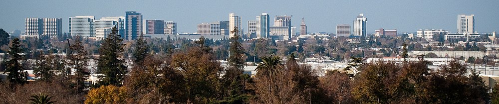
Сан-Хосе , официально город Сан-Хосе ( по-испански « Святой Иосиф »). [ 14 ] / ˌ s æ n h oʊ ˈ z eɪ , - ˈ s eɪ / SAN hoh- ZAY , - SAY ; Испанский: [saŋ xose] ), [ 15 ] — крупнейший город Северной Калифорнии как по численности населения, так и по площади. При численности населения в 2022 году 971 233 человека, [ 9 ] это самый густонаселенный город как в районе залива , так и в объединенной статистической зоне Сан-Хосе-Сан-Франциско-Окленд , население которого в 2022 году составляло 7,5 миллионов и 9,0 миллионов человек соответственно. [ 16 ] [ 17 ] — третий по численности населения город Калифорнии после Лос-Анджелеса и Сан-Диего и 13-й по численности населения в США . [ 18 ] [ 19 ] Расположенный в центре долины Санта-Клара на южном берегу залива Сан-Франциско , Сан-Хосе занимает площадь 179,97 квадратных миль (466,1 км2). 2 ). Сан-Хосе является административным центром округа Санта-Клара и основным компонентом столичного статистического района Сан-Хосе-Саннивейл-Санта-Клара с предполагаемым населением около двух миллионов жителей в 2018 году. [ 20 ]
Сан-Хосе известен своими инновациями , культурным разнообразием, [ 21 ] изобилие , [ 22 ] и солнечный и мягкий средиземноморский климат . [ 23 ] Его связь с бурно развивающейся высоких технологий, индустрией известной как Силиконовая долина. [ 24 ] побудил мэра Тома МакЭнери принять девиз города «Столица Кремниевой долины» в 1988 году для популяризации города. [ 25 ] Крупнейшие мировые технологические компании, включая Cisco Systems , eBay , Adobe Inc. , PayPal , Broadcom и Zoom, имеют свои штаб-квартиры в Сан-Хосе. Сан-Хосе, один из самых богатых крупных городов мира, имеет третий по величине ВВП на душу населения (после Цюриха и Осло ). [ 26 ] и пятый по дороговизне рынок жилья. [ 27 ] Здесь проживает одна из крупнейших в мире вьетнамских популяций за рубежом. [ 28 ] латиноамериканское сообщество, составляющее более 40% жителей города, [ 29 ] и исторические этнические анклавы, такие как Джапантаун и Маленькая Португалия .
До прихода испанцев территория вокруг Сан-Хосе долгое время была заселена народом тамиен из народа олоне в Калифорнии . Сан-Хосе был основан 29 ноября 1777 года как Пуэбло - де-Сан-Хосе-де -Гуадалупе , первый город, основанный в Калифорнии . [ 30 ] Он стал частью Мексики в 1821 году после мексиканской войны за независимость .
американцами После завоевания Калифорнии во время американо-мексиканской войны территория была передана Соединенным Штатам в 1848 году. После того, как два года спустя Калифорния получила статус штата, Сан-Хосе был назначен первой столицей штата. [ 31 ] После Второй мировой войны Сан-Хосе пережил экономический бум с быстрым ростом населения и агрессивной аннексией близлежащих городов и населенных пунктов, осуществленной в 1950-х и 1960-х годах. Бурный рост высоких технологий и электроники промышленность еще больше ускорила переход от сельскохозяйственного центра к урбанизированному мегаполису. Результаты переписи населения США 1990 года показали, что Сан-Хосе официально превзошел Сан-Франциско как самый густонаселенный город Северной Калифорнии. [ 32 ] К 1990-м годам Сан-Хосе стал мировым центром высоких технологий и интернет-индустрии и стал самой быстрорастущей экономикой Калифорнии в 2015–2016 годах. [ 33 ] В период с апреля 2020 года по июль 2022 года Сан-Хосе потерял 42 000 человек, или 4,1% своего населения, опустившись на 12-е место в рейтинге крупнейших городов. [ 34 ]
Имя
[ редактировать ]Хосе назван в честь Эль-Пуэбло-де-Сан-Хосе-де-Гуадалупе ( по-испански «Город Святого Иосифа Гваделупского Сан - »), предшественника города, который в конечном итоге располагался в районе нынешней площади Сезара Чавеса . В 19 веке в печатных изданиях использовалось написание «Сан-Хосе» как для города, так и для его одноименного поселка . [ 35 ] [ 36 ] 11 декабря 1943 года Совет США по географическим названиям постановил, что название города следует писать «Сан-Хосе», исходя из местного использования и официального включенного названия. [ 37 ]
В 1960-х и 1970-х годах некоторые жители и официальные лица выступали за возвращение к первоначальному написанию слова «Сан-Хосе» с острым ударением на букву «е», чтобы признать мексиканское происхождение города и мексиканско-американское население. 2 июня 1969 года город принял флаг, разработанный историком Клайдом Арбаклом, на котором заметно была надпись «САН-ХОСЕ, КАЛИФОРНИЯ». [ 38 ] 16 июня 1970 года Государственный колледж Сан-Хосе официально принял «Сан-Хосе» в качестве названия города, в том числе в собственном названии колледжа. [ 39 ] 20 августа 1974 года городской совет Сан-Хосе одобрил предложение Кэтрин Линквист переименовать город в Сан-Хосе. [ 40 ] [ 41 ] но неделю спустя он изменился под давлением жителей, обеспокоенных стоимостью замены пишущих машинок, документов и вывесок. [ 42 ] 3 апреля 1979 года городской совет снова принял «Сан-Хосе» в качестве написания названия города на городской печати, официальных бланках, названиях должностей и названиях отделов. [ 43 ] Еще в 2010 году в городском уставе 1965 года название муниципальной корпорации было указано как «Город Сан-Хосе» без знака ударения. [ 44 ] [ 45 ] но в более поздних изданиях был добавлен знак ударения. [ 14 ]
По соглашению, написание Сан-Хосе используется только тогда, когда имя пишется смешанными прописными и строчными буквами, но не тогда, когда имя пишется только заглавными буквами, как на логотипе города. Акцент отражает испанскую версию имени, а удаление акцентов при написании заглавными буквами когда-то было типичным для испанского языка. Хотя Сан-Хосе обычно пишется как с острым ударением над буквой «е», так и без него, официальные правила города указывают, что большую часть времени его следует писать с акцентом, и устанавливают узкие исключения, например, когда написание используется в URL-адресах. , когда имя написано заглавными буквами, когда имя используется на сайтах социальных сетей, где диакритический знак не отображается должным образом, и где Сан-Хосе является частью собственного имени другой организации или предприятия, например San Jose Chamber. торговли , который решил не использовать имя с акцентом. [ 46 ] [ 47 ] [ 48 ]
История
[ редактировать ]Доколониальный период
[ редактировать ]Сан-Хосе, как и большая часть долины Санта-Клара , был домом для группы Тамиен (также пишется как Тамиен, Тамиен) народа Олоне примерно с 4000 н.э. г. до [ 49 ] [ 50 ] [ 51 ] Тамиен говорил на тамьенском языке языковой семьи олоне .
В эпоху испанской колонизации и последующего строительства испанских миссий в Калифорнии жизнь народа Тамиен кардинально изменилась. Начиная с 1777 года, большая часть жителей Тамиена была насильственно порабощена в Миссии Санта-Клара-де-Асис или Миссии Сан-Хосе , где их крестили и обучали как католических неофитов , также известных как индейцы-миссионеры . Это продолжалось до тех пор, пока миссия не была секуляризована правительством Мексики в 1833 году. Подавляющее большинство тамиенов умерло либо от болезней в миссиях, либо в результате геноцида, спонсируемого государством . Некоторые выжившие семьи остались нетронутыми и мигрировали в Санта-Крус после того, как земли их предков были переданы испанским и мексиканским иммигрантам. [ 52 ]
Испанский период
[ редактировать ]
Калифорния была объявлена частью Испанской империи в 1542 году, когда исследователь Хуан Родригес Кабрильо нанес на карту калифорнийское побережье . В это время Альта-Калифорния и полуостров Нижняя Калифорния управлялись вместе как провинция Калифорния (исп. Provincia de las Californias ). В течение почти 200 лет Калифорния оставалась отдаленным пограничным регионом, в значительной степени контролируемым многочисленными коренными народами и в значительной степени игнорируемым правительством вице-королевства Новая Испания в Мехико . Изменение расстановки сил в Северной Америке, в том числе британско-американская победа и приобретение Северной Америки к востоку от Миссисипи после Парижского договора 1763 года , а также начало русской колонизации северо-запада Северной Америки , побудило испанские и мексиканские власти спонсировать по Экспедиция Портолы обследованию Северной Калифорнии в 1769 году. [ 53 ]
В 1776 году Калифорния была включена в состав Главного капитанства внутренних провинций , большого административного подразделения, созданного Хосе де Гальвесом , испанским министром Индии , чтобы обеспечить большую автономию приграничных земель Испанской империи . В том же году король Испании Карлос III одобрил экспедицию Хуана Баутисты де Анса для исследования района залива Сан-Франциско , чтобы выбрать места для двух будущих поселений и сопровождающей их миссии . Де Анса первоначально выбрал это место для военного поселения в Сан-Франциско, для Королевского президиума Сан-Франциско и миссии Сан-Франциско-де-Асис . На обратном пути в Мексику из Сан-Франциско де Анса выбрал места в долине Санта-Клара для гражданского поселения Сан-Хосе на восточном берегу реки Гуадалупе и миссии на ее западном берегу — Миссии Санта-Клара-де-Асис . [ 54 ]

Сан-Хосе был официально основан 29 ноября 1777 года как пуэбло Сан-Хосе-де-Гуадалупе Хосе Хоакином Морагой по приказу Антонио Марии де Букарели и Урсуа , вице-короля Новой Испании . [ 55 ] Сан-Хосе служил стратегическим поселением вдоль Эль-Камино-Реаль , соединяя военные укрепления в Президио Монтерея и Президио Сан-Франциско , а также сеть миссий Калифорнии . [ 56 ] В 1791 году из-за сильного наводнения, характерного для пуэбло, поселение Сан-Хосе было перенесено примерно на милю к югу, с центром на площади Пуэбло (современная площадь Сезара Чавеса ). [ 57 ]
В 1800 году из-за роста населения в северной части Калифорнии Диего де Борика , губернатор Калифорнии, официально разделил провинцию на две части: Альта-Калифорния ( Верхняя Калифорния ), которая в конечном итоге стала несколькими западными штатами США , и Нижняя Калифорния ( Нижняя Калифорния ), которая со временем станет двумя мексиканскими штатами .
Мексиканский период
[ редактировать ]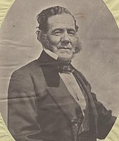
Сан-Хосе стал частью Первой Мексиканской империи в 1821 году, после Мексики в войне за независимость победы против испанской короны , а в 1824 году — частью Первой Мексиканской республики . Обладая вновь обретенной независимостью и триумфом республиканского движения, Мексика намеревалась уменьшить власть католической церкви в Альта-Калифорнии путем секуляризации калифорнийских миссий в 1833 году. [ нужна ссылка ]
В 1824 году, чтобы способствовать заселению и экономической деятельности в малонаселенной Калифорнии, мексиканское правительство начало инициативу, как для мексиканских, так и для иностранных граждан, по заселению незанятых земель в Калифорнии. тридцать восемь грантов на землю ранчо было выдано Между 1833 и 1845 годами в долине Санта-Клара , 15 из которых располагались в пределах границ современного Сан-Хосе. Среди тех, кому были предоставлены земли ранчо в долине Санта-Валле, были многочисленные выдающиеся исторические личности, в том числе Джеймс А. Форбс , основатель Лос-Гатос, Калифорния (предоставлено ранчо Потреро де Санта-Клара ), Антонио Суноль , Алькальде Сан-Хосе (предоставлено ранчо Лос-Кочес ), и Хосе Мария Альвисо , алькальде Сан-Хосе (предоставлено ранчо Милпитас ). [ нужна ссылка ]
В 1835 году население Сан-Хосе, насчитывавшее около 700 человек, включало 40 иностранцев, преимущественно американцев и англичан . К 1845 году население пуэбло увеличилось до 900 человек, в первую очередь за счет американской иммиграции. Иностранные поселения в Сан-Хосе и Калифорнии быстро меняли калифорнийское общество, принося с собой расширение экономических возможностей и иностранной культуры. [ 58 ]
К 1846 году коренные жители Калифорнии уже давно выражали свою обеспокоенность по поводу наводнения калифорнийского общества его растущей и богатой англо-американской общиной. [ 59 ] Во время восстания «Медвежьего флага» в 1846 году капитан Томас Фэллон повел девятнадцать добровольцев из Санта-Крус в поселок Сан-Хосе, который его войска легко захватили. Поднятие флага Калифорнийской Республики положило конец мексиканскому правлению в Альта-Калифорнии 14 июля 1846 года. [ 60 ] [ 61 ]
Американский период
[ редактировать ]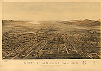

К концу 1847 года завоевание Калифорнии Соединенными Штатами было завершено, поскольку американо-мексиканская война подошла к концу. [ 50 ] В 1848 году по Договору Гуадалупе-Идальго Калифорния официально уступила Калифорнию Соединенным Штатам в рамках Мексиканской уступки . Хосе стал столицей неорганизованной территории Калифорнии 15 декабря 1849 года Сан - . С принятием Калифорнии в Союз 9 сентября 1850 года Сан-Хосе стал первой столицей штата. [ 62 ]
27 марта 1850 года был зарегистрирован Сан-Хосе . Он был зарегистрирован в тот же день, что и Сан-Диего и Бенисия ; вместе эти три города последовали за Сакраменто как первые объединенные города Калифорнии. [ 63 ] Джозайя Белден , который поселился в Калифорнии в 1842 году после прохождения Калифорнийской тропы в составе партии Бартлсона и позже приобрел состояние, был первым мэром города. [ 64 ] Сан-Хосе на короткое время был первой столицей штата Калифорния, и законодатели собирались в городе с 1849 по 1851 год ( Монтеррей был столицей в период Испанской Калифорнии и Мексиканской Калифорнии ). [ 65 ] Первой столицы больше не существует; исторических указателя Сейчас на этом месте находится Пласа-де-Сезар Чавес, на котором есть два , указывающих, где впервые встретилось законодательное собрание штата Калифорния. [ 66 ]
В период с 1900 по 1910 год Сан-Хосе служил центром новаторских изобретений, инноваций и достижений в полетах как легче воздуха, так и тяжелее воздуха. Эту деятельность возглавляли главным образом Джон Монтгомери и его коллеги. В его честь город Сан-Хосе установил парк Монтгомери, памятник на дорогах Сан-Фелипе и Йерба-Буэна, а также начальную школу Джона Дж. Монтгомери. В этот период Сан-Хосе также стал центром инноваций в области механизации и индустриализации сельскохозяйственного и пищевого оборудования. [ 67 ]
Хотя Сан-Хосе не пострадал так сильно, как Сан-Франциско, он также понес значительный ущерб от землетрясения в Сан-Франциско 1906 года . Более 100 человек погибли в приюте Агньюс (позже государственная больница Агньюс) после обрушения стен и крыши. [ 68 ] и трехэтажное каменно-кирпичное здание средней школы Сан-Хосе также было разрушено. Период Второй мировой войны был бурным; Американцы японского происхождения, в основном из Джапантауна, были отправлены в лагеря для интернированных , в том числе будущий мэр Норман Минета . , произошедших в Лос-Анджелесе После беспорядков , летом 1943 года произошло антимексиканское насилие. В 1940 году Бюро переписи населения сообщило, что население Сан-Хосе составляет 98% белых. [ 69 ]

С началом Второй мировой войны экономика города перешла от сельского хозяйства ( консервный завод Дель Монте был крупнейшим работодателем и закрылся в 1999 году). [ 70 ] ) промышленному производству с заключением контракта с Food Machinery Corporation (позже известной как FMC Corporation ) военным министерством США на постройку 1000 гусеничных десантных машин . [ 71 ] После Второй мировой войны компания FMC (позже United Defense , а в настоящее время BAE Systems ) продолжала работать в качестве оборонного подрядчика , а предприятия в Сан-Хосе занимались проектированием и производством военных платформ, таких как бронетранспортер M113 , боевая машина Брэдли и различные подсистемы вооруженных сил. М1 «Абрамс» . Боевой танк [ 72 ]
IBM открыла свои первые предприятия на Западном побережье в Сан-Хосе в 1943 году, открыв завод по производству перфокарт открыла исследовательскую лабораторию IBM. в центре города, а в 1952 году Рейнольд Б. Джонсон и его команда разработали систему хранения данных с прямым доступом для компьютеров. [ 73 ] изобретение RAMAC 305 и жесткого диска ; технологическая сторона экономики Сан-Хосе выросла. [ 74 ]
В 1950-х и 1960-х годах городской менеджер AP «Dutch» Хаманн руководил крупной кампанией роста города. Город аннексировал прилегающие территории, такие как Альвисо и Кембрийский парк , предоставив большие территории для пригородов. Реакция против экономического роста на последствия быстрого развития возникла в 1970-х годах, ее отстаивали мэры Норман Минета и Джанет Грей Хейс . Несмотря на установление границ роста городов , плату за строительство и объединение Кэмпбелла и Купертино , развитие не замедлилось, а, скорее, было направлено в уже включенные районы. [ 71 ]
Положение Сан-Хосе в Кремниевой долине спровоцировало дальнейший экономический рост и рост населения. Результаты переписи населения США 1990 года показали, что Сан-Хосе впервые обогнал Сан-Франциско как самый густонаселенный город в районе залива. [ 32 ] Этот рост привел к самому высокому увеличению стоимости жилья в стране - 936% в период с 1976 по 2001 год. [ 75 ] Усилия по увеличению плотности населения продолжались и в 1990-е годы, когда в обновленном городском плане 1974 года границы роста городов остались нетронутыми, а избиратели отклонили избирательную меру по смягчению ограничений на застройку в предгорьях. По состоянию на 2006 год шестьдесят процентов жилья, построенного в Сан-Хосе с 1980 года, и более трех четвертей жилья, построенного с 2000 года, представляли собой многоквартирные структуры, что отражает политическую склонность к принципам планирования разумного роста . [ 76 ]
География
[ редактировать ]
Сан-Хосе находится по адресу 37 ° 20'10 "N 121 ° 53'26" W / 37,33611 ° N 121,89056 ° W . Сан-Хосе расположен в долине Санта-Клара , в южной части залива Северной Калифорнии. Самая северная часть Сан-Хосе касается залива Сан-Франциско в Альвизо , хотя большая часть города находится вдали от берега залива. По данным Бюро переписи населения США , город имеет общую площадь 180,0 квадратных миль (466 км²). 2 ), что делает его четвертым по величине городом Калифорнии по площади (после Лос-Анджелеса, Сан-Диего и Калифорния-Сити ). [ 18 ]
Сан-Хосе расположен между разломом Сан-Андреас , источником землетрясения Лома-Приета в 1989 году , и разломом Калаверас . Сан-Хосе сотрясают умеренные землетрясения в среднем один или два раза в год. Эти землетрясения происходят к востоку от города, на ползучем участке разлома Калаверас, который является основным источником сейсмической активности в Северной Калифорнии. 14 апреля 1984 года в 13:15 по местному времени землетрясение магнитудой 6,2 произошло в разломе Калаверас недалеко от горы Гамильтон в Сан-Хосе. [ 77 ] Как описано ранее, самое серьезное землетрясение 1906 года повредило многие здания в Сан-Хосе. Ранее значительные землетрясения сотрясали город в 1839, 1851, 1858, 1864, 1865, 1868 и 1891 годах. Землетрясение в Дейли-Сити 1957 года нанесло некоторый ущерб. Землетрясение в Лома-Приете в 1989 году также нанесло некоторый ущерб некоторым частям города.
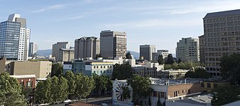
Городской пейзаж
[ редактировать ]Расширение Сан-Хосе было осуществлено по проекту «голландца» Хамана , городского менеджера с 1950 по 1969 год. За время его правления, когда его сотрудники назывались «голландской танковой дивизией», город аннексировал собственность 1389 раз. [ 78 ] рост города с 17 до 149 квадратных миль (от 44 до 386 км²). 2 ), [ 79 ] поглотив названные выше сообщества, изменив их статус на «кварталы».
Говорят, Сан-Хосе станет вторым Лос-Анджелесом. Поверьте, я сделаю все, что в моих силах, чтобы это осуществилось.
— «Голландец» Хаманн, 1965 г. [ 80 ]
Налоги с продаж были основным источником дохода. Хаманн должен был определить, где будут располагаться основные торговые районы, а затем аннексировать узкие полосы земли вдоль основных дорог, ведущих к этим местам, проталкивая щупальца через долину Санта-Клары и, в свою очередь, блокируя расширение прилегающих населенных пунктов. [ 81 ]
Говорили, что во время его правления городской совет будет голосовать по решению Хаманна. В 1963 году штат Калифорния ввел комиссии по формированию местных агентств по всему штату, но в основном для того, чтобы попытаться поддерживать порядок в условиях агрессивного роста Сан-Хосе. В конце концов, политические силы, выступающие против экономического роста, выросли, поскольку местные районы объединились, чтобы избрать своих собственных кандидатов, что положило конец влиянию Хаманна и привело к его отставке. [ 82 ] Хотя работа не была завершена, тенденция была задана. Город определил свою сферу влияния во всех направлениях, иногда хаотично оставляя некорпоративные карманы, которые будут поглощены чудовищем, иногда даже вопреки возражениям жителей. [ 78 ]
Основные магистрали города включают Монтерей-роуд , коридор бульвара Стивенс-Крик / Сан-Карлос-стрит , коридор Санта-Клара-стрит / Алум-Рок-авеню , скоростную автомагистраль Альмаден , скоростную автомагистраль Капитолия и 1-ю улицу (Сан-Хосе) .
Топография
[ редактировать ]


течет Река Гуадалупе от гор Санта-Крус , течет на север через Сан-Хосе и заканчивается в заливе Сан-Франциско в Альвисо . Вдоль южной части реки расположен район долины Альмаден , первоначально названный в честь ртутных рудников, которые производили ртуть, необходимую для извлечения золота из кварца во время Калифорнийской золотой лихорадки , а также гремучие ртутные капсюли-детонаторы и детонаторы для армии США с 1870 по 1870 годы. 1945 год. [ 83 ] К востоку от реки Гуадалупе Койот-Крик также течет на юг залива Сан-Франциско и берет начало на горе Сайзер возле государственного парка Генри У. Коу и окружающих холмов в хребте Диабло , к северо-востоку от Морган-Хилл, Калифорния .
Самая низкая точка Сан-Хосе находится на высоте 13 футов (4,0 м) ниже уровня моря в заливе Сан-Франциско в Альвизо; [ 84 ] самая высокая - 2125 футов (648 м). [ 85 ] Из-за близости к Ликской обсерватории на вершине горы Гамильтон в Сан-Хосе предприняли несколько шагов по снижению светового загрязнения , включая замену всех уличных фонарей и наружного освещения в частных застройках натриевыми лампами низкого давления . [ 86 ] В знак признания усилий города астероид 6216 Сан-Хосе . в честь города был назван [ 87 ]
В городе Сан-Хосе есть четыре отдельные долины: долина Альмаден, расположенная на юго-западной окраине города; Вечнозеленая долина на юго-востоке, вся внутренняя часть которой холмистая; Долина Санта-Клара, которая включает в себя плоскую основную городскую территорию Южного залива; и сельская Долина Койотов на крайней южной окраине города. [ 88 ]
Обширная засуха в Калифорнии в сочетании с осушением водохранилища на озере Андерсон для сейсмического города ремонта ухудшили водную безопасность . [ 89 ] [ 90 ] Сан-Хосе страдает от отсутствия осадков и нехватки воды до такой степени, что к лету 2022 года у некоторых жителей может закончиться вода в домах. [ 91 ]
Климат
[ редактировать ]Сан-Хосе, как и большая часть территории залива, имеет средиземноморский климат ( Köppen : Csb ), [ 92 ] [ 93 ] с теплым и жарким сухим летом и прохладной влажной зимой. В Сан-Хосе в среднем 298 солнечных дней и средняя годовая температура 61,4 ° F (16,3 ° C). Он расположен внутри страны, с трех сторон окружен горами и не выходит к Тихому океану, как Сан-Франциско. В результате город несколько более защищен от дождя, едва избегая холодного полузасушливого ( BSk ) климата. [ 92 ]
Как и большая часть района залива, Сан-Хосе состоит из десятков микроклиматов . Из-за более заметной дождевой тени от гор Санта-Крус в центре Сан-Хосе выпадает самый слабый дождь в городе, а в южном Сан-Хосе, находящемся всего в 10 милях (16 км), выпадает больше осадков и несколько более экстремальные температуры.
Среднемесячная дневная температура колеблется от примерно 50 ° F (10 ° C) в декабре и январе до примерно 70 ° F (21 ° C) в июле и августе. [ 94 ] Самая высокая температура, когда-либо зарегистрированная в Сан-Хосе, составила 109 ° F (43 ° C) 6 сентября 2022 года; самая низкая была 18 ° F (-7,8 ° C) 6 января 1894 года. В среднем 2,7 утра в году температура падает до точки замерзания или ниже нее; и шестнадцать дней после полудня, когда максимальная температура достигает или превышает 90 ° F или 32,2 ° C. Суточные колебания температуры гораздо шире, чем вдоль побережья или в Сан-Франциско, но все же они меньше того, что наблюдается в Центральной долине .
Осадки «года дождя» колебались от 4,83 дюйма (122,7 мм) с июля 1876 по июнь 1877 года до 30,30 дюйма (769,6 мм) с июля 1889 по июнь 1890 года, хотя на нынешнем месте с 1893 года диапазон составляет от 5,33 дюйма (135,4 мм). ) в «год дождей» 2020–21 гг. 30,25 дюйма (768,3 мм) в «дождливый год» 1982–83. 2020-2021 год был годом с самым низким количеством осадков за всю историю за 127 лет регистрации осадков в Сан-Хосе. Наибольшее количество осадков за месяц составило 12,38 дюйма (314,5 мм) в январе 1911 года. Максимальное количество осадков за 24 часа составило 3,60 дюйма (91,4 мм) 30 января 1968 года. 16 августа 2020 года произошла одна из самых распространенных и сильных гроз. События в недавней истории Залива произошли, когда нестабильная влажная воздушная масса поднялась с юга и вызвала множественные сухие грозы. [ 95 ] что привело к возгоранию множества пожаров из-за более чем 300 ударов молний на окружающих холмах. На полную ликвидацию пожаров молниеотводного комплекса CZU потребовалось почти 5 месяцев. Было сожжено более 86 000 акров и разрушено почти 1500 зданий. [ 96 ] [ 97 ]
Уровень снега падает до 4000 футов (1220 м) над уровнем моря или ниже, иногда покрывая близлежащую гору Гамильтон и, реже, горы Санта-Крус , снегом, который обычно держится несколько дней. Снег затруднит движение транспорта по шоссе № 17 в направлении Санта-Крус . Снег в Сан-Хосе выпадает редко; последний раз снег, оставшийся на земле, был 5 февраля 1976 года, когда многие жители города видели снег на крышах автомобилей и крыш до 3 дюймов (0,076 м). Официальная наблюдательная станция измерила всего 0,5 дюйма (0,013 м) снега. [ 98 ]
| Климатические данные для международного аэропорта Сан-Хосе (KSJC), Калифорния (нормы 1991–2020 гг., Экстремальные значения с 1893 г. по настоящее время) | |||||||||||||
|---|---|---|---|---|---|---|---|---|---|---|---|---|---|
| Месяц | Ян | февраль | Мар | апрель | Может | июнь | июль | август | Сентябрь | октябрь | ноябрь | декабрь | Год |
| Рекордно высокий °F (°C) | 79 (26) |
81 (27) |
89 (32) |
95 (35) |
102 (39) |
107 (42) |
108 (42) |
105 (41) |
109 (43) |
101 (38) |
85 (29) |
79 (26) |
109 (43) |
| Среднее максимальное °F (°C) | 68.2 (20.1) |
73.2 (22.9) |
79.1 (26.2) |
85.7 (29.8) |
89.8 (32.1) |
96.9 (36.1) |
95.0 (35.0) |
95.7 (35.4) |
95.7 (35.4) |
89.4 (31.9) |
77.5 (25.3) |
68.0 (20.0) |
99.8 (37.7) |
| Среднесуточный максимум °F (°C) | 59.8 (15.4) |
62.4 (16.9) |
65.9 (18.8) |
69.2 (20.7) |
73.8 (23.2) |
79.1 (26.2) |
80.8 (27.1) |
81.4 (27.4) |
80.7 (27.1) |
75.8 (24.3) |
66.1 (18.9) |
59.5 (15.3) |
71.2 (21.8) |
| Среднесуточное значение °F (°C) | 50.8 (10.4) |
53.2 (11.8) |
56.1 (13.4) |
58.8 (14.9) |
63.0 (17.2) |
67.3 (19.6) |
69.5 (20.8) |
70.0 (21.1) |
69.0 (20.6) |
64.3 (17.9) |
55.9 (13.3) |
50.6 (10.3) |
60.7 (15.9) |
| Среднесуточный минимум °F (°C) | 41.8 (5.4) |
43.9 (6.6) |
46.3 (7.9) |
48.4 (9.1) |
52.1 (11.2) |
55.5 (13.1) |
58.1 (14.5) |
58.6 (14.8) |
57.2 (14.0) |
52.7 (11.5) |
45.7 (7.6) |
41.7 (5.4) |
50.2 (10.1) |
| Средний минимум °F (°C) | 32.6 (0.3) |
35.0 (1.7) |
38.1 (3.4) |
41.3 (5.2) |
46.1 (7.8) |
50.1 (10.1) |
53.8 (12.1) |
53.9 (12.2) |
50.8 (10.4) |
45.5 (7.5) |
36.8 (2.7) |
32.2 (0.1) |
30.7 (−0.7) |
| Рекордно низкий °F (°C) | 18 (−8) |
24 (−4) |
25 (−4) |
26 (−3) |
32 (0) |
33 (1) |
40 (4) |
39 (4) |
35 (2) |
30 (−1) |
22 (−6) |
19 (−7) |
18 (−8) |
| Среднее количество осадков в дюймах (мм) | 2.97 (75) |
3.24 (82) |
2.64 (67) |
1.24 (31) |
0.54 (14) |
0.17 (4.3) |
0.01 (0.25) |
0.03 (0.76) |
0.07 (1.8) |
0.80 (20) |
1.36 (35) |
3.07 (78) |
16.14 (410) |
| Среднее количество дождливых дней (≥ 0,01 дюйма) | 10.2 | 11.5 | 9.3 | 6.4 | 4.0 | 1.2 | 0.2 | 0.4 | 0.9 | 2.7 | 6.9 | 10.7 | 64.4 |
| Источник: НОАА [ 99 ] [ 100 ] | |||||||||||||
Районы и районы
[ редактировать ]Город обычно делится на следующие районы: Центральный Сан-Хосе (с центром в центре Сан-Хосе ), Западный Сан-Хосе , Северный Сан-Хосе , Восточный Сан-Хосе и Южный Сан-Хосе . Многие районы и кварталы Сан-Хосе ранее были некорпоративными сообществами или отдельными муниципалитетами, которые позже были присоединены к городу.
Помимо упомянутых выше, некоторые известные поселения в Сан-Хосе включают Джапантаун , Роуз Гарден , Мидтаун Сан-Хосе , Уиллоу-Глен , Нэгли-Парк , Бербанк , Винчестер , Алвизо , Ист-Футхиллс , Квасцы Рок , Коммуникейшн-Хилл , Маленькая Португалия , Долина цветения , Кембрийский период , долина Альмаден , Литл-Сайгон , долина Силвер-Крик , долина Эвергрин , Мейфэр , Эденвейл , Санта-Тереза , Семь Деревьев , Долина Койотов и Берриесса . Особым этническим анклавом в Сан-Хосе является район Вашингтон-Гуадалупе , расположенный непосредственно к югу от округа Софа ; В этом районе проживает сообщество выходцев из Латинской Америки , сосредоточенное на Уиллоу-стрит.
- Выбор районов Сан-Хосе
-

-
-
-

-

-

-

-

-
-

-

-
-

-

-

-

-


Парки
[ редактировать ]


Сан-Хосе владеет около 15 950 акров (6 455 га) парковой зоны в черте города, включая часть обширного национального заповедника дикой природы Дона Эдвардса в заливе Сан-Франциско . Старейшим парком города является Alum Rock Park , основанный в 1872 году. [ 101 ] В своем рейтинге ParkScore за 2013 год The Trust for Public Land национальная организация по охране земель сообщила, что Сан-Хосе делит с Альбукерке и Омахой 11-е место среди лучших парковых систем среди 50 самых густонаселенных городов США. [ 102 ]
- Парк округа Альмаден Ртуть , 4147 акров (16,78 км 2). 2 ) бывших ртутных рудников в Южном Сан-Хосе (управляемых и обслуживаемых Департаментом парков и отдыха округа Санта-Клара ).
- Парк Алум Рок , 718 акров (2,91 км 2). 2 ) в Восточном Сан-Хосе, старейшем муниципальном парке Калифорнии и одном из крупнейших муниципальных парков США.
- Детский музей открытий представляет собой открытый парк, где представлена крупнейшая в мире постоянная игра «Монополия», согласно Книге рекордов Гиннеса. [ 103 ] В число смотрителей этого аттракциона входит некоммерческая группа 501 (c) 3 «Монополия в парке».
- Circle of Palms Plaza , кольцо пальм, окружающих печать штата Калифорния, и историческая достопримечательность на месте первой столицы штата.
- Фермерский парк Эммы Пруш , 43,5 акра (17,6 га) в Восточном Сан-Хосе. Подаренный Эммой Пруш для демонстрации сельскохозяйственного прошлого долины, он включает в себя 4-х амбар (самый большой в Сан-Хосе), общественные сады, фруктовый сад с редкими плодами, демонстрационные сады, места для пикников и просторы лужайки. [ 104 ] По парку свободно гуляют куры, утки и павлины.
- Field Sports Park, единственный государственный полигон округа Санта-Клара, расположенный на юге Сан-Хосе. [ 105 ]
- Парк Ирис Чанг, расположенный в Северном Сан-Хосе, посвящен памяти Ирис Шун-Ру Чанг , автора книги «Похищение Нанкина» и жительницы Сан-Хосе.
- Парк Келли , в том числе разнообразные объекты, такие как парк и зоопарк Хэппи Холлоу (парк развлечений, ориентированный на детей), Сад японской дружбы (Парк Келли) , Исторический парк в парке Келли и Португальский исторический музей на территории исторического парка.
- Парк Марсьяль Коттл , бывшая сельскохозяйственная ферма, в Южном Сан-Хосе. Управляется Департаментом парков и отдыха округа Санта-Клара.
- Мемориальный парк Оук-Хилл , старейшее светское кладбище Калифорнии.
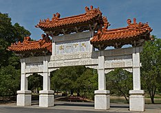
- Оверфельдские сады , в том числе Китайский культурный сад
- На площади Сезара Чавеса , небольшом парке в центре города, проводятся концерты на открытом воздухе и «Рождество в парке». выставка
- Raging Waters , аквапарк с водными горками и другими водными аттракционами. Он находится в озера Каннингем. парке
- Парк Розенкрейцеров , почти целый городской квартал в районе Розового сада; Парк представляет собой комплекс египетской и мавританской архитектуры, окруженный лужайками, розариями, скульптурами и фонтанами, и включает в себя Египетский музей розенкрейцеров , планетарий, исследовательскую библиотеку, Сад мира и Центр посетителей.
- Муниципальный розарий Сан-Хосе , 5 + 1 ⁄ 2 акра (22 000 м²) 2 ) парк в районе Розового сада с более чем 4000 кустами роз.
Тропы
[ редактировать ]
По данным исследования Walk Score, проведенного в 2011 году , Сан-Хосе занял девятнадцатое место среди 50 крупнейших городов США по пешеходной доступности. [ 106 ]
Сеть троп Сан-Хосе, состоящая из 60 миль (100 км) маршрутов для отдыха и активного транспорта по всему городу. [ 107 ] Основные маршруты сети включают в себя:
- Тропа Койот-Крик
- Тропа по реке Гуадалупе
- Тропа Лос-Гатос-Крик
- Тропа Лос-Аламитос-Крик
- Тропа Пенанс-Крик
- Тропа долины Силвер-Крик
Эта большая городская сеть троп, признанная журналом Prevention Magazine крупнейшей в стране, связана с тропами в соседних юрисдикциях и многими сельскими тропами на окружающих открытых пространствах и в предгорьях. Несколько систем троп в сети обозначены как часть Национальной рекреационной тропы, а также региональных троп, таких как тропа залива Сан-Франциско и тропа хребта района залива.
Дикая природа
[ редактировать ]Ранние письменные документы фиксируют местное присутствие мигрирующего лосося в Рио-Гуадалупе еще в 18 веке. [ 108 ] И стальной лосось ( Oncorhynchus mykiss ), и королевский лосось сохранились в реке Гуадалупе , что делает Сан-Хосе самым южным крупным городом США с известными нерестилищами лосося, а другими городами являются Анкоридж ; Сиэтл ; Портленд и Сакраменто . [ 109 ] ) в количестве до 1000 особей Каждую осень 1990-х годов стаи чавычи или королевского лосося ( Oncorhynchus tshawytscha плавали вверх по реке Гуадалупе, но в нынешнее десятилетие почти исчезли, по-видимому, доступ к местам размножения был заблокирован непроходимыми водопропускными трубами, плотинами и широкими, открытыми и плоские каналы с бетонным покрытием, установленные водным районом долины Санта-Клара . [ 110 ] В 2011 году было снято на видео нерест небольшого количества чавычи под мостом на Джулиан-стрит. [ 111 ]
Защитник природы Роджер Кастильо, обнаруживший останки мамонта на берегу реки Гуадалупе в 2005 году, обнаружил, что стадо лосей туле ( Cervus canadensis ) повторно заселило холмы южного Сан-Хосе к востоку от шоссе 101 в начале 2019 года. [ 112 ]
На южной окраине Сан-Хосе Долина Койотов представляет собой коридор миграции диких животных между горами Санта-Крус и хребтом Диабло . [ 113 ] [ 114 ]
Демография
[ редактировать ]| Перепись | Поп. | Примечание | %± |
|---|---|---|---|
| 1870 | 9,089 | — | |
| 1880 | 12,567 | 38.3% | |
| 1890 | 18,060 | 43.7% | |
| 1900 | 21,500 | 19.0% | |
| 1910 | 28,946 | 34.6% | |
| 1920 | 39,642 | 37.0% | |
| 1930 | 57,651 | 45.4% | |
| 1940 | 68,457 | 18.7% | |
| 1950 | 95,280 | 39.2% | |
| 1960 | 204,196 | 114.3% | |
| 1970 | 459,913 | 125.2% | |
| 1980 | 629,400 | 36.9% | |
| 1990 | 782,248 | 24.3% | |
| 2000 | 894,943 | 14.4% | |
| 2010 | 945,942 | 5.7% | |
| 2020 | 1,013,240 | 7.1% | |
| 2023 г. (оценка) | 969,655 | [ 115 ] | −4.3% |
| Десятилетняя перепись населения США [ 116 ] 2010–2020 [ 9 ] | |||
В 2022 году Бюро переписи населения США опубликовало новые оценки численности населения. При общей численности населения 971 233 человека, [ 117 ] В Сан-Хосе наблюдалось сокращение населения на 4,1% после переписи 2020 года. Некоторые причины этого снижения заключаются в том, что люди покидают этот район в более доступные города и имеют более удаленные возможности для работы. [ 118 ]
| Исторический расовый состав | 2020 [ 9 ] | 2010 [ 119 ] | 1990 [ 69 ] | 1970 [ 69 ] | 1940 [ 69 ] |
|---|
2020
[ редактировать ]| Раса/этническая принадлежность ( NH = неиспаноязычный ) | Поп 2000 [ 120 ] | Поп 2010 [ 121 ] | Поп 2020 [ 122 ] | % 2000 | % 2010 | % 2020 |
|---|---|---|---|---|---|---|
| Только белый (Нью-Хэмпшир) | 322,534 | 271,382 | 236,095 | 36.04% | 28.69% | 23.30% |
| Только черный или афроамериканец (Нью-Хэмпшир) | 29,495 | 27,508 | 27,422 | 3.30% | 2.91% | 2.71% |
| Только коренные американцы или коренные жители Аляски (Нью-Хэмпшир) | 2,959 | 2,255 | 1,921 | 0.33% | 0.24% | 0.19% |
| Только азиаты (Нью-Хэмпшир) | 238,378 | 300,022 | 386,993 | 26.64% | 31.72% | 38.19% |
| Один житель островов Тихого океана (Нью-Хэмпшир) | 3,093 | 3,492 | 3,460 | 0.35% | 0.37% | 0.34% |
| Только другая раса (Нью-Хэмпшир) | 1,699 | 1,820 | 4,808 | 0.19% | 0.19% | 0.47% |
| Смешанная раса или многорасовая принадлежность (НГ) | 26,796 | 25,827 | 36,275 | 2.99% | 2.73% | 3.58% |
| Латиноамериканец или латиноамериканец (любая раса) | 269,989 | 313,636 | 316,266 | 30.17% | 33.16% | 31.21% |
| Общий | 894,943 | 945,942 | 1,013,240 | 100.00% | 100.00% | 100.00% |
2010
[ редактировать ]

Перепись населения США 2010 года [ 123 ] сообщил, что в Сан-Хосе проживает 945 942 человека. Плотность населения составила 5256,2 человека на квадратную милю (2029,4/км2). 2 ). Расовый состав жителей Сан-Хосе был 404 437 (42,8%) белых , 303 138 (32,0%) азиатов (10,4% вьетнамцев , 6,7% китайцев , 5,6% филиппинцев , 4,6% индийцев , 1,2% корейцев , 1,2% японцев , 0,3% камбоджийцев , 0,2 %). % Тайский , 0,2% Пакистанцы , 0,2% лаосцы ), 30 242 (3,2%) афроамериканцы , 8 297 (0,9%) коренные американцы , 4017 (0,4%) жители островов Тихого океана , 148 749 (15,7%) представители других рас и 47 062 (5,0%) представители двух и более рас. гонки. Было 313 636 жителей латиноамериканского или латиноамериканского происхождения (33,2%). 28,2% населения города имели мексиканское происхождение; Следующими по величине латиноамериканскими группами были группы сальвадорского (0,7%) и пуэрториканского (0,5%) происхождения. В 2010 году белые неиспаноязычные составляли 28,7% населения. [ 119 ] по сравнению с 75,7% в 1970 году. [ 69 ]
Перепись показала, что 932 620 человек (98,6% населения) жили в домашних хозяйствах, 9 542 (1,0%) проживали в неинституционализированных групповых кварталах, а 3780 (0,4%) были институционализированы. Насчитывалось 301 366 домохозяйств, из которых в 122 958 (40,8%) проживали дети в возрасте до 18 лет, 162 819 (54,0%) составляли разнополые супружеские пары , живущие вместе, 37 988 (12,6%) имели домохозяйку без мужа. В настоящее время у 18 702 (6,2%) домохозяином был мужчина без жены. Было 16 900 (5,6%) не состоящих в браке партнерств противоположного пола и 2 458 (0,8%) однополых супружеских пар или партнерств . 59 385 домохозяйств (19,7%) состояли из отдельных лиц, а в 18 305 (6,1%) проживали одни люди в возрасте 65 лет и старше. Средний размер домохозяйства составил 3,09. Насчитывалось 219 509 семей (72,8% всех домохозяйств); средний размер семьи составлял 3,54 человека.
Возрастное распределение города было следующим: 234 678 человек (24,8%) были в возрасте до 18 лет, 89 457 человек (9,5%) в возрасте от 18 до 24 лет, 294 399 человек (31,1%) в возрасте от 25 до 44 лет, 232 166 человек (24,5% ) в возрасте от 45 до 64 лет и 95 242 человека (10,1%) в возрасте 65 лет и старше. Средний возраст составил 35,2 года. На каждые 100 женщин приходилось 101,1 мужчин. На каждые 100 женщин в возрасте 18 лет и старше приходилось 99,8 мужчин.
Было 314 038 единиц жилья со средней плотностью 1745,0 на квадратную милю (673,7/км²). 2 ), из них 176 216 (58,5%) были заняты собственниками, а 125 150 (41,5%) — арендаторами. Доля вакантных домовладельцев составила 1,6%; доля вакантных арендных площадей составила 4,3%. 553 436 человек (58,5% населения) проживали в собственном жилье и 379 184 человека (40,1%) - в арендном жилье.
2000
[ редактировать ]


Согласно переписи населения США 2000 года , в городе проживало 894 943 человека, 276 598 домашних хозяйств и 203 576 семей. [ 124 ]
Плотность населения составила 5117,9 человек на квадратную милю (1976,0/км2). 2 ). Было 281 841 единиц жилья со средней плотностью 1611,8 на квадратную милю (622,3/км2). 2 ). Из 276 598 домохозяйств 38,3% имели детей в возрасте до 18 лет, проживающих с ними, 56,0% составляли супружеские пары, живущие вместе, 11,7% имели домохозяйку без мужа и 26,4% не были семейными. 18,4% всех домохозяйств состояли из отдельных лиц, а в 4,9% проживали одни люди в возрасте 65 лет и старше. Средний размер домохозяйства составлял 3,20, а средний размер семьи - 3,62.
В городе возрастное распределение населения показывает 26,4% моложе 18 лет, 9,9% от 18 до 24 лет, 35,4% от 25 до 44 лет, 20,0% от 45 до 64 лет и 8,3% людей в возрасте 65 лет и старше. старше. Средний возраст составил 33 года. На каждые 100 женщин приходилось 103,3 мужчины. На каждые 100 женщин в возрасте 18 лет и старше приходилось 102,5 мужчин.
По оценкам 2007 года, средний доход семьи в городе был самым высоким в США среди городов с населением более четверти миллиона человек и составлял 76 963 доллара в год. Средний доход семьи составлял 86 822 доллара. [ 125 ] Средний доход мужчин составлял 49 347 долларов против 36 936 долларов у женщин. Доход на душу населения в городе составил 26 697 долларов. Около 6,0% семей и 8,8% населения находились за чертой бедности, в том числе 10,3% лиц в возрасте до 18 лет и 7,4% лиц в возрасте 65 лет и старше.
Экономика
[ редактировать ]


Доли CSA Сан-Хосе и Сан-Франциско были третьей по величине городской экономикой страны по состоянию на 2018 год с ВВП в 1,03 триллиона долларов. [ 126 ] Из более чем 500 основных статистических областей США этот CSA имел один из самых высоких показателей ВВП на душу населения в 2018 году — 106 757 долларов США. [ 126 ]
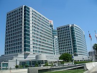
San Jose is a United States Foreign-Trade Zone. The city received its Foreign Trade Zone grant from the U.S. Federal Government in 1974, making it the 18th foreign-trade zone established in the United States. Under its grant, the City of San Jose is granted jurisdiction to oversee and administer foreign trade in Santa Clara County, Monterey County, San Benito County, Santa Cruz County, and in the southern parts of San Mateo County and Alameda County.[127]
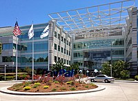
San Jose hosts many companies with more than 1,000 employees, including the headquarters of:
San Jose also hosts major facilities for Becton Dickinson, Ericsson, Hewlett Packard Enterprise, Hitachi, IBM, Kaiser Permanente, KLA Tencor, Lockheed Martin, Nippon Sheet Glass, and Qualcomm. The North American headquarters of Samsung Semiconductor are located in San Jose.[128][129] Approximately 2000 employees will work at the new Samsung campus which opened in 2015.
Other large companies based in San Jose include:
- Align Technology
- Atmel
- Bloom Energy
- CEVA
- Cypress Semiconductor
- Cohesity, Echelon
- Extreme Networks
- GlobalLogic
- Harmonic
- Integrated Device Technology
- Maxim Integrated
- Micrel
- Move
- Netgear
- Novellus Systems
- Nutanix
- Oclaro
- OCZ
- Quantum
- SunPower
- Sharks Sports and Entertainment
- Supermicro
- Tessera Technologies
- TiVo
- Ultratech
- VeriFone
- Viavi Solutions
- Zoom Video Communications
- Zscaler
Sizable government employers include the city government, Santa Clara County, and San Jose State University.[130] Acer's United States division has its offices in San Jose.[131] Prior to its closing, Netcom had its headquarters in San Jose.[132][133]
On July 31, 2015, Cupertino-based Apple Inc. purchased a 40-acre site in San Jose.[134] The site, which is bare land, will be the site of an office and research campus where it is estimated that up to 16,000 employees will be located. Apple paid $138.2 million for the site.[134] The seller, Connecticut-based Five Mile Capital Partners, paid $40 million for the site in 2010.[135]
Wealth
[edit]
It is situated in the most affluent county in California and one of the most affluent counties in the United States.[136][137][138]
With a median home price of $1,085,000[139] and the highest percentage of million-dollar (or more) homes in the United States,[140] San Jose has the most expensive housing market in the United States and the fifth most expensive housing market in the world.[141][142][143]
The cost of living in San Jose and the surrounding areas is among the highest in California and the nation, according to 2004 data.[144] Housing costs are the primary reason for the high cost of living, although the costs in all areas tracked by the ACCRA Cost of Living Index are above the national average. Households in the city limits have the highest disposable income of any city in the U.S. with over 500,000 residents.[145][146]
Silicon Valley
[edit]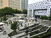
The large concentration of high-technology engineering, computer, and microprocessor companies around San Jose has led the area to be known as Silicon Valley. Area schools such as the University of California, Berkeley, University of California, Santa Cruz, San Jose State University, San Francisco State University, California State University, East Bay, Santa Clara University, and Stanford University pump thousands of engineering and computer science graduates into the local economy every year.
San Jose residents produce more U.S. patents than any other city.[147] On October 15, 2015, the United States Patent and Trademark Office opened a satellite office in San Jose to serve Silicon Valley and the Western United States.[148][149] By April 2018, Google was in the process of planning the "biggest tech campus in Silicon Valley" in San Jose.[150] However, in April 2023, it was reported that Google paused on Google West San Jose Campus constructions due to slowing economic conditions and a decreased requirement for physical office space by tech companies,[151] although the tech ecosystem has also recently become more geographically dispersed.[152]
High economic growth during the tech bubble caused employment, housing prices, and traffic congestion to peak in the late 1990s. As the economy slowed in the early 2000s, employment and traffic congestion was somewhat diminished.[153] In the mid-2000s, traffic along major highways again began to worsen as the economy improved. San Jose had 405,000 jobs within its city limits in 2006, and an unemployment rate of 4.6%. San Jose has the highest median income of any U.S. city with over 280,000 people.
On March 14, 2013, San Jose implemented a public wireless connection in its downtown area. Wireless access points have been placed on outdoor light posts throughout the city.[154]
Media
[edit]San Jose is served by Greater Bay Area media. Print media outlets in San Jose include The Mercury News, the weekly Metro Silicon Valley, El Observador and the Silicon Valley / San Jose Business Journal. The Bay Area's NBC O&O, KNTV 11, is licensed to San Jose. In total, broadcasters in the Bay Area include 34 television stations, 25 AM radio stations, and 55 FM radio stations.[155]
In April 1909, Charles David Herrold, an electronics instructor in San Jose, constructed a radio station to broadcast the human voice. The station, "San Jose Calling" (call letters FN, later FQW), was the world's first radio station with scheduled programming targeted at a general audience.[citation needed] The station became the first to broadcast music in 1910. Herrold's wife Sybil became the first female "disk jockey" in 1912. The station changed hands a number of times before becoming today's[when?] KCBS in San Francisco.[156]
Top employers
[edit]As of June 30, 2023, the top employers in the city were:[157]
| No. | San Jose's Top Employers | Employees |
|---|---|---|
| 1 | County of Santa Clara | 20,000 |
| 2 | City of San Jose | 8,044 |
| 3 | Cisco Systems | 7,500 |
| 4 | Kaiser Permanente | 4,400 |
| 5 | San Jose State University | 4,095 |
| 6 | Adobe Systems, Inc. | 4,000 |
| 7 | Western Digital | 2,891 |
| 8 | Broadcom | 2,805 |
| 9 | PayPal | 2,801 |
| 10 | San Jose Unified School District | 2,516 |
| 11 | ByteDance | 2,500 |
| 12 | Target Stores | 2,437 |
| 13 | eBay | 2,351 |
| 14 | Super Micro Computer, Inc. | 2,219 |
| 15 | IBM | 2,070 |
Culture
[edit]Architecture
[edit]
Because the downtown area is in the flight path to nearby Mineta San Jose International Airport (also evidenced in the above panoramic), there is a height limit for buildings in the downtown area, which is underneath the final approach corridor to the airport. The height limit is dictated by local ordinances, driven by the distance from the runway and a slope defined by Federal Aviation Administration regulations. Core downtown buildings are limited to approximately 300 ft (91 m) but can get taller farther from the airport.[158]
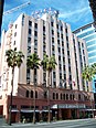
There has been broad criticism over the past few decades of the city's architecture.[159] Citizens have complained that San Jose is lacking in aesthetically pleasing architectural styles. Blame for this lack of architectural "beauty" can be assigned to the re-development of the downtown area from the 1950s onward, in which whole blocks of historic commercial and residential structures were demolished.[160] Exceptions to this include the Downtown Historic District, the Hotel De Anza, and the Hotel Sainte Claire, both of which are listed in the National Register of Historic Places for their architectural and historical significance.

Municipal building projects have experimented more with architectural styles than have most private enterprises.[161] The Children's Discovery Museum, Tech Museum of Innovation, and the San Jose Repertory Theater building have experimented with bold colors and unusual exteriors. The new City Hall, designed by Richard Meier & Partners, opened in 2005 and is a notable addition to the growing collection of municipal building projects.[162]
San Jose has many examples of houses with fine architecture. Late 19th century and early 20th century styles exist in neighborhoods such as Hanchett Park, Naglee Park, Rose Garden, and Willow Glen (including Palm Haven).
Styles include Mediterranean Revival architecture, Spanish Colonial architecture, Neoclassical architecture, Craftsman, Mission Revival, Prairie style, and Queen Anne style Victorian.
Notable architects include Frank Delos Wolfe, Theodore Lenzen, Charles McKenzie,[163] and Julia Morgan.[164]
Visual arts
[edit]
Public art is an evolving attraction in the city. The city was one of the first to adopt a public art ordinance at 2% of capital improvement building project budgets,[165] and as a result of this commitment, a considerable number of public art projects exist in the downtown area, and a growing collection in neighborhoods including libraries, parks, and fire stations. In particular, the Mineta Airport expansion incorporated art and technology into its development. Early public art included a statue of Quetzalcoatl (the plumed serpent) downtown, controversial in its planning because some called it pagan, and controversial in its implementation because many felt that the final statue by Robert Graham did not look like a winged serpent, and was more noted for its expense than its aesthetics. Locals joked that the statue resembles a pile of feces.[166]
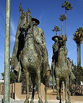
A statue of Thomas Fallon also met strong resistance from those who called him largely responsible for the decimation of early native populations. Chicano/Latino activists protested because he had captured San Jose by military force in the Mexican–American War (1846). They also protested the perceived "repression" of historic documents detailing Fallon's orders expelling many of the city's Californio (early Spanish/Mexican/Mestizo) residents. In October 1991 protests at Columbus Day and Dia de la Raza celebrations stalled than plan, and the statue was stored in a warehouse in Oakland for more than a decade. The statue returned in 2002 to a less conspicuous location: Pellier Park, a small triangular patch at the merge of West Julian and West St. James streets.[167]
In 2001, the city-sponsored SharkByte, an exhibit of decorated sharks based on the mascot of the hockey team, the San Jose Sharks, and modeled after Chicago's display of decorated cows.[168] Large models of sharks decorated in clever, colorful, or creative ways by local artists were displayed for months at dozens of locations around the city. After the exhibition, the sharks were auctioned off for charity.
In 2006, Adobe Systems commissioned an art installation titled San Jose Semaphore by Ben Rubin,[169] at the top of its headquarters building. Semaphore is composed of four LED discs which "rotate" to transmit a message. The content remained a mystery until it was deciphered in August 2007.[170][171] The visual art installation is supplemented with an audio track, transmitted from the building on a low-power AM station. The audio track provides clues to decode the message being transmitted.
San Jose retains a number of murals in the Chicano history tradition of Diego Rivera and José Clemente Orozco of murals as public textbooks.[172]
Although intended to be permanent monuments to the city's heritage as a mission town founded in 1777, a number of murals have been painted over, notably Mural de la Raza, on the side of a Story Rd shoe store, and Mexicatlan at the corner of Sunset and Alum Rock. In addition, two of three murals by Mexican artist Gustavo Bernal Navarro have disappeared.[172] The third mural, La Medicina y la Comunidad at the Gardner clinic on East Virginia Street, depicts both modern and traditional healers.[172]
Surviving Chicano history murals include Nuestra Senora de Guadelupe at Our Lady of Guadalupe church and the 1970s or 1980s Virgen de Guadelupe Huelga Bird at Cal Foods east of downtown. The Guadalajara restaurant has the 1986 Guadalajara Market No. 2 by Edward Earl Tarver III and a 2013 work by Jesus Rodriguez and Empire 7, La Gran Culture Resonance.[172]
An unknown artist painted the Huelga Bird and Aztec City mural in the 1970s or 1980s on the Clyde L. Fisher Middle School. In 1995 Antonio Nava Torres painted The Aztec Calendar Handball Court at Biebrach Park, and the unknown artist of Chaco's Pachuco painted it on the former Chaco's Restaurant in the 1990s. The Jerry Hernandez mural by Frank Torres at Pop's Mini Mart on King Road dates to 2009, and another recent mural by Carlos Rodriguez on the Sidhu Market at Locust and West Virginia depicts a stern-looking warrior.[172]
Performing arts
[edit]
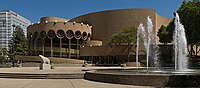
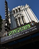
The city is home to many performing arts companies, including Opera San Jose, Symphony Silicon Valley, Ballet San Jose Silicon Valley, sjDANCEco, The San Jose Symphonic Choir, Children's Musical Theater San Jose,[173] the San Jose Youth Symphony, the San Jose Repertory Theatre, City Lights Theatre Company, The Tabard Theatre Company, San Jose Stage Company, and the now-defunct American Musical Theatre of San Jose which was replaced by Broadway San Jose in partnership with Team San Jose. San Jose is also home to the San Jose Museum of Art,[174] one of the nation's premiere Modern Art museums.
The SAP Center at San Jose is one of the most active venues for events in the world. According to Billboard Magazine and Pollstar, the arena sold the most tickets to non-sporting events of any venue in the United States, and third in the world after the Manchester Evening News Arena in Manchester, England, and the Bell Centre in Montreal, Canada, for the period from January 1 – September 30, 2004.[175]
The annual Cinequest Film Festival in downtown has grown to over 60,000 attendees per year, becoming an important festival for independent films. The San Francisco Asian American Film Festival is an annual event, which is hosted in San Francisco, Berkeley, and Downtown San Jose. Approximately 30 to 40 films are screened in San Jose each year at the Camera 12 Downtown Cinemas. The San Jose Jazz Festival is another of many events hosted throughout the year.
The Ira F. Brilliant Center for Beethoven Studies houses the largest collection of Ludwig van Beethoven in the world, outside of Europe, and is the only institution of its kind in North America.
Sports
[edit]

| Club | Sport | Founded | League | Venue (capacity) |
|---|---|---|---|---|
| San Jose Sharks | Hockey | 1991 | National Hockey League | SAP Center (17,562) |
| San Jose Earthquakes | Soccer | 1995 | Major League Soccer | PayPal Park (18,000) |
| San Jose Barracuda | Hockey | 2015 | American Hockey League | Tech CU Arena (4,200) |
| San Jose Giants | Baseball | 1988 | California League | Excite Ballpark (4,200) |
| San Jose State Spartans | NCAA Football | 1893 | Mountain West Conference | CEFCU Stadium (21,520) |
San Jose is home to the San Jose Sharks of the NHL, the San Jose Barracuda of the AHL, and the San Jose Earthquakes of Major League Soccer. The Sharks and the Barracuda play in the SAP Center at San Jose. The Earthquakes built an 18,000 seat new stadium that opened in March 2015. San Jose was a founding member of both the California League and Pacific Coast League in minor league baseball. San Jose currently fields the San Jose Giants, a Low-A affiliate of the San Francisco Giants.
San Jose has been host to several U.S. Olympic team trials over the years. In 2004, the San Jose Sports Authority held the trials for judo, taekwondo, trampolining and rhythmic gymnastics at the San Jose State Event Center. SAP Center hosted the Gymnastic trials in 2012[176] and 2016 (women's only).[177] and the U.S. Figure Skating Championships (used in Olympic years to select the Olympians) in 1996, 2012, and 2018. It was due to host the 2021 Championship, but that was moved to Las Vegas and it will instead host 2023.[178] In 2008, around 90 percent of the members of the United States Olympic team were processed at San Jose State University prior to traveling to the 2008 Summer Olympics in Beijing.[179] The 2009 Junior Olympics for trampoline were also held here.
In August 2004, the San Jose Seahawk Rugby Football Club hosted the USA All-Star Rugby Sevens Championships at Watson Bowl, east of Downtown. San Jose State hosted the 2011 American Collegiate Hockey Association (ACHA) national tournament.[180] The NCAA Division I men's basketball tournament is also frequently held in San Jose.
From 2005 to 2007, the San Jose Grand Prix, an annual street circuit race in the Champ Car World Series, was held in the downtown area. Other races included the Trans-Am Series, the Toyota Atlantic Championship, the United States Touring Car Championship, the Historic Stock Car Racing Series, and the Formula D Drift racing competition.
In the 2010s, San Jose "aggressively wooed" the Oakland Athletics to relocate to San Jose from nearby Oakland, but the San Francisco Giants exercised a veto against this proposal.[181] In 2013, the city of San Jose sued Major League Baseball for not allowing the Athletics to relocate to San Jose.[182] On October 5, 2015, the United States Supreme Court rejected San Jose's bid on the Athletics, who in 2023 announced they would relocate to Las Vegas.[183]
Landmarks
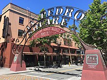
[edit]Notable landmarks in San Jose include Children's Discovery Museum of San Jose, History Park at Kelley Park, Cathedral Basilica of St. Joseph, Plaza de César Chávez, Dr. Martin Luther King, Jr. Library, Mexican Heritage Plaza, Rosicrucian Egyptian Museum, Lick Observatory, Hayes Mansion, SAP Center at San Jose, Hotel De Anza, San Jose Improv, Sikh Gurdwara of San Jose, Peralta Adobe, Excite Ballpark, Spartan Stadium, Japantown San Jose, Winchester Mystery House, Raging Waters, Circle of Palms Plaza, San Jose City Hall, San Jose Flea Market, Oak Hill Memorial Park, San Jose electric light tower, and The Tech Museum of Innovation.
-

-

-

-
-
-

-
-

-

-

-
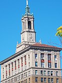
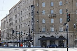 The historic Sainte Claire Hotel, today The Westin San Jose
 -


Museums and institutions
[edit]

- The Tech Museum of Innovation
- Ira F. Brilliant Center for Beethoven Studies, which houses the largest collection of Ludwig van Beethoven in the world outside of Europe
- Dr. Martin Luther King, Jr. Library, the largest U.S. public library west of the Mississippi River
- San Jose Museum of Art, contemporary art museum with a collection of West Coast artists
- Children's Discovery Museum of San Jose
- History Park at Kelley Park
- Mexican Heritage Plaza, a Chicano museum and cultural center
- Movimiento de Arte y Cultura Latino Americana, is an inclusive contemporary arts museum grounded in the Chicano/Latino experience
- Portuguese Historical Museum
- Rosicrucian Egyptian Museum, the largest collection of Egyptian artifacts on display in the western United States, located at Rosicrucian Park
- San Jose East Carnegie Branch Library is notable as it is the last Carnegie library still operating in San Jose, and is on the National Register of Historic Places.
- San Jose Steam Railroad Museum, proposed, artifacts and rolling stock are kept at the fairgrounds and Kelley Park
- History San José
- Japanese American Museum of San Jose, a museum of Japanese-American history
- Old Bank of America Building, a historic landmark
- San Jose Museum of Quilts & Textiles, the first museum in America dedicated solely to quilts and textiles as an art form
- Viet Museum, a museum of Vietnamese-American history
Law and government
[edit]
Local
[edit]San Jose is a charter city under California law, giving it the power to enact local ordinances that may conflict with state law, within the limits provided by the charter.[184] The city has a council-manager government with a city manager nominated by the mayor and elected by the city council.
The San Jose City Council is made up of ten council members elected by district, and a mayor elected by the entire city. During city council meetings, the mayor presides, and all eleven members can vote on any issue. The mayor has no veto powers. Council members and the mayor are elected to four-year terms; the even-numbered district council members beginning in 1994; the mayor and the odd-numbered district council members beginning in 1996.[185] Each council member represents approximately 100,000 constituents.
Council members and the mayor are limited to two successive terms in office, although a council member that has reached the term limit can be elected mayor, and vice versa. The council elects a vice-mayor from the members of the council at the second meeting of the year following a council election. This council member acts as mayor during the temporary absence of the mayor, but does not succeed to the mayor's office upon a vacancy.[185]

The City Manager is the chief administrative officer of the city, and must present an annual budget for approval by the city council. When the office is vacant, the Mayor proposes a candidate for City Manager, subject to council approval. The council appoints the Manager for an indefinite term, and may at any time remove the manager, or the electorate may remove the manager through a recall election. Other city officers directly appointed by the council include the City Attorney, City Auditor, City Clerk, and Independent Police Auditor.[185] Like all cities and counties in the state, San Jose has representation in the state legislature.
Like all California cities except San Francisco, both the levels and the boundaries of what the city government controls are determined by the Local Agency Formation Commission (LAFCO).[186] The goal of a LAFCO is to try to avoid uncontrolled urban sprawl. The Santa Clara County LAFCO has set boundaries of San Jose's "Sphere of Influence" (indicated by the blue line in the map near the top of the page) as a superset of the actual city limits (the yellow area in the map), plus parts of the surrounding unincorporated county land, where San Jose can, for example, prevent development of fringe areas to concentrate city growth closer to the city's core. The LAFCO also defines a subset of the Sphere as an 'Urban Service Area' (indicated by the red line in the map), effectively limiting development to areas where urban infrastructure (sewers, electrical service, etc.) already exists.
San Jose is the county seat of Santa Clara County.[187] Accordingly, many county government facilities are located in the city, including the office of the County Executive, the Board of Supervisors, the District Attorney's Office, eight courthouses of the Superior Court, the Sheriff's Office, and the County Clerk.[188]
San Jose is protected by the San Jose Police Department and San Jose Fire Department. Drinking water is supplied by the San José Municipal Water System (Muni Water) along with the privately owned San Jose Water Company and Great Oaks Water Company. The San José–Santa Clara Regional Wastewater Facility provides advanced wastewater treatment and reclaimed water.
State and federal
[edit]
In the California State Senate, San Jose is split between the 10th, 15th, and 17th districts,[13] represented by Democrat Aisha Wahab, Democrat Dave Cortese, and Democrat John Laird respectively.
In the California State Assembly, San Jose is split between the 23rd, 24th, 25th, 26th, and 28th districts,[5] represented by Democrat Marc Berman, Democrat Alex Lee, Democrat Ash Kalra, Democrat Evan Low, and Democrat Gail Pellerin, respectively.
Federally, San Jose is split between California's 17th, 18th, and 19th congressional districts,[189] represented by Democrat Ro Khanna, Democrat Zoe Lofgren, and Democrat Jimmy Panetta, respectively.[190]
Several state and federal agencies maintain offices in San Jose. The city is the location of the Sixth District of the California Courts of Appeal.[191] It is also home to one of three courthouses of the United States District Court for the Northern District of California, the other two being in Oakland and San Francisco.[192]
Crime
[edit]Like most large cities, crime levels had fallen significantly after rising in the 1980s.[193] From 2002 to 2006, Morgan Quitno Press named San Jose the safest city in the United States with a population over 500,000 people.[194] Crime in San Jose had been lower than in other large American cities until 2013, when crime rates in San Jose climbed above California and U.S. averages.[195]
In 2021, SmartAsset ranked San Jose tied as the 10th safest city in the United States.[196] In 2020, violent crime per 100,000 people has been the lowest the city has seen in 2017 while the homicide rate has been the highest since 2016; property crime per 100,000 people has been the lowest the city has seen in over ten years.[197]
- 2021 mass shooting
On May 26, 2021, a mass shooting occurred at a Santa Clara Valley Transportation Authority (VTA) rail yard in San Jose. Ten people were killed, including the gunman, 57-year-old VTA employee Samuel James Cassidy, who shot and killed himself.[198][199][200][201] The shooting led to a day-long suspension of light rail services in the area.[202][203] It is the deadliest mass shooting in the history of the San Francisco Bay Area.[204]
In June 2021, roughly a month following the shooting, San Jose became the first city in the United States to require gun owners to carry liability insurance after a unanimous vote by the city council.[205]
Education
[edit]Higher education
[edit]


San Jose is home to several colleges and universities. The largest is San José State University, which was founded by the California legislature in 1862 as the California State Normal School, and is the founding campus of the California State University (CSU) system. Located in downtown San Jose since 1870, the university enrolls approximately 35,000 students in over 250 different bachelor's, master's and doctoral degree programs.[206]
The school enjoys a good academic reputation, especially in the fields of engineering, business, computer science, art and design, and journalism, and consistently ranks among the top public universities in the western region of the United States.[207] San Jose State is one of only three Bay Area schools that fields a Football Bowl Subdivision (FBS) Division I college football team; Stanford University and U.C. Berkeley are the other two.
California University of Management and Technology (CALMAT) offers many degree programs, including MBA, Computer Science, Information Technology. Most classes are offered both online and in the downtown campus. Many of the students are working professionals in the Silicon Valley.
The University of Silicon Valley is located in the Golden Triangle of North San Jose.
Lincoln Law School of San Jose and University of Silicon Valley Law School offer law degrees, catering to working professionals.
National University maintains a campus in San Jose.
The San Jose campus of Golden Gate University offers business bachelor and MBA degrees.
In the San Jose metropolitan area, Stanford University is in Stanford, California, Santa Clara University is in Santa Clara, California, and U.C. Santa Cruz is in Santa Cruz, California. Within the San Francisco Bay Area, other universities include U.C. Berkeley, U.C. San Francisco, U.C. Hastings College of Law, University of San Francisco, and California State University, East Bay.
The San Jose area's community colleges, San Jose City College, West Valley College, Mission College and Evergreen Valley College, offer associate degrees, general education units to transfer to CSU and UC schools, and adult and continuing education programs. The West campus of Palmer College of Chiropractic is also located in San Jose.
WestMed College is headquartered in San Jose and offers paramedic training, emergency medical technician training, and licensed vocational nursing programs.
The University of California operates Lick Observatory atop Mount Hamilton.
Western Seminary has one of its four campuses in San Jose, which opened on the campus of Calvary Church of Los Gatos in 1985. The campus relocated in 2010 to Santa Clara. Western is an evangelical, Christian graduate school that provides theological training for students who hope to serve in a variety of ministry roles including pastors, marriage and family therapists, educators, missionaries and lay leadership. The San Jose campus offers four master's degrees, and a variety of other graduate-level programs.[208]
National Hispanic University offered associate and bachelor's degrees and teaching credentials to its students, focusing on Hispanic students, until its closing in 2015.[209]
Primary and secondary education
[edit]Until the opening of Lincoln High School in 1943, San Jose students only attended San Jose High School. San Jose has 127 elementary, 47 middle, and 44 public high schools.
Public education in the city is provided by four high school districts, fourteen elementary districts, and three unified school districts (which provide both elementary and high schools).[210]
- Unified school districts include: San Jose USD (SJUSD), Morgan Hill USD, and Santa Clara USD
- Secondary school districts include: Campbell UHSD, East Side UHSD, Fremont UHSD, and Los Gatos-Saratoga JUSD
- Elementary school districts include: Alum Rock UESD, Berryessa UESD, Cambrian ESD, Campbell UESD, Cupertino UESD, Evergreen ESD, Franklin-McKinley ESD, Los Gatos UESD, Luther Burbank ESD, Moreland SD, Mount Pleasant ESD, Oak Grove ESD, Orchard ESD, and Union ESD.
SJUSD declared bankruptcy in 1983; at that time, it was the largest US school district to declare bankruptcy.[211] Observers identified the reasons as a drop of 5,000 students in the preceding years, the difficulties imposed on school finances by Serrano v. Priest in 1968, the reduction of tax monies because of 1978 California Proposition 13, and the local teacher's union contract requiring a raise in pay.[212]
Private schools in San Jose are primarily run by religious groups.[citation needed] The Catholic Diocese of San Jose has the second-largest student population in Santa Clara County, behind only SJUSD;[citation needed] the diocese and its parishes operate several schools in the city, including five high schools.[213] Other private religious schools are Baptist,[214] non-denominational Protestant, and Wisconsin Synod Lutheran.[215] Secular private schools include Cambrian Academy and Harker School.
Libraries
[edit]
The San José Public Library system is unique in that the Dr. Martin Luther King Jr. Library combines the collections of the city's system with the San Jose State University main library. In 2003, construction of the library, which now holds more than 1.6 million items, was the largest single library construction project west of the Mississippi, with eight floors that result in more than 475,000 sq ft (44,100 m2) of space with a capacity for 2 million volumes.[216]
The city has 23 neighborhood branches including the Biblioteca Latinoamericana ('Latin American Library') which specializes in Spanish language works.[217] The East San Jose Carnegie Branch Library, a Carnegie library opened in 1908, is the last Carnegie library in Santa Clara County still operating as a public library and is listed in the National Register of Historic Places. As the result of a bond measure passed in November 2000, a number of brand new or completely reconstructed branches have been completed and opened. The yet-to-be-named brand new Southeast Branch is also planned, bringing the bond library project to its completion.[218]
The San Jose system (along with the university system) were jointly named as "Library of the Year" by Library Journal in 2004.[219]
Transportation
[edit]Like other American cities built mostly after World War II, San Jose is highly automobile-dependent, with 76 percent of residents driving alone to work and 12 percent carpooling in 2017.[220] The city set an ambitious goal to shift motorized trips to walking, bicycling, and public transit in 2009 with the adoption of its Envision San Jose 2040 General Plan. In 2018, the city extended these goals to 2050 with its San Jose Climate Smart plan.[221]
Public transit
[edit]
Rail service to and from San Jose is provided by Amtrak (the Sacramento–San-Jose Capitol Corridor and the Seattle–Los-Angeles Coast Starlight), Caltrain (commuter rail service between San Francisco and Gilroy), ACE (commuter rail service to Pleasanton and Stockton), and the local VTA light rail system connecting downtown to Mountain View, Milpitas, Campbell, and Almaden Valley, operated by the Santa Clara Valley Transportation Authority (VTA). Historic streetcars from History Park operate on the light rail lines in downtown during holidays.
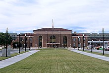
Long-term plans call for BART to be expanded to Santa Clara from the Berryessa/North San José station. Originally, the extension was to be built all at once, but due to the recession, sales tax revenue has dramatically decreased. Because of this, the extension will be built in two phases. Phase 1 extended service to San Jose with the completion of the Milpitas and Berryessa BART stations on June 13, 2020. In addition, San Jose will be a major stop on the future California High-Speed Rail route between Los Angeles and San Francisco.[222] Diridon Station (formerly Cahill Depot, 65 Cahill Street) is the meeting point of all regional commuter rail service in the area.[223] It was built in 1935 by the Southern Pacific Railroad, and was refurbished in 1994.
VTA also operates many bus routes in San Jose and the surrounding communities, as well as offering paratransit services to local residents. Additionally, the Highway 17 Express bus line connects central San Jose with Santa Cruz. Intercity bus providers include Greyhound, BoltBus, Megabus, California Shuttle Bus, TUFESA, Intercalifornias, Hoang, and USAsia.[224] FlixBus also services the city with a stop at 129 W San Carlos.
Air
[edit]
San Jose is served by Norman Y. Mineta San Jose International Airport two mi (3.2 km) northwest of downtown, and by Reid-Hillview Airport of Santa Clara County, general aviation airport located in the eastern part of San Jose. San Jose residents also use San Francisco International Airport, a major international hub located 35 mi (56 km) to the northwest, and San Francisco Bay Oakland International Airport, another major international airport located 35 mi (56 km) to the north. The airport is also near the intersections of three major freeways, US 101, I-880, and SR 87.
Highways
[edit]The San Jose area is served by a freeway system that includes three Interstate freeways and one U.S. Route. It is, however, the largest city in the country not served by a primary (one- or two-digit route number) Interstate; most of the Interstate Highway Network was planned by the early 1950s well before San Jose's rapid growth decades later.
US 101 runs south to the California Central Coast and Los Angeles, and then runs north up near the eastern shore of the San Francisco Peninsula to San Francisco. I-280 also heads to San Francisco, but goes along just to the west of the cities of the San Francisco Peninsula. I-880 heads north to Oakland, running parallel to the southeastern shore of San Francisco Bay. I-680 parallels I-880 to Fremont, but then cuts northeast to the eastern cities of the San Francisco Bay Area.

Several state highways also serve San Jose: SR 17, SR 85, SR 87 and SR 237. Additionally, San Jose is served by a system of county-wide expressways, which includes the Almaden Expressway, Capitol Expressway, San Tomas Expressway, and Lawrence Expressway.
Several regional transportation projects have been undertaken in recent years to manage congestion on San Jose freeways. This includes expanding State Route 87 to add more lanes near the downtown San Jose area.
The interchange for I-280 connecting with I-680 and U.S. 101 was named the Joe Colla Interchange.[226]
Major highways:
Bicycling
[edit]Central San Jose has seen a gradual expansion of bike lanes over the past decade, which now comprise a network of car-traffic-separated and buffered bike lanes. San Jose Bike Party is a volunteer-run monthly social cycling event that attracts up to 1,000 participants during summer months to "build community through bicycling". Fewer than one percent of city residents ride bicycles to work[227] as their primary mode of transportation, a statistic unchanged in the past ten years. Typically, between 3 and 5 residents are struck and killed by car drivers while bicycling on San Jose streets each year.[228]
Notable people
[edit]Sister cities
[edit]San Jose has one of the oldest Sister City programs in the nation. In 1957, when the city established a relationship with Okayama, Japan, it was only the third Sister City relationship in the nation, which had begun the prior year. The Office of Economic Development coordinates the San Jose Sister City Program which is part of Sister Cities International. As of 2014[update], there are eight sister cities:[229][230]
- Okayama, Japan (established on May 26, 1957)[231]
- San José, Costa Rica (1961)
- Veracruz, Mexico (1975)
- Tainan, Taiwan (1977)
- Dublin, Ireland (1986)[232]
- Yekaterinburg, Russia (1992)
- Pune, India (1992)
- Guadalajara, Mexico (2014)[233][234]
See also
[edit]References
[edit]- ^ "California Cities by Incorporation Date". California Association of Local Agency Formation Commissions. Archived from the original (Word) on November 3, 2014. Retrieved August 25, 2014.
- ^ "Government". San Jose, California. Archived from the original on March 15, 2015. Retrieved March 15, 2015.
- ^ "City Council". San Jose, California. Archived from the original on December 16, 2014. Retrieved December 8, 2014.
- ^ "San Jose, California's City Council appointed Jennifer Maguire interim City Manager". July 13, 2021. 13, 2021 Archived from the original on August 24, 2021. Retrieved August 24, 2021.
{{cite news}}: Check|archive-url=value (help) - ^ Jump up to: a b "Communities of Interest – City". California Citizens Redistricting Commission. Archived from the original on October 23, 2015. Retrieved October 10, 2014.
- ^ "2019 U.S. Gazetteer Files". United States Census Bureau. Archived from the original on August 26, 2022. Retrieved July 1, 2020.
- ^ "San Jose". Geographic Names Information System. United States Geological Survey, United States Department of the Interior. Retrieved January 11, 2015.
- ^ Jump up to: a b "Elevations and Distances". US Geological Survey. April 29, 2005. Archived from the original on November 9, 2013. Retrieved February 10, 2015.
- ^ Jump up to: a b c d "QuickFacts: San Jose city, California". United States Census Bureau.
- ^ "2020 Population and Housing State Data". Census.gov. United States Census Bureau. Archived from the original on August 24, 2021. Retrieved August 22, 2021.
- ^ "ZIP Code(tm) Lookup". United States Postal Service. Archived from the original on November 16, 2014. Retrieved November 23, 2014.
- ^ "San Jose City Manager Norberto Duenas Has Interim Tag Removed". San Jose Inside. Metro Newspapers. May 5, 2015. Archived from the original on May 7, 2015. Retrieved May 5, 2015.
- ^ Jump up to: a b "Communities of Interest – City". California Citizens Redistricting Commission. Archived from the original on October 23, 2015. Retrieved October 10, 2014.
- ^ Jump up to: a b City Charter, Adopted in 1965 and as Amended by Voters through February 2021. City of San José. February 2021 [1965]. section 100. Archived from the original on August 11, 2021. Retrieved September 6, 2021.
- ^ In isolation, San is pronounced Spanish pronunciation: [san].
- ^ Jones Thompson, Maryann (March 31, 2023). "It's Official: A Quarter Million People Fled the Bay Area Since 2020". The San Francisco Standard. Retrieved December 18, 2023.
- ^ "Metropolitan and Micropolitan Statistical Areas Population Totals: 2020-2022". Census.gov. Retrieved December 18, 2023.
- ^ Jump up to: a b "U.S. Census website". U.S. Census Bureau. Archived from the original on August 7, 2022. Retrieved December 3, 2019.
- ^ Blair Rowan, Harriet; Greschler, Gabriel; Prodis Sulek, Julia (May 18, 2023). "San Jose no longer in Top 10 of most populous U.S. cities". The Mercury News. Retrieved May 20, 2023.
- ^ "Annual Estimates of the Resident Population: April 1, 2010 to July 1, 2018". United States Census Bureau, Population Division. April 2019. Archived from the original on February 13, 2020. Retrieved May 30, 2019.
- ^
- "New study: San Jose is more diverse than San Francisco". March 6, 2019. Archived from the original on January 24, 2022. Retrieved March 25, 2022.
- "Three Bay Area cities considered most diverse in the U.S." October 14, 2019. Archived from the original on March 25, 2022. Retrieved March 25, 2022.
- "San Jose Makes Another List, Included in 2018's Top 10 Most Diverse Cities". www.sjchamber.com. Archived from the original on April 7, 2023. Retrieved March 25, 2022.
- ^
- Zeveloff, J. (February 14, 2013). "The 10 Most Expensive Cities in the United States" Archived May 7, 2016, at the Wayback Machine Daily Finance. Retrieved August 16, 2013
- Hsu, T. (September 20, 2012). "America's richest cities: Census say San Jose, San Francisco" . Los Angeles Times. Retrieved August 16, 2013.
- Glink, I. (February 22, 2013). "America's Richest Cities in 2013." Archived March 8, 2017, at the Wayback Machine. Yahoo Finance. Retrieved August 16, 2013
- Bass, F., Homan, T. (October 18, 2011). "Beltway Earnings Make US Capital Richer Than Silicon Valley" Archived July 29, 2014, at the Wayback Machine. Bloomberg. Retrieved August 16, 2013.
- ^ Kettmann, Steve (November 4, 2005). "36 Hours in San Jose, Calif". The New York Times. Archived from the original on March 26, 2022. Retrieved March 26, 2022.
- ^ "Where is Silicon Valley?". Silicon Valley Historical Association. Archived from the original on July 4, 2020. Retrieved March 8, 2021.
- ^
- Jenkins, A. Jarrod (April 19, 2019). "Jenkins: It's time to drop the 'Capital of Silicon Valley' slogan". San Jose Spotlight. Archived from the original on September 11, 2021. Retrieved September 10, 2021.
- "Where is Silicon Valley?". Silicon Valley Historical Association. Archived from the original on July 4, 2020. Retrieved March 8, 2021.
- ^ "Silicon Valley Business Journal – San Jose Area has World's Third-Highest GDP Per Capita, Brookings Says". Archived from the original on March 9, 2017. Retrieved March 8, 2017.
- ^ Millington, Alison. "The 10 most expensive cities to live in around the world in 2017". Business Insider. Archived from the original on March 26, 2022. Retrieved March 26, 2022.
- ^ Nguyen, Beth (August 17, 2016). "Preserving Vietnamese Tradition in Silicon Valley". Museum of Food and Drink. Archived from the original on January 22, 2022. Retrieved April 20, 2022.
- ^ Gary, Jesse (September 20, 2021). "Combatting a decades-old Silicon Valley problem: Inclusivity amongst Hispanic populations". KTVU FOX 2. Archived from the original on March 26, 2022. Retrieved March 26, 2022.
- ^ "The First City". California History Online. Archived from the original on February 18, 2008. Retrieved March 15, 2008.
- ^ "California Admission Day—September 9, 1850". California State Parks. 2007. Archived from the original on March 28, 2016. Retrieved March 15, 2008.
- ^ Jump up to: a b "1990 and 1980 Census Counts for Cities with 1990 Population Greater Than 100,000". United States Census Bureau. Archived from the original on June 29, 2014. Retrieved August 8, 2014.
1980: San Francisco = 678974, San Jose = 629400. 1990: San Jose = 782248, San Francisco = 723959
- ^ McDermid, Riley (September 26, 2017). "San Jose has the Fastest-Growing Economy in California". Silicon Valley Business Journal. Archived from the original on August 19, 2018. Retrieved September 27, 2017.
- ^ Li, Roland; Rezal, Adriana (May 17, 2023). "This Bay Area city is no longer one of 10 biggest in U.S. — booted by cities in Florida and Texas". San Francisco Chronicle.
- ^ Gray, W. Vallance; Gifford, C. (1869). Bird's eye view of the city of San José, Cal (Map). San Jose, California: George H. Hare – via Wikimedia Commons.
- ^ Monro-Fraser, J. P., ed. (August 1881). History of Santa Clara County, California. Alley, Bowen & Company. p. 344. Archived from the original on April 23, 2023. Retrieved September 7, 2021 – via Google Books.
On Saturday, December 15, 1849, the first Legislature of the State met in San José.
- ^ "Decision 44-136". Washington, D.C.: United States Board on Geographic Names. December 11, 1943. Archived from the original on August 29, 2021. Retrieved August 28, 2021.
- ^ Purcell, John M.; Croft, James A.; Monahan, Rich. American City Flags (PDF). North American Vexillological Association. pp. 320–321. Archived (PDF) from the original on August 29, 2021. Retrieved May 1, 2020.
- ^ "S70-12 Acute Accent (é) Placed on the 'E' of San Jose in All Written Communication" (PDF). San Jose State College. June 16, 1970. Archived (PDF) from the original on September 24, 2021. Retrieved August 28, 2021.
- ^ "An Accent Mark". Napa, California: Napa Valley Register. United Press International. August 21, 1974. p. 17. Archived from the original on April 23, 2023. Retrieved August 29, 2021 – via Newspapers.com.
- ^ Jones, Jimmie (August 23, 1974). "San Jose Council Orders An Accent". Vallejo Times Herald. p. 6. Archived from the original on April 23, 2023. Retrieved August 29, 2021 – via Newspapers.com.
- ^ "Salute reversed". The Courier-Journal. Louisville, Kentucky. Associated Press. August 30, 1974. p. A6. Archived from the original on April 23, 2023. Retrieved August 29, 2021 – via Newspapers.com.
- ^ City of San Jose – Memorandum, Use of the Official City Seal and the Bicentennial Logo, April 5, 1979 (on file at the San Jose City Clerk's Office)
- ^ City Charter: In Effect May 4, 1965, as Amended. City of San Jose. 1964. p. 1. Archived from the original on April 23, 2023. Retrieved September 6, 2021 – via Google Books.
- ^ "City Charter in effect May, 1965, amended through February 1, 2010". City of San Jose. February 1, 2010 [1965]. section 100. Archived from the original on September 6, 2021. Retrieved September 6, 2021.
- ^ City of San José Style Guide. City of San José. July 2000. p. 21. Archived from the original (PDF) on February 3, 2017. Retrieved February 5, 2017.
- ^ "Council Memo Format Guidelines" (PDF). San José Public Works Department. August 2016. p. 15. Archived from the original (PDF) on December 29, 2016. Retrieved February 5, 2017.
- ^ "San Jose CA, Official website". Archived from the original on July 23, 2010. Retrieved February 6, 2014.
- ^ For origin, arrival and displacement based on "linguistic evidence" in 500 CE per Levy, 1978:486, also Bean, 1994:xxi (cites Levy 1978). For Shell Mound dating, F.M. Stanger 1968:4.
- ^ Jump up to: a b "Early History". National Register of Historic Places. Archived from the original on June 9, 2007. Retrieved June 5, 2007.
- ^ "Pre-History". November 4, 2013. Archived from the original on November 22, 2017. Retrieved November 23, 2017.
- ^ For events of 1795–1796, Milliken, 1995:129–134 ("Mass Migration in Winter of 1794–95"). For runaways, Milliken, 1995:97 (cites Fages, 1971).
- ^ "Junípero Serra". California History Online. California Historical Society. 2000. Archived from the original on August 12, 2004. Retrieved June 20, 2007.
- ^ Edward F. O'Day (October 1926). "The Founding of San Francisco". San Francisco Water. Spring Valley Water Authority. Archived from the original on July 27, 2010. Retrieved February 7, 2013.
- ^ Clyde Arbuckle (1986). Clyde Arbuckle's History of San Jose. Smith McKay Printing. ISBN 978-9996625220.
- ^ "Spanish Period". San Jose History. Archived from the original on December 1, 2017. Retrieved November 23, 2017.
- ^ "Spanish-Mexican Records of the San José Pueblo: The Pueblo Papers". History San Jose. Archived from the original on December 1, 2017. Retrieved November 23, 2017.
- ^ "Mexican Period". San Jose History. Archived from the original on December 1, 2017. Retrieved November 23, 2017.
- ^ "1846–1869". San Jose History. Archived from the original on November 22, 2017. Retrieved November 23, 2017.
- ^ Maass, Harold (July 14, 1990). "San Jose's Latinos Howl About Plans for a 'Conquest Statue'". Los Angeles Times. Archived from the original on May 11, 2021. Retrieved October 1, 2020.
- ^ "Early History". U.S. National Park Service. February 22, 2018. Archived from the original on November 29, 2020. Retrieved October 1, 2020.
- ^ "California State Capitol History: Part 1". California Capitol Museum. Archived from the original on November 16, 2017. Retrieved November 23, 2017.
- ^ Clyde Arbuckle's History of San Jose (Smith & McKay, 1985), p. 27: "Therefore, unless posterity can determine the order in which the Governor signed these bills, there will always be a question as to whether San Jose, already preceded by Sacramento, was California's second, third, or fourth incorporated city."
- ^ George R. Stewart, The California Trail: An Epic with Many Heroes (University of Nebraska Press, 1962), p. 28.
- ^ Ken McKowen & Dahlynn McKowen, Best of California's Missions, Mansions, and Museums (Wilderness Press, 2006), pp. 77–99.
- ^ First State Capitol Building Archived December 1, 2017, at the Wayback Machine, Historical Marker Database.
- ^ "Our Legacy – JBT". Jbtcorporation.com. Archived from the original on June 5, 2016. Retrieved May 15, 2019.
- ^ "Agnews Insane Asylum". National Register of Historic Places. Archived from the original on May 24, 2007. Retrieved June 7, 2007.
- ^ Jump up to: a b c d e "California – Race and Hispanic Origin for Selected Cities and Other Places: Earliest Census to 1990". U.S. Census Bureau. Archived from the original on August 12, 2012. Retrieved April 20, 2012.
- ^ "PACKING IT IN: SAN JOSE'S FINAL HARVEST VESTIGE OF VALLEY'S AGRICULTURAL BUTT IS LEAVING". The Mercury News. July 25, 1999. Archived from the original on May 24, 2017. Retrieved May 16, 2017.
- ^ Jump up to: a b "Flashback: A short political history of San Jose". San Jose State University. Archived from the original on July 7, 2008. Retrieved November 9, 2013.
- ^ "BAE Systems History". Archived from the original on February 20, 2007. Retrieved November 9, 2013.
- ^ Blankenship, William D. (1971). "Reynold B. Johnson". IBM. Archived from the original on May 4, 2019. Retrieved September 8, 2021.
- ^ Winslow, Ward (editor); The Making of Silicon Valley: a One Hundred Year Renaissance; 1995; ISBN 0-9649217-0-7
- ^ "San Jose case study, part one: the urban-growth boundary". Thoreau Institute. Archived from the original on February 23, 2007. Retrieved June 7, 2007.
- ^ "Building Permit History, 1980–2006". City of San Jose. Archived from the original on September 27, 2007. Retrieved June 7, 2007.
- ^ R. E. Holdsworth; Strachan, R. A.; Magloughlin, J.; Knipe, R. J. (2001). The Nature and Tectonic Significance of Fault Zone Weakening. Geological Society of London. p. 15. ISBN 978-1-86239-090-4. Archived from the original on April 23, 2023. Retrieved November 20, 2020.
- ^ Jump up to: a b Safford, Pat (November 17, 2010). "The legacy of Dutch Hamann plagues Cambrian residents, Annexation Background" (PDF). Campbell Express. Vol. 59, no. 45. p. 1. Archived (PDF) from the original on November 10, 2013. Retrieved November 9, 2013.
- ^ Don Mccormack (July 16, 1995). "San Jose: Reality, not reputation". SFGate. Archived from the original on November 10, 2013. Retrieved July 8, 2013.
- ^ Sachs, Aaron (January–February 1999). "Virtual Ecology – A Brief Environmental History of Silicon Valley" (PDF). World-Watch. Worldwatch.org. p. 15. Archived (PDF) from the original on November 10, 2013. Retrieved November 9, 2013.
- ^ "Dutch Hamann – Part One". San Jose Inside. January 16, 2006. Archived from the original on November 10, 2013. Retrieved July 8, 2013.
- ^ "Dutch Hamann – Part Two". San Jose Inside. January 16, 2006. Archived from the original on November 10, 2013. Retrieved July 8, 2013.
- ^ David Crimp; Leda Patmore; C. Michael Hogan; Harry Seidman; Vivian Paparigian (1976). Final Environmental Impact Report, Almaden Quicksilver Park. Santa Clara County Parks and Recreation Department (Report).
- ^ "Sinking State". San Francisco State University. April 1996. Archived from the original on April 15, 2012. Retrieved November 9, 2013.
- ^ Eastern Region Geography, Information Services (April 29, 2005). "Elevations and Distances". Egsc.usgs.gov. Archived from the original on November 9, 2013. Retrieved October 21, 2014.
- ^ San Jose City Council (March 1, 1983). "Outdoor lighting on private developments" (PDF). Archived from the original (PDF) on July 2, 2006. Retrieved June 18, 2007.
- ^ "UCSC, Lick Observatory designate asteroid for the city of San Jose". University of California, Santa Cruz. May 25, 1998. Archived from the original on August 17, 2007. Retrieved June 18, 2007.
- ^ Julie Phillips; Ryan Phillips; Neela Srinivasan; Deborah Aso; Wendy Lao; Pat Cornely (2012). Safe Passage for Coyote Valley: A Wildlife Linkage for the 101 Corridor (PDF) (Report). Cupertino, California: De Anza College. Archived from the original (PDF) on September 27, 2013. Retrieved January 26, 2019.
- ^ [1] Archived May 3, 2022, at the Wayback Machine "Anderson Reservoir will close to public through 2030". Accessed March 30, 2022.
- ^ [2] Archived May 3, 2022, at the Wayback Machine "Anderson Reservoir drained to 3 percent capacity". Accessed March 31, 2022.
- ^ "Some San Jose Residents Could Run Out of Water by Summer if Drought Continues, Expert Says". ABC7 News. Archived from the original on August 8, 2022. Retrieved June 3, 2022.[title missing]
- ^ Jump up to: a b "Table 1 Overview of the Köppen-Geiger climate classes including the defining criteria". Nature.
- ^ Miguel Miller. "Climate of San Jose". National Weather Service. Archived from the original on December 15, 2004. Retrieved June 18, 2007.
- ^ "San Jose Month Weather". AccuWeather. Archived from the original on November 17, 2011.
- ^ Service, NOAA's National Weather. "Glossary - NOAA's National Weather Service". w1.weather.gov. Archived from the original on July 9, 2021. Retrieved July 3, 2021.
- ^ "Lightning sparks multiple fires in Bay Area, Santa Cruz mountains". MSN. Archived from the original on July 9, 2021. Retrieved July 3, 2021.
- ^ "CAL FIRE: CZU Lightning Complex, Lessons Learned – the Wildland Firefighter". May 4, 2021. Archived from the original on July 9, 2021. Retrieved July 3, 2021.
- ^ "Monthly Total Snowfall (Inches)". Western Regional Climate Center. July 24, 2006. Archived from the original on June 29, 2014. Retrieved June 12, 2013.
- ^ "Summary of Monthly Normals 1991–2020". National Oceanic and Atmospheric Administration. Archived from the original on May 13, 2021. Retrieved May 13, 2021.
- ^ "NOWData – NOAA Online Weather Data". National Oceanic and Atmospheric Administration. Archived from the original on April 18, 2019. Retrieved February 27, 2019.
- ^ "Alum Rock Park" Archived March 16, 2014, at the Wayback Machine City of San Jose. Retrieved on July 9, 2013.
- ^ "2013 ParkScore Rankings Archived July 22, 2013, at the Wayback Machine "The Trust for Public Land" Retrieved on July 9, 2013.
- ^ "Monopoly in the Park". www.monopolyinthepark.com. Archived from the original on December 24, 2015. Retrieved December 23, 2015.
- ^ "Emma Prusch Farm Park". Parks, Recreation & Neighborhood Services. City of San Jose. Archived from the original on March 10, 2005. Retrieved November 9, 2013.
- ^ "Field Sports Park". sccgov.org. Archived from the original on July 21, 2014. Retrieved June 18, 2014.
- ^ "2011 City and Neighborhood Rankings". Walk Score. 2011. Archived from the original on September 19, 2012. Retrieved August 28, 2011.
- ^ "Network Status Table" (PDF). City of San Jose. January 30, 2008. Archived (PDF) from the original on April 8, 2008. Retrieved March 31, 2008.
- ^ Leidy, R.A.; G.S. Becker; B.N. Harvey (2005). "Historical distribution and current status of steelhead/rainbow trout (Oncorhynchus mykiss) in streams of the San Francisco Estuary, California" (PDF). Center for Ecosystem Management and Restoration, Oakland, California. Archived from the original (PDF) on July 25, 2011. Retrieved October 21, 2012.
- ^ "Chinook Salmon". NOAA's National Marine Fisheries Service – Salmon Populations – Chinook. Archived from the original on September 11, 2010. Retrieved September 13, 2010.[failed verification]
- ^ "Sensitive Fish Species in the Santa Cruz Mountains Bioregion". Santa Cruz Mountains Bioregional Council. 2004. Archived from the original on June 29, 2010. Retrieved October 21, 2012.
- ^ Greg Kerekes (November 14, 2011). "Guadalupe River King Salmon Spawn under Julian Street bridge, Fall, 2011". YouTube. Archived from the original on February 2, 2013. Retrieved October 21, 2012.
- ^ Len Ramirez (January 24, 2019). "Tule Elk Make Remarkable Comeback In South San Jose Hills". Archived from the original on January 26, 2019. Retrieved January 26, 2019.
- ^ "Coyote Valley vital as wildlife corridor". SFGate. Archived from the original on November 9, 2017. Retrieved November 9, 2017.
- ^ Laura Hautala (January 1, 2009). "Coyote Valley Crossings". Bay Nature. Archived from the original on September 28, 2013. Retrieved January 26, 2019.
- ^ "Population Rebounds for Many Cities in Northeast and Midwest". May 16, 2024. Retrieved May 29, 2024.
- ^ "Census of Population and Housing". Census.gov. Archived from the original on July 1, 2021. Retrieved June 4, 2015.
- ^ "Annual Estimates of the Resident Population for Incorporated Places: April 1, 2010 to July 1, 2014". Archived from the original on May 23, 2015. Retrieved June 4, 2015.
- ^ "What's Behind California's Recent Population Decline—and Why It Matters". Public Policy Institute of California. Retrieved November 13, 2023.
- ^ Jump up to: a b "San Jose (city), California". State & County QuickFacts. U.S. Census Bureau. Archived from the original on September 2, 2012. Retrieved April 20, 2012.
- ^ "P004: Hispanic or Latino, and Not Hispanic or Latino by Race – 2000: DEC Summary File 1 – San Jose city, California". United States Census Bureau. Retrieved January 26, 2024.
- ^ "P2: Hispanic or Latino, and Not Hispanic or Latino by Race – 2010: DEC Redistricting Data (PL 94-171) – San Jose city, California". United States Census Bureau. Retrieved January 26, 2024.
- ^ "P2: Hispanic or Latino, and Not Hispanic or Latino by Race – 2020: DEC Redistricting Data (PL 94-171) – San Jose city, California". United States Census Bureau. Retrieved January 26, 2024.
- ^ "2010 Census Interactive Population Search: CA – San Jose city". U.S. Census Bureau. Archived from the original on July 15, 2014. Retrieved July 12, 2014.
- ^ "U.S. Census website". United States Census Bureau. Archived from the original on August 7, 2022. Retrieved January 31, 2008.
- ^ "San Jose, California: Earnings in the Past 12 Months (In 2007 Inflation-Adjusted Dollars)". U.S. Fact Finder. U.S. Census Bureau. Archived from the original on November 24, 2011.
- ^ Jump up to: a b "GDP by Metropolitan Area | U.S. Bureau of Economic Analysis (BEA)". www.bea.gov. Archived from the original on October 26, 2019. Retrieved August 16, 2018.
- ^ "San Jose, CA – Official Website – Foreign Trade Zone". www.sanjoseca.gov. Archived from the original on December 1, 2017. Retrieved November 27, 2017.
- ^ Samsung America headquarters (DS) Archived July 17, 2013, at the Wayback Machine. NBBJ. Retrieved on July 21, 2013.
- ^ "Samsung Semiconductor". www.samsung.com. Archived from the original on March 30, 2016. Retrieved April 2, 2016.
- ^ "Fact Sheet: Community Profile: Employment and Employers" (PDF). City of San Jose. May 10, 2010. Archived from the original (PDF) on May 4, 2011. Retrieved March 14, 2011.
- ^ "Acer – Contact Us". Acer America. Archived from the original on October 22, 2013. Retrieved November 10, 2013.
- ^ "Contact netcom". Netcom. Archived from the original on April 27, 1999. Retrieved September 7, 2010.
- ^ Helm, Leslie (March 25, 1997). "Financial Desk – Netcom to Set Time Limits on Internet Use;". Los Angeles Times. p. D1. Archived from the original on November 1, 2011. Retrieved September 7, 2010 – via PQArchiver.
Charting a new direction for money-losing Internet service providers, San Jose-based Netcom On-Line Communications Services ...
- ^ Jump up to: a b Donato-Weinstein, Nathan. "Exclusive: Apple buys huge San Jose development site". Silicon Valley Business Journal. Archived from the original on April 3, 2019. Retrieved April 9, 2021.
- ^ "Apple sets stage for San Jose campus with 15,000 workers". www.mercurynews.com. August 3, 2015. Archived from the original on November 22, 2015. Retrieved October 23, 2015.
- ^ "2012 American Community Survey". Archived from the original on July 1, 2014.
- ^ "Richest Counties In The United States". Archived from the original on April 19, 2017. Retrieved April 18, 2017.
- ^ "Santa Clara County has highest median household income in nation, but wealth gap widens". The Mercury News. August 10, 2014. Archived from the original on April 19, 2017. Retrieved April 18, 2017.
- ^ "The first US city where average homes cost over $1 million". Business Insider. Archived from the original on March 9, 2017. Retrieved March 8, 2017.
- ^ Kolomatsky, Michael (June 17, 2021). "Where Are the Million-Dollar Homes? - A new report reveals which U.S. metropolitan areas have the highest percentage of homes valued at $1 million or more". The New York Times. Archived from the original on December 28, 2021. Retrieved June 18, 2021.
- ^ "13th Annual Demographia International Housing Affordability Survey: 2017" (PDF). Archived (PDF) from the original on January 23, 2013. Retrieved March 8, 2017.
- ^ Pereira, Alyssa (January 23, 2017). "San Jose is the most 'unaffordable' major housing market in U.S., survey says". Sfgate. Archived from the original on March 9, 2017. Retrieved March 8, 2017.
- ^ Kate Springer. "The least affordable places to live in 2017". CNN. Archived from the original on May 19, 2017. Retrieved May 21, 2017.
- ^ "The Ten Most and Least Expensive Urban Areas in the ACCRA Cost of Living Index (COLI) – Second Quarter 2004". FEDC.com. Archived from the original on September 9, 2004. Retrieved November 9, 2013.
- ^ "San Jose – Accolades". "America's Most Livable Communities" (Partners for Livable Communities, Washington, D.C.). Archived from the original on February 26, 2011. Retrieved April 7, 2008.
- ^ "San Jose, Capital of Silicon Valley: #1 Community for Innovators in U.S." City of San Jose. March 27, 2008. Archived from the original on March 2, 2004. Retrieved April 7, 2008.
- ^ "America's most livable:San Jose, California". Archived from the original on November 6, 2006. Retrieved November 9, 2013.
- ^ "San Jose: U.S. satellite Patent Office opens". The Mercury News. October 15, 2015. Archived from the original on May 24, 2017. Retrieved May 21, 2017.
- ^ "Silicon Valley U.S. Patent and Trademark Office". www.uspto.gov. Archived from the original on June 2, 2016. Retrieved June 5, 2016.
- ^ "Group Rallies At Google HQ, Makes Demands For SJ Mega-Campus". Patch. April 12, 2018. Archived from the original on April 27, 2018. Retrieved April 26, 2018.
- ^ Jennifer Elias (April 21, 2023). "Google's 80-acre San Jose mega-campus is on hold as company reckons with economic slowdown". CNBC. Archived from the original on April 22, 2023. Retrieved April 22, 2023.
- ^ Cara Eisenpress (April 28, 2023). "New York is closer than ever to beating the Bay Area on tech". Crain Communications. Retrieved May 29, 2023.
- ^ U.S. Bureau of Labor Statistics (January 1, 1990). "Unemployment Rate in San Jose-Sunnyvale-Santa Clara, CA (MSA)". FRED, Federal Reserve Bank of St. Louis. Archived from the original on December 3, 2019. Retrieved December 3, 2019.
- ^ Louie, David (April 23, 2018). "More wireless broadband coverage coming to San Jose via light poles". ABC7 News. Archived from the original on August 8, 2021. Retrieved August 8, 2021.
- ^ Digital/HDTV Television Channel List – SF Bay Area Archived April 16, 2010, at the Wayback Machine. Choisser.com. Retrieved on April 14, 2011.
- ^ Marty Cheek. "KQW Radio, San Jose". Bay Area Radio Museum. Archived from the original on February 3, 2007. Retrieved June 18, 2007.
- ^ "2023 Annual Comprehensive Financial Report". p. 303. Retrieved June 4, 2024.
- ^ "Staff Review Agenda" (PDF). City of San Jose. November 15, 2007. Archived from the original (PDF) on May 28, 2008. Retrieved May 5, 2008.
- ^ "Development Services". City of San Jose. February 6, 2006. Archived from the original on April 2, 2008. Retrieved May 5, 2008.
- ^ "San Jose Downtown Historic District". National Park Service. Archived from the original on May 12, 2008. Retrieved May 5, 2008.
- ^ "Green Building Policy". April 10, 2007. Archived from the original on April 1, 2008. Retrieved May 5, 2008.
- ^ Yoders, Jeff (November 1, 2005). "San Jose's Richard Meier-designed city hall: To Leed, or Not to Leed". Building Design and Construction. Archived from the original on August 10, 2009. Retrieved November 9, 2013.
- ^ Buena Vista Neighborhood Association (February 21, 2012). "Photos of homes in San Jose, California, then and now". Archived from the original on November 10, 2014. Retrieved August 16, 2014.
- ^ Mary Gottschalk / San Jose Mercury News (August 26, 2010). "Julia Morgan-designed mansion on The Alameda in San Jose will soon become office space". Archived from the original on June 14, 2015. Retrieved June 12, 2015.
- ^ "2006–2007 Proposed Capital Budget" (PDF). City of San Jose. Archived from the original (PDF) on August 22, 2006.
- ^ Herhold, Scott (February 2, 2011). "Herhold: I'll miss the red eyes of San Jose's plumed serpent". San Jose Mercury News. Archived from the original on January 25, 2012. Retrieved April 15, 2011.
- ^ "Fallon statue unveiled". Silicon Valley/San Jose Business Journal. September 20, 2002. Archived from the original on March 14, 2005. Retrieved June 18, 2007.
- ^ Jim LaFrenere. "Chicago cows on parade exhibit". Chicagotraveler.com. Archived from the original on September 24, 2010. Retrieved July 1, 2010.
- ^ Chris Salter; Sellars, Peter (2010). Entangled: Technology and the Transformation of Performance. The MIT Press. p. 342. ISBN 978-0-262-19588-1. Archived from the original on April 23, 2023. Retrieved November 20, 2020. --via Google Books.
- ^ "San José Semaphore – 2006 Contest – Past Contest – How the code was cracked". Adobe.com. Archived from the original on October 21, 2012. Retrieved November 10, 2013.
- ^ "Decoding the San Jose Semaphore" (PDF). Ear Studio. August 14, 2007. Archived from the original (PDF) on March 4, 2012. Retrieved November 9, 2013.
- ^ Jump up to: a b c d e Leonardo Castaneda (December 16, 2018). "San Jose's Disappearing Murals: 'It's Like Wiping Away People's History'". San Jose Mercury-News. Bay Area News Group. p. A1.
- ^ "ABOUT CMT San Jose". Cmtsj.org. Archived from the original on May 30, 2013. Retrieved July 8, 2013.
- ^ "San Jose Museum of Art". San Jose Museum of Art. Archived from the original on September 28, 2014. Retrieved July 1, 2010.
- ^ Weimers, Leigh (October 29, 2004). "Who needs the Sharks? HP Pavilion thriving". Archived from the original on March 9, 2005. Retrieved November 9, 2013.
- ^ "Field set for 2012 U.S. Olympic Trials - Gymnastics in San Jose, Calif". USA Gymnastics. June 12, 2022. Archived from the original on February 20, 2022. Retrieved February 20, 2022.
- ^ "Women's Olympic trials, Congress bring gymnastics community to San Jose this week". USA Gymnastics. Archived from the original on February 20, 2022. Retrieved February 20, 2022.
- ^ "Figure skating nationals moving from San Jose to Las Vegas". AP News. November 9, 2020. Archived from the original on February 20, 2022. Retrieved February 20, 2022.
- ^ Bruce Newman (July 24, 2008). "Unseen Heroes: Olympians in 'lockdown' at SJSU on way to Beijing". San Jose Mercury News. Archived from the original on February 1, 2015. Retrieved July 29, 2008.
- ^ "San Jose State Spartans Team History". sjsuhockey.net. 2010. Archived from the original on October 12, 2010. Retrieved May 4, 2010.
- ^ "How the A's ballpark plans stack up". San Jose Mercury News. Archived from the original on April 26, 2013. Retrieved August 18, 2013.
- ^ "San Jose takes big swing at Major League Baseball". Archived from the original on June 24, 2013. Retrieved October 17, 2014.
- ^ "U.S. Supreme Court rejects San Jose's bid to lure Oakland A's". San Francisco Chronicle. Archived from the original on October 6, 2015. Retrieved October 5, 2015.
- ^ "List of California Charter Cities". The California Planners' Book of Lists. California Governor's Office of Planning and Research. 1999. Archived from the original on February 8, 2007. Retrieved June 9, 2007.
- ^ Jump up to: a b c "San Jose City Charter". Sanjoseca.gov. Archived from the original on January 12, 2010. Retrieved July 1, 2010.
- ^ "Local Agency Formation Commission". Santaclara.lafco.ca.gov. Archived from the original on February 12, 2018. Retrieved July 1, 2010.
- ^ "Charter of the County of Santa Clara, Article 101" (PDF). Santa Clara County. Archived from the original (PDF) on November 6, 2007. Retrieved February 16, 2008.
- ^ "County of Santa Clara Contacts". Archived from the original on January 21, 2013. Retrieved February 16, 2008.
- ^ "Communities of Interest – City". California Citizens Redistricting Commission. Archived from the original on September 30, 2013. Retrieved September 27, 2014.
- ^ "California's 17th Congressional District - Representatives & District Map". Civic Impulse, LLC. Retrieved March 13, 2013.
- ^ "Courts of Appeal: Sixth District San Jose". California State Courts. Archived from the original on July 22, 2010. Retrieved February 16, 2008.
- ^ "Court Info: San Jose". United States District Court for the Northern California District. Archived from the original on February 11, 2008. Retrieved February 16, 2008.
- ^ "FBI Uniform Crime Reports".
- ^ "SJPD Efforts To Maintain Safest Big City Status" (PDF). City of San Jose. September 11, 2007. Archived (PDF) from the original on August 28, 2021. Retrieved August 28, 2021.
- ^ "San Jose crime rate surpasses U.S. average, arrests plummet". The Mercury News. December 16, 2013. Archived from the original on December 18, 2013. Retrieved December 25, 2013.
- ^ Geier, Ben (April 7, 2021). "Safest Cities in America – 2021 Edition". SmartAsset. Archived from the original on August 28, 2021. Retrieved August 28, 2021.
- ^ "Crime Statistics - Annual". San Jose Police Department. Archived from the original on August 28, 2021. Retrieved August 28, 2021.
- ^ Gecker, Jocelyn; Mendoza, Martha (May 26, 2021). "Authorities ID 8 victims of California railyard shooting". Associated Press. Archived from the original on May 26, 2021. Retrieved May 26, 2021.
- ^ "Bomb Squad, Police Search Home of Suspect in San Jose VTA Yard Mass Shooting". NBC Bay Area. May 26, 2021. Archived from the original on May 26, 2021. Retrieved May 26, 2021.
- ^ Rohrlich, Justin (May 26, 2021). "Gunman in San Jose Mass Shooting Identified as Employee Samuel Cassidy". The Daily Beast. Archived from the original on May 26, 2021. Retrieved May 26, 2021.
- ^ "Mass Shooting Leaves 8 Dead at VTA Yard in San Jose". NBC Bay Area. May 26, 2021. Archived from the original on May 26, 2021. Retrieved May 26, 2021.
- ^ Levenson, Eric; Chan, Stella; Mossburg, Cheri; Murphy, Paul P. (May 26, 2021). "Gunman who killed eight co-workers at California transit facility knew victims well, mayor says". CNN. Archived from the original on May 26, 2021. Retrieved May 26, 2021.
- ^ Shapiro, Emily; Pereira, Ivan (May 26, 2021). "Co-workers of suspect among 8 shot to death at California transit facility". ABC News. Archived from the original on May 26, 2021. Retrieved May 26, 2021.
- ^ Angst, Maggie; Woolfolk, John; Toledo, Aldo; Sulek, Julia Prodis; Salonga, Robert; Green, Jason (May 26, 2021). "Victims, shooter identified in Bay Area's deadliest mass shooting". The Mercury News. San Jose, California. Archived from the original on May 26, 2021. Retrieved May 26, 2021.
- ^ Thorn, Dan (June 30, 2021). "San Jose becomes 1st city in CA to pass sweeping gun reforms". Kron4. Archived from the original on July 2, 2021. Retrieved June 30, 2021.
- ^ "Majors and Programs". San Jose State University. Archived from the original on January 12, 2023. Retrieved February 8, 2023.
- ^ "San Jose State University Rankings". US News. US News and World Report. Archived from the original on February 3, 2023. Retrieved February 8, 2023.
- ^ "Western Seminary San Jose Campus". www.westernseminary.edu. Archived from the original on December 2, 2013. Retrieved November 26, 2013.
- ^ "National Hispanic University". National Hispanic University. Archived from the original on May 24, 2017. Retrieved May 19, 2017.
- ^ "2020 CENSUS - SCHOOL DISTRICT REFERENCE MAP: Santa Clara County, CA" (PDF). U.S. Census Bureau. pp. 1-4 (PDF pp. 2-5/5). Retrieved September 5, 2024. - Text list
- ^ "San Jose Schools Can Cut Pay, U.S. Bankruptcy Court Rules". The New York Times. United Press International. August 30, 1983. p. B8.
- ^ Hardy, Charles (September 1983). "Judge Upholds San Jose Bankruptcy, But Schools To Open on Time". Education Week. Archived from the original on September 11, 2021. Retrieved September 10, 2021.
- ^ "Schools". Roman Catholic Diocese of San Jose in California. Archived from the original on September 27, 2007. Retrieved June 18, 2007.
- ^ "Liberty Baptist School- Christian School, San Jose, CA". Christianschoolsanjose.org. Archived from the original on April 23, 2023. Retrieved January 19, 2014.
- ^ "Aspire. Learn. Succeed". Archived from the original on August 6, 2020. Retrieved April 23, 2020.
- ^ SJ Library MLK History of the King Library Archived September 29, 2013, at the Wayback Machine (Mentions joint university/city status, collection size and size of construction project.)
- ^ Locations page at SJ Library site Archived September 28, 2013, at the Wayback Machine (See BL article for its references.)
- ^ "Bond Projects for Branch Libraries page at the SJ Library site". Sjlibrary.org. Archived from the original on June 13, 2010. Retrieved July 1, 2010.
- ^ San Jose 2003–2004 Annual Report Archived May 14, 2012, at the Wayback Machine "In 2004, San José Public Library and San José State University Library were jointly named Library of the Year by the Library Journal."
- ^ "Table S0801. Commuting Characteristics By Sex, 2013–2017 American Community Survey 5-Year Estimates (San Jose, California), U.S. Census Bureau". United States Census Bureau. 2017. Archived from the original on August 7, 2022. Retrieved December 13, 2018.
- ^ Deruy, Emily (February 15, 2018). "San Jose Unveils New Climate Plan". The Mercury News. Archived from the original on December 16, 2018. Retrieved December 13, 2018.
- ^ Goll, David (March 13, 2009). "BART-San Jose planners in it for the long haul". San Jose Business Journal. Archived from the original on November 14, 2009. Retrieved March 13, 2009.
- ^ Miguel, Ken; Lim, Dion (April 23, 2019). "Central Valley high-speed rail may help solve Bay Area housing, job crisis". ABC7 San Francisco. Archived from the original on April 23, 2019. Retrieved April 23, 2019.
- ^ "AIBRA – Find a Station". Archived from the original on April 26, 2015. Retrieved May 2, 2015.
- ^ "San Jose's SJC flies past SFO to the top of rankings as America's best-run airport". Silicon Valley Business Journal. Archived from the original on May 17, 2017. Retrieved November 2, 2017.
- ^ "Assembly Concurrent Resolution No. 102 – Joe Colla Interchange". California State Legislature. August 30, 2010. Archived from the original on November 10, 2013. Retrieved November 10, 2013.
- ^ "Table S0801, Commuting Characteristics By Sex, 2012–2017 American Community Survey for San Jose, California". U.S. Census Bureau. December 31, 2018. Archived from the original on August 7, 2022. Retrieved May 22, 2015.
- ^ "Bay Area's dangerous roads: Fatal crashes up 43 percent from 2010 to 2016". The Mercury News. December 8, 2017. Archived from the original on January 1, 2019. Retrieved January 1, 2019.
- ^ "Sister City Program". The City of San Jose. Archived from the original on May 24, 2017. Retrieved March 19, 2014.
- ^ "Pacific Neighbors San Jose Sister Cities Program". Archived from the original on August 19, 2018. Retrieved February 13, 2012.
- ^ "Northern and Central California Sister Cities in Japan". Archived from the original on October 26, 2019. Retrieved June 15, 2019.
- ^ "San-Jose–Dublin Sister City Program". Archived from the original on July 21, 2019. Retrieved February 13, 2012.
- ^ "San Jose and Pune Celebrate Sister City Relationship With India National Independence Day Flag Raising". Archived from the original on May 30, 2013. Retrieved February 17, 2013.
- ^ "San Jose Sister Cities". Archived from the original on May 5, 2013. Retrieved February 17, 2013.
Further reading
[edit]- Beilharz, Edwin A.; and DeMers Jr., Donald O.; San Jose: California's First City; 1980, ISBN 0-932986-13-7
- The California Room Archived November 10, 2013, at the Wayback Machine, the San Jose Library's collection of research materials on the history of San Jose and Santa Clara Valley.
External links
[edit] Definitions from Wiktionary
 Media from Commons
 News from Wikinews
 Quotations from Wikiquote
 Texts from Wikisource
 Textbooks from Wikibooks
 Resources from Wikiversity
 Travel information from Wikivoyage
- Official website

- Visit San Jose, official tourism website
- San Jose Chamber of Commerce
- San Jose at Curlie
- Santa Clara County: California's Historic Silicon Valley, National Park Service
- Up-to-the-minute view of San Jose from the Mount Hamilton web camera


- Сан-Хосе, Калифорния
- 1777 заведений в Альта-Калифорния
- 1850 заведений в Калифорнии
- Города в округе Санта-Клара, Калифорния
- Города в районе залива Сан-Франциско
- Места округа в Калифорнии
- Бывшие столицы штатов США
- Объединенные города и поселки Калифорнии
- Населенные пункты, основанные в 1777 году.
- Кремниевая долина
- Населенные прибрежные места Калифорнии