Сан -Хосе, Калифорния

Сан -Хосе | |
|---|---|
| Город Сан -Хосе | |
 Seal | |
| Motto: Capital of Silicon Valley | |
| Coordinates: 37°20′10″N 121°53′26″W / 37.33611°N 121.89056°W | |
| Country | United States |
| State | California |
| County | Santa Clara |
| Region | San Francisco Bay Area |
| Metro | San Jose-Sunnyvale-Santa Clara |
| CSA | San Jose-San Francisco-Oakland |
| Pueblo founded | November 29, 1777 |
| Founded as | Pueblo de San José de Guadalupe |
| Incorporated | March 27, 1850[1] |
| Named for | Saint Joseph |
| Government | |
| • Type | Council–manager[2] |
| • Body | San Jose City Council |
| • Mayor | Matt Mahan[3] (D) |
| • Vice mayor | Rosemary Kamei (D) |
| • City Council | Sergio Jimenez (D) Omar Torres (D) David Cohen (D) Peter Ortiz (D) Dev Davis (I) Bien Doan (I) Domingo Candelas (D) Pam Foley (D) Arjun Batra (D) |
| • City Manager | Jennifer Maguire[4] |
| • Assemblymembers[5] | List |
| Area | |
| • City | 181.36 sq mi (469.72 km2) |
| • Land | 178.24 sq mi (461.63 km2) |
| • Water | 3.12 sq mi (8.09 km2) 1.91% |
| • Urban | 285.48 sq mi (739.4 km2) |
| • Metro | 2,694.61 sq mi (6,979 km2) |
| Elevation | 82 ft (25 m) |
| Lowest elevation | 0 ft (0 m) |
| Population (2020) | |
| • City | 1,013,240 |
| • Estimate (2022)[9] | 971,233 |
| • Rank | 32nd in North America 12th in the United States 3rd in California |
| • Density | 5,684.69/sq mi (2,194.92/km2) |
| • Urban | 1,837,446 (US: 28th) |
| • Urban density | 6,436.4/sq mi (2,485.1/km2) |
| • Metro | 2,000,468 (US: 35th) |
| Demonym(s) | San Josean(s) San Joséan(s) Josefino/a(s) |
| Time zone | UTC−08:00 (PST) |
| • Summer (DST) | UTC−07:00 (PDT) |
| ZIP Codes | List |
| Area code(s) | 408/669 |
| FIPS code | 06-68000 |
| GNIS feature IDs | 1654952, 2411790 |
| Website | sanjoseca.gov |


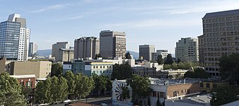
Сан -Хосе , официально город Сан -Хосе ( испанский для « Святого Иосифа » [ 14 ] / ˌ än z z hoʊ z z eh , - ˈ s he / san -zay ; - say , Испанский: [saŋ xoˈse] ), [ 15 ] является крупнейшим городом в Северной Калифорнии как населением, так и с населением. С населением 2022 года 971 233, [ 9 ] Это самый густонаселенный город как в районе залива , так и в Сан -Хосе -Сан -Франциско -Окленде , который в 2022 году составил 7,5 миллионов и 9,0 миллионов соответственно. [ 16 ] [ 17 ] -Третий по численности густонаселенного города в Калифорнии после Лос-Анджелеса и Сан-Диего , а также 13-й-густонаселенный в Соединенных Штатах . [ 18 ] [ 19 ] Расположенный в центре долины Санта -Клара на южном берегу залива Сан -Франциско , Сан -Хосе охватывает площадь 179,97 кв. Миль (466,1 км 2 ) Сан -Хосе является округом округа Санта -Клара и основным компонентом столичного статистического района Сан -Хосе -Саннивейл -Санта -Клара, в 2018 году население около двух миллионов жителей в 2018 году. [ 20 ]
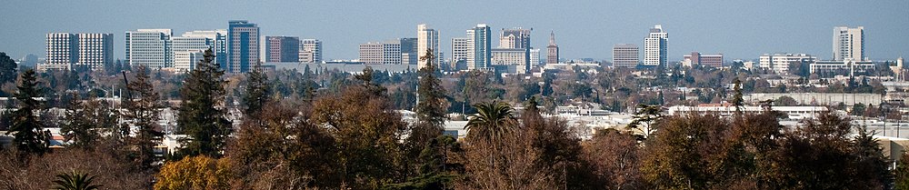
San Jose is notable for its innovation, cultural diversity,[21] affluence,[22] and sunny and mild Mediterranean climate.[23] Its connection to the booming high tech industry phenomenon known as Silicon Valley[24] prompted Mayor Tom McEnery to adopt the city motto of "Capital of Silicon Valley" in 1988 to promote the city.[25] Major global tech companies including Cisco Systems, eBay, Adobe Inc., PayPal, Broadcom, and Zoom maintain their headquarters in San Jose. One of the wealthiest major cities in the world, San Jose has the third-highest GDP per capita (after Zürich and Oslo)[26] and the fifth-most expensive housing market.[27] It is home to one of the world's largest overseas Vietnamese populations,[28] a Hispanic community that makes up over 40% of the city's residents,[29] и исторические этнические анклавы, такие как Джаптантаун и Маленькая Португалия .
Before the arrival of the Spanish, the area around San Jose was long inhabited by the Tamien nation of the Ohlone peoples of California. San Jose was founded on November 29, 1777, as the Pueblo de San José de Guadalupe, the first city founded in the Californias.[30] It became a part of Mexico in 1821 after the Mexican War of Independence.
Following the American Conquest of California during the Mexican–American War, the territory was ceded to the United States in 1848. After California achieved statehood two years later, San Jose was designated as the state's first capital.[31] Following World War II, San Jose experienced an economic boom, with a rapid population growth and aggressive annexation of nearby cities and communities carried out in the 1950s and 1960s. The rapid growth of the high-technology and electronics industries further accelerated the transition from an agricultural center to an urbanized metropolitan area. Results of the 1990 U.S. census indicated that San Jose had officially surpassed San Francisco as the most populous city in Northern California.[32] By the 1990s, San Jose had become the global center for the high tech and internet industries and was California's fastest-growing economy for 2015–2016.[33] Between April 2020 and July 2022, San Jose lost 42,000 people, 4.1% of its population, dropping to 12th largest city position in largest city ranking.[34]
Name
[edit]San Jose is named after el Pueblo de San José de Guadalupe (Spanish for 'the Town of Saint Joseph of Guadalupe'), the city's predecessor, which was eventually located in the area of what is now the Plaza de César Chávez. In the 19th century, print publications used the spelling "San José" for both the city and its eponymous township.[35][36] On December 11, 1943, the United States Board on Geographic Names ruled that the city's name should be spelled "San Jose" based on local usage and the formal incorporated name.[37]
In the 1960s and 1970s, some residents and officials advocated for returning to the original spelling of "San José", with the acute accent on the "e", to acknowledge the city's Mexican origin and Mexican-American population. On June 2, 1969, the city adopted a flag designed by historian Clyde Arbuckle that prominently featured the inscription "SAN JOSÉ, CALIFORNIA".[38] On June 16, 1970, San Jose State College officially adopted "San José" as the city's name, including in the college's own name.[39] On August 20, 1974, the San Jose City Council approved a proposal by Catherine Linquist to rename the city "San José"[40][41] but reversed itself a week later under pressure from residents concerned with the cost of changing typewriters, documents, and signs.[42] On April 3, 1979, the city council once again adopted "San José" as the spelling of the city name on the city seal, official stationery, office titles and department names.[43] As late as 2010, the 1965 city charter stated the name of the municipal corporation as City of San Jose, without the accent mark,[44][45] but later editions have added the accent mark.[14]
By convention, the spelling San José is only used when the name is spelled in mixed upper- and lowercase letters, but not when the name is spelled only in uppercase letters, as on the city logo. The accent reflects the Spanish version of the name, and the dropping of accents in all-capital writing was once typical in Spanish. While San José is commonly spelled both with and without the acute accent over the "e", the city's official guidelines indicate that it should be spelled with the accent most of the time and sets forth narrow exceptions, such as when the spelling is in URLs, when the name appears in all-capital letters, when the name is used on social media sites where the diacritical mark does not render properly, and where San Jose is part of the proper name of another organization or business, such as San Jose Chamber of Commerce, that has chosen not to use the accent-marked name.[46][47][48]
History
[edit]Precolonial period
[edit]San Jose, along with most of the Santa Clara Valley, has been home to the Tamien group (also spelled as Tamyen, Thamien) of the Ohlone people since around 4,000 BC.[49][50][51] The Tamien spoke Tamyen language of the Ohlone language family.
During the era of Spanish colonization and the subsequent building of Spanish missions in California, the Tamien people's lives changed dramatically. From 1777 onward, most of the Tamien people were forcibly enslaved at Mission Santa Clara de Asís or Mission San José where they were baptized and educated to be Catholic neophytes, also known as Mission Indians. This continued until the mission was secularized by the Mexican Government in 1833. A large majority of the Tamien died either from disease in the missions, or as a result of the state sponsored genocide. Some surviving families remained intact, migrating to Santa Cruz after their ancestral lands were granted to Spanish and Mexican Immigrants.[52]
Spanish period
[edit]
California was claimed as part of the Spanish Empire in 1542, when explorer Juan Rodríguez Cabrillo charted the Californian coast. During this time Alta California and the Baja California peninsula were administered together as Province of the Californias (Spanish: Provincia de las Californias). For nearly 200 years, the Californias remained a distant frontier region largely controlled by the numerous Native Nations and largely ignored by the government of the Viceroyalty of New Spain in Mexico City. Shifting power dynamics in North America—including the British/American victory and acquisition of North America, east of the Mississippi following the 1763 Treaty of Paris, as well as the start of Russian colonization of northwestern North America— prompted Spanish/Mexican authorities to sponsor the Portolá Expedition to survey Northern California in 1769.[53]
In 1776, the Californias were included as part of the Captaincy General of the Provincias Internas, a large administrative division created by José de Gálvez, Spanish Minister of the Indies, in order to provide greater autonomy for the Spanish Empire's borderlands. That year, King Carlos III of Spain approved an expedition by Juan Bautista de Anza to survey the San Francisco Bay Area, in order to choose the sites for two future settlements and their accompanying mission. De Anza initially chose the site for a military settlement in San Francisco, for the Royal Presidio of San Francisco, and Mission San Francisco de Asís. On his way back to Mexico from San Francisco, de Anza chose the sites in Santa Clara Valley for a civilian settlement, San Jose, on the eastern bank of the Guadalupe River, and a mission on its western bank, Mission Santa Clara de Asís.[54]

San Jose was officially founded as California's first civilian settlement on November 29, 1777, as the Pueblo de San José de Guadalupe by José Joaquín Moraga, under orders of Antonio María de Bucareli y Ursúa, Viceroy of New Spain.[55] San Jose served as a strategic settlement along El Camino Real, connecting the military fortifications at the Monterey Presidio and the San Francisco Presidio, as well as the California mission network.[56] In 1791, due to the severe flooding which characterized the pueblo, San Jose's settlement was moved approximately a mile south, centered on the Pueblo Plaza (modern-day Plaza de César Chávez).[57]
In 1800, due to the growing population in the northern part of the Californias, Diego de Borica, Governor of the Californias, officially split the province into two parts: Alta California (Upper California), which would eventually become several western U.S. states, and Baja California (Lower California), which would eventually become two Mexican states.
Mexican period
[edit]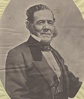
San Jose became part of the First Mexican Empire in 1821, after Mexico's War of Independence was won against the Spanish Crown, and in 1824, part of the First Mexican Republic. With its newfound independence, and the triumph of the republican movement, Mexico set out to diminish the Catholic Church's power within Alta California by secularizing the California missions in 1833.[citation needed]
In 1824, in order to promote settlement and economic activity within sparsely populated California, the Mexican government began an initiative, for Mexican and foreign citizens alike, to settle unoccupied lands in California. Between 1833 and 1845, thirty-eight rancho land grants were issued in the Santa Clara Valley, 15 of which were located within modern-day San Jose's borders. Numerous prominent historical figures were among those granted rancho lands in the Santa Valley, including James A. Forbes, founder of Los Gatos, California (granted Rancho Potrero de Santa Clara), Antonio Suñol, Alcalde of San Jose (granted Rancho Los Coches), and José María Alviso, Alcalde of San Jose (granted Rancho Milpitas).[citation needed]
In 1835, San Jose's population of approximately 700 people included 40 foreigners, primarily Americans and Englishmen. By 1845, the population of the pueblo had increased to 900, primarily due to American immigration. Foreign settlement in San Jose and California was rapidly changing Californian society, bringing expanding economic opportunities and foreign culture.[58]
By 1846, native Californios had long expressed their concern for the overrunning of California society by its growing and wealthy Anglo-American community.[59] During the 1846 Bear Flag Revolt, Captain Thomas Fallon led nineteen volunteers from Santa Cruz to the pueblo of San Jose, which his forces easily captured. The raising of the flag of the California Republic ended Mexican rule in Alta California on July 14, 1846.[60][61]
American period
[edit]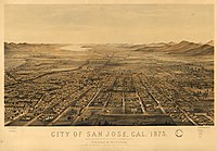

By the end of 1847, the Conquest of California by the United States was complete, as the Mexican–American War came to an end.[50] In 1848, the Treaty of Guadalupe Hidalgo formally ceded California to the United States, as part of the Mexican Cession. On December 15, 1849, San Jose became the capital of the unorganized territory of California. With California's Admission to the Union on September 9, 1850, San Jose became the state's first capital.[62]
On March 27, 1850, San Jose was incorporated. It was incorporated on the same day as San Diego and Benicia; together, these three cities followed Sacramento as California's earliest incorporated cities.[63] Josiah Belden, who had settled in California in 1842 after traversing the California Trail as part of the Bartleson Party and later acquired a fortune, was the city's first mayor.[64] San Jose was briefly California's first state capital, and legislators met in the city from 1849 to 1851. (Monterey was the capital during the period of Spanish California and Mexican California).[65] The first capitol no longer exists; the Plaza de César Chávez now lies on the site, which has two historical markers indicating where California's state legislature first met.[66]
In the period 1900 through 1910, San Jose served as a center for pioneering invention, innovation, and impact in both lighter-than-air and heavier-than-air flight. These activities were led principally by John Montgomery and his peers. The City of San Jose has established Montgomery Park, a Monument at San Felipe and Yerba Buena Roads, and John J. Montgomery Elementary School in his honor. During this period, San Jose also became a center of innovation for the mechanization and industrialization of agricultural and food processing equipment.[67]
Though not affected as severely as San Francisco, San Jose also suffered significant damage from the 1906 San Francisco earthquake. Over 100 people died at the Agnews Asylum (later Agnews State Hospital) after its walls and roof collapsed,[68] and San Jose High School's three-story stone-and-brick building was also destroyed. The period during World War II was tumultuous; Japanese Americans primarily from Japantown were sent to internment camps, including the future mayor Norman Mineta. Following the Los Angeles zoot suit riots, anti-Mexican violence took place during the summer of 1943. In 1940, the Census Bureau reported San Jose's population as 98% white.[69]

As World War II started, the city's economy shifted from agriculture (the Del Monte cannery was the largest employer and closed in 1999[70]) to industrial manufacturing with the contracting of the Food Machinery Corporation (later known as FMC Corporation) by the United States War Department to build 1,000 Landing Vehicle Tracked.[71] After World War II, FMC (later United Defense, and currently BAE Systems) continued as a defense contractor, with the San Jose facilities designing and manufacturing military platforms such as the M113 Armored Personnel Carrier, the Bradley Fighting Vehicle, and various subsystems of the M1 Abrams battle tank.[72]
IBM established its first West Coast operations in San Jose in 1943 with a downtown punch card plant, and opened an IBM Research lab in 1952. Reynold B. Johnson and his team developed direct access storage for computers,[73] inventing the RAMAC 305 and the hard disk drive; the technological side of San Jose's economy grew.[74]
During the 1950s and 1960s, City Manager A. P. "Dutch" Hamann led the city in a major growth campaign. The city annexed adjacent areas, such as Alviso and Cambrian Park, providing large areas for suburbs. An anti-growth reaction to the effects of rapid development emerged in the 1970s, championed by mayors Norman Mineta and Janet Gray Hayes. Despite establishing an urban growth boundary, development fees, and the incorporations of Campbell and Cupertino, development was not slowed, but rather directed into already-incorporated areas.[71]
San Jose's position in Silicon Valley triggered further economic and population growth. Results from the 1990 U.S. Census indicated that San Jose surpassed San Francisco as the most populous city in the Bay Area for the first time.[32] This growth led to the highest housing-cost increase in the nation, 936% between 1976 and 2001.[75] Efforts to increase density continued into the 1990s when an update of the 1974 urban plan kept the urban growth boundaries intact and voters rejected a ballot measure to ease development restrictions in the foothills. As of 2006, sixty percent of the housing built in San Jose since 1980 and over three-quarters of the housing built since 2000 have been multifamily structures, reflecting a political propensity toward Smart Growth planning principles.[76]
Geography
[edit]
San Jose is located at 37°20′10″N 121°53′26″W / 37.33611°N 121.89056°W. San Jose is located within the Santa Clara Valley, in the southern part of the Bay Area in Northern California. The northernmost portion of San Jose touches San Francisco Bay at Alviso, though most of the city lies away from the bayshore. According to the United States Census Bureau, the city has a total area of 180.0 sq mi (466 km2), making the fourth-largest city in California by land area (after Los Angeles, San Diego and California City).[18]
San Jose lies between the San Andreas Fault, the source of the 1989 Loma Prieta earthquake, and the Calaveras Fault. San Jose is shaken by moderate earthquakes on average one or two times a year. These quakes originate just east of the city on the creeping section of the Calaveras Fault, which is a major source of earthquake activity in Northern California. On April 14, 1984, at 1:15 pm local time, a 6.2 magnitude earthquake struck the Calaveras Fault near San Jose's Mount Hamilton.[77] The most serious earthquake, in 1906, damaged many buildings in San Jose as described earlier. Earlier significant quakes rocked the city in 1839, 1851, 1858, 1864, 1865, 1868, and 1891. The Daly City Earthquake of 1957 caused some damage. The Loma Prieta earthquake of 1989 also did some damage to parts of the city.
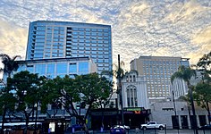
Cityscape
[edit]San Jose's expansion was made by the design of "Dutch" Hamann, the City Manager from 1950 to 1969. During his administration, with his staff referred to as "Dutch's Panzer Division", the city annexed property 1,389 times,[78] growing the city from 17 to 149 sq mi (44 to 386 km2),[79] absorbing the communities named above, changing their status to "neighborhoods."
They say San José is going to become another Los Angeles. Believe me, I'm going to do everything in my power to make that come true.
— "Dutch" Hamann, 1965[80]
Sales taxes were a chief source of revenue. Hamann would determine where major shopping areas would be, and then annex narrow bands of land along major roadways leading to those locations, pushing tentacles across the Santa Clara Valley and, in turn, walling off the expansion of adjacent communities.[81]
During his reign, it was said the City Council would vote according to Hamann's nod. In 1963, the State of California imposed Local Agency Formation Commissions statewide, but largely to try to maintain order with San Jose's aggressive growth. Eventually the political forces against growth grew as local neighborhoods bonded together to elect their own candidates, ending Hamann's influence and leading to his resignation.[82] While the job was not complete, the trend was set. The city had defined its sphere of influence in all directions, sometimes chaotically leaving unincorporated pockets to be swallowed up by the behemoth, sometimes even at the objection of the residents.[78]
Major thoroughfares in the city include Monterey Road, the Stevens Creek Boulevard/San Carlos Street corridor, Santa Clara Street/Alum Rock Avenue corridor, Almaden Expressway, Capitol Expressway, and 1st Street (San Jose).
Topography
[edit]


The Guadalupe River runs from the Santa Cruz Mountains flowing north through San Jose, ending in the San Francisco Bay at Alviso. Along the southern part of the river is the neighborhood of Almaden Valley, originally named for the mercury mines which produced mercury needed for gold extraction from quartz during the California Gold Rush as well as mercury fulminate blasting caps and detonators for the U.S. military from 1870 to 1945.[83] East of the Guadalupe River, Coyote Creek also flows to south San Francisco Bay and originates on Mount Sizer near Henry W. Coe State Park and the surrounding hills in the Diablo Range, northeast of Morgan Hill, California.
The lowest point in San Jose is 13 ft (4.0 m) below sea level at the San Francisco Bay in Alviso;[84] the highest is 2,125 ft (648 m).[85] Because of the proximity to Lick Observatory atop Mount Hamilton, San Jose has taken several steps to reduce light pollution, including replacing all street lamps and outdoor lighting in private developments with low pressure sodium lamps.[86] To recognize the city's efforts, the asteroid 6216 San Jose was named after the city.[87]
There are four distinct valleys in the city of San Jose: Almaden Valley, situated on the southwest fringe of the city; Evergreen Valley to the southeast, which is hilly all throughout its interior; Santa Clara Valley, which includes the flat, main urban expanse of the South Bay; and the rural Coyote Valley, to the city's extreme southern fringe.[88]
The extensive droughts in California, coupled with the drainage of the reservoir at Anderson Lake for seismic repairs, have strained the city's water security.[89][90] San Jose has suffered from lack of precipitation and water scarcity to the extent that some residents may run out of household water by the summer of 2022.[91]
Climate
[edit]San Jose, like most of the Bay Area, has a Mediterranean climate (Köppen: Csb),[92][93] with warm to hot, dry summers and cool, wet winters. San Jose has an average of 298 days of sunshine and an annual mean temperature of 61.4 °F (16.3 °C). It lies inland, surrounded on three sides by mountains, and does not front the Pacific Ocean like San Francisco. As a result, the city is somewhat more sheltered from rain, barely avoiding a cold semi-arid (BSk) climate.[92]
Like most of the Bay Area, San Jose is made up of dozens of microclimates. Because of a more prominent rain shadow from the Santa Cruz Mountains, Downtown San Jose experiences the lightest rainfall in the city, while South San Jose, only 10 mi (16 km) distant, experiences more rainfall, and somewhat more extreme temperatures.
The monthly daily average temperature ranges from around 50 °F (10 °C) in December and January to around 70 °F (21 °C) in July and August.[94] The highest temperature ever recorded in San Jose was 109 °F (43 °C) on September 6, 2022; the lowest was 18 °F (−7.8 °C) on January 6, 1894. On average, there are 2.7 mornings annually where the temperature drops to, or below, the freezing mark; and sixteen afternoons where the high reaches or exceeds 90 °F or 32.2 °C. Diurnal temperature variation is far wider than along the coast or in San Francisco but still a shadow of what is seen in the Central Valley.
"Rain year" precipitation has ranged from 4.83 in (122.7 mm) between July 1876 and June 1877 to 30.30 in (769.6 mm) between July 1889 and June 1890, although at the current site since 1893 the range is from 5.33 in (135.4 mm) in "rain year" 2020–21 to 30.25 in (768.3 mm) in "rain year" 1982–83. 2020-2021 was the lowest precipitation year ever, in 127 years of precipitation records in San Jose. The most precipitation in one month was 12.38 in (314.5 mm) in January 1911. The maximum 24-hour rainfall was 3.60 in (91.4 mm) on January 30, 1968. On August 16, 2020, one of the most widespread and strong thunderstorm events in recent Bay Area history occurred as an unstable humid air mass moved up from the south and triggered multiple dry thunderstorms [95] which caused many fires to be ignited by 300+ lightning strikes in the surrounding hills. The CZU lightning complex fires took almost 5 months to fully be controlled. Over 86,000 acres were burned and nearly 1500 buildings were destroyed.[96][97]
The snow level drops as low as 4,000 ft (1,220 m) above sea level, or lower, occasionally coating nearby Mount Hamilton and, less frequently, the Santa Cruz Mountains, with snow that normally lasts a few days. Snow will snarl traffic traveling on State Route 17 towards Santa Cruz. Snow rarely falls in San Jose; the most recent snow to remain on the ground was on February 5, 1976, when many residents around the city saw as much as 3 in (0.076 m) on car and roof tops. The official observation station measured only 0.5 in (0.013 m) of snow.[98]
| Climate data for San Jose International Airport (KSJC), California (1991–2020 normals, extremes 1893–present) | |||||||||||||
|---|---|---|---|---|---|---|---|---|---|---|---|---|---|
| Month | Jan | Feb | Mar | Apr | May | Jun | Jul | Aug | Sep | Oct | Nov | Dec | Year |
| Record high °F (°C) | 79 (26) |
81 (27) |
89 (32) |
95 (35) |
102 (39) |
107 (42) |
108 (42) |
105 (41) |
109 (43) |
101 (38) |
85 (29) |
79 (26) |
109 (43) |
| Mean maximum °F (°C) | 68.2 (20.1) |
73.2 (22.9) |
79.1 (26.2) |
85.7 (29.8) |
89.8 (32.1) |
96.9 (36.1) |
95.0 (35.0) |
95.7 (35.4) |
95.7 (35.4) |
89.4 (31.9) |
77.5 (25.3) |
68.0 (20.0) |
99.8 (37.7) |
| Mean daily maximum °F (°C) | 59.8 (15.4) |
62.4 (16.9) |
65.9 (18.8) |
69.2 (20.7) |
73.8 (23.2) |
79.1 (26.2) |
80.8 (27.1) |
81.4 (27.4) |
80.7 (27.1) |
75.8 (24.3) |
66.1 (18.9) |
59.5 (15.3) |
71.2 (21.8) |
| Daily mean °F (°C) | 50.8 (10.4) |
53.2 (11.8) |
56.1 (13.4) |
58.8 (14.9) |
63.0 (17.2) |
67.3 (19.6) |
69.5 (20.8) |
70.0 (21.1) |
69.0 (20.6) |
64.3 (17.9) |
55.9 (13.3) |
50.6 (10.3) |
60.7 (15.9) |
| Mean daily minimum °F (°C) | 41.8 (5.4) |
43.9 (6.6) |
46.3 (7.9) |
48.4 (9.1) |
52.1 (11.2) |
55.5 (13.1) |
58.1 (14.5) |
58.6 (14.8) |
57.2 (14.0) |
52.7 (11.5) |
45.7 (7.6) |
41.7 (5.4) |
50.2 (10.1) |
| Mean minimum °F (°C) | 32.6 (0.3) |
35.0 (1.7) |
38.1 (3.4) |
41.3 (5.2) |
46.1 (7.8) |
50.1 (10.1) |
53.8 (12.1) |
53.9 (12.2) |
50.8 (10.4) |
45.5 (7.5) |
36.8 (2.7) |
32.2 (0.1) |
30.7 (−0.7) |
| Record low °F (°C) | 18 (−8) |
24 (−4) |
25 (−4) |
26 (−3) |
32 (0) |
33 (1) |
40 (4) |
39 (4) |
35 (2) |
30 (−1) |
22 (−6) |
19 (−7) |
18 (−8) |
| Average rainfall inches (mm) | 2.97 (75) |
3.24 (82) |
2.64 (67) |
1.24 (31) |
0.54 (14) |
0.17 (4.3) |
0.01 (0.25) |
0.03 (0.76) |
0.07 (1.8) |
0.80 (20) |
1.36 (35) |
3.07 (78) |
16.14 (410) |
| Average rainy days (≥ 0.01 in) | 10.2 | 11.5 | 9.3 | 6.4 | 4.0 | 1.2 | 0.2 | 0.4 | 0.9 | 2.7 | 6.9 | 10.7 | 64.4 |
| Source: NOAA[99][100] | |||||||||||||
Neighborhoods and districts
[edit]The city is generally divided into the following areas: Central San Jose (centered on Downtown San Jose), West San Jose, North San Jose, East San Jose, and South San Jose. Many of San Jose's districts and neighborhoods were previously unincorporated communities or separate municipalities that were later annexed by the city.
Besides those mentioned above, some well-known communities within San Jose include Japantown, Rose Garden, Midtown San Jose, Willow Glen, Naglee Park, Burbank, Winchester, Alviso, East Foothills, Alum Rock, Communications Hill, Little Portugal, Blossom Valley, Cambrian, Almaden Valley, Little Saigon, Silver Creek Valley, Evergreen Valley, Mayfair, Edenvale, Santa Teresa, Seven Trees, Coyote Valley, and Berryessa. A distinct ethnic enclave in San Jose is the Washington-Guadalupe neighborhood, immediately south of the SoFA District; this neighborhood is home to a community of Hispanics, centered on Willow Street.
- Selection of neighborhoods in San Jose
-

-
-
-

-

-

-

-

-
-

-

-
-

-

-

-

-


Parks
[edit]


San Jose possesses about 15,950 acres (6,455 ha) of parkland in its city limits, including a part of the expansive Don Edwards San Francisco Bay National Wildlife Refuge. The city's oldest park is Alum Rock Park, established in 1872.[101] In its 2013 ParkScore ranking, The Trust for Public Land, a national land conservation organization, reported that San Jose was tied with Albuquerque and Omaha for having the 11th best park system among the 50 most populous U.S. cities.[102]
- Almaden Quicksilver County Park, 4,147 acres (16.78 km2) of former mercury mines in South San Jose (operated and maintained by the Santa Clara County Parks and Recreation Department).
- Alum Rock Park, 718 acres (2.91 km2) in East San Jose, the oldest municipal park in California and one of the largest municipal parks in the United States.
- Children's Discovery Museum hosts an outdoor park-like setting, featuring the world's largest permanent Monopoly game, per the Guinness Book of World Records.[103] Caretakers for this attraction include the 501(c)3 non-profit group Monopoly in the Park.
- Circle of Palms Plaza, a ring of palm trees surrounding a California state seal and historical landmark at the site of the first state capitol
- Emma Prusch Farm Park, 43.5 acres (17.6 ha) in East San Jose. Donated by Emma Prusch to demonstrate the valley's agricultural past, it includes a 4-H barn (the largest in San Jose), community gardens, a rare-fruit orchard, demonstration gardens, picnic areas, and expanses of lawn.[104] Chickens, ducks, and peafowl roam the park freely.
- Field Sports Park, Santa Clara County's only publicly owned firing range, located in south San Jose[105]
- Iris Chang Park, located in North San Jose, is dedicated to the memory of Iris Shun-Ru Chang, author of The Rape of Nanking and a San Jose resident.
- Kelley Park, including diverse facilities such as Happy Hollow Park & Zoo (a child-centric amusement park), the Japanese Friendship Garden (Kelley Park), History Park at Kelley Park, and the Portuguese Historical Museum within the history park
- Martial Cottle Park, a former agricultural farm, in South San Jose. Operated by Santa Clara County Parks and Recreation Department
- Oak Hill Memorial Park, California's oldest secular cemetery
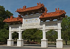
- Overfelt Gardens, including the Chinese Cultural Garden
- Plaza de César Chávez, a small park in Downtown, hosts outdoor concerts and the Christmas in the Park display
- Raging Waters, water park with water slides and other water attractions. This sits within Lake Cunningham Park
- Rosicrucian Park, nearly an entire city block in the Rose Garden neighborhood; the Park offers a setting of Egyptian and Moorish architecture set among lawns, rose gardens, statuary, and fountains, and includes the Rosicrucian Egyptian Museum, Planetarium, Research Library, Peace Garden and Visitors Center
- San Jose Municipal Rose Garden, 5+1⁄2 acres (22,000 m2) park in the Rose Garden neighborhood, featuring over 4,000 rose bushes
Trails
[edit]
A 2011 study by Walk Score ranked San Jose the nineteenth most walkable of 50 largest cities in the United States.[106]
San Jose's trail network of 60 mi (100 km) of recreational and active transportation trails throughout the city.[107] The major trails in the network include:
- Coyote Creek Trail
- Guadalupe River Trail
- Los Gatos Creek Trail
- Los Alamitos Creek Trail
- Penitencia Creek Trail
- Silver Creek Valley Trail
This large urban trail network, recognized by Prevention Magazine as the nation's largest, is linked to trails in surrounding jurisdictions and many rural trails in surrounding open space and foothills. Several trail systems within the network are designated as part of the National Recreation Trail, as well as regional trails such as the San Francisco Bay Trail and Bay Area Ridge Trail.
Wildlife
[edit]Early written documents record the local presence of migrating salmon in the Rio Guadalupe dating as far back as the 18th century.[108] Both steelhead (Oncorhynchus mykiss) and King salmon are extant in the Guadalupe River, making San Jose the southernmost major U. S. city with known salmon spawning runs, the other cities being Anchorage; Seattle; Portland and Sacramento.[109] Runs of up to 1,000 Chinook or King Salmon (Oncorhynchus tshawytscha) swam up the Guadalupe River each fall in the 1990s, but have all but vanished in the current decade apparently blocked from access to breeding grounds by impassable culverts, weirs and wide, exposed and flat concrete paved channels installed by the Santa Clara Valley Water District.[110] In 2011 a small number of Chinook salmon were filmed spawning under the Julian Street bridge.[111]
Conservationist Roger Castillo, who discovered the remains of a mammoth on the banks of the Guadalupe River in 2005, found that a herd of tule elk (Cervus canadensis) had recolonized the hills of south San Jose east of Highway 101 in early 2019.[112]
At the southern edge of San José, Coyote Valley is a corridor for wildlife migration between the Santa Cruz Mountains and the Diablo Range.[113][114]
Demographics
[edit]| Census | Pop. | Note | %± |
|---|---|---|---|
| 1870 | 9,089 | — | |
| 1880 | 12,567 | 38.3% | |
| 1890 | 18,060 | 43.7% | |
| 1900 | 21,500 | 19.0% | |
| 1910 | 28,946 | 34.6% | |
| 1920 | 39,642 | 37.0% | |
| 1930 | 57,651 | 45.4% | |
| 1940 | 68,457 | 18.7% | |
| 1950 | 95,280 | 39.2% | |
| 1960 | 204,196 | 114.3% | |
| 1970 | 459,913 | 125.2% | |
| 1980 | 629,400 | 36.9% | |
| 1990 | 782,248 | 24.3% | |
| 2000 | 894,943 | 14.4% | |
| 2010 | 945,942 | 5.7% | |
| 2020 | 1,013,240 | 7.1% | |
| 2023 (est.) | 969,655 | [115] | −4.3% |
| U.S. Decennial Census[116] 2010–2020[9] | |||
In 2022, the US Census Bureau released its new population estimates. With a total population of 971,233,[117] San Jose showed a 4.1% decline in population since the 2020 census. Some reasons for this decline are people leaving the area for more affordable cities and more remote working opportunities.[118]
| Historical Racial composition | 2020 [9] | 2010[119] | 1990[69] | 1970[69] | 1940[69] |
|---|
2020
[edit]| Race / Ethnicity (NH = Non-Hispanic) | Pop 2000[120] | Pop 2010[121] | Pop 2020[122] | % 2000 | % 2010 | % 2020 |
|---|---|---|---|---|---|---|
| White alone (NH) | 322,534 | 271,382 | 236,095 | 36.04% | 28.69% | 23.30% |
| Black or African American alone (NH) | 29,495 | 27,508 | 27,422 | 3.30% | 2.91% | 2.71% |
| Native American or Alaska Native alone (NH) | 2,959 | 2,255 | 1,921 | 0.33% | 0.24% | 0.19% |
| Asian alone (NH) | 238,378 | 300,022 | 386,993 | 26.64% | 31.72% | 38.19% |
| Pacific Islander alone (NH) | 3,093 | 3,492 | 3,460 | 0.35% | 0.37% | 0.34% |
| Other race alone (NH) | 1,699 | 1,820 | 4,808 | 0.19% | 0.19% | 0.47% |
| Mixed race or Multiracial (NH) | 26,796 | 25,827 | 36,275 | 2.99% | 2.73% | 3.58% |
| Hispanic or Latino (any race) | 269,989 | 313,636 | 316,266 | 30.17% | 33.16% | 31.21% |
| Total | 894,943 | 945,942 | 1,013,240 | 100.00% | 100.00% | 100.00% |
2010
[edit]

The 2010 United States Census[123] reported that San Jose had a population of 945,942. The population density was 5,256.2 inhabitants per square mile (2,029.4/km2). The racial makeup of San Jose was 404,437 (42.8%) White, 303,138 (32.0%) Asian (10.4% Vietnamese, 6.7% Chinese, 5.6% Filipino, 4.6% Indian, 1.2% Korean, 1.2% Japanese, 0.3% Cambodian, 0.2% Thai, 0.2% Pakistani, 0.2% Laotian), 30,242 (3.2%) African American, 8,297 (0.9%) Native American, 4,017 (0.4%) Pacific Islander, 148,749 (15.7%) from other races, and 47,062 (5.0%) from two or more races. There were 313,636 residents of Hispanic or Latino background (33.2%). 28.2% of the city's population was of Mexican descent; the next largest Hispanic groups were those of Salvadoran (0.7%) and Puerto Rican (0.5%) heritage. Non-Hispanic Whites were 28.7% of the population in 2010,[119] down from 75.7% in 1970.[69]
The census reported that 932,620 people (98.6% of the population) lived in households, 9,542 (1.0%) lived in non-institutionalized group quarters, and 3,780 (0.4%) were institutionalized. There were 301,366 households, out of which 122,958 (40.8%) had children under the age of 18 living in them, 162,819 (54.0%) were opposite-sex married couples living together, 37,988 (12.6%) had a female householder with no husband present, 18,702 (6.2%) had a male householder with no wife present. There were 16,900 (5.6%) unmarried opposite-sex partnerships, and 2,458 (0.8%) same-sex married couples or partnerships. 59,385 households (19.7%) were made up of individuals, and 18,305 (6.1%) had someone living alone who was 65 years of age or older. The average household size was 3.09. There were 219,509 families (72.8% of all households); the average family size was 3.54.
The age distribution of the city was as follows: 234,678 people (24.8%) were under the age of 18, 89,457 people (9.5%) aged 18 to 24, 294,399 people (31.1%) aged 25 to 44, 232,166 people (24.5%) aged 45 to 64, and 95,242 people (10.1%) who were 65 years of age or older. The median age was 35.2 years. For every 100 females, there were 101.1 males. For every 100 females age 18 and over, there were 99.8 males.
There were 314,038 housing units at an average density of 1,745.0 per square mile (673.7/km2), of which 176,216 (58.5%) were owner-occupied, and 125,150 (41.5%) were occupied by renters. The homeowner vacancy rate was 1.6%; the rental vacancy rate was 4.3%. 553,436 people (58.5% of the population) lived in owner-occupied housing units and 379,184 people (40.1%) lived in rental housing units.
2000
[edit]


According to the 2000 United States Census, there were 894,943 people, 276,598 households, and 203,576 families residing in the city.[124]
The population density was 5,117.9 inhabitants per square mile (1,976.0/km2). There were 281,841 housing units at an average density of 1,611.8 per square mile (622.3/km2). Of the 276,598 households, 38.3% had children under the age of 18 living with them, 56.0% were married couples living together, 11.7% had a female householder with no husband present, and 26.4% were non-families. 18.4% of all households were made up of individuals, and 4.9% had someone living alone who was 65 years of age or older. The average household size was 3.20 and the average family size was 3.62.
In the city, the age distribution of the population shows 26.4% under the age of 18, 9.9% from 18 to 24, 35.4% from 25 to 44, 20.0% from 45 to 64, and 8.3% who were 65 years of age or older. The median age was 33 years. For every 100 females, there were 103.3 males. For every 100 females age 18 and over, there were 102.5 males.
According to a 2007 estimate, the median income for a household in the city was the highest in the U.S. for any city with more than a quarter-million residents with $76,963 annually. The median income for a family was $86,822.[125] Males had a median income of $49,347 versus $36,936 for females. The per capita income for the city was $26,697. About 6.0% of families and 8.8% of the population were below the poverty line, including 10.3% of those under age 18 and 7.4% of those age 65 or over.
Economy
[edit]


The CSA San Jose shares with San Francisco was the country's third-largest urban economy as of 2018, with a GDP of $1.03 trillion.[126] Of the 500+ primary statistical areas in the U.S., this CSA had among the highest GDP per capita in 2018, at $106,757.[126]
San Jose is a United States Foreign-Trade Zone. The city received its Foreign Trade Zone grant from the U.S. Federal Government in 1974, making it the 18th foreign-trade zone established in the United States. Under its grant, the City of San Jose is granted jurisdiction to oversee and administer foreign trade in Santa Clara County, Monterey County, San Benito County, Santa Cruz County, and in the southern parts of San Mateo County and Alameda County.[127]
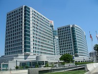
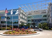
San Jose hosts many companies with more than 1,000 employees, including the headquarters of:
San Jose also hosts major facilities for Becton Dickinson, Ericsson, Hewlett Packard Enterprise, Hitachi, IBM, Kaiser Permanente, KLA Tencor, Lockheed Martin, Nippon Sheet Glass, and Qualcomm. The North American headquarters of Samsung Semiconductor are located in San Jose.[128][129] Approximately 2000 employees will work at the new Samsung campus which opened in 2015.
Other large companies based in San Jose include:
- Align Technology
- Atmel
- Bloom Energy
- CEVA
- Cypress Semiconductor
- Cohesity, Echelon
- Extreme Networks
- GlobalLogic
- Harmonic
- Integrated Device Technology
- Maxim Integrated
- Micrel
- Move
- Netgear
- Novellus Systems
- Nutanix
- Oclaro
- OCZ
- Quantum
- SunPower
- Sharks Sports and Entertainment
- Supermicro
- Tessera Technologies
- TiVo
- Ultratech
- VeriFone
- Viavi Solutions
- Zoom Video Communications
- Zscaler
Sizable government employers include the city government, Santa Clara County, and San Jose State University.[130] Acer's United States division has its offices in San Jose.[131] Prior to its closing, Netcom had its headquarters in San Jose.[132][133]
On July 31, 2015, Cupertino-based Apple Inc. purchased a 40-acre site in San Jose.[134] The site, which is bare land, will be the site of an office and research campus where it is estimated that up to 16,000 employees will be located. Apple paid $138.2 million for the site.[134] The seller, Connecticut-based Five Mile Capital Partners, paid $40 million for the site in 2010.[135]
Wealth
[edit]
It is situated in the most affluent county in California and one of the most affluent counties in the United States.[136][137][138]
With a median home price of $1,085,000[139] and the highest percentage of million-dollar (or more) homes in the United States,[140] San Jose has the most expensive housing market in the United States and the fifth most expensive housing market in the world.[141][142][143]
The cost of living in San Jose and the surrounding areas is among the highest in California and the nation, according to 2004 data.[144] Housing costs are the primary reason for the high cost of living, although the costs in all areas tracked by the ACCRA Cost of Living Index are above the national average. Households in the city limits have the highest disposable income of any city in the U.S. with over 500,000 residents.[145][146]
Silicon Valley
[edit]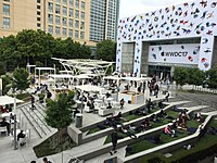
The large concentration of high-technology engineering, computer, and microprocessor companies around San Jose has led the area to be known as Silicon Valley. Area schools such as the University of California, Berkeley, University of California, Santa Cruz, San Jose State University, San Francisco State University, California State University, East Bay, Santa Clara University, and Stanford University pump thousands of engineering and computer science graduates into the local economy every year.
San Jose residents produce more U.S. patents than any other city.[147] On October 15, 2015, the United States Patent and Trademark Office opened a satellite office in San Jose to serve Silicon Valley and the Western United States.[148][149] By April 2018, Google was in the process of planning the "biggest tech campus in Silicon Valley" in San Jose.[150] However, in April 2023, it was reported that Google paused on Google West San Jose Campus constructions due to slowing economic conditions and a decreased requirement for physical office space by tech companies,[151] although the tech ecosystem has also recently become more geographically dispersed.[152]
High economic growth during the tech bubble caused employment, housing prices, and traffic congestion to peak in the late 1990s. As the economy slowed in the early 2000s, employment and traffic congestion was somewhat diminished.[153] In the mid-2000s, traffic along major highways again began to worsen as the economy improved. San Jose had 405,000 jobs within its city limits in 2006, and an unemployment rate of 4.6%. San Jose has the highest median income of any U.S. city with over 280,000 people.
On March 14, 2013, San Jose implemented a public wireless connection in its downtown area. Wireless access points have been placed on outdoor light posts throughout the city.[154]
Media
[edit]San Jose is served by Greater Bay Area media. Print media outlets in San Jose include The Mercury News, the weekly Metro Silicon Valley, El Observador and the Silicon Valley / San Jose Business Journal. The Bay Area's NBC O&O, KNTV 11, is licensed to San Jose. In total, broadcasters in the Bay Area include 34 television stations, 25 AM radio stations, and 55 FM radio stations.[155]
In April 1909, Charles David Herrold, an electronics instructor in San Jose, constructed a radio station to broadcast the human voice. The station, "San Jose Calling" (call letters FN, later FQW), was the world's first radio station with scheduled programming targeted at a general audience.[citation needed] The station became the first to broadcast music in 1910. Herrold's wife Sybil became the first female "disk jockey" in 1912. The station changed hands a number of times before becoming today's[when?] KCBS in San Francisco.[156]
Top employers
[edit]As of June 30, 2023, the top employers in the city were:[157]
| No. | San Jose's Top Employers | Employees |
|---|---|---|
| 1 | County of Santa Clara | 20,000 |
| 2 | City of San Jose | 8,044 |
| 3 | Cisco Systems | 7,500 |
| 4 | Kaiser Permanente | 4,400 |
| 5 | San Jose State University | 4,095 |
| 6 | Adobe Systems, Inc. | 4,000 |
| 7 | Western Digital | 2,891 |
| 8 | Broadcom | 2,805 |
| 9 | PayPal | 2,801 |
| 10 | San Jose Unified School District | 2,516 |
| 11 | ByteDance | 2,500 |
| 12 | Target Stores | 2,437 |
| 13 | eBay | 2,351 |
| 14 | Super Micro Computer, Inc. | 2,219 |
| 15 | IBM | 2,070 |
Culture
[edit]Architecture
[edit]
Because the downtown area is in the flight path to nearby Mineta San Jose International Airport (also evidenced in the above panoramic), there is a height limit for buildings in the downtown area, which is underneath the final approach corridor to the airport. The height limit is dictated by local ordinances, driven by the distance from the runway and a slope defined by Federal Aviation Administration regulations. Core downtown buildings are limited to approximately 300 ft (91 m) but can get taller farther from the airport.[158]
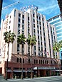
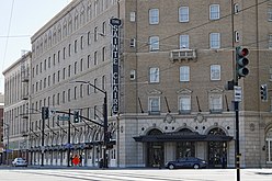
There has been broad criticism over the past few decades of the city's architecture.[159] Citizens have complained that San Jose is lacking in aesthetically pleasing architectural styles. Blame for this lack of architectural "beauty" can be assigned to the re-development of the downtown area from the 1950s onward, in which whole blocks of historic commercial and residential structures were demolished.[160] Exceptions to this include the Downtown Historic District, the Hotel De Anza, and the Hotel Sainte Claire, both of which are listed in the National Register of Historic Places for their architectural and historical significance.

Municipal building projects have experimented more with architectural styles than have most private enterprises.[161] The Children's Discovery Museum, Tech Museum of Innovation, and the San Jose Repertory Theater building have experimented with bold colors and unusual exteriors. The new City Hall, designed by Richard Meier & Partners, opened in 2005 and is a notable addition to the growing collection of municipal building projects.[162]
San Jose has many examples of houses with fine architecture. Late 19th century and early 20th century styles exist in neighborhoods such as Hanchett Park, Naglee Park, Rose Garden, and Willow Glen (including Palm Haven).
Styles include Mediterranean Revival architecture, Spanish Colonial architecture, Neoclassical architecture, Craftsman, Mission Revival, Prairie style, and Queen Anne style Victorian.
Notable architects include Frank Delos Wolfe, Theodore Lenzen, Charles McKenzie,[163] and Julia Morgan.[164]
Visual arts
[edit]
Public art is an evolving attraction in the city. The city was one of the first to adopt a public art ordinance at 2% of capital improvement building project budgets,[165] and as a result of this commitment, a considerable number of public art projects exist in the downtown area, and a growing collection in neighborhoods including libraries, parks, and fire stations. In particular, the Mineta Airport expansion incorporated art and technology into its development. Early public art included a statue of Quetzalcoatl (the plumed serpent) downtown, controversial in its planning because some called it pagan, and controversial in its implementation because many felt that the final statue by Robert Graham did not look like a winged serpent, and was more noted for its expense than its aesthetics. Locals joked that the statue resembles a pile of feces.[166]
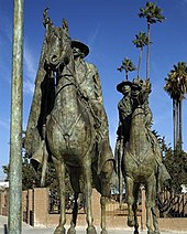
A statue of Thomas Fallon also met strong resistance from those who called him largely responsible for the decimation of early native populations. Chicano/Latino activists protested because he had captured San Jose by military force in the Mexican–American War (1846). They also protested the perceived "repression" of historic documents detailing Fallon's orders expelling many of the city's Californio (early Spanish/Mexican/Mestizo) residents. In October 1991 protests at Columbus Day and Dia de la Raza celebrations stalled than plan, and the statue was stored in a warehouse in Oakland for more than a decade. The statue returned in 2002 to a less conspicuous location: Pellier Park, a small triangular patch at the merge of West Julian and West St. James streets.[167]
In 2001, the city-sponsored SharkByte, an exhibit of decorated sharks based on the mascot of the hockey team, the San Jose Sharks, and modeled after Chicago's display of decorated cows.[168] Large models of sharks decorated in clever, colorful, or creative ways by local artists were displayed for months at dozens of locations around the city. After the exhibition, the sharks were auctioned off for charity.
In 2006, Adobe Systems commissioned an art installation titled San Jose Semaphore by Ben Rubin,[169] at the top of its headquarters building. Semaphore is composed of four LED discs which "rotate" to transmit a message. The content remained a mystery until it was deciphered in August 2007.[170][171] The visual art installation is supplemented with an audio track, transmitted from the building on a low-power AM station. The audio track provides clues to decode the message being transmitted.
San Jose retains a number of murals in the Chicano history tradition of Diego Rivera and José Clemente Orozco of murals as public textbooks.[172]
Although intended to be permanent monuments to the city's heritage as a mission town founded in 1777, a number of murals have been painted over, notably Mural de la Raza, on the side of a Story Rd shoe store, and Mexicatlan at the corner of Sunset and Alum Rock. In addition, two of three murals by Mexican artist Gustavo Bernal Navarro have disappeared.[172] The third mural, La Medicina y la Comunidad at the Gardner clinic on East Virginia Street, depicts both modern and traditional healers.[172]
Surviving Chicano history murals include Nuestra Senora de Guadelupe at Our Lady of Guadalupe church and the 1970s or 1980s Virgen de Guadelupe Huelga Bird at Cal Foods east of downtown. The Guadalajara restaurant has the 1986 Guadalajara Market No. 2 by Edward Earl Tarver III and a 2013 work by Jesus Rodriguez and Empire 7, La Gran Culture Resonance.[172]
An unknown artist painted the Huelga Bird and Aztec City mural in the 1970s or 1980s on the Clyde L. Fisher Middle School. In 1995 Antonio Nava Torres painted The Aztec Calendar Handball Court at Biebrach Park, and the unknown artist of Chaco's Pachuco painted it on the former Chaco's Restaurant in the 1990s. The Jerry Hernandez mural by Frank Torres at Pop's Mini Mart on King Road dates to 2009, and another recent mural by Carlos Rodriguez on the Sidhu Market at Locust and West Virginia depicts a stern-looking warrior.[172]
Performing arts
[edit]
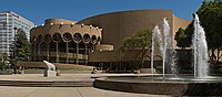
The city is home to many performing arts companies, including Opera San Jose, Symphony Silicon Valley, Ballet San Jose Silicon Valley, sjDANCEco, The San Jose Symphonic Choir, Children's Musical Theater San Jose,[173] the San Jose Youth Symphony, the San Jose Repertory Theatre, City Lights Theatre Company, The Tabard Theatre Company, San Jose Stage Company, and the now-defunct American Musical Theatre of San Jose which was replaced by Broadway San Jose in partnership with Team San Jose. San Jose is also home to the San Jose Museum of Art,[174] one of the nation's premiere Modern Art museums.
The SAP Center at San Jose is one of the most active venues for events in the world. According to Billboard Magazine and Pollstar, the arena sold the most tickets to non-sporting events of any venue in the United States, and third in the world after the Manchester Evening News Arena in Manchester, England, and the Bell Centre in Montreal, Canada, for the period from January 1 – September 30, 2004.[175]
The annual Cinequest Film Festival in downtown has grown to over 60,000 attendees per year, becoming an important festival for independent films. The San Francisco Asian American Film Festival is an annual event, which is hosted in San Francisco, Berkeley, and Downtown San Jose. Approximately 30 to 40 films are screened in San Jose each year at the Camera 12 Downtown Cinemas. The San Jose Jazz Festival is another of many events hosted throughout the year.
The Ira F. Brilliant Center for Beethoven Studies houses the largest collection of Ludwig van Beethoven in the world, outside of Europe, and is the only institution of its kind in North America.
Sports
[edit]

| Club | Sport | Founded | League | Venue (capacity) |
|---|---|---|---|---|
| San Jose Sharks | Hockey | 1991 | National Hockey League | SAP Center (17,562) |
| San Jose Earthquakes | Soccer | 1995 | Major League Soccer | PayPal Park (18,000) |
| San Jose Barracuda | Hockey | 2015 | American Hockey League | Tech CU Arena (4,200) |
| San Jose Giants | Baseball | 1988 | California League | Excite Ballpark (4,200) |
| San Jose State Spartans | NCAA Football | 1893 | Mountain West Conference | CEFCU Stadium (21,520) |
San Jose is home to the San Jose Sharks of the NHL, the San Jose Barracuda of the AHL, and the San Jose Earthquakes of Major League Soccer. The Sharks and the Barracuda play in the SAP Center at San Jose. The Earthquakes built an 18,000 seat new stadium that opened in March 2015. San Jose was a founding member of both the California League and Pacific Coast League in minor league baseball. San Jose currently fields the San Jose Giants, a Low-A affiliate of the San Francisco Giants.
San Jose has been host to several U.S. Olympic team trials over the years. In 2004, the San Jose Sports Authority held the trials for judo, taekwondo, trampolining and rhythmic gymnastics at the San Jose State Event Center. SAP Center hosted the Gymnastic trials in 2012[176] and 2016 (women's only).[177] and the U.S. Figure Skating Championships (used in Olympic years to select the Olympians) in 1996, 2012, and 2018. It was due to host the 2021 Championship, but that was moved to Las Vegas and it will instead host 2023.[178] In 2008, around 90 percent of the members of the United States Olympic team were processed at San Jose State University prior to traveling to the 2008 Summer Olympics in Beijing.[179] The 2009 Junior Olympics for trampoline were also held here.
In August 2004, the San Jose Seahawk Rugby Football Club hosted the USA All-Star Rugby Sevens Championships at Watson Bowl, east of Downtown. San Jose State hosted the 2011 American Collegiate Hockey Association (ACHA) national tournament.[180] The NCAA Division I men's basketball tournament is also frequently held in San Jose.
From 2005 to 2007, the San Jose Grand Prix, an annual street circuit race in the Champ Car World Series, was held in the downtown area. Other races included the Trans-Am Series, the Toyota Atlantic Championship, the United States Touring Car Championship, the Historic Stock Car Racing Series, and the Formula D Drift racing competition.
In the 2010s, San Jose "aggressively wooed" the Oakland Athletics to relocate to San Jose from nearby Oakland, but the San Francisco Giants exercised a veto against this proposal.[181] In 2013, the city of San Jose sued Major League Baseball for not allowing the Athletics to relocate to San Jose.[182] On October 5, 2015, the United States Supreme Court rejected San Jose's bid on the Athletics, who in 2023 announced they would relocate to Las Vegas.[183]
Landmarks
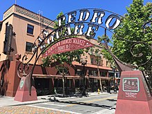
[edit]Notable landmarks in San Jose include Children's Discovery Museum of San Jose, History Park at Kelley Park, Cathedral Basilica of St. Joseph, Plaza de César Chávez, Dr. Martin Luther King, Jr. Library, Mexican Heritage Plaza, Rosicrucian Egyptian Museum, Lick Observatory, Hayes Mansion, SAP Center at San Jose, Hotel De Anza, San Jose Improv, Sikh Gurdwara of San Jose, Peralta Adobe, Excite Ballpark, Spartan Stadium, Japantown San Jose, Winchester Mystery House, Raging Waters, Circle of Palms Plaza, San Jose City Hall, San Jose Flea Market, Oak Hill Memorial Park, San Jose electric light tower, and The Tech Museum of Innovation.
-

-

-

-
-
-

-
-

-

-

-
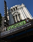
 The historic Sainte Claire Hotel, today The Westin San Jose
 -


Museums and institutions
[edit]

- The Tech Museum of Innovation
- Ira F. Brilliant Center for Beethoven Studies, which houses the largest collection of Ludwig van Beethoven in the world outside of Europe
- Dr. Martin Luther King, Jr. Library, the largest U.S. public library west of the Mississippi River
- San Jose Museum of Art, contemporary art museum with a collection of West Coast artists
- Children's Discovery Museum of San Jose
- History Park at Kelley Park
- Mexican Heritage Plaza, a Chicano museum and cultural center
- Movimiento de Arte y Cultura Latino Americana, is an inclusive contemporary arts museum grounded in the Chicano/Latino experience
- Portuguese Historical Museum
- Rosicrucian Egyptian Museum, the largest collection of Egyptian artifacts on display in the western United States, located at Rosicrucian Park
- San Jose East Carnegie Branch Library is notable as it is the last Carnegie library still operating in San Jose, and is on the National Register of Historic Places.
- San Jose Steam Railroad Museum, proposed, artifacts and rolling stock are kept at the fairgrounds and Kelley Park
- History San José
- Japanese American Museum of San Jose, a museum of Japanese-American history
- Old Bank of America Building, a historic landmark
- San Jose Museum of Quilts & Textiles, the first museum in America dedicated solely to quilts and textiles as an art form
- Viet Museum, a museum of Vietnamese-American history
Law and government
[edit]
Local
[edit]San Jose is a charter city under California law, giving it the power to enact local ordinances that may conflict with state law, within the limits provided by the charter.[184] The city has a council-manager government with a city manager nominated by the mayor and elected by the city council.
The San Jose City Council is made up of ten council members elected by district, and a mayor elected by the entire city. During city council meetings, the mayor presides, and all eleven members can vote on any issue. The mayor has no veto powers. Council members and the mayor are elected to four-year terms; the even-numbered district council members beginning in 1994; the mayor and the odd-numbered district council members beginning in 1996.[185] Each council member represents approximately 100,000 constituents.
Council members and the mayor are limited to two successive terms in office, although a council member that has reached the term limit can be elected mayor, and vice versa. The council elects a vice-mayor from the members of the council at the second meeting of the year following a council election. This council member acts as mayor during the temporary absence of the mayor, but does not succeed to the mayor's office upon a vacancy.[185]

The City Manager is the chief administrative officer of the city, and must present an annual budget for approval by the city council. When the office is vacant, the Mayor proposes a candidate for City Manager, subject to council approval. The council appoints the Manager for an indefinite term, and may at any time remove the manager, or the electorate may remove the manager through a recall election. Other city officers directly appointed by the council include the City Attorney, City Auditor, City Clerk, and Independent Police Auditor.[185] Like all cities and counties in the state, San Jose has representation in the state legislature.
Like all California cities except San Francisco, both the levels and the boundaries of what the city government controls are determined by the Local Agency Formation Commission (LAFCO).[186] The goal of a LAFCO is to try to avoid uncontrolled urban sprawl. The Santa Clara County LAFCO has set boundaries of San Jose's "Sphere of Influence" (indicated by the blue line in the map near the top of the page) as a superset of the actual city limits (the yellow area in the map), plus parts of the surrounding unincorporated county land, where San Jose can, for example, prevent development of fringe areas to concentrate city growth closer to the city's core. The LAFCO also defines a subset of the Sphere as an 'Urban Service Area' (indicated by the red line in the map), effectively limiting development to areas where urban infrastructure (sewers, electrical service, etc.) already exists.
San Jose is the county seat of Santa Clara County.[187] Accordingly, many county government facilities are located in the city, including the office of the County Executive, the Board of Supervisors, the District Attorney's Office, eight courthouses of the Superior Court, the Sheriff's Office, and the County Clerk.[188]
San Jose is protected by the San Jose Police Department and San Jose Fire Department. Drinking water is supplied by the San José Municipal Water System (Muni Water) along with the privately owned San Jose Water Company and Great Oaks Water Company. The San José–Santa Clara Regional Wastewater Facility provides advanced wastewater treatment and reclaimed water.
State and federal
[edit]
In the California State Senate, San Jose is split between the 10th, 15th, and 17th districts,[13] represented by Democrat Aisha Wahab, Democrat Dave Cortese, and Democrat John Laird respectively.
In the California State Assembly, San Jose is split between the 23rd, 24th, 25th, 26th, and 28th districts,[5] represented by Democrat Marc Berman, Democrat Alex Lee, Democrat Ash Kalra, Democrat Evan Low, and Democrat Gail Pellerin, respectively.
Federally, San Jose is split between California's 17th, 18th, and 19th congressional districts,[189] represented by Democrat Ro Khanna, Democrat Zoe Lofgren, and Democrat Jimmy Panetta, respectively.[190]
Several state and federal agencies maintain offices in San Jose. The city is the location of the Sixth District of the California Courts of Appeal.[191] It is also home to one of three courthouses of the United States District Court for the Northern District of California, the other two being in Oakland and San Francisco.[192]
Crime
[edit]Like most large cities, crime levels had fallen significantly after rising in the 1980s.[193] From 2002 to 2006, Morgan Quitno Press named San Jose the safest city in the United States with a population over 500,000 people.[194] Crime in San Jose had been lower than in other large American cities until 2013, when crime rates in San Jose climbed above California and U.S. averages.[195]
In 2021, SmartAsset ranked San Jose tied as the 10th safest city in the United States.[196] In 2020, violent crime per 100,000 people has been the lowest the city has seen in 2017 while the homicide rate has been the highest since 2016; property crime per 100,000 people has been the lowest the city has seen in over ten years.[197]
- 2021 mass shooting
On May 26, 2021, a mass shooting occurred at a Santa Clara Valley Transportation Authority (VTA) rail yard in San Jose. Ten people were killed, including the gunman, 57-year-old VTA employee Samuel James Cassidy, who shot and killed himself.[198][199][200][201] The shooting led to a day-long suspension of light rail services in the area.[202][203] It is the deadliest mass shooting in the history of the San Francisco Bay Area.[204]
In June 2021, roughly a month following the shooting, San Jose became the first city in the United States to require gun owners to carry liability insurance after a unanimous vote by the city council.[205]
Education
[edit]Higher education
[edit]


San Jose is home to several colleges and universities. The largest is San José State University, which was founded by the California legislature in 1862 as the California State Normal School, and is the founding campus of the California State University (CSU) system. Located in downtown San Jose since 1870, the university enrolls approximately 35,000 students in over 250 different bachelor's, master's and doctoral degree programs.[206]
The school enjoys a good academic reputation, especially in the fields of engineering, business, computer science, art and design, and journalism, and consistently ranks among the top public universities in the western region of the United States.[207] San Jose State is one of only three Bay Area schools that fields a Football Bowl Subdivision (FBS) Division I college football team; Stanford University and U.C. Berkeley are the other two.
California University of Management and Technology (CALMAT) offers many degree programs, including MBA, Computer Science, Information Technology. Most classes are offered both online and in the downtown campus. Many of the students are working professionals in the Silicon Valley.
The University of Silicon Valley is located in the Golden Triangle of North San Jose.
Lincoln Law School of San Jose and University of Silicon Valley Law School offer law degrees, catering to working professionals.
National University maintains a campus in San Jose.
The San Jose campus of Golden Gate University offers business bachelor and MBA degrees.
In the San Jose metropolitan area, Stanford University is in Stanford, California, Santa Clara University is in Santa Clara, California, and U.C. Santa Cruz is in Santa Cruz, California. Within the San Francisco Bay Area, other universities include U.C. Berkeley, U.C. San Francisco, U.C. Hastings College of Law, University of San Francisco, and California State University, East Bay.
The San Jose area's community colleges, San Jose City College, West Valley College, Mission College and Evergreen Valley College, offer associate degrees, general education units to transfer to CSU and UC schools, and adult and continuing education programs. The West campus of Palmer College of Chiropractic is also located in San Jose.
WestMed College is headquartered in San Jose and offers paramedic training, emergency medical technician training, and licensed vocational nursing programs.
The University of California operates Lick Observatory atop Mount Hamilton.
Western Seminary has one of its four campuses in San Jose, which opened on the campus of Calvary Church of Los Gatos in 1985. The campus relocated in 2010 to Santa Clara. Western is an evangelical, Christian graduate school that provides theological training for students who hope to serve in a variety of ministry roles including pastors, marriage and family therapists, educators, missionaries and lay leadership. The San Jose campus offers four master's degrees, and a variety of other graduate-level programs.[208]
National Hispanic University offered associate and bachelor's degrees and teaching credentials to its students, focusing on Hispanic students, until its closing in 2015.[209]
Начальное и среднее образование
[ редактировать ]До открытия средней школы Линкольна в 1943 году студенты Сан -Хосе посещали только среднюю школу Сан -Хосе . Сан -Хосе имеет 127 элементарных, 47 средних и 44 государственных средних школ.
Государственное образование в городе предоставляется четырьмя школьными округами, четырнадцатью начальными районами и тремя объединенными школьными округами (которые предоставляют как начальные, так и средние школы). [ 210 ]
- Объединенные школьные округа включают в себя: Сан -Хосе, доллар США (SJUSD), Morgan Hill USD и Санта -Клара USD
- Районы средней школы включают в себя: Campbell UHSD , East Side UHSD , Fremont UHSD и Los Gatos-Saratoga JUSD
- Районы начальной школы включают в себя: выпускной рок UESD , Berryessa UESD , Cambrian ESD , Campbell UESD , Cupertino UESD , Evergreen ESD , Franklin-McKinley ESD , Los Gatos , UESD Mount Lusther Moreland Burbank ESD , SD , Pleasan и Union ESD .
SJUSD объявил о банкротстве в 1983 году; В то время это был крупнейший школьный округ США, который объявил о банкротстве. [ 211 ] Наблюдатели определили причины в качестве падения 5000 учеников в предыдущие годы, трудности, связанные с школьными финансами Serrano v. Priest в 1968 году, сокращение налоговых денег из -за предложения калифорнийского предложения 1978 года и договора профсоюза местного учителя, требующего повышения в оплате. [ 212 ]
Частные школы в Сан -Хосе в основном управляются религиозными группами. [ Цитация необходима ] Католическая епархия Сан-Хосе имеет вторую по величине студенческую популяцию в округе Санта-Клара, позади только SJUSD; [ Цитация необходима ] Епархия и ее приходы управляют несколькими школами города, в том числе пять средних школ. [ 213 ] Другие частные религиозные школы баптистские , [ 214 ] Неподентационный протестант и Висконсин Синод Лютеранский . [ 215 ] Светские частные школы включают кембрийскую академию и школу Харкер .
Библиотеки
[ редактировать ]
Система публичной библиотеки Сан -Хосе уникальна тем, что библиотека доктора Мартина Лютера Кинга -младшего сочетает в себе коллекции городской системы с главной библиотекой государственного университета Сан -Хосе. В 2003 году строительство библиотеки, которая в настоящее время содержит более 1,6 миллиона предметов, было крупнейшим проектом по строительству единой библиотеки к западу от Миссисипи, с восемью этажами, которые приводят к более чем 475 000 кв. Футов (44 100 М 2 ) пространства с вместимостью на 2 миллиона томов. [ 216 ]
В городе есть 23 отделения соседства, включая Biblioteca latinoAmericana («Латинская американская библиотека»), которые специализируются на работах испанского языка. [ 217 ] Библиотека филиала Восточного Сан -Хосе Карнеги , библиотека Карнеги, открытая в 1908 году, является последней библиотекой Карнеги в округе Санта -Клара, все еще действующей в качестве публичной библиотеки и указана в Национальном реестре исторических мест . В результате показателя облигаций, принятой в ноябре 2000 года, ряд новых или полностью реконструированных филиалов были завершены и открыты. Также запланировано новая новая юго-восточная филиала, в результате чего планируется проект библиотеки облигаций. [ 218 ]
Система Сан -Хосе (наряду с университетской системой) была совместно названа «Библиотекой года» как « Библиотека года». в 2004 году [ 219 ]
Транспорт
[ редактировать ]Как и другие американские города, построенные в основном после Второй мировой войны, Сан-Хосе в зависимости от автомобиля в зависимости от автомобиля, и 76 процентов жителей водят в одиночку на работу, а в 2017 году-12 процентов. [ 220 ] Город поставил амбициозную цель - в 2009 году переключить моторизованные поездки на ходьбу, велосипед и общественный транспорт с принятием его общего плана San Jose 2040. В 2018 году город продлил эти цели до 2050 года благодаря своему умному плану Climate Climate San Jose. [ 221 ]
Общественный транспорт
[ редактировать ]
Железнодорожный сервис в Сан-Хосе предоставляется Amtrak Сакраменто-Сан-Жозе ( Капитолийский коридор и Сиэтл -Лос-Ангелес -Звездный свет ), Caltrain (Commuter Rail Service между Сан-Франциско и Гилрой ), Ace (Comper Rails The Pleasanton и Стоктон ), и местная система легкорельсовой железы VTA , соединяющую центр города с Маунтин -Вью , Милпитас , Кэмпбелл и Альмаден -Вэлли , управляется Управлением транспорта долины Санта -Клара (VTA). Исторические трамваи из исторического парка работают на линии скоростных железных дорог в центре города во время праздников.
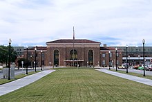
Долгосрочные планы призывают к Барта расширению до Санта-Клары со станции Берриесса/Северного Сан-Хосе . Первоначально расширение должно было быть построено одновременно, но из -за рецессии доходы от налога с продаж резко снизились. Из -за этого расширение будет построено в два этапа. Фаза 1 расширенная служба в Сан-Хосе с завершением станций Милпита и Берриесса Барт 13 июня 2020 года. Кроме того, Сан-Хосе станет главной остановкой на будущем высокоскоростного железнодорожного маршрута Калифорнии между Лос-Анджелесом и Сан-Франциско. [ 222 ] Станция Diridon (ранее Cahill Depot, 65 Cahill Street) является точкой встречи всех региональных пригородных железнодорожных служб в этом районе. [ 223 ] Он был построен в 1935 году Южной Тихоокеанской железной дорогой и был отремонтирован в 1994 году.
VTA также управляет множеством автобусных маршрутов в Сан -Хосе и окружающих общинах, а также предлагает услуги Paratransit местным жителям. Кроме того, автобусная линия Highway 17 Express соединяет центральный Сан -Хосе с Санта -Крус . Поставщики межготовых автобусов включают борзуе , Boltbus , Megabus , California Thfttle Bus , Tufesa , Intercalifornias , Hoang и Usasia . [ 224 ] Flixbus также обслуживает город с остановкой в 129 W San Carlos.
Воздух
[ редактировать ]
Сан-Хосе обслуживается международным аэропортом Нормана Й. Минета Сан-Хосе в двух миометрах (3,2 км) к северо-западу от центра города и аэропортом Рейд-Хиллвью в округе Санта-Клара , аэропорт общей авиации, расположенной в восточной части Сан-Хосе. Жители Сан -Хосе также используют международный аэропорт Сан -Франциско , крупный международный центр, расположенный 35 миль (56 км) на северо -западе, и международный аэропорт Сан -Франциско залив Окленд , еще один крупный международный аэропорт, расположенный 35 миль (56 км) на севере. Аэропорт также находится рядом с перекрестками трех основных автострадов, США 101 , I-880 и SR 87 .
Шоссе
[ редактировать ]Район Сан -Хосе обслуживается системой автострады, которая включает в себя три межгосударственные автострады и один маршрут США . Это, однако, самый большой город в стране, который не обслуживается первичным (одно- или двухзначным маршрутом . Большая часть сети межгосударственных шоссе была запланирована к началу 1950 -х годов задолго до быстрого роста Сан -Хосе десятилетиями спустя.
US 101 проходит на юг до центрального побережья Калифорнии и Лос -Анджелеса, а затем бежит на север вверх возле восточного берега полуострова Сан -Франциско в Сан -Франциско. I-280 также отправляется в Сан-Франциско, но идет к западу от городов полуострова Сан-Франциско. I-880 направляется на север в Окленд , проходя параллельно юго-восточному берегу залива Сан-Франциско . I-680 Parallels I-880 Фремонту , но затем перерезает северо-восток в восточные города района залива Сан-Франциско .

Несколько государственных автомагистралей также обслуживают Сан -Хосе: SR 17 , SR 85 , SR 87 и SR 237 . Кроме того, Сан-Хосе обслуживается системой скоростных автомагистралей по всему округу, которая включает в себя скоростную автомагистраль Almaden , скоростную автомагистраль Capitol , скоростную автомагистраль Сан-Томас и скоростную автомагистраль Лоуренса .
В последние годы были предприняты несколько региональных транспортных проектов, чтобы управлять заторами на автострадах Сан -Хосе. Это включает в себя расширение государственного маршрута 87, чтобы добавить больше полос движения возле района Сан -Хосе в центре города.
Обмен для I-280, соединяющего I-680 и US 101, был назван « Joe Colla Interchange» . [ 226 ]
Основные автомагистрали:
Велосипед
[ редактировать ]За последнее десятилетие в Центральном Сан-Хосе было постепенное расширение велосипедных дорожек, которые в настоящее время включают в себя сеть сети, разделенных в автомобиле, и забуференных велосипедных дорожек. Велосипедная вечеринка в Сан-Хосе -это ежемесячное мероприятие по социальному велосипеде, управляемое волонтерами, которое в течение летних месяцев привлекает до 1000 участников, чтобы «построить сообщество через велосипед». Менее одного процента жителей города ездят на велосипедах на работу [ 227 ] В качестве основного способа транспортировки статистика не изменилась за последние десять лет. Как правило, от 3 до 5 жителей поражены и убиты водителями автомобилей во время велосипеда на улицах Сан -Хосе каждый год. [ 228 ]
Примечательные люди
[ редактировать ]Сестринские города
[ редактировать ]У Сан -Хосе есть одна из старейших программ по сестринскому городу в стране. В 1957 году, когда город установил отношения с Окамой, Япония, это были лишь третьи отношения города в стране, которые начались в предыдущем году. Управление по экономическому развитию координирует программу Сан -Хосе Сестра -Сити, которая является частью International International . По состоянию на 2014 год [update], есть восемь городов -сестринских городов : [ 229 ] [ 230 ]
- Окама , Япония (основана 26 мая 1957 г.) [ 231 ]
- Сан -Хосе, Коста -Рика (1961)
- Веракруз , Мексика (1975)
- Тайнань , Тайвань (1977)
- Дублин , Ирландия (1986) [ 232 ]
- Yekaterinburg , Russia (1992)
- PUT , Индия (1992)
- Гвадалахара , Мексика (2014) [ 233 ] [ 234 ]
Смотрите также
[ редактировать ]Ссылки
[ редактировать ]- ^ «Калифорнийские города до даты включения» . Калифорнийская ассоциация местных комиссий по формированию . Архивировано из оригинала (слово) 3 ноября 2014 года . Получено 25 августа 2014 года .
- ^ "Правительство" . Сан -Хосе, Калифорния. Архивировано с оригинала 15 марта 2015 года . Получено 15 марта 2015 года .
- ^ «Городской совет» . Сан -Хосе, Калифорния. Архивировано из оригинала 16 декабря 2014 года . Получено 8 декабря 2014 года .
- ^ «Сан -Хосе, городской совет Калифорнии назначил Дженнифер Магуайр временного городского менеджера» . 13 июля 2021 года. 13 2021 Архивировал из оригинала 24 августа 2021 года . Получено 24 августа 2021 года .
{{cite news}}: Проверять|archive-url=ценность ( помощь ) - ^ Подпрыгнуть до: а беременный «Сообщества интересов - город» . Комиссия по перераспределению граждан Калифорнии. Архивировано с оригинала 23 октября 2015 года . Получено 10 октября 2014 года .
- ^ «Файлы газетчиков США 2019 года» . Бюро переписи Соединенных Штатов. Архивировано из оригинала 26 августа 2022 года . Получено 1 июля 2020 года .
- ^ "Сан -Хосе" . Географические имена информационная система . Геологическая служба США , Министерство внутренних дел США . Получено 11 января 2015 года .
- ^ Подпрыгнуть до: а беременный «Высоты и расстояния» . Геологическая служба США. 29 апреля 2005 года. Архивировано с оригинала 9 ноября 2013 года . Получено 10 февраля 2015 года .
- ^ Подпрыгнуть до: а беременный в дюймовый «QuickFacts: Сан -Хосе -Сити, Калифорния» . Бюро переписи Соединенных Штатов.
- ^ «Данные населения и жилищного государства 2020 года» . Перепись.gov . Бюро переписи Соединенных Штатов. Архивировано из оригинала 24 августа 2021 года . Получено 22 августа 2021 года .
- ^ «Поиск Zip (TM)» . Почтовая служба Соединенных Штатов . Архивировано с оригинала 16 ноября 2014 года . Получено 23 ноября 2014 года .
- ^ «Менеджер города Сан -Хосе Норберто Дуэнас снял временный тег» . Сан Хосе внутри . Метро газеты. 5 мая 2015 года. Архивировано с оригинала 7 мая 2015 года . Получено 5 мая 2015 года .
- ^ Подпрыгнуть до: а беременный «Сообщества интересов - город» . Комиссия по перераспределению граждан Калифорнии. Архивировано с оригинала 23 октября 2015 года . Получено 10 октября 2014 года .
- ^ Подпрыгнуть до: а беременный Городская хартия, принятая в 1965 году и в соответствии с поправками избирателей до февраля 2021 года . Город Сан -Хосе. Февраль 2021 г. [1965]. Раздел 100. Архивировано из оригинала 11 августа 2021 года . Получено 6 сентября 2021 года .
- ^ В изоляции SAN произносится Испанское произношение: [Сан] .
- ^ Джонс Томпсон, Мэринн (31 марта 2023 г.). «Это официально: четверть миллиона человек бежали из района залива с 2020 года» . Стандарт Сан -Франциско . Получено 18 декабря 2023 года .
- ^ «Столичные и микрополитические статистические районы. Общее количество населения: 2020-2022» . Перепись.gov . Получено 18 декабря 2023 года .
- ^ Подпрыгнуть до: а беременный "Сайт переписи США" . Бюро переписей США. Архивировано из оригинала 7 августа 2022 года . Получено 3 декабря 2019 года .
- ^ Блэр Роуэн, Гарриет; Грешлер, Габриэль; Prodis Sulek, Юлия (18 мая 2023 г.). «Сан -Хосе больше не в топ -10 из самых густонаселенных городов США» . Mercury News . Получено 20 мая 2023 года .
- ^ «Ежегодные оценки населения -резидента: с 1 апреля 2010 года по 1 июля 2018 года» . Бюро переписей Соединенных Штатов , Отдел населения. Апрель 2019 года. Архивировано с оригинала 13 февраля 2020 года . Получено 30 мая 2019 года .
- ^
- «Новое исследование: Сан -Хосе более разнообразен, чем Сан -Франциско» . 6 марта 2019 года. Архивировано с оригинала 24 января 2022 года . Получено 25 марта 2022 года .
- «Три города залива считались наиболее разнообразными в США» 14 октября 2019 года. Архивировано из оригинала 25 марта 2022 года . Получено 25 марта 2022 года .
- «Сан -Хосе составляет еще один список, включенный в 10 лучших городов 2018 года» . www.sjchamber.com . Архивировано с оригинала 7 апреля 2023 года . Получено 25 марта 2022 года .
- ^
- Zeveloff, J. (14 февраля 2013 г.). «10 самых дорогих городов в Соединенных Штатах» 7 мая 2016 года в The Wayback Machine Daily Finance. Получено 16 августа 2013 г.
- HSU, T. (20 сентября 2012 г.). «Самые богатые города Америки: перепись говорит Сан -Хосе, Сан -Франциско» . Los Angeles Times . Получено 16 августа 2013 года.
- Глинк, И. (22 февраля 2013 г.). «Самые богатые города Америки в 2013 году». Архивировано 8 марта 2017 года, на The Wayback Machine . Yahoo Finance. Получено 16 августа 2013 г.
- Басс, Ф., Хоман, Т. (18 октября 2011 г.). «Доходы Beltway делают нас капиталом богаче, чем Силиконовая долина», архивировав 29 июля 2014 года в The Wayback Machine . Блумберг. Получено 16 августа 2013 года.
- ^ Кеттманн, Стив (4 ноября 2005 г.). «36 часов в Сан -Хосе, Калифорния» . New York Times . Архивировано из оригинала 26 марта 2022 года . Получено 26 марта 2022 года .
- ^ "Где Силиконовая долина?" Полем Историческая ассоциация Силиконовой долины . Архивировано из оригинала 4 июля 2020 года . Получено 8 марта 2021 года .
- ^
- Дженкинс, А. Джаррод (19 апреля 2019 г.). «Дженкинс: Пришло время сбросить« столицу Силиконовой долины » . Сан -Хосе прожектор . Архивировано из оригинала 11 сентября 2021 года . Получено 10 сентября 2021 года .
- "Где Силиконовая долина?" Полем Историческая ассоциация Силиконовой долины . Архивировано из оригинала 4 июля 2020 года . Получено 8 марта 2021 года .
- ^ «Бизнес-журнал Silicon Valley-в районе Сан-Хосе есть третий по величине ВВП в мире на душу населения, говорит Брукингс» . Архивировано с оригинала 9 марта 2017 года . Получено 8 марта 2017 года .
- ^ Миллингтон, Элисон. «10 самых дорогих городов, которые будут жить во всем мире в 2017 году» . Бизнес -инсайдер . Архивировано из оригинала 26 марта 2022 года . Получено 26 марта 2022 года .
- ^ Нгуен, Бет (17 августа 2016 г.). «Сохранение вьетнамской традиции в Силиконовой долине» . Музей еды и напитков. Архивировано из оригинала 22 января 2022 года . Получено 20 апреля 2022 года .
- ^ Гэри, Джесси (20 сентября 2021 г.). «Сражение за многолетнюю проблему Силиконовой долины: инклюзивность среди латиноамериканских популяций» . KTVU FOX 2 . Архивировано из оригинала 26 марта 2022 года . Получено 26 марта 2022 года .
- ^ "Первый город" . История Калифорнии онлайн . Архивировано из оригинала 18 февраля 2008 года . Получено 15 марта 2008 года .
- ^ «Калифорнийский день входа - 9 сентября 1850 года» . Калифорнийские государственные парки . 2007. Архивировано из оригинала 28 марта 2016 года . Получено 15 марта 2008 года .
- ^ Подпрыгнуть до: а беременный «Перепись 1990 и 1980 гг. Считается населению городов с населением 1990 года более 100 000» . Бюро переписи Соединенных Штатов. Архивировано с оригинала 29 июня 2014 года . Получено 8 августа 2014 года .
1980 : Сан -Франциско = 678974, Сан -Хосе = 629400. 1990 : Сан -Хосе = 782248, Сан -Франциско = 723959
- ^ МакДермид, Райли (26 сентября 2017 г.). «Сан-Хосе обладает самой быстрорастущей экономикой в Калифорнии» . Силиконовая долина Business Journal . Архивировано из оригинала 19 августа 2018 года . Получено 27 сентября 2017 года .
- ^ Ли, Роланд; Резал, Адриана (17 мая 2023 г.). «Этот район залива больше не является одним из 10 крупнейших в США - загруженных городами во Флориде и Техасе» . Сан -Франциско Хроника .
- ^ Грей, В. Валланс; Гиффорд, С. (1869). Вид на птичьи глаза на город Сан -Хосе, Калифорния (карта). Сан -Хосе, Калифорния: Джордж Х. Хэйр - через Wikimedia Commons.
- ^ Monro-Fraser, JP, ed. (Август 1881 г.). История округа Санта -Клара, Калифорния . Alley, Bowen & Company. п. 344. Архивировано с оригинала 23 апреля 2023 года . Получено 7 сентября 2021 года - через Google Books.
В субботу, 15 декабря 1849 года, первый законодательный орган штата встретился в Сан -Хосе.
- ^ «Решение 44-136» . Вашингтон, округ Колумбия: Совет Соединенных Штатов по географическим именам. 11 декабря 1943 года. Архивировано с оригинала 29 августа 2021 года . Получено 28 августа 2021 года .
- ^ Purcell, John M.; Крофт, Джеймс А.; Монахан, Рич. Американские городские флаги (PDF) . Североамериканская весилологическая ассоциация . С. 320–321. Архивировано (PDF) из оригинала 29 августа 2021 года . Получено 1 мая 2020 года .
- ^ «S70-12 Острый акцент (é) помещен на« E »Сан-Хосе во всех письменных коммуникациях» (PDF) . Государственный колледж Сан -Хосе. 16 июня 1970 года. Архивировал (PDF) с оригинала 24 сентября 2021 года . Получено 28 августа 2021 года .
- ^ «Акцентный знак» . Напа, Калифорния: Регистр долины Напа . United Press International. 21 августа 1974 г. с. 17. Архивировано из оригинала 23 апреля 2023 года . Получено 29 августа 2021 года - через Newspapers.com.
- ^ Джонс, Джимми (23 августа 1974 г.). «Совет Сан -Хосе приказывает акцент» . Vallejo Times Herald . п. 6. Архивировано из оригинала 23 апреля 2023 года . Получено 29 августа 2021 года - через Newspapers.com.
- ^ «Салют поменялся» . Курьер-Журнал . Луисвилл, Кентукки. Ассошиэйтед Пресс. 30 августа 1974 г. с. A6 Архивировано из оригинала 23 апреля 2023 года . Получено 29 августа 2021 года - через Newspapers.com.
- ^ Город Сан -Хосе - Меморандум, использование официальной городской печати и двухсотлетнего логотипа, 5 апреля 1979 года (в офисе клерка Сити Сан -Хосе)
- ^ Городская хартия: фактически 4 мая 1965 года, с поправками . Город Сан -Хосе. 1964. с. 1. Архивировано из оригинала 23 апреля 2023 года . Получено 6 сентября 2021 года - через Google Books.
- ^ «Городская хартия, действующая в мае 1965 года, внесен в поправки в течение 1 февраля 2010 года» . Город Сан -Хосе. 1 февраля 2010 г. [1965]. Раздел 100. Архивировано из оригинала 6 сентября 2021 года . Получено 6 сентября 2021 года .
- ^ Гид города Сан -Хосе . Город Сан -Хосе. Июль 2000 г. с. 21. Архивировано из оригинала (PDF) 3 февраля 2017 года . Получено 5 февраля 2017 года .
- ^ «Руководство по формату меморандумы совета» (PDF) . Департамент общественных работ Сан -Хосе. Август 2016. С. 15. Архивировано из оригинала (PDF) 29 декабря 2016 года . Получено 5 февраля 2017 года .
- ^ «Сан -Хосе, Калифорния, официальный сайт» . Архивировано из оригинала 23 июля 2010 года . Получено 6 февраля 2014 года .
- ^ Для происхождения, прибытия и смещения на основе «лингвистических доказательств» в 500 г. н.э. за Леви, 1978: 486, также Бин, 1994: XXI (CITES Levy 1978). Для свиданий на кургане, FM Stanger 1968: 4.
- ^ Подпрыгнуть до: а беременный «Ранняя история» . Национальный реестр исторических мест . Архивировано из оригинала 9 июня 2007 года . Получено 5 июня 2007 года .
- ^ «Доистория» . 4 ноября 2013 года. Архивировано с оригинала 22 ноября 2017 года . Получено 23 ноября 2017 года .
- ^ Для событий 1795–1796, Милликен, 1995: 129–134 («Массовая миграция зимой 1794–95»). Для Runaways, Milliken, 1995: 97 (Cite Fages, 1971).
- ^ "Junípero Serra" . История Калифорнии онлайн . Калифорнийское историческое общество. 2000. Архивировано из оригинала 12 августа 2004 года . Получено 20 июня 2007 года .
- ^ Эдвард Ф. О'Дей (октябрь 1926 г.). «Основание Сан -Франциско» . Сан -Франциско вода . Управление водоснабжения весной долины. Архивировано с оригинала 27 июля 2010 года . Получено 7 февраля 2013 года .
- ^ Клайд Арбакл (1986). История Клайда Арбакл в Сан -Хосе . Смит Маккей Печать. ISBN 978-9996625220 .
- ^ «Испанский период» . Сан -Хосе История . Архивировано из оригинала 1 декабря 2017 года . Получено 23 ноября 2017 года .
- ^ «Испанские мексиканские записи Сан-Хосе Пуэбло: Pueblo Papers» . История Сан -Хосе . Архивировано из оригинала 1 декабря 2017 года . Получено 23 ноября 2017 года .
- ^ "Мексиканский период" . Сан -Хосе История . Архивировано из оригинала 1 декабря 2017 года . Получено 23 ноября 2017 года .
- ^ «1846–1869» . Сан -Хосе История . Архивировано с оригинала 22 ноября 2017 года . Получено 23 ноября 2017 года .
- ^ Маас, Гарольд (14 июля 1990 г.). «Латиноамериканцы Сан -Хосе Вой о планах« Статуи завоевания » » . Los Angeles Times . Архивировано из оригинала 11 мая 2021 года . Получено 1 октября 2020 года .
- ^ «Ранняя история» . Служба национальных парков США . 22 февраля 2018 года. Архивировано с оригинала 29 ноября 2020 года . Получено 1 октября 2020 года .
- ^ «История Капитолия штата Калифорния: часть 1» . Калифорнийский музей Капитолия . Архивировано с оригинала 16 ноября 2017 года . Получено 23 ноября 2017 года .
- ^ Clyde Arbuckle «История Сан -Хосе» (Smith & McKay, 1985), с. 27: «Поэтому, если потомство не может определить порядок, в котором губернатор подписал эти законопроекты, всегда будет вопрос о том, был ли Сан -Хосе, уже предшествующий Сакраменто, был вторым, третьим или четвертым городом Калифорнии».
- ^ Джордж Р. Стюарт, Калифорнийская тропа: Эпик со многими героями (Университет Небраски Пресс, 1962), с. 28
- ^ Ken McKowen & Dahlynn McKowen, Best of California's Missions, особняки и музеи (Wilderness Press, 2006), с. 77–99.
- ^ Первое государственное здание Капитолия Архивировано 1 декабря 2017 года в машине Wayback , исторической базе данных маркеров.
- ^ "Наше наследие - JBT" . Jbtcorporation.com. Архивировано с оригинала 5 июня 2016 года . Получено 15 мая 2019 года .
- ^ «Agnews безумно убежище» . Национальный реестр исторических мест . Архивировано из оригинала 24 мая 2007 года . Получено 7 июня 2007 года .
- ^ Подпрыгнуть до: а беременный в дюймовый и «Калифорния - гонка и латиноамериканское происхождение для отдельных городов и других мест: самая ранняя перепись 1990 года» . Бюро переписей США. Архивировано из оригинала 12 августа 2012 года . Получено 20 апреля 2012 года .
- ^ «Упаковка: Последний урожай Сан -Хосе, оставшийся в сельскохозяйственном заднице долины» . Mercury News . 25 июля 1999 года. Архивировано с оригинала 24 мая 2017 года . Получено 16 мая 2017 года .
- ^ Подпрыгнуть до: а беременный «Воспоминание: короткая политическая история Сан -Хосе» . Сан -Хосе Государственный университет. Архивировано из оригинала 7 июля 2008 года . Получено 9 ноября 2013 года .
- ^ «История систем BAE» . Архивировано из оригинала 20 февраля 2007 года . Получено 9 ноября 2013 года .
- ^ Бланкеншип, Уильям Д. (1971). «Рейнольд Б. Джонсон» . IBM . Архивировано из оригинала 4 мая 2019 года . Получено 8 сентября 2021 года .
- ^ Уинслоу, Уорд (редактор); Создание Силиконовой долины: столетняя ренессанс ; 1995; ISBN 0-9649217-0-7
- ^ «Пример из Сан-Хосе, часть первая: граница городского роста» . Институт Торо. Архивировано из оригинала 23 февраля 2007 года . Получено 7 июня 2007 года .
- ^ «История разрешений на строительство, 1980–2006» . Город Сан -Хосе. Архивировано из оригинала 27 сентября 2007 года . Получено 7 июня 2007 года .
- ^ Re Holdsworth; Страчан, Ра; Magloughlin, J.; Knipe, RJ (2001). Природа и тектоническое значение ослабления зоны разлома . Геологическое общество Лондона. п. 15. ISBN 978-1-86239-090-4 Полем Архивировано из оригинала 23 апреля 2023 года . Получено 20 ноября 2020 года .
- ^ Подпрыгнуть до: а беременный Саффорд, Пэт (17 ноября 2010 г.). «Наследие голландского хамана преследует жителей кембрийцев, фон аннексии» (PDF) . Кэмпбелл Экспресс . Тол. 59, нет. 45. с. 1. Архивировал (PDF) из оригинала 10 ноября 2013 года . Получено 9 ноября 2013 года .
- ^ Дон Маккормак (16 июля 1995 г.). «Сан -Хосе: реальность, а не репутация» . Sfgate . Архивировано с оригинала 10 ноября 2013 года . Получено 8 июля 2013 года .
- ^ Сакс, Аарон (январь -февраль 1999 г.). «Виртуальная экология - краткая история окружающей среды Силиконовой долины» (PDF) . Всемирное наблюдение . Worldwatch.org. п. 15. Архивировано (PDF) из оригинала 10 ноября 2013 года . Получено 9 ноября 2013 года .
- ^ «Голландский Хаманн - часть первой» . Сан Хосе внутри. 16 января 2006 г. Архивировано с оригинала 10 ноября 2013 года . Получено 8 июля 2013 года .
- ^ «Голландский Хаманн - часть вторая» . Сан Хосе внутри. 16 января 2006 г. Архивировано с оригинала 10 ноября 2013 года . Получено 8 июля 2013 года .
- ^ Дэвид Кимп; Леда Патмор; C. Майкл Хоган; Гарри Сейдман; Vivian Paparigian (1976). Окончательный отчет о воздействии на окружающую среду, Альмаден Парк Quicksilver. Департамент парков и отдыха округа Санта -Клара (отчет).
- ^ «Тонущее состояние» . Государственный университет Сан -Франциско . Апрель 1996 г. Архивировано с оригинала 15 апреля 2012 года . Получено 9 ноября 2013 года .
- ^ География Восточного региона, информационные услуги (29 апреля 2005 г.). «Высоты и расстояния» . Egsc.usgs.gov. Архивировано с оригинала 9 ноября 2013 года . Получено 21 октября 2014 года .
- ^ Городской совет Сан -Хосе (1 марта 1983 г.). «Наружное освещение на частных разработках» (PDF) . Архивировано из оригинала (PDF) 2 июля 2006 года . Получено 18 июня 2007 года .
- ^ «UCSC, обсерватория LICK назначает астероид для города Сан -Хосе» . Калифорнийский университет, Санта -Крус . 25 мая 1998 года. Архивировано с оригинала 17 августа 2007 года . Получено 18 июня 2007 года .
- ^ Джули Филлипс; Райан Филлипс; Нила Шринивасан; Дебора Асо; Венди Лао; Пэт Корнели (2012). Безопасный проход для Койот -Вэлли: связь дикой природы для коридора 101 (PDF) (отчет). Купертино, Калифорния: Колледж де Анза . Архивировано из оригинала (PDF) 27 сентября 2013 года . Получено 26 января 2019 года .
- ^ [1] Архивировано 3 мая 2022 года, на машине Wayback "Андерсон водохранилище будет близко к публике до 2030 года". Доступ 30 марта 2022 года.
- ^ [2] Архивировано 3 мая 2022 года, на машине Wayback «Водохранилище Андерсон осушило до 3 процентов». Доступ 31 марта 2022 года.
- ^ «Некоторым жителям Сан -Хосе может быть вода к лету, если засуха продолжится, говорит эксперт» . ABC7 News . Архивировано из оригинала 8 августа 2022 года . Получено 3 июня 2022 года . [ Название отсутствует ]
- ^ Подпрыгнуть до: а беременный «Таблица 1 Обзор классов климата Кёппен-Гейгера, включая определяющие критерии» . Природа .
- ^ Мигель Миллер. «Климат Сан -Хосе» . Национальная служба погоды. Архивировано из оригинала 15 декабря 2004 года . Получено 18 июня 2007 года .
- ^ "Сан -Хосе Месяц погода" . Accuweather. Архивировано с оригинала 17 ноября 2011 года.
- ^ Служба, национальная погода NOAA. «Глоссарий - Национальная служба погоды NOAA» . W1.Weather.gov . Архивировано из оригинала 9 июля 2021 года . Получено 3 июля 2021 года .
- ^ «Молния вызывает многочисленные пожары в районе залива, горы Санта -Крус» . MSN . Архивировано из оригинала 9 июля 2021 года . Получено 3 июля 2021 года .
- ^ «Cal Fire: Czu Lightning Complex, извлеченные уроки - пожарный дикойрья» . 4 мая 2021 года. Архивировано с оригинала 9 июля 2021 года . Получено 3 июля 2021 года .
- ^ «Ежемесячный общий снегопад (дюймы)» . Западный региональный климат -центр. 24 июля 2006 г. Архивировано с оригинала 29 июня 2014 года . Получено 12 июня 2013 года .
- ^ «Резюме ежемесячных норм 1991–2020» . Национальное управление океанического и атмосферного. Архивировано из оригинала 13 мая 2021 года . Получено 13 мая 2021 года .
- ^ «Nowdata - данные о погоде NOAA» . Национальное управление океанического и атмосферного . Архивировано из оригинала 18 апреля 2019 года . Получено 27 февраля 2019 года .
- ^ «Парк выпускников» , архивные 16 марта 2014 года в машине Wayback в городе Сан -Хосе . Получено 9 июля 2013 года.
- ^ «Рейтинги Паркскора 2013 года архивировали 22 июля 2013 года в The Wayback Machine » The Thust для общественной земли », полученного 9 июля 2013 года.
- ^ «Монополия в парке» . www.monopolyinthepark.com . Архивировано с оригинала 24 декабря 2015 года . Получено 23 декабря 2015 года .
- ^ «Фарм -парк Эммы Пруш» . Парки, отдых и услуги по соседству . Город Сан -Хосе. Архивировано из оригинала 10 марта 2005 года . Получено 9 ноября 2013 года .
- ^ «Полевой спортивный парк» . sccgov.org . Архивировано из оригинала 21 июля 2014 года . Получено 18 июня 2014 года .
- ^ «Городские и соседские рейтинги» . Прогулка. 2011. Архивировано из оригинала 19 сентября 2012 года . Получено 28 августа 2011 года .
- ^ «Таблица статуса сети» (PDF) . Город Сан -Хосе. 30 января 2008 года. Архивировал (PDF) из оригинала 8 апреля 2008 года . Получено 31 марта 2008 года .
- ^ Лейди, Ра; Г.С. Беккер; Bn Harvey (2005). «Историческое распределение и текущий статус Steelhead/Rainbow Frout (Oncorhynchus mykiss) в потоках устья устья Сан -Франциско, Калифорния» (PDF) . Центр управления и восстановления экосистем, Окленд, Калифорния. Архивировано из оригинала (PDF) 25 июля 2011 года . Получено 21 октября 2012 года .
- ^ "Чинук лосося" . Национальная служба морского рыболовства NOAA - популяция лосося - Чинук. Архивировано из оригинала 11 сентября 2010 года . Получено 13 сентября 2010 года . [ неудачная проверка ]
- ^ «Чувствительные виды рыб в биорегионе горов Санта -Крус» . Санта -Крус Биорегиональный Совет. 2004. Архивировано из оригинала 29 июня 2010 года . Получено 21 октября 2012 года .
- ^ Грег Керекс (14 ноября 2011 г.). «Гуадалупе реки Король лосось лосось под мостом Джулиан -стрит, осень, 2011 год» . YouTube . Архивировано из оригинала 2 февраля 2013 года . Получено 21 октября 2012 года .
- ^ Лен Рамирес (24 января 2019 г.). «Tule Elk сделает замечательное возвращение на юге Сан -Хосе -Хиллз» . Архивировано с оригинала 26 января 2019 года . Получено 26 января 2019 года .
- ^ «Койот -долина жизненно важна как коридор дикой природы» . Sfgate . Архивировано с оригинала 9 ноября 2017 года . Получено 9 ноября 2017 года .
- ^ Лаура Хаутала (1 января 2009 г.). "КОКСИНГА ДОЛЖЕНИЯ Койот" . Бэй природа . Архивировано с оригинала 28 сентября 2013 года . Получено 26 января 2019 года .
- ^ «Население восстанавливается для многих городов на северо -востоке и Среднем Западе» . 16 мая 2024 года . Получено 29 мая 2024 года .
- ^ «Перепись населения и жилья» . Перепись.gov. Архивировано из оригинала 1 июля 2021 года . Получено 4 июня 2015 года .
- ^ «Ежегодные оценки населения резидентов для включенных мест: с 1 апреля 2010 года по 1 июля 2014 года» . Архивировано из оригинала 23 мая 2015 года . Получено 4 июня 2015 года .
- ^ «Что стоит за недавним сокращением населения Калифорнии - и почему это важно» . Институт государственной политики Калифорнии . Получено 13 ноября 2023 года .
- ^ Подпрыгнуть до: а беременный «Сан -Хосе (город), Калифорния» . Штат и округ QuickFacts . Бюро переписей США. Архивировано из оригинала 2 сентября 2012 года . Получено 20 апреля 2012 года .
- ^ «P004: латиноамериканцы или латиноамериканцы, а не латиноамериканцы или латиноамериканцы по гонке - 2000: Сводка декабря 1 - Сан -Хосе -Сити, Калифорния» . Бюро переписи Соединенных Штатов . Получено 26 января 2024 года .
- ^ «P2: латиноамериканцы или латиноамериканцы, а не латиноамериканцы или латиноамериканцы по расе-2010: DEC перераспределение данных (PL 94-171)-Сан-Хосе-Сити, Калифорния» . Бюро переписи Соединенных Штатов . Получено 26 января 2024 года .
- ^ «P2: латиноамериканцы или латиноамериканцы, а не латиноамериканцы или латиноамериканцы по гонке-2020: DEC перераспределение данных (PL 94-171)-Сан-Хосе-Сити, Калифорния» . Бюро переписи Соединенных Штатов . Получено 26 января 2024 года .
- ^ «Поиск интерактивного населения 2010 года: CA - Сан -Хосе -Сити» . Бюро переписей США. Архивировано из оригинала 15 июля 2014 года . Получено 12 июля 2014 года .
- ^ "Сайт переписи США" . Бюро переписи Соединенных Штатов . Архивировано из оригинала 7 августа 2022 года . Получено 31 января 2008 года .
- ^ «Сан-Хосе, Калифорния: доходы за последние 12 месяцев (в 2007 году доллары с поправкой на инфляцию)» . Мы искатель фактов . Бюро переписей США. Архивировано с оригинала 24 ноября 2011 года.
- ^ Подпрыгнуть до: а беременный «ВВП по столичной области | Бюро экономического анализа США (BEA)» . www.bea.gov . Архивировано с оригинала 26 октября 2019 года . Получено 16 августа 2018 года .
- ^ «Сан -Хосе, Калифорния - официальный сайт - зона внешней торговли» . www.sanjoseca.gov . Архивировано из оригинала 1 декабря 2017 года . Получено 27 ноября 2017 года .
- ^ Штаб -квартира Samsung America (DS) Аархивирована 17 июля 2013 года на машине Wayback . Nbbj. Получено 21 июля 2013 года.
- ^ «Samsung Semiconductor» . www.samsung.com . Архивировано с оригинала 30 марта 2016 года . Получено 2 апреля 2016 года .
- ^ «Информационный бюллетень: профиль сообщества: занятость и работодатели» (PDF) . Город Сан -Хосе. 10 мая 2010 г. Архивировано из оригинала (PDF) 4 мая 2011 года . Получено 14 марта 2011 года .
- ^ "Acer - свяжитесь с нами" . Acer America. Архивировано с оригинала 22 октября 2013 года . Получено 10 ноября 2013 года .
- ^ «Свяжитесь с Netcom» . Netcom. Архивировано с оригинала 27 апреля 1999 года . Получено 7 сентября 2010 года .
- ^ Хелм, Лесли (25 марта 1997 г.). «Финансовый стол - Netcom, чтобы установить ограничения по времени на использование интернета»; Полем Los Angeles Times . п. D1. Архивировано с оригинала 1 ноября 2011 года . Получено 7 сентября 2010 г. - через Pqarchiver .
Наметить новое направление для поставщиков денег, потери интернет-услуг, онлайн-услуг по коммуникациям Netcom, базирующейся в Сан-Хосе ...
- ^ Подпрыгнуть до: а беременный Донато-Вайнштейн, Натан. «Эксклюзив: Apple покупает огромный сайт разработки в Сан -Хосе» . Силиконовая долина Business Journal . Архивировано из оригинала 3 апреля 2019 года . Получено 9 апреля 2021 года .
- ^ «Apple устанавливает сцену для кампуса Сан -Хосе с 15 000 работников» . www.mercurynews.com . 3 августа 2015 года. Архивировано с оригинала 22 ноября 2015 года . Получено 23 октября 2015 года .
- ^ «2012 Американское обследование сообщества» . Архивировано из оригинала 1 июля 2014 года.
- ^ «Самые богатые округа в Соединенных Штатах» . Архивировано из оригинала 19 апреля 2017 года . Получено 18 апреля 2017 года .
- ^ «У округа Санта -Клара самый высокий средний доход домохозяйства в стране, но разрыв богатства расширяется» . Mercury News . 10 августа 2014 года. Архивировано с оригинала 19 апреля 2017 года . Получено 18 апреля 2017 года .
- ^ «Первый город США, где средние дома стоят более 1 миллиона долларов» . Бизнес -инсайдер . Архивировано с оригинала 9 марта 2017 года . Получено 8 марта 2017 года .
- ^ Коломатски, Майкл (17 июня 2021 года). «Где находятся дома на миллион долларов? - В новом отчете показано, какие столичные районы США имеют самый высокий процент домов, оцениваемых в 1 миллион долларов или более» . New York Times . Архивировано из оригинала 28 декабря 2021 года . Получено 18 июня 2021 года .
- ^ «13 -й ежегодный обзор доступности по доступности Демографии: 2017» (PDF) . Архивировано (PDF) из оригинала 23 января 2013 года . Получено 8 марта 2017 года .
- ^ Перейра, Алисса (23 января 2017 г.). «Сан -Хосе - самый« недоступный »основной рынок жилья в США, говорится в опросе» . Sfgate . Архивировано с оригинала 9 марта 2017 года . Получено 8 марта 2017 года .
- ^ Кейт Спрингер. «Наименее доступные места для жизни в 2017 году» . CNN . Архивировано из оригинала 19 мая 2017 года . Получено 21 мая 2017 года .
- ^ «Десять наиболее и наименее дорогие городские районы в Аккре Стоимость жизни (COLI) - второй квартал 2004 года» . FedC.com. Архивировано с оригинала 9 сентября 2004 года . Получено 9 ноября 2013 года .
- ^ «Сан -Хосе - награды» . «Самые пригодные для жизни сообщества» (Партнеры для общественных сообществ, Вашингтон, округ Колумбия). Архивировано из оригинала 26 февраля 2011 года . Получено 7 апреля 2008 года .
- ^ «Сан -Хосе, столица Силиконовой долины: Сообщество № 1 для новаторов в США». Город Сан -Хосе. 27 марта 2008 года. Архивировано с оригинала 2 марта 2004 года . Получено 7 апреля 2008 года .
- ^ «Самый пригодный для жизни Америки: Сан -Хосе, Калифорния» . Архивировано с оригинала 6 ноября 2006 года . Получено 9 ноября 2013 года .
- ^ «Сан -Хосе: Откроется патентное управление США» . Mercury News . 15 октября 2015 года. Архивировано с оригинала 24 мая 2017 года . Получено 21 мая 2017 года .
- ^ «Силиконовая долина США патент и торговая марка» . www.uspto.gov . Архивировано с оригинала 2 июня 2016 года . Получено 5 июня 2016 года .
- ^ «Групповые митинги в штаб-квартире Google предъявляют требования к SJ Mega-Campus» . Пластырь. 12 апреля 2018 года. Архивировано с оригинала 27 апреля 2018 года . Получено 26 апреля 2018 года .
- ^ Дженнифер Элиас (21 апреля 2023 года). «Mega-Campus San Jose на 80 акров Google приостановлен, поскольку компания считает экономическим замедлением» . CNBC . Архивировано из оригинала 22 апреля 2023 года . Получено 22 апреля 2023 года .
- ^ Кара Эйзенпресс (28 апреля 2023 г.). «Нью -Йорк ближе, чем когда -либо, чтобы победить район залива по технологиям» . Crain Communications . Получено 29 мая 2023 года .
- ^ Бюро статистики труда США (1 января 1990 г.). «Уровень безработицы в Сан-Хосе-Суннивейл-Санта-Клара, Калифорния (MSA)» . Фред, федеральный резервный банк Сент -Луиса . Архивировано из оригинала 3 декабря 2019 года . Получено 3 декабря 2019 года .
- ^ Луи, Дэвид (23 апреля 2018 г.). «Больше беспроводного широкополосного покрытия, поступающего в Сан -Хосе через легкие столбы» . ABC7 News. Архивировано из оригинала 8 августа 2021 года . Получено 8 августа 2021 года .
- ^ Цифровой/HDTV Television Sivic - SF Bay Area Aractived 16 апреля 2010 года на The Wayback Machine . Choisser.com. Получено 14 апреля 2011 года.
- ^ Марти Чик. «Радио KQW, Сан -Хосе» . МАРДА -МУЗЕЙ РАЙОН. Архивировано из оригинала 3 февраля 2007 года . Получено 18 июня 2007 года .
- ^ «2023 Годовой комплексный финансовый отчет» . п. 303 . Получено 4 июня 2024 года .
- ^ «Повестка дня персонала» (PDF) . Город Сан -Хосе. 15 ноября 2007 г. Архивировано из оригинала (PDF) 28 мая 2008 года . Получено 5 мая 2008 года .
- ^ «Службы разработки» . Город Сан -Хосе. 6 февраля 2006 года. Архивировано из оригинала 2 апреля 2008 года . Получено 5 мая 2008 года .
- ^ «Исторический район Сан -Хосе в центре города» . Служба национальных парков. Архивировано из оригинала 12 мая 2008 года . Получено 5 мая 2008 года .
- ^ «Политика зеленого здания» . 10 апреля 2007 года. Архивировано с оригинала 1 апреля 2008 года . Получено 5 мая 2008 года .
- ^ Йодерс, Джефф (1 ноября 2005 г.). «Ратуша Ричарда Мейера в Сан-Хосе: Лид или не в Лид» . Проектирование здания и строительство . Архивировано из оригинала 10 августа 2009 года . Получено 9 ноября 2013 года .
- ^ Ассоциация соседства Buena Vista (21 февраля 2012 г.). «Фотографии домов в Сан -Хосе, штат Калифорния, тогда и сейчас» . Архивировано с оригинала 10 ноября 2014 года . Получено 16 августа 2014 года .
- ^ Мэри Готшалк / Сан -Хосе Меркьюри Новости (26 августа 2010 г.). «Особняк, спроектированный Джулией Морган на Аламеда в Сан-Хосе, скоро станет офисным помещением» . Архивировано из оригинала 14 июня 2015 года . Получено 12 июня 2015 года .
- ^ «2006–2007 годы предлагается бюджет капитала» (PDF) . Город Сан -Хосе . Архивировано из оригинала (PDF) 22 августа 2006 года.
- ^ HERHOLD, Скотт (2 февраля 2011 г.). «Hershold: Я буду скучать по красным глазам племенного змея Сан -Хосе» . Сан -Хосе Меркьюри Новости . Архивировано с оригинала 25 января 2012 года . Получено 15 апреля 2011 года .
- ^ «Статуя Фэллона обнародована» . Силиконовая долина/Сан -Хосе . 20 сентября 2002 года. Архивировано с оригинала 14 марта 2005 года . Получено 18 июня 2007 года .
- ^ Джим Лафренер. «Чикагские коровы на параде» . Chicagotraveler.com. Архивировано с оригинала 24 сентября 2010 года . Получено 1 июля 2010 года .
- ^ Крис Солтер; Селларс, Питер (2010). Запутанный: технология и трансформация производительности . MIT Press. п. 342. ISBN 978-0-262-19588-1 Полем Архивировано из оригинала 23 апреля 2023 года . Получено 20 ноября 2020 года . -Via Google Books.
- ^ «Сан -Хосе Семфор - конкурс 2006 года - прошлый конкурс - как был взломан код» . Adobe.com. Архивировано из оригинала 21 октября 2012 года . Получено 10 ноября 2013 года .
- ^ «Декодирование семафора Сан -Хосе» (PDF) . Ушная студия. 14 августа 2007 года. Архивировано из оригинала (PDF) 4 марта 2012 года . Получено 9 ноября 2013 года .
- ^ Подпрыгнуть до: а беременный в дюймовый и Леонардо Кастанеда (16 декабря 2018 г.). «Исчезающие фрески Сан -Хосе:« Это похоже на уничтожение истории людей » . Сан-Хосе Меркурий-Ньюз . Bay Area News Group. п. А1.
- ^ «О CMT Сан -Хосе» . Cmtsj.org. Архивировано из оригинала 30 мая 2013 года . Получено 8 июля 2013 года .
- ^ «Музей искусств Сан -Хосе» . Музей искусств Сан -Хосе. Архивировано с оригинала 28 сентября 2014 года . Получено 1 июля 2010 года .
- ^ Веймерс, Ли (29 октября 2004 г.). «Кому нужны акулы ? Архивировано из оригинала 9 марта 2005 года . Получено 9 ноября 2013 года .
- ^ «Полевые поля для олимпийских испытаний в США - гимнастика в Сан -Хосе, Калифорния» . США гимнастика . 12 июня 2022 года. Архивировано с оригинала 20 февраля 2022 года . Получено 20 февраля 2022 года .
- ^ «Женские олимпийские испытания, Конгресс приводит сообщество гимнастики в Сан -Хосе на этой неделе» . США гимнастика . Архивировано из оригинала 20 февраля 2022 года . Получено 20 февраля 2022 года .
- ^ «Национальные фигуры, переезжающие из Сан -Хосе в Лас -Вегас» . AP News . 9 ноября 2020 года. Архивировано с оригинала 20 февраля 2022 года . Получено 20 февраля 2022 года .
- ^ Брюс Ньюман (24 июля 2008 г.). «Невидимые герои: олимпийцы в« блокировке »в SJSU по пути в Пекин» . Сан -Хосе Меркьюри Новости . Архивировано из оригинала 1 февраля 2015 года . Получено 29 июля 2008 года .
- ^ «Сан -Хосе штата Спартансская история команды» . sjsuhockey.net. 2010. Архивировано из оригинала 12 октября 2010 года . Получено 4 мая 2010 года .
- ^ «Как складывается планы на стадион А» . Сан -Хосе Меркьюри Новости . Архивировано с оригинала 26 апреля 2013 года . Получено 18 августа 2013 года .
- ^ «Сан -Хосе делает большие качели в бейсболе Высшей лиги» . Архивировано с оригинала 24 июня 2013 года . Получено 17 октября 2014 года .
- ^ «Верховный суд США отвергает предложение Сан -Хосе заманить Окленд А» . Сан -Франциско Хроника . Архивировано из оригинала 6 октября 2015 года . Получено 5 октября 2015 года .
- ^ «Список калифорнийских чартерных городов» . Книга списков планировщиков Калифорнии . Калифорнийский губернаторский офис планирования и исследований. 1999. Архивировано из оригинала 8 февраля 2007 года . Получено 9 июня 2007 года .
- ^ Подпрыгнуть до: а беременный в "Сан -Хосе Сити Чартер" . Sanjoseca.gov. Архивировано с оригинала 12 января 2010 года . Получено 1 июля 2010 года .
- ^ «Комиссия по формированию местного агентства» . Santaclara.lafco.ca.gov. Архивировано с оригинала 12 февраля 2018 года . Получено 1 июля 2010 года .
- ^ «Хартия графства Санта -Клара, статья 101» (PDF) . Санта -Клара округ. Архивировано из оригинала (PDF) 6 ноября 2007 года . Получено 16 февраля 2008 года .
- ^ «Округ Санта -Клара контакты» . Архивировано из оригинала 21 января 2013 года . Получено 16 февраля 2008 года .
- ^ «Сообщества интересов - город» . Комиссия по перераспределению граждан Калифорнии. Архивировано с оригинала 30 сентября 2013 года . Получено 27 сентября 2014 года .
- ^ «17 -й округ Конгресса в Калифорнии - представители и районная карта» . Civic Impulse, LLC . Получено 13 марта 2013 года .
- ^ «Апелляционные суды: шестой округ Сан -Хосе» . Калифорнийские государственные суды. Архивировано из оригинала 22 июля 2010 года . Получено 16 февраля 2008 года .
- ^ «Информация суда: Сан -Хосе» . Окружной суд США по округу Северной Калифорнии. Архивировано из оригинала 11 февраля 2008 года . Получено 16 февраля 2008 года .
- ^ «Отчеты о форме преступности ФБР» .
- ^ «SJPD усилия по поддержанию самого безопасного статуса большого города» (PDF) . Город Сан -Хосе. 11 сентября 2007 года. Архивировал (PDF) из оригинала 28 августа 2021 года . Получено 28 августа 2021 года .
- ^ «Уровень преступности в Сан -Хосе превосходит среднее значение по США, аресты резко упали» . Mercury News . 16 декабря 2013 года. Архивировано с оригинала 18 декабря 2013 года . Получено 25 декабря 2013 года .
- ^ Гейер, Бен (7 апреля 2021 года). «Самые безопасные города в Америке - 2021 издание» . Smartasset. Архивировано из оригинала 28 августа 2021 года . Получено 28 августа 2021 года .
- ^ «Статистика преступности - годовая» . Полицейское управление Сан -Хосе. Архивировано из оригинала 28 августа 2021 года . Получено 28 августа 2021 года .
- ^ Геккер, Джоселин; Мендоса, Марта (26 мая 2021 г.). «Власти ID 8 Жертвы Калифорнии Railyard стрельба» . Ассошиэйтед Пресс . Архивировано из оригинала 26 мая 2021 года . Получено 26 мая 2021 года .
- ^ «Борьба, полицейская поиск по подозреваемому в Сан -Хосе VTA Yard Mass Shooting» . NBC Bay Area. 26 мая 2021 года. Архивировано из оригинала 26 мая 2021 года . Получено 26 мая 2021 года .
- ^ Рорлих, Джастин (26 мая 2021 года). «Стрелок в массовой стрельбе в Сан -Хосе опознал как сотрудник Сэмюэль Кэссиди» . Daily Beast. Архивировано из оригинала 26 мая 2021 года . Получено 26 мая 2021 года .
- ^ «Массовая стрельба оставляет 8 мертвых на VTA Yard в Сан -Хосе» . NBC Bay Area. 26 мая 2021 года. Архивировано из оригинала 26 мая 2021 года . Получено 26 мая 2021 года .
- ^ Левенсон, Эрик; Чан, Стелла; Моссбург, Чери; Мерфи, Пол П. (26 мая 2021 г.). «Стрелок, который убил восемь коллег на California Transit Facility хорошо знал жертв, говорит мэр» . CNN. Архивировано из оригинала 26 мая 2021 года . Получено 26 мая 2021 года .
- ^ Шапиро, Эмили; Перейра, Иван (26 мая 2021 г.). «Сотрудники подозреваемого среди 8 выстрела до смерти в Калифорнийском транзитном учреждении» . ABC News. Архивировано из оригинала 26 мая 2021 года . Получено 26 мая 2021 года .
- ^ Слога, Мэгги; Вулфолк, Джон; Толедо, Альдо; Сулек, Джулия Продис; Салонга, Роберт; Зеленый, Джейсон (26 мая 2021 г.). «Жертвы, стрелок опознал в самой смертельной массовой стрельбе в области залива» . Mercury News . Сан -Хосе, Калифорния. Архивировано из оригинала 26 мая 2021 года . Получено 26 мая 2021 года .
- ^ Торн, Дэн (30 июня 2021 г.). «Сан -Хосе становится 1 -й городом в Калифорнии, чтобы пройти широкие реформы оружия» . Крон4 . Архивировано из оригинала 2 июля 2021 года . Получено 30 июня 2021 года .
- ^ «Майоры и программы» . Сан -Хосе Государственный университет . Архивировано из оригинала 12 января 2023 года . Получено 8 февраля 2023 года .
- ^ «Рейтинги государственного университета Сан -Хосе» . США новости . US News и World Report. Архивировано из оригинала 3 февраля 2023 года . Получено 8 февраля 2023 года .
- ^ «Западная семинария Сан -Хосе кампус» . www.westernseminary.edu. Архивировано из оригинала 2 декабря 2013 года . Получено 26 ноября 2013 года .
- ^ «Национальный латиноамериканский университет» . Национальный латиноамериканский университет. Архивировано из оригинала 24 мая 2017 года . Получено 19 мая 2017 года .
- ^ «Перепись 2020 года - Справочная карта школьного округа: округ Санта -Клара, Калифорния» (PDF) . Бюро переписей США . С. 1-4 (PDF стр. 2-5/5) . Получено 5 сентября 2024 года . - текстовый список
- ^ «Школы Сан -Хосе могут сократить оплату, правила суда о банкротстве США» . New York Times . United Press International . 30 августа 1983 г. с. B8
- ^ Харди, Чарльз (сентябрь 1983). «Судья поддерживает банкротство в Сан -Хосе, но школы открываются вовремя» . Неделя образования . Архивировано из оригинала 11 сентября 2021 года . Получено 10 сентября 2021 года .
- ^ «Школы» . Римско -католическая епархия Сан -Хосе в Калифорнии . Архивировано из оригинала 27 сентября 2007 года . Получено 18 июня 2007 года .
- ^ «Берегасная школа- христианская школа, Сан-Хосе, Калифорния» . Christianschoolsanjose.org. Архивировано из оригинала 23 апреля 2023 года . Получено 19 января 2014 года .
- ^ "Aspire. Учитесь. Успех" . Архивировано из оригинала 6 августа 2020 года . Получено 23 апреля 2020 года .
- ^ Библиотека SJ MLK История библиотеки Кинг Архивирована 29 сентября 2013 г. на The Wayback Machine (упоминает об совместном университете/статусе города, размере сбора и размере проекта строительства.)
- ^ Страница локаций на сайте библиотеки SJ Архивирована 28 сентября 2013 г., на The Wayback Machine (см. Статью BL для ее ссылок.)
- ^ «Бонд -проекты для страницы библиотеки филиала на сайте библиотеки SJ» . Sjlibrary.org. Архивировано из оригинала 13 июня 2010 года . Получено 1 июля 2010 года .
- ^ Сан -Хосе 2003–2004 годовой отчет Архивируется 14 мая 2012 года, на машине Wayback «В 2004 году публичная библиотека Сан -Хосе и библиотека Государственного университета Сан -Хосе были совместно названы библиотечкой библиотеки журналом».
- ^ «Таблица S0801. Помещающие характеристики по полу, 2013–2017 годы Обследование американского сообщества 5-летние оценки (Сан-Хосе, Калифорния), Бюро переписей США» . Бюро переписи Соединенных Штатов . 2017. Архивировано с оригинала 7 августа 2022 года . Получено 13 декабря 2018 года .
- ^ Deruy, Эмили (15 февраля 2018 г.). «Сан -Хосе представляет новый климатический план» . Mercury News . Архивировано из оригинала 16 декабря 2018 года . Получено 13 декабря 2018 года .
- ^ Голл, Дэвид (13 марта 2009 г.). «Барт-сан Хосе планировщики на долгое время» . Сан -Хосе бизнес -журнал . Архивировано с оригинала 14 ноября 2009 года . Получено 13 марта 2009 г.
- ^ Мигель, Кен; Лим, Дион (23 апреля 2019 г.). «Высокоскоростная железная дорога Центральной долины может помочь решить жилье в области залива, кризис трудоустройства» . ABC7 Сан -Франциско . Архивировано с оригинала 23 апреля 2019 года . Получено 23 апреля 2019 года .
- ^ «Айбра - найти станцию» . Архивировано с оригинала 26 апреля 2015 года . Получено 2 мая 2015 года .
- ^ «SJC Сан-Хосе пролетает мимо SFO на вершину рейтинга в качестве лучшего аэропорта Америки» . Силиконовая долина Business Journal . Архивировано из оригинала 17 мая 2017 года . Получено 2 ноября 2017 года .
- ^ «Ассамблея параллельное разрешение № 102 - Joe Colla Interchange» . Законодательное собрание штата Калифорния. 30 августа 2010 года. Архивировано с оригинала 10 ноября 2013 года . Получено 10 ноября 2013 года .
- ^ «Таблица S0801, поездка на работу по сексу, 2012–2017 гг. Обследование американского сообщества для Сан -Хосе, Калифорния» . Бюро переписей США . 31 декабря 2018 года. Архивировано с оригинала 7 августа 2022 года . Получено 22 мая 2015 года .
- ^ «Опасные дороги Bay Area: фатальные аварии выросли на 43 процента с 2010 по 2016 год» . Mercury News . 8 декабря 2017 года. Архивировано с оригинала 1 января 2019 года . Получено 1 января 2019 года .
- ^ «Программа Сестрин -Сити» . Город Сан -Хосе. Архивировано из оригинала 24 мая 2017 года . Получено 19 марта 2014 года .
- ^ «Программа Pacific соседей Сан -Хосе Сестринские города» . Архивировано из оригинала 19 августа 2018 года . Получено 13 февраля 2012 года .
- ^ «Северная и центральная Калифорнийская сестринские города в Японии» . Архивировано с оригинала 26 октября 2019 года . Получено 15 июня 2019 года .
- ^ «Программа Сан-Джозе-Публин Сестрин-Сити» . Архивировано из оригинала 21 июля 2019 года . Получено 13 февраля 2012 года .
- ^ «Сан -Хосе и Пуна празднуют отношения с родственным городом с поднятием флага национального дня независимости Индии» . Архивировано из оригинала 30 мая 2013 года . Получено 17 февраля 2013 года .
- ^ «Сан -Хосе Сестринские города» . Архивировано из оригинала 5 мая 2013 года . Получено 17 февраля 2013 года .
Дальнейшее чтение
[ редактировать ]- Бейльхарц, Эдвин А.; и Демерс -младший, Дональд О.; Сан -Хосе: первый город Калифорнии ; 1980, ISBN 0-932986-13-7
- Калифорнийская комната архивировала 10 ноября 2013 года в The Wayback Machine , коллекции исследовательских материалов в библиотеке Сан -Хосе по истории Сан -Хосе и долины Санта -Клара.
Внешние ссылки
[ редактировать ] Определения из Wiktionary
  СМИ из Commons
  Новости от Wikinews
  Цитаты из Wikiquote
  Тексты из Wikisource
  Учебники из Wikibooks
  Ресурсы из Wikiversity
  Информация о путешествиях от Wikivoyage
- Официальный сайт

- Посетите Сан -Хосе , официальный туристический сайт
- Торговая палата Сан -Хосе
- Сан -Хосе в Керли
- Округ Санта -Клара: историческая Силиконовая долина Калифорния , Служба национальных парков
- Поздний вид Сан-Хосе с веб-камеры Маунт Гамильтон


- Сан -Хосе, Калифорния
- 1777 заведения в Альта -Калифорнии
- 1850 заведения в Калифорнии
- Города в округе Санта -Клара, штат Калифорния
- Города в районе залива Сан -Франциско
- Места округа в Калифорнии
- Бывшие государственные столицы в Соединенных Штатах
- Включенные города и города в Калифорнии
- Заселенные места, установленные в 1777 году
- Силиконовая долина
- Заселенные прибрежные места в Калифорнии