Хайбер-Пахтунхва


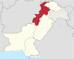
Хайбер-Пахтунхва ( пушту : خېبر پښتونخوا [ˈxebaɾ paxtunˈxwɑ] ; хинди и урду : خیبر پختونخوا , произносится [ˈxɛːbəɾ pəxˈtuːnxwɑː] ; сокр. КП ), ранее известная как Северо-Западная пограничная провинция СЗПП), — провинция Пакистана ( . Хайбер-Пахтунхва, расположенная в северо-западном регионе страны, является четвертой по величине провинцией Пакистана по площади и третьей по величине провинцией по численности населения. Он граничит с пакистанскими провинциями Белуджистан на юге, Пенджаб на юго-востоке, территорией Гилгит-Балтистан на севере и северо-востоке, столичной территорией Исламабад на востоке и Азад Кашмир на северо-востоке. он граничит с Афганистаном . На западе Хайбер-Пахтунхва имеет разнообразный ландшафт: от суровых горных хребтов, долин, равнин, окруженных холмами, до холмистых предгорий и густонаселенных сельскохозяйственных ферм.
Хотя это третья по величине провинция Пакистана как по численности населения, так и по экономике , географически она является самой маленькой. [ 5 ] В провинции проживает 17,9 процента всего населения Пакистана . Провинция многонациональна, основными этническими группами являются пуштуны , хиндковцы , сараики и читрали . [ 6 ] [ 7 ]
Когда-то Хайбер-Пахтунхва была оплотом буддизма и является местом расположения древнего региона Гандхара , включая руины столицы Гандхары Пушкалавати (расположенной недалеко от современной Чарсадды ). История региона характеризуется частыми вторжениями различных империй, во многом из-за его географической близости к исторически важному Хайберскому перевалу . [ 8 ]
Although it is colloquially known by a variety of other names, the name "Khyber Pakhtunkhwa" was brought into effect for the North-West Frontier Province in April 2010, following the passing of the 18th Constitutional Amendment. On 24 May 2018, the National Assembly of Pakistan voted in favour of the 25th Constitutional Amendment, which merged the FATA as well as the Provincially Administered Tribal Areas into Khyber Pakhtunkhwa.[9] The Provincial Assembly of Khyber Pakhtunkhwa subsequently approved the bill on 28 May 2018;[10] it was signed into law on 31 May by erstwhile Pakistani president Mamnoon Hussain, which officially completed the administrative merger process.[11][12]
Etymology
[edit]Khyber Pakhtunkhwa means the "Khyber side of the land of the Pashtuns,[13]" where the word Pakhtunkhwa means "Land of the Pashtuns",[14] while according to some scholars, it refers to "Pashtun culture and society".[15] The province has had various names throughout history. Other names used or proposed for the province include Gandhara, Afghania, Pashtunistan, Pathanistan, Sarhad, Abaseen, Khyber,[16][17] or a combination of names, such as Hazara-Pakhtunkhwa.[18][19]
When the British established it as a province, they called it "North West Frontier Province" (abbreviated as NWFP) until 2010 due to its relative location being in the northwest of the British Indian Empire.[20] After the creation of Pakistan, Pakistan continued with this name but a Pashtun political party, Awami National Party based in the province demanded that the province name be changed to "Pakhtunkhwa".[21] Their logic behind that demand was that Punjabi people, Sindhi people and Baloch people have their provinces named after their ethnicities but that is not the case for Pashtun people.[22]
Pakistan Muslim League (N), the largest opposition party at the time was ready to change the province's name by supporting the ruling Pakistan Peoples Party and ANP, in a constitutional amendment but wanted to name the province something other than which does not carry only the Pashtun identity in it as they argued that there were other minor communities living in the province especially the Hazarewals of the Hazara region who spoke Hindko thus the word Khyber was introduced with the name because it is the name of a major pass which connects Pakistan to Afghanistan.[22]
North-West Frontier Province
[edit]For over a hundred years after its founding as a province of British Raj in 1901, it was known as the North-West Frontier Province (abbreviated as NWFP) until 2010 due to its relative location being in the northwest of the nation.[23] Unofficially, it was known as Sarhad (Urdu: سرحد), derived from the province's Urdu name given to it by the Mughals, which means "frontier".
Efforts to change the name
[edit]For most of the history of the North-West Frontier Province (NWFP), there were efforts to change its name. The name Afghania was proposed first by the founding leaders of the Muslim League in 1933 and was at least partly chosen to represent the first "a" in "Pakistan". The need for a change was explained by the man who named Pakistan in his "Now or Never" pamphlet, Choudhary Rahmat Ali Khan, as:
"North-West Frontier Province" is semantically non-descript and socially wrongful. It is non-descript because it merely indicates their geographical situation as a province of old "British India" [which no longer exists]. It is wrongful because it suppresses the social entity of these people. In fact, it suppresses that entity so completely that when composing the name "Pakistan" for our homelands, I had to call the North-West Frontier Province the Afghan Province.[24]
Suggestions for new names came and went. Although some of the names were ethnically neutral, most proposals emphasised the province's Pashtun ethnic identity. The renaming issue was an emotional one which often crossed party lines and not all supporters of a renaming agreed on the name Pakhtunkhwa.
20th-century efforts
[edit]By the late 20th century, President Muhammad Zia-ul-Haq agreed with Khan Abdul Ghaffar Khan to change the name to Pashtunistan but he contended that the term Pashtunistan had become controversial and was being politicized by Afghanistan. Ghaffar Khan suggested Pakhtunkhwa, but Zia-ul-Haq asked Ghaffar Khan to suggest an alternative.[25]
The name Pakhtunkhwa was approved by the democratically elected constitutional assembly of the province in 1997 by majority vote.[26] However, the PML (N) parliamentary party of NWFP rejected the ANP demand but called for Prime Minister Nawaz Sharif to suggest another "non-controversial" name.[26] PML (N) members noted that Sarhad was a good name for the province but, if a change was needed, then it should be named Khyber or Abasin.[26] The NWFP chief minister, Sardar Mehtab Ahmed Khan, called for a referendum on the issue as a way of determining the name.[26] These offers were rejected by the ANP leadership and the ANP withdrew from both the federal and provincial governments.[26]
21st-century efforts
[edit]The lack of support for a name change by the PML (N) was defended as opposition to the nationalistic politics being pursued by the ANP.[27]
In May 2008, to accommodate a demand by the people of NWFP who voted for the ANP, the PPP proposed that the name of the North-West Frontier Province be changed to Pakhtunkhwa,[28][29] however the Muslim League Nawaz which had considerable support in the Hindko-speaking Hazara region of the province announced it might oppose the name change because of it "being on ethnic grounds" because of opposition by its provincial leadership, yet the party fails to explain the fact that the names of the other three provinces (Punjab, Sindh and Baluchistan) represent the ethnic identity of their majority populace, despite how they camouflage that fact with their version of the history of those provinces.[30]
The name Pakhtunkhwa was mentioned for the first time in the United Nation's General Assembly by Pakistani President Asif Zardari on 26 September 2008.[31]
Khyber Pakhtunkhwa
[edit]The Pashtun nationalist Awami National Party based in the province demanded that the province name be changed to "Pakhtunkhwa".[32] Their logic behind that demand was that Punjabi people, Sindhi people and Baloch people have their provinces named after their ethnicities but that is not the case for Pashtun people.[22]
Pakistan Muslim League (N), the largest opposition party at the time was ready to change the province's name by supporting the ruling Pakistan Peoples Party and ANP, in a constitutional amendment but wanted to name the province something other than which does not carry only the Pashtun identity in it as they argued that there were other minor communities living in the province especially the Hazarewals of the Hazara region who spoke Hindko thus the word Khyber was introduced with the name because it is the name of a major pass which connects Pakistan to Afghanistan.[22]
In early 2010, the process of renaming proceeded and the Pakistani Senate confirmed the name change to Khyber Pakhtunkhwa in the 18th amendment to the Constitution of Pakistan with a unanimous 90 votes on 15 April 2010.[33]
Renaming controversy
[edit]The name change of the province was met with strong opposition from the people of Hazara region and protests erupted in the region with wheel and shutter jam strikes. Abbottabad became the nerve center of the movement. On the 10th of April, the Khyber Pakhtunkhwa Police fired at unarmed protesters, leaving 7 dead and dozens injured.[34] Allegedly, the firing was ordered by the coalition government of Khyber Pakhtunkhwa, led by the Awami National Party.[35] This is one of the earliest incidents of police brutality in Pakistan in recent years, occurring before the Model Town Lahore incident, whose FIR has not been registered still today.[36]
Arif Nizami, former editor of The Nation, said, "This has actually opened a Pandora's box, because of Pakistan's very tenuous polity. Now, on one side, there are identity issues and ethnic issues and provincial autonomy issues. The other side is religious issues and terrorism. It's a very explosive situation."[37]
Alternative proposed names
[edit]Many alternative names were proposed for the province. Many of these alternatives were designed to avoid or balance the ethnic connotations of Pakhtunkhwa.[16][17]
Gandhara
[edit]The name Gandhāra was proposed by Pakistan Muslim League (N), as a neutral name for the province.[17][38][39] Gandhara was an ancient Indo-Aryan[40] civilization centered in the present-day province.[41][42][43] The core of the region of Gandhara was the Peshawar valley and Swat valley, though the cultural influence of "Greater Gandhara" extended across the Indus river to the Taxila region in Potohar Plateau and westwards into the Kabul valley in Afghanistan, and northwards up to the Karakoram range.[44][45][46]
It was attested in the Rigveda,[47][48] and it was one of the 16 Mahajanapadas of the second urbanisation.[41][42][43] The region was a major centre for Greco-Buddhism under the Indo-Greeks and Gandharan Buddhism under later dynasties, including Indo-Scythians, Indo-Parthians and Kushans. Gandhara was also a central location for the spread of Buddhism to Central Asia and East Asia.[49]
Gāndhārī, an Indo-Aryan language written in Kharosthi script, acted as lingua franca of the region.[50] Famed for its unique Gandharan style of art which is influenced by the classical Hellenistic styles, Gandhara attained its height from the 1st century to the 5th century CE under the Kushan Empire, who had their capital at Peshawar (Puruṣapura).
Hazara-Pakhtunkhwa
[edit]Some Hazara residents said that the new name should be Hazara-Pakhtunkhwa (in reference to the Hazara region where Hindko-speakers are dominant as compared to the Pashto-speakers elsewhere in the province),[51][11] and others said the name should not be changed since the people were accustomed to North-West Frontier Province.[37]
Other names
[edit]- Abaseen (Urdu: اباسین): from the Pashto name for the Indus River.[52][53][17]
- Khyber: from the Khyber Pass.[52][53][17]
History
[edit]Early history
[edit]During the times of Indus Valley civilisation (3300 BCE – 1700 BCE) the Khyber Pass through Hindu Kush provided a route to other neighbouring empires and was used by merchants on trade excursions.[54] From 1500 BCE, Indo-Iranian peoples started to enter in the region from Central Asia after having passed the Khyber Pass.[55][56]
The region of Gandhara, which was primarily based in the area of modern-day Khyber Pakhtunkhwa features prominently in the Rigveda (c. 1500 – c. 1200 BCE),[57][48] as well as the Zoroastrian Avesta, which mentions it as Vaēkərəta, the sixth most beautiful place on earth created by Ahura Mazda. It was one of the 16 Mahajanapadas of Vedic era.[58][59][60] It was the centre of Vedic and later forms of Hinduism. Gandhara was frequently mentioned in Vedic epics, including Rig Veda, Ramayana and Mahabharata. It was the home of Gandhari, the princess of Gandhara Kingdom.[61]
Alexander's conquests
[edit]In the spring of 327 BC Alexander the Great crossed the Hindu Kush and advanced to Nicaea, where Omphis, king of Taxila and other chiefs joined him. Alexander then dispatched part of his force through the valley of the Kabul River, while he himself advanced into Bajaur and Swat with his light troops.[62] Craterus was ordered to fortify and repopulate Arigaion, probably in Bajaur, which its inhabitants had burnt and deserted. Having defeated the Aspasians, from whom he took 40,000 prisoners and 230,000 oxen, Alexander crossed the Gouraios (Panjkora) and entered the territory of the Assakenoi and laid siege to Massaga, which he took by storm. Ora and Bazira (possibly Bazar) soon fell. The people of Bazira fled to the rock Aornos, but Alexander made Embolima (possibly Amb) his base, and attacked the rock from there, which was captured after a desperate resistance. Meanwhile, Peukelaotis (in Hashtnagar, 17 miles (27 km) north-west of Peshawar) had submitted, and Nicanor, a Macedonian, was appointed satrap of the country west of the Indus.[63]
Mauryan rule
[edit]
Mauryan rule began with Chandragupta Maurya displacing the Nanda Empire, establishing the Mauryan Empire. A while after, Alexander's general Seleucus had attempted to once again invade the subcontinent from the Khyber pass hoping to take lands that Alexander had conquered, but never fully absorbed into this empire. Seleucus was defeated and the lands of Aria, Arachosia, Gandhara, and Gedrosia were ceded to the Mauryans in exchange for a matrimonial alliance and 500 elephants. With the defeat of the Greeks, the land was once more under Hindu rule.[64] Chandragupta's son Bindusara further expanded the empire. However, it was Chandragupta's grandson Ashoka, who converted to Buddhism and made it the official state religion in Gandhara and also Pakhli, the modern Hazara, as evidenced by rock-inscriptions at Shahbazgarhi and Mansehra.[63]
After Ashoka's death the Mauryan empire fell to pieces, just as in the west the Seleucid power was waning.
Indo-Greeks
[edit]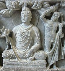
The Indo-Greek king Menander I (reigned 155–130 BCE) drove the Greco-Bactrians out of Gandhara and beyond the Hindu Kush, becoming king shortly after his victory.
His empire survived him in a fragmented manner until the last independent Greek king, Strato II, disappeared around 10 CE. Around 125 BCE, the Greco-Bactrian king Heliocles, son of Eucratides, fled from the Yuezhi invasion of Bactria and relocated to Gandhara, pushing the Indo-Greeks east of the Jhelum River. The last known Indo-Greek ruler was Theodamas, from the Bajaur area of Gandhara, mentioned on a 1st-century CE signet ring, bearing the Kharoṣṭhī inscription "Su Theodamasa" ("Su" was the Greek transliteration of the Kushan royal title "Shau" ("Shah" or "King")).
It is during this period that the fusion of Hellenistic and South Asian mythological, artistic and religious elements becomes most apparent, especially in the region of Gandhara.[citation needed]
Local Greek rulers still exercised a feeble and precarious power along the borderland, but the last vestige of the Greco-Indian rulers were finished by a people known to the old Chinese as the Yeuh-Chi.[63]
Indo-Scythian Kingdom
[edit]
The Indo-Scythians were descended from the Sakas (Scythians) who migrated from Central Asia into South Asia from the middle of the 2nd century BCE to the 1st century BCE. They displaced the Indo-Greeks and ruled a kingdom that stretched from Gandhara to Mathura. The first Indo-Scythian king Maues established Saka hegemony by conquering Indo-Greek territories.[66] The power of the Saka rulers declined after the defeat to Chandragupta II of the Gupta Empire in the 4th century.[67]
Indo-Parthian Kingdom
[edit]
The Indo-Parthian Kingdom was ruled by the Gondopharid dynasty, named after its first ruler Gondophares. For most of their history, the leading Gondopharid kings held Taxila (in the present Punjab province of Pakistan) as their residence, but during their last few years of existence the capital shifted between Kabul and Peshawar. These kings have traditionally been referred to as Indo-Parthians, as their coinage was often inspired by the Arsacid dynasty, but they probably belonged to a wider groups of Iranic tribes who lived east of Parthia proper, and there is no evidence that all the kings who assumed the title Gondophares, which means "Holder of Glory", were even related.
Kushan Empire
[edit]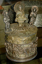
The Yuezhi nomads had driven the Sakas from the highlands of Central Asia, and were themselves forced southwards by the nomadic Xiongnu. One group, known as the Kushan, took the lead, and its chief, Kadphises I, seized vast territories extending south to the Kabul valley. His son Kadphises II conquered North-Western India, which he governed through his generals. His immediate successors were the fabled Hindu kings: Kanishka, Huvishka, and Vasushka or Vasudeva, of whom the first reigned over a territory which extended as far east as Benares, far south as Malwa, and also including Bactria and the Kabul valley.[63][68] Their dates are still a matter of dispute, but it is beyond question that they reigned early in the Christian era. To this period may be ascribed the fine statues and bas-reliefs found in Gandhara and Udyana. Under Huvishka's successor, Vasushka, the dominions of the Kushan kings shrank.[68]
Shahi dynasties
[edit]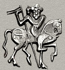
The Turk Shahis ruled Gandhara until 870, when they were overthrown by the Hindu Shahis. The Hindu Shahis are believed to belong to the Uḍi/Oḍi tribe, namely the people of Oddiyana (modern Swat) in Gandhara,[70][71] although they are also variously stated to be Brāhmāns or Kshātriyas.[72]
The first king Kallar had moved the capital into Udabandhapura from Kabul, in the modern village of Hund for its new capital.[73][74][75][76] At its zenith, the kingdom stretched over the Kabul Valley, Gandhara and western Punjab under Jayapala.[77] Jayapala saw a danger in the consolidation of the Ghaznavids and invaded their capital city of Ghazni both in the reign of Sebuktigin and in that of his son Mahmud, which initiated the Muslim Ghaznavid and Hindu Shahi struggles.[78] Sebuk Tigin, however, defeated him, and he was forced to pay an indemnity.[78] Jayapala defaulted on the payment and took to the battlefield once more.[78] Jayapala however, lost control of the entire region between the Kabul Valley and Indus River.[79]
In the year 1001, soon after Sultan Mahmud came to power and was occupied with the Qarakhanids north of the Hindu Kush, Jaipal attacked Ghazni once more and upon suffering yet another defeat by the powerful Ghaznavid forces, near present-day Peshawar. After the Battle of Peshawar, he died because of regretting as his subjects brought disaster and disgrace to the Shahi dynasty.[78][79]
Jayapala was succeeded by his son Anandapala,[78] who along with other succeeding generations of the Shahiya dynasty took part in various unsuccessful campaigns against the advancing Ghaznvids but were unsuccessful. The Hindu rulers eventually exiled themselves to the Kashmir Siwalik Hills.[79]
Ghaznavids
[edit]After the battle of Peshawar, Mahmud of Ghazni had secured controlled over southern regions of Pakhtunkhwa. He also (1024 and 1025) raided the Pashtuns.[68] [80] His descendants reigned till 1179, when Muhammad of Ghor took Peshawar, making it part of his expanding Ghurid Empire.
Delhi sultanate
[edit]Following the invasion by the Ghurids, five unrelated heterogeneous dynasties ruled over the Delhi Sultanate sequentially: the Mamluk dynasty (1206–1290), the Khalji dynasty (1290–1320), the Tughlaq dynasty (1320–1414), the Sayyid dynasty (1414–1451), and the Lodi dynasty (1451–1526).[81]
Meanwhile, the Pashtuns now appeared as a political factor. At the close of the fourteenth century they were firmly established in their present-day demographics south of Kohat, and in 1451 Bahlol Lodi's accession to the throne of Delhi gave them a dominant position in Northern India. Yusufzai tribes from the Kabul and Jalalabad valleys began migrating to the Valley of Peshawar beginning in the 15th century,[82] and displaced the Swatis of the Bhittani confederation and Dilazak Pashtun tribes across the Indus River to Hazara Division.[82]
Mughal empire
[edit]
Mughal suzerainty over the Khyber Pakhtunkhwa region was partially established after Babar, the founder of the Mughal Empire, invaded the region in 1505 CE via the Khyber Pass. The Mughal Empire noted the importance of the region as a weak point in their empire's defences,[83] and determined to hold Peshawar and Kabul at all cost against any threats from the Uzbek Shaybanids.[83]
He was forced to retreat westwards to Kabul but returned to defeat the Lodis in July 1526, when he captured Peshawar from Daulat Khan Lodi,[84] though the region was never considered to be fully subjugated to the Mughals.[82]
Under the reign of Babar's son, Humayun, a direct Mughal rule was briefly challenged with the rise of the Pashtun Emperor, Sher Shah Suri, who began construction of the famous Grand Trunk Road – which links Kabul, Afghanistan with Chittagong, Bangladesh over 2000 miles to the east. Later, local rulers once again pledged loyalty to the Mughal emperor.[citation needed]
Yusufzai tribes rose against Mughals during the Yusufzai Revolt of 1667,[83] and engaged in pitched-battles with Mughal battalions in Peshawar and Attock.[83] Afridi tribes resisted Aurangzeb rule during the Afridi Revolt of the 1670s.[83] The Afridis massacred a Mughal battalion in the Khyber Pass in 1672 and shut the pass to lucrative trade routes.[85] Following another massacre in the winter of 1673, Mughal armies led by Emperor Aurangzeb himself regained control of the entire area in 1674,[83] and enticed tribal leaders with various awards in order to end the rebellion.[83]
Referred to as the "Father of Pashto Literature" and hailing from the city of Akora Khattak, the warrior-poet Khushal Khan Khattak actively participated in the revolt against the Mughals and became renowned for his poems that celebrated the rebellious Pashtun warriors.[83]
On 18 November 1738, Peshawar was captured from the Mughal governor Nawab Nasir Khan by the Afsharid armies during the Persian invasion of the Mughal Empire under Nader Shah.[86][87]
Durrani Empire
[edit]
The area fell subsequently under the rule of Ahmad Shah Durrani, founder of the Durrani Empire,[88] following a grand nine-day long assembly of leaders, known as the loya jirga.[89] In 1749, the Mughal ruler was induced to cede Sindh, the Punjab region and the important trans Indus River to Ahmad Shah in order to save his capital from the Durrani attack.[90] Ahmad Shah invaded the remnants of the Mughal Empire a third time, and then a fourth, consolidating control over the Kashmir and Punjab regions. In 1757, he captured Delhi and sacked Mathura,[91] but permitted the Mughal dynasty to remain in nominal control of the city as long as the ruler acknowledged Ahmad Shah's suzerainty over Punjab, Sindh, and Kashmir. Leaving his second son Timur Shah to safeguard his interests, Ahmad Shah left India to return to Afghanistan.
Their rule was interrupted by a brief invasion of the Hindu Marathas, who ruled over the region following the 1758 Battle of Peshawar for eleven months till early 1759 when the Durrani rule was re-established.[92]
Under the reign of Timur Shah, the Mughal practice of using Kabul as a summer capital and Peshawar as a winter capital was reintroduced,[82][93] Peshawar's Bala Hissar Fort served as the residence of Durrani kings during their winter stay in Peshawar.
Mahmud Shah Durrani became king, and quickly sought to seize Peshawar from his half-brother, Shah Shujah Durrani.[94] Shah Shujah was then himself proclaimed king in 1803, and recaptured Peshawar while Mahmud Shah was imprisoned at Bala Hissar fort until his eventual escape.[94] In 1809, the British sent an emissary to the court of Shah Shujah in Peshawar, marking the first diplomatic meeting between the British and Afghans.[94] Mahmud Shah allied himself with the Barakzai Pashtuns, and amassed an army in 1809, and captured Peshawar from his half-brother, Shah Shujah, establishing Mahmud Shah's second reign,[94] which lasted under 1818.
Sikh Empire
[edit]Ranjit Singh invaded Peshawar in 1818 and captured it from the Durrani Empire. The Sikh Empire based in Lahore did not immediately secure direct control of the Peshawar region, but rather paid nominal tribute to Jehandad Khan of Khattak, who was nominated by Ranjit Singh to be ruler of the region.
After Ranjit Singh's departure from the region, Khattak's rule was undermined and power seized by Yar Muhammad Khan. In 1823, Ranjit Singh returned to capture Peshawar, and was met by the armies of Azim Khan at Nowshera. Following the Sikh victory at the Battle of Nowshera, Ranjit Singh re-captured Peshawar. Rather than re-appointing Jehandad Khan of Khattak, Ranjit Singh selected Yar Muhammad Khan to once again rule the region.
The Sikh Empire annexed the lower parts of Khyber Pakhtunkhwa region following advances from the armies of Hari Singh Nalwa. An 1835 attempt by Dost Muhammad Khan to re-occupy Peshawar failed when his army declined to engage in combat with the Dal Khalsa. Dost Muhammad Khan's son, Mohammad Akbar Khan engaged with Sikh forces the Battle of Jamrud of 1837, in which prominent sikh commander Hari Singh was killed.
During Sikh rule, an Italian named Paolo Avitabile was appointed an administrator of Peshawar in 1838, and is remembered for having unleashed a reign of fear there. The city's famous Mahabat Khan, built in 1630 in the Jeweller's Bazaar, was badly damaged and desecrated by the Sikhs, who also rebuilt the Bala Hissar fort during their occupation of Peshawar.
British Raj
[edit]
British East India Company defeated the Sikhs during the Second Anglo-Sikh War in 1849, and incorporated small parts of the region into the Province of Punjab. While Peshawar was the site of a small revolt against British during the Mutiny of 1857, local Pashtun tribes throughout the region generally remained neutral or supportive of the British as they detested the Sikhs,[56] in contrast to other parts of British India which rose up in revolt against the British. However, British control of parts of the region was routinely challenged by Wazir tribesmen in Waziristan and other Pashtun tribes, who resisted any foreign occupation until Pakistan was created. By the late 19th century, the official boundaries of Khyber Pakhtunkhwa region still had not been defined as the region was still claimed by the Kingdom of Afghanistan. It was only in 1893 The British demarcated the boundary with Afghanistan under a treaty agreed to by the Afghan king, Abdur Rahman Khan, following the Second Anglo-Afghan War.[95] Several princely states within the boundaries of the region were allowed to maintain their autonomy under the terms of maintaining friendly ties with the British. As the British war effort during World War One demanded the reallocation of resources from British India to the European war fronts, some tribesmen from Afghanistan crossed the Durand Line in 1917 to attack British posts in an attempt to gain territory and weaken the legitimacy of the border. The validity of the Durand Line, however, was re-affirmed in 1919 by the Afghan government with the signing of the Treaty of Rawalpindi,[96] which ended the Third Anglo-Afghan War – a war in which Waziri tribesmen allied themselves with the forces of Afghanistan's King Amanullah in their resistance to British rule. The Wazirs and other tribes, taking advantage of instability on the frontier, continued to resist British occupation until 1920 – even after Afghanistan had signed a peace treaty with the British.
British campaigns to subdue tribesmen along the Durand Line, as well as three Anglo-Afghan wars, made travel between Afghanistan and the densely populated heartlands of Khyber Pakhtunkhwa increasingly difficult. The two regions were largely isolated from one another from the start of the Second Anglo-Afghan War in 1878 until the start of World War II in 1939 when conflict along the Afghan frontier largely dissipated. Concurrently, the British continued their large public works projects in the region, and extended the Great Indian Peninsula Railway into the region, which connected the modern Khyber Pakhtunkhwa region to the plains of India to the east. Other projects, such as the Attock Bridge, Islamia College University, Khyber Railway, and establishment of cantonments in Peshawar, Kohat, Mardan, and Nowshera further cemented British rule in the region. In 1901, the British carved out the northwest portions of Punjab Province to create the Northwest Frontier Province (NWFP), which was renamed "Khyber Pakhtunkhwa" in 2010.[97]
During this period, North-West Frontier Province was a "scene of repeated outrages on Hindus."[98] During the independence period there was a Congress-led ministry in the province, which was led by secular Pashtun leaders, including Bacha Khan, who preferred joining India instead of Pakistan. The secular Pashtun leadership was also of the view that if joining India was not an option then they should espouse the cause of an independent ethnic Pashtun state rather than Pakistan.[99] In June 1947, Mirzali Khan, Bacha Khan, and other Khudai Khidmatgars declared the Bannu Resolution, demanding that the Pashtuns be given a choice to have an independent state of Pashtunistan composing all Pashtun majority territories of British India, instead of being made to join the new state of Pakistan. However, the British Raj refused to comply with the demand of this resolution, as their departure from the region required regions under their control to choose either to join India or Pakistan, with no third option.[100][101] By 1947 Pashtun nationalists were advocating for a united India, and no prominent voices advocated for a union with Afghanistan.[102][103]
The secular stance of Bacha Khan had driven a wedge between the ulama of the otherwise pro-Congress (and pro-Indian unity) Jamiat Ulema Hind (JUH) and Bacha Khan's Khudai Khidmatgars.

There were other tensions in the area as well, particularly those that involved agitations by Pashtun tribesmen against the Imperial government. For example, in 1936, a British Indian court ruled against the marriage of a Hindu girl allegedly converted to Islam in Bannu, after the girl's family filed a case of abduction and forced conversion.[104] The ruling was based on the fact that the girl was a minor and was asked to make her decision of conversion and marriage after she reaches the age of majority, till then she was asked to live with a third party.[104] After the girl's family filed a case, the court ruled in the family's favour, angering the local Muslims who had later gone on to lead attacks against the Bannu Brigade.[104]
Such controversies stirred up anti-Hindu sentiments amongst the province's Muslim population.[105] By 1947 the majority of the ulama in the province began supporting the Muslim League's idea of Pakistan.[106]
Immediately prior to 1947 Partition of India, the British held a referendum in the NWFP to allow voters to choose between joining India or Pakistan. The polling began on 6 July 1947 and the referendum results were made public on 20 July 1947. According to the official results, there were 572,798 registered voters, out of which 289,244 (99.02%) votes were cast in favour of Pakistan, while 2,874 (0.98%) were cast in favour of India. The Muslim League declared the results as valid since over half of all eligible voters backed the merger with Pakistan.[107]
The then Chief Minister Dr. Khan Sahib, along with his brother Bacha Khan and the Khudai Khidmatgars, boycotted the referendum, citing that it did not have the options of the NWFP becoming independent or joining Afghanistan.[108][109]
Their appeal for boycott had an effect, as according to an estimate, the total turnout for the referendum was 15% lower than the total turnout in the 1946 elections,[110] although over half of all eligible voters backed merger with Pakistan.[107]
Bacha Khan pledged allegiance to the new state of Pakistan in 1947, and thereafter abandoned his goals of an independent Pashtunistan and a united India in favour of supporting increased autonomy for the NWFP within Pakistan.[56] He was subsequently arrested several times for his opposition to the strong centralized rule.[111] He later claimed that "Pashtunistan was never a reality". The idea of Pashtunistan never helped Pashtuns and it only caused suffering for them. He further claimed that the "successive governments of Afghanistan only exploited the idea for their own political goals".[112]
Post-independence
[edit]There had been tensions between Pakistan and Afghanistan ever since Afghanistan voted against Pakistan's inclusion in the United Nations in 1948.[113] After the creation of Pakistan in 1947, Afghanistan was the sole member of the United Nations to vote against Pakistan's accession to the UN because of Kabul's claim to the Pashtun territories on the Pakistani side of the Durand Line.[114] Afghanistan's loya jirga of 1949 declared the Durand Line invalid. This led to border tensions with Pakistan. Afghanistan's governments have periodically refused to recognize Pakistan's inheritance of British treaties regarding the region.[114] As had been agreed to by the Afghan governments following the Second Anglo-Afghan War,[115] and after the treaty ending Third Anglo-Afghan War,[116] no option was available to cede the territory to the Afghans, even though Afghanistan continued to claim the entire region as it was part of the Durrani Empire prior the conquest of the region by the Sikhs in 1818.[117]
During the 1950s, Afghanistan supported the Pushtunistan Movement, a secessionist movement that failed to gain substantial support amongst the tribes of the North-West Frontier Province. Afghanistan's refusal to recognize the Durrand Line, and its subsequent support for the Pashtunistan Movement has been cited as the main cause of tensions between the two countries that have existed since Pakistan's independence.[118]
After the Afghan-Soviet War, Khyber Pakhtunkhwa has become one of the areas of top focus for the War against Terror. The province has been reported to struggle with the issues of crumbling schools, non-existent healthcare, and lack of any sound infrastructure while areas such as Islamabad and Rawalpindi receive priority funding.[119]
In 2010, the name of the province changed to "Khyber Pakhtunkhwa". Protests arose among the locals of the Hazara division due to this name change, as they began to demand their own province.[120] Seven people were killed and 100 injured in protests on 11 April 2011.[120]
Geography
[edit]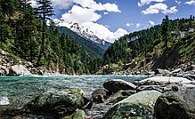
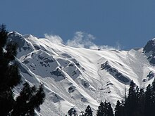
Khyber Pakhtunkhwa sits primarily on the Iranian plateau and comprises the junction where the slopes of the Hindu Kush mountains on the Eurasian plate give way to the Indus-watered hills approaching South Asia. This situation has led to seismic activity in the past.[121] The famous Khyber Pass links the province to Afghanistan, while the Kohalla Bridge in Circle Bakote Abbottabad is a major crossing point over the Jhelum River in the east.

Geographically the province could be divided into two zones: the northern zone extending from the ranges of the Hindu Kush to the borders of the Peshawar basin and the southern zone extending from Peshawar to the Derajat basin.
The northern zone is cold and snowy in winters with heavy rainfall and pleasant summers with the exception of the Peshawar basin, which is hot in summer and cold in winter. It has moderate rainfall.[citation needed]
The southern zone is arid with hot summers and relatively cold winters and scanty rainfall.[122] The Sheikh Badin Hills, a spur of clay and sandstone hills that stretch east from the Sulaiman Mountains to the Indus River, separates Dera Ismail Khan District from the Marwat plains of the Lakki Marwat. The highest peak in the range is the limestone Sheikh Badin Mountain, which is protected by the Sheikh Badin National Park. Near the Indus River, the terminus of the Sheikh Badin Hills is a spur of limestone hills known as the Kafir Kot hills, where the ancient Hindu complex of Kafir Kot is located.[123]
The major rivers that criss-cross the province are Kabul, Swat, Chitral, Kunar, Siran, Panjkora, Bara, Kurram, Dor, Haroo, Gomal, and Zhob.
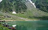
Its snow-capped peaks and lush green valleys of unusual beauty have enormous potential for tourism.[124]
Climate
[edit]The climate of Khyber Pakhtunkhwa varies immensely for a region of its size, encompassing most of the many climate types found in Pakistan. The province stretching southwards from the Baroghil Pass in the Hindu Kush covers almost six degrees of latitude; it is mainly a mountainous region. Dera Ismail Khan is one of the hottest places in South Asia while in the mountains to the north the weather is mild in the summer and intensely cold in the winter. The air is generally very dry; consequently, the daily and annual range of temperature is quite large.[125]
Rainfall also varies widely. Although large parts of Khyber Pakhtunkhwa are typically dry, the province also contains the wettest parts of Pakistan in its eastern fringe especially in monsoon season from mid-June to mid-September.
Upper and Lower Chitral Districts
[edit]Upper Chitral District and Lower Chitral District, due to their location, are completely sheltered from the monsoon that controls the weather in eastern Pakistan, owing to its relatively westerly location and the shielding effect of the Nanga Parbat massif. In many ways, they have more in common regarding climate with Central Asia than South Asia.[126] The winters are generally cold even in the valleys, and heavy snow during the winter blocks passes and isolates the region. In the valleys, however, summers can be hotter than on the windward side of the mountains due to lower cloud cover: Chitral can reach 40 °C (104 °F) frequently during this period.[127] However, the humidity is extremely low during these hot spells and, as a result, the summer climate is less torrid than in the rest of the Indian subcontinent.
Most precipitation falls as thunderstorms or snow during winter and spring, so that the climate at the lowest elevations is classed as Mediterranean (Csa), continental Mediterranean (Dsa) or semi-arid (BSk). Summers are extremely dry in the north of Chitral district and receive only a little rain in the south around Drosh.
At elevations above 5,000 metres (16,400 ft), as much as a third of the snow which feeds the large Karakoram and Hindukush glaciers comes from the monsoon since these elevations are too high to be shielded from its moisture.[126]
Central Khyber Pakhtunkhwa
[edit]| Dir | ||||||||||||||||||||||||||||||||||||||||||||||||||||||||||||
|---|---|---|---|---|---|---|---|---|---|---|---|---|---|---|---|---|---|---|---|---|---|---|---|---|---|---|---|---|---|---|---|---|---|---|---|---|---|---|---|---|---|---|---|---|---|---|---|---|---|---|---|---|---|---|---|---|---|---|---|---|
| Climate chart (explanation) | ||||||||||||||||||||||||||||||||||||||||||||||||||||||||||||
| ||||||||||||||||||||||||||||||||||||||||||||||||||||||||||||
| ||||||||||||||||||||||||||||||||||||||||||||||||||||||||||||
On the southern flanks of Nanga Parbat and in Upper and Lower Dir Districts, rainfall is much heavier than further north because moist winds from the Arabian Sea are able to penetrate the region. When they collide with the mountain slopes, winter depressions provide heavy precipitation. The monsoon, although short, is generally powerful. As a result, the southern slopes of Khyber Pakhtunkhwa are the wettest part of Pakistan. Annual rainfall ranges from around 500 millimetres (20 in) in the most sheltered areas to as much as 1,750 millimetres (69 in) in parts of Abbottabad and Mansehra Districts.
This region's climate is classed at lower elevations as humid subtropical (Cfa in the west; Cwa in the east); whilst at higher elevations with a southerly aspect, it becomes classed as humid continental (Dfb). However, accurate data for altitudes above 2,000 metres (6,560 ft) are practically nonexistent here, in Chitral, or in the south of the province.
| Dera Ismail Khan | ||||||||||||||||||||||||||||||||||||||||||||||||||||||||||||
|---|---|---|---|---|---|---|---|---|---|---|---|---|---|---|---|---|---|---|---|---|---|---|---|---|---|---|---|---|---|---|---|---|---|---|---|---|---|---|---|---|---|---|---|---|---|---|---|---|---|---|---|---|---|---|---|---|---|---|---|---|
| Climate chart (explanation) | ||||||||||||||||||||||||||||||||||||||||||||||||||||||||||||
| ||||||||||||||||||||||||||||||||||||||||||||||||||||||||||||
| ||||||||||||||||||||||||||||||||||||||||||||||||||||||||||||
The seasonality of rainfall in central Khyber Pakhtunkhwa shows very marked gradients from east to west. At Dir, March remains the wettest month due to frequent frontal cloud bands, whereas in Hazara more than half the rainfall comes from the monsoon.[130] This creates a unique situation characterized by a bimodal rainfall regime, which extends into the southern part of the province described below.[130]
Since cold air from the Siberian High loses its chilling capacity upon crossing the vast Karakoram and Himalaya ranges, winters in central Khyber Pakhtunkhwa are somewhat milder than in Chitral. Snow remains very frequent at high altitudes but rarely lasts long on the ground in the major towns and agricultural valleys. Outside of winter, temperatures in central Khyber Pakhtunkhwa are not so hot as in Chitral. [citation needed]
Significantly higher humidity when the monsoon is active means that heat discomfort can be greater. However, even during the most humid periods the high altitudes typically allow for some relief from the heat overnight.[131]
Southern Khyber Pakhtunkhwa
[edit]As one moves further away from the foothills of the Himalaya and Karakoram ranges, the climate changes from the humid subtropical climate of the foothills to the typically arid climate of Sindh, Balochistan and southern Punjab. As in central Khyber Pakhtunkhwa, the seasonality of precipitation shows a very sharp gradient from west to east, but the whole region very rarely receives significant monsoon rainfall. Even at high elevations, annual rainfall is less than 400 millimetres (16 in) and in some places as little as 200 millimetres (8 in).
Temperatures in southern Khyber Pakhtunkhwa are extremely hot: Dera Ismail Khan in the southernmost district of the province is known as one of the hottest places in the world with temperatures known to have reached 50 °C (122 °F).[132] In the cooler months, nights can be cold and frosts remain frequent; snow is very rare, and daytime temperatures remain comfortably warm with abundant sunshine.
National parks
[edit]There are about 29 National Parks in Pakistan and 7 in Khyber Pakhtunkhwa.


Demographics
[edit]| Year | Pop. | ±% |
|---|---|---|
| 1868 | 1,713,596 | — |
| 1881 | 1,955,515 | +14.1% |
| 1891 | 2,281,708 | +16.7% |
| 1901 | 2,125,480 | −6.8% |
| 1911 | 3,819,027 | +79.7% |
| 1921 | 5,076,476 | +32.9% |
| 1931 | 4,684,364 | −7.7% |
| 1941 | 5,415,666 | +15.6% |
| 1951 | 5,888,550 | +8.7% |
| 1961 | 7,578,186 | +28.7% |
| 1972 | 10,879,781 | +43.6% |
| 1981 | 13,259,875 | +21.9% |
| 1998 | 20,919,976 | +57.8% |
| 2017 | 35,501,964 | +69.7% |
| 2023 | 40,856,097 | +15.1% |
| Source: [133][134][135][136][137][138][139][140] | ||
The current province of Khyber Pakhtunkhwa had a population of 40.9 million at the time of the 2023 Census of Pakistan. Over 85% of the population lived in rural areas.[141]
Ethnicity
[edit]The largest ethnic group are the Pashtuns, who historically have been living in the areas for centuries.[142] It has been estimated that nearly a third of the province's population is non-Pashtun, mainly made up of Gujjar and Awan.[143]
Around 1.5 million Afghan refugees also remain in the province,[144] the majority of whom are Pashtuns followed by Tajiks, Hazaras, Gujjar, and other smaller groups. Despite having lived in the province for over two decades, they are registered as citizens of Afghanistan.[145]
The Pashtuns of Khyber Pakhtunkhwa observe tribal code of conduct called Pashtunwali which has four high value components called nang (honour), badal (revenge), melmastiya (hospitality) and nanawata (rights to refuge).[5]
Language
[edit]Urdu, being the national and official language, serves as a lingua franca for inter-ethnic communications, and sometimes Pashto and Urdu are the second and third languages among communities that speak other ethnic languages.[5]
According to the 2023 census, the most widely spoken language is Pashto, native to 81% of the population and spoken throughout the province.[146] Other languages with significant numbers of speakers include Hindko (9.39%), Saraiki (3.17%) and Kohistani languages (2.45%).[146] Hindko is primarily spoken in the Hazara division in the northeast, and Saraiki-speakers are found in Dera Ismail Khan district in the far south of the province.[6] Kohistani languages is an umbrella term encompassing several languages spoken in the north of the province, including Indus Kohistani, Bateri, Chilisso, Gawri, Gawro, Torwali, and Mankiyali.[147][148] Other combined 3.35% of the languages, overwhelmingly constituting Khowar and Kalasha are spoken in the mountainous northwest Chitral.[6]
In 2011 the provincial government approved in principle the introduction of Pashto, Saraiki, Hindko, Khowar and Kohistani as compulsory subjects for schools in the areas where they are spoken.[149]
Religion
[edit]The overwhelming majority of the residents of the Khyber Pakhtunkhwa follows and professes the Sunni Islam while there’s a significant amount of shia Muslims in areas such as Kurram, Kohat, Hangu, Orakzai, Dera Ismail khan, Mardan, and many other districts throughout central-southern kpk. Apart from Twelver Shias there are Isma'ilis in the Chitral district.[150] The tribe of Kalasha in southern Chitral still retain an ancient form of Polytheism mixed with Animism, a faith once dominant in the mountainous upper northeast of the district.[150] There are very small numbers of residents who are the adherents of Roman Catholicism denomination of Christianity, Hinduism and Sikhism, mainly living in Peshawar and other urban centres.[151][152]
| Religious group |
1881[140]: 17–18 | 1891[139]: 14–15 | 1901[138]: 34–36 | 1911[137]: 307–308 | 1921[136]: 345–346 | 1931[135]: 373–375 | ||||||||
|---|---|---|---|---|---|---|---|---|---|---|---|---|---|---|
| Pop. | % | Pop. | % | Pop. | % | Pop. | % | Pop. | % | Pop. | % | |||
| Islam |
1,787,341 | 91.4% | 2,088,015 | 91.51% | 1,890,479 | 92.19% | 2,039,994 | 92.86% | 2,062,786 | 91.62% | 2,227,303 | 91.84% | ||
| Hinduism |
154,081 | 7.88% | 166,984 | 7.32% | 129,306 | 6.31% | 119,942 | 5.46% | 149,881 | 6.66% | 142,977 | 5.9% | ||
| Sikhism |
9,205 | 0.47% | 21,110 | 0.93% | 25,733 | 1.25% | 30,345 | 1.38% | 28,040 | 1.25% | 42,510 | 1.75% | ||
| Christianity |
4,725 | 0.24% | 5,437 | 0.24% | 5,119 | 0.25% | 6,585 | 0.3% | 10,610 | 0.47% | 12,213 | 0.5% | ||
| Jainism |
106 | 0.01% | 108 | 0.005% | 37 | 0.002% | 4 | 0.0002% | 3 | 0.0001% | 0 | 0% | ||
| Zoroastrianism |
52 | 0.003% | 48 | 0.002% | 46 | 0.002% | 49 | 0.002% | 20 | 0.001% | 60 | 0.002% | ||
| Buddhism |
0 | 0% | 0 | 0% | 0 | 0% | 0 | 0% | 0 | 0% | 2 | 0.0001% | ||
| Judaism |
— | — | 4 | 0.0002% | 4 | 0.0002% | 14 | 0.001% | 0 | 0% | 11 | 0.0005% | ||
| Others | 5 | 0.0003% | 2 | 0.0001% | 0 | 0% | 0 | 0% | 0 | 0% | 0 | 0% | ||
| Total Responses[b] | 1,955,515 | 100% | 2,281,708 | 100% | 2,050,724 | 96.48% | 2,196,933 | 57.53% | 2,251,340 | 44.35% | 2,425,076 | 51.77% | ||
| Total Population[b] | 1,955,515 | 100% | 2,281,708 | 100% | 2,125,480 | 100% | 3,819,027 | 100% | 5,076,476 | 100% | 4,684,364 | 100% | ||
| Note: Pre-partition populations for religious data is for North-West Frontier Province only and excludes the Federally Administered Tribal Areas (both administrative divisions later merged to form Khyber Pakhtunkhwa in 2018), as religious data was not collected in the latter region at the time. | ||||||||||||||
| Religious group |
1941[134]: 22 | 1951[153]: 12–21 | 1998[154] | 2017[155] | 2023[156][157] | |||||||||
|---|---|---|---|---|---|---|---|---|---|---|---|---|---|---|
| Pop. | % | Pop. | % | Pop. | % | Pop. | % | Pop. | % | |||||
| Islam |
2,788,797 | 91.8% | 5,858,080 | 99.89% | 20,808,480 | 99.47% | 35,428,857 | 99.79% | 40,486,153 | 99.62% | ||||
| Hinduism |
180,321 | 5.94% | 2,432 | 0.04% | 7,011 | 0.03% | 6,373 | 0.02% | 6,102 | 0.02% | ||||
| Sikhism |
57,939 | 1.91% | — | — | — | — | — | — | 4,050 | 0.01% | ||||
| Christianity |
10,889 | 0.36% | 3,823 | 0.07% | 38,974 | 0.19% | 50,018 | 0.14% | 134,884 | 0.33% | ||||
| Judaism |
71 | 0.002% | — | — | — | — | — | — | — | — | ||||
| Buddhism |
25 | 0.001% | — | — | — | — | — | — | — | — | ||||
| Zoroastrianism |
24 | 0.001% | — | — | — | — | — | — | 36 | 0.0001% | ||||
| Jainism |
1 | 0% | — | — | — | — | — | — | — | — | ||||
| Ahmadiyya Muslims |
— | — | — | — | 48,703 | 0.23% | 7,204 | 0.02% | 951 | 0.002% | ||||
| Others | 0 | 0% | 215 | 0.004% | 16,808 | 0.08% | 9,512 | 0.03% | 8,944 | 0.02% | ||||
| Total Responses[b] | 3,038,067 | 56.1% | 5,864,550 | 100% | 20,919,976 | 100% | 35,501,964 | 100% | 40,641,120 | 99.47% | ||||
| Total Population[b] | 5,415,666 | 100% | 5,864,550 | 100% | 20,919,976 | 100% | 35,501,964 | 100% | 40,856,097 | 100% | ||||
| Note1: Pre-partition populations for religious data is for North-West Frontier Province only and excludes the Federally Administered Tribal Areas (both administrative divisions later merged to form Khyber Pakhtunkhwa in 2018), as religious data was not collected in the latter region at the time. Note2: 1951, 1998, and 2017 populations for religious data combine the North-West Frontier Province and Federally Administered Tribal Areas, both administrative divisions which later merged to form Khyber Pakhtunkhwa in 2018. | ||||||||||||||
Villages
[edit]Government and politics
[edit]
Political leanings and the legislative branch
[edit]The Provincial Assembly is a unicameral legislature, which consists of 145 members elected to serve for a constitutionally bounded term of five years. Historically, the province perceived to be a stronghold of the Awami National Party (ANP); a pro-Russian, by procommunist, left-wing and nationalist party.[158][159] Since the 1970s, the Pakistan Peoples Party (PPP) also enjoyed considerable support in the province due to its socialist agenda.[158] Khyber Pakhtunkhwa was thought to be another leftist region of the country after Sindh.[159]
After the nationwide general elections held in 2002, a plurality voting swing in the province elected one of Pakistan's only religiously based provincial governments led by the ultra-conservative Muttahida Majlis-e-Amal (MMA) during the administration of President Pervez Musharraf. The American involvement in neighbouring Afghanistan contributed towards the electoral victory of the Islamic coalition led by Jamaat-e-Islami Pakistan (JeI) whose social policies made the province a ground-swell of anti-Americanism.[160] The electoral victory of MMA was also in context of guided democracy in the Musharraff administration that barred the mainstream political parties, the leftist Pakistan Peoples Party and the centre-right Pakistan Muslim League (N) (PML(N)), whose chairmen and presidents having been barred from participation in the elections.[161]
Policy enforcement of a range of social restrictions, though the implementation of strict Shariah was introduced by the Muttahida Majlis-e-Amal government the law was never fully enacted due to objections of the Governor of Khyber Pakhtunkhwa backed by the Musharraff administration.[160] Restrictions on public musical performances were introduced, as well as a ban prohibiting music to be played in public places as part of the "Prohibition of Dancing and Music Bill, 2005" – which led to the creation of a thriving underground music scene in Peshawar.[162] The Islamist government also attempted to enforce compulsory hijab on women,[163] and wished to enforce gender segregation in the province's educational institutions.[163] The coalition further tried to prohibit male doctors from performing ultrasounds on women,[163] and tried to close the province's cinemas.[163] In 2005, the coalition successfully passed the "Prohibition of Use of Women in Photograph Bill, 2005," leading to the removal of all public advertisements that featured women.[164]
At the height of Taliban insurgency in Pakistan, the religious coalition lost its grip in the general elections held in 2008, and the religious coalition was swept out of power by the leftist Awami National Party which also witnessed the resignation of President Musharraf in 2008.[160] The ANP government eventually led the initiatives to repeal the major Islamist's social programs, with the backing of the federal government led by PPP in Islamabad.[165] Public disapproval of ANP's leftist program integrated in civil administration with the sounded allegations of corruption as well as popular opposition against religious program promoted by the MMA swiftly shifted the province's leniency away from the left in 2012.[158] In 2013, the provincial politics shifted towards populism and nationalism when the PTI, led by Imran Khan, was able to form the minority government in coalition with the JeI; the province now serves as the stronghold of the PTI and is perceived as one of the more right wing areas of the country.[166] After the 2018 election, PTI increased their seat share and formed a majority government.
In non-Pashtun areas, such as Abbottabad, and Hazara Division, the PML(N), the centre-right party, enjoys considerable public support over economical and public policy issues and has a substantial vote bank.[166]
Executive branch
[edit]The executive branch of the Kyber Pakhtunkhwa is led by the Chief Minister elected by popular vote in the Provincial assembly[167] while the Governor, a ceremonial figure representing the federal government in Islamabad, is appointed from the necessary advice of the Prime Minister of Pakistan by the President of Pakistan.[168]
The provincial cabinet is then appointed by the Chief Minister who takes the Oath of office from the Governor.[169] In matters of civil administration, the Chief Secretary assists the Chief Minister on executing its right to ensure the writ of the government and the constitution.[150][170]
Judicial branch
[edit]The Peshawar High Court is the province's highest court of law whose judges are appointed by the approval of the Supreme Judicial Council in Islamabad, interpreting the laws and overturn those they find unconstitutional.
Administrative divisions and districts
[edit]Khyber Pakhtunkhwa is divided into seven Divisions – Bannu, Dera Ismail Khan, Hazara, Kohat, Malakand, Mardan, and Peshawar. Each division is split up into anywhere between two and nine districts, and there are 36 districts in the entire province. Below you can find a list showing each district ordered by alphabetical order. A full list showing different characteristics of each district, such as their population, area, and a map showing their location can be found at the main article.
- Abbottabad District
- Allai District
- Bajaur District
- Bannu District
- Battagram District
- Buner District
- Charsadda District
- Central Dir District
- Dera Ismail Khan District
- Hangu District
- Haripur District
- Karak District
- Khyber District
- Kohat District
- Kolai-Palas District
- Kurram District
- Lakki Marwat District
- Lower Chitral District
- Lower Dir District
- Lower Kohistan District
- Lower South Waziristan District
- Malakand District
- Mansehra District
- Mardan District
- Mohmand District
- North Waziristan District
- Nowshera District
- Orakzai District
- Peshawar District
- Shangla District
- Swabi District
- Swat District
- Tank District
- Tor Ghar District
- Upper South Waziristan District
- Upper Chitral District
- Upper Dir District
- Upper Kohistan District
Major cities
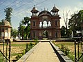
[edit]Peshawar is the capital and largest city of Khyber Pakhtunkhwa. The city is the most populous and comprises more than one-eighth of the province's population.
Largest cities or towns in Khyber Pakhtunkhwa |
|---|


Economy
[edit]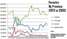
Хайбер-Пахтунхва имеет третью по величине экономику провинции в Пакистане. Доля Хайбер-Пахтунхвы в ВВП Пакистана исторически составляла 10,5%, хотя на долю провинции проживает 11,9% от общей численности населения Пакистана. Частью экономики Хайбер-Пахтунхвы является лесное хозяйство, где его доля исторически колебалась от минимума в 34,9% до максимума в 81%, что дает в среднем 61,56%. [ 171 ] В настоящее время на Хайбер-Пахтунхву приходится 10% ВВП Пакистана. [ 172 ] 20% добычи полезных ископаемых Пакистана [ 173 ] а с 1972 года ее экономика выросла в 3,6 раза. [ 174 ]
Сельское хозяйство остается важным, и основные товарные культуры включают пшеницу, кукурузу, табак (в Сваби), рис, сахарную свеклу, а также фрукты, выращиваемые в провинции.
Некоторые инвестиции в производство и высокие технологии в Пешаваре помогли улучшить перспективы трудоустройства для многих местных жителей, а торговля в провинции охватывает почти все товары. Базары провинции известны на весь Пакистан. Безработица сократилась за счет создания промышленных зон.
Мастерские по всей провинции поддерживают производство стрелкового оружия и вооружений. На долю провинции приходится не менее 78% производства мрамора в Пакистане. [ 175 ]
Инфраструктура
[ редактировать ]Проект гидроэлектростанции Шармаи — это предлагаемый проект по производству электроэнергии, расположенный в районе Верхний Дир провинции Хайбер-Пахтунхва на реке Панджкора , с установленной мощностью 150 МВт. [ 176 ]
Социальные проблемы
[ редактировать ]стремилась Национальная партия Авами переименовать провинцию в «Пахтунхва», что на языке пушту переводится как «Земля пуштунов» . [ 177 ] Против этого выступили некоторые непуштуны в провинции и политические партии, такие как Пакистанская мусульманская лига-N (PML-N) и Муттахида Маджлис-и-Амаль (MMA), поскольку PML-N получила поддержку в провинции. преимущественно из непуштунских хазарейских регионов.
В 2010 году объявление о новом названии провинции вызвало волну протестов в Хазарейском регионе. [ 178 ] 15 апреля 2010 года сенат Пакистана официально назвал провинцию Хайбер-Пахтунхва: 80 сенаторов высказались за и 12 выступили против. [ 179 ] ММА, которая до выборов 2008 года имела большинство в правительстве Хайбер-Пахтунхвы, предложила «Афганию» в качестве компромиссного названия. [ 180 ]
После всеобщих выборов 2008 года Авами Национальная партия сформировала коалиционное провинциальное правительство с Пакистанской народной партией . [ 181 ] Оплоты Авамийской национальной партии находятся в пуштунских районах Пакистана, особенно в долине Пешавара, а в Карачи в Синде проживает одно из крупнейших пуштунских популяций в мире — по некоторым оценкам, около 7 миллионов человек. [ 182 ] На выборах 2008 года ННП получила два места в законодательном собрании провинции Синд в Карачи. Национальная партия Авами сыграла важную роль в борьбе с Талибаном. На всеобщих выборах 2013 года Пакистан «Техрик-и-Инсаф» получил большинство в провинциальном собрании и теперь сформировал свое правительство в коалиции с «Джамаат-и-Ислами Пакистан» . [ 183 ]
Неправительственные организации
[ редактировать ]Ниже приводится список некоторых крупных НПО, работающих в Хайбер-Пахтунхве: [ 184 ] [ 185 ]
- Фонд Аль-Хидмат
- Фонд Аурат
- Мемориальная онкологическая больница и исследовательский центр Шаукат Ханум
- Программа поддержки сельских районов Сархад
- Комиссия по правам человека Пакистана
- Фонд пограничного образования
Народная музыка и культура
[ редактировать ]Пуштуанская народная музыка популярна в Хайбер-Пахтунхве и имеет богатые традиции, насчитывающие сотни лет. Основными инструментами являются рубаб , манги и фисгармония . Ховарская народная музыка популярна в Читрале и северном Свате. Мелодии ховарской музыки сильно отличаются от пуштуской, а основным инструментом является ситар Читрали. В Читрале популярна музыкальная группа, состоящая из кларнетов (Сурнаи) и барабанов. В него играют на матчах по поло и танцах. Такая же музыкальная группа звучит в соседних северных регионах . [ 186 ]
Образование
[ редактировать ]


| Год | Уровень грамотности |
|---|---|
| 1972 | 15.5% |
| 1981 | 16.7% |
| 1998 | 35.41% |
| 2017 | 51.66% |
| 2020 | 55.1% |
Источники: [ 187 ] [ 188 ] [ 189 ] [ 190 ]
В Хайбер-Пахтунхве традиционно очень низкий уровень грамотности, хотя в последнее время ситуация меняется. По данным переписи 2017 года уровень грамотности в Хайбер-Пахтунхве (включая ФУТП) составляет 51,66%. В сельской местности уровень грамотности составляет 48,44% населения, а в городах - 66,86%. В Хайбер-Пахтунхве наблюдается огромный разрыв в уровне грамотности между полами: среди мужчин он составляет 66,67%, тогда как уровень грамотности среди женщин составляет 34,58%, что составляет чуть более половины уровня грамотности среди мужчин. Этот разрыв особенно заметен в сельских районах, где преобладают пушту, где традиционные гендерные нормы обычно ограничивают образование женщин. По состоянию на 2021 год Хайбер-Пахтунхва (ХП) имеет самый высокий уровень роста грамотности во всей стране ( Пакистан ). [ 189 ] [ 190 ]
Это оценка рынка образования Хайбер-Пахтунхвы. [ 191 ] правительством в 1998 г. [ 192 ]
| Квалификация | Городской | Деревенский | Общий | Коэффициент охвата (%) |
|---|---|---|---|---|
| Ниже начальной | 413,782 | 3,252,278 | 3,666,060 | 100.00 |
| Начальный | 741,035 | 4,646,111 | 5,387,146 | 79.33 |
| Середина | 613,188 | 2,911,563 | 3,524,751 | 48.97 |
| Зачисление | 647,919 | 2,573,798 | 3,221,717 | 29.11 |
| Средний | 272,761 | 728,628 | 1,001,389 | 10.95 |
| Бакалавр, Бакалавр ... степени | 20,359 | 42,773 | 63,132 | 5.31 |
| MA, MSc ... степени | 18,237 | 35,989 | 53,226 | 4.95 |
| Диплом, Сертификат... | 82,037 | 165,195 | 247,232 | 1.92 |
| Другая квалификация | 19,766 | 75,226 | 94,992 | 0.53 |
| — | 2,994,084 | 14,749,561 | 17,743,645 | — |
Государственные медицинские колледжи
[ редактировать ]В провинции Хайбер-Пахтунхва (КПК) имеется 9 государственных медицинских колледжей:
- Хайберский медицинский университет , Пешавар
- Медицинский колледж Банну , Банну
- Хайберский женский медицинский колледж , Пешавар
- Медицинский колледж Аюб , Абботтабад
- Медицинский колледж Бача Хана , Мардан
- Медицинский колледж Гаджу Хана Сваби
- Гомальский медицинский колледж , ДИХАН
- Медицинский колледж Новшера , Новшера
- Медицинский колледж Саиду, Сват
Инженерные университеты
[ редактировать ]- CECOS , Пешавар Университет информационных технологий и новых наук
- Национальный университет наук и технологий , Исламабад, колледж авиационной техники , кампус Рисалпур
- Институт информационных технологий COMSATS , Исламабад (Кампус Абботтабад)
- Городской университет науки и информационных технологий, Пешавар
- Гандхарский институт науки и технологий, Инженерный колледж PGS ( Инженерный и технологический университет, Пешавар )
- Институт инженерных наук и технологий Гулама Исхака Хана , Топи-Сваби
- Университет Икра в Пешаваре (ранее Университет Икра, Карачи (кампус в Пешаваре)
- Национальный университет наук и технологий , Исламабад, Военный инженерный колледж , кампус Рисалпур
- Национальный университет компьютерных и новых наук , Исламабад (кампус в Пешаваре)
- Университет инженерии и технологий, Пешавар (главный кампус)
- Инженерно-технологический университет, Пешавар (кампус Мардан)
- Университет инженерии и технологий, Пешавар (кампус Банну)
- Университет инженерии и технологий, Пешавар (кампус Абботтабад)
- Университет инженерии и технологий, Пешавар (кампус Кохат)
- Университет науки и информационных технологий Сархад, Пешавар
- Абасынский университет, Пешавар
- Университет науки и технологий, Банну
- IMSciences , Пешавар
- Гомальский университет, Дера Исмаил Хан
Основные учебные заведения
[ редактировать ]- Кадетский колледж Размак , округ Северный Вазиристан.
- Государственная школа Абботтабада , Абботтабад
- Колледж Акрама Хана Дуррани , Банну
- Армейский колледж Берн-Холл , Абботтабад
- Университет науки и технологий Банну , Банну
- Кадетский колледж Кохат , Кохат
- Колледж Эдвардс , Пешавар
- Университет Абдул Вали Хана, Мардан , Мардан
- Гомальский университет , Дера Исмаил Хан
- Университет Исламия Колледж , Пешавар
- Сельскохозяйственный университет , Пешавар
- Университет Малаканда , Чакдара
- Университет Пешавара , Пешавар
- Университет Хушал Хана Хатака , Карак
- IMSciences , Пешавар
- Колледж с высшим образованием , Пешавар
- Хайберский медицинский университет , Пешавар
- Хайберский женский медицинский колледж , Пешавар
- Хайберский медицинский колледж , Пешавар
Спорт
[ редактировать ]Крикет - основной вид спорта в Хайбер-Пахтунхве. Здесь выросли спортсмены мирового уровня, такие как Шахид Африди , Юнис Хан , Хушдил Шах , Фаххар Заман , Насим Шах и Умар Гюль . Помимо производства игроков в крикет, Хайбер-Пахтунхва имеет честь быть местом рождения многих игроков в сквош мирового класса , в том числе таких великих игроков, как Хашим Хан, Камар Заман, Джахангир Хан и Джаншер Хан . [ нужна ссылка ]
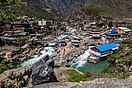
Туризм
[ редактировать ]

См. также
[ редактировать ]- Северный Пакистан
- Список городов Хайбер-Пахтунхвы по населению
- Список объектов культурного наследия Хайбер-Пахтунхвы
- Список больниц в Хайбер-Пахтунхве
- Список населенных пунктов Хайбер-Пахтунхвы
- Одежда Хайбер-Пахтунхвы
- Провинциальные дороги Хайбер-Пахтунхвы
- Туризм в Хайбер-Пахтунхве
- Северо-Западная пограничная провинция
- Территории племен федерального управления
Примечания
[ редактировать ]- ^ Перейти обратно: а б Вклад КПК в национальную экономику в 2022 году составил 10,39%, или $152 млрд (ППС) и $38 млрд (номинал). [ 2 ] [ 3 ]
- ^ Перейти обратно: а б с д и Популяции до разделения для религиозных данных относятся только к Северо-Западной пограничной провинции и исключают территории племен, находящиеся под федеральным управлением (обе административные единицы позже объединились в Хайбер-Пахтунхва в 2018 году), поскольку религиозные данные в последнем регионе в то время не собирались.
По религиозным данным население за 1951, 1998 и 2017 годы объединяет Северо-Западную пограничную провинцию и федерально управляемые территории племен — административные единицы, которые позже объединились в Хайбер-Пахтунхва в 2018 году. - ^ 1951, 1998, 2017, 2023: Включая индуистские (джати) и зарегистрированные касты.
Ссылки
[ редактировать ]- ^ «Объявление результатов 7-й переписи населения и жилищного фонда-2023 (провинция Хайбер-Пахтунхва)» (PDF) . Статистическое бюро Пакистана . 5 августа 2023 г. Архивировано (PDF) из оригинала 6 октября 2023 г. . Проверено 25 ноября 2023 г.
- ^ «ВВП районов Хайбер-Пухтунхвы» (PDF) . kpbos.gov.pk . Архивировано (PDF) из оригинала 21 ноября 2023 года . Проверено 15 мая 2023 г.
- ^ «Отчет по избранным странам и субъектам» . Архивировано из оригинала 3 июня 2023 года . Проверено 15 мая 2023 г.
- ^ «Субнациональный ИЧР – Лаборатория глобальных данных» . Globaldatalab.org . Архивировано из оригинала 4 апреля 2023 года . Проверено 2 марта 2022 г.
- ^ Перейти обратно: а б с Клаус, Питер Дж.; Даймонд, Сара; Энн Миллс, Маргарет (2003). Южноазиатский фольклор: Энциклопедия: Афганистан, Бангладеш, Индия, Непал, Пакистан, Шри-Ланка . Тейлор и Фрэнсис. п. 447. ИСБН 978-0415939195 .
- ^ Перейти обратно: а б с «Этнолингвистические провинции» . «Экспресс Трибьюн» . 25 июня 2011 г. Архивировано из оригинала 23 сентября 2021 г.
Хайбер-Пахтунхва может получить пуштоязычные районы Белуджистана, но потеряет хиндкоязычные части провинции Хазара, районы, говорящие на сирайки, - провинции Сираики и Ховар. и другие меньшие языковые области в еще одну провинцию.
- ^ 14 апреля 2010 г., Калсум Лакхани (14 апреля 2010 г.). «Провинция под любым другим названием» . Внешняя политика . Архивировано из оригинала 23 апреля 2023 года.
{{cite web}}: CS1 maint: числовые имена: список авторов ( ссылка ) - ^ Рафи У. Самад, Величие Гандхары: древняя буддийская цивилизация долин Свата, Пешавара, Кабула и Инда . Издательство Алгора, 2011. ISBN 0875868592
- ^ «НС одобряет слияние Фата, Пата с КП» . www.thenews.com.pk . Архивировано из оригинала 15 ноября 2021 года . Проверено 9 мая 2023 г.
- ^ Хаят, Ариф (27 мая 2018 г.). «Ассамблея КП одобряет знаковый законопроект о слиянии Фата с провинцией» . Dawn.com . Архивировано из оригинала 27 мая 2018 года . Проверено 28 мая 2018 г.
- ^ Перейти обратно: а б «Президент подписывает закон о слиянии Фата-КП» . Нация . 1 июня 2018 года. Архивировано из оригинала 8 марта 2021 года . Проверено 15 июня 2018 г.
- ^ «Президент подписывает законопроект о слиянии ФУТП с КП» . Гео Новости . Архивировано из оригинала 15 июня 2018 года . Проверено 15 июня 2018 г.
- ^ Государственный департамент США (2011). Справочная информация: Южная Азия, май 2011 г. InfoStrategist.com. ISBN 978-1592431298 .
- ^ Марват, Фазал-ур-Рахим Хан (1997). Эволюция и рост коммунизма в Афганистане, 1917–79: оценка . Королевская книжная компания, с. ХХХV.
- ^ Барнс, Роберт Харрисон; Грей, Эндрю; Кингсбери, Бенедикт (1995). Коренные народы Азии . Ассоциация азиатских исследований. п. 171. ИСБН 0924304146 .
- ^ Перейти обратно: а б «Это КП, а не КПК» . www.thenews.com.pk . Проверено 23 апреля 2023 г.
Первоначально для провинции предлагалось несколько названий. Они варьировались от древних названий Гандхара и Афганистан до спорных Пахтунистан и Паштунистан и абсурдного Патанистан, а также от Абасина, обозначающего протекающую через него реку Инд, до бессмысленного Сархада.
- ^ Перейти обратно: а б с д и «Спор по поводу переименования СЗПП» . Индус . 22 марта 2010 г. ISSN 0971-751X . Проверено 23 апреля 2023 г.
Помимо Пухтунхвы, на рассмотрении находятся еще пять имен. ННП предложила Пухтунистан и Афганистан. И PML (N) Гандхара, Хайбер и Аббасин (пушту для реки Инд). Старший лидер ННП Захид Хан надеялся на компромисс по этому вопросу и предположил, что руководство двух партий может согласиться на название, написанное через дефис, которое понравится всем.
- ^ Хамид, Шахид (22 марта 2014 г.). «Они разделились: Ассамблея ХП принимает две резолюции по провинции Хазара» . «Экспресс Трибьюн» . Проверено 20 июля 2024 г.
- ^ «Переименование СЗПП: ПМЛ-Н предполагает «Хазарский Пахтунхва» » . Рассвет . 13 апреля 2010 года . Проверено 23 апреля 2023 г.
- ^ Моррисон, Кэмерон (1909). Новая география Индийской империи и Цейлона . Т.Нельсон и сыновья. п. 176 .
- ^ Айерс, Алисса (23 июля 2009 г.). Говоря как государство: язык и национализм в Пакистане . Издательство Кембриджского университета . п. 61. ИСБН 978-0521519311 .
- ^ Перейти обратно: а б с д «СЗЛП в поисках имени» . pakhtunkhwa.com . Архивировано из оригинала 31 января 2016 года . Проверено 24 января 2016 г.
- ^ Моррисон, Кэмерон (1909). Новая география Индийской империи и Цейлона . Т.Нельсон и сыновья. п. 176 .
- ^ Чоудхари Рахмат Али, 1947, Пакистан: Родина пакистанской нации , Кембридж, ОСЛК 12241695
- ^ Вопрос идентичности, доктор Шер Заман Тайзай [узурпировал]
- ^ Перейти обратно: а б с д и Абдус Саттар Газали. «Пахтунхва: переименование СЗПП». Исламский Пакистан: иллюзии и реальность.
- ^ "АНП просит оппонентов не поднимать проблему Пахтунхвы". 5 ноября 2008 г. Проверено 15 апреля 2010 г.
- ^ «Пакистан переименовывает Северо-Западную пограничную провинцию, чтобы положить конец «колониальному анахронизму» — Телеграф» . 29 мая 2008 г. Архивировано из оригинала 29 мая 2008 г. . Проверено 23 апреля 2023 г.
- ^ Васим, Амир (25 мая 2008 г.). «ГЧП стремится укротить президентство и расширить возможности парламента» . РАССВЕТ.КОМ . Проверено 23 апреля 2023 г.
- ^ ПМЛ-Н может выступать против переименования СЗПП в Пахтунхва - Новости
- ^ Риаз Хан. «АНП ликует, когда Пахтунхва отзывается эхом в ГА ООН». 27 сентября 2008 г. Проверено 29 сентября 2008 г.
- ^ Айерс, Алисса (23 июля 2009 г.). Говоря как государство: язык и национализм в Пакистане . Издательство Кембриджского университета . п. 61. ИСБН 978-0521519311 .
- ^ «СЗПП официально переименован в Хайбер-Пахтунхва» . Dawn.com . 15 апреля 2010 года . Проверено 15 апреля 2010 г.
- ^ «Семеро убиты в результате беспорядков в Абботтабаде» . Dawn.com . 13 апреля 2010 года . Проверено 11 апреля 2010 г.
- ^ Шахин, Сикандер (14 апреля 2010 г.). «В Хазарской дивизии наблюдалась полная забастовка» . Нация . Проверено 11 апреля 2020 г.
- ^ «Инцидент со стрельбой в Абботтабаде: Техрик Суба Хазара просит Хатака отдать приказ о регистрации РПИ» . «Экспресс Трибьюн» . 17 сентября 2014 года . Проверено 13 апреля 2020 г. .
- ^ Перейти обратно: а б Карин Брюльяр. «Напряженность вокруг переименования провинции Пакистан омрачает правительственные реформы». Вашингтон Пост . 17 апреля 2010 г. Проверено 17 апреля 2010 г.
- ^ « Нет, ННП по-прежнему несогласна с переименованием СЗПП» . Нация . 22 марта 2010 г. Проверено 23 апреля 2023 г.
Он сказал, что PML-N также предложил название «Гандхара», но половина населения Гандхары проживает в Пенджабе, поэтому согласится ли Пенджаб включить эту часть в СЗПП, спросил он.
- ^ 14 апреля 2010 г., Калсум Лакхани. «Провинция под любым другим названием» . Внешняя политика . Проверено 23 апреля 2023 г.
Но Пакистанская мусульманская лига-Наваз (ПМЛ-Н), основная консервативная политическая партия с оплотом в провинции Пенджаб, решительно выступила против этого ярлыка (официально призывая к референдуму в сентябре прошлого года), утверждая, что этот титул маргинализирует другие этнические и языковые группы в провинции Пенджаб. провинции, включая говорящих на хиндко, сераики и ховарах. Тупик по поводу названия продолжался, и в качестве компромисса был предложен ряд альтернативных названий. В то время как некоторые из них отражали более нейтральные географические районы (Хайбер, Нилаб и Абасин) и исторические ссылки (Гандхара, старое название региона буддийской эпохи), другие заслуживающие внимания вторые места включали Афганистан, тайную букву «А» в слове «Пакистан», придуманную одним из первых сторонников пакистанского государства Чаудри Рехматом Али в 1933 году.
{{cite web}}: CS1 maint: числовые имена: список авторов ( ссылка ) - ^ Брайант, Эдвин Фрэнсис (2002). Поиски истоков ведической культуры: дебаты об индоарийской миграции . Издательство Оксфордского университета. п. 138. ИСБН 978-0-19-565361-8 .
- ^ Перейти обратно: а б Кульке, профессор истории Азии Герман; Кульке, Герман; Ротермунд, Дитмар (2004). История Индии . Психология Пресс. ISBN 978-0-415-32919-4 .
- ^ Перейти обратно: а б Варику, К. (2004). Бамиан: вызов всемирному наследию . Третий глаз. ISBN 978-81-86505-66-3 .
- ^ Перейти обратно: а б Хансен, Могенс Герман (2000). Сравнительное исследование тридцати культур городов-государств: исследование . Королевский Датское общество наук. ISBN 978-87-7876-177-4 .
- ^ Нилис, Ранние буддийские сети передачи и торговли, 2010 , стр. 232.
- ^ Эггермонт, Кампании Александра в Синде и Белуджистане, 1975 , стр. 175–177.
- ^ Бадиан, Эрнст (1987), «Александр в Пеуселаотисе», The Classical Quarterly , 37 (1): 117–128, doi : 10.1017/S0009838800031712 , JSTOR 639350 , S2CID 246878679
- ^ «Ригведа 1.126:7, английский перевод Ральфа Т.Х. Гриффита» .
- ^ Перейти обратно: а б Артур Энтони Макдонелл (1997). История санскритской литературы . Мотилал Банарсидасс. стр. 130–. ISBN 978-81-208-0095-3 .
- ^ «UW Press: Древние буддийские свитки из Гандхары» . Проверено в апреле 2018 г.
- ^ ЯЗЫК ГАНДХАРИ , Иранская энциклопедия.
- ^ «Они разделились: Ассамблея ХП принимает две резолюции по провинции Хазара» . «Экспресс Трибьюн» . 22 марта 2014 года . Проверено 23 апреля 2023 г.
- ^ Перейти обратно: а б Хан, Риаз; Туси, Нахаль; Писатели, Associated Press (31 марта 2010 г.). «Пакистан приближается к переименованию нестабильного региона» . Сан-Диего Юнион-Трибьюн . Проверено 23 апреля 2023 г.
- ^ Перейти обратно: а б Хан, Риаз; Тооси, Нахаль (1 апреля 2010 г.). «Пакистан приближается к переименованию нестабильного региона» . Вашингтон Пост . Проверено 1 апреля 2010 г. [ мертвая ссылка ]
- ^ ( Дорожная карта Принстона к Регентам , стр. 80)
- ^ Мохиуддин, Ясмин (2007). Пакистан: Справочник по глобальным исследованиям . АВС-КЛИО. п. 36. ISBN 9781851098019 .
- ^ Перейти обратно: а б с «Исторический обзор КП» . Хумшехри . Архивировано из оригинала 11 марта 2015 года . Проверено 22 апреля 2015 г.
- ^ «Ригведа: Ригведа Книга 1: ГИМН CXXVI. Бхаваявья» . www.sacred-texts.com . Архивировано из оригинала 16 марта 2023 года . Проверено 16 марта 2023 г.
- ^ Кульке, профессор истории Азии Герман; Кульке, Герман; Ротермунд, Дитмар (2004). История Индии . Психология Пресс. ISBN 978-0-415-32919-4 .
- ^ Варику, К. (2004). Бамиан: вызов всемирному наследию . Третий глаз. ISBN 978-81-86505-66-3 . Архивировано из оригинала 30 ноября 2023 года . Проверено 20 января 2023 г.
- ^ Хансен, Могенс Герман (2000). Сравнительное исследование тридцати культур городов-государств: исследование . Королевский Датское общество наук. ISBN 978-87-7876-177-4 . Архивировано из оригинала 30 ноября 2023 года . Проверено 20 января 2023 г.
- ^ * Шмидт, Карл Дж. (1995). Атлас и обзор истории Южной Азии , стр. 120: «Помимо того, что Таксила была религиозным центром для буддистов, а также индуистов, она была процветающим центром искусства, культуры и обучения».
- Шринивасан, Дорис Мет (2008). «Индуистские божества в искусстве Гандхары», в Гандхаре, «Буддийское наследие Пакистана: легенды, монастыри и рай» , стр. 130–143: «Гандхара не была отрезана от центра раннего индуизма в долине Ганга. Эти два региона общие культурные и политические связи и торговые отношения, и это способствовало принятию и обмену религиозными идеями [...] Именно в эпоху Кушана произошел расцвет религиозных образов [...] Гандхара часто представляла свое собственное своеобразное выражение. буддийские и индуистские образы, с которыми он изначально соприкоснулся».
- Блёртон, Т. Ричард (1993). Индуистское искусство. Архивировано 15 января 2023 года в Wayback Machine , издательство Гарвардского университета: «Самые ранние изображения Шивы, изображающие его в чисто человеческом облике, происходят из области древней Гандхары» (стр. 84) и «Монеты из Гандхары первого века». Британская Колумбия показывает Лакшми [...] четырехрукую, сидящую на лотосе». (стр. 176)
- ^ ( Имперский географический справочник , стр. 148)
- ^ Перейти обратно: а б с д ( «Императорский географический справочник» , стр. 149)
- ^ ( Фабер и Фабер , стр. 52–53)
- ^ «Будда в сопровождении Ваджрапани, имеющего характеристики греческого Геракла» Описание того же изображения на обложке в Стоунман, Ричард (8 июня 2021 г.). Греческий опыт Индии: от Александра до индо-греков . Издательство Принстонского университета. п. 4. ISBN 978-0-691-21747-5 . Также «Геракл нашел независимую жизнь в Индии в образе Ваджрапани, бородатого спутника Будды с дубинкой в руках». Стоунман, Ричард (8 июня 2021 г.). Греческий опыт Индии: от Александра до индо-греков . Издательство Принстонского университета. стр. 88–89. ISBN 978-0-691-21747-5 .
- ^ Величие Гандхары, Рафи-ус Самад, Algora Publishing, 2011, стр. 64-6.
- ^ Древняя Индия Рамеша Чандры Маджумдара с. 234
- ^ Перейти обратно: а б с ( «Имперский географический справочник» , стр. 150)
- ^ Рехман 1976 , с. 187 и пл. В. Б., «всадник изображен в головном уборе в виде тюрбана с небольшим шаром наверху».
- ^ Рахман, Абдул (2002). «Новый взгляд на хингалов, тюрков и индуистских сахов» (PDF) . Древний Пакистан . XV : 37–42. Архивировано (PDF) из оригинала 26 апреля 2021 года . Проверено 20 января 2023 г.
Таким образом, индуистские сахи не были ни бхатти, ни джанджуа, ни брахманами. Они были просто Уди/Оди. Теперь можно видеть, что термин «индуистские сахи» является неправильным употреблением и, поскольку он основан просто на религиозной дискриминации, его следует отбросить и забыть. Правильное название — династия Уди или Оди Шахи.
- ^ Мейстер, Майкл В. (2005). «Проблема расширения платформы на Северном Кафиркоте» (PDF) . Древний Пакистан . XVI : 41–48. Архивировано (PDF) из оригинала 1 февраля 2023 года . Проверено 20 января 2023 г.
Рехман (2002: 41) приводит веские доводы в пользу того, что индуистских шахи следует называть более точным именем «Уди-шахи».
- ^ Подмигните, Андре (1991). Аль-Хинд: Создание индо-исламского мира . БРИЛЛ. п. 125. ИСБН 978-90-04-09249-5 . Архивировано из оригинала 15 ноября 2023 года . Проверено 15 ноября 2023 г.
- ^ Шахи Афганистан и Пенджаб, 1973, стр. 1, 45–46, 48, 80, доктор Д.Б. Панди; Шаки в Индии и их влияние на индийскую жизнь и культуру, 1976, стр. 80, Вишва Митра Мохан – Индо-скифы; Страна, культура и политическая жизнь в ранней и средневековой Индии, 2004, стр. 34, Дауд Али.
- ^ Журнал Королевского азиатского общества, 1954, стр. 112 и далее; Шахи Афганистана и Пенджаба, 1973, стр. 46, д-р Д.Б. Панди; Шаки в Индии и их влияние на индийскую жизнь и культуру, 1976, стр. 80, Вишва Митра Мохан – Индо-скифы.
- ^ Индия, История, 2001, стр. 203, Джон Кей.
- ^ Сехрай, Фидаулла (1979). Хунд: Забытый город Гандхара , с. 2. Новая серия публикаций Пешаварского музея, Пешавар.
- ^ ( Винбрандт 2009 , стр. 52–54)
- ^ Перейти обратно: а б с д и ПМ Холт; Энн К.С. Лэмбтон; Бернард Льюис , ред. (1977), Кембриджская история ислама , издательство Кембриджского университета, стр. 3, ISBN 978-0-521-29137-8 ,
... Джайпала из Вайхинда увидел опасность в объединении королевства Газна и решил разрушить его. Поэтому он вторгся в Газну, но потерпел поражение...
- ^ Перейти обратно: а б с История Деккана Феришты от первых мусульманских завоеваний (и т. д.) . Шрусбери [англ.]: Напечатано для редактора Дж. и У. Эддоусами. 1794 г. - из Интернет-архива.
- ^ Винбрандт 2009 , стр. 52–55.
- ^ Сен, Сайлендра (2013). Учебник средневековой истории Индии . Книги Примуса. стр. 68–102. ISBN 978-9-38060-734-4 .
- ^ Перейти обратно: а б с д Босворт, Клиффорд Эдмунд (2007). Исторические города исламского мира . БРИЛЛ. ISBN 9789004153882 . Проверено 24 марта 2017 г.
- ^ Перейти обратно: а б с д и ж г час Ричардс, Джон Ф. (1995). Империя Великих Моголов . Издательство Кембриджского университета. ISBN 9780521566032 . Проверено 24 марта 2017 г.
- ^ Генри Майерс, Эллиот (2013) [1867]. История Индии, рассказанная ее собственными историками: мусульманский период . Издательство Кембриджского университета. ISBN 9781108055871 .
- ^ Ричардс, Джон Ф. (1996), «Имперская экспансия при Аурангзебе 1658–1869. Проверка границ империи: Северо-Запад», Империя Великих Моголов , Новая Кембриджская история Индии: Моголы и их современники, том. 5 (иллюстрировано, переиздание), Cambridge University Press, стр. 170–171, ISBN 978-0-521-56603-2 , заархивировано из оригинала 17 августа 2023 года , получено 28 марта 2017 года.
- ^ Шарма, СР (1999). Империя Великих Моголов в Индии: систематическое исследование, включая исходный материал, том 3 . Atlantic Publishers & Dist. ISBN 9788171568192 . Проверено 24 марта 2017 г.
- ^ Надием, Ихсан Х. (2007). Пешавар: наследие, история, памятники . Кровь и мед. ISBN 9789693519716 .
- ^ Аликузай, Хамид Вахед (октябрь 2013 г.). Краткая история Афганистана в 25 томах, том 14 . Траффорд. ISBN 9781490714417 . Архивировано из оригинала 22 марта 2023 года . Проверено 29 декабря 2014 г.
- ^ Сиддик, Абубакар (2014). Пуштунский вопрос: нерешенный ключ к будущему Пакистана и Афганистана . Херст. ISBN 9781849044998 .
- ^ Мередит Л. Рунион. История Афганистана. Архивировано 3 апреля 2023 г. в Wayback Machine, стр. 69 Greenwood Publishing Group, 2007 г. ISBN 0313337985
- ^ «Соперничество в Индии», CC Дэвис, Новая Кембриджская современная история , Vol. VII Старый режим 1713–63, изд. Дж. О. Линдси, (Издательство Кембриджского университета, 1988), 564.
- ^ Шофилд, Виктория, «Афганский фронтир: вражда и боевые действия в Центральной Азии», Лондон: Tauris Parke в мягкой обложке (2003), стр. 47
- ^ Ханифи, Шах (11 февраля 2011 г.). Соединение историй в Афганистане: рыночные отношения и формирование государства на колониальной границе . Издательство Стэнфордского университета. ISBN 978-0-8047-7777-3 . Архивировано из оригинала 10 марта 2023 года . Проверено 13 декабря 2012 г.
Тимур Шах перенес столицу Дуррани из Кандагара в период 1775 и 1776 годов. Затем Кабул и Пешавар делили время как двойные столицы Дуррани: первая летом, а вторая - зимой.
- ^ Перейти обратно: а б с д Дэни, Ахмад Хасан (2003). История цивилизаций Центральной Азии: Развитие в контрасте: с XVI до середины XIX века . ЮНЕСКО. ISBN 9789231038761 .
- ^ «Профиль страны: Афганистан» (PDF) . Страноведение Библиотеки Конгресса США . Август 2008 г. Архивировано из оригинала (PDF) 8 апреля 2014 г. . Проверено 30 января 2014 г.
- ^ Робсон, Кризис на границе, стр. 136–7.
- ^ «СЗПП до Хайбер-Пахтунхвы» . Блог.travel-cultural.com . 14 мая 2018 г. Архивировано из оригинала 15 мая 2018 г. . Проверено 14 мая 2018 г.
- ^ Эльст, Коенраад (2018). «70(б)». Почему я убил Махатму: раскрытие защиты Годзе . Нью-Дели: Рупа, 2018.
- ^ Панде, Апарна (2011). Объяснение внешней политики Пакистана: побег из Индии . Тейлор и Фрэнсис. п. 66. ИСБН 9781136818943 .
При обретении независимости в Северо-Западной границе существовало министерство под руководством Конгресса... Поддерживаемое Конгрессом правительство Северо-Западной границы во главе со светскими пуштунскими лидерами, братьями Хан, хотело присоединиться к Индии, а не к Пакистану. Если присоединение к Индии не было вариантом, то светские пуштунские лидеры поддержали идею Пуштунистана : этнического государства для пуштунов.
- ^ Али Шах, Сайид Вакар (1993). Марват, Фазал-ур-Рахим Хан (ред.). Афганистан и граница . Мичиганский университет : Emjay Books International. п. 256.
- ^ Х. Джонсон, Томас ; Зеллен, Барри (2014). Культура, конфликты и борьба с повстанцами . Издательство Стэнфордского университета . п. 154. ИСБН 9780804789219 . Архивировано из оригинала 16 ноября 2023 года . Проверено 27 января 2018 г.
- ^ Харрисон, Селиг С. «Пакистан: состояние Союза» (PDF) . Центр международной политики. стр. 13–14. Архивировано из оригинала (PDF) 23 сентября 2015 года . Проверено 24 января 2014 г.
- ^ Сингх, Випул (2008). Руководство Пирсона по истории Индии для предварительного экзамена UPSC по государственной службе . Пирсон. п. 65. ИСБН 9788131717530 .
- ^ Перейти обратно: а б с Юсеф Абул-Энейн; Василий Абул-Энейн (2013). Тайная война на Ближнем Востоке . Издательство Военно-морского института. п. 153. ИСБН 978-1612513096 .
- ^ Харун, Сана (2008). «Рост ислама деобанди в Северо-Западной пограничной провинции и его последствия в колониальной Индии и Пакистане 1914–1996». Журнал Королевского азиатского общества . 18 (1): 55. JSTOR 27755911 .
Позиция центрального JUH была проконгрессовской, и, соответственно, JUS поддерживал конгрессменов Худай Хидматгаров до выборов 1937 года. Однако светская позиция Гаффар Хана, лидера Худай Хидматгаров, пренебрегала ролью религии в правительстве и социальной жизни. руководство вбило клин между улемами JUS и Худай Хидматгарами, несмотря на обязательства о взаимной поддержке между JUH и руководством Конгресса. Пытаясь подчеркнуть обособленность и уязвимость мусульман в религиозно разнообразном публичном пространстве, директивы улемов СЗПП начали отклоняться от простых религиозных предписаний и приобретать коммуналистский тон. Улемы подчеркнули «угрозы», исходящие от индуистов мусульманам провинции. Обвинения в неподобающем поведении и приставаниях к мусульманкам были выдвинуты против «индуистских лавочников» в Новшере. В проповедях, произнесенных двумя связанными с JUS маулви в Новшере, индусы были объявлены «врагами» ислама и мусульман. В городе были распространены плакаты, предупреждающие мусульман не покупать и не употреблять пищу, приготовленную и проданную индусами на базарах. В 1936 году индуистская девушка была похищена мусульманином в Банну, а затем вышла за него замуж. Правительство требовало возвращения девушки. Но общественное мнение мусульман, поддержанное резолюцией Джамиятул Улама Банну, потребовало, чтобы она осталась, заявляя, что она пришла по своей свободной воле, приняла ислам, теперь состоит в законном браке и имеет остаться с мужем. Попытки правительства вернуть девочку привели к обвинениям правительства в антимусульманских настроениях и поощрении отступничества, что вызвало сильные антииндуистские настроения среди мусульманского большинства СЗПП.
- ^ Харун, Сана (2008). «Рост ислама деобанди в Северо-Западной пограничной провинции и его последствия в колониальной Индии и Пакистане 1914–1996». Журнал Королевского азиатского общества . 18 (1): 57–58. JSTOR 27755911 .
К 1947 году большинство улемов СЗПП поддержали идею Мусульманской лиги Пакистана. Из-за уже давних отношений между улемами JUS и Мусульманской лигой, а также из-за сильного коммунистического тона в СЗПП, отход от проконгрессовской и антипакистанской партийной линии центрального JUH к заинтересованности и участию в создании Пакистана, осуществленная СЗПП Деобандисом, не была драматичной.
- ^ Перейти обратно: а б Джеффри Дж. Робертс (2003). Истоки конфликта в Афганистане . Издательская группа Гринвуд. стр. 108–109. ISBN 9780275978785 . Проверено 18 апреля 2015 г.
- ^ Карл Э. Мейер (5 августа 2008 г.). Пыль Империи: гонка за мастерство в сердце Азии . Общественные дела. ISBN 9780786724819 . Проверено 25 июня 2019 г.
- ^ «Был ли Джинна демократическим? — II» . Ежедневные Таймс . 25 декабря 2011 г. Архивировано из оригинала 15 мая 2019 г. . Проверено 24 февраля 2019 г.
- ^ «Избирательная история СЗПП» (PDF) . Архивировано из оригинала (PDF) 10 августа 2013 года . Проверено 28 декабря 2013 г.
- ^ Абдул Гаффар Хан (1958) Пуштунский отряд Ау Ю. Пешавар.
- ^ «Все в Афганистане делается во имя религии: Хан Абдул Гаффар Хан» . Индия сегодня . Архивировано из оригинала 8 января 2019 года . Проверено 13 января 2014 г.
- ^ ( Кисслинг 2016 , стр. 8)
- ^ Перейти обратно: а б «Пакистано-афганские отношения в эпоху после 11 сентября, октябрь 2006 г., Фредерик Грар» (PDF) . Архивировано из оригинала (PDF) 3 октября 2006 года . Проверено 20 ноября 2013 г.
- ^ Барторп, Майкл (2002). Афганские войны и северо-западная граница, 1839–1947 гг . Касселл. стр. 85–90. ISBN 978-0-304-36294-3 . Архивировано из оригинала 3 апреля 2023 года . Проверено 20 января 2023 г.
- ^ Барторп, Майкл (2002). Афганские войны и северо-западная граница, 1839–1947 гг . Касселл. п. 157. ИСБН 978-0-304-36294-3 . Архивировано из оригинала 3 апреля 2023 года . Проверено 20 января 2023 г.
- ^ Хайман, Энтони (2002). «Национализм в Афганистане» . Международный журнал исследований Ближнего Востока . 34 (2): 299–315. ISSN 0020-7438 . JSTOR 3879829 . Архивировано из оригинала 10 декабря 2022 года . Проверено 20 января 2023 г.
«Великий Афганистан» — ирредентистская концепция, основанная на обширной империи, завоеванной Ахмад Шахом Дуррани.
- ^ Синовиц, Рон. « Проблемы «Пуштунистана» остались позади» . Радиосвободная Европа/Радиосвобода . Архивировано из оригинала 21 января 2018 года . Проверено 20 января 2018 г.
- ^ Андерхилл, Наташа (2014). Противодействие глобальному терроризму и повстанческой деятельности: расчет риска государственного краха в Афганистане, Пакистане и Ираке . Издательство Макмиллан. стр. 195–121. ISBN 978-1-349-48064-7 .
- ^ Перейти обратно: а б «Протест против Пахтунхвы унес жизни семи человек в Абботтабаде» . Государственные деятели . 13 апреля 2011 года. Архивировано из оригинала 24 ноября 2011 года . Проверено 8 мая 2011 г.
- ^ «Хайбер-Пахтунхва (провинция, Пакистан) :: География» . Британская онлайн-энциклопедия . Архивировано из оригинала 18 мая 2011 года . Проверено 25 мая 2010 г.
- ^ «В Хайбер-Пахтунхве зима | Газета» . Dawn.Com. 29 ноября 2012 года. Архивировано из оригинала 12 февраля 2013 года . Проверено 24 мая 2013 г.
- ^ Толборт, Т (1871). Район Дера Исмаил Хан, Транс-Инд . Проверено 12 декабря 2017 г.
- ^ «Холодная погода в верхних районах и сухая погода наблюдаются почти во всех частях страны | PaperPK Новости о Пакистане» . Paperpkads.com. 29 января 2013 года. Архивировано из оригинала 2 августа 2013 года . Проверено 24 мая 2013 г.
- ^ «Северо-Западная пограничная провинция – Имперский географический справочник Индии, т. 19, стр. 147» . Dsal.uchicago.edu. Архивировано из оригинала 24 мая 2010 года . Проверено 25 мая 2010 г.
- ^ Перейти обратно: а б Мок, Джон и О'Нил, Кимберли; Треккинг в Каракоруме и Гиндукуше ; п. 15 ISBN 0-86442-360-8
- ^ Мок и О'Нил; Треккинг в Каракоруме и Гиндукуше ; стр. 18–19
- ^ «Мировые климатические данные: Дир, Пакистан» . Метеорологическая база. 2010. Архивировано из оригинала 20 мая 2011 года . Проверено 1 сентября 2010 г.
- ^ «Мировые климатические данные: Дера Исмаил Хан, Пакистан» . Метеорологическая база. 2010. Архивировано из оригинала 1 января 2011 года . Проверено 1 сентября 2010 г.
- ^ Перейти обратно: а б См. Вернстед, Фредерик Л.; Мировые климатические данные ; опубликовано в 1972 г. издательством Climatic Data Press; 522 стр. 31 см.
- ^ [2] [ постоянная мертвая ссылка ]
- ^ «Птицы округа Дера Исмаил Хан Северо-Западной пограничной провинции Пакистана» . Исследовательские ворота . Проверено 13 февраля 2021 г.
- ^ «Таблица 1: Площадь, численность населения по полу, соотношение полов, плотность населения, доля городов, размер домохозяйства и ежегодные темпы роста» (PDF) . Статистическое бюро Пакистана. Архивировано из оригинала (PDF) 27 сентября 2021 года . Проверено 30 августа 2017 г.
- ^ Перейти обратно: а б Комиссар по переписи населения Индии (1941 г.). «Перепись Индии, 1941 год. Том 10, Северо-Западная пограничная провинция» . JSTOR saoa.crl.28215543 . Архивировано из оригинала 29 января 2023 года . Проверено 23 сентября 2021 г.
- ^ Перейти обратно: а б Маллам, GL; Дандас, ADF (1933). «Перепись Индии 1931 года, т. XV. Северо-западная приграничная провинция. Часть I — Отчет. Часть II — Таблицы» . Пешавар, Отпечатано менеджером компании «Правительственные канцелярские товары и полиграфия», 1933 г. JSTOR saoa.crl.25793233 . Архивировано из оригинала 8 февраля 2023 года . Проверено 7 февраля 2023 г.
- ^ Перейти обратно: а б «Перепись Индии 1921 года. Том 14, Северо-Западная пограничная провинция: часть I, отчет; часть II, таблицы» . 1921. JSTOR saoa.crl.25430163 . Архивировано из оригинала 12 февраля 2023 года . Проверено 2 февраля 2023 г.
- ^ Перейти обратно: а б «Перепись Индии 1911 года. Том 13, Северо-западная пограничная провинция: часть I, отчет; часть II, таблицы» . 1911. JSTOR saoa.crl.25394102 . Проверено 23 сентября 2021 г.
- ^ Перейти обратно: а б «Перепись Индии 1901 года. [Том 17А]. Имперские таблицы I-VIII, X-XV, XVII и XVIII для Пенджаба, с родными штатами, находящимися под политическим контролем правительства Пенджаба, и для северо-западной границы. Провинция» . 1901. JSTOR saoa.crl.25363739 . Архивировано из оригинала 28 января 2024 года . Проверено 25 февраля 2024 г.
- ^ Перейти обратно: а б Эдвард Маклаган, сэр (1891). «Пенджаб и его феодалы, часть II - Имперские таблицы и дополнительные доходы по британской территории» . JSTOR saoa.crl.25318669 . Проверено 22 июня 2024 г.
- ^ Перейти обратно: а б «Перепись Индии, 1881 г. Отчет о переписи населения Пенджаба, проведенной 17 февраля 1881 г., том II» . 1881. JSTOR saoa.crl.25057657 . Проверено 16 июня 2024 г.
- ^ https://www.pbs.gov.pk/sites/default/files/population/2023/tables/kp/pcr/table_1.pdf . [ только URL-адрес PDF ]
- ^ «Расы и племена - Правительство Хайбер-Пахтунхвы» . КП.gov.pk. Архивировано из оригинала 9 июня 2021 года . Проверено 20 июня 2021 г.
- ^ «Пуштуны в Пакистане» . Группа по правам меньшинств . Июнь 2018. Архивировано из оригинала 3 февраля 2024 года.
- ^ «Пакистанское телевидение погружается в жизнь афганских беженцев» . Верховный комиссар ООН по делам беженцев. 30 апреля 2008 г. Архивировано из оригинала 20 мая 2011 г. . Проверено 25 мая 2010 г.
- ^ «Профиль операций УВКБ ООН в стране – Пакистан» . Верховный комиссар ООН по делам беженцев. Архивировано из оригинала 24 июля 2020 года . Проверено 12 декабря 2012 г.
- ^ Перейти обратно: а б https://www.pbs.gov.pk/sites/default/files/population/2023/tables/kp/dcr/table_11.pdf [ только URL-адрес PDF ]
- ^ «Как игнорировать язык» . www.thenews.com.pk . Проверено 23 июля 2024 г.
- ^ «Мой язык, моя идентичность: форма переписи будет включать языки торвали, гаври и гуджари» . «Фрайдей Таймс» . 4 апреля 2023 г. Проверено 23 июля 2024 г.
- ^ Башир, Елена Л. (2016). «Угроза языку и документация. Пакистан и Афганистан». В Хокке, Ганс Генрих ; Башир, Елена (ред.). Языки и лингвистика Южной Азии: всеобъемлющий справочник . Мир лингвистики. Берлин: Де Грюйтер Мутон. п. 639. ИСБН 978-3-11-042715-8 .
- ^ Перейти обратно: а б с Винбрандт, Джеймс (2009). Краткая история Пакистана . Нью-Йорк: Издательство информационной базы. стр. 52–54.
- ^ «Пакистан Валмики Сабха» . Bhagwanvalmiki.com. Архивировано из оригинала 17 мая 2004 года . Проверено 12 декабря 2012 г.
- ^ «Сикхские беженцы требуют индийского гражданства» . Новости Ониндии. 24 февраля 2010 года. Архивировано из оригинала 9 июля 2014 года . Проверено 12 декабря 2012 г.
- ^ «ПЕРЕПИСЬ НАСЕЛЕНИЯ ПАКИСТАНА 1951 ГОДА ПО РЕЛИГИИ ТАБЛИЦА 6» (PDF) . Архивировано (PDF) из оригинала 26 марта 2023 года . Проверено 24 января 2023 г.
- ^ «Распределение населения по вероисповеданию, перепись 1998 года» (PDF) . Архивировано (PDF) из оригинала 23 января 2023 года . Проверено 23 января 2023 г.
- ^ «ТАБЛИЦА 9 – НАСЕЛЕНИЕ ПО ПОЛУ, РЕЛИГИИ И СЕЛЬСКОМУ/ГОРОДСКОМУ» (PDF) . Архивировано (PDF) из оригинала 9 августа 2022 года . Проверено 23 января 2023 г.
- ^ «Религиозная демография Пакистана, 2023 г.» (PDF) .
- ^ «7-я перепись населения и жилищного фонда - Таблица подробных результатов-9. Население по полу, религии и сельскому/городскому» . Статистическое бюро Пакистана . Проверено 6 августа 2024 г.
- ^ Перейти обратно: а б с Шейх, Ясир (5 ноября 2012 г.). «Области политического влияния в Пакистане: правые против левых» . www.rugpundits.com . Карачи, Синд: Коврики Пандиты, Ясир. Архивировано из оригинала 30 мая 2015 года . Проверено 29 мая 2015 г.
- ^ Перейти обратно: а б Шейх, Ясир (9 февраля 2013 г.). «Политический спектр Хайбер-Пахтунхвы (ХП) – Часть I: АНП, ГЧП и ММА» . www.rugpundits.com . Исламабад: Коврики Пандиты, Ясир Шейх. Архивировано из оригинала 30 мая 2015 года . Проверено 29 мая 2015 г.
- ^ Перейти обратно: а б с Робинсон, Саймон (29 февраля 2008 г.). «Поражение религии на выборах в Пакистане» . Время. Архивировано из оригинала 7 апреля 2017 года . Проверено 6 апреля 2017 г.
- ^ Али, Камран Асдар (лето 2004 г.). «Пакистанские исламисты делают ставку на генерала» . Ближневосточный исследовательский и информационный проект. Архивировано из оригинала 7 апреля 2017 года . Проверено 6 апреля 2017 г.
- ^ Тирмизи, Мария; Ризван-уль-Хак (24 июня 2007 г.). «Пешаварский андеграунд: трудно быть рок-звездой в стране, олицетворяющей консерватизм, но происходит что-то шокирующее. Рок-сцена ждет, чтобы вырваться из Хайбер-Пахтунхвы. Рахим Шах был только началом, Саджид и Зишан были доказательством эта оригинальность может возникнуть в самых неожиданных местах, и есть другие, которые делают свои риффы и раги услышанными... медленно, но верно» . Новости в воскресенье Instep . Архивировано из оригинала 25 августа 2012 года . Проверено 13 декабря 2012 г.
- ^ Перейти обратно: а б с д Кларк, Майкл Э.; Мисра, Ашутош (1 марта 2013 г.). Парадокс стабильности Пакистана: внутренние, региональные и международные измерения . Рутледж. ISBN 9781136639340 . Проверено 6 апреля 2017 г.
- ^ «ПЕШАВАР: Рекламодателей заставляют портить рекламные щиты» . Рассвет. 3 мая 2006 г. Архивировано из оригинала 7 апреля 2017 г. . Проверено 6 апреля 2017 г.
- ^ «Музыканты на северо-западе Пакистана жаждут лучших времен» . Рейтер . 15 марта 2008 г. Архивировано из оригинала 7 апреля 2017 г. . Проверено 7 апреля 2017 г.
- ^ Перейти обратно: а б Шейх, Ясир. «Правое цунами: рост PTI в пакистанской политике» . www.rugpundits.com . ругпандиты, Ясир. Архивировано из оригинала 30 мая 2015 года . Проверено 29 мая 2015 г.
- ^ Статья 130 (4). Архивировано 20 апреля 2018 года в Wayback Machine в главе 3: Правительства провинций, в Части IV: Провинции Конституции Пакистана.
- ^ Статья 101 (1). Архивировано 4 июля 2014 года в Wayback Machine в главе 1: Губернаторы, в части IV: Провинции Конституции Пакистана.
- ^ Статья 132 (2). Архивировано 20 апреля 2018 года в Wayback Machine в главе 3: Правительства провинций, в Части IV: Провинции Конституции Пакистана.
- ^ «Функционирует правительство Хайбер-Пахтунхвы» . kp.gov.pk. Архивировано из оригинала 10 мая 2018 года . Проверено 3 мая 2018 г.
- ^ [3] [ мертвая ссылка ]
- ^ Роман, Дэвид (15 мая 2009 г.). «Борьба с талибами в Пакистане угрожает ключевой экономической зоне – WSJ.com» . Онлайн.wsj.com. Архивировано из оригинала 13 сентября 2018 года . Проверено 25 мая 2010 г.
- ^ «Пакистану может потребоваться дополнительная помощь, поскольку война наносит удар по экономике (обновление 2)» . Блумберг. 15 июня 2009 года. Архивировано из оригинала 13 марта 2010 года . Проверено 25 мая 2010 г.
- ^ «Экономический отчет Пакистана и Белуджистана от периферии до ядра» (PDF) . Архивировано (PDF) из оригинала 1 мая 2011 года . Проверено 25 мая 2010 г.
- ^ «Рост Пакистана, Всемирный банк, и экспортная конкурентоспособность» (PDF) . Архивировано (PDF) из оригинала 10 февраля 2010 г. Проверено 25 мая 2010 г.
- ^ Малик, Аршад Азиз (19 июля 2016 г.). «Правительству ХП грозит ежегодный убыток в размере 48,5 млрд рупий из-за ошибочной энергетической политики» . thenews.com.pk . Архивировано из оригинала 27 января 2017 года . Проверено 28 января 2017 г.
- ^ «СЗЛП к КПК» . Insightonconflict.org . Архивировано из оригинала 21 января 2015 года . Проверено 21 января 2015 г.
- ^ «В Хазаре продолжаются протесты по поводу переименования СЗПП в Хайбер-Пахтунхва» . App.com.pk. Архивировано из оригинала 9 декабря 2011 года . Проверено 25 мая 2010 г.
- ^ «СЗПП официально переименован в Пахтун Хазара» . Dawn.com . 15 апреля 2010 года. Архивировано из оригинала 18 апреля 2010 года . Проверено 15 апреля 2010 г.
- ^ «Правительство ММА предлагает новое название Хайбер-Пахтунхве (тогда СЗПП)» . Рассвет. Архивировано из оригинала 13 ноября 2007 года.
- ^ Аббас, Хасан. «Мир в ФУТП: на АНП можно рассчитывать». Государственный деятель (Пакистан) (4 февраля 2007 г.).
- ↑ PBS Frontline : Пакистан: город-невидимый враг Карачи, мощное убежище для боевиков Талибана . Архивировано 24 августа 2011 года в Wayback Machine . 17 июля 2009 г.
- ^ «Пакистанская партия Ганди борется с Талибаном и Аль-Каидой» . CSMonitor.com . 5 мая 2008 года . Проверено 25 мая 2010 г.
- ^ «Список НПО в КПК-Хайбер-Пахтунхва (СЗПП)» . Ngos.org.pk. Архивировано из оригинала 11 сентября 2016 года . Проверено 7 сентября 2016 г.
- ^ «Свет в темные времена: азбука расширения прав и возможностей женщин» . Tribune.com.pk . 4 марта 2015 г. Архивировано из оригинала 16 сентября 2016 г. . Проверено 7 сентября 2016 г.
- ^ Южная Азия: Индийский субконтинент. (Гарланд Энциклопедия мировой музыки, том 5). Рутледж; Издание Har/Com (ноябрь 1999 г.). ISBN 978-0-8240-4946-1
- ^ «Пакистан: где и кто неграмотные в мире?; Справочный документ для глобального отчета по мониторингу образования для всех 2006: Грамотность на всю жизнь; 2005» (PDF) . Архивировано (PDF) из оригинала 23 декабря 2009 г. Проверено 25 мая 2010 г.
- ^ «Окончательные результаты переписи 2017 года – ТАБЛИЦА 13 НАСЕЛЕНИЕ (10 ЛЕТ И ВЫШЕ) ПО ГРАМОТНОСТИ, ПОЛУ И СЕЛЬСКОМУ/ГОРОДСКОМУ» (PDF) . pbs.gov.pk. Статистическое бюро Пакистана. Архивировано из оригинала (PDF) 18 ноября 2021 года . Проверено 11 февраля 2022 г.
- ^ Перейти обратно: а б «КПК добилась самого высокого темпа роста грамотности среди всех провинций» . 9 июня 2022 года. Архивировано из оригинала 27 июня 2022 года . Проверено 3 августа 2022 г.
- ^ Перейти обратно: а б «КП добился самого высокого роста уровня грамотности среди всех провинций» . Пропакистанцы . 9 июня 2022 года. Архивировано из оригинала 4 апреля 2023 года . Проверено 3 августа 2022 г.
- ^ «Организация переписи населения, правительство Пакистана» . Архивировано из оригинала 20 июля 2009 года . Проверено 13 января 2014 г.
- ^ «Организация переписи населения, правительство Пакистана» . Statpak.gov.pk. Архивировано из оригинала 19 августа 2010 года . Проверено 25 мая 2010 г.
Цитируемые работы
[ редактировать ]- Дочерти, Пэтти (2007). Хайберский перевал: история империи и вторжений . Фабер и Фабер. ISBN 978-1-4027-5696-2 .
- «Императорский географический справочник2 Индии, том 19 – Имперский географический справочник Индии» . Цифровая библиотека Южной Азии. Архивировано из оригинала 5 декабря 2021 года . Проверено 22 апреля 2015 г.
- Кисслинг, Хейн (2016). Вера, Единство, Дисциплина . Издательство Оксфордского университета. ISBN 978-1849045179 .
- Рехман, Абдур (январь 1976 г.). Последние две династии сахов: анализ их истории, археологии, чеканки монет и палеографии (Диссертация). Австралийский национальный университет. Архивировано из оригинала 22 января 2023 года . Проверено 16 апреля 2023 г.
- Дорожная карта регентов: глобальная история и география . Принстон. 2003. ISBN 9780375763120 .
Внешние ссылки
[ редактировать ] Определения из Викисловаря
  СМИ из Commons
  Новости из Викиновостей
  Цитаты из Wikiquote
  Тексты из Wikisource
  Учебники из Wikibooks
  Ресурсы из Викиверситета
  Туристическая информация от Wikivoyage
Столица провинции: Пешавар. | ||
| запретить |  | |
| Дера Исмаил Хан | ||
| Хазарейский | ||
| Кохат | ||
| Малаканд | ||
| Мардан | ||
| Пешавар | ||
| Бывший | ||
Пакистанские статьи |
|---|
- Хайбер-Пахтунхва
- Кашмирское землетрясение 2005 г.
- Линия Дюрана
- Споры о географических названиях
- География Хайбер-Пахтунхвы
- Историческая география Пакистана
- История Хайбер-Пахтунхвы
- Названия мест в Азии
- Пуштуязычные страны и территории
- Пуштуские слова и фразы
- Этимология географических названий
- Политическая история Пакистана
- Провинции Пакистана
- Провинциальные споры в Пакистане
- Штаты и территории, созданные в 1970 году.