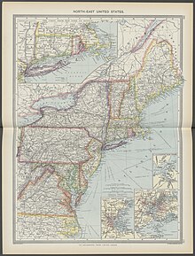
The region is home to the Northeast megalopolis, which includes many of the nation's largest metropolitan areas, including Boston, New York City, and Philadelphia. The megalopolis makes up 67% of the region's total population of 57,609,148. The gross domestic product of the region was $5.1 trillion as of 2022 and contains some of the most developed states based on the Human Development Index, with every state with the exception of Maine above the national average.[15][16] It is also the most densely populated region in the United States, with 320 people per square mile (120 people/km2).[17][10] The U.S. Census Bureau defines the Northeast United States as having a total area of 181,324 sq mi (469,630 km2), making it the smallest region of the United States by total area.
Anthropologists recognize the "Northeastern Woodlands" as one of the cultural regions that existed in the Western Hemisphere at the time of European colonists in the 15th and later centuries. Most did not settle in North America until the 17th century. The cultural area, known as the "Northeastern Woodlands", in addition to covering the entire Northeast U.S., also covered much of what is now Canada and others regions of what is now the eastern United States.[18]
Among the many tribes inhabiting this area were those that made up the Iroquois nations and the numerous Algonquian peoples.[19] In the United States of the 21st century, 18 federally recognized tribes reside in the Northeast.[20] For the most part, the people of the Northeastern Woodlands, on whose lands European fishermen began camping to dry their codfish in the early 1600s, lived in villages, especially after being influenced by agricultural traditions of the Ohio and Mississippi valley societies.[21]
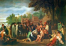
Embarkation of the Pilgrims, an 1857 portrait by Robert Walter WeirPenn's Treaty with the Indians, a 1772 portrait by Benjamin West
All of the U.S. states making up the Northeastern region were among the original Thirteen Colonies, though Maine and Vermont were part of other colonies before the United States became independent in the American Revolution. The two cultural and geographic regions that form parts of the Northeastern region have distinct histories. The first European explorer known to have explored the Atlantic shoreline of the Northeast since the Norse was Giovanni da Verrazzano in 1524. His ship La Dauphine explored the coast from what is now known as Florida to New Brunswick.
Henry Hudson explored the area of present-day New York in 1609 and claimed it for the Netherlands. His journey stimulated Dutch interest, and the area became known as New Netherland. In 1625, the city of New Amsterdam (the location of present-day New York City) was designated the capital of the province.[26] The Dutch New Netherland settlement along the Hudson River and, for a time, the New Sweden settlement along the Delaware River divided the English settlements in the north and the south. In 1664, Charles II of England formally annexed New Netherland and incorporated it into the English colonial empire.[27] The territory became the colonies of New York and New Jersey.[27] New Jersey was originally split into East Jersey and West Jersey until the two were united as a royal colony in 1702.[27]
In 1681, William Penn, who wanted to give Quakers a land of religious freedom, founded Pennsylvania and extended freedom of religion to all citizens.[30]
Penn strongly desired access to the sea for the Province of Pennsylvania and leased what then came to be known as the "Lower Counties on the Delaware" from the Duke.[31] Penn established representative government and briefly combined his two possessions under one General Assembly in 1682.
By 1704, the province of Pennsylvania had grown so large that their representatives wanted to make decisions without the assent of the Lower Counties and the two groups of representatives began meeting on their own, one at Philadelphia, and the other at New Castle, Delaware. Penn and his heirs remained proprietors of both and always appointed the same person Governor for their province of Pennsylvania and their territory of the Lower Counties. The fact that Delaware and Pennsylvania shared the same governor was not unique. From 1703 to 1738, both New York and New Jersey shared a governor.[32] Massachusetts and New Hampshire also shared a governor for some time.[33]
The beginnings of the American Revolutionary War would be in the Northeast, specifically in Massachusetts. The Battles of Lexington and Concord in northeast of Boston would be the first military engagements between the Revolutionaries and the British.[34] Many of the major battles of the revolution would be fought in the Northeast. The British would evacuate Boston in early-1776 and would move to capture New York City.[35]
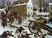
The revolutionaries were pushed to the Delaware River before suddenly moving forward against the British in the Battles of Trenton and Princeton.[35] A stalemate was reached in 1778, between the British and American Revolutionaries and continued until the end of the war in 1783.[36] The war would move to southern states and eventually conclude with the Battle of Yorktown in Virginia.[35]
Following the revolution the Northeast would see small skirmishes like the Whiskey Rebellion in western parts of Pennsylvania.[40] Many northeastern states would continue trading with the British and other European powers. Tensions between the United States and Europe (specifically Britain) would sour in the lead up to the War of 1812.
This caused certain trade merchants to meet in Hartford to propose succeeding from the United States.[41] The War of 1812 would see less fighting in the Northeast and instead more fighting in western and southern areas. A failed invasion of Canada and the occupation of Maine would be some of the major conflicts during the war.[42] The war would end in 1815 and most of the Northeast has not seen any major conflict since then.
After the end of the War of 1812, industry boomed in the Northeast in the early and middle parts of the 19th century. With the construction of railroad and canals crossing the northeast and the rise of western territories and resources from the south, the Northeast experienced the development of new industries and a fast-growing population. Many of the coastal cities, including Boston, New York City, and Philadelphia, served as ocean trade ports for American goods.
By 1860, New York City, based on its present-day boundaries, was the first U.S. city to reach a population exceeding one million.[45] Due to the settlement of the Midwest and Great Plains, agriculture would collapse in the Mid-Atlantic and New England, with many farms being abandoned by the end of the century, returning to rural forest.
Conflicts with the south over the spread of slavery would become a large factor in the start of the American Civil War, between the United States (western and Northeastern states) and the Confederacy (southeastern states). The admission of Maine as a free state in exchange for Missouri becoming a slave state as part of the Missouri Compromise in 1820 would settle the final boundaries of the Northeastern states.[46]
The Mason-Dixon line would be established as the border of slavery, following the border of Pennsylvania and Delaware/Maryland.[47]Abolitionist movements would start in the Northeast and Midwest and would become prominent towards the mid-19th century, these groups advocated the shrinking or banning of slavery in the United States. Some Northeastern states still had small amounts of slaves into the 1850s, though some would ban it during the decade.
The election of 1860 led to the start of the Civil War; southern states succeeded from the United States in late-1860 and early-1861. States like Maryland and Delaware would remain in the union, even with slavery still legal. For the first two years, the eastern theater of the war would remain in Virginia and Maryland, but in 1863 the war would reach its northeastern most extent in Gettysburg, Pennsylvania. The Battle of Gettysburg is considered a turning point in the Civil War, seeing the end of the Confederate push northwards.[48]
While all Northeastern states would remain in the United States during the war, conflicts did arise, like the New York draft riots in 1863.[49] The war would end in 1865 with the United States taking back control of Southern states.
Little Italy in Lower Manhattan, c. 1900Northeastern United States in 1908 from The Harmsworth atlas and Gazetter
Following the Civil War, the Northeast would see a large economic boom and would become one of the most industrialized regions in the world. Many technological innovation would be made in the Northeast during this time. The Second Industrial Revolution would see the northeast grow massively, even more so than before the Civil War. Many cities in the Northeast would explode in population, with cities like Philadelphia and New York climbing over one million people, while other cities like Buffalo, Boston, and Pittsburgh would rise above half a million during this time.
New York City eventually grew to become one of the largest cities in the world by 1900. With the American involvement in both World Wars, the Northeast would become a large base of war production, with the Brooklyn Naval Yard producing many navy ships.[50] Many worker strikes would occur in the states, including the Homestead strike in 1892.[51] Many of these cities would see a peak population and industrial output in the aftermath of World War II in the 1950s.[52]
Starting in the 1950s and continuing into the 21st century, a large industrial decline in the Northeast resulted in a depopulation of many Northeastern cities, many of which had not yet recovered from it into the 21st century. This led to the rise of programs of urban renewal and demolition of large parts of Northeastern cities during the mid and late 20th century.[53] There has also been a large population shift to the Sun Belt states starting in the 1960s.[54]
New York state lost its claim to being the most populated state after it was surpassed by California in the 1970s. Some Northeastern cities, including New York City, have recovered from its decline in the mid-20th century.[45] Many new information and service industries have risen in the northeast, which has led to a boom in the 21st century in some cities in the Northeast like Boston, New York, and Philadelphia. Some other cities like Hartford, Syracuse, and Buffalo still are declining though in the 21st century.[55]Hurricane Sandy would impact much of the northeast in 2012, severely damaging much of the coast and causing flooding inland. The hurricane would directly impact New Jersey and caused large amounts of flooding in New York City.[56]
Although the first settlers of New England were motivated by religion, since the 21st century, New England had become one of the least religious parts of the United States. In a 2009 Gallup survey, less than half of residents in Maine, Massachusetts, New Hampshire, and Vermont reported religion as an important part of their daily life.[57] In a 2010 Gallup survey, less than 30% of residents in Vermont, New Hampshire, Maine, and Massachusetts reported attending church weekly, giving them the lowest church attendance among U.S. states.[58]
The region is often subdivided into New England, the six states east of New York state and the Mid-Atlantic states of New Jersey, New York, and Pennsylvania. This definition has been essentially unchanged since 1880 and is widely used as a standard for data tabulation.[60][61][62][63]
The U.S. Census Bureau has acknowledged the obvious limitations of this definition and the potential merits of a proposal created after the 1950 census,[64] that would include changing regional boundaries to include Delaware, Maryland, and Washington, D.C. with the Mid-Atlantic states, but ultimately decided that "the new system did not win enough overall acceptance among data users to warrant adoption as an official new set of general-purpose State groupings. The previous development of many series of statistics, arranged and issued over long periods of time on the basis of the existing State groupings, favored the retention of the summary units of the current regions and divisions."[65] The U.S. Census Bureau confirmed in 1994 that it would continue to "review the components of the regions and divisions to ensure that they continue to represent the most useful combinations of states and state equivalents."[65]
Many organizations and reference works follow the Census Bureau's definition for the region.[66][67][68] In the history of the United States, the Mason–Dixon line between Pennsylvania (the North) and Maryland (the South) traditionally divided the regions,[69] but in modern times, various entities define the Northeastern United States in somewhat different ways.
The narrowest definitions include only the states of New England.[72] Other more restrictive definitions include New England and New York as part of the Northeast United States, but exclude Pennsylvania and New Jersey.[73][74]
States beyond the Census Bureau definition are included in Northeast Region by various other entities:
The National Park Service includes in their Northeast Region: Delaware, Maryland, West Virginia, and Virginia, though small parts are also in the National Capital Region.[80]
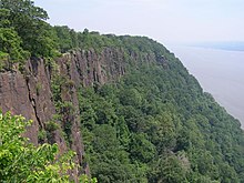
While most of the Northeastern United States lie in the physiographic region of the Appalachian Highlands, some are also part of the Atlantic coastal plain, which extends south to the southern tip of Florida. The coastal plain areas include Cape Cod in Massachusetts, Long Island in New York, and most of New Jersey, and are generally low and flat with sandy soil and marshy land.[10] The highlands, including the Piedmont and the Appalachian Mountains, are heavily forested, ranging from rolling hills to summits greater than 6,000 feet (1,800 m), and pocked with many lakes.[10] The highest peak in the Northeast is Mount Washington in New Hampshire at 6,288 feet (1,917 m).[81]
As of 2012[update], forest-use covered approximately 60% of the Northeastern states, including Delaware, Maryland, and Washington, D.C., about twice the national average. About 11% was cropland and another 4% grassland pasture or range. There is also more urbanized land in the Northeast (12%) than any other region in the U.S.[14]
The climate of the Northeastern United States varies from northernmost state of Maine to its southernmost state in Maryland. The region's climate is influenced by its positional western to eastern flow of weather in the middle latitudes in the United States. Summers are normally warm in northern areas to hot in southern areas. In summer, the building Bermuda High pumps warm and sultry air toward the Northeast, and frequent (but brief) thundershowers are common on hot summer days.
In winter, the subtropical high retreats southeastward, and the polar jet stream moves south bringing colder air masses from up in Canada and more frequent storm systems to the region. Winter often brings both rain and snow as well as surges of both warm and cold air. In the southern part of the Northeast from coastal Rhode Island southwest to eastern Maryland, the Appalachians partially protect these locations from the extreme cold coming from the west and the interior of North America.[82]
The basic climate of the Northeast can be divided into a colder and snowier interior, including western Maryland, most of Pennsylvania, most of North Jersey, Upstate New York, and most of New England, and a milder coastal plain region from Cape Cod and southern Rhode Island southward, including Long Island, Southern Connecticut, New York City, central and southern New Jersey, part of the Pennsylvania portion of the Delaware Valley including Philadelphia, Delaware, and most of Maryland. In the latter region the hardiness zone ranges from 7a to 8a. Annual mean temperatures range from the low-to-mid 50s F from Maryland to southern Connecticut, to the 40s F in most of New York State, New England, and northern Pennsylvania.[82][83][84]
Most of the Northeast has a humid continental climate (Dfa/Dfb/Dc). The northernmost portion of the humid subtropical zone (Cfa/Do) begins at Martha's Vineyard and extreme SW Rhode Island and extends southwestward down the coastal plain to central and southern Maryland. The oceanic climate zone (Cfb/Do) only exists on Block Island and Nantucket and is the only area of the Northeast where all months average between 0 and 22 °C (32 and 72 °F). Cape Cod borders this zone and warm-summer humid continental (Dfb/Dc).
As of the 2020 U.S. census, the population of the region was 57,609,148, representing 17.38% of the nation's total population.[5] With an average of 345.5 people per square mile, the Northeast is 2.5 times as densely populated as the second-most dense region, the South. Since the last century, the U.S. population has been shifting away from the Northeast and Midwest toward the South and West.[87]
The region's racial composition as of 2020 was 64.42% white, 11.51% African American, 0.51% Native American, 7.25% Asian, 0.04% Pacific Islander, 8.17% from other races, and 8.10% from two or more races. Hispanic or Latino of any race were 15.27% of the population.[88] There were 22,418,883 households and 14,189,719 families in 2021. Of the 22,418,883 households, 27.7% included children under the age of 18.[89]
In 2021, the region's the population's age distribution was 20.5% under age 18, 57.36% from 18 to 62, and 22.1% who were 62 years of age or older. The median age was 40.5 years. For every 100 females, there were 96.4 males. For every 100 women ages 18 and over, there were 94.3 men.[90]
The median income for a household in the region in 2021 was $77,142, and the median income for a family was $97,347. About 11.9% of the population were below the poverty line, including 16.0% of those under age 18 and 10.4% of those age 65 or over.[91]
The two U.S. Census Bureau divisions in the Northeast, New England and the Mid-Atlantic, rank second and first respectively among the 9 divisions in population density according to the 2013 population estimate. The South Atlantic region (233.1) was very close behind New England (233.2). Due to the faster growth of the South Atlantic region, it will take over the #2 division rank in population density in the next estimate, dropping New England to 3rd position. New England is projected to retain the number 3 rank for many, many years, as the only other lower-ranked division with even half the population density of New England is the East North Central division (192.1) and this region's population is projected to grow slowly. [d][92]
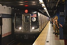
New York City, New York is the most populated city in both the Northeast and the United States. Its population was 8,804,190 in 2020. Its metro area has a population of 20,140,470.[93]
Philadelphia, Pennsylvania is the second-most populated in the Northeast and sixth-largest in the nation. Its population was 1,603,797 in 2020. Its metro area population was 6,228,601.
Boston, Massachusetts is the third-largest city in the Northeast and 24th-largest in the nation. Its population was 675,647 in 2020. Its metro area had a population of 4,941,632.
Newark, New Jersey is the fourth-largest city in the Northeast and 66th-largest in the U.S. Its population was 311,549 in 2020. Its metro area is combined with the New York area.
Pittsburgh, Pennsylvania is the fifth-largest city in the Northeast and 68th-largest in the nation. Pittsburgh is at the western frontier of the Northeast, a short drive from the Ohio border, and is widely regarded as the transition point between the Northeast and Midwest. Its population was 302,971 in 2020. Its metro area has a population of 2,370,930.
Jersey City, New Jersey is the sixth-largest city in the Northeast and 75th-largest in the nation. It had a population of 292,449 in 2020. It sits directly across the Hudson River from New York City.
Buffalo, New York is the seventh-largest city in the Northeast and 78th-largest in the U.S. Its population was 278,349 in 2020. Its metro area had a population of 1,166,902.
Yonkers, New York is the eighth-largest city in the Northeast and 111th-largest city in the U.S. It had a population of 211,569 in 2020. It borders the Bronx, a borough of New York City to its south.
Rochester, New York is the ninth-largest city in the Northeast and the 112th-largest city in the United States. It had a population of 211,328 in 2020. The Rochester metro has a population of 1,090,135.
Worcester, Massachusetts is the tenth-largest city in the Northeast and the 114th-largest city in the United States. It had a population of 206,518 in the 2020 census. It is an edge city of Greater Boston and its metro is combined with it.
This section needs expansion. You can help by adding to it. (February 2023)
As of 2012[update], the Northeast U.S. accounts for approximately 23% of the nation's gross domestic product.[15] Due to its vast population and diverse landscapes, the Northeast has a large and robust economy, ranging from financial services in Manhattan, to agriculture in Central Pennsylvania.
Rural regions and states, including most of Upstate New York, Vermont, New Hampshire, and Maine, rely more on agriculture, logging, mining, and tourism to help boost their local and statewide economies. Many national and state parks in the region generate lots of tourism, especially during fall months. The logging industry is especially prominent in Maine, making up a large part of Northern Maine's economy.
Many Northeastern states have very large economies and are highly developed. As of 2022, the per capita gross domestic products for these states are:
30th Street Station in Philadelphia. Served by all SEPTA Regional Lines, Amtrak, NJ Transit's Atlantic City Line, it is the third-busiest Amtrak station and 11th-busiest train station in North America with over four million passengers in 2019.
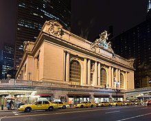
Grand Central Terminal in New York City is served by Metro North and some Long Island Rail trains (beginning in January 2023). Grand Central Terminal had over 67 million annual passengers in 2017 and is the second-busiest train station in the nation and third-busiest in North America.
South Station in Boston is served by southern MBTA commuter lines and Amtrak, and was the seventh-busiest train station in North America with nearly 29 million passengers as of 2017.
North Station in Boston is served by northern MBTA commuter lines and the Downeaster on Amtrak. It had six million MBTA users in 2012 and 152,000 Amtrak passengers in 2021.
Мост Врат Ада (Amtrak) — пересекает Ист-Ривер и Бронкс-Килл , обеспечивает железнодорожное сообщение от вокзала Пенсильвании до Бронкса и Коннектикута. Открыт в 1917 году.
Мост Джорджа Вашингтона (I-95) - пересекает реку Гудзон, соединяя Нью-Йорк и Новую Англию с Нью-Джерси и трассой I-80. Один из самых загруженных переходов в США. Двухэтажный. Открыт в 1931 году.
Мост Трогс-Нек ( I-295 ) пересекает Ист-Ривер, соединяя Бронкс и Новую Англию с Квинсом и Лонг-Айлендом, самый северный переход Ист-Ривер. (в проливе Лонг-Айленд нет постоянных переходов) Открыт в 1961 году.
Мост Таппан-Зи (I-87, I-287 ) - пересекает реку Гудзон, обеспечивая автомагистраль Нью-Йорка и пригородное движение из Рокленд и Вестчестер округов . Альтернатива GW Bridge. Текущий пролет открылся в 2017 году, бывший - в 1955 году.
Мост Ньюбург-Бикон (I-84) - пересекает реку Гудзон, обеспечивая движение транспорта из Пенсильвании и юго-восточного Нью-Йорка через реку в Новую Англию. Открыт в 1963 году.
Мост Q (I-95) - пересекает реку Квиннипиак, обеспечивая транспортное движение из Нью-Хейвена, а также движение, направляющееся в Новую Англию или Нью-Йорк. Текущий пролет открылся в 2012 году, первоначальный - в 1958 году.
Мост Болдуина (I-95) - пересекает реку Коннектикут, обеспечивает движение между штатами и соединяет Старый Сэйбрук с Нью-Лондоном. Открыт в 1948 году.
Радужный мост , соединяющий Нью-Йорк с Канадой недалеко от Ниагарского водопада . Мост Балкли (I-84) - пересекает реку Коннектикут, соединяя движение транспорта в районе Хартфорда через реку. Самый старый межштатный переход в США. Открыт в 1908 году.
Терминал Джерси-Сити — главное железнодорожное и паромное сообщение между Нью-Джерси и Нью-Йорком. Скоростная автомагистраль Кросс-Бронкс (I-95) — это городская автомагистраль, построенная с использованием политики расчистки трущоб в 1950-х и 1960-х годах. Сегодня это одна из самых перегруженных автомагистралей в стране. Это считается основной причиной упадка городов в Бронксе. [ 102 ]
До заселения европейцев большая часть северо-востока была слабо связана тропами коренных американцев, некоторые из которых были включены в дороги и магистрали ранних европейских поселений. Одной из главных ранних дорог была Бостон-Пост-роуд , соединявшая Нью-Йорк и Бостон вдоль побережий Коннектикута и Род-Айленда. [ 108 ] Позже эти дороги будут включены в Королевское шоссе , охватывающее большую часть восточного побережья. Магистрали меньшего размера также будут соединять города на северо-востоке. Эти дороги оказались важными для перемещения товаров через английские колонии в 18 веке, а позже сыграли большую роль в американской революции . [ 109 ]
В начале 19 века в этом регионе наблюдался бум строительства каналов, главным из которых был канал Эри , открытый в 1825 году, соединяющий Великие озера с рекой Гудзон и Атлантическим океаном через западный Нью-Йорк . [ 110 ] Первые железные дороги были построены в конце 1820-х годов, а в середине-конце 19 века их пробег резко увеличился. [ 111 ] Такие места, как Филадельфия, Нью-Йорк, Бостон, Ньюарк и Питтсбург, во время промышленной революции станут крупными водными и железнодорожными узлами, и в них произойдет огромный рост населения и использования. [ 112 ]
Многие крупные реки на северо-востоке, такие как Гудзон и Делавэр, постепенно пересекались по мостам, начиная с 1800-х годов, причем первым постоянным пересечением реки Гудзон к югу от Олбани стал железнодорожный мост Покипси , открытый в 1889 году. [ 113 ] Мост Делар , который соединит Филадельфию с Нью-Джерси, был открыт шесть лет спустя, в 1896 году. [ 114 ] Первым переходом реки Гудзон в Нью-Йорк станет серия туннелей PATH реки Гудзон, открытых в 1908 и 1909 годах. [ 115 ] Первым крупным автомобильным туннелем станет Голландский туннель, открытый в 1927 году. [ 116 ]
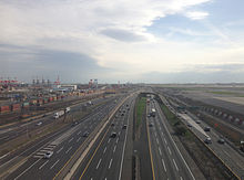
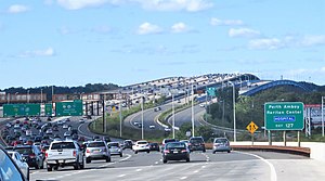
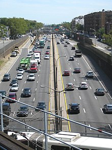
Началом строительства шоссе станут Bronx River Parkway и Long Island Motor Parkway , строительство которых началось в начале 1900-х годов. [ 117 ] Возвышение Роберта Мозеса в Нью-Йорке повлекло за собой строительство множества крупных автодорожных мостов и автомагистралей, пересекающих город и метрополитен. Ист-Ривер-Драйв (в конечном итоге переименованный в ФДР-Драйв) был построен вдоль соответствующей реки на Манхэттене. [ 118 ] В середине 20-го века произойдет появление городских и пригородных автострад и упадок пассажирских и грузовых железных дорог, при этом многие менее используемые пути будут заброшены или разрушены за это время. [ 119 ] будет снесен первоначальный вокзал Пенсильвании . Также в середине 1960-х годов в центре Манхэттена [ 120 ] Строительство скоростной автомагистрали Кросс-Бронкс в Нью-Йорке, Центральной артерии в Бостоне и скоростной автомагистрали Вайн-стрит в Филадельфии разрушило многие кварталы, где проживают этнические меньшинства, во имя обновления городов . [ 121 ] [ 122 ] [ 123 ] [ 124 ] В то время было предложено множество других автомагистралей, таких как Скоростная автомагистраль Нижнего Манхэттена и Внутренний пояс в Бостоне, которые не были построены из-за ожесточенных восстаний на шоссе и роста затрат. [ 106 ] [ 124 ] [ 125 ] После крупных восстаний на шоссе и роста экологических проблем к 1990-м годам на северо-востоке проекты строительства новых автомагистралей и межштатных дорог в основном были отменены или сокращены.
Несмотря на отсутствие новых крупных дорожных проектов на северо-востоке, население региона продолжает расти, что приводит к появлению альтернативных видов транспорта, таких как полосы для грузовых автомобилей или пригородные железные дороги . Это привело к тому, что на северо-востоке наблюдается один из самых высоких процентов использования транзита в Северной Америке, а железная дорога Лонг-Айленда является наиболее используемой пригородной железной дорогой на континенте. [ 126 ] Единственным исключением были « Большие раскопки» , крупный дорожный проект, который должен был снести бывшую надземную Центральную артерию (I-93) и вместо этого построить туннель (и расширить его). Также будет построен новый мост через реку Чарльз и туннель Теда Уильямса (I-90). В конечном итоге это станет одним из самых дорогостоящих строительных проектов в мире, стоимость которого составит 21 миллиард долларов с учетом инфляции 2020 года. [ 127 ] Путь бывшего шоссе станет Rose Kennedy Greenway большим общественным парком ( . Скоростная автомагистраль Шеридан бывшая I-895) также была перестроена в бульвар в конце 2010-х годов. [ 128 ] Рочестер, штат Нью-Йорк, снес Внутреннюю петлю из-за низкого трафика, чтобы воссоединить районы в центре города и создать пространство для застройки. [ 129 ]
Этот раздел нуждается в расширении . Вы можете помочь, добавив к нему . ( июль 2021 г. )
Один географ, Уилбур Зелински , утверждает, что северо-восточному региону не хватает единой культурной идентичности. [ 17 ] но служил «очагом культуры» для остальной части нации. [ 130 ] Несколько гораздо меньших географических регионов на северо-востоке имеют выраженную культурную самобытность. [ 17 ]
Согласно опросу Gallup 2009 года , северо-восточные штаты отличаются от большей части остальной части США религиозной принадлежностью, что в целом отражает потомки иммиграционных моделей конца 19-го и начала 20-го веков, при этом многие католики приезжают из Ирландии, Италии, французской Канады. - Квебек, Португалия и восточно-центральная Европа. Массачусетс, Род-Айленд, Нью-Йорк и Нью-Джерси — единственные штаты в стране, где католиков больше , чем протестантов и представителей других христианских конфессий . Более 20% респондентов в штатах Мэн, Нью-Гэмпшир и Вермонт заявили об отсутствии религиозной принадлежности. [ 132 ] По сравнению с другими регионами США, по состоянию на 2015 год на северо-востоке, а также на северо-западе Тихого океана была самая низкая посещаемость регулярных религиозных служб и наименьшее количество людей, для которых религия является важной частью их повседневной жизни. [ 133 ]
Северо-восточный регион является домом для многочисленных профессиональных спортивных клубов лиг «Большой четверки» (НФЛ, НБА, НХЛ и MLB). [ 134 ] среди них более 100 чемпионатов. [ 135 ]
Северо-восток Соединенных Штатов, как правило, голосовал за республиканцев на федеральных выборах в первой половине 20-го века, но с 1990-х годов этот регион превратился в самый демократический регион в стране, наряду с Западным побережьем . [ 13 ] Результаты опроса Gallup 2008 года показали, что восемь из десяти ведущих штатов-демократов расположены в этом регионе, причем каждый северо-восточный штат имеет преимущество принадлежности к Демократической партии не менее десяти пунктов. [ 137 ] В следующей таблице показана поддержка демократов на северо-востоке по сравнению с остальной частью страны. [ 138 ]
Год
% голосов президента
% мест в Сенате
% мест в доме
Северо-восток
Остаток
Северо-восток
Остаток
Северо-восток
Остаток
2000
57.6
47.5
60.0
46.3
59.6
45.7
2002
60.0
45.0
58.3
44.7
2004
57.1
47.3
60.0
40.0
59.5
43.0
2006
75.0
45.0
73.8
48.3
2008
60.7
52.0
80.0
52.5
81.0
52.9
2010
75.0
47.5
67.9
38.5
Следующая таблица результатов президентских выборов в США с 1920 года показывает, что за последние семь президентских выборов только три северо-восточных штата поддержали кандидата от республиканской партии (Нью-Гэмпшир проголосовал за Джорджа Буша в 2000 году; 2-й избирательный округ Пенсильвании и штата Мэн проголосовал за Дональда Трампа). в 2016 году). [ 139 ] 2004 год — пока единственные выборы в истории США, на которых победитель не выиграл ни в одном северо-восточном штате. Записи, выделенные жирным шрифтом, указывают на то, что кандидат от партии также победил на всеобщих выборах.
В следующей таблице показана разбивка партийной принадлежности губернаторов, генеральных прокуроров, законодательных палат штатов и делегаций Конгресса США в северо-восточных штатах по состоянию на май 2020 года. [update]. (Демографические данные отражают данные о регистрации партий из статистики зарегистрированных избирателей этого штата.)
^ Термин «Восточное побережье» почти исключительно используется для обозначения северо-восточного мегаполиса . Как указано в многочисленных словарях и энциклопедиях, включая Оксфордский словарь английского языка и Словарь американского наследия, «восточное побережье» в первую очередь относится к региону между Вашингтоном на юге и Бостоном на севере. [ 7 ] [ 8 ] [ 9 ] Исторически этот термин всегда обозначал Северо-Восток.
^ Бюро переписи населения США реорганизовало свои административные единицы, и его региональные офисы не охватывают регионы переписи (самый северо-восточный региональный офис со штаб-квартирой в Нью-Йорке охватывает Новую Англию, Нью-Йорк, Нью-Джерси и Пуэрто-Рико). [ 59 ]
^ На основе прогнозов численности населения Бюро переписи населения США до 2030 года (при условии постоянной площади суши) плотность населения в регионе Южной Атлантики значительно увеличится до 294,6 человек на милю. 2 , плотность Новой Англии увеличится до 249,2 миль на милю. 2 а восточно-северно-центральное подразделение увеличится лишь незначительно до 200,2/миль. 2 . По прогнозам, подразделением с 5-м местом по плотности будет Восточно-Южно-Центральное со скоростью 111,6/миль. 2 . [ 92 ]
^ Барревельд, доктора. Дирк Дж. (2001). От Нового Амстердама до Нью-Йорка: основание Нью-Йорка голландцами в июле 1625 года . Нью-Йорк: Пресса Клуба писателей. ISBN 978-0-595-19890-0 .
^ Боатнер, Марк М. III (1994). Энциклопедия американской революции (3-е изд.). Механиксбург, Пенсильвания: Stackpole Books. ISBN 0-8117-0578-1 . OCLC 29595553 .
^ Джиллсон, Кэлвин С. (2009). Американское правительство: политическое развитие и институциональные изменения (5-е изд.). Нью-Йорк: Рутледж. ISBN 978-0-415-99570-2 . OCLC 263497894 .
^ Беркин, Кэрол (2017). Суверенный народ: кризисы 1790-х годов и рождение американского национализма . Нью-Йорк, штат Нью-Йорк. ISBN 978-0-465-06088-7 . OCLC 958798629 . {{cite book}}: CS1 maint: отсутствует местоположение издателя ( ссылка )
^ Буэль, Ричард (2005). Америка на грани: как политическая борьба из-за войны 1812 года едва не уничтожила молодую республику . Нью-Йорк, штат Нью-Йорк: Пэлгрейв Макмиллан. ISBN 1-4039-6238-3 . OCLC 55510543 .
^ Памела Гоян Киттлер; Кэтрин П. Сучер (2008). Еда и культура . Cengage Обучение . п. 475. ИСБН 978-0-495-11541-0 . Архивировано из оригинала 26 января 2021 года . Проверено 2 ноября 2020 г. (Большинство) демографических данных и данных о потреблении продуктов питания представлены в этом формате для четырех регионов.
^ «О Совете» . Северо-восточный региональный совет Министерства обороны. Архивировано из оригинала 23 сентября 2013 года . Проверено 21 сентября 2013 г.
^ Военное предпринимательство и технологические изменения: взгляды на американский опыт . Мерритт Роу Смит. Кембридж, Массачусетс: MIT Press. 1985. ISBN 0-262-19239-Х . OCLC 11676079 . {{cite book}}: CS1 maint: другие ( ссылка )
^ Зелинский, Уилбур (декабрь 1955 г.). «Некоторые проблемы распространения родовых терминов в топонимах северо-востока США». Анналы Ассоциации американских географов . 45 (4): 319. doi : 10.1111/j.1467-8306.1955.tb01491.x .
^ Райтер, Ховард Л. и Джеффри М. Стоункэш (2011). Контрперестройка: политические изменения на северо-востоке США . Издательство Кембриджского университета. ISBN 978-1-139-49313-0 .
Arc.Ask3.Ru Номер скриншота №: 5b2e61a246d9ad923818b666b314af48__1722119400 URL1:https://arc.ask3.ru/arc/aa/5b/48/5b2e61a246d9ad923818b666b314af48.html Заголовок, (Title) документа по адресу, URL1: Northeastern United States - Wikipedia
Данный printscreen веб страницы (снимок веб страницы, скриншот веб страницы), визуально-программная копия документа расположенного по адресу URL1 и сохраненная в файл, имеет: квалифицированную, усовершенствованную (подтверждены: метки времени, валидность сертификата), открепленную ЭЦП (приложена к данному файлу), что может быть использовано для подтверждения содержания и факта существования документа в этот момент времени. Права на данный скриншот принадлежат администрации Ask3.ru, использование в качестве доказательства только с письменного разрешения правообладателя скриншота. Администрация Ask3.ru не несет ответственности за информацию размещенную на данном скриншоте. Права на прочие зарегистрированные элементы любого права, изображенные на снимках принадлежат их владельцам. Качество перевода предоставляется как есть. Любые претензии, иски не могут быть предъявлены. Если вы не согласны с любым пунктом перечисленным выше, вы не можете использовать данный сайт и информация размещенную на нем (сайте/странице), немедленно покиньте данный сайт. В случае нарушения любого пункта перечисленного выше, штраф 55! (Пятьдесят пять факториал, Денежную единицу (имеющую самостоятельную стоимость) можете выбрать самостоятельно, выплаичвается товарами в течение 7 дней с момента нарушения.)


 New York City, New York is the most populated city in both the Northeast and the United States. Its population was 8,804,190 in 2020. Its metro area has a population of 20,140,470.[93]
 Philadelphia, Pennsylvania is the second-most populated in the Northeast and sixth-largest in the nation. Its population was 1,603,797 in 2020. Its metro area population was 6,228,601.
 Boston, Massachusetts is the third-largest city in the Northeast and 24th-largest in the nation. Its population was 675,647 in 2020. Its metro area had a population of 4,941,632.
 Newark, New Jersey is the fourth-largest city in the Northeast and 66th-largest in the U.S. Its population was 311,549 in 2020. Its metro area is combined with the New York area.
 Pittsburgh, Pennsylvania is the fifth-largest city in the Northeast and 68th-largest in the nation. Pittsburgh is at the western frontier of the Northeast, a short drive from the Ohio border, and is widely regarded as the transition point between the Northeast and Midwest. Its population was 302,971 in 2020. Its metro area has a population of 2,370,930.
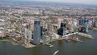 Jersey City, New Jersey is the sixth-largest city in the Northeast and 75th-largest in the nation. It had a population of 292,449 in 2020. It sits directly across the Hudson River from New York City.
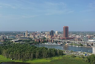 Buffalo, New York is the seventh-largest city in the Northeast and 78th-largest in the U.S. Its population was 278,349 in 2020. Its metro area had a population of 1,166,902.
 Yonkers, New York is the eighth-largest city in the Northeast and 111th-largest city in the U.S. It had a population of 211,569 in 2020. It borders the Bronx, a borough of New York City to its south.
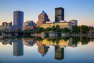 Rochester, New York is the ninth-largest city in the Northeast and the 112th-largest city in the United States. It had a population of 211,328 in 2020. The Rochester metro has a population of 1,090,135.
 Worcester, Massachusetts is the tenth-largest city in the Northeast and the 114th-largest city in the United States. It had a population of 206,518 in the 2020 census. It is an edge city of Greater Boston and its metro is combined with it.