Огайо

Огайо | |
|---|---|
| штат Огайо | |
| Прозвища : Штат Бакай; Место рождения авиации; Сердце всего этого | |
| Девиз : | |
| Гимн: « Прекрасный Огайо ». [ 2 ] | |
 Map of the United States with Ohio highlighted | |
| Country | United States |
| Admitted to the Union | March 1, 1803[3] (17th, declared retroactively on August 7, 1953[4]) |
| Capital (and largest city) | Columbus[5][6] |
| Largest county or equivalent | Franklin County, Ohio |
| Largest metro and urban areas | Greater Cleveland (combined and urban) Cincinnati (metro) Columbus (metro) (see footnotes)[a] |
| Government | |
| • Governor | Mike DeWine (R) |
| • Lieutenant Governor | Jon Husted (R) |
| Legislature | General Assembly |
| • Upper house | Senate |
| • Lower house | House of Representatives |
| Judiciary | Supreme Court of Ohio |
| U.S. senators | Sherrod Brown (D) JD Vance (R) |
| U.S. House delegation | 10 Republicans 5 Democrats (list) |
| Area | |
| • Total | 44,825 sq mi (116,096 km2) |
| • Land | 40,948 sq mi (106,156 km2) |
| • Water | 3,877 sq mi (10,040 km2) 8.7% |
| • Rank | 34th |
| Dimensions | |
| • Length | 220 mi (355 km) |
| • Width | 220 mi (355 km) |
| Elevation | 850 ft (260 m) |
| Highest elevation | 1,549 ft (472 m) |
| Lowest elevation | 455 ft (139 m) |
| Population (2023) | |
| • Total | 11,785,935[9] |
| • Rank | 7th |
| • Density | 282/sq mi (109/km2) |
| • Rank | 10th |
| • Median household income | $54,021[10] |
| • Income rank | 36th |
| Demonym(s) | Ohioan; Buckeye[11] (colloq.) |
| Language | |
| • Official language | De jure: None De facto: English |
| • Spoken language | English 93.3% Spanish 2.2% Other 4.5%[12] |
| Time zone | UTC– 05:00 (Eastern) |
| • Summer (DST) | UTC– 04:00 (EDT) |
| USPS abbreviation | OH[13] |
| ISO 3166 code | US-OH |
| Traditional abbreviation | O., Oh. |
| Latitude | 38°24′ N to 41°59′ N |
| Longitude | 80°31′ W to 84°49′ W |
| Website | ohio |


| List of state symbols | |
|---|---|
 | |
 | |
| Slogan | The Heart Of It All |
| Living insignia | |
| Amphibian | Spotted salamander |
| Bird | Cardinal (1933)[2] |
| Flower |
|
| Fruit | Pawpaw |
| Insect | Ladybug (1975)[2] |
| Mammal | White-tailed deer (1987)[2] |
| Reptile | Black racer snake (1995)[2] |
| Tree | Buckeye (1953)[2] |
| Inanimate insignia | |
| Beverage | Tomato juice (1965)[2] |
| Fossil | Isotelus maximus, a trilobite (1985)[2] |
| Gemstone | Ohio flint (1965)[2] |
| State route marker | |
 | |
| State quarter | |
 Released in 2002 | |
| Lists of United States state symbols | |
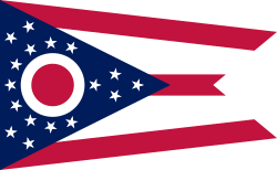
Огайо ( / oʊ ˈ h aɪ . oʊ / ох -хй -ох ) [ 14 ] — штат в регионе Среднего США Запада . Огайо граничит с озером Эри на севере, Пенсильванией на востоке, Западной Вирджинией на юго-востоке, Кентукки на юго-западе, Индианой на западе и Мичиганом на северо-западе. Из 50 штатов США это 34-й по величине по площади . С населением почти 11,8 миллиона человек Огайо является седьмым по численности населения и десятым по плотности населения штатом . Ее столица и самый густонаселенный город — Колумбус , а также другие крупные населенные пункты, включая Кливленд , Цинциннати , Дейтон , Акрон и Толедо . Огайо прозвали «Штатом Бакай» из-за его деревьев , а жители Огайо также известны как «Бакай». [ 11 ] Его флаг — единственный непрямоугольный флаг среди всех штатов США.
Огайо получил свое название от реки Огайо , образующей его южную границу, которая, в свою очередь, произошла от сенека слова ohiːyo' , означающего «хорошая река», «великая река» или «большой ручей». [ 15 ] [ 16 ] Государство было домом для нескольких древних коренных цивилизаций, а люди жили здесь еще в 10 000 году до нашей эры. Он возник на землях к западу от Аппалачей , которые оспаривались различными местными племенами и европейскими колонистами с 17 века до северо-западных индейских войн конца 18 века. Огайо был отделен от Северо-Западной территории , первой границы новых Соединенных Штатов, став 17-м штатом, принятым в Союз 1 марта 1803 года, и первым в соответствии с Северо-Западным постановлением . [3][17] It was the first post-colonial free state admitted to the union and became one of the earliest and most influential industrial powerhouses during the 20th century. Although it has transitioned to a more information- and service-based economy in the 21st century, it remains an industrial state, ranking seventh in GDP as of 2019[update],[18] with the third-largest manufacturing sector and second-largest automobile production.[19]
Modeled on its federal counterpart, Ohio's government is composed of the executive branch, led by the governor; the legislative branch, consisting of the bicameral Ohio General Assembly; and the judicial branch, led by the state Supreme Court. Ohio occupies 15 seats in the United States House of Representatives, the seventh-largest delegation.[20] Seven presidents of the United States have come from Ohio, earning it the moniker "the Mother of Presidents".[21]
History
Indigenous settlement

Archeological evidence of spear points of both the Folsom and Clovis types indicate that the Ohio Valley was inhabited by nomadic people as early as 13,000 BC.[22] These early nomads disappeared from Ohio by 1,000 BC.[22] Between 1,000 and 800 BC, the sedentary Adena culture emerged. The Adena established "semi-permanent" villages because they domesticated plants, including sunflowers, and "grew squash and possibly corn"; with hunting and gathering, this cultivation supported more settled, complex villages.[23] The most notable remnant of the Adena culture is the Great Serpent Mound, located in Adams County, Ohio.[23]
Around 100 BC, the Adena evolved into the Hopewell people, who were also mound builders. Their complex, large and technologically sophisticated earthworks can be found in modern-day Marietta, Newark, and Circleville.[24] They were also a prolific trading society, their trading network spanning a third of the continent.[25] The Hopewell disappeared from the Ohio Valley about 600 AD. The Mississippian culture rose as the Hopewell culture declined. Many Siouan-speaking peoples from the plains and east coast claim them as ancestors and say they lived throughout the Ohio region until approximately the 13th century.[26]
There were three other cultures contemporaneous with the Mississippians: the Fort Ancient people, the Whittlesey Culture[26] and the Monongahela Culture.[27] All three disappeared in the 17th century. Their origins are unknown. The Shawnees may have absorbed the Fort Ancient people.[26] It is also possible that the Monongahela held no land in Ohio during the Colonial Era. The Mississippian culture was close to and traded extensively with the Fort Ancient people.

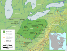
Indians in the Ohio Valley were greatly affected by the aggressive tactics of the Iroquois Confederation, based in central and western New York.[28] After the Beaver Wars in the mid-17th century, the Iroquois claimed much of the Ohio country as hunting and, more importantly, beaver-trapping ground. After the devastation of epidemics and war in the mid-17th century, which largely emptied the Ohio country of Indigenous people[dubious – discuss] by the mid-to-late 17th century, the land gradually became repopulated by the mostly Algonquian. Many of these Ohio-country nations were multiethnic (sometimes multi-linguistic) societies born out of the earlier devastation brought about by disease,[clarification needed] war, and subsequent social instability. They subsisted on agriculture (corn, sunflowers, beans, etc.) supplemented by seasonal hunts. By the 18th century, they were part of a larger global economy brought about by European entry into the fur trade.[29]
Some of the Indigenous nations that historically inhabited Ohio include the Iroquoian,[c] the Algonquian,[d] and the Siouan.[e][30][31] Ohio country was also the site of Indian massacres, such as the Yellow Creek massacre and the Gnadenhutten massacre.[32] After the War of 1812, when Natives suffered serious losses such as at Tippecanoe, most Native tribes either left Ohio or had to live on only limited reservations. By 1842, all remaining Natives were forced out of the state.[33]
Colonial and Revolutionary eras
During the 18th century, the French set up a system of trading posts to control the fur trade in the region. Beginning in 1754, the Kingdom of France and Kingdom of Great Britain fought in the French and Indian War, with various Native American tribes on each side. As a result of the Treaty of Paris, the French ceded control of Ohio and the remainder of the Old Northwest to Great Britain in 1763.[34]
Before the American Revolution, Britain thinly exercised sovereignty over Ohio Country by lackadaisical garrisoning of the French forts.[f] Just beyond Ohio Country was the great Miami capital of Kekionga, which became the center of British trade and influence in Ohio Country and throughout the future Northwest Territory. By the Royal Proclamation of 1763, British lands west of Appalachia were forbidden to settlement by colonists.[35] The Treaty of Fort Stanwix in 1768 explicitly reserved lands north and west of the Ohio as Native lands.[36] British military occupation in the region contributed to the outbreak of Pontiac's War in 1763.[37] Ohio tribes participated in the war until an armed expedition in Ohio led by Brigadier General Henry Bouquet brought about a truce. Another colonial military expedition into the Ohio Country in 1774 brought Lord Dunmore's War, kicked off by the Yellow Creek massacre in Ohio, to a conclusion. In 1774, Britain passed the Quebec Act, which formally annexed Ohio and other western lands to the Province of Quebec in order to provide a civil government and to centralize British administration of the Montreal-based fur trade.[38] The prohibition of settlement west of the Appalachians remained, contributing to the American Revolution.[39]
By the start of the American Revolutionary War, the movement of Natives and Americans between the Ohio Country and Thirteen Colonies had resulted in tension. Fort Pitt in Pennsylvania had become the main fort where expeditions into Ohio started. Intrusions into the area included General Edward Hand's 1778 movement of 500 Pennsylvania militiamen from Fort Pitt towards Mingo towns on the Cuyahoga River, where the British stored military supplies which they distributed to Indian raiding parties;[40] Colonel Daniel Brodhead's invasion in 1780 and destruction of the Lenape Indian capital of Coshocton;[41] a detachment of one hundred of George Rogers Clark's troops that were ambushed near the Ohio River by Indians led by Joseph Brant in the same year; a British and Native American attack on the U.S.' Fort Laurens;[42] and the 1782 detainment and murder of 96 Moravian Lenape pacifists by Pennsylvania militiamen in the Gnadenhutten massacre.[43][44]
The western theatre never had a decisive victor. In the Treaty of Paris in 1783, Britain ceded all claims to Ohio Country to the new United States after its victory in the American Revolutionary War.[45][46]
Northwest Territory
The United States created the Northwest Territory under the Northwest Ordinance of 1787.[47] Slavery was not permitted in the new territory. Settlement began with the founding of Marietta by the Ohio Company of Associates, which had been formed by a group of American Revolutionary War veterans. Following the Ohio Company, the Miami Company (also referred to as the "Symmes Purchase") claimed the southwestern section, and the Connecticut Land Company surveyed and settled the Connecticut Western Reserve in present-day Northeast Ohio. Territorial surveyors from Fort Steuben began surveying an area of eastern Ohio called the Seven Ranges at about the same time.
The old Northwest Territory originally included areas previously known as Ohio Country and Illinois Country. As Ohio prepared for statehood, the Indiana Territory was created, reducing the Northwest Territory to approximately the size of present-day Ohio plus the eastern half of the Lower Peninsula of Michigan and the eastern tip of the Upper Peninsula and a sliver of southeastern Indiana called "The Gore".
The coalition of Native American tribes, known as the Western Confederacy, was forced to cede extensive territory, including much of present-day Ohio, in the Treaty of Greenville in 1795.
Under the Northwest Ordinance, areas could be defined and admitted as states once their population reached 60,000. Although Ohio's population was only 45,000 in December 1801, Congress determined that it was growing rapidly enough and accelerated the process via the Enabling Act of 1802. In regard to the Leni Lenape natives, Congress decided that 10,000 acres on the Muskingum River in the present state of Ohio would "be set apart and the property thereof be vested in the Moravian Brethren ... or a society of the said Brethren for civilizing the Indians and promoting Christianity".[48]
Rufus Putnam, the "Father of Ohio"

Rufus Putnam served in important military capacities in both the French and Indian War and the American Revolutionary War. He was one of the most highly respected men in the early years of the United States.[49]
In 1776, Putnam created a method of building portable fortifications, which enabled the Continental Army to drive the British from Boston. George Washington was so impressed that he made Putnam his chief engineer. After the war, Putnam and Manasseh Cutler were instrumental in creating the Northwest Ordinance, which opened up the Northwest Territory for settlement. This land was used to serve as compensation for what was owed to Revolutionary War veterans. Putnam organized and led the Ohio Company of Associates, who settled at Marietta, Ohio, where they built a large fort, Campus Martius.[50][51][52] He set substantial amounts of land aside for schools. In 1798, he created the plan for the construction of the Muskingum Academy (now Marietta College). In 1780, the directors of the Ohio Company appointed him superintendent of all its affairs relating to the settlement north of the Ohio River. In 1796, President George Washington commissioned him as Surveyor-General of United States Lands. In 1788, he served as a judge in the Northwest Territory's first court. In 1802, he served in the convention to form a constitution for the State of Ohio.[53][54][55]
Statehood and early years
On February 19, 1803, U.S. President Thomas Jefferson signed an act of Congress that approved Ohio's boundaries and constitution.[56] But Congress had not passed a formal resolution admitting Ohio as the 17th state. Although no formal resolution of admission was required, when the oversight was discovered in 1953, as Ohio began preparations for celebrating its sesquicentennial, Ohio congressman George H. Bender introduced a bill in Congress to admit Ohio to the Union retroactive to March 1, 1803, the date on which the Ohio General Assembly first convened.[57] At a special session at the old state capital in Chillicothe, the Ohio state legislature approved a new petition for statehood, which was delivered to Washington, D.C., on horseback, and approved that August.[57][58][59]
Ohio has had three capital cities: Chillicothe, Zanesville, and Columbus. Chillicothe was the capital from 1803 to 1810. The capital was then moved to Zanesville for two years as part of a state legislative compromise to get a bill passed. The capital was then moved back to Chillicothe from 1812 to 1816. Finally, the capital was moved to Columbus, to be near the state's geographic center.
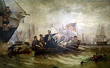
Although many Native Americans migrated west to evade American encroachment, others remained in the state, sometimes assimilating in part. Starting around 1809, the Shawnee pressed resistance to encroachment again. Under Chief Tecumseh, Tecumseh's War officially began in Ohio in 1811. When the War of 1812 began, the British decided to attack from Upper Canada into Ohio and merge their forces with the Shawnee. This continued until Tecumseh was killed at the Battle of the Thames in 1813. Most of the Shawnee, excluding the Pekowi in Southwest Ohio, were forcibly relocated west.[60] Ohio played a key role in the War of 1812, as it was on the front line in the Western theater and the scene of several notable battles both on land and in Lake Erie. On September 10, 1813, the Battle of Lake Erie, one of the major battles, took place near Put-in-Bay, Ohio. The British eventually surrendered to Oliver Hazard Perry.
Ultimately, after the U.S. government used the Indian Removal Act of 1830 to force countless Native American tribes on the Trail of Tears, where all the southern states except for Florida were successfully emptied of Native peoples, the government panicked because most tribes did not want to be forced out of their own lands. Fearing further wars between Native tribes and American settlers, they pushed all remaining Native tribes in the East to migrate west against their will, including all remaining tribes in Ohio.[61][62]
In 1835, Ohio fought with the Michigan Territory in the Toledo War, a mostly bloodless boundary war over the Toledo Strip. Only one person was injured in the conflict. Congress intervened, making Michigan's admittance as a state conditional on ending the conflict. In exchange for giving up its claim to the Toledo Strip, Michigan was given the western two-thirds of the Upper Peninsula, in addition to the eastern third, which was already considered part of the territory.
Civil War and industrialization

Ohio's central position and its population gave it an important place in the Civil War. The Ohio River was a vital artery for troop and supply movements, as were Ohio's railroads. Ohio's industry made it one of the most important states in the Union during the war. It contributed more soldiers per capita than any other state in the Union. In 1862, the state's morale was badly shaken in the aftermath of the Battle of Shiloh, a costly victory in which Ohio forces suffered 2,000 casualties.[63] Later that year, when Confederate troops under the leadership of Stonewall Jackson threatened Washington, D.C., Ohio governor David Tod recruited 5,000 volunteers to provide three months of service.[64] From July 13 to 26, 1863, towns along the Ohio River were attacked and ransacked in Morgan's Raid, starting in Harrison in the west and culminating in the Battle of Salineville near West Point in the far east. While this raid was overall insignificant to the Confederacy, it aroused fear among people in Ohio and Indiana as it was the furthest advancement of troops from the South in the war.[65] Almost 35,000 Ohioans died in the conflict, and 30,000 were physically wounded.[66] By the end of the Civil War, the Union's top three generals—Ulysses S. Grant, William Tecumseh Sherman, and Philip Sheridan—were all from Ohio.[67]
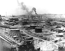
During much of the 19th century, industry was rapidly introduced to complement an existing agricultural economy. One of the first iron manufacturing plants, Hopewell Furnace, opened near Youngstown in 1804. By the mid-19th century, 48 blast furnaces were operating in Ohio, most in the southern part of the state.[68] Discovery of coal deposits aided the further development of Ohio's steel industry, and by 1853 Cleveland was the nation's third-largest iron and steel producer. The first Bessemer converter was purchased by the Cleveland Rolling Mill Company, which became part of the U.S. Steel Corporation after the merger of Federal Steel Company and Carnegie Steel, the first billion-dollar American corporation.[68] The first open-hearth furnace used for steel production was constructed by the Otis Steel Company in Cleveland, and by 1892, Ohio was the second-largest steel-producing state, behind Pennsylvania.[68] Republic Steel was founded in Youngstown in 1899 and was at one point the nation's third-largest producer. Armco, now AK Steel, was founded in Middletown in 1899.
20th century
The state legislature officially adopted the flag of Ohio on May 9, 1902.[69] Dayton natives Orville and Wilbur Wright made four brief flights at Kitty Hawk, North Carolina, on December 17, 1903, inventing the first successful airplane.[70] Ohio was hit by its greatest natural disaster in the Great Flood of 1913, resulting in at least 428 fatalities and hundreds of millions of dollars in property damage, particularly around the Great Miami River basin.[71]
The National Football League was originally founded in Canton, Ohio in 1920 as the American Professional Football Conference.[72] It included Ohio League teams in five Ohio cities (Akron, Canton, Cleveland, Columbus, and Dayton), none of which still exist. The first official game occurred on October 3, 1920, when the Dayton Triangles beat the Columbus Panhandles 14–0 in Dayton.[73] Canton was enshrined as the home of the Pro Football Hall of Fame in 1963.[74]

During the 1930s, the Great Depression struck the state hard. By 1933, more than 40% of factory workers and 67% of construction workers were unemployed in Ohio.[75] Approximately 50% of industrial workers in Cleveland and 80% in Toledo became unemployed, with the state unemployment rate reaching a high of 37.3%.[75] American Jews watched the rise of Nazi Germany with apprehension. Cleveland residents Jerry Siegel and Joe Shuster created the Superman comic character in the spirit of the Jewish golem. Many of their comics portrayed Superman fighting and defeating the Nazis.[76][77] Approximately 839,000 Ohioans served in the U.S. armed forces during World War II, of whom over 23,000 died or were missing in action.[78]
Artists, writers, musicians and actors developed in the state throughout the 20th century and often moved to other cities that were larger centers for their work. They included Zane Grey, Milton Caniff, George Bellows, Art Tatum, Roy Lichtenstein, and Roy Rogers. Alan Freed, who emerged from the swing dance culture in Cleveland, hosted the first live rock 'n roll concert in Cleveland in 1952. Famous filmmakers include Steven Spielberg, Chris Columbus and the original Warner Brothers, who set up their first movie theatre in Youngstown before the company relocated to California. The state produced many popular musicians, including Dean Martin, Doris Day, The O'Jays, Marilyn Manson, Dave Grohl, Devo, Macy Gray and The Isley Brothers.
Two Ohio astronauts completed significant milestones in the space race in the 1960s: John Glenn becoming the first American to orbit the Earth, and Neil Armstrong becoming the first human to walk on the Moon. In 1967, Carl Stokes was elected mayor of Cleveland and became the first African American mayor of one of the nation's 10 most populous cities.[79]
In 1970, an Ohio Army National Guard unit fired at students during an antiwar protest at Kent State University, killing four and wounding nine. The Guard had been called onto campus after several protests in and around campus became violent, including a riot in downtown Kent and the burning of an ROTC building. The main cause of the protests was the United States' invasion of Cambodia during the Vietnam War.[80]
Ohio was an important state in the developing ties between the United States and the People's Republic of China in the late 1970s and early 1980s.[81]: 59 Relations between the two countries normalized in 1979, during the second term of Ohio governor Jim Rhodes.[81]: 112 Rhodes sought to encourage economic ties, viewing China as a potential market for Ohio machinery exports.[81]: 112 In July 1979, Rhodes led a State of Ohio Trade Mission to China.[81]: 112 The trip resulted in developing economic ties, a sister state-province relationship with Hubei province, long-running Chinese exhibitions at the Ohio State Fair, and major academic exchanges between Ohio State University and Wuhan University.[81]: 113 Beginning in the 1980s, the state entered into international economic and resource cooperation treaties and organizations with other Midwestern states, as well as New York, Pennsylvania, Ontario, and Quebec, including the Great Lakes Charter, Great Lakes Compact, and the Council of Great Lakes Governors.
21st century
Ohio's economy has undergone significant change in the 21st century, as the trend of deindustrialization has greatly impacted the American Midwest and the Rust Belt. Manufacturing in the Midwest experienced a stark decline during the early 21st century,[82] a trend that greatly impacted Ohio. From 1990 to 2019, it lost over 300,000 manufacturing jobs, but added over 1,000,000 non-manufacturing jobs.[82] Coinciding with this decline, Ohio has seen a large decline in union membership: 17.4% of Ohioan workers were union members in 2000, while 12.8% were union members in 2022.[83]
In the wake of these economic changes, Ohio's state government has looked to promoting new industries to offset manufacturing losses, such as the production of solar energy and electric vehicles.[84] One major program the state government launched was the "Third Frontier" program, created during the governorship of Bob Taft, which aims to increase investment in Ohio and boost its technology sector.[85] As of 2010, the Ohio Department of Development attributes the creation of 9,500 jobs to this program, with an average of salary of $65,000,[86] while having a $6.6 billion economic impact with a return on investment of 9:1.[86] In 2010 the state won the International Economic Development Council's Excellence in Economic Development Award, celebrated as a national model of success.[citation needed]
Many of the state's former industrial centers turned to new industries, including Akron as a center for polymer and biomedical research, Cincinnati as the state's largest mercantile hub,[87][better source needed] Columbus as a center for technological research and development, education, and insurance,[87][better source needed] Cleveland in regenerative medicine research and manufacturing, Dayton as an aerospace and defense hub, and Toledo as a national center for solar technology.[88][89]
Ohio's economy was also heavily afflicted by the Great Recession, as the state's unemployment rate rose from 5.6% in the first two months of 2008 up to a peak of 11.1% in December 2009 and January 2010.[90] It took until August 2014 for the unemployment rate to return to 5.6%.[90] From December 2007 to September 2010, Ohio lost 376,500 jobs.[91] In 2009, Ohio had 89,053 foreclosures filings, a then-record for the state.[92] The median household income dropped 7% from 2006–07 to 2008–09, and the poverty rate ballooned to 13.5% by 2009.[93]
In 2015, Ohio gross domestic product was $608.1 billion, the seventh-largest economy among the 50 states.[94] In 2015, Ohio's total GDP accounted for 3.4% of U.S. GDP and 0.8% of world GDP.[94]
Politically, Ohio has been long regarded as a swing state,[95] but the success of many Republican candidates in Ohio since the late 2000s has led many to question whether Ohio remains an electoral battleground.[95][96][97]
On March 9, 2020, the COVID-19 pandemic reached Ohio, with three cases reported.[98] As of February 2023, over 41,600 Ohioans have died from COVID-19.[98][99] Ohio's economy was also heavily impacted by the pandemic, as the state saw large job losses in 2020, as well as large amounts of subsequent stimulus spending.[100]
Geography

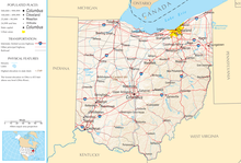
Ohio's location has proven to be an asset for economic growth and expansion. Because it links the Northeast to the Midwest, much cargo and business traffic passes through its borders along its well-developed highways. Ohio has the nation's 10th-largest highway network and is within a one-day drive of 50% of North America's population and 70% of North America's manufacturing capacity.[101] To the north, Ohio has 312 miles (502 km) of coastline with Lake Erie,[102] which allows for numerous cargo ports such as Cleveland and Toledo. Ohio's southern border is defined by the Ohio River. Ohio's neighbors are Pennsylvania to the east, Michigan to the northwest, Lake Erie to the north, Indiana to the west, Kentucky on the south, and West Virginia on the southeast. Ohio's borders were defined by metes and bounds in the Enabling Act of 1802 as follows:
Bounded on the east by the Pennsylvania line, on the south by the Ohio River, to the mouth of the Great Miami River, on the west by the line drawn due north from the mouth of the Great Miami aforesaid, and on the north by an east and west line drawn through the southerly extreme of Lake Michigan, running east after intersecting the due north line aforesaid, from the mouth of the Great Miami until it shall intersect Lake Erie or the territorial line, and thence with the same through Lake Erie to the Pennsylvania line aforesaid.

Ohio is bounded by the Ohio River, but nearly all of the river belongs to Kentucky and West Virginia. In 1980, the U.S. Supreme Court held that, based on the wording of the cessation of territory by Virginia (which at the time included what is now Kentucky and West Virginia), the boundary between Ohio and Kentucky (and, by implication, West Virginia) is the northern low-water mark of the river as it existed in 1792.[103] Ohio has only that portion of the river between the river's 1792 low-water mark and the present high-water mark. The border with Michigan has also changed, as a result of the Toledo War, to angle slightly northeast to the north shore of the mouth of the Maumee River.
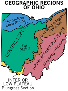
Much of Ohio features glaciated till plains, with an exceptionally flat area in the northwest being known as the Great Black Swamp. This glaciated region in the northwest and central state is bordered to the east and southeast first by a belt known as the glaciated Allegheny Plateau, and then by another belt known as the unglaciated Allegheny Plateau. Most of Ohio is of low relief, but the unglaciated Allegheny Plateau features rugged hills and forests.
Ohio's rugged southeastern quadrant, stretching in an outward bow-like arc along the Ohio River from the West Virginia Panhandle to the outskirts of Cincinnati, forms a distinct socioeconomic unit. Geologically similar to parts of West Virginia and southwestern Pennsylvania, this area's coal mining legacy, dependence on small pockets of old manufacturing establishments, and distinctive regional dialect set this section off from the rest of the state. In 1965, Congress passed the Appalachian Regional Development Act, an attempt to "address the persistent poverty and growing economic despair of the Appalachian Region".[104] It defines 29 Ohio counties as part of Appalachia.[105] While 1/3 of Ohio's land mass is part of the federally defined Appalachian region, only 12.8% of Ohioans live there (1.476 million people.)[106]
Significant Ohio rivers include the Cuyahoga River, Great Miami River, Maumee River, Muskingum River, and Scioto River. The rivers in northern Ohio drain into the northern Atlantic Ocean via Lake Erie and the St. Lawrence River, and those in southern Ohio drain into the Gulf of Mexico via the Ohio River and the Mississippi. Ohio also includes Bass Islands and Kelleys Island.[107] Grand Lake St. Marys in the west-central part of the state was constructed as a supply of water for canals in the canal-building era of 1820–1850. This body of water, over 20 square miles (52 km2), was the largest artificial lake in the world when completed in 1845.[108] Ohio's canal-building projects were not the economic fiasco that similar efforts were in other states. Some cities, such as Dayton, owe their industrial emergence to their location on canals, and as late as 1910 interior canals carried much of the bulk freight of the state.
Areas under the protection of the National Park Service include Cuyahoga Valley National Park, Hopewell Culture National Historical Park, Dayton Aviation Heritage National Historical Park, First Ladies National Historic Site, James A. Garfield National Historic Site, William Howard Taft National Historic Site, and the Charles Young Buffalo Soldiers National Monument and Perry's Victory and International Peace Memorial.[109]
Fauna

Ohio has wide variety of unique animal species. Rare and endangered species include the Eastern Hellbender, which is found in the Southeastern Appalachian region of Ohio and is classified as state endangered.[110] The Eastern Hellbender is the 3rd largest amphibian in the world, and can grow up to 27 inches in length. It is fully aquatic and breathes almost entirely through its skin. Due to this, it is only found in pristine, cool, clear, fast flowing streams and rivers. It is highly threatened by habitat loss, water pollution, and sedimentation due to logging and other human activities.[111]
Climate

The climate of Ohio is a humid continental climate (Köppen climate classification Dfa/Dfb) throughout most of the state, except in the extreme southern counties of Ohio's Bluegrass region section, which are located on the northern periphery of the humid subtropical climate (Cfa) and Upland South region of the United States. Summers are typically hot and humid throughout the state, while winters generally range from cool to cold. Precipitation in Ohio is moderate year-round. Severe weather is not uncommon in the state, although there are typically fewer tornado reports in Ohio than in states located in what is known as the Tornado Alley. Severe lake effect snowstorms are also not uncommon on the southeast shore of Lake Erie, which is located in an area designated as the Snowbelt.
Although predominantly not in a subtropical climate, some warmer-climate flora and fauna do reach well into Ohio. For instance, some trees with more southern ranges, such as the blackjack oak, Quercus marilandica, are found at their northernmost in Ohio just north of the Ohio River. Also evidencing this climatic transition from a subtropical to a continental climate, several plants such as the Southern magnolia (Magnolia grandiflora), Albizia julibrissin (mimosa), Crape Myrtle, and even the occasional Needle Palm are hardy landscape materials regularly used as street, yard, and garden plantings in the Bluegrass region of Ohio; but these same plants will simply not thrive in much of the rest of the state. This interesting change may be observed while traveling through Ohio on Interstate 75 from Cincinnati to Toledo; the observant traveler of this diverse state may even catch a glimpse of Cincinnati's common wall lizard, one of the few examples of permanent "subtropical" fauna in Ohio.
The worst weather disaster in Ohio history occurred along the Great Miami River in 1913. Known as the Great Dayton Flood, the entire Miami River watershed flooded, including the downtown business district of Dayton. As a result, the Miami Conservancy District was created as the first major floodplain engineering project in Ohio and the United States.[112]
| Location | Region | July (°F) | July (°C) | January (°F) | January (°C) |
|---|---|---|---|---|---|
| Athens | Appalachian | 85/61 | 29/16 | 40/21 | 4/−6 |
| Cincinnati | Southwest | 86/66 | 30/19 | 39/23 | 3/−5 |
| Cleveland | Northeast | 82/64 | 28/18 | 34/21 | 1/−5 |
| Columbus | Central | 85/65 | 29/18 | 36/22 | 2/−5 |
| Dayton | Miami Valley | 87/67 | 31/19 | 36/22 | 2/−5 |
| Toledo | Northwest | 84/62 | 29/17 | 32/18 | 0/−7 |
| Youngstown | Northeast | 81/60 | 27/15 | 32/19 | 0/−7 |
The highest recorded temperature was 113 °F (45 °C), near Gallipolis on July 21, 1934.[114] The lowest recorded temperature was −39 °F (−39 °C), at Milligan on February 10, 1899,[115] during the Great Blizzard of 1899.[116]
Earthquakes
Although few have registered as noticeable to the average resident, more than 200 earthquakes with a magnitude of 2.0 or higher have occurred in Ohio since 1776.[117] The Western Ohio Seismic Zone and a portion of the Southern Great Lakes Seismic Zone are located in the state, and numerous faults lie under the surface.[117][118]
The most substantial known earthquake in Ohio history was the Anna (Shelby County) earthquake,[119] which occurred on March 9, 1937. It was centered in western Ohio, with a magnitude of 5.4, and was of intensity VIII.[120]
Other significant earthquakes in Ohio include:[121] one of magnitude 4.8 near Lima on September 19, 1884;[122] one of magnitude 4.2 near Portsmouth on May 17, 1901;[123] and one of 5.0 in LeRoy Township in Lake County on January 31, 1986, which continued to trigger 13 aftershocks of magnitude 0.5 to 2.4 for two months.[124][125]
Notable Ohio earthquakes in the 21st century include one occurring on December 31, 2011, approximately 4 kilometers (2.5 mi) northwest of Youngstown,[126] and one occurring on June 10, 2019, approximately 5 kilometers (3.1 mi) north-northwest of Eastlake under Lake Erie;[127] both registered a 4.0 magnitude.
Cities
There are 13 metropolitan statistical areas in Ohio, anchored by 16 cities, as defined by the U.S. Office of Management and Budget. Additionally, 30 Ohio cities function as centers of micropolitan statistical areas, urban clusters smaller than that of metropolitan areas. Ohio's three largest cities are Columbus, Cleveland, and Cincinnati.
Columbus is the capital of the state, near its geographic center, and is well known for Ohio State University. In 2019, the city had six corporations named to the U.S. Fortune 500 list: Alliance Data, Nationwide Mutual Insurance Company, American Electric Power, L Brands, Huntington Bancshares, and Cardinal Health in suburban Dublin.[128][129] Other major employers include hospitals (among others, Wexner Medical Center and Nationwide Children's Hospital), high tech research and development including the Battelle Memorial Institute, information-based companies such as OCLC and Chemical Abstracts Service, manufacturer Worthington Industries, and financial institutions such as JPMorgan Chase and Huntington Bancshares. Fast food chains Wendy's and White Castle are also headquartered in Columbus.
Located in Northeast Ohio along the Lake Erie shore, Cleveland is characterized by its New England heritage, ethnic immigrant cultures, and history as a major American manufacturing and healthcare center. It anchors the Cleveland–Akron–Canton Combined Statistical Area, of which the industrial cities of Akron and Canton are constituent parts. Mansfield, Sandusky and Youngstown are also major cities in the region. Northeast Ohio is known for major industrial companies Goodyear Tire and Rubber and Timken, top-ranked colleges Case Western Reserve University, Oberlin College, and Kent State University, the Cleveland Clinic, and cultural attractions including the Cleveland Museum of Art, Big Five member Cleveland Orchestra, Cuyahoga Valley National Park, Playhouse Square, the Pro Football Hall of Fame, and the Rock and Roll Hall of Fame.
Cincinnati anchors Southwest Ohio and the Cincinnati metropolitan area, which also encompasses counties in Kentucky and Indiana. The metropolitan area is home to Miami University and the University of Cincinnati, Cincinnati Union Terminal, Cincinnati Symphony Orchestra, and various Fortune 500 companies, including Procter & Gamble, Kroger, Macy's, Inc., and Fifth Third Bank. Dayton and Springfield are in the Miami Valley, which is home to the University of Dayton, the Dayton Ballet, and the extensive Wright-Patterson Air Force Base.
Toledo and Lima are the major cities in Northwest Ohio, an area known for its glass-making industry. It is home to Owens Corning and Owens-Illinois, two Fortune 500 corporations.
Steubenville is the only metropolitan city in Appalachian Ohio, a region known for its mixed mesophytic forests. Other metropolitan areas that contain cities in Ohio but are primarily in other states include the Huntington, West Virginia and Wheeling, West Virginia areas. Ohio is the US state with the highest number of cities with the same name as UK cities.[130]
| Rank | Name | County | Pop. | Rank | Name | County | Pop. | ||
|---|---|---|---|---|---|---|---|---|---|
 Columbus  Cleveland |
1 | Columbus | Franklin | 905,748 | 11 | Youngstown | Mahoning | 60,068 |  Cincinnati Toledo |
| 2 | Cleveland | Cuyahoga | 372,624 | 12 | Springfield | Clark | 58,662 | ||
| 3 | Cincinnati | Hamilton | 309,317 | 13 | Kettering | Montgomery | 57,862 | ||
| 4 | Toledo | Lucas | 270,871 | 14 | Elyria | Lorain | 52,656 | ||
| 5 | Akron | Summit | 190,469 | 15 | Cuyahoga Falls | Summit | 51,114 | ||
| 6 | Dayton | Montgomery | 137,644 | 16 | Middletown | Butler | 50,987 | ||
| 7 | Parma | Cuyahoga | 81,146 | 17 | Lakewood | Cuyahoga | 50,942 | ||
| 8 | Canton | Stark | 70,872 | 18 | Newark | Licking | 49,934 | ||
| 9 | Lorain | Lorain | 65,211 | 19 | Euclid | Cuyahoga | 49,692 | ||
| 10 | Hamilton | Butler | 62,082 | 20 | Dublin | Franklin | 49,328 | ||
Demographics
| Census | Pop. | Note | %± |
|---|---|---|---|
| 1800 | 45,365 | — | |
| 1810 | 230,760 | 408.7% | |
| 1820 | 581,434 | 152.0% | |
| 1830 | 937,903 | 61.3% | |
| 1840 | 1,519,467 | 62.0% | |
| 1850 | 1,980,329 | 30.3% | |
| 1860 | 2,339,511 | 18.1% | |
| 1870 | 2,665,260 | 13.9% | |
| 1880 | 3,198,062 | 20.0% | |
| 1890 | 3,672,329 | 14.8% | |
| 1900 | 4,157,545 | 13.2% | |
| 1910 | 4,767,121 | 14.7% | |
| 1920 | 5,759,394 | 20.8% | |
| 1930 | 6,646,697 | 15.4% | |
| 1940 | 6,907,612 | 3.9% | |
| 1950 | 7,946,627 | 15.0% | |
| 1960 | 9,706,397 | 22.1% | |
| 1970 | 10,652,017 | 9.7% | |
| 1980 | 10,797,630 | 1.4% | |
| 1990 | 10,847,115 | 0.5% | |
| 2000 | 11,353,140 | 4.7% | |
| 2010 | 11,536,504 | 1.6% | |
| 2020 | 11,799,448 | 2.3% | |
| Source: 1910–2020[132] | |||
Population
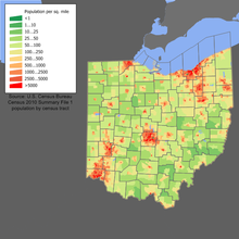
From just over 45,000 residents in 1800, Ohio's population grew faster than 10% per decade (except for the 1940 census) until the 1970 census, which recorded just over 10.65 million Ohioans.[133] Growth then slowed for the next four decades.[134] The United States Census Bureau counted 11,808,848 in the 2020 census, a 2.4% increase since the 2010 United States census.[135] Ohio's population growth lags that of the entire United States, and whites are found in a greater density than the U.S. average. As of 2000[update], Ohio's center of population is located in Morrow County,[136] in the county seat of Mount Gilead.[137] This is approximately 6,346 feet (1,934 m) south and west of Ohio's population center in 1990.[136]
Graphs are unavailable due to technical issues. There is more info on Phabricator and on MediaWiki.org. |

As of 2011, 27.6% of Ohio's children under the age of 1 belonged to minority groups.[138] Approximately 6.2% of Ohio's population was under five years of age, 23.7% under 18 years of age, and 14.1% were 65 or older; females made up an estimated 51.2% of the population.
According to HUD's 2022 Annual Homeless Assessment Report, there were an estimated 10,654 homeless people in Ohio.[139][140]
Birth data
Note: Births in table do not add up because Hispanics are counted both by their ethnicity and by their race, giving a higher overall number.
| Race | 2013[141] | 2014[142] | 2015[143] | 2016[144] | 2017[145] | 2018[146] | 2019[147] | 2020[148] | 2021[149] | 2022[150] |
|---|---|---|---|---|---|---|---|---|---|---|
| White | 109,749 (79.0%) | 110,003 (78.9%) | 109,566 (78.7%) | ... | ... | ... | ... | ... | ... | ... |
| > Non-Hispanic White | 104,059 (74.9%) | 104,102 (74.6%) | 103,586 (74.4%) | 100,225 (72.6%) | 98,762 (72.1%) | 97,423 (72.1%) | 95,621 (71.1%) | 92,033 (71.2%) | 92,761 (71.5%) | 90,671 (70.7%) |
| Black | 24,952 (18.0%) | 24,931 (17.9%) | 25,078 (18.0%) | 22,337 (16.2%) | 22,431 (16.4%) | 22,201 (16.4%) | 22,555 (16.8%) | 21,447 (16.6%) | 20,748 (16.0%) | 20,380 (15.9%) |
| Asian | 3,915 (2.8%) | 4,232 (3.0%) | 4,367 (3.1%) | 4,311 (3.1%) | 4,380 (3.2%) | 4,285 (3.2%) | 4,374 (3.3%) | 3,995 (3.1%) | 3,862 (3.0%) | 3,923 (3.1%) |
| American Indian | 320 (0.2%) | 301 (0.2%) | 253 (0.2%) | 128 (0.1%) | 177 (0.1%) | 169 (0.1%) | 204 (0.2%) | 102 (>0.1%) | 107 (>0.1%) | 204 (0.2%) |
| Hispanic (of any race) | 6,504 (4.7%) | 6,884 (4.9%) | 6,974 (5.0%) | 7,420 (5.4%) | 7,468 (5.5%) | 7,432 (5.5%) | 7,725 (5.7%) | 7,669 (5.9%) | 8,228 (6.3%) | 9,062 (7.1%) |
| Total Ohio | 138,936 (100%) | 139,467 (100%) | 139,264 (100%) | 138,085 (100%) | 136,832 (100%) | 135,134 (100%) | 134,461 (100%) | 129,191 (100%) | 129,791 (100%) | 128,231 (100%) |
- Since 2016, data for births of White Hispanic origin are not collected, but included in one Hispanic group; persons of Hispanic origin may be of any race.
Ancestry
| Race and ethnicity[151] | Alone | Total | ||
|---|---|---|---|---|
| White (non-Hispanic) | 75.9% | 79.9% | ||
| African American (non-Hispanic) | 12.3% | 14.0% | ||
| Hispanic or Latino[g] | — | 4.4% | ||
| Asian | 2.5% | 3.1% | ||
| Native American | 0.2% | 1.7% | ||
| Pacific Islander | 0.04% | 0.1% | ||
| Other | 0.4% | 1.2% | ||
| Racial and ethnic composition | 1990[152] | 2000[153] | 2010[154] | 2020[155] |
|---|---|---|---|---|
| White | 87.8% | 85.0% | 82.7% | 77.0% |
| African American | 10.6% | 11.5% | 12.2% | 12.5% |
| Asian | 0.8% | 1.2% | 1.7% | 2.5% |
| Native | 0.2% | 0.2% | 0.2% | 0.3% |
| Native Hawaiian and other Pacific Islander |
– | – | – | – |
| Other race | 0.5% | 0.8% | 1.1% | 1.9% |
| Two or more races | – | 1.4% | 2.1% | 5.8% |
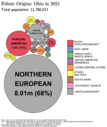
In 2010, there were 469,700 foreign-born residents in Ohio, corresponding to 4.1% of the total population. Of these, 229,049 (2.0%) were naturalized U.S. citizens and 240,699 (2.1%) were not.[12] The largest groups were:[156] Mexico (54,166), India (50,256), China (34,901), Germany (19,219), Philippines (16,410), United Kingdom (15,917), Canada (14,223), Russia (11,763), South Korea (11,307), and Ukraine (10,681). Though predominantly white, Ohio has large black populations in all major metropolitan areas throughout the state, Ohio has a significant Hispanic population made up of Mexicans in Toledo and Columbus, and Puerto Ricans in Cleveland and Columbus, and also has a significant and diverse Asian population in Columbus.
Ancestry groups (which the census defines as not including racial terms) in the state were:[12][157] 26.5% German, 14.1% Irish, 9.0% English, 6.4% Italian, 3.8% Polish, 2.5% French, 1.9% Scottish, 1.7% Hungarian, 1.6% Dutch, 1.5% Mexican, 1.2% Slovak, 1.1% Welsh, and 1.1% Scotch-Irish. Ancestries claimed by less than 1% of the population include Sub-Saharan African, Puerto Rican, Swiss, Swedish, Arab, Greek, Norwegian, Romanian, Austrian, Lithuanian, Finnish, West Indian, Portuguese and Slovene.
Languages
About 6.7% of the population age 5 years and older reported speaking a language other than English, with 2.2% of the population speaking Spanish, 2.6% speaking other Indo-European languages, 1.1% speaking Asian and Austronesian languages, and 0.8% speaking other languages.[12] Numerically: 10,100,586 spoke English, 239,229 Spanish, 55,970 German, 38,990 Chinese, 33,125 Arabic, and 32,019 French. In addition, 59,881 spoke a Slavic language and 42,673 spoke another West Germanic language according to the 2010 census.[158] Ohio also had the nation's largest population of Slovene speakers, second largest of Slovak speakers, second largest of Pennsylvania Dutch (German) speakers, and the third largest of Serbian speakers.[159]
Religion
Religious self-identification, per Public Religion Research Institute's 2021 American Values Survey[160]

According to Public Religion Research Institute's 2021 American Values Survey, 64% of Ohioans identified as Christian. Specifically, 19% of Ohio's population identified as Mainline Protestant, 17% as Evangelical Protestant, 7% as Historically Black Protestant, and 18% as Catholic. Roughly 30% of the population were unaffiliated with any religious body. Small minorities of Jews (2%), Hindus (1%), Jehovah's Witnesses (<1%), Muslims (<1%), Buddhists (<1%), Mormons (<1%), and other faiths exist according to this study.[160] Altogether, those identifying with a religion or spiritual tradition were 70% of the state's population.
Per the Association of Religion Data Archives's (ARDA) 2020 study, Christianity remained the predominant religion. Non-denominational Christianity, numbering 1,411,863, were the largest Protestant cohort, although Catholicism remained the single-largest denomination with 1,820,233 adherents.[161] According to the ARDA, in 2010 the largest Christian denominations by adherents were the Catholic Church with 1,992,567; the United Methodist Church with 496,232; the Evangelical Lutheran Church in America with 223,253, the Southern Baptist Convention with 171,000, the Christian Churches and Churches of Christ with 141,311, the United Church of Christ with 118,000, and the Presbyterian Church (USA) with 110,000.[162] With about 80,000 adherents in 2020, Ohio had the second largest Amish population of all U.S. states, only behind neighboring Pennsylvania.[163]
According to a Pew Forum poll in 2014, a majority of Ohioans, 56%, felt religion was "very important", 25% that it was "somewhat important", and 19% that religion was "not too important/not important at all". Among them, 38% of Ohioans indicate that they attend religious services at least once weekly, 32% occasionally, and 30% seldom or never.[164]
Economy

According to the U.S. Census Bureau, the total number of people employed in 2016 was 4,790,178. The total number of unique employer establishments was 252,201, while the total number of non-employer establishments was 785,833.[165] In 2010, Ohio was ranked second in the country for best business climate by Site Selection magazine, based on a business-activity database.[166] The state has also won three consecutive Governor's Cup awards from the magazine, based on business growth and developments.[167] As of 2016[update], Ohio's gross domestic product (GDP) was $626 billion.[168] This ranks Ohio's economy as the seventh-largest among all 50 states and Washington, D.C.[169]
The Small Business & Entrepreneurship Council ranked the state No. 10 for best business-friendly tax systems in their Business Tax Index 2009, including a top corporate tax and capital gains rate that were both ranked No. 6 at 1.9%.[170] Ohio was ranked No. 11 by the council for best friendly-policy states according to their Small Business Survival Index 2009.[171] The Directorship's Boardroom Guide ranked the state No. 13 overall for best business climate, including No. 7 for best litigation climate.[172] Forbes ranked the state No. 8 for best regulatory environment in 2009.[173] Ohio has five of the top 115 colleges in the nation, according to U.S. News & World Report's 2010 rankings,[174] and was ranked No. 8 by the same magazine in 2008 for best high schools.[175]
Ohio's unemployment rate stands at 4.5% as of February 2018,[176] down from 10.7% in May 2010.[177][178] The state still lacks 45,000 jobs compared to the pre-recession numbers of 2007.[179] The labor force participation as of April 2015 is 63%, slightly above the national average.[179] As of 2023[update], Ohio's per capita income was $60,402, ranking 38th in the U.S., and the state's median household income was $65,720.[180][181] Also in 2023, 13.4% of the population was living below the poverty line.[182]
The manufacturing and financial activities sectors each compose 18.3% of Ohio's GDP, making them Ohio's largest industries by percentage of GDP.[169] Ohio has the third largest manufacturing workforce behind California and Texas.[183][184] Ohio has the largest bioscience sector in the Midwest, and is a national leader in the "green" economy. Ohio is the largest producer in the country of plastics, rubber, fabricated metals, electrical equipment, and appliances.[185] 5,212,000 Ohioans are currently employed by wage or salary.[169]
By employment, Ohio's largest sector is trade/transportation/utilities, which employs 1,010,000 Ohioans, or 19.4% of Ohio's workforce, while the health care and education sector employs 825,000 Ohioans (15.8%).[169] Government employs 787,000 Ohioans (15.1%), manufacturing employs 669,000 Ohioans (12.9%), and professional and technical services employs 638,000 Ohioans (12.2%).[169] Ohio's manufacturing sector is the third-largest of all fifty United States states in terms of gross domestic product.[169] Fifty-nine of the United States' top 1,000 publicly traded companies (by revenue in 2008) are headquartered in Ohio, including Procter & Gamble, Goodyear Tire & Rubber, AK Steel, Timken, Abercrombie & Fitch, and Wendy's.[186]
Ohio is also one of 41 states with its own lottery,[187] the Ohio Lottery.[188] As of 2020[update], the Ohio Lottery has contributed more than $26 billion to education beginning in 1974.[189]
Income inequality in Ohio, both before and after taxes, has risen significantly since the 1970s.[190] Ohio's overall income grew in Ohio from 2009 to 2012, with an overall 7.1% increase in income growth. The top 1% had a 37.0% in income growth, while the bottom 99% grew their income by only 2.3%. The top 1% accounted for 71.9% of the overall shared income during this period.[191] The burden of income tax falls disproportionately on lower-income tax brackets. In 2018, the bottom 20% of earners contributed 12.3% of their income towards various taxes, while the top 1% only paid 6.5%.[192]
Transportation


Roads
Many major east–west transportation corridors go through Ohio. One of those pioneer routes, known in the early 20th century as "Main Market Route 3", was chosen in 1913 to become part of the historic Lincoln Highway which was the first road across America, connecting New York City to San Francisco. In Ohio, the Lincoln Highway linked many towns and cities together, including Canton, Mansfield, Wooster, Lima, and Van Wert. The Lincoln Highway's arrival in Ohio was a major influence on the state's development. Upon the advent of the federal numbered highway system in 1926, the Lincoln Highway through Ohio became U.S. Route 30.
Ohio is home to 228 miles (367 km) of the National Road, now U.S. Route 40.
Ohio has a highly developed network of roads and interstate highways. Major east-west through routes include the Ohio Turnpike (I-80/I-90) in the north, I-76 through Akron to Pennsylvania, I-70 through Columbus and Dayton, and the Appalachian Highway (State Route 32) running from West Virginia to Cincinnati. Major north–south routes include I-75 in the west through Toledo, Dayton, and Cincinnati, I-71 through the middle of the state from Cleveland through Columbus and Cincinnati into Kentucky, and I-77 in the eastern part of the state from Cleveland through Akron, Canton, New Philadelphia and Marietta south into West Virginia. Interstate 75 between Cincinnati and Dayton is one of Ohio's most heavily traveled sections of interstate.
Trails
Ohio has a highly developed network of signed state bicycle routes. Many of them follow rail trails, with conversion ongoing. The Ohio to Erie Trail (route 1) connects Cincinnati, Columbus, and Cleveland. U.S. Bicycle Route 50 traverses Ohio from Steubenville to the Indiana state line outside Richmond.[193]
Ohio has several long-distance hiking trails, the most prominent of which is the Buckeye Trail, which extends 1,444 mi (2,324 km) in a loop around the state. Part of it is on roads and part on wooded trail. Additionally, the North Country Trail (the longest of the 11 National Scenic Trails authorized by Congress) and the American Discovery Trail (a system of recreational trails and roads that collectively form a coast-to-coast route across the mid-tier of the United States) pass through Ohio. Much of these two trails coincide with the Buckeye Trail.
Rail
Ohio passenger rail | |||||||||||||||||||||||||||||||||||||||||||||||||||||||||||||||
|---|---|---|---|---|---|---|---|---|---|---|---|---|---|---|---|---|---|---|---|---|---|---|---|---|---|---|---|---|---|---|---|---|---|---|---|---|---|---|---|---|---|---|---|---|---|---|---|---|---|---|---|---|---|---|---|---|---|---|---|---|---|---|---|
| |||||||||||||||||||||||||||||||||||||||||||||||||||||||||||||||
Ohio has an extensive rail network, though today most lines carry only freight traffic. Three Class I freight railroads operate in Ohio: CSX Transportation, Norfolk Southern Railway, and Canadian National Railway. Many local freight carriers also exist in the state.
Amtrak, the national passenger railroad, operates three long-distance rail routes through Ohio. The Lake Shore Limited serves Cleveland, Elyria, Toledo, Sandusky, and Bryan. The Capitol Limited stops in those cities as well as in Alliance. The Cardinal serves Cincinnati Union Terminal. From Ohio, passengers can ride directly to Chicago, New York, Boston, Washington, D.C., Indianapolis, Pittsburgh, Buffalo, and dozens of destinations in-between.
Columbus is the largest city in the U.S. with no passenger rail. Its Union Station was last served in 1979 by the National Limited.
Ohio is home to several scenic railways and museums, including the Cuyahoga Valley Scenic Railroad through Cuyahoga Valley National Park, the Age of Steam Roundhouse museum, and the Hocking Valley Scenic Railway near Hocking Hills State Park.
Transit

Mass transit exists in many forms in Ohio cities, primarily through bus systems. The Greater Cleveland Regional Transit Authority (GCRTA) operates the RTA Rapid Transit system, which consists of one heavy rail line, three light rail lines, and three bus rapid transit lines. Cincinnati is served by the Southwest Ohio Regional Transit Authority (SORTA) bus network as well as a 3.6-mile (5.8 km) streetcar line, the Cincinnati Bell Connector. Other major transit agencies in Ohio include the Central Ohio Transit Authority (COTA) serving Columbus and the Greater Dayton Regional Transit Authority (GDRTA) serving Dayton.
Air travel
Ohio has four international airports, four commercial, and two military. The four international include Cleveland Hopkins International Airport, John Glenn Columbus International Airport, Dayton International Airport, and Rickenbacker International Airport (one of two military airfields). The other military airfield is Wright Patterson Air Force Base which is one of the largest Air Force bases in the United States. Other major airports are in Toledo and Akron. Cincinnati's main airport, Cincinnati/Northern Kentucky International Airport, is in Hebron, Kentucky, and therefore is not included in Ohio airport lists.
Waterways
Law and government

The state government of Ohio consists of the executive, legislative, and judicial branches.[194][195][196] The political culture of Ohio has been described as moderate.[197]
Executive branch
The executive branch is headed by the governor of Ohio.[194] The current governor is Mike DeWine since 2019, a member of the Republican Party.[198] A lieutenant governor succeeds the governor in the event of any removal from office, and performs any duties assigned by the governor.[199][200] The current lieutenant governor is Jon Husted. The other elected constitutional offices in the executive branch are the secretary of state (Frank LaRose), auditor (Keith Faber), treasurer (Robert Sprague), and attorney general (Dave Yost).[194] There are 21 state administrative departments in the executive branch.[201][202]
Legislative branch

The Ohio General Assembly is a bicameral legislature consisting of the Senate and House of Representatives.[203] The Senate is composed of 33 districts, each of which is represented by one senator. Each senator represents approximately 330,000 constituents.[204] The House of Representatives has 99 members.[205] The Republican Party is the majority party in both houses as of the 2022 election cycle.
In order to be enacted into law, a bill must be adopted by both houses of the General Assembly and signed by the governor. If the governor vetoes a bill, the General Assembly can override the veto with a three-fifths supermajority of both houses. A bill will also become a law if the governor fails to sign or veto it within 10 days of its being presented. The session laws are published in the official Law of Ohio.[206] These in turn have been codified in the Ohio Revised Code.[207]
The General Assembly, with the approval of the governor, draws the U.S. congressional district lines for Ohio's 16 seats in the United States House of Representatives. The Ohio Apportionment Board draws state legislative district lines in Ohio.
Judicial branch

There are three levels of the Ohio state judiciary. The lowest is the court of common pleas: each county maintains its own constitutionally mandated court of common pleas, which maintain jurisdiction over "all justiciable matters".[208] The intermediate-level court system is the district court system.[209] Twelve courts of appeals exist, each retaining jurisdiction over appeals from common pleas, municipal, and county courts in a set geographical area.[208] A case heard in this system is decided by a three-judge panel, and each judge is elected.[208]
The state's highest-ranking court is the Ohio Supreme Court.[210] A seven-justice panel composes the court, which, by its own discretion, hears appeals from the courts of appeals, and retains original jurisdiction over limited matters.[211]
Local government
There are also several levels of local government in Ohio: counties, municipalities (cities and villages), townships, special districts, and school districts.
Ohio is divided into 88 counties.[212] Ohio law defines a structure for county government, although they may adopt charters for home rule.[213][214] Summit County[213] and Cuyahoga County[215] have chosen an alternate form of government. The other counties have a government with a three-member board of county commissioners,[216] a sheriff,[217] coroner,[218] auditor,[219] treasurer,[220] clerk of the court of common pleas[221] prosecutor,[222] engineer,[223] and recorder.[224]
There are two kinds of incorporated municipalities, 251 cities and 681 villages.[213][225][226] If a municipality has five thousand or more residents as of the last United States Census it is a city, otherwise it is a village.[213][227] Municipalities have full home rule powers, may adopt a charter, ordinances and resolutions for self-government.[228] Each municipality chooses its own form of government, but most have elected mayors and city councils or city commissions. City governments provide much more extensive services than county governments, such as police forces and paid (as opposed to volunteer) fire departments.
The entire area of the state is encompassed by townships.[213] When the boundaries of a township are coterminous with the boundaries of a city or village, the township ceases to exist as a separate government (called a paper township).[213] Townships are governed by a three-member board of township trustees.[213] Townships may have limited home rule powers.[229]
There are more than 600 city, local, and exempted village school districts providing K-12 education in Ohio, as well as about four dozen joint vocation school districts, which are separate from the K-12 districts. Each city school district, local school district, or exempted village school district is governed by an elected board of education.[213] A school district previously under state supervision (municipal school district) may be governed by a board whose members either are elected or appointed by the mayor of the municipality containing the greatest portion of the district's area.[213]
Politics
| Party affiliation as of May 2024[230] | |||||
|---|---|---|---|---|---|
| Party | Registered voters | Percentage | |||
| Unaffiliated | 5,734,850 | 71.15% | |||
| Republican | 1,508,641 | 18.72% | |||
| Democratic | 817,063 | 10.13% | |||
| Total | 8,060,554 | 100% | |||
"Mother of presidents"
Six U.S. presidents hailed from Ohio at the time of their elections, giving rise to its nickname "mother of presidents", a sobriquet it shares with Virginia. It is also termed "modern mother of presidents", in contrast to Virginia's status as the origin of presidents earlier in American history. Seven presidents were born in Ohio, making it second to Virginia's eight. Virginia-born William Henry Harrison lived most of his life in Ohio and is also buried there. Harrison conducted his political career while living on the family compound, founded by his father-in-law, John Cleves Symmes, in North Bend, Ohio. The seven presidents born in Ohio were Ulysses S. Grant (elected from Illinois), Rutherford B. Hayes, James A. Garfield, Benjamin Harrison (grandson of William Henry Harrison & elected from Indiana), William McKinley, William Howard Taft and Warren G. Harding.[231] All seven were Republicans.
Electoral history

Ohio has been considered a swing state, being won by either the Democratic or Republican candidates reasonably each election. As such, it is usually targeted by both major-party campaigns, especially in competitive elections.[232] Pivotal in the election of 1888, Ohio has been a regular swing state since 1980 and considered a bellwether.[233][234] This status was called into question after incumbent Republican Donald Trump won the state by an eight-point margin in the 2020 presidential election despite losing nationally to Democratic challenger Joe Biden.[235]
Historian R. Douglas Hurt asserts that not since Virginia "had a state made such a mark on national political affairs".[236] The Economist notes that "This slice of the mid-west contains a bit of everything American—part north-eastern and part southern, part urban and part rural, part hardscrabble poverty and part booming suburb".[237] Since 1896, Ohio has had only three misses in the general election (Thomas E. Dewey in 1944, Richard Nixon in 1960, and Donald Trump in 2020) and had the longest perfect streak of any state, voting for the winning presidential candidate in each election from 1964 to 2016, and in 33 of the 38 held since the Civil War. No Republican has ever won the presidency without winning Ohio.
As of 2019, there are more than 7.8 million registered Ohioan voters, with 1.3 million Democrats and 1.9 million Republicans. They are disproportionate in age, with a million more over 65 than there are 18- to 24-year-olds.[238] Since the 2010 midterm elections, Ohio's voter demographic has leaned towards the Republican Party.[239] The governor, Mike DeWine, is Republican, as are all other non-judicial statewide elected officials, including Lieutenant Governor Jon A. Husted, Attorney General Dave Yost, State Auditor Keith Faber, Secretary of State Frank LaRose and State Treasurer Robert Sprague. In the Ohio State Senate the Republicans are the majority, 25–8, and in the Ohio House of Representatives the Republicans control the delegation 64–35.
Losing one seat in the U.S. House of Representatives following the 2020 census, Ohio has 15 seats for the two presidential elections of the decade in 2024 and 2028.[240] As of the 2022 cycle, ten federal representatives are Republicans while five are Democrats. Marcy Kaptur (D-09) is the most senior member of the Ohio delegation to the U.S. House of Representatives.[241] The senior U.S. senator, Sherrod Brown, is a Democrat, while the junior, JD Vance, is a Republican.[242][243]
Allegations of voter suppression
Since 1994, the state has had a policy of purging infrequent voters from its rolls. In April 2016, a lawsuit was filed, challenging this policy on the grounds that it violated the National Voter Registration Act (NVRA) of 1993[244] and the Help America Vote Act of 2002.[245] In June, the federal district court ruled for the plaintiffs and entered a preliminary injunction applicable only to the November 2016 election. The preliminary injunction was upheld in September by the Court of Appeals for the Sixth Circuit. Had it not been upheld, thousands of voters would have been purged from the rolls just a few weeks before the election.[244][246]
It was estimated in 2017 that the state has removed up to two million voters since 2011.[247][better source needed]
In a 2020 study, Ohio was ranked as the 17th hardest state for citizens to vote in.[248]
Education
Ohio's system of public education is outlined in Article VI of the state constitution, and in Title XXXIII of the Ohio Revised Code. Ohio University, the first university in the Northwest Territory, was also the first public institution in Ohio. Substantively, Ohio's system is similar to those found in other states. At the State level, the Ohio Department of Education, which is overseen by the Ohio State Board of Education, governs primary and secondary educational institutions. At the municipal level, there are approximately 700 school districts statewide. The Ohio Board of Regents coordinates and assists with Ohio's institutions of higher education which have recently been reorganized into the University System of Ohio under Governor Strickland. The system averages an annual enrollment of more than 400,000 students, making it one of the five largest state university systems in the U.S.
Colleges and universities
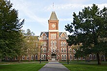
Ohio is home to several public and private institutions of higher learning. Prior to statehood, the Northwest Ordinance of 1787 included a provision to establish an institution of higher education in the region, which resulted in the establishment of Ohio University in 1804 as Ohio's first college.[250][251][252]
Ohio schools consistently ranking in the top 50 nationally of the U.S. News & World Report of liberal arts colleges include members of the “Five Colleges of Ohio”: Denison University, Kenyon College and Oberlin College. Ranking in the top 100 of national research universities typically includes Case Western Reserve University, Ohio State University and Miami University.[253]
- 13 state universities
- Bowling Green State University (Bowling Green)
- Central State University (Wilberforce)
- Cleveland State University (Cleveland)
- Kent State University (Kent)
- Miami University (Oxford)
- Ohio State University, (Columbus)
- Ohio University (Athens)
- Shawnee State University (Portsmouth)
- University of Akron (Akron)
- University of Cincinnati (Cincinnati)
- University of Toledo (Toledo)
- Wright State University (Dayton)
- Youngstown State University (Youngstown)
- 24 state university branch and regional campuses

- 46 private colleges and universities
- 6 free-standing state-assisted medical schools
- Boonshoft School of Medicine, Wright State University
- Heritage College of Osteopathic Medicine, Ohio University
- Northeast Ohio Medical University
- The Ohio State University College of Medicine and Public Health
- University of Cincinnati College of Medicine
- University of Toledo College of Medicine (formerly Medical University of Ohio)
- 15 community colleges
- 8 technical colleges
- 24 independent non-profit colleges
Libraries
Ohio is home to some of the nation's highest-ranked public libraries.[255] The 2008 study by Thomas J. Hennen Jr. ranked Ohio as number one in a state-by-state comparison.[256] For 2008, 31 of Ohio's library systems were all ranked in the top ten for American cities of their population category.[255]
- 500,000 books or more
- Columbus Metropolitan Library (First)
- Cuyahoga County Public Library (Second)
- Public Library of Cincinnati and Hamilton County (Tenth)
The Ohio Public Library Information Network (OPLIN) is an organization that provides Ohio residents with internet access to their 251 public libraries. OPLIN also provides Ohioans with free home access to high-quality, subscription research databases.
Ohio also offers the OhioLINK program, allowing Ohio's libraries (particularly those from colleges and universities) access to materials for the other libraries. The program is largely successful in allowing researchers for access to books and other media that might not be otherwise available.
Culture
Arts
Music

The Rock and Roll Hall of Fame and the Rhythm and Blues Music Hall of Fame are both located in Cleveland. Cleveland disc jockey Alan Freed is credited with coining the term and promoting rock and roll in the early 1950s. Cincinnati is home to the American Classical Music Hall of Fame and Museum. Six Ohio musicians are Rock and Roll Hall of Fame members, Dave Grohl (Nirvana and Foo Fighters), the Isley Brothers, Nine Inch Nails, Bobby Womack, Benjamin Orr (The Cars), and Chrissie Hynde (The Pretenders). Also inducted was disk jockey Alan Freed.
Other popular musicians from Ohio include Mamie Smith, Dean Martin, Tyler Joseph and Josh Dun of Twenty One Pilots, Frankie Yankovic, Doris Day, the McGuire Sisters, Howard Hewett, Shirley Murdock, Boz Scaggs, John Legend, Marilyn Manson, Starset, Dan Auerbach and Patrick Carney of the Black Keys, Griffin Layne, Joe Dolce, Kid Cudi, William "Bootsy" Collins, Stephanie Eulinberg of Kid Rock's Twisted Brown Trucker Band, and Devo.
Performing arts

Playhouse Square in downtown Cleveland is the nation's second-largest performing arts center, home to ten theaters.[257] The Cleveland Orchestra is one of the historic Big Five orchestras in the U.S. and considered among the best worldwide.[258]
Many other Ohio cities are home to their own orchestras, including Akron, Blue Ash, Canton, Cincinnati, Columbus, Dayton, Toledo, and Youngstown. Cincinnati is home to its own ballet, symphony orchestra, pops orchestra, and opera, all housed at the Cincinnati Music Hall. Dayton is also home to a ballet, orchestra, and opera, collectively known as the Dayton Performing Arts Alliance.
The Columbus Association for the Performing Arts manages seven historic Columbus area theaters.[259]
Within the marching arts, Winter Guard International has hosted national championships in performing arts at the University of Dayton 18 times between 1983 and 2003, and has permanently since 2005. The Bluecoats Drum and Bugle Corps are Ohio's highest fielding drum corps, competing in the Drum Corps International World Class circuit out of Canton.
Visual arts

Ohio is home to 30 art institutions, including the Columbus Museum of Art, Cincinnati Art Museum, Cleveland Museum of Art, and other entities. The full list includes:
- Akron Art Museum, Akron
- Allen Memorial Art Museum, Oberlin College
- Billy Ireland Cartoon Library & Museum, Ohio State University
- Burchfield Homestead, Salem
- Butler Institute of American Art, Youngstown
- Canton Museum of Art, Canton
- Cincinnati Art Museum, Cincinnati
- Cleveland Museum of Art, Cleveland
- Columbus Museum of Art, Columbus
- Contemporary Arts Center, Cincinnati
- Dayton Art Institute, Dayton
- Frank Museum of Art, Otterbein University
- National Imperial Glass Museum, Bellaire
- Kennedy Museum of Art, Ohio University
- Temple Museum of Religious Art, Case Western Reserve University
- Mansfield Art Center, Mansfield
- McDonough Museum of Art, Youngstown State University
- Miami University Art Museum, Miami University
- Museum of Ceramics, East Liverpool
- Museum of Contemporary Art Cleveland, Cleveland
- Ohio Glass Museum, Lancaster
- Richard Ross Museum of Art, Ohio Wesleyan University
- Springfield Center for the Arts at Wittenberg University, Wittenberg University
- Taft Museum of Art, Cincinnati
- Toledo Museum of Art, Toledo
- Toy and Plastic Brick Museum, Bellaire
- University of Findlay's Mazza Museum, University of Findlay
- Wexner Center for the Arts, Ohio State University
- Whitby Mansion, Sidney
The Cincinnati Art Museum holds over 100,000 works spanning 6,000 years of human history, being among the most comprehensive collections in the Midwest. Among its notable collections are works by Master of San Baudelio, Jorge Ingles, Sandro Botticelli (Judith with Head of Holofernes), Matteo di Giovanni, Domenico Tintoretto (Portrait of Venetian dux Marino Grimani), Mattia Preti, Bernardo Strozzi, Frans Hals, Bartolomé Esteban Murillo (St. Thomas of Villanueva), Peter Paul Rubens (Samson and Delilah) and Aert van der Neer. The collection also includes works by Jean-Baptiste-Camille Corot, Pierre-Auguste Renoir, Camille Pissarro, Claude Monet (Rocks At Belle Isle), and Pablo Picasso. The museum also has a large collection of paintings by American painter Frank Duveneck (Elizabeth B. Duveneck).
The Cleveland Museum of Art is internationally renowned for its substantial holdings of Asian and Egyptian art, and has a permanent collection of more than 61,000 works from around the world.[261] It is the fourth-wealthiest art museum in the United States.[262]
The Columbus Museum of Art holds nineteenth and early twentieth-century American and European art, including early Cubist paintings by Pablo Picasso and Juan Gris, works by François Boucher, Paul Cézanne, Mary Cassatt, Jean Auguste Dominique Ingres, Edgar Degas, Henri Matisse, Claude Monet, Edward Hopper, and Norman Rockwell, and installations by Mel Chin, Josiah McElheny, Susan Philipsz, and Allan Sekula. Also in Columbus, the Billy Ireland Cartoon Library & Museum collection includes 450,000 original cartoons, 36,000 books, 51,000 serial titles, and 3,000 feet (910 m) of manuscript materials, plus 2.5 million comic strip clippings and tear sheets, making it the largest research library for cartoon art.
Youngstown's Butler Institute of American Art was the first museum dedicated exclusively to American art.[263]
Sports
Professional sports teams

Огайо является домом для восьми профессиональных спортивных команд пяти различных высших лиг США. В число нынешних команд входят « Цинциннати Редс» и «Кливленд Гардианс» из Высшей лиги бейсбола . [264][ 265 ] Коламбус Крю СК и ФК Цинциннати из Высшей футбольной лиги , [ 266 ] « Кливленд Кавальерс» Национальной баскетбольной ассоциации , [ 267 ] « Цинциннати Бенгалс» и «Кливленд Браунс» Национальной футбольной лиги , [ 268 ] и «Коламбус Блю Джекетс» Национальной хоккейной лиги . [ 269 ]
Огайо привез домой семь титулов Мировой серии («Красные» 1919, 1940, 1975, 1976, 1990; Индианс 1920, 1948), три Кубка MLS (Crew 2008 , 2020 , 2023 ), один чемпионат НБА («Кавальерс», 2016) и девять чемпионатов НФЛ. ( Профи 1920 ; Бульдоги 1922 , 1923 , 1924 ; Рэмс 1945 ; Брауны 1950 , 1954 , 1955 , 1964 ). Несмотря на этот успех в НФЛ в первой половине 20-го века, ни одна команда Огайо не выиграла Суперкубок с момента его создания в 1967 году . Ни одна команда Огайо не участвовала в финале Кубка Стэнли .

Огайо сыграл центральную роль в развитии Высшей бейсбольной лиги и Национальной футбольной лиги. Первая полностью профессиональная бейсбольная команда «Цинциннати Ред чулки» 1869 года была организована в Огайо. [ 270 ] Неформальная ассоциация американского футбола начала 20-го века, Лига Огайо , была прямым предшественником современной НФЛ, хотя ни одна из современных франшиз НФЛ Огайо не ведет своих корней от клуба Лиги Огайо. Сама НФЛ была основана в Кантоне в 1920 году как Конференция американского профессионального футбола. [ 72 ] Первая официальная игра состоялась 3 октября 1920 года, когда « Дейтонские треугольники» обыграли « Коламбус Панхандлс» со счетом 14–0 в Дейтоне. [ 73 ] В 1963 году Кантон был провозглашен домом Зала славы профессионального футбола . [ 74 ]
В меньшем масштабе Огайо принимает бейсбол низшей лиги , футбол на арене , мини-футбол , хоккей среднего уровня и футбол низшего дивизиона.
Индивидуальные виды спорта
Поле спортивных автомобилей Мид-Огайо принимало несколько чемпионатов по автогонкам, в том числе CART World Series , IndyCar Series , NASCAR Nationwide Series , Can-Am , Formula 5000 , чемпионат IMSA GT , американскую серию Ле-Мана и серию спортивных автомобилей Rolex . Гран -при Кливленда также принимал гонки CART с 1982 по 2007 год. Спидвей Эльдора - это крупный грязный овал, на котором проводятся гонки NASCAR Camping World Truck Series , World of Outlaws Sprint Cars и USAC Silver Crown Series гонки .
В Огайо проводятся два PGA Tour мероприятия : WGC-Bridgestone Invitational и Мемориальный турнир . Cincinnati Masters — теннисный турнир ATP World Tour Masters 1000 и WTA Premier 5 .
Колледж спорта

В Огайо есть восемь NCAA Division I Football Bowl Subdivision футбольных команд колледжей , разделенных на три разные конференции . Он также добился значительных успехов на средних и высших уровнях футбольных подразделений колледжей.
есть две программы На конференциях Power Five ; « Огайо Стейт Баккейз» из конференции «Большой десятки» и « Цинциннати Беаркэтс» из конференции «Большой 12» . Футбольная команда штата Огайо Баккейз занимает второе место по проценту побед за всю историю с общим рекордом 931–327–53 и рекордом 25–26 мячей по состоянию на 2020 год . Благодаря этой программе семь победителей Heisman Trophy , сорок титулов на конференциях и восемь бесспорных национальных чемпионатов. Мужская баскетбольная программа участвовала в мужском баскетбольном турнире первого дивизиона NCAA 27 раз.
одержала Мужская баскетбольная команда Cincinnati Bearcats более 1800 побед и 33 матча в March Madness , а футбольная команда Bearcats стала первой командой так называемой «группы пяти», вышедшей в плей-офф студенческого футбола в 2022 году. [ 271 ]
В конференциях Группы пяти на Среднеамериканской конференции представлены шесть команд : Akron Zips , Bowling Green Falcons , Kent State Golden Flashes , Miami RedHawks , Ohio Bobcats и Toledo Rockets . Штаб-квартира MAC находится в Кливленде. Матч соперничества Цинциннати и Майами проводится на юго-западе Огайо каждый год с 1888 года и является старейшим нынешним футбольным соперничеством NCAA вне конференции.
Другие школы Дивизиона I, либо входящие в Подразделение чемпионата по футболу Дивизиона I NCAA , либо не участвующие в футболе, включают Cleveland State Vikings , Xavier Musketeers , Wright State Raiders и Youngstown State Penguins . Ксавьера Мужской баскетбол показал себя особенно хорошо: он выступил на турнире 27 March Madness . штата Янгстаун Футбол занимает третье место по количеству побед в чемпионате NCAA Division I по футболу - 3.
В Огайо 12 университетов NCAA Division II и 22 университета NCAA Division III .
См. также
Примечания
- ^ Согласно переписи населения США, [ 7 ] Большой Колумбус - крупнейший статистический район мегаполиса (MSA), полностью расположенный на территории Огайо, с населением 2 078 725 человек; и Большой Цинциннати - крупнейший MSA, который, по крайней мере частично, находится на территории Огайо, с населением 2 179 082 человека, примерно 25% из которых проживает в Индиане или Кентукки. Какой MSA является крупнейшим в Огайо, зависит от контекста.
- ^ Перейти обратно: а б Высота приведена к североамериканской вертикальной системе отсчета 1988 года .
- ^ Петун , Эри , Чоннонтон , Виандот , Минго Сенека и Конфедерация ирокезов
- ^ Майами , Маскутен Ленапе Шони и Одава
- ^ Мосопелеа
- ↑ Последний французский форт в стране Огайо, Форт Сандаски, был разрушен в 1763 году во время восстания Понтиака.
- ^ Лица латиноамериканского или латиноамериканского происхождения не различают полное и частичное происхождение.
Ссылки
- ^ «Девиз штата Огайо» . Историческое общество Огайо. 1 июля 2005 года. Архивировано из оригинала 6 октября 2007 года . Проверено 27 марта 2009 г.
- ^ Перейти обратно: а б с д и ж г час я дж к «Символы штата Огайо» . Резиденция губернатора Огайо и Государственный сад. Архивировано из оригинала 23 апреля 2009 года . Проверено 26 марта 2009 г.
- ^ Перейти обратно: а б Мэри Стоквелл (2006). Приключения в Огайо . Гиббс Смит. п. 88. ИСБН 978-1-4236-2382-3 . Архивировано из оригинала 31 марта 2015 года . Проверено 16 июня 2015 г.
- ^ «Принятие Огайо в качестве штата» . Палата представителей США. Архивировано из оригинала 10 ноября 2019 года . Проверено 10 ноября 2019 г.
- ^ «Краткая информация об Огайо» . Историческое общество Огайо. Архивировано из оригинала 8 февраля 2009 года . Проверено 26 марта 2009 г.
- ^ «Город Колумбус: интересные факты» . Город Колумбус, штат Огайо. 2006. Архивировано из оригинала 1 мая 2009 года . Проверено 26 марта 2009 г.
- ^ Годовая оценка за июль 2017 г. Архивировано 27 декабря 1996 г. в Wayback Machine.
- ^ Перейти обратно: а б «Высоты и расстояния в США» . Геологическая служба США . 2001. Архивировано из оригинала 22 июля 2012 года . Проверено 24 октября 2011 г.
- ^ «Годовая оценка численности постоянного населения округов: с 1 апреля 2020 г. по 1 июля 2023 г.» . Бюро переписи населения США . Проверено 24 марта 2024 г.
- ^ «Средний годовой доход семьи» . Фонд семьи Генри Дж. Кайзера . Архивировано из оригинала 20 декабря 2016 года . Проверено 9 декабря 2016 г.
- ^ Перейти обратно: а б «Почему Огайо известен как штат Бакай и почему жители Огайо известны как Бакай?» (PDF) . Ноябрь 1998 г. Архивировано (PDF) из оригинала 12 апреля 2019 г. Проверено 7 декабря 2018 г.
- ^ Перейти обратно: а б с д «Американский FactFinder — Результаты» . factfinder2.census.gov . Бюро переписи населения США. Архивировано из оригинала 12 февраля 2020 года . Проверено 17 октября 2012 г.
- ^ «Официальные сокращения USPS» . Почтовая служба США. 1998. Архивировано из оригинала 28 марта 2009 года . Проверено 26 марта 2009 г.
- ^ «Огайо» . Словарь Merriam-Webster.com . Проверено 8 марта 2024 г.
- ^ «Краткие факты о штате Огайо» . Центр истории Огайо. Архивировано из оригинала 27 ноября 2010 года . Проверено 2 июля 2010 г.
От ирокезского слова, означающего «великая река».
- ^ «Родной Огайо» . Исследования американских индейцев . Университет штата Огайо . Архивировано из оригинала 2 февраля 2007 года . Проверено 25 февраля 2007 г.
Огайо происходит от сенека (ирокезского) ohiiyo 'хорошая река'.
- ^ Уильям М. Дэвидсон (1902). История Соединенных Штатов . Скотт, Форесман и компания. п. 265 . Проверено 16 июня 2015 г.
- ^ «Валовой внутренний продукт (ВВП) США по штатам, 2019 г.» . Статистика . Архивировано из оригинала 20 ноября 2018 года . Проверено 28 декабря 2020 г.
- ^ Жирарди-Шахтер, Тейлор (3 сентября 2019 г.). «10 лучших штатов по производству в 2019 году» . Журнал глобальной торговли . Архивировано из оригинала 3 декабря 2020 года . Проверено 31 декабря 2019 г.
- ^ Берг-Андерссон, Ричард Э. (2000). «Математика распределения представителей в ходе переписи 2000 года» . Зеленые книги . Архивировано из оригинала 6 января 2009 года . Проверено 25 марта 2009 г.
- ^ «Президенты штата Огайо - государственный секретарь штата Огайо» . Ohiosos.gov . Архивировано из оригинала 21 января 2021 года . Проверено 28 декабря 2020 г.
- ^ Перейти обратно: а б Кнеппер (1989), стр. 9.
- ^ Перейти обратно: а б Кнеппер (1989), стр. 10.
- ^ Кнеппер (1989), стр. 11.
- ^ Дуглас Т. Прайс; Гэри М. Фейнман (2008). Образы прошлого, 5-е издание. Нью-Йорк: МакГроу-Хилл. стр. 274–277.
- ^ Перейти обратно: а б с Кнеппер (1989), стр. 13.
- ^ "Культура Мононгахела - 1050–1635 гг. н. э." . Археология Форт-Хилла. Проверено 14 января 2010 г.
- ^ Кнеппер (1989), стр. 14.
- ^ Роузбум (1967), с. 20.
- ^ Луи, Франклин, Жан Батист. «Карта Луизианы Франклена». LOC.gov. Проверено 17 августа 2017 г.
- ^ Неппер (1989), стр. 14–17.
- ^ Неппер (1989), стр. 43–44.
- ^ «Американские индейцы - Центр истории Огайо» . сайт ohiohistorycentral.org . Архивировано из оригинала 29 декабря 2020 года . Проверено 23 февраля 2021 г.
- ^ «Войны и сражения: Парижский мирный договор (1763 г.)» . www.us-history.com. Архивировано из оригинала 4 декабря 2015 года . Проверено 9 марта 2022 г.
- ^ Биллингтон, Рэй А. (1944). «Договор Форт-Стэнвикс 1768 года». История Нью-Йорка . 25 (2). Издательство Университета Небраски: 182–194. JSTOR 23147791 .
- ^ Сосин, Джек М. (1961). Уайтхолл и дикая местность: Средний Запад в британской колониальной политике, 1760–1775 гг . Издательство Корнельского университета. п. 146. Архивировано из оригинала 18 января 2020 года . Проверено 9 марта 2022 г.
- ^ Уайт, Ричард (1991). Золотая середина: индейцы, империи и республики в районе Великих озер, 1650–1815 гг . Издательство Кембриджского университета. п. 256. ИСБН 0-521-42460-7 .
- ^ Джеральд Э. Харт (1891). Квебекский акт 1774 года . Монреаль: Типография Gazette. п. 12 .
- ^ Гордон Вуд, Американская революция (Нью-Йорк: Random House , 2002).
- ^ Даунс, Пожары Совета , 211; Нестер, «Пограничная война» , 194; Нельсон, выдающийся человек , 101.
- ^ Даунс, Пожары Совета , 266.
- ^ Келлер, Кристина; Бойд, Коллин; Грувер, Марк; Хилл, Марк (2011). «Археология битв при восстановлении форта, округ Мерсер, штат Огайо: образование и защита» (PDF) . Американская программа защиты полей боя Службы национальных парков. п. 61. Архивировано (PDF) из оригинала 12 июня 2019 года . Получено 24 ноября 2019 г. - через Государственный университет Болла.
- ^ Веслагер, индейцы Делавэра , 316.
- ^ Стернер, Эрик (6 февраля 2018 г.). «Моравцы в центре: резня в Гнаденхуттене» . Журнал американской революции . Архивировано из оригинала 30 сентября 2019 года . Проверено 30 сентября 2019 г.
- ^ Коглиано, Фрэнсис Д. (2003). Революционная Америка, 1763–1815: Политическая история . Фрэнсис и Тейлор. ISBN 978-1-134-67869-3 . Архивировано из оригинала 20 февраля 2021 года . Проверено 19 ноября 2020 г.
- ^ Каплан, Лоуренс С. (сентябрь 1983 г.). «Парижский договор 1783 года: историографический вызов». Международный исторический обзор . 5 (3). Тейлор и Фрэнсис, ООО: 431–442. дои : 10.1080/07075332.1983.9640322 . ISSN 0707-5332 . JSTOR 40105317 .
- ^ Кейтон (2002), с. 3.
- ^ «Религия и Конгресс Конфедерации, 1774–89» . Библиотека Конгресса. 4 июня 1998 года. Архивировано из оригинала 2 мая 2012 года . Проверено 11 апреля 2012 г.
- ^ Хаббард, Роберт Эрнест. Генерал Руфус Патнэм: главный военный инженер Джорджа Вашингтона и «отец Огайо», стр. 1–4, McFarland & Company, Inc., Джефферсон, Северная Каролина. ISBN 978-1-4766-7862-7 .
- ^ Хаббард, Роберт Эрнест. Генерал Руфус Патнэм: главный военный инженер Джорджа Вашингтона и «отец Огайо», стр. 2–4, 45–8,105–18, McFarland & Company, Inc., Джефферсон, Северная Каролина. ISBN 978-1-4766-7862-7 .
- ^ Хилдрет, Сэмюэл Прескотт. Биографические и исторические мемуары первых поселенцев-пионеров Огайо, стр. 34–7, 63–74, Badgley Publishing Company, 2011. ISBN 978-0-615-50189-5 .
- ^ Маккалоу, Дэвид. Пионеры: героическая история поселенцев, принесших американский идеальный Запад, стр. 46–7, Simon & Schuster, Inc., Нью-Йорк, Нью-Йорк, 2019. ISBN 978-1-5011-6870-3 .
- ^ Хаббард, Роберт Эрнест. Генерал Руфус Патнэм: главный военный инженер Джорджа Вашингтона и «отец Огайо», стр. 127–50, McFarland & Company, Inc., Джефферсон, Северная Каролина. ISBN 978-1-4766-7862-7 .
- ^ Хилдрет, Сэмюэл Прескотт. Биографические и исторические мемуары первых поселенцев-пионеров Огайо, стр. 69, 71, 81, 82, Badgley Publishing Company, 2011. ISBN 978-0-615-50189-5 .
- ^ Маккалоу, Дэвид. Пионеры: героическая история поселенцев, принесших американский идеальный Запад, стр. 143–7, Simon & Schuster, Inc., Нью-Йорк, Нью-Йорк, 2019. ISBN 978-1-5011-6870-3 .
- ^ Закон, обеспечивающий надлежащее исполнение законов Соединенных Штатов в штате Огайо, гл. 7, 2 Стат. 201 (19 февраля 1803 г.).
- ^ Перейти обратно: а б Блю, Фредерик Дж. (осень 2002 г.). «Дата обретения статуса штата Огайо» . Информационный бюллетень Академии истории Огайо . Архивировано из оригинала 11 сентября 2010 года.
- ^ Совместная резолюция о приеме штата Огайо в Союз ( Pub. L. 83–204 , 67 Stat. 407 , принята 7 августа 1953 г. ).
- ^ «Разъяснение путаницы вокруг принятия штата Огайо» . Архивировано из оригинала 17 октября 2009 года . Проверено 30 октября 2009 г.
- ^ «Племя шауни и война 1812 года» . Архивировано из оригинала 25 февраля 2022 года . Проверено 25 февраля 2022 г.
- ^ Стоквелл, Мэри (2014). Другой след слез: изгнание индейцев Огайо .
- ^ «Что случилось с индейцами, когда-то населявшими Огайо? - Колонки Джима Блаунта» . Архивировано из оригинала 25 февраля 2022 года . Проверено 25 февраля 2022 г.
- ^ Неппер (1989), стр. 233–234.
- ^ Роузбум и Вайзенбургер (1967), с. 188.
- ^ «Рейд Моргана — Центр истории Огайо» . Ohiohistorycentral.org . Архивировано из оригинала 21 июня 2018 года . Проверено 2 апреля 2018 г.
- ^ Кейтон (2002), с. 129.
- ^ Кейтон (2002), стр. 128–129.
- ^ Перейти обратно: а б с «История сталелитейного производства Огайо» . OhioSteel.org . Архивировано из оригинала 25 июля 2010 года . Проверено 17 августа 2017 г.
- ^ «Флаг штата Огайо (1901 г.)» . Центр истории Огайо. Архивировано из оригинала 21 февраля 2022 года . Проверено 21 февраля 2022 г.
- ^ «Братья Райт — первый успешный самолет» . Национальный музей авиации и космонавтики. Архивировано из оригинала 21 февраля 2022 года . Проверено 21 февраля 2022 г.
- ^ «Наводнение 1913 года в штате Огайо» . Центр истории Огайо. Архивировано из оригинала 21 февраля 2022 года . Проверено 21 февраля 2022 г.
- ^ Перейти обратно: а б «Подробности временной шкалы | Официальный сайт Зала славы профессионального футбола» . Архивировано из оригинала 15 сентября 2018 года . Проверено 14 сентября 2018 г.
- ^ Перейти обратно: а б «Треугольный парк: место первой игры НФЛ» . Архивировано из оригинала 21 февраля 2022 года . Проверено 21 февраля 2022 г.
- ^ Перейти обратно: а б Марун, Томас; Марун, Маргарет; Холберт, Крейг (2006). Футбольное наследие Акрон-Кантона . Издательство Аркадия. ISBN 978-0-7385-4078-8 . Архивировано из оригинала 7 января 2022 года . Проверено 5 января 2022 г.
- ^ Перейти обратно: а б «Великая депрессия» . Центр истории Огайо. Архивировано из оригинала 21 февраля 2022 года . Проверено 21 февраля 2022 г.
- ^ Биттверк, Рэндалл. «СС и Супермен» . Calvin.edu . Архивировано из оригинала 26 июня 2015 года . Проверено 17 августа 2017 г.
- ^ «Религия Супермена (Кларк Кент/Кал-Эл)» . Adherents.com . Архивировано из оригинала 21 мая 2009 года . Проверено 17 августа 2017 г.
- ^ «Наводнение 1913 года в штате Огайо» . Вторая мировая война. Архивировано из оригинала 21 февраля 2022 года . Проверено 21 февраля 2022 г.
- ^ «Карл Б. Стоукс» . Центр истории Огайо. Архивировано из оригинала 21 февраля 2022 года . Проверено 21 февраля 2022 г.
- ^ Хильдебранд, Херрингтон и Келлер; стр. 165–166
- ^ Перейти обратно: а б с д и Лэмптон, Дэвид М. (2024). Живые отношения США и Китая: от холодной войны к холодной войне . Лэнхэм, доктор медицины: Роуман и Литтлфилд . ISBN 978-1-5381-8725-8 .
- ^ Перейти обратно: а б Арден, Скотт; ДеКарло, Кристофер (ноябрь 2021 г.). «Изучение занятости в промышленности Среднего Запада с 1990 по 2019 год» . www.bls.gov . Бюро статистики труда . Архивировано из оригинала 21 февраля 2023 года . Проверено 21 февраля 2023 г.
- ^ «Историческая таблица членства в профсоюзах Огайо: Информационное бюро Среднего Запада» . www.bls.gov . Бюро статистики труда . Архивировано из оригинала 21 февраля 2023 года . Проверено 21 февраля 2023 г.
- ^ Вуди, Тодд (23 ноября 2009 г.). «Солнечная энергетика приносит луч надежды в Ржавый пояс» . Архивировано из оригинала 17 апреля 2017 года . Проверено 17 августа 2017 г. - через LA Times.
- ^ «Третий рубеж Огайо – история» . Огайо.gov . Архивировано из оригинала 6 октября 2010 года . Проверено 17 августа 2017 г.
- ^ Перейти обратно: а б «Третья граница Огайо продолжает создавать рабочие места и возможности для жителей Огайо» . PRNewswire (Пресс-релиз). Коалиция развития бизнеса штата Огайо. Архивировано из оригинала 18 августа 2017 года . Проверено 17 августа 2017 г.
- ^ Перейти обратно: а б «Атлантический глаз: Бруннер — лучший для Огайо». Архивировано 5 августа 2010 года в Wayback Machine , Марк С. Элленбоген. 3 мая 2010 г. Проверено 5 мая 2010 г.
- ^ « Пять городов, которые поднимутся в условиях новой экономики», Christian Science Monitor . Проверено 27 ноября 2009 г.» . Христианский научный монитор . 20 ноября 2009 года. Архивировано из оригинала 23 ноября 2009 года . Проверено 14 февраля 2021 г.
- ^ «Правительство Огайо объявляет северо-запад Огайо центром солнечной энергии» . ABCLocal.go.com . 30 июня 2010 года. Архивировано из оригинала 6 июля 2010 года . Проверено 17 августа 2017 г.
- ^ Перейти обратно: а б Бюро статистики труда США (1 января 1976 г.). «Уровень безработицы в Огайо» . ФРЕД, Федеральный резервный банк Сент-Луиса . Архивировано из оригинала 21 февраля 2023 года . Проверено 21 февраля 2023 г.
- ^ «Огайо пережил десятилетие потери рабочих мест» . Dispatch.com . 12 сентября 2010 года. Архивировано из оригинала 5 октября 2010 года . Проверено 17 августа 2017 г.
- ^ Гжегорек, Винс (20 мая 2010 г.). «Мы номер один: Кайахога лидирует по потерям права выкупа в Огайо... снова» . CleveScene.com . Архивировано из оригинала 18 августа 2017 года . Проверено 17 августа 2017 г.
- ^ «Бедность в Огайо, рост незастрахованных ставок; средний доход резко падает» . Кливленд.com . Сентябрь 2010. Архивировано из оригинала 18 августа 2017 года . Проверено 17 августа 2017 г.
- ^ Перейти обратно: а б Факты об Огайо, 2016 год: экономика Огайо занимает 7-е место среди штатов. Архивировано 31 января 2017 года в Wayback Machine , Комиссия законодательной службы штата Огайо.
- ^ Перейти обратно: а б Фэйи, Кевин (2 сентября 2021 г.). «Что случилось?: Выборы 2020 года подтвердили, что Огайо больше не является колеблющимся штатом» . blogs.lse.ac.uk . Архивировано из оригинала 21 февраля 2023 года . Проверено 21 февраля 2023 г.
- ^ ЛеБлан, Поль; Диас, Даниэлла (4 декабря 2022 г.). «Сенатор Шеррод Браун говорит, что Огайо все еще находится в колеблющемся штате перед выборами 2024 года | CNN Politics» . CNN . Архивировано из оригинала 21 февраля 2023 года . Проверено 21 февраля 2023 г.
- ^ Гангитано, Алекс (9 сентября 2022 г.). «Огайо снова демонстрирует признаки того, что демократы снова становятся колеблющимся штатом» . Холм . Архивировано из оригинала 21 февраля 2023 года . Проверено 21 февраля 2023 г.
- ^ Перейти обратно: а б «Карта коронавируса в Огайо и количество случаев» . Нью-Йорк Таймс . 1 апреля 2020 г. ISSN 0362-4331 . Архивировано из оригинала 22 февраля 2023 года . Проверено 22 февраля 2023 г.
- ^ "Коронавирус (COVID-19)" . www.coronavirus.ohio.gov . Департамент здравоохранения штата Огайо . Архивировано из оригинала 22 февраля 2023 года . Проверено 22 февраля 2023 г.
- ^ Эллерброк, Мэтью; Демко, Ирина; Лендель, Ирина; Хенрихсен, Эрика (1 марта 2021 г.). «Экономическое воздействие пандемии COVID-19 на Огайо» . Все публикации Школы городских дел Максин Гудман Левин : 1–7. Архивировано из оригинала 5 апреля 2023 года . Проверено 22 февраля 2023 г.
- ^ «Транспорт доставляет в Огайо» . Огайо: Министерство транспорта. 12 февраля 2003. Архивировано из оригинала 24 января 2008 года . Проверено 22 декабря 2005 г.
- ^ «Прибрежные округа Огайо» . Огайо: Департамент природных ресурсов. Архивировано из оригинала 30 августа 2008 года . Проверено 3 сентября 2008 г.
- ^ «Огайо против Кентукки, 444 США 335» . Найдите закон. 21 января 1980 года. Архивировано из оригинала 28 августа 2014 года . Проверено 15 августа 2016 г.
- ^ «История Аппалачской региональной комиссии» . Аппалачская региональная комиссия . Архивировано из оригинала 22 декабря 2005 года . Проверено 3 января 2006 г.
- ^ «Округов в Аппалачах». Архивировано 17 сентября 2008 года в Wayback Machine , Аппалачская региональная комиссия. Проверено 3 января 2006 г.
- ^ «GCT-T1 Оценки численности населения округа Огайо — 2005» , Бюро переписи населения США, получено 3 января 2006 г. Истинное суммирование населения округов Аппалачей Огайо (1 476 384 человека), полученное путем сложения населения 29 отдельных округов вместе (1 июля 2005 г., данные). Процент, полученный путем деления этого числа на оценку населения Огайо по данным таблицы по состоянию на 1 июля 2005 г. (11 464 042).
- ^ Закон Гвиллима (20 мая 2015 г.). Административное деление стран: всеобъемлющий мировой справочник, 1900–1998 гг . МакФарланд. п. 396. ИСБН 978-1-4766-0447-3 . Проверено 26 октября 2023 г.
- ^ «История» . Сент-Мэрис развивается . Архивировано из оригинала 2 марта 2021 года . Проверено 24 февраля 2021 г.
- ^ «Огайо» . Служба национальных парков . Проверено 24 июля 2024 г.
- ^ «ВОСТОЧНЫЙ ПОВЕДИТЕЛЬ АДА» . Департамент природных ресурсов штата Огайо . Архивировано из оригинала 21 марта 2023 года . Проверено 30 ноября 2023 г.
- ^ МСОП (15 июля 2021 г.). Cryptobranchus alleganiensis: Группа специалистов МСОП SSC по амфибиям: Красный список находящихся под угрозой исчезновения видов МСОП 2022: e.T59077A82473431 (Отчет). Международный союз охраны природы. doi : 10.2305/iucn.uk.2022-2.rlts.t59077a82473431.en . Архивировано из оригинала 20 января 2024 года . Проверено 30 ноября 2023 г.
- ^ «История MCD: Закон об охране природы» . Район охраны природы Майами. Архивировано из оригинала 14 марта 2007 года . Проверено 13 января 2007 г.
- ^ «Средние климатические показатели Огайо» . Метеорологическая база. Архивировано из оригинала 9 октября 2015 года . Проверено 12 ноября 2015 г.
- ^ «Максимальные значения температуры за все время по штатам (2003 г.)» (PDF) . Национальный центр климатических данных . Архивировано из оригинала 3 марта 2013 года . Проверено 7 ноября 2006 г.
- ^ «Абсолютные минимумы температуры по штатам (2003 г.)» (PDF) . Национальный центр климатических данных . Архивировано (PDF) из оригинала 22 сентября 2008 г. Проверено 7 ноября 2006 г.
- ^ Маклеод, Джейме (6 февраля 2012 г.). «Великая метель 1899 года: Глубокий Юг, Глубокий Заморозок» . Крестьянский альманах . Архивировано из оригинала 6 февраля 2016 года . Проверено 5 февраля 2016 г.
- ^ Перейти обратно: а б Хансен, Майкл К. (2015). «Землетрясения в Огайо» (PDF) . Департамент природных ресурсов штата Огайо , Отдел геологических исследований. Архивировано (PDF) из оригинала 24 декабря 2018 г. Проверено 13 июня 2019 г.
- ^ Бараноски, Марк Т. (2013). «Карта структурных контуров на поверхности несогласия докембрия в Огайо и связанные с ней особенности фундамента» (PDF) . Департамент природных ресурсов штата Огайо, Отдел геологических исследований. Архивировано (PDF) из оригинала 3 февраля 2017 г. Проверено 13 июня 2019 г.
- ^ «Часто задаваемые вопросы о землетрясении OhioSeis: какое землетрясение было самым сильным в Огайо?» . Департамент природных ресурсов штата Огайо, Отдел геологических исследований. Архивировано из оригинала 10 апреля 2019 года . Проверено 13 июня 2019 г.
- ^ Исторические землетрясения: Западный Огайо. Архивировано 13 декабря 2007 года в Wayback Machine , Геологическая служба США.
- ^ «Исторические землетрясения в США. Огайо» . США : Геологическая служба. Архивировано из оригинала 7 октября 2009 года.
- ^ «Исторические землетрясения. Около Лимы, штат Огайо, 19 сентября 1884 г.» . США: Геологическая служба. Архивировано из оригинала 9 сентября 2009 года.
- ^ «Исторические землетрясения. Недалеко от Портсмута, штат Огайо, 31 января 1986 г.» . США: Геологическая служба. Архивировано из оригинала 9 сентября 2009 года.
- ^ «Исторические землетрясения. Северо-восточный Огайо, 31 января 1986 г.» . США: Геологическая служба. Архивировано из оригинала 9 сентября 2009 года.
- ^ «Землетрясение на северо-востоке Огайо, январь 1986 года» . Департамент природных ресурсов штата Огайо , Отдел геологических исследований. Архивировано из оригинала 29 апреля 2019 года . Проверено 13 июня 2019 г.
- ^ «Магнита 4,0 — городской район Янгстаун-Уоррен, штат Огайо» . США: Геологическая служба. Архивировано из оригинала 7 января 2012 года . Проверено 31 декабря 2011 г.
- ^ «M 4,0–5 км к северо-северо-западу от Истлейка, штат Огайо» . США: Геологическая служба. Архивировано из оригинала 11 июня 2019 года . Проверено 13 июня 2019 г.
- ^ «100 крупнейших мегаполисов США» (PDF) . Конференция мэров США. Архивировано из оригинала (PDF) 25 июня 2010 года . Проверено 22 апреля 2010 г.
- ^ Вомак, Брайан (10 июня 2019 г.). «Plano потеряет штаб-квартиру из списка Fortune 500, поскольку Alliance Data Systems переедет в Огайо» . Далласский деловой журнал . Архивировано из оригинала 25 ноября 2020 года . Проверено 19 августа 2021 г.
- ^ «Карта городов Великобритании, имеющих одинаковые названия с городами США» . Архивировано из оригинала 21 августа 2023 года . Проверено 21 августа 2023 г.
- ^ «Краткая информация о Бюро переписи населения США» . Архивировано из оригинала 2 февраля 2022 года . Проверено 3 февраля 2022 г.
- ^ «Исторические данные об изменении численности населения (1910–2020 гг.)» . Census.gov . Бюро переписи населения США. Архивировано из оригинала 29 апреля 2021 года . Проверено 1 мая 2021 г.
- ^ «Перепись населения: 1970 г., часть 37 — Огайо, раздел 1» (PDF) . Бюро переписи населения США . 1970. Архивировано (PDF) из оригинала 15 апреля 2010 года . Проверено 27 марта 2009 г.
- ^ Балистрери, Келли (февраль 2001 г.). «Новости народонаселения Огайо: Почему Огайо потерял место в Палате представителей США?» (PDF) . Центр семейных и демографических исследований при Государственном университете Боулинг-Грин . Архивировано из оригинала (PDF) 16 мая 2008 г. Проверено 27 марта 2009 г.
- ^ «Распределение населения и количество представителей по штатам: перепись 2020 года» (PDF) . Бюро переписи населения США. 26 апреля 2021 г. Архивировано (PDF) из оригинала 26 апреля 2021 г. . Проверено 26 апреля 2021 г.
- ^ Перейти обратно: а б «Население и географические центры Огайо, 2000 г.» (PDF) . Департамент развития штата Огайо, Управление стратегических исследований. Март 2001 г. Архивировано из оригинала (PDF) 24 ноября 2005 г. . Проверено 26 марта 2009 г.
- ^ «Население и населенные пункты по штатам: 2000 г.» . Бюро переписи населения США. Архивировано из оригинала 8 мая 2013 года . Проверено 6 декабря 2008 г.
- ^ « Американцы в возрасте до 1 года сейчас в основном принадлежат к меньшинствам, но не в Огайо: статистический снимок, заархивированный 14 июля 2016 года в Wayback Machine » . Обычный дилер . 3 июня 2012 г.
- ^ «Подсчет подоходного налога в 2007–2022 годах по штатам» . Архивировано из оригинала 14 марта 2023 года . Проверено 13 марта 2023 г.
- ^ «Часть 1: оценки бездомности на определенный момент времени» (PDF) . Ежегодный отчет об оценке бездомности (AHAR) за 2022 год, представленный Конгрессу . ПОЛЬЗОВАТЕЛЬ HUD. Декабрь 2022 г. Архивировано (PDF) из оригинала 15 ноября 2023 г.
- ^ Гамильтон, Бельгия; Мартин, Дж.А.; Остерман, MJK; Кертин, Южная Каролина; Мэтьюз, Ти Джей (15 января 2015 г.). «Национальные отчеты о статистике естественного движения населения» (PDF) . Центры по контролю и профилактике заболеваний . Том 64, номер 1. Архивировано (PDF) из оригинала 11 сентября 2017 года . Проверено 10 июня 2017 г.
- ^ Гамильтон, Бельгия; Мартин, Дж.А.; Остерман, MJK; Кертин, Южная Каролина; Мэтьюз, Ти Джей (23 декабря 2015 г.). «Национальные отчеты о статистике естественного движения населения» (PDF) . Центры по контролю и профилактике заболеваний . Том 64, номер 12. Архивировано (PDF) из оригинала 14 февраля 2017 года . Проверено 10 июня 2017 г.
- ^ Гамильтон, Бельгия; Мартин, Дж.А.; Остерман, MJK; Дрисколл, АК; Мэтьюз, Ти Джей (5 января 2017 г.). «Национальные отчеты о статистике естественного движения населения» (PDF) . Центры по контролю и профилактике заболеваний . Том 66, номер 1. Архивировано (PDF) из оригинала 31 августа 2017 года . Проверено 10 июня 2017 г.
- ^ Гамильтон, Бельгия; Мартин, Дж.А.; Остерман, MJK; Дрисколл, АК; Дрейк, П. (31 января 2018 г.). «Национальные отчеты о статистике естественного движения населения» (PDF) . Центры по контролю и профилактике заболеваний . Том 67, номер 1. Архивировано (PDF) из оригинала 3 июня 2018 года . Проверено 7 мая 2018 г.
- ^ Гамильтон, Бельгия; Мартин, Дж.А.; Остерман, MJK; Дрисколл, АК; Дрейк, П. (7 ноября 2018 г.). «Национальные отчеты о статистике естественного движения населения» (PDF) . Центры по контролю и профилактике заболеваний . Том 67, номер 8. Архивировано (PDF) из оригинала 1 февраля 2019 года . Проверено 21 февраля 2019 г.
- ^ Гамильтон, Бельгия; Мартин, Дж.А.; Остерман, MJK; Дрисколл, АК (27 ноября 2019 г.). «Национальные отчеты о статистике естественного движения населения» (PDF) . Центры по контролю и профилактике заболеваний . Том 68, номер 13. Архивировано (PDF) из оригинала 28 ноября 2019 года . Проверено 21 декабря 2019 г.
- ^ Гамильтон, Бельгия; Мартин, Дж.А.; Остерман, MJK; Дрисколл, АК (23 марта 2021 г.). «Национальные отчеты о статистике естественного движения населения» (PDF) . Центры по контролю и профилактике заболеваний . Том 70, номер 2. Архивировано (PDF) из оригинала 24 марта 2021 года . Проверено 1 апреля 2021 г.
- ^ Гамильтон, Бельгия; Мартин, Дж.А.; Остерман, MJK; Дрисколл, АК; Валенсуэла, Коннектикут (7 февраля 2022 г.). «Национальные отчеты о статистике естественного движения населения» (PDF) . Центры по контролю и профилактике заболеваний . Том 70, номер 17. Архивировано (PDF) из оригинала 10 февраля 2022 года . Проверено 20 февраля 2022 г.
- ^ Гамильтон, Бельгия; Мартин, Дж.А.; Остерман, MJK; Дрисколл, АК; Валенсуэла, Коннектикут (31 января 2023 г.). «Национальные отчеты о статистике естественного движения населения» (PDF) . Центры по контролю и профилактике заболеваний . Том 72, номер 1. Архивировано (PDF) оригинала 1 февраля 2023 года . Проверено 3 февраля 2022 г.
- ^ «Данные» (PDF) . www.cdc.gov . Архивировано (PDF) из оригинала 4 апреля 2024 г. Проверено 5 апреля 2024 г.
- ^ «Раса и этническая принадлежность в Соединенных Штатах: перепись 2010 года и перепись 2020 года» . Бюро переписи населения США. 12 августа 2021 года. Архивировано из оригинала 15 августа 2021 года . Проверено 26 сентября 2021 г.
- ^ Гибсон, Кэмпбелл; Юнг, Кей (сентябрь 2002 г.). «Историческая статистика переписи населения по расам, с 1790 по 1990 год и по латиноамериканскому происхождению, с 1970 по 1990 год, для Соединенных Штатов, регионов, подразделений и штатов» . Бюро переписи населения США . Архивировано из оригинала 25 июля 2008 года.
- ^ «Население Огайо: интерактивная карта переписи 2010 и 2000 годов, демография, статистика, краткие факты» . Censusviewer.com . Проверено 17 апреля 2021 г. [ постоянная мертвая ссылка ]
- ^ «Перепись Бюро переписи населения США 2010 года» . Census.gov . Архивировано из оригинала 22 мая 2017 года . Проверено 6 декабря 2017 г.
- ^ «Профиль общих характеристик населения и жилья: данные демографического профиля за 2020 год (DP-1): Огайо» . Бюро переписи населения США. Архивировано из оригинала 16 апреля 2024 года . Проверено 16 апреля 2024 г.
- ^ «Американский FactFinder — Результаты» . factfinder2.census.gov . Архивировано из оригинала 12 февраля 2020 года . Проверено 6 сентября 2013 г.
- ^ «Американский FactFinder — Результаты» . factfinder2.census.gov . Архивировано из оригинала 18 января 2015 года . Проверено 28 марта 2013 г.
- ^ «Американский FactFinder — Результаты» . factfinder2.census.gov . Бюро переписи населения США. Архивировано из оригинала 12 февраля 2020 года . Проверено 20 марта 2013 г.
- ^ «Список языков центра обработки данных» . Архивировано из оригинала 30 сентября 2015 года . Проверено 2 декабря 2019 г.
- ^ Перейти обратно: а б Персонал (24 февраля 2023 г.). «Атлас американских ценностей: религиозные традиции в Огайо» . Институт исследования общественной религии . Архивировано из оригинала 4 апреля 2017 года . Проверено 3 апреля 2023 г.
- ^ «Карты и файлы данных за 2020 год | Религиозная перепись США | Религиозная статистика и демография» . www.usreligioncensus.org . Архивировано из оригинала 15 января 2023 года . Проверено 15 апреля 2023 г.
- ^ «Ассоциация архивов религиозных данных | Отчет о государственном членстве» . www.thearda.com. Архивировано из оригинала 17 декабря 2013 года . Проверено 16 декабря 2013 г.
- ^ «Профиль населения амишей, 2020» . Элизабеттаунский колледж, Молодой центр исследований анабаптистов и пиетистов . 18 августа 2019 года. Архивировано из оригинала 11 января 2021 года . Проверено 5 февраля 2021 г.
- ^ «Религиозное ландшафтное исследование» . 11 мая 2015 года. Архивировано из оригинала 17 марта 2018 года . Проверено 16 марта 2018 г.
- ^ «Краткая информация Бюро переписи населения США: Огайо» . Архивировано из оригинала 11 ноября 2019 года . Проверено 11 ноября 2019 г.
- ^ «Рейтинги выбора сайтов» . Консультанты Грейхилл. Архивировано из оригинала 6 ноября 2011 года . Проверено 17 октября 2011 г.
- ^ «Палата Колумбуса объявляет, что Огайо включен в список «10 лучших бизнес-климатов» за 2009 год». Архивировано 8 сентября 2012 года, в Wayback Machine , Earth Times. Проверено 19 ноября 2009 г.
- ^ «Бюро экономического анализа» . Bea.gov . Министерство торговли США, BEA, Бюро экономического анализа. Архивировано из оригинала 31 августа 2017 года . Проверено 10 марта 2018 г.
- ^ Перейти обратно: а б с д и ж «Экономический обзор» (PDF) . Департамент развития штата Огайо. Февраль 2009 г. Архивировано из оригинала (PDF) 26 марта 2009 г. . Проверено 31 марта 2009 г.
- ^ «Индекс налога на бизнес за 2009 год». Архивировано 19 апреля 2009 года в Wayback Machine , СОВЕТ МАЛОГО БИЗНЕСА И ПРЕДПРИНИМАТЕЛЬСТВА. Проверено 2 декабря 2009 г.
- ^ «ИНДЕКС ВЫЖИВАНИЯ МАЛОГО БИЗНЕСА 2009». Архивировано 28 декабря 2009 г., в Wayback Machine , СОВЕТ МАЛОГО БИЗНЕСА И ПРЕДПРИНИМАТЕЛЬСТВА. Проверено 2 декабря 2009 г.
- ^ «Лучшие штаты для бизнеса» . Архивировано 10 июля 2011 года в Wayback Machine , директорство. Проверено 2 декабря 2009 г.
- ^ «Лучшие штаты для бизнеса». Архивировано 10 мая 2018 г. в Wayback Machine , Forbes. Проверено 2 декабря 2009 г.
- ^ «Лучшие колледжи 2010 года». Архивировано 2 декабря 2009 года в Wayback Machine , US News & World Report. Проверено 2 декабря 2009 г.
- ^ «Лучшие средние школы: статистика штата». Архивировано 30 апреля 2009 г., в Wayback Machine , US News & World Report. Проверено 2 декабря 2009 г.
- ^ Уровень безработицы в Огайо в феврале составил 4,5%; штат получил 13 400 рабочих мест. Архивировано 24 марта 2018 г., в Wayback Machine. Проверено 24 марта 2018 г.
- ↑ Bls.gov. Архивировано 25 июля 2018 г. в Wayback Machine ; Статистика безработицы в местных районах
- ^ «Уровень безработицы снова падает на юго-востоке Огайо». Архивировано 1 ноября 2013 года в Wayback Machine , Zanesville Times-Recorder. 23 июня 2010 г. Проверено 25 июня 2010 г.
- ^ Перейти обратно: а б Оливера Перкинс (22 мая 2015 г.) Уровень безработицы в Огайо достигает 5,2 процента: 5 вещей, которые вам нужно знать. Архивировано 25 мая 2015 г. на сайте Wayback Machine Cleveland.com.
- ^ Счет, Экономический (29 марта 2024 г.). «Личный доход по государству» . Бюро экономического анализа США (BEA) . Архивировано из оригинала 20 мая 2024 года . Проверено 24 мая 2024 г.
- ^ Бюро переписи населения США. «S1901: Доход за последние 12 месяцев» . Изучите данные переписи населения . Архивировано из оригинала 20 мая 2024 года . Проверено 24 мая 2024 г.
- ^ Уровень бедности в Огайо. Архивировано 8 июня 2021 года в Wayback Machine Statista.
- ^ Производство высокооплачиваемой продукции в Огайо. Архивировано 24 марта 2018 г., на Wayback Machine, доступ 24 марта 2018 г.
- ^ Огайо остается в тройке лучших штатов по занятости и заработной плате в обрабатывающей промышленности. Архивировано 25 марта 2018 г., на Wayback Machine, получено 24 марта 2018 г.
- ^ «Экономический обзор». Архивировано 26 марта 2009 г., в Wayback Machine , Департамент развития штата Огайо, стр. 1. Проверено 19 ноября 2009 г.
- ^ «Форчун 500 2008» . . 5 мая 2008 года. Архивировано из оригинала 26 февраля 2009 года . Проверено 31 марта 2009 г.
- ^ «Результаты лотереи» . Управление по обслуживанию граждан и коммуникациям, Управление общих служб . Архивировано из оригинала (SHTML) 27 ноября 2011 года . Проверено 31 марта 2009 г.
- ^ «О лотерее Огайо» . Комиссия по лотерее Огайо. 2008. Архивировано из оригинала 31 марта 2009 года . Проверено 31 марта 2009 г.
- ^ Опубликовано имя победителя местной лотереи Серклвилля. Архивировано 8 июня 2021 года в Wayback Machine The Scioto Press. 25 сентября 2020 г.
- ^ «Распределение доходов домохозяйств и федеральных налогов, 2011 г.» . Бюджетное управление Конгресса . 12 ноября 2014 года. Архивировано из оригинала 25 февраля 2020 года . Проверено 10 декабря 2015 г.
- ^ «Все большее неравенство в Штатах Америки: неравенство доходов по штатам, 1917–2012 годы» . Институт экономической политики . Архивировано из оригинала 5 декабря 2023 года . Проверено 12 ноября 2015 г.
- ^ Шладен, Марти (18 апреля 2023 г.). «Экономисты: фиксированный налог в Огайо усугубит неравенство» . Журнал «Огайо Кэпитал Джорнал» . Архивировано из оригинала 8 января 2024 года . Проверено 10 сентября 2023 г.
- ^ Витале, Марти (29 мая 2014 г.). «Отчет в SCOH» . Луисвилл, Кентукки: Специальный комитет по нумерации маршрутов США, Американская ассоциация государственных чиновников шоссейных дорог и транспорта . Архивировано из оригинала (Office Open XML) 31 мая 2014 года . Проверено 1 июня 2014 г.
- ^ Перейти обратно: а б с «Конституция онлайн» . Генеральная Ассамблея штата Огайо. Архивировано из оригинала 4 марта 2016 года . Проверено 25 марта 2009 г.
- ^ «Конституция онлайн» . Генеральная Ассамблея штата Огайо. Архивировано из оригинала 4 марта 2016 года . Проверено 25 марта 2009 г.
- ^ «Конституция онлайн» . Генеральная Ассамблея штата Огайо. Архивировано из оригинала 4 апреля 2016 года . Проверено 25 марта 2009 г.
- ^ Майер, Джейн (6 августа 2022 г.). «Законодательные собрания штатов поджигают демократию» . Житель Нью-Йорка . ISSN 0028-792X . Архивировано из оригинала 30 декабря 2023 года . Проверено 30 декабря 2023 г.
- ^ «Губернаторы Огайо» . Историческое общество Огайо. 8 января 2007 года. Архивировано из оригинала 5 июня 2011 года . Проверено 25 марта 2009 г.
- ^ «Конституция онлайн» . Генеральная Ассамблея штата Огайо. Архивировано из оригинала 1 октября 2018 года . Проверено 25 марта 2009 г.
- ^ «Конституция онлайн» . Генеральная Ассамблея штата Огайо. Архивировано из оригинала 4 марта 2016 года . Проверено 25 марта 2009 г.
- ^ Гарган, Джон Дж. (1994). «Исполнительная власть Огайо» . В Шарки, Мэри Энн (ред.). Политика Огайо . Издательство Кентского государственного университета . стр. 263–264. ISBN 0-87338-509-8 . LCCN 94-7637 . Архивировано из оригинала 16 февраля 2021 года . Проверено 10 февраля 2021 г.
- ^ Пересмотренный кодекс штата Огайо, § 121.01 и последующие. Пересмотренный Кодекс штата Огайо § 5703.01 и последующие. Пересмотренный Кодекс штата Огайо § 3301.13.
- ^ «Генеральная ассамблея Огайо» . Центр истории Огайо. 1 июля 2005 года. Архивировано из оригинала 28 августа 2008 года . Проверено 25 марта 2009 г.
- ^ «Население, представленное законодателями штата — Ballotpedia» . Архивировано из оригинала 18 марта 2017 года . Проверено 6 марта 2017 г.
- ^ "Правительство" . Конгрессмен Майкл Тернер. Архивировано из оригинала 25 марта 2009 года . Проверено 25 марта 2009 г.
- ^ Патнэм и Шефген 1997 , стр. 31–32.
- ^ Патнэм и Шефген 1997 , стр. 65–66.
- ^ Перейти обратно: а б с «Конституция онлайн» . Генеральная Ассамблея штата Огайо. Архивировано из оригинала 4 марта 2016 года . Проверено 25 марта 2009 г.
- ^ «Окружные апелляционные суды Огайо» . Судебная система Огайо. Архивировано из оригинала 14 мая 2009 года . Проверено 25 марта 2009 г.
- ^ «Юрисдикция и полномочия Верховного суда штата Огайо» . Судебная система Огайо. Архивировано из оригинала 14 марта 2009 года . Проверено 25 марта 2009 г.
- ^ «Конституция онлайн» . Генеральная Ассамблея штата Огайо. 2009. Архивировано из оригинала 4 апреля 2016 года . Проверено 25 марта 2009 г.
- ^ Описания отдельных штатов: 2007 г. (PDF) , Правительственная перепись 2007 г., Бюро переписи населения США , ноябрь 2012 г., стр. 235, заархивировано (PDF) из оригинала 23 ноября 2015 г. , получено 27 февраля 2022 г.
- ^ Перейти обратно: а б с д и ж г час я Перепись 2007 года , с. 235.
- ^ Патнэм и Шефген 1997 , стр. 106–114 .
- ^ «Устав» (PDF) . Council.cuyahogacounty.us . 2018. Архивировано (PDF) из оригинала 19 января 2019 года . Проверено 17 июля 2019 г.
- ^ Пересмотренный Кодекс штата Огайо § 305.01 и последующие.
- ^ Пересмотренный Кодекс штата Огайо § 311.01
- ^ Пересмотренный Кодекс Огайо § 313.01
- ^ Пересмотренный кодекс штата Огайо § 319.01
- ^ Пересмотренный кодекс штата Огайо § 321.01
- ^ Пересмотренный Кодекс Огайо § 2303.01
- ^ Пересмотренный кодекс штата Огайо § 309.01
- ^ Пересмотренный Кодекс Огайо § 315.01
- ^ Пересмотренный кодекс штата Огайо § 317.01
- ^ Государственный секретарь штата Огайо. Реестр муниципального, городского и школьного совета штата Огайо . Архивировано из оригинала 19 июля 2017 года . Проверено 27 февраля 2022 г.
- ^ «Американский FactFinder — Результаты» . factfinder.census.gov . Бюро переписи населения США. Архивировано из оригинала 3 декабря 2017 года . Проверено 17 июля 2019 г.
- ^ «Пересмотренный раздел Кодекса штата Огайо 703.01(A)» . Архивировано из оригинала 18 июля 2011 года . Проверено 12 сентября 2007 г.
- ^ Патнэм и Шефген 1997 , стр. 106–114.
- ^ Патнэм и Шефген 1997 , стр. 110–111.
- ^ «Госсекретарь предоставляет обновленную информацию о партийной принадлежности» . Архивировано из оригинала 15 мая 2024 года . Проверено 15 мая 2022 г.
- ^ Энн Генрихс (1 января 2003 г.). Огайо . Замковый камень. п. 42. ИСБН 978-0-7565-0316-1 . Архивировано из оригинала 6 сентября 2015 года . Проверено 16 июня 2015 г.
- ^ «Шансы на разделение голосов между коллегией выборщиков и населением возрастают» . ПятьТридцатьВосемь . 1 ноября 2016 года. Архивировано из оригинала 21 декабря 2016 года . Проверено 6 ноября 2016 г.
- ↑ Троллинг кампусов в поисках голосов в колеблющихся штатах. Архивировано 28 мая 2015 г., в Wayback Machine , Джули Саламон, « Нью-Йорк Таймс », 2 октября 2004 г.
- ↑ «Теория игр для свингеров» . Архивировано 1 февраля 2011 г., в Wayback Machine , Джордан Элленберг, « Slate.com », 25 октября 2004 г.
- ^ «Огайо сделал другой поворот» - Почему Огайо больше не кажется колеблющимся штатом. Архивировано 24 июля 2022 года в Wayback Machine . Новости NBC , 12 ноября 2020 г.
- ^ Холли (1999), с. 162.
- ^ «Песчинка для ваших мыслей». Архивировано 26 февраля 2006 года в Wayback Machine , The Economist , 20 декабря 2005 года. Проверено 23 декабря 2005 года.
- ^ «Еженедельная статистика избирателей в Огайо — 4 мая 2019 г.» . Проект избирателей Огайо . 5 мая 2019 года. Архивировано из оригинала 6 мая 2019 года . Проверено 5 мая 2019 г.
- ^ «Избиратели Огайо, скорее всего, будут старыми, белыми, без высшего образования и не связанными с политической партией» . Клевесцена. Архивировано из оригинала 6 мая 2019 года . Проверено 6 мая 2019 г.
- ^ Рискинд, Джонатан (24 декабря 2008 г.). «Огайо, вероятно, потеряет два места в Конгрессе в 2012 году» . Отправка Колумбуса . Архивировано из оригинала 10 мая 2011 года . Проверено 29 марта 2009 г.
- ^ «Представитель Марси Каптур (демократ от штата Огайо) призывает домовладельцев оставаться в домах, лишенных права выкупа» . Демократия сейчас. 3 февраля 2009 года. Архивировано из оригинала 11 февраля 2009 года . Проверено 29 марта 2009 г.
- ^ «Огайо — Результаты выборов 2010 года — The New York Times» . Архивировано из оригинала 28 февраля 2015 года . Проверено 24 декабря 2014 г.
- ^ «Сенаторы 111-го Конгресса» . Сенат США . Архивировано из оригинала 25 марта 2009 года . Проверено 29 марта 2009 г.
- ^ Перейти обратно: а б Дженнифер Сафстром (13 сентября 2017 г.). «Право решать, когда голосовать: Хустед против Института Филипа Рэндольфа» . АКЛУ . Архивировано из оригинала 28 апреля 2021 года . Проверено 28 мая 2021 г.
- ^ Форд, Мэтт (30 мая 2017 г.). «Использовать или потерять?» . Атлантика . Архивировано из оригинала 29 июня 2019 года . Проверено 15 мая 2019 г.
- ^ Глюк, Кэти (9 ноября 2022 г.). «Вэнс избран сенатором от Огайо; когда-то он был противником Трампа, но получил выгоду от его поддержки» . Нью-Йорк Таймс . ISSN 0362-4331 . Архивировано из оригинала 2 января 2023 года . Проверено 3 января 2023 г.
- ^ Клинтон, Хиллари Родэм, Что произошло (Нью-Йорк: Simon & Schuster, 2017), стр. 419
- ^ Дж. Поманте II, Майкл; Ли, Цюань (15 декабря 2020 г.). «Стоимость голосования в американских штатах: 2020» . Журнал избирательного права: правила, политика и политика . 19 (4): 503–509. дои : 10.1089/elj.2020.0666 . S2CID 225139517 .
- ^ По состоянию на осень 2021 г. «Предварительная численность персонала на осенний семестр 2021 г.» . Департамент высшего образования штата Огайо . Проверено 20 февраля 2022 г.
- ^ См . «Земли колледжей : диплом Университета Огайо» и Постановление о земле от 1785 года , а также Сборник законов, договоров, резолюций и постановлений: общего правительства и правительства штата, которые касаются земель в штате Огайо; в том числе законы, принимаемые губернатором и судьями; законы законодательного органа территории; и законы этого штата до 1815–1816 годов . Г. Наши, государственная типография. 1825. с. 17 .
- ^ «Земли Огайо: Краткая история» . Архивировано из оригинала 20 мая 2011 года . Проверено 27 марта 2011 г.
- ^ Джон Килборн (1907). «Общественные земли Огайо». В Генри Хоу (ред.). Исторические коллекции Огайо ... Государственная энциклопедия . Том. 1 (изд. Столетия Огайо). Штат Огайо. п. 226. Акт от 18 февраля 1804 г., т. 2, ЛО р. 193, Акт об учреждении университета в городе Афинах .
- ^ «Лучшие колледжи Огайо 2019 года | Рейтинг новостей США» . Архивировано из оригинала 24 февраля 2019 года . Проверено 24 февраля 2019 г.
- ^ Фаустин Чилдресс Джонс-Уилсон; Чарльз А. Эсбери; Д. Камили Андерсон; Сильвия М. Джейкобс; Марго Окадзава-Рей (1996). Энциклопедия афроамериканского образования . Издательская группа Гринвуд. стр. 339–. ISBN 978-0-313-28931-6 . Архивировано из оригинала 17 декабря 2019 года . Проверено 3 мая 2018 г.
- ^ Перейти обратно: а б «Рейтинги американских публичных библиотек Томаса Дж. Хеннена за 2006 год» (PDF) . Архивировано из оригинала (PDF) 28 октября 2008 г.
- ^ «Средние баллы по штату» . Архивировано из оригинала 29 октября 2008 года.
- ^ «О Театральной площади» . Архивировано из оригинала 14 мая 2016 года . Проверено 4 октября 2020 г.
- ^ «Величайшие оркестры мира» . Gramophone.co.uk . Архивировано из оригинала 24 февраля 2013 года . Проверено 17 апреля 2021 г.
- ^ «CAPA будет управлять театром Толедо» . Бизнес прежде всего в Колумбусе . 22 июня 2009 г. Архивировано из оригинала 23 ноября 2020 г. . Проверено 4 октября 2020 г.
- ^ Литт, Стивен (15 января 2019 г.). «Музей искусств Кливленда достиг рекордной посещаемости в 2018 году благодаря Кусаме, FRONT и новым программам» . Кливленд.com . Архивировано из оригинала 16 января 2019 года.
- ^ «Общая информация о музее» . Архивировано из оригинала 16 октября 2013 года . Проверено 23 марта 2015 г.
- ^ Стивен Литт (26 марта 2014 г.). «После триумфа и травм Художественный музей Кливленда ищет преданного и долгосрочного лидерства: CMA 2014» . Архивировано из оригинала 4 ноября 2016 года . Проверено 4 ноября 2016 г.
- ^ «Институт искусств получил большую часть поместья Дж. Дж. Батлера за 1 500 000 долларов» . Янгстаун Дейли Виндикатор . 29 декабря 1927 года.
- ^ «Официальный сайт Цинциннати Редс» . Высшая лига бейсбола . Архивировано из оригинала 4 апреля 2008 года . Проверено 28 марта 2009 г.
- ^ «Официальный сайт Cleveland Guardians» . Высшая лига бейсбола. Архивировано из оригинала 15 марта 2009 года . Проверено 28 марта 2009 г.
- ^ «Футбольные команды Высшей лиги» . Высшая лига футбола. Архивировано из оригинала 21 февраля 2009 года . Проверено 28 марта 2009 г.
- ^ «Индекс команд NBA.com» . Национальная баскетбольная ассоциация. Архивировано из оригинала 18 марта 2009 года . Проверено 28 марта 2009 г.
- ^ «Команды НФЛ» . Национальная футбольная лига . Архивировано из оригинала 23 февраля 2011 года . Проверено 28 марта 2009 г.
- ^ «Команды НХЛ» . Национальная хоккейная лига . Архивировано из оригинала 11 марта 2009 года . Проверено 28 марта 2009 г.
- ^ Гриффит, Грант (2007). «Легенда о красных чулках Цинциннати» . Винтажный бейсбольный клуб Цинциннати. Архивировано из оригинала 24 июля 2008 года . Проверено 28 марта 2009 г.
- ^ Блиндер, Алан (5 декабря 2021 г.). «Алабама, Мичиган, Джорджия и Цинциннати выходят в плей-офф студенческого футбола» . Нью-Йорк Таймс . Архивировано из оригинала 5 декабря 2021 года . Проверено 5 декабря 2021 г.
Библиография
- Профили Огайо: история, статистика, демография всех 1339 населенных пунктов Огайо, с подробной историей штата и правительства, а также сравнительная статистика и рейтинги. (6-е изд. Gray House Publishing, 2021 г.). 828 стр. ISBN 1-64265-827-8 ; охватывает 88 уездов, 248 городов и 689 деревень.
- Кейтон, Эндрю Р.Л. (2002). Огайо: История народа . Колумбус, Огайо: Издательство Университета штата Огайо. ISBN 0-8142-0899-1
- Керн, Кевин Ф. и Грегори С. Уилсон. (2013) Огайо: История штата Бакай (Wiley-Blackwell, 2013), 544 стр.
- Неппер, Джордж В. (1989). Огайо и его жители . Кент, Огайо: Издательство Кентского государственного университета. ISBN 978-0-87338-791-0
- Холли, Мелвин Г. (1999). Американский мэр . Государственный колледж, Пенсильвания: Издательство Пенсильванского государственного университета . ISBN 0-271-01876-3
- Роузбум, Юджин Х.; Вайзенбургер, Фрэнсис П. (1967). История Огайо . Колумбус: Историческое общество Огайо .
- Патнэм, Мелани К; Шефген, Сьюзан М (1997). Руководство по юридическим исследованиям штата Огайо . Уильяма С. Хейна и компании ISBN 978-1-57588-087-7 .
- Шмидлин, Томас; Шмидлин, Жанна Аппельханс (1996). Гром в Хартленде: хроника выдающихся погодных явлений в Огайо. Архивировано 5 апреля 2023 года в Wayback Machine . Издательство Кентского государственного университета. Кент, Огайо. ISBN 978-0-87338-549-7 .
Внешние ссылки
 Определения из Викисловаря
  СМИ из Commons
  Новости из Викиновостей
  Цитаты из Wikiquote
  Тексты из Wikisource
  Учебники из Wikibooks
  Ресурсы из Викиверситета
  Туристическая информация от Wikivoyage
- Официальный сайт штата Огайо. Архивировано 3 мая 2024 года в Wayback Machine.
- Факты о штате Огайо из Министерства сельского хозяйства США. Архивировано 24 августа 2016 г. в Wayback Machine.
- Бюро переписи населения США (краткая информация о Огайо)
- Геологическая служба США в режиме реального времени, географические и другие научные ресурсы Огайо
- Огайо в Керли
 Географические данные, относящиеся к Огайо, на OpenStreetMap.