San Francisco

San Francisco | |
|---|---|
| Город и округ Сан-Франциско | |
Мост Золотые Ворота и горизонт Сан-Франциско, вид со стороны мыса Марин | |
| Прозвища: | |
| Девиз(ы): | |
| Гимн: Официальная песня: Тема из Сан-Франциско («Открой свои Золотые Ворота»). Официальная баллада: « Я оставил свое сердце в Сан-Франциско ». [2] [3] | |
 Интерактивная карта Сан-Франциско | |
 San Francisco Расположение в Калифорнии | |
| Координаты: 37 ° 46'39 "N 122 ° 24'59" W / 37,77750 ° N 122,41639 ° W | |
| Страна | Соединенные Штаты |
| Состояние | Калифорния |
| Графство | San Francisco |
| Метро | Сан-Франциско – Окленд – Хейворд |
| CSA | Сент-Джозеф – Сент-Фрэнсис – Окленд. |
| Миссия | 29 июня 1776 г. [4] |
| Инкорпорейтед | 16 декабря 1848 г. [5] |
| Основан | Хуан Баутиста де Анса Хосе Хоакин Морага Франсиско Палоу |
| Назван в честь | Святой Франциск Ассизский |
| Правительство | |
| • Тип | Сильный мэр-совет |
| • Тело | Наблюдательный совет |
| • Мэр | Лондонская порода ( Д ) [6] |
| • Руководители [10] | Список |
| • Члены Ассамблеи [11] [12] | Мэтт Хейни ( з ) Фил Тинг ( З ) |
| • Сенатор штата | Скотт Винер ( З ) [7] |
| • Представители США | Нэнси Пелоси ( З ) [8] Кевин Маллин ( З ) [9] |
| Область | |
| • Город и округ | 231,89 квадратных миль (600,59 км 2) 2 ) |
| • Land | 46.9 sq mi (121.48 km2) |
| • Water | 184.99 sq mi (479.11 km2) 80.00% |
| • Metro | 3,524.4 sq mi (9,128 km2) |
| Elevation | 52 ft (16 m) |
| Highest elevation | 934 ft (285 m) |
| Lowest elevation [15] (Pacific Ocean) | 0 ft (0 m) |
| Population | |
| • City and county | 873,965 |
| • Estimate (2022)[16] | 808,437 |
| • Rank | 39th in North America 17th in the United States 4th in California |
| • Density | 18,634.65/sq mi (7,194.88/km2) |
| • Urban | 3,515,933 (US: 14th) |
| • Urban density | 6,843.0/sq mi (2,642.1/km2) |
| • Metro | 4,566,961 (US: 13th) |
| • CSA | 9,225,160 (US: 5th) |
| Demonym | San Franciscan[20] |
| GDP | |
| • City and county | $252.2 billion (2022) |
| • Metro | $729.1 billion (2022) |
| • CSA | $1.318 trillion (2022) |
| Time zone | UTC–08:00 (PST) |
| • Summer (DST) | UTC–07:00 (PDT) |
| ZIP Codes[22] | List |
| Area codes | 415/628[23] |
| FIPS code | 06-67000 |
| GNIS feature IDs | 277593, 2411786 |
| Website | sf.gov |
| |


San Francisco , [24] официально город и округ Сан-Франциско — коммерческий, финансовый и культурный центр Северной Калифорнии . С населением 808 437 жителей по состоянию на 2022 год. [25] Сан-Франциско является четвертым по численности населения городом в американском штате Калифорния после Лос -Анджелеса , Сан-Диего и Сан-Хосе . Город занимает площадь 46,9 квадратных миль (121 квадратный километр). [26] в верхней части полуострова Сан-Франциско , что делает его вторым по густонаселенности крупным городом США после Нью-Йорка и пятым по густонаселенности округом США Нью-Йорка после четырех районов . Среди 92 городов США с населением более 250 000 человек Сан-Франциско занимает первое место по доходу на душу населения и шестое по совокупному доходу по состоянию на 2022 год. [27]
До европейского заселения современный город был населен Йеламу , которые говорили на языке, который сейчас называется Рамайтуш Олоне . 29 июня 1776 года поселенцы из Новой Испании основали Президио Сан-Франциско у Золотых ворот и миссию Сан-Франциско-де-Асис в нескольких милях отсюда, названные в честь Франциска Ассизского . [4] Золотая лихорадка в Калифорнии в 1849 году привела к быстрому росту, превратив незначительную деревушку в оживленный порт, сделав его крупнейшим городом на Западном побережье того времени; между 1870 и 1900 годами примерно четверть населения Калифорнии проживала в самом городе. [27] В 1856 году Сан-Франциско стал объединенным городом-графством . [28] После того, как три четверти города были разрушены землетрясением и пожаром 1906 года , [29] его быстро перестроили, и девять лет спустя он принял Панамско-Тихоокеанскую международную выставку . Во время Второй мировой войны это был главный порт для военнослужащих, военных действий отправлявшихся на Тихоокеанский театр . [30] В 1945 году в Сан-Франциско был подписан Устав ООН , учредивший Организацию Объединенных Наций , а в 1951 году Сан-Францисский договор восстановил мирные отношения между Японией и союзными державами . [31] [32] [33] После войны слияние вернувшихся военнослужащих, значительная иммиграция , либеральные взгляды, рост контркультуры битников и хиппи , сексуальная революция , движение за мир , растущее из оппозиции участию Соединенных Штатов во Вьетнамской войне , и другие факторы привели к Лето любви и движение за права геев , укрепившее Сан-Франциско как центр либерального активизма в Соединенных Штатах .
Сан-Франциско и окружающий его район залива Сан-Франциско являются глобальным центром экономической деятельности, искусства и науки. [34] [35] при поддержке ведущих университетов , [36] сектор высоких технологий , здравоохранения, финансов, страхования, недвижимости и профессиональных услуг. [37] По состоянию на 2020 год [update], мегаполис с населением 6,7 миллиона человек занимает 5-е место по ВВП (874 миллиарда долларов США) и 2-е место по ВВП на душу населения (131 082 доллара США) среди стран ОЭСР , опережая такие глобальные города , как Париж , Лондон и Сингапур . [38] [39] [40] Сан-Франциско занимает 13-е место по численности населения в статистической области США с 4,6 миллионами жителей и четвертое место по совокупному доходу и объему экономического производства с ВВП в 729 миллиардов долларов в 2022 году. [update]. [41] Более широкий объединенный статистический район Сан-Хосе-Сан-Франциско-Окленд является пятым по численности населения в стране с населением около девяти миллионов человек и третьим по величине по объему экономического производства с ВВП в 1,32 триллиона долларов в 2022 году. [update]. В том же году ВВП самого Сан-Франциско составил 252,2 миллиарда долларов, а ВВП на душу населения - 312 000 долларов. [41] Сан-Франциско занимал пятое место в мире и второе место в США в Индексе глобальных финансовых центров по состоянию на сентябрь 2023 года. [update]. [42] Несмотря на продолжающийся исход предприятий из центра Сан-Франциско, [43] [44] В городе по-прежнему расположены многочисленные компании, работающие в сфере технологий и за их пределами, включая Salesforce , Uber , Airbnb , Levi's , Gap , Dropbox и Lyft .
В 2022 году Сан-Франциско посетили более 1,7 миллиона человек из-за границы (это пятый по посещаемости город из-за границы в США после Нью-Йорка, Майами , Орландо и Лос-Анджелеса) и около 20 миллионов местных посетителей, что в общей сложности составило 21,9 миллиона человек. посетители. [45] [46] Город известен своими крутыми холмами и эклектичным сочетанием архитектуры в различных районах , а также прохладным летом, туманом и известными достопримечательностями, включая мост Золотые Ворота , канатные дороги и Алькатрас , а также Чайнатаун и Миссионер районы . . [47] В городе расположен ряд образовательных и культурных учреждений, таких как Калифорнийский университет в Сан-Франциско , Университет Сан-Франциско , Государственный университет Сан-Франциско , Музыкальная консерватория Сан-Франциско , Музей де Янга , Музей Сан-Франциско. современного искусства , Симфонический оркестр Сан-Франциско , Балет Сан-Франциско , Опера Сан-Франциско , Центр SFJAZZ и Калифорнийская академия наук . Две высшей лиги спортивные команды , « Сан-Франциско Джайентс» и « Голден Стэйт Уорриорз» , проводят свои домашние игры на территории самого Сан-Франциско. Международный аэропорт Сан-Франциско (SFO) предлагает рейсы по более чем 125 направлениям, а сеть легкорельсового транспорта и автобусов в сочетании с системами BART и Caltrain соединяет почти каждую часть Сан-Франциско с более широким регионом. [48][49]
Etymology
[edit]San Francisco, which is Spanish for "Saint Francis," takes its name from Mission San Francisco de Asís, which in turn was named after Saint Francis of Assisi. The mission received its name in 1776, when it was founded by the Spanish under the leadership of Padre Francisco Palóu. The city has officially been known as San Francisco since 1847, when Washington Allon Bartlett, then serving as the city's alcalde, renamed it from Yerba Buena (Spanish for "Good Herb"), which had been name used throughout the Spanish and Mexican eras since approximately 1776. The name Yerba Buena continues to be used in locations in the city, such as on Yerba Buena Island and in the Yerba Buena Center for the Arts and Yerba Buena Gardens.
While people residing outside the San Francisco Bay Area use nicknames including "Frisco" and "San Fran", local residents in the Bay Area sometimes refer to San Francisco as "the City" or "SF";[1][50] for residents of San Francisco living in the more suburban parts of the city, "the City" generally refers to the more densely populated downtown areas around Market Street.[failed verification – see discussion] Its use, or lack thereof, is a common way for locals to distinguish long-time residents from tourists and recent arrivals. "San Fran" and "Frisco" are sometimes considered controversial as nicknames among San Francisco residents.[51][52][50]
History
[edit]Indigenous history
[edit]The earliest archeological evidence of human habitation of the territory of San Francisco dates to 3000 BCE.[53] The Yelamu group of the Ramaytush people resided in a few small villages when an overland Spanish exploration party arrived on November 2, 1769, the first documented European visit to San Francisco Bay.[54] The Ohlone name for San Francisco was Ahwaste, meaning, "place at the bay."[55] The arrival of Spanish colonists, and the implementation of their Mission system, marked the beginning of the genocide of the Ramaytush people, and the deprivation of their language and culture.[56][57][58]
Spanish era
[edit]
The Spanish Empire claimed San Francisco as part of Las Californias, a province of the Viceroyalty of New Spain. The Spanish first arrived in what is now San Francisco on November 2, 1769, when the Portolá expedition led by Don Gaspar de Portolá and Juan Crespí arrived at San Francisco Bay. Having noted the strategic benefits of the area due to its large natural harbor, the Spanish dispatched Pedro Fages in 1770 to find a more direct route to the San Francisco Peninsula from Monterey, which would become part of the El Camino Real route. By 1774, Juan Bautista de Anza had arrived to the area to select the sites for a mission and presidio. The first European maritime presence in San Francisco Bay occurred on August 5, 1775, when the Spanish ship San Carlos, commanded by Juan Manuel de Ayala, became the first ship to anchor in the bay.[59]
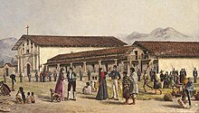
Soon after, on March 28, 1776, Anza established the Presidio of San Francisco. On October 9, Mission San Francisco de Asís, also known as Mission Dolores, was founded by Padre Francisco Palóu.[4] In 1794, the Presidio established the Castillo de San Joaquín, a fortification on the southern side of the Golden Gate, which later came to be known as Fort Point.
In 1804, the province of Alta California was created, which included Yerba Buena ,which was the former name of San Francisco. At its peak in 1810–1820, the average population at the Mission Dolores settlement was about 1,100 people.[60]
Mexican era
[edit]
In 1821, the Californias were ceded to Mexico by Spain. The extensive California mission system gradually lost its influence during the period of Mexican rule. Agricultural land became largely privatized as ranchos, as was occurring in other parts of California. Coastal trade increased, including a half-dozen barques from various Atlantic ports which regularly sailed in California waters.[62][63]
Yerba Buena (after a native herb), a trading post with settlements between the Presidio and Mission grew up around the Plaza de Yerba Buena. The plaza was later renamed Portsmouth Square (now located in the city's Chinatown and Financial District). The Presidio was commanded in 1833 by Captain Mariano G. Vallejo.[62]
In 1833, Juana Briones de Miranda built her rancho near El Polín Spring, founding the first civilian household in San Francisco, which had previously only been comprised by the military settlement at the Presidio and the religious settlement at Mission Dolores.[61]
In 1834, Francisco de Haro became the first Alcalde of Yerba Buena. De Haro was a native of Mexico, from that nation's west coast city of Compostela, Nayarit. A land survey of Yerba Buena was made by the Swiss immigrant Jean Jacques Vioget as prelude to the city plan. The second Alcalde José Joaquín Estudillo was a Californio from a prominent Monterey family. In 1835, while in office, he approved the first land grant in Yerba Buena: to William Richardson, a naturalized Mexican citizen of English birth. Richardson had arrived in San Francisco aboard a whaling ship in 1822. In 1825, he married Maria Antonia Martinez, eldest daughter of the Californio Ygnacio Martínez.[64][a]

Yerba Buena began to attract American and European settlers; an 1842 census listed 21 residents (11%) born in the United States or Europe, as well as one Filipino merchant.[65] Following the Bear Flag Revolt in Sonoma and the beginning of the U.S. Conquest of California, American forces under the command of John B. Montgomery captured Yerba Buena on July 9, 1846, with little resistance from the local Californio population. At the end of the month, the Brooklyn arrived with a group of Mormon settlers, who had departed New York City six months earlier. Following the capture, U.S. forces appointed both José de Jesús Noé and Washington Allon Bartlett to serve as co-alcaldes (mayors), while the conquest continued on in the rest of California. Following the Treaty of Guadalupe Hidalgo in 1848, Alta California was ceded from Mexico to the United States.
Post-Conquest era
[edit]
Despite its attractive location as a port and naval base, post-Conquest San Francisco was still a small settlement with inhospitable geography.[66] Its 1847 population was said to be 459.[62]
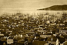
The California gold rush brought a flood of treasure seekers (known as "forty-niners," as in "1849"). With their sourdough bread in tow,[67] prospectors accumulated in San Francisco over rival Benicia,[68] raising the population from 1,000 in 1848 to 25,000 by December 1849.[69] The promise of wealth was so strong that crews on arriving vessels deserted and rushed off to the gold fields, leaving behind a forest of masts in San Francisco harbor.[70] Some of these approximately 500 abandoned ships were used at times as storeships, saloons, and hotels; many were left to rot, and some were sunk to establish title to the underwater lot. By 1851, the harbor was extended out into the bay by wharves while buildings were erected on piles among the ships. By 1870, Yerba Buena Cove had been filled to create new land. Buried ships are occasionally exposed when foundations are dug for new buildings.[71]
California was quickly granted statehood in 1850, and the U.S. military built Fort Point at the Golden Gate and a fort on Alcatraz Island to secure the San Francisco Bay. San Francisco County was one of the state's 18 original counties established at California statehood in 1850.[72] Until 1856, San Francisco's city limits extended west to Divisadero Street and Castro Street, and south to 20th Street. In 1856, the California state government divided the county. A straight line was then drawn across the tip of the San Francisco Peninsula just north of San Bruno Mountain. Everything south of the line became the new San Mateo County while everything north of the line became the new consolidated City and County of San Francisco.[73]
Entrepreneurs sought to capitalize on the wealth generated by the gold rush. Silver discoveries, including the Comstock Lode in Nevada in 1859, further drove rapid population growth.[75] With hordes of fortune seekers streaming through the city, lawlessness was common, and the Barbary Coast section of town gained notoriety as a haven for criminals, prostitution, bootlegging, and gambling.[76] Early winners were the banking industry, with the founding of Wells Fargo in 1852 and the Bank of California in 1864.
Development of the Port of San Francisco and the establishment in 1869 of overland access to the eastern U.S. rail system via the newly completed Pacific Railroad (the construction of which the city only reluctantly helped support[77]) helped make the Bay Area a center for trade. Catering to the needs and tastes of the growing population, Levi Strauss opened a dry goods business and Domingo Ghirardelli began manufacturing chocolate. Chinese immigrants made the city a polyglot culture, drawn to "Old Gold Mountain," creating the city's Chinatown quarter. By 1880, Chinese made up 9.3% of the population.[78]

The first cable cars carried San Franciscans up Clay Street in 1873. The city's sea of Victorian houses began to take shape, and civic leaders campaigned for a spacious public park, resulting in plans for Golden Gate Park. San Franciscans built schools, churches, theaters, and all the hallmarks of civic life. The Presidio developed into the most important American military installation on the Pacific coast.[79] By 1890, San Francisco's population approached 300,000, making it the eighth-largest city in the United States at the time. Around 1901, San Francisco was a major city known for its flamboyant style, stately hotels, ostentatious mansions on Nob Hill, and a thriving arts scene.[80] The first North American plague epidemic was the San Francisco plague of 1900–1904.[81]
1906 earthquake and interwar era
[edit]
At 5:12 am on April 18, 1906, a major earthquake struck San Francisco and northern California. As buildings collapsed from the shaking, ruptured gas lines ignited fires that spread across the city and burned out of control for several days. With water mains out of service, the Presidio Artillery Corps attempted to contain the inferno by dynamiting blocks of buildings to create firebreaks.[82] More than three-quarters of the city lay in ruins, including almost all of the downtown core.[29] Contemporary accounts reported that 498 people died, though modern estimates put the number in the several thousands.[83] More than half of the city's population of 400,000 was left homeless.[84] Refugees settled temporarily in makeshift tent villages in Golden Gate Park, the Presidio, on the beaches, and elsewhere. Many fled permanently to the East Bay. Jack London is remembered for having famously eulogized the earthquake: "Not in history has a modern imperial city been so completely destroyed. San Francisco is gone."[85]

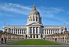
Rebuilding was rapid and performed on a grand scale. Rejecting calls to completely remake the street grid, San Franciscans opted for speed.[86] Amadeo Giannini's Bank of Italy, later to become Bank of America, provided loans for many of those whose livelihoods had been devastated. The influential San Francisco Planning and Urban Research Association or SPUR was founded in 1910 to address the quality of housing after the earthquake.[87] The earthquake hastened development of western neighborhoods that survived the fire, including Pacific Heights, where many of the city's wealthy rebuilt their homes.[88] In turn, the destroyed mansions of Nob Hill became grand hotels. City Hall rose again in the Beaux Arts style, and the city celebrated its rebirth at the Panama–Pacific International Exposition in 1915.[89]

During this period, San Francisco built some of its most important infrastructure. Civil Engineer Michael O'Shaughnessy was hired by San Francisco Mayor James Rolph as chief engineer for the city in September 1912 to supervise the construction of the Twin Peaks Reservoir, the Stockton Street Tunnel, the Twin Peaks Tunnel, the San Francisco Municipal Railway, the Auxiliary Water Supply System, and new sewers. San Francisco's streetcar system, of which the J, K, L, M, and N lines survive today, was pushed to completion by O'Shaughnessy between 1915 and 1927. It was the O'Shaughnessy Dam, Hetch Hetchy Reservoir, and Hetch Hetchy Aqueduct that would have the largest effect on San Francisco.[90] An abundant water supply enabled San Francisco to develop into the city it has become today.

In ensuing years, the city solidified its standing as a financial capital; in the wake of the 1929 stock market crash, not a single San Francisco-based bank failed.[91] Indeed, it was at the height of the Great Depression that San Francisco undertook two great civil engineering projects, simultaneously constructing the San Francisco–Oakland Bay Bridge and the Golden Gate Bridge, completing them in 1936 and 1937, respectively. It was in this period that the island of Alcatraz, a former military stockade, began its service as a federal maximum security prison, housing notorious inmates such as Al Capone, and Robert Franklin Stroud, the Birdman of Alcatraz. San Francisco later celebrated its regained grandeur with a World's fair, the Golden Gate International Exposition in 1939–40, creating Treasure Island in the middle of the bay to house it.[92]
Contemporary era
[edit]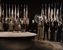
During World War II, the city-owned Sharp Park in Pacifica was used as an internment camp to detain Japanese Americans.[93] Hunters Point Naval Shipyard became a hub of activity, and Fort Mason became the primary port of embarkation for service members shipping out to the Pacific Theater of Operations.[30] The explosion of jobs drew many people, especially African Americans from the South, to the area. After the end of the war, many military personnel returning from service abroad and civilians who had originally come to work decided to stay. The United Nations Charter creating the United Nations was drafted and signed in San Francisco in 1945 and, in 1951, the Treaty of San Francisco re-established peaceful relations between Japan and the Allied Powers.[94]
Urban planning projects in the 1950s and 1960s involved widespread destruction and redevelopment of west-side neighborhoods and the construction of new freeways, of which only a series of short segments were built before being halted by citizen-led opposition.[95] The onset of containerization made San Francisco's small piers obsolete, and cargo activity moved to the larger Port of Oakland.[96] The city began to lose industrial jobs and turned to tourism as the most important segment of its economy.[97] The suburbs experienced rapid growth, and San Francisco underwent significant demographic change, as large segments of the white population left the city, supplanted by an increasing wave of immigration from Asia and Latin America.[98][99] From 1950 to 1980, the city lost over 10 percent of its population.
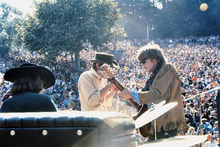
Over this period, San Francisco became a magnet for America's counterculture movement. Beat Generation writers fueled the San Francisco Renaissance and centered on the North Beach neighborhood in the 1950s.[100] Hippies flocked to Haight-Ashbury in the 1960s, reaching a peak with the 1967 Summer of Love.[101] In 1974, the Zebra murders left at least 16 people dead.[102] In the 1970s, the city became a center of the gay rights movement, with the emergence of The Castro as an urban gay village, the election of Harvey Milk to the Board of Supervisors, and his assassination, along with that of Mayor George Moscone, in 1978.[103]
Bank of America, now based in Charlotte, North Carolina, was founded in San Francisco; the bank completed 555 California Street in 1969. The Transamerica Pyramid was completed in 1972,[104] igniting a wave of "Manhattanization" that lasted until the late 1980s, a period of extensive high-rise development downtown.[105] The 1980s also saw a dramatic increase in the number of homeless people in the city, an issue that remains today, despite many attempts to address it.[106]
The 1989 Loma Prieta earthquake caused destruction and loss of life throughout the Bay Area. In San Francisco, the quake severely damaged structures in the Marina and South of Market districts and precipitated the demolition of the damaged Embarcadero Freeway and much of the damaged Central Freeway, allowing the city to reclaim The Embarcadero as its historic downtown waterfront and revitalizing the Hayes Valley neighborhood.[107]
The two recent decades have seen booms driven by the internet industry. During the dot-com boom of the late 1990s, startup companies invigorated the San Francisco economy. Large numbers of entrepreneurs and computer application developers moved into the city, followed by marketing, design, and sales professionals, changing the social landscape as once poorer neighborhoods became increasingly gentrified.[108] Demand for new housing and office space ignited a second wave of high-rise development, this time in the South of Market district.[109] By 2000, the city's population reached new highs, surpassing the previous record set in 1950. When the bubble burst in 2001 and again in 2023, many of these companies folded and their employees were laid off. Yet high technology and entrepreneurship remain mainstays of the San Francisco economy. By the mid-2000s (decade), the social media boom had begun, with San Francisco becoming a popular location for tech offices and a common place to live for people employed in Silicon Valley companies such as Apple and Google.[110]
The early 2020s featured an exodus of tech companies from Downtown San Francisco in the wake of the COVID-19 pandemic and struggles with homelessness and public drug use. Although some observers have raised the possibility that office vacancies and declining tax revenues could cause San Francisco to enter an economic doom loop,[111][112] other sources have refuted this broad-based characterization of the city as a whole, asserting that the issues of concern are restricted primarily to the urban core of San Francisco.[43][113] As of March 2024, Union Square was in "sorry shape" and had lost its traditional position as the Bay Area's regional shopping hub[114] to Westfield Valley Fair in San Jose.[115]
The Ferry Station Post Office Building, Armour & Co. Building, Atherton House, and YMCA Hotel are historic buildings among dozens of historical landmarks in the city, according to the National Register of Historic Places listings in San Francisco.[116]
Geography
[edit]
San Francisco is located on the West Coast of the United States, at the north end of the San Francisco Peninsula and includes significant stretches of the Pacific Ocean and San Francisco Bay within its boundaries. Several picturesque islands—Alcatraz, Treasure Island and the adjacent Yerba Buena Island, and small portions of Alameda Island, Red Rock Island, and Angel Island—are part of the city. Also included are the uninhabited Farallon Islands, 27 miles (43 km) offshore in the Pacific Ocean. The mainland within the city limits roughly forms a "seven-by-seven-mile square," a common local colloquialism referring to the city's shape, though its total area, including water, is nearly 232 square miles (600 km2).
There are more than 50 hills within the city limits.[117] Some neighborhoods are named after the hill on which they are situated, including Nob Hill, Potrero Hill, and Russian Hill.Near the geographic center of the city, southwest of the downtown area, are a series of less densely populated hills. Twin Peaks, a pair of hills forming one of the city's highest points, forms an overlook spot. San Francisco's tallest hill, Mount Davidson, is 928 feet (283 m) high and is capped with a 103-foot (31 m) tall cross built in 1934.[118] Dominating this area is Sutro Tower, a large red and white radio and television transmission tower reaching 1,811 ft (552 m) above sea level.

The nearby San Andreas and Hayward Faults are responsible for much earthquake activity, although neither physically passes through the city itself. The San Andreas Fault caused the earthquakes in 1906 and 1989. Minor earthquakes occur on a regular basis. The threat of major earthquakes plays a large role in the city's infrastructure development. The city constructed an auxiliary water supply system and has repeatedly upgraded its building codes, requiring retrofits for older buildings and higher engineering standards for new construction.[119] However, there are still thousands of smaller buildings that remain vulnerable to quake damage.[120] USGS has released the California earthquake forecast which models earthquake occurrence in California.[121]
San Francisco's shoreline has grown beyond its natural limits. Entire neighborhoods such as the Marina, Mission Bay, and Hunters Point, as well as large sections of the Embarcadero, sit on areas of landfill. Treasure Island was constructed from material dredged from the bay as well as material resulting from the excavation of the Yerba Buena Tunnel through Yerba Buena Island during the construction of the Bay Bridge. Such land tends to be unstable during earthquakes. The resulting soil liquefaction causes extensive damage to property built upon it, as was evidenced in the Marina district during the 1989 Loma Prieta earthquake.[122] A few natural lakes and creeks (Lake Merced, Mountain Lake, Pine Lake, Lobos Creek, El Polin Spring) are within parks and remain protected in what is essentially their original form, but most of the city's natural watercourses, such as Islais Creek and Mission Creek, have been partially or completely culverted and built over. Since the 1990s, however, the Public Utilities Commission has been studying proposals to daylight or restore some creeks.[123]
Neighborhoods
[edit]
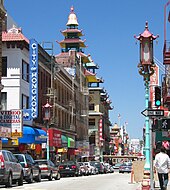
The historic center of San Francisco is the northeast quadrant of the city anchored by Market Street and the waterfront. Here the Financial District is centered, with Union Square, the principal shopping and hotel district, and the Tenderloin nearby. Cable cars carry riders up steep inclines to the summit of Nob Hill, once the home of the city's business tycoons, and down to the waterfront tourist attractions of Fisherman's Wharf, and Pier 39, where many restaurants feature Dungeness crab from a still-active fishing industry. Also in this quadrant are Russian Hill, a residential neighborhood with the famously crooked Lombard Street; North Beach, the city's Little Italy and the former center of the Beat Generation; and Telegraph Hill, which features Coit Tower. Abutting Russian Hill and North Beach is San Francisco's Chinatown, the oldest Chinatown in North America.[124][125][126][127] The South of Market, which was once San Francisco's industrial core, has seen significant redevelopment following the construction of Oracle Park and an infusion of startup companies. New skyscrapers, live-work lofts, and condominiums dot the area. Further development is taking place just to the south in Mission Bay area, a former railroad yard, which now has a second campus of the University of California, San Francisco and Chase Center, which opened in 2019 as the new home of the Golden State Warriors.[128]
West of downtown, across Van Ness Avenue, lies the large Western Addition neighborhood, which became established with a large African American population after World War II. The Western Addition is usually divided into smaller neighborhoods including Hayes Valley, the Fillmore, and Japantown, which was once the largest Japantown in North America but suffered when its Japanese American residents were forcibly removed and interned during World War II. The Western Addition survived the 1906 earthquake with its Victorians largely intact, including the famous "Painted Ladies," standing alongside Alamo Square. To the south, near the geographic center of the city is Haight-Ashbury, famously associated with 1960s hippie culture.[129] The Haight is now[timeframe?] home to some expensive boutiques[130][better source needed] and a few controversial chain stores,[131] although it still retains[timeframe?][citation needed] some bohemian character.
North of the Western Addition is Pacific Heights, an affluent neighborhood that features the homes built by wealthy San Franciscans in the wake of the 1906 earthquake. Directly north of Pacific Heights facing the waterfront is the Marina, a neighborhood popular with young professionals that was largely built on reclaimed land from the Bay.[132]
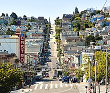
In the southeast quadrant of the city is the Mission District—populated in the 19th century by Californios and working-class immigrants from Germany, Ireland, Italy, and Scandinavia. In the 1910s, a wave of Central American immigrants settled in the Mission and, in the 1950s, immigrants from Mexico began to predominate.[133] In recent years, gentrification has changed the demographics of parts of the Mission from Latino, to twenty-something professionals. Noe Valley to the southwest and Bernal Heights to the south are both increasingly popular among young families with children. East of the Mission is the Potrero Hill neighborhood, a mostly residential neighborhood that features sweeping views of downtown San Francisco. West of the Mission, the area historically known as Eureka Valley, now popularly called the Castro, was once a working-class Scandinavian and Irish area. It has become North America's first gay village, and is now the center of gay life in the city.[134] Located near the city's southern border, the Excelsior District is one of the most ethnically diverse neighborhoods in San Francisco. The Bayview-Hunters Point in the far southeast corner of the city is one of the poorest neighborhoods, though the area has been the focus of several revitalizing and urban renewal projects.
The construction of the Twin Peaks Tunnel in 1918 connected southwest neighborhoods to downtown via streetcar, hastening the development of West Portal, and nearby affluent Forest Hill and St. Francis Wood. Further west, stretching all the way to the Pacific Ocean and north to Golden Gate Park lies the vast Sunset District, a large middle-class area with a predominantly Asian population.[135]
The northwestern quadrant of the city contains the Richmond, a mostly middle-class neighborhood north of Golden Gate Park, home to immigrants from other parts of Asia as well as many Russian and Ukrainian immigrants. Together, these areas are known as The Avenues. These two districts are each sometimes further divided into two regions: the Outer Richmond and Outer Sunset can refer to the more western portions of their respective district and the Inner Richmond and Inner Sunset can refer to the more eastern portions.
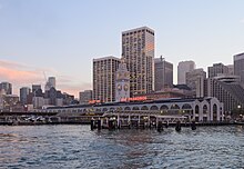
Many piers remained derelict for years until the demolition of the Embarcadero Freeway reopened the downtown waterfront, allowing for redevelopment. The centerpiece of the port, the Ferry Building, while still receiving commuter ferry traffic, has been restored and redeveloped as a gourmet marketplace.
Climate
[edit]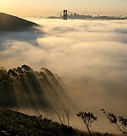
San Francisco has a warm-summer Mediterranean climate (Köppen: Csb), characteristic of California's coast, with moist winters and dry summers.[136] San Francisco's weather is strongly influenced by the cool currents of the Pacific Ocean on the west side of the city, and the water of San Francisco Bay to the north and east. This moderates temperature swings and produces a remarkably mild year-round climate with little seasonal temperature variation.[137]
Among major U.S. cities, San Francisco has the coolest daily mean, maximum, and minimum temperatures for June, July, and August.[138]During the summer, rising hot air in California's interior valleys creates a low-pressure area that draws winds from the North Pacific High through the Golden Gate, which creates the city's characteristic cool winds and fog.[139] The fog is less pronounced in eastern neighborhoods and during the late summer and early fall. As a result, the year's warmest month, on average, is September, and on average, October is warmer than July, especially in daytime.
Temperatures reach or exceed 80 °F (27 °C) on an average of only 21 and 23 days a year at downtown and San Francisco International Airport (SFO), respectively.[140] The dry period of May to October is mild to warm, with the normal monthly mean temperature peaking in September at 62.7 °F (17.1 °C).[140] The rainy period of November to April is slightly cooler, with the normal monthly mean temperature reaching its lowest in January at 51.3 °F (10.7 °C).[140] On average, there are 73 rainy days a year, and annual precipitation averages 23.65 inches (601 mm).[140] Variation in precipitation from year to year is high. Above-average rain years are often associated with warm El Niño conditions in the Pacific while dry years often occur in cold water La Niña periods. In 2013 (a "La Niña" year), a record low 5.59 in (142 mm) of rainfall was recorded at downtown San Francisco, where records have been kept since 1849.[140] Snowfall in the city is very rare, with only 10 measurable accumulations recorded since 1852, most recently in 1976 when up to 5 inches (13 cm) fell on Twin Peaks.[141][142]

The highest recorded temperature at the official National Weather Service downtown observation station[b] was 106 °F (41 °C) on September 1, 2017.[144] During that hot spell, the warmest ever night of 71 °F (22 °C) was also recorded.[145] The lowest recorded temperature was 27 °F (−3 °C) on December 11, 1932.[146]
During an average year between 1991 and 2020, San Francisco recorded a warmest night at 64 °F (18 °C) and a coldest day at 49 °F (9 °C).[140] The coldest daytime high since the station's opening in 1945 was recorded in December 1972 at 37 °F (3 °C).[140]
As a coastal city, San Francisco will be heavily affected by climate change. As of 2021[update], sea levels are projected to rise by as much as 5 feet (1.5 m), resulting in periodic flooding, rising groundwater levels, and lowland floods from more severe storms.[147]
San Francisco falls under the USDA 10b Plant hardiness zone, though some areas, particularly downtown, border zone 11a.[148][149]
| Month | Jan | Feb | Mar | Apr | May | Jun | Jul | Aug | Sep | Oct | Nov | Dec | Year |
|---|---|---|---|---|---|---|---|---|---|---|---|---|---|
| Record high °F (°C) | 79 (26) | 81 (27) | 87 (31) | 94 (34) | 97 (36) | 103 (39) | 99 (37) | 98 (37) | 106 (41) | 102 (39) | 86 (30) | 76 (24) | 106 (41) |
| Mean maximum °F (°C) | 67.1 (19.5) | 71.8 (22.1) | 76.4 (24.7) | 80.7 (27.1) | 81.4 (27.4) | 84.6 (29.2) | 80.5 (26.9) | 83.4 (28.6) | 90.8 (32.7) | 87.9 (31.1) | 75.8 (24.3) | 66.4 (19.1) | 94.0 (34.4) |
| Mean daily maximum °F (°C) | 57.8 (14.3) | 60.4 (15.8) | 62.1 (16.7) | 63.0 (17.2) | 64.1 (17.8) | 66.5 (19.2) | 66.3 (19.1) | 67.9 (19.9) | 70.2 (21.2) | 69.8 (21.0) | 63.7 (17.6) | 57.9 (14.4) | 64.1 (17.8) |
| Daily mean °F (°C) | 52.2 (11.2) | 54.2 (12.3) | 55.5 (13.1) | 56.4 (13.6) | 57.8 (14.3) | 59.7 (15.4) | 60.3 (15.7) | 61.7 (16.5) | 62.9 (17.2) | 62.1 (16.7) | 57.2 (14.0) | 52.5 (11.4) | 57.7 (14.3) |
| Mean daily minimum °F (°C) | 46.6 (8.1) | 47.9 (8.8) | 48.9 (9.4) | 49.7 (9.8) | 51.4 (10.8) | 53.0 (11.7) | 54.4 (12.4) | 55.5 (13.1) | 55.6 (13.1) | 54.4 (12.4) | 50.7 (10.4) | 47.0 (8.3) | 51.3 (10.7) |
| Mean minimum °F (°C) | 40.5 (4.7) | 42.0 (5.6) | 43.7 (6.5) | 45.0 (7.2) | 48.0 (8.9) | 50.1 (10.1) | 51.6 (10.9) | 52.9 (11.6) | 52.0 (11.1) | 49.9 (9.9) | 44.9 (7.2) | 40.7 (4.8) | 38.8 (3.8) |
| Record low °F (°C) | 29 (−2) | 31 (−1) | 33 (1) | 40 (4) | 42 (6) | 46 (8) | 47 (8) | 46 (8) | 47 (8) | 43 (6) | 38 (3) | 27 (−3) | 27 (−3) |
| Average precipitation inches (mm) | 4.40 (112) | 4.37 (111) | 3.15 (80) | 1.60 (41) | 0.70 (18) | 0.20 (5.1) | 0.01 (0.25) | 0.06 (1.5) | 0.10 (2.5) | 0.94 (24) | 2.60 (66) | 4.76 (121) | 22.89 (581) |
| Average precipitation days (≥ 0.01 in) | 11.2 | 10.8 | 10.8 | 6.8 | 4.0 | 1.6 | 0.7 | 1.1 | 1.2 | 3.5 | 7.9 | 11.6 | 71.2 |
| Average relative humidity (%) | 80 | 77 | 75 | 72 | 72 | 71 | 75 | 75 | 73 | 71 | 75 | 78 | 75 |
| Mean monthly sunshine hours | 185.9 | 207.7 | 269.1 | 309.3 | 325.1 | 311.4 | 313.3 | 287.4 | 271.4 | 247.1 | 173.4 | 160.6 | 3,061.7 |
| Percent possible sunshine | 61 | 69 | 73 | 78 | 74 | 70 | 70 | 68 | 73 | 71 | 57 | 54 | 69 |
| Average ultraviolet index | 2 | 3 | 5 | 7 | 9 | 10 | 10 | 9 | 7 | 5 | 3 | 2 | 6 |
| Source 1: NOAA (sun 1961–1974)[140][150][151][152] | |||||||||||||
| Source 2: Met Office (humidity),[153] Weather Atlas (UV)[154] | |||||||||||||
Ecology
[edit]
Historically, tule elk were present in San Francisco County, based on archeological evidence of elk remains in at least five different Native American shellmounds: at Hunter's Point, Fort Mason, Stevenson Street, Market Street, and Yerba Buena.[155][156] Perhaps the first historical observer record was from the De Anza Expedition on March 23, 1776. Herbert Eugene Bolton wrote about the expedition camp at Mountain Lake, near the southern end of today's Presidio: "Round about were grazing deer, and scattered here and there were the antlers of large elk."[157] Also, when Richard Henry Dana Jr. visited San Francisco Bay in 1835, he wrote about vast elk herds near the Golden Gate: on December 27 ."..we came to anchor near the mouth of the bay, under a high and beautifully sloping hill, upon which herds of hundreds and hundreds of red deer [note: "red deer" is the European term for "elk"], and the stag, with his high branching antlers, were bounding about...," although it is not clear whether this was the Marin side or the San Francisco side.[158]
Demographics
[edit]| Year | Pop. | ±% |
|---|---|---|
| 1848 | 1,000 | — |
| 1849 | 25,000 | +2400.0% |
| 1852 | 34,776 | +39.1% |
| 1860 | 56,802 | +63.3% |
| 1870 | 149,473 | +163.1% |
| 1880 | 233,959 | +56.5% |
| 1890 | 298,997 | +27.8% |
| 1900 | 342,782 | +14.6% |
| 1910 | 416,912 | +21.6% |
| 1920 | 506,676 | +21.5% |
| 1930 | 634,394 | +25.2% |
| 1940 | 634,536 | +0.0% |
| 1950 | 775,357 | +22.2% |
| 1960 | 740,316 | −4.5% |
| 1970 | 715,674 | −3.3% |
| 1980 | 678,974 | −5.1% |
| 1990 | 723,959 | +6.6% |
| 2000 | 776,733 | +7.3% |
| 2010 | 805,235 | +3.7% |
| 2020 | 873,965 | +8.5% |
| 2023 | 808,988 | −7.4% |
| https://www.sfchronicle.com/sf/article/s-f-exodus-population-recovery-data-18564064.php | ||
The 2020 United States census showed San Francisco's population to be 873,965, an increase of 8.5% from the 2010 census.[16] With roughly one-quarter the population density of Manhattan, San Francisco is the second-most densely populated large American city, behind only New York City among cities greater than 200,000 population, and the fifth-most densely populated U.S. county, following only four of the five New York City boroughs.
San Francisco is part of the five-county San Francisco–Oakland–Hayward, CA Metropolitan Statistical Area, a region of 4.7 million people (13th most populous in the U.S.), and has served as its traditional demographic focal point. It is also part of the greater 14-county San Jose-San Francisco-Oakland, CA Combined Statistical Area, whose population is over 9.6 million, making it the fifth-largest in the United States as of 2018[update].[159][failed verification]
Race, ethnicity, religion, and languages
[edit]
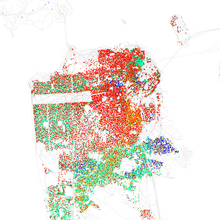
As of the 2020[update] census, the racial makeup and population of San Francisco included: 361,382 Whites (41.3%), 296,505 Asians (33.9%), 46,725 African Americans (5.3%), 86,233 Multiracial Americans (9.9%), 6,475 Native Americans and Alaska Natives (0.7%), 3,476 Native Hawaiians and other Pacific Islanders (0.4%) and 73,169 persons of other races (8.4%). There were 136,761 Hispanic or Latino residents of any race (15.6%).
San Francisco is a majority minority city, as non-Hispanic White residents comprise less than half of the population; in 1940 they formed 92.5% of the population.[160]
In 2010, residents of Chinese ethnicity constituted the largest single ethnic minority group in San Francisco at 21% of the population; other large Asian groups include Filipinos (5%) and Vietnamese (2%), with Japanese, Koreans and many other Asian and Pacific Islander groups represented in the city.[161] The population of Chinese ancestry is most heavily concentrated in Chinatown and the Sunset and Richmond Districts. Filipinos are most concentrated in SoMa and the Crocker-Amazon; the latter neighborhood shares a border with Daly City, which has one of the highest concentrations of Filipinos in North America.[161][162] The Tenderloin District is home to a large portion of the city's Vietnamese population as well as businesses and restaurants, which is known as the city's Little Saigon.[161]
The principal Hispanic groups in the city were those of Mexican (7%) and Salvadoran (2%) ancestry. The Hispanic population is most heavily concentrated in the Mission District, Tenderloin District, and Excelsior District.[163] The city's percentage of Hispanic residents is less than half of that of the state.
African Americans constituted about 5% of San Francisco's population in 2020; their share of the city's population has been decreasing since the 1970s.[164] The majority of the city's Black residents live in the neighborhoods of Bayview-Hunters Point, Visitacion Valley, and the Fillmore District.[163] There are smaller Black communities in Diamond Heights, Glen Park, and Mission District.
The city has long been home to a significant Jewish community; in 2018 Jewish Americans made up an estimated 10% (80,000) of the city's population. It the third-largest Jewish community in proportional terms in the United States, behind only those of New York City, and Los Angeles, respectively, and it is also relatively young compared to other major U.S. cities.[165] The Jewish community resides throughout the city, but the Richmond District is home to an ethnic enclave of mostly Russian Jews.[166] The Fillmore District was formerly a mostly Jewish neighborhood from the 1920s until the 1970s, when many of its Jewish residents moved to other neighborhoods of the city as well as the suburbs of nearby Marin County.[167]
Source: U.S. Census and IPUMS USA[168] | ||||||||||||||||||||||||||||||||||||||||||||||||||||||||||||||||||||||||||||||||||||||||||||||||||||||||||||||||||||||||||||||||||||||||||||
According to a 2018 study by the Jewish Community Federation of San Francisco, Jews make up 10% (80,000) of the city's population, making Judaism the second-largest religion in San Francisco after Christianity.[165] A prior 2014 study by the Pew Research Center, the largest religious groupings in San Francisco's metropolitan area are Christians (48%), followed by those of no religion (35%), Hindus (5%), Jews (3%), Buddhists (2%), Muslims (1%) and a variety of other religions have smaller followings. According to the same study by the Pew Research Center, about 20% of residents in the area are Protestant, and 25% professing Roman Catholic beliefs. Meanwhile, 10% of the residents in metropolitan San Francisco identify as agnostics, while 5% identify as atheists.[170][171]
As of 2010[update], 55% (411,728) of San Francisco residents spoke only English at home, while 19% (140,302) spoke a variety of Chinese (mostly Taishanese and Cantonese[172][173]), 12% (88,147) Spanish, 3% (25,767) Tagalog, and 2% (14,017) Russian. In total, 45% (342,693) of San Francisco's population spoke a language at home other than English.[174]
Ethnic clustering
[edit]San Francisco has several prominent Chinese, Mexican, and Filipino neighborhoods including Chinatown and the Mission District. Research collected on the immigrant clusters in the city show that more than half of the Asian population in San Francisco is either Chinese-born (40.3%) or Philippine-born (13.1%), and of the Mexican population 21% were Mexican-born, meaning these are people who recently immigrated to the United States.[175] Between the years of 1990 and 2000, the number of foreign-born residents increased from 33% to nearly 40%.[175] During this same time period, the San Francisco metropolitan area received 850,000 immigrants, ranking third in the United States after Los Angeles and New York.[175]
Education, households, and income
[edit]
Of all major cities in the United States, San Francisco has the second-highest percentage of residents with a college degree, second only to Seattle. Over 44% of adults have a bachelor's or higher degree.[177]San Francisco had the highest rate at 7,031 per square mile, or over 344,000 total graduates in the city's 46.7 square miles (121 km2).[178]
San Francisco has the highest estimated percentage of gay and lesbian individuals of any of the 50 largest U.S. cities, at 15%.[179]San Francisco also has the highest percentage of same-sex households of any American county, with the Bay Area having a higher concentration than any other metropolitan area.[180]
San Francisco ranks third of American cities in median household income[181] with a 2007 value of $65,519.[182] Median family income is $81,136.[182]An emigration of middle-class families has left the city with a lower proportion of children than any other large American city,[183] with the dog population cited as exceeding the child population of 115,000, in 2018.[184]The city's poverty rate is 12%, lower than the national average.[185]Homelessness has been a chronic problem for San Francisco since the early 1970s.[186]The city is believed to have the highest number of homeless inhabitants per capita of any major U.S. city.[187][188]
There are 345,811 households in the city, out of which: 133,366 households (39%) were individuals, 109,437 (32%) were opposite-sex married couples, 63,577 (18%) had children under the age of 18 living in them, 21,677 (6%) were unmarried opposite-sex partnerships, and 10,384 (3%) were same-sex married couples or partnerships. The average household size was 2.26; the average family size was 3.11. 452,986 people (56%) lived in rental housing units, and 327,985 people (41%) lived in owner-occupied housing units.The median age of the city population is 38 years.
San Francisco declared itself a sanctuary city in 1989, and city officials strengthened the stance in 2013 with its 'Due Process for All' ordinance. The law declared local authorities could not hold immigrants for immigration offenses if they had no violent felonies on their records and did not currently face charges."[189] The city issues a Resident ID Card regardless of the applicant's immigration status.[190]
Homelessness
[edit]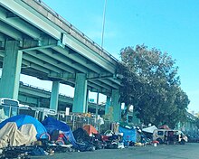
Homelessness in San Francisco emerged as a major issue in the late 20th century and remains a growing problem in modern times.[191]
8,035 homeless people were counted in San Francisco's 2019 point-in-time street and shelter count. This was an increase of more than 17% over the 2017 count of 6,858 people. 5,180 of the people were living unsheltered on the streets and in parks.[192] 26% of respondents in the 2019 count identified job loss as the primary cause of their homelessness, 18% cited alcohol or drug use, and 13% cited being evicted from their residence.[192] The city of San Francisco has been dramatically increasing its spending to service the growing population homelessness crisis: spending jumped by $241 million in 2016–17 to total $275 million, compared to a budget of just $34 million the previous year. In 2017–18 the budget for combatting homelessness stood at $305 million.[193] In the 2019–2020 budget year, the city budgeted $368 million for homelessness services. In the proposed 2020–2021 budget the city budgeted $850 million for homelessness services.[194]
In January 2018 a United Nations special rapporteur on homelessness, Leilani Farha, stated that she was "completely shocked" by San Francisco's homelessness crisis during a visit to the city. She compared the "deplorable conditions" of the homeless camps she witnessed on San Francisco's streets to those she had seen in Mumbai.[193] In May 2020, San Francisco officially sanctioned homeless encampments.[195]
Crime
[edit]This article needs to be updated. (March 2024) |

San Francisco's violent crime rate is low compared to other major cities, though many residents are still concerned about it.[196]
In 2011, 50 murders were reported, which is 6.1 per 100,000 people.[197] There were about 134 rapes, 3,142 robberies, and about 2,139 assaults. There were about 4,469 burglaries, 25,100 thefts, and 4,210 motor vehicle thefts.[198] The Tenderloin area has the highest crime rate in San Francisco: 70% of the city's violent crimes, and around one-fourth of the city's murders, occur in this neighborhood. The Tenderloin also sees high rates of drug abuse, gang violence, and prostitution.[199] Another area with high crime rates is the Bayview-Hunters Point area. In the first six months of 2015 there were 25 murders compared to 14 in the first six months of 2014. However, the murder rate is still much lower than in past decades.[200] That rate, though, did rise again by the close of 2016. According to the San Francisco Police Department, there were 59 murders in the city in 2016, an annual total that marked a 13.5% increase in the number of homicides (52) from 2015.[201] The city has also gained a reputation for car break-ins, with over 19,000 car break-ins occurring in 2021.[202]
During the first half of 2018, human feces on San Francisco sidewalks were the second-most-frequent complaint of city residents, with about 65 calls per day. The city has formed a "poop patrol" to attempt to combat the problem.[203]
In January 2022, CBS News reported that a single suspect was "responsible for more than half of all reported hate crimes against the API community in San Francisco last year," and that he "was allowed to be out of custody despite the number of charges against him."[204]
Several street gangs have operated in the city over the decades, including MS-13,[205] the Sureños and Norteños in the Mission District.[206]
African-American street gangs familiar in other cities, including the Bloods, Crips and their sets, have struggled to establish footholds in San Francisco,[207] while police and prosecutors have been accused of liberally labeling young African-American males as gang members.[208]
Criminal gangs with shot callers in China, including Triad groups such as the Wo Hop To, were active in San Francisco in the 20th century.[209] According to statistics released by SFPD in April 2024, the crime figures were down in the first 100 days of the year, namely in terms of robberies, burglaries and larceny.[210]
Economy
[edit]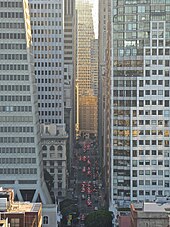
The city has a diversified service economy, with employment spread across a wide range of professional services, including tourism, financial services, and (increasingly) high technology.[212] In 2016, approximately 27% of workers were employed in professional business services; 14% in leisure and hospitality; 13% in government services; 12% in education and health care; 11% in trade, transportation, and utilities; and 8% in financial activities.[212] In 2019, GDP in the five-county San Francisco metropolitan area grew 3.8% in real terms to $592 billion.[213][214] Additionally, in 2019 the 14-county San Jose–San Francisco–Oakland combined statistical area had a GDP of $1.086 trillion,[214] ranking 3rd among CSAs, and ahead of all but 16 countries. As of 2019[update], San Francisco County was the 7th highest-income county in the United States (among 3,142), with a per capita personal income of $139,405.[215] Marin County, directly to the north over the Golden Gate Bridge, and San Mateo County, directly to the south on the Peninsula, were the 6th and 9th highest-income counties respectively.

The legacy of the California gold rush turned San Francisco into the principal banking and finance center of the West Coast in the early twentieth century.[216] Montgomery Street in the Financial District became known as the "Wall Street of the West," home to the Federal Reserve Bank of San Francisco, and the site of the now-defunct Pacific Coast Stock Exchange.[216] Bank of America, a pioneer in making banking services accessible to the middle class, was founded in San Francisco and in the 1960s, built the landmark modern skyscraper at 555 California Street for its corporate headquarters, since relocated to Charlotte, North Carolina. Many large financial institutions, multinational banks, and venture capital firms are based in or have regional headquarters in the city. With over 30 international financial institutions,[217] six Fortune 500 companies,[218] and a large supporting infrastructure of professional services—including law, public relations, architecture and design—San Francisco is designated as an Alpha(-) World City.[219] The 2017 Global Financial Centres Index ranked San Francisco as the sixth-most competitive financial center in the world.[220]
Beginning in the 1990s, San Francisco's economy diversified away from finance and tourism towards the growing fields of high tech, biotechnology, and medical research.[221] Technology jobs accounted for just 1 percent of San Francisco's economy in 1990, growing to 4 percent in 2010 and an estimated 8 percent by the end of 2013.[222] San Francisco became a center of Internet start-up companies during the dot-com bubble of the 1990s and the subsequent social media boom of the late 2000s (decade).[223] Since 2010, San Francisco proper has attracted an increasing share of venture capital investments as compared to nearby Silicon Valley, attracting 423 financings worth US$4.58 billion in 2013.[224][225][226] In 2004, the city approved a payroll tax exemption for biotechnology companies[227] to foster growth in the Mission Bay neighborhood, site of a second campus and hospital of the University of California, San Francisco (UCSF). Mission Bay hosts the UCSF Medical Center, the California Institute for Regenerative Medicine, California Institute for Quantitative Biosciences, and Gladstone Institutes,[228] as well as more than 40 private-sector life sciences companies.[229]

According to academic Rob Wilson, San Francisco is a global city, a status that pre-dated the city's popularity during the California gold rush.[231] However, the COVID-19 pandemic has led to high office vacancy rates and the closure of many retail and tech businesses in the downtown core of San Francisco.[232][233] Attributed causes include a shift to remote work in the technology and professional services sectors, as well as high levels of homelessness, drug use, and crime in areas around downtown San Francisco, such as the Tenderloin and Mid-Market neighborhoods.[234][235]
The top employer in San Francisco is the city government itself, employing 5.6% (31,000+ people) of the city's workforce, followed by UCSF with over 25,000 employees.[236] The largest private-sector employer is Salesforce, with 8,500 employees, as of 2018[update].[237] Small businesses with fewer than 10 employees and self-employed firms made up 85% of city establishments in 2006,[238] and the number of San Franciscans employed by firms of more than 1,000 employees has fallen by half since 1977.[239] The growth of national big box and formula retail chains into the city has been made intentionally difficult by political and civic consensus. In an effort to buoy small privately owned businesses in San Francisco and preserve the unique retail personality of the city, the Small Business Commission started a publicity campaign in 2004 to keep a larger share of retail dollars in the local economy,[240] and the Board of Supervisors has used the planning code to limit the neighborhoods where formula retail establishments can set up shop,[241] an effort affirmed by San Francisco voters.[242] However, by 2016, San Francisco was rated low by small businesses in a Business Friendliness Survey.[243]
Like many U.S. cities, San Francisco once had a significant manufacturing sector employing nearly 60,000 workers in 1969, but nearly all production left for cheaper locations by the 1980s.[244] As of 2014[update], San Francisco has seen a small resurgence in manufacturing, with more than 4,000 manufacturing jobs across 500 companies, doubling since 2011. The city's largest manufacturing employer is Anchor Brewing Company, and the largest by revenue is Timbuk2.[244]
As of the first quarter of 2022[update], the median value of homes in San Francisco County was $1,297,030. It ranked third in the U.S. for counties with highest median home value, behind Nantucket, Massachusetts and San Mateo County, California.[245]
Technology
[edit]
San Francisco became a hub for technological driven economic growth during the internet boom of the 1990s, and still holds an important position in the world city network today.[175][246] Intense redevelopment towards the "new economy" makes business more technologically minded. Between the years of 1999 and 2000, the job growth rate was 4.9%, creating over 50,000 jobs in technology firms and internet content production.[175] However, the technology industry has become geographically dispersed.[247][248]
In the second technological boom driven by social media in the mid-2000s, San Francisco became a location for companies such as Apple, Google, Ubisoft, Facebook, and Twitter to base their tech offices and for their employees to live.[249]
Tourism and conventions
[edit]
Tourism is one of San Francisco's most important private-sector industries, accounting for more than one out of seven jobs in the city.[221][250] The city's frequent portrayal in music, film, and popular culture has made the city and its landmarks recognizable worldwide. In 2016, it attracted the fifth-highest number of foreign tourists of any city in the United States.[251] More than 25 million visitors arrived in San Francisco in 2016, adding US$9.96 billion to the economy.[252]With a large hotel infrastructure and a major convention facility in the Moscone Center, San Francisco is a popular destination for annual conventions and conferences.[253]
Some of the most popular tourist attractions in San Francisco, as noted by the Travel Channel, include the Golden Gate Bridge and Alamo Square Park, home to the famous "Painted Ladies." Both of these locations were often used as landscape shots for the hit American television sitcom Full House. There is also Lombard Street, known for its "crookedness" and extensive views. Tourists also visit Pier 39, which offers dining, shopping, entertainment, and views of the bay, sunbathing California sea lions, the Aquarium of the Bay, and the famous Alcatraz Island.[254]

San Francisco also offers tourists varied nightlife in its neighborhoods.[255][256]
The new Terminal Project at Pier 27 opened September 25, 2014, as a replacement for the old Pier 35.[257] Itineraries from San Francisco usually include round-trip cruises to Alaska and Mexico.
A heightened interest in conventioneering in San Francisco, marked by the establishment of convention centers such as Yerba Buena, acted as a feeder into the local tourist economy and resulted in an increase in the hotel industry: "In 1959, the city had fewer than thirty-three hundred first-class hotel rooms; by 1970, the number was nine thousand; and by 1999, there were more than thirty thousand."[258] The commodification of the Castro District has contributed to San Francisco's tourist economy.[259]
Arts and culture
[edit]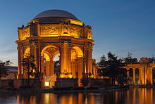
Although the Financial District, Union Square, and Fisherman's Wharf are well known around the world, San Francisco is also characterized by its numerous culturally rich streetscapes featuring mixed-use neighborhoods anchored around central commercial corridors to which residents and visitors alike can walk.[citation needed] Because of these characteristics,[original research?] San Francisco is ranked the "most walkable" city in the United States by Walkscore.com.[260] Many neighborhoods feature a mix of businesses, restaurants and venues that cater to the daily needs of local residents while also serving many visitors and tourists. Some neighborhoods are dotted with boutiques, cafés and nightlife such as Union Street in Cow Hollow, 24th Street in Noe Valley, Valencia Street in the Mission, Grant Avenue in North Beach, and Irving Street in the Inner Sunset. This approach especially has influenced the continuing South of Market neighborhood redevelopment with businesses and neighborhood services rising alongside high-rise residences.[261][failed verification]
Since the 1990s, the demand for skilled information technology workers from local startups and nearby Silicon Valley has attracted white-collar workers from all over the world and created a high standard of living in San Francisco.[263] Many neighborhoods that were once blue-collar, middle, and lower class have been gentrifying, as many of the city's traditional business and industrial districts have experienced a renaissance driven by the redevelopment of the Embarcadero, including the neighborhoods South Beach and Mission Bay. The city's property values and household income have risen to among the highest in the nation,[264][265][266] creating a large and upscale restaurant, retail, and entertainment scene. According to a 2014 quality of life survey of global cities, San Francisco has the highest quality of living of any U.S. city.[267] However, due to the exceptionally high cost of living, many of the city's middle and lower-class families have been leaving the city for the outer suburbs of the Bay Area, or for California's Central Valley.[268] By June 2, 2015, the median rent was reported to be as high as $4,225.[269] The high cost of living is due in part to restrictive planning laws which limit new residential construction.[270]
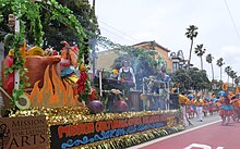
The international character that San Francisco has enjoyed since its founding is continued today by large numbers of immigrants from Asia and Latin America. With 39% of its residents born overseas,[239] San Francisco has numerous neighborhoods filled with businesses and civic institutions catering to new arrivals. In particular, the arrival of many ethnic Chinese, which began to accelerate in the 1970s, has complemented the long-established community historically based in Chinatown throughout the city and has transformed the annual Chinese New Year Parade into the largest event of its kind on the West Coast.
With the arrival of the "beat" writers and artists of the 1950s and societal changes culminating in the Summer of Love in the Haight-Ashbury district during the 1960s, San Francisco became a center of liberal activism and of the counterculture that arose at that time. The Democrats and to a lesser extent the Green Party have dominated city politics since the late 1970s, after the last serious Republican challenger for city office lost the 1975 mayoral election by a narrow margin. San Francisco has not voted more than 20% for a Republican presidential or senatorial candidate since 1988.[271] In 2007, the city expanded its Medicaid and other indigent medical programs into the Healthy San Francisco program,[272] which subsidizes certain medical services for eligible residents.[273][274][275]
Since 1993, the San Francisco Department of Public Health has distributed 400,000 free syringes every month aimed at reducing HIV and other health risks for drug users, as well as providing disposal sites and services.[276][277][278]
San Francisco also has had a very active environmental community. Starting with the founding of the Sierra Club in 1892 to the establishment of the non-profit Friends of the Urban Forest in 1981, San Francisco has been at the forefront of many global discussions regarding the environment.[279][280] The 1980 San Francisco Recycling Program was one of the earliest curbside recycling programs.[281] The city's GoSolarSF incentive promotes solar installations and the San Francisco Public Utilities Commission is rolling out the CleanPowerSF program to sell electricity from local renewable sources.[282][283] SF Greasecycle is a program to recycle used cooking oil for conversion to biodiesel.[284]
The Sunset Reservoir Solar Project, completed in 2010, installed 24,000 solar panels on the roof of the reservoir. The 5-megawatt plant more than tripled the city's 2-megawatt solar generation capacity when it opened in December 2010.[285][286]
LGBT
[edit]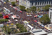
San Francisco has long had an LGBT-friendly history. It was home to the first lesbian-rights organization in the United States, Daughters of Bilitis; the first openly gay person to run for public office in the United States, José Sarria; the first openly gay man to be elected to public office in California, Harvey Milk; the first openly lesbian judge appointed in the U.S., Mary C. Morgan; and the first transgender police commissioner, Theresa Sparks. The city's large gay population has created and sustained a politically and culturally active community over many decades, developing a powerful presence in San Francisco's civic life.[287] Survey data released in 2015 by Gallup places the proportion of LGBT adults in the San Francisco metro area at 6.2%, which is the highest proportion of the 50 most populous metropolitan areas as measured by the polling organization.[288]

One of the most popular destinations for gay tourists internationally, the city hosts San Francisco Pride, one of the largest and oldest pride parades. San Francisco Pride events have been held continuously since 1972. The events are themed and a new theme is created each year.[289] In 2013, over 1.5 million people attended, around 500,000 more than the previous year.[290] Pink Saturday is an annual street party held the Saturday before the pride parade, which coincides with the Dyke march.
The Folsom Street Fair (FSF) is an annual BDSM and leather subculture street fair that is held in September, endcapping San Francisco's "Leather Pride Week."[291] It started in 1984 and is California's third-largest single-day, outdoor spectator event and the world's largest leather event and showcase for BDSM products and culture.[292]
Performing arts
[edit]

San Francisco's War Memorial and Performing Arts Center hosts some of the most enduring performing arts companies in the country. The War Memorial Opera House houses the San Francisco Opera, the second-largest opera company in North America[293] as well as the San Francisco Ballet, while the San Francisco Symphony plays in Davies Symphony Hall. Opened in 2013, the SFJAZZ Center hosts jazz performances year round.[294]
The Fillmore is a music venue located in the Western Addition. It is the second incarnation of the historic venue that gained fame in the 1960s, housing the stage where now-famous musicians such as the Grateful Dead, Janis Joplin, Led Zeppelin, and Jefferson Airplane first performed, fostering the San Francisco Sound.[295] It closed its doors in 1971 with a final performance by Santana and reopened in 1994 with a show by the Smashing Pumpkins.[296]
San Francisco has a large number of theaters and live performance venues. Local theater companies have been noted for risk taking and innovation.[297] The Tony Award-winning non-profit American Conservatory Theater (A.C.T.) is a member of the national League of Resident Theatres. Other local winners of the Regional Theatre Tony Award include the San Francisco Mime Troupe.[298]San Francisco theaters frequently host pre-Broadway engagements and tryout runs,[299] and some original San Francisco productions have later moved to Broadway.[300]
Museums
[edit]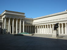
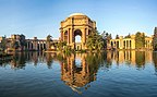
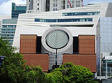
The San Francisco Museum of Modern Art (SFMOMA) houses 20th century and contemporary works of art. It moved to its current building in the South of Market neighborhood in 1995 and attracted more than 600,000 visitors annually.[301] SFMOMA closed for renovation and expansion in 2013. The museum reopened on May 14, 2016, with an addition, designed by Snøhetta, that has doubled the museum's size.[302]
The Palace of the Legion of Honor holds primarily European antiquities and works of art at its Lincoln Park building modeled after its Parisian namesake. The de Young Museum in Golden Gate Park features American decorative pieces and anthropological holdings from Africa, Oceania and the Americas, while Asian art is housed in the Asian Art Museum. Opposite the de Young stands the California Academy of Sciences, a natural history museum that also hosts the Morrison Planetarium and Steinhart Aquarium. Located on Pier 15 on the Embarcadero, the Exploratorium is an interactive science museum. The Contemporary Jewish Museum is a non-collecting institution that hosts a broad array of temporary exhibitions. On Nob Hill, the Cable Car Museum is a working museum featuring the cable car powerhouse, which drives the cables.[303] Wattis Institute for Contemporary Arts was founded in 1998 and is part of the California College of the Arts.[304]
Sports
[edit]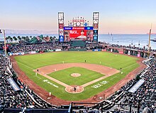
Major League Baseball's San Francisco Giants have played in San Francisco since moving from New York in 1958. The Giants play at Oracle Park, which opened in 2000.[305] The Giants won World Series titles in 2010, 2012, and in 2014. The Giants have boasted stars such as Willie Mays, Willie McCovey, and Barry Bonds (MLB's career home run leader). In 2012, San Francisco was ranked No. 1 in a study that examined which U.S. metro areas have produced the most Major Leaguers since 1920.[306]
The San Francisco 49ers of the National Football League (NFL) began playing in 1946 as an All-America Football Conference (AAFC) league charter member, moved to the NFL in 1950 and into Candlestick Park in 1971. The team left San Francisco in 2014, moving approximately 50 miles south to Santa Clara, and began playing its home games at Levi's Stadium,[307][308] The 49ers have won five Super Bowl titles between 1982 and 1995.

The NBA's Golden State Warriors have played in the San Francisco Bay Area since moving from Philadelphia in 1962. The Warriors played as the San Francisco Warriors, from 1962 to 1971, before being renamed the Golden State Warriors prior to the 1971–1972 season in an attempt to present the team as a representation of the whole state of California, which had already adopted "The Golden State" nickname.[309] The Warriors' arena, Chase Center, is located in San Francisco.[310] After winning two championships in Philadelphia, they have won five championships since moving to the San Francisco Bay Area,[311] and made five consecutive NBA Finals from 2015 to 2019, winning three of them. They won again in 2022, the franchise's first championship while residing in San Francisco proper.
At the collegiate level, the San Francisco Dons compete in NCAA Division I. Bill Russell led the Dons basketball team to NCAA championships in 1955 and 1956. There is also the San Francisco State Gators, who compete in NCAA Division II.[312] Oracle Park hosted the annual Fight Hunger Bowl college football game from 2002 through 2013 before it moved to Santa Clara.
There are a handful of lower-league soccer clubs in San Francisco playing mostly from April – June.
| Club | Founded | Venue | League | Tier level |
|---|---|---|---|---|
| El Farolito | 1985 | Boxer Stadium | NPSL | 4 |
| San Francisco City FC | 2001 | Kezar Stadium | USL League Two | 4 |
| San Francisco Glens SC | 1961 | Skyline College | USL League Two | 4 |
| SF Elite Metro | 2017 | Negoesco Stadium | NISA Nation | 5 |

The Bay to Breakers footrace, held annually since 1912, is best known for colorful costumes and a celebratory community spirit.[313] The San Francisco Marathon attracts more than 21,000 participants.[314] The Escape from Alcatraz triathlon has, since 1980, attracted 2,000 top professional and amateur triathletes for its annual race.[315] The Olympic Club, founded in 1860, is the oldest athletic club in the United States. Its private golf course has hosted the U.S. Open on five occasions. San Francisco hosted the 2013 America's Cup yacht racing competition.[316]
With an ideal climate for outdoor activities, San Francisco has ample resources and opportunities for amateur and participatory sports and recreation. There are more than 200 miles (320 km) of bicycle paths, lanes and bike routes in the city.[317]San Francisco residents have often ranked among the fittest in the country.[318] Golden Gate Park has miles of paved and unpaved running trails as well as a golf course and disc golf course.Boating, sailing, windsurfing and kitesurfing are among the popular activities on San Francisco Bay, and the city maintains a yacht harbor in the Marina District.
San Francisco also has had Esports teams, such as the Overwatch League's San Francisco Shock. Established in 2017,[319] they won two back-to-back championship titles in 2019 and 2020.[320][321]
Parks and recreation
[edit]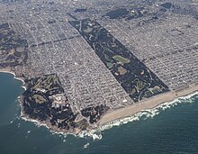
Several of San Francisco's parks and nearly all of its beaches form part of the regional Golden Gate National Recreation Area, one of the most visited units of the National Park system in the United States with over 13 million visitors a year. Among the GGNRA's attractions within the city are Ocean Beach, which runs along the Pacific Ocean shoreline and is frequented by a vibrant surfing community, and Baker Beach, which is located in a cove west of the Golden Gate Bridge, as well as the California Academy of Sciences, a research institute and natural history museum.
The Presidio of San Francisco is the former 18th century Spanish military base, which today is one of the city's largest parks and home to numerous museums and institutions. Also within the Presidio is Crissy Field, a former airfield that was restored to its natural salt marsh ecosystem. The GGNRA also administers Fort Funston, Lands End, Fort Mason, and Alcatraz. The National Park Service separately administers the San Francisco Maritime National Historical Park – a fleet of historic ships and waterfront property around Aquatic Park.[citation needed]


There are more than 220 parks maintained by the San Francisco Recreation & Parks Department.[323] The largest and best-known city park is Golden Gate Park,[324] which stretches from the center of the city west to the Pacific Ocean. Once covered in native grasses and sand dunes, the park was conceived in the 1860s and was created by the extensive planting of thousands of non-native trees and plants. The large park is rich with cultural and natural attractions such as the Conservatory of Flowers, Japanese Tea Garden and San Francisco Botanical Garden.[citation needed]
Lake Merced is a fresh-water lake surrounded by parkland[citation needed] and near the San Francisco Zoo, a city-owned park that houses more than 250 animal species, many of which are endangered.[325] The only park managed by the California State Park system located principally in San Francisco, Candlestick Point was the state's first urban recreation area.[326]
Most of San Francisco's islands are protected as parkland or nature reserves. Alcatraz Island, operated by the National Park Service, is open to the public. The Farallon Islands are protected wildlife refuges. The Seal Rocks are protected as part of Golden Gate National Recreation Area. Red Rock Island is the only privately owned island in San Francisco Bay, but is uninhabited. Yerba Buena Island is largely utilized by the military.
San Francisco is the first city in the U.S. to have a park within a 10-Minute Walk of every resident.[327][328] It also ranks fifth in the U.S. for park access and quality in the 2018 ParkScore ranking of the top 100 park systems across the United States, according to the nonprofit Trust for Public Land.[329]
Government
[edit]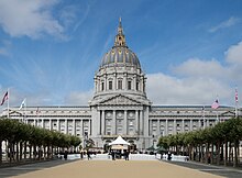
The mayor is also the county executive, and the county Board of Supervisors acts as the city council. The government of San Francisco is a charter city and is constituted of two co-equal branches: the executive branch is headed by the mayor and includes other citywide elected and appointed officials as well as the civil service; the 11-member Board of Supervisors, the legislative branch, is headed by a president and is responsible for passing laws and budgets, though San Franciscans also make use of direct ballot initiatives to pass legislation.[330]
Because of its unique city-county status, the local government is able to exercise jurisdiction over certain property outside city limits. San Francisco International Airport, though located in San Mateo County, is owned and operated by the City and County of San Francisco. San Francisco's largest jail complex (County Jail No. 5) is located in San Mateo County, in an unincorporated area adjacent to San Bruno. San Francisco was also granted a perpetual leasehold over the Hetch Hetchy Valley and watershed in Yosemite National Park by the Raker Act in 1913.[331]

The members of the Board of Supervisors are elected as representatives of specific districts within the city.[332] Upon the death or resignation of the mayor, the President of the Board of Supervisors becomes acting mayor until the full Board elects an interim replacement for the remainder of the term. In 1978, Dianne Feinstein assumed the office following the assassination of George Moscone and was later selected by the board to finish the term.[citation needed] In 2011, Ed Lee was selected by the board to finish the term of Gavin Newsom, who resigned to take office as Lieutenant Governor of California.[333] Lee (who won two elections to remain mayor) was temporarily replaced by San Francisco Board of Supervisors President London Breed after he died on December 12, 2017. Supervisor Mark Farrell was appointed by the Board of Supervisors to finish Lee's term on January 23, 2018.
Most local offices in San Francisco are elected using ranked choice voting.[334]
San Francisco serves as the regional hub for many arms of the federal bureaucracy, including the U.S. Court of Appeals, the Federal Reserve Bank, and the U.S. Mint. Until decommissioning in the early 1990s, the city had major military installations at the Presidio, Treasure Island, and Hunters Point—a legacy still reflected in the annual celebration of Fleet Week. The State of California uses San Francisco as the home of the state supreme court and other state agencies. Foreign governments maintain more than seventy consulates in San Francisco.[335]
The municipal budget for fiscal year 2015–16 was $8.99 billion,[336] and is one of the largest city budgets in the United States.[337] The City of San Francisco spends more per resident than any city other than Washington, D.C., over $10,000 in FY 2015–2016.[337] The city employs around 27,000 workers.[338]
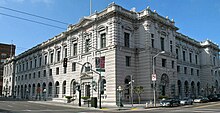
In the California State Senate, San Francisco is in the 11th Senate District, represented by Democrat Scott Wiener. In the California State Assembly, it is split between the 17th Assembly District, represented by Democrat Matt Haney, and the 19th Assembly District, represented by Democrat Phil Ting.[339]
In the United States House of Representatives, San Francisco is split between two congressional districts. Most of the city is in the 11th District, represented by Nancy Pelosi (D–San Francisco). A sliver in the southwest is part of the 15th District represented by Kevin Mullin (D–South San Francisco).[340] Pelosi served as the House Speaker from January 3, 2019, to January 3, 2023, a post she also held from 2007 through 2011. She has also held the post of House Minority Leader, from 2003 to 2007 and 2011 to 2019.
Education
[edit]Colleges and universities
[edit]
The University of California, San Francisco is the sole campus of the University of California system entirely dedicated to graduate education in health and biomedical sciences. It is ranked among the top five medical schools in the United States[341] and operates the UCSF Medical Center, which ranks as the number one hospital in California and the number 5 in the country.[342] UCSF is a major local employer, second in size only to the city and county government.[343][344][345] A 43-acre (17 ha) Mission Bay campus was opened in 2003, complementing its original facility in Parnassus Heights. It contains research space and facilities to foster biotechnology and life sciences entrepreneurship and will double the size of UCSF's research enterprise.[346] All in all, UCSF operates more than 20 facilities across San Francisco.[347]
The University of California College of the Law, San Francisco, founded in Civic Center in 1878, is the oldest law school in California and claims more judges on the state bench than any other institution.[348]San Francisco's two University of California institutions have recently formed an official affiliation in the UCSF/UC Law SF Consortium on Law, Science & Health Policy.[349]

San Francisco State University is part of the California State University system and is located near Lake Merced.[350] The school has approximately 30,000 students and awards undergraduate, master's and doctoral degrees in more than 100 disciplines.[350] The City College of San Francisco, with its main facility in the Ingleside district, is one of the largest two-year community colleges in the country. It has an enrollment of about 100,000 students and offers an extensive continuing education program.[351]

Founded in 1855, the University of San Francisco, a private Jesuit university located on Lone Mountain, is the oldest institution of higher education in San Francisco and one of the oldest universities established west of the Mississippi River.[352] Golden Gate University is a private, nonsectarian university formed in 1901 and located in the Financial District.
With an enrollment of 13,000 students, the Academy of Art University is the largest institute of art and design in the nation.[353] The California College of the Arts, located north of Potrero Hill, has programs in architecture, fine arts, design, and writing.[354] The San Francisco Conservatory of Music, the only independent music school on the West Coast, grants degrees in orchestral instruments, chamber music, composition, and conducting. The San Francisco Art Institute, founded in 1871 and the oldest art school west of the Mississippi,[355] closed in 2022.
The California Culinary Academy, associated with the Le Cordon Bleu program, offers programs in the culinary arts, baking and pastry arts, and hospitality and restaurant management.California Institute of Integral Studies, founded in 1968, offers a variety of graduate programs in its Schools of Professional Psychology & Health, and Consciousness and Transformation.
Primary and secondary schools
[edit]
Public schools are run by the San Francisco Unified School District, which covers the entire city and county,[356] as well as the California State Board of Education for some charter schools. Lowell High School, the oldest public high school in the U.S. west of the Mississippi,[357] and the smaller School of the Arts High School are two of San Francisco's magnet schools at the secondary level. Public school students attend schools based on an assignment system rather than neighborhood proximity.[358]
Just under 30% of the city's school-age population attends one of San Francisco's more than 100 private or parochial schools, compared to a 10% rate nationwide.[359] Nearly 40 of those schools are Catholic schools managed by the Archdiocese of San Francisco.[360]
San Francisco has nearly 300 preschool programs primarily operated by Head Start, San Francisco Unified School District, private for-profit, private non-profit and family child care providers.[361] All four-year-old children living in San Francisco are offered universal access to preschool through the Preschool for All program.[362]
Media
[edit]This section needs additional citations for verification. (January 2022) |

The major daily newspaper in San Francisco is the San Francisco Chronicle, which is currently Northern California's most widely circulated newspaper.[363] The Chronicle is most famous for a former columnist, the late Herb Caen, whose daily musings attracted critical acclaim and represented the "voice of San Francisco." The San Francisco Examiner, once the cornerstone of William Randolph Hearst's media empire and the home of Ambrose Bierce, declined in circulation over the years and now takes the form of a free daily tabloid, under new ownership.[364][365]
Sing Tao Daily claims to be the largest of several Chinese language dailies that serve the Bay Area.[366] SF Weekly is the city's alternative weekly newspaper. San Francisco and 7x7 are major glossy magazines about San Francisco. The national newsmagazine Mother Jones is also based in San Francisco. San Francisco is home to online-only media publications such as SFist, and AsianWeek.

The San Francisco Bay Area is the sixth-largest television market.[367] It is the fourth-largest radio market after that of New York City, Los Angeles, and Chicago.[368] in the U.S.
All major U.S. television networks have affiliates serving the region, with most of them based in the city. CNN, MSNBC, BBC, Russia Today, and CCTV America also have regional news bureaus in San Francisco. Bloomberg West was launched in 2011 from a studio on the Embarcadero and CNBC broadcasts from One Market Plaza since 2015. ESPN uses the local ABC studio for their broadcasting. The regional sports network, Comcast SportsNet Bay Area and its sister station Comcast SportsNet California, are both located in San Francisco. The Pac-12 Network is also based in San Francisco.

Public broadcasting outlets include both a television station and a radio station, both broadcasting under the call letters KQED from a facility near the Potrero Hill neighborhood. KQED-FM is the most-listened-to National Public Radio affiliate in the country.[369]
KUSF is a student-run radio station by college students from the University of San Francisco.[370] Another local broadcaster, KPOO, is an independent, African-American owned and operated noncommercial radio station established in 1971.[371] CNET, founded 1994, and Salon.com, 1995, are based in San Francisco. Sutro Tower is an important broadcast tower located between Mount Sutro and the Twin Peaks, built in 1973 for KTVU, KRON, and KPIX.
Infrastructure
[edit]Transportation
[edit]Public transportation
[edit]
Transit is the most used form of transportation every day in San Francisco. Every weekday, more than 560,000 people travel on Muni's 69 bus routes and more than 140,000 customers ride the Muni Metro light rail system.[372] 32% of San Francisco residents use public transportation for their daily commute to work, ranking it fourth in the United States and first on the West Coast.[373] The San Francisco Municipal Railway, primarily known as Muni, is the primary public transit system of San Francisco. As of 2023, Muni is the eighth-largest transit system in the United States.[374] The system operates a combined light rail and subway system, the Muni Metro, as well as large bus and trolley coach networks.[375] Additionally, it runs a historic streetcar line, which runs on Market Street from Castro Street to Fisherman's Wharf.[375] It also operates the famous cable cars,[375] which have been designated as a National Historic Landmark and are a major tourist attraction.[376]
Bay Area Rapid Transit (BART), a regional Rapid Transit system, connects San Francisco with the East Bay and San Jose through the underwater Transbay Tube. The line, which contains all except the Orange Line, runs under Market Street to Civic Center where it turns south to the Mission District, the southern part of the city, and through northern San Mateo County, to the San Francisco International Airport, and Millbrae.[375]
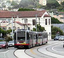
Another commuter rail system, Caltrain, runs from San Francisco along the San Francisco Peninsula to San Jose.[375] Historically, trains operated by Southern Pacific Lines ran from San Francisco to Los Angeles, via Palo Alto and San Jose.
Amtrak Thruway runs a shuttle bus from three locations in San Francisco to its station across the bay in Emeryville.[377] Additionally, BART offers connections to San Francisco from Amtrak's stations in Emeryville, Oakland and Richmond, and Caltrain offers connections in San Jose and Santa Clara. Thruway service also runs south to San Luis Obispo with connection to the Pacific Surfliner.
San Francisco was an early adopter of carsharing in America. The non-profit City CarShare opened in 2001[378] and Zipcar closely followed.[379]
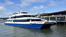
San Francisco Bay Ferry operates from the Ferry Building and Pier 39 to points in Oakland, Alameda, Bay Farm Island, South San Francisco, Richmond, and north to Vallejo in Solano County.[380] The Golden Gate Ferry is the other ferry operator with service between San Francisco and Marin County.[381] SolTrans runs supplemental bus service between the Ferry Building and Vallejo.
To accommodate the large amount of San Francisco citizens who commute to the Silicon Valley daily, employers like Genentech, Google, and Apple have begun to provide private bus transportation for their employees, from San Francisco locations. These buses have quickly become a heated topic of debate within the city, as protesters claim they block bus lanes and delay public buses.[382]
Freeways and roads
[edit]
In 2014, only 41.3% of residents commuted by driving alone or carpooling in private vehicles in San Francisco, a decline from 48.6% in 2000.[383] There are 1,088 miles of streets in San Francisco with 946 miles of these streets being surface streets, and 59 miles of freeways.[383] Due to its unique geography, and the freeway revolts of the late 1950s,[384]Interstate 80 begins at the approach to the Bay Bridge and is the only direct automobile link to the East Bay. U.S. Route 101 connects to the western terminus of Interstate 80 and provides access to the south of the city along San Francisco Bay toward Silicon Valley. Northward, the routing for U.S. 101 uses arterial streets to connect to the Golden Gate Bridge, the only direct automobile link to Marin County and the North Bay.
As part of the retrofitting of the Golden Gate Bridge and installation of a suicide barrier, starting in 2019 the railings on the west side of the pedestrian walkway were replaced with thinner, more flexible slats in order to improve the bridge's aerodynamic tolerance of high wind to 100 mph (161 km/h). Starting in June 2020, reports were received of a loud hum produced by the new railing slats, heard across the city when a strong west wind was blowing.[385]
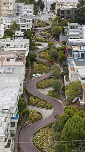
State Route 1 also enters San Francisco from the north via the Golden Gate Bridge and bisects the city as the 19th Avenue arterial thoroughfare, joining with Interstate 280 at the city's southern border. Interstate 280 continues south from San Francisco, and also turns to the east along the southern edge of the city, terminating just south of the Bay Bridge in the South of Market neighborhood. After the 1989 Loma Prieta earthquake, city leaders demolished the Embarcadero Freeway and a portion of the Central Freeway, converting them into street-level boulevards.[384]
State Route 35 enters the city from the south as Skyline Boulevard and terminates at its intersection with Highway 1. State Route 82 enters San Francisco from the south as Mission Street, and terminates shortly thereafter at its junction with 280. The western terminus of the historic transcontinental Lincoln Highway, the first road across America, is in San Francisco's Lincoln Park.
Vision Zero
[edit]In 2014, San Francisco committed to Vision Zero, with the goal of ending all traffic fatalities caused by motor vehicles within the city by 2024.[386] San Francisco's Vision Zero plan calls for investing in engineering, enforcement, and education, and focusing on dangerous intersections. In 2013, 25 people were killed by car and truck drivers while walking and biking in the city and 9 car drivers and passengers were killed in collisions. In 2019, 42 people were killed in traffic collisions in San Francisco.[387]
Airports
[edit]
Though located 13 miles (21 km) south of downtown in unincorporated San Mateo County, San Francisco International Airport (SFO) is under the jurisdiction of the City and County of San Francisco. SFO is a hub for United Airlines[388] and Alaska Airlines.[389] SFO is a major international gateway to Asia and Europe, with the largest international terminal in North America.[390] In 2011, SFO was the eighth-busiest airport in the U.S. and the 22nd-busiest in the world, handling over 40.9 million passengers.[391]
Located in the South Bay, the San Jose International Airport (SJC) is the second-busiest airport in the Bay Area, followed by San Francisco Bay Oakland International Airport, which is a popular, low-cost alternative to SFO. Geographically, San Francisco Bay Oakland Airport is approximately the same distance from downtown San Francisco as SFO, but due to its location across San Francisco Bay, it is greater driving distance from San Francisco.[citation needed]
Cycling and walking
[edit]
Cycling is a popular mode of transportation in San Francisco, with 75,000 residents commuting by bicycle each day.[392] In recent years,[when?] the city has installed better cycling infrastructure such as protected bike lanes and parking racks.[393] Bay Wheels, previously named Bay Area Bike Share at inception, launched in August 2013 with 700 bikes in downtown San Francisco, selected cities in the East Bay, and San Jose. The San Francisco Municipal Transportation Agency and Bay Area Air Quality Management District are responsible for the operation with management provided by Motivate.[394] A major expansion started in 2017, along with a rebranding as Ford GoBike; the company received its current name in 2019.[395]Pedestrian traffic is also widespread. In 2015, Walk Score ranked San Francisco the second-most walkable city in the United States.[396][397][398]
San Francisco has significantly higher rates of pedestrian and bicyclist traffic deaths than the United States on average. In 2013, 21 pedestrians were killed in vehicle collisions, the highest since 2001,[399] which is 2.5 deaths per 100,000 population – 70% higher than the national average of 1.5.[400]
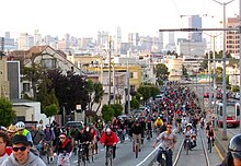
Cycling is becoming increasingly popular in the city. The 2010 Municipal Transportation Agency (MTA) annual bicycle count showed the number of cyclists at 33 locations had increased 58% from the 2006 baseline counts.[401] In 2008, the MTA estimated that about 128,000 trips were made by bicycle each day in the city, or 6% of total trips.[402] As of 2019[update], 2.6% of the city's streets have protected bike lanes, with 28 miles of protected bike lanes in the city.[372] Since 2006, San Francisco has received a Bicycle Friendly Community status of "Gold" from the League of American Bicyclists.[403] In 2022 a measure on the ballot passed to protect JFK drive in Golden Gate Park as a pedestrian and biking space with 59% of voters in favor.[404]
Public safety
[edit]The San Francisco Police Department was founded in 1849.[405] The portions of the Golden Gate National Recreation Area located within the city, including the Presidio and Ocean Beach, are patrolled by the United States Park Police.
The San Francisco Fire Department provides both fire suppression and emergency medical services to the city.[406]
Sister cities
[edit]San Francisco participates in the Sister Cities program.[407] A total of 41 consulates general and 23 honorary consulates have offices in the San Francisco Bay Area.[408]
In January 1980, Mayor Dianne Feinstein signed a sister cities agreement with Shanghai during a visit to China.[409]
Notable residents
[edit]See also
[edit]Notes
[edit]- ^ The land grant was near a boat anchorage around what is today Portsmouth Square.
- ^ Station currently at the United States Mint building[143][self-published source?]
- ^ The coordinates of the station are 37°46′14″N 122°25′37″W / 37.7706°N 122.4269°W. Precipitation, high temperature, low temperature, snow, and snow depth records date from October 1, 1849; June 1, 1874; January 1, 1875; January 1, 1876; and January 1, 1922; respectively.
- ^ Mean monthly maxima and minima (i.e. the expected highest and lowest temperature readings at any point during the year or given month) calculated based on data at said location from 1991 to 2020.
- ^ Those not born in the 50 states or D.C., excluding California, Nevada, Utah, Arizona, New Mexico, and Texas before 1850.
References
[edit]- ^ Jump up to: a b Garling, Caleb (June 30, 2013). "Don't Call It Frisco: The History of San Francisco's Nicknames". The Bold Italic. Retrieved June 18, 2016.
- ^ "San Francisco's Official Songs". Museum of San Francisco. Retrieved June 17, 2020.
- ^ 'Be it resolved: The official song of the City and County of San Francisco is, and shall remain, "San Francisco." Be it further resolved that henceforth: "I Left My Heart in San Francisco" shall be the official ballad.' San Francisco Administrative Code — Steven Short, KALW Public Media, May 10, 2021, "San Francisco's Two Official Songs Or, The Day Tony Bennett Hid In His Hotel" [1]
- ^ Jump up to: a b c O'Day, Edward F. (October 1926). "The Founding of San Francisco". San Francisco Water. Spring Valley Water Authority. Archived from the original on July 27, 2010. Retrieved February 14, 2009.
- ^ "San Francisco: Government". SFGov.org. Archived from the original on March 16, 2012. Retrieved March 8, 2012.
San Francisco was incorporated as a City on April 15th, 1850 by act of the Legislature.
- ^ "Office of the Mayor : Home". City & County of San Francisco. Archived from the original on October 24, 2009. Retrieved July 11, 2018.
- ^ "Statewide Database". UC Regents. Archived from the original on February 1, 2015. Retrieved November 21, 2014.
- ^ "California's 11th Congressional District". GovTrack. Retrieved January 8, 2023.
- ^ "California's 15th Congressional District". GovTrack. Retrieved January 8, 2023.
- ^ "Board of Supervisors". City and County of San Francisco. Retrieved January 28, 2017.
- ^ "Communities of Interest – City". California Citizens Redistricting Commission. Archived from the original on October 23, 2015. Retrieved September 23, 2014.
- ^ "Members Assembly". California State Assembly. Retrieved September 23, 2014.
- ^ "2019 U.S. Gazetteer Files". United States Census Bureau. Retrieved July 1, 2020.
- ^ "San Francisco". Geographic Names Information System. United States Geological Survey, United States Department of the Interior.
- ^ Jump up to: a b "Elevations and Distances in the United States". US Geological Survey. April 29, 2005. Archived from the original on November 9, 2013. Retrieved October 29, 2014.
- ^ Jump up to: a b c "QuickFacts: San Francisco city, California". www.census.gov. United States Census Bureau. Retrieved March 14, 2024.
- ^ "List of 2020 Census Urban Areas". census.gov. United States Census Bureau. Retrieved January 8, 2023.
- ^ "Personal Income by County, Metro, and Other Areas". United States Bureau of Economic Analysis. Retrieved December 8, 2022.
- ^ "Metropolitan and Micropolitan Statistical Areas Population Totals and Components of Change: 2020–2021". United States Census Bureau. February 24, 2022. Retrieved August 13, 2022.
- ^ Massara, Graph (February 20, 2018). "If you're from SF, you're a 'San Franciscan.' But what if you're from Fremont? Berkeley? Livermore?". SFGATE. San Francisco. Retrieved July 29, 2023.
- ^ "Gross Domestic Product by County and Metropolitan Area". fred.stlouisfed.org.
- ^ "ZIP Codes for City of San Francisco, CA". 2010 United States census. 2010. Archived from the original on October 30, 2020. Retrieved March 14, 2021 – via Zip-Codes.com.
- ^ "NPA City Report". North American Numbering Plan Administration. Archived from the original on November 4, 2014. Retrieved November 5, 2014.
- ^ (/ˌsæn frənˈsɪskoʊ/ SAN frən-SISS-koh; Spanish for 'Saint Francis')
- ^ "QuickFacts San Francisco County, California". United States Census Bureau. Retrieved May 17, 2023.
- ^ "GCT-PH1 – Population, Housing Units, Area, and Density: 2010 – County – Census Tract". 2010 United States Census Summary File 1. United States Census Bureau. Archived from the original on February 13, 2020. Retrieved February 8, 2018.
- ^ Jump up to: a b "IPUMS NHGIS | National Historical Geographic Information System". www.nhgis.org. Retrieved December 8, 2023.
- ^ Coy, Owen Cochran (1919). Guide to the County Archives of California. Sacramento, California: California Historical Survey Commission. p. 409.
- ^ Jump up to: a b Montagne, Renée (April 11, 2006). "Remembering the 1906 San Francisco Earthquake". People & Places. NPR. Retrieved June 13, 2008.
- ^ Jump up to: a b "Port of Embarkation Essay—World War II in the San Francisco Bay Area". A National Register of Historic Places Travel Itinerary. US Department of the Interior. August 28, 2007. Archived from the original on June 24, 2011. Retrieved June 22, 2011.
- ^ "Charter of the United Nations | United Nations". Un.org. August 10, 2015. Retrieved December 29, 2016.
- ^ "History of the United Nations". Un.org. United Nations. August 21, 2015. Archived from the original on December 12, 2016. Retrieved December 29, 2016.
- ^ Schlesinger, Stephen (June 19, 2015). "San Francisco – the birthplace of the United Nations". San Francisco Chronicle. Retrieved December 29, 2016.
- ^ "Top 200 Science cities". Nature Index. Retrieved August 17, 2019.
- ^ "The Global Creative Economy Is Big Business". Retrieved August 17, 2019.
- ^ "2022 Best Global Universities Rankings". U.S. News & World Report.
- ^ "Regional Data: GDP and Personal Income". apps.bea.gov. Retrieved June 18, 2022.
- ^ "Metropolitan areas". stats.oecd.org. Retrieved September 17, 2022.
- ^ U.S. Bureau of Labor Statistics (January 1, 1947). "Consumer Price Index for All Urban Consumers: All Items in U.S. City Average". FRED, Federal Reserve Bank of St. Louis. Retrieved June 18, 2022.
- ^ "World Economic Outlook Database, April 2022". IMF. Retrieved June 18, 2022.
- ^ Jump up to: a b "Gross Domestic Product by County, 2022 | U.S. Bureau of Economic Analysis (BEA)". www.bea.gov. Retrieved December 8, 2023.
- ^ "The Global Financial Centres Index 34". www.longfinance.net. Retrieved December 8, 2023.
- ^ Jump up to: a b Morris, J.D. (October 30, 2023). "London Breed vs. the 'doom loop': How will S.F.'s mayor solve her biggest political problem?". San Francisco Chronicle. Retrieved November 5, 2023.
- ^ Wiley, Hannah (May 22, 2024). "All is lost in San Francisco? City loyalists take issue with naysayers. Data may back them up". Los Angeles Times. Retrieved April 4, 2024.
- ^ "America's 10 most visited cities", World Atlas, November 14, 2023
- ^ "San Francisco Travel Association Announces 2022 Results and 2023 Forecast" (Press release). San Francisco Travel. March 21, 2023. Retrieved December 7, 2023.
- ^ "Top U.S. Destinations for International Visitors". The Hotel Price Index. Archived from the original on March 27, 2014. Retrieved April 12, 2014.
- ^ Leins, Casey (April 3, 2019). "The 10 Best Cities for Public Transportation". USNews. Retrieved February 7, 2023.
- ^ "Direct flights from San Francisco (SFO) – FlightConnections". www.flightconnections.com. Retrieved February 7, 2023.
- ^ Jump up to: a b Brinklow, Adam (January 26, 2018). "Is it ever okay to use "San Fran?"". Curbed SF. Retrieved February 17, 2020.
- ^ "Don't Call It 'Frisco': The History of San Francisco's Nicknames". The Bold Italic. December 20, 2019. Retrieved February 17, 2020.
- ^ Gilson, Dave. "Why San Francisco's "Frisco" debate will never, ever die". Mother Jones. Retrieved February 17, 2020.
- ^ Stewart, Suzanne B. (November 2003). "Archaeological Research Issues for the Point Reyes National Seashore – Golden Gate National Recreation Area" (PDF). Sonoma State University – Anthropological Studies Center. Retrieved June 12, 2008.
- ^ "Visitors: San Francisco Historical Information". City and County of San Francisco. n.d. Archived from the original on March 1, 2006. Retrieved June 10, 2008.
- ^ Billiter, Bill (January 1, 1985). "3,000-Year-Old Connection Claimed : Siberia Tie to California Tribes Cited". Los Angeles Times. Retrieved September 25, 2023.
- ^ "Indigenous Peoples of San Mateo County". San Mateo County Office of Education. Retrieved January 18, 2024.
- ^ "The Association of Ramaytush Ohlone". The Association of Ramaytush Ohlone. Retrieved January 18, 2024.
- ^ "The Ramaytush Ohlone – Lessons on stewardship from the ancestral stewards of the Peninsula". Golden Gate National Parks Conservancy. December 4, 2018. Retrieved January 18, 2024.
- ^ Raup, H. F. (1948). "The Delayed Discovery of San Francisco Bay". California Historical Society Quarterly. 27 (4): 293. doi:10.2307/25156125. JSTOR 3816007. Retrieved November 12, 2020.
- ^ Cleary, Brother Guire (January 31, 2003). "Mission Dolores Links San Francisco with its 18th Century Roots – Founded as La Mission San Francisco De Asis by Franciscans, it survived earthquake and fire". Catholic San Francisco. Archived from the original on February 5, 2007. Retrieved March 23, 2007.
- ^ Jump up to: a b Kamiya, Gary (August 23, 2013). "Juana Briones – San Francisco's founding mother". SFGATE.
- ^ Jump up to: a b c "From 1820 to the Gold Rush", at San Francisco Museum.org, accessed 2022.06.03.
- ^ Cf., Richard Henry Dana Jr., Two Years before the Mast (1840).
- ^ The Virtual Museum of the City of San Francisco (July 16, 2004). "From the 1820s to the Gold Rush". The Virtual Museum of the City of San Francisco. Archived from the original on October 22, 2009. Retrieved June 13, 2008.
- ^ "san_francisco_history:san_francisco_census_1842 [SFgenealogy]". www.sfgenealogy.org. Retrieved June 18, 2022.
- ^ Wiley, Peter Booth (2000). National trust guide- San Francisco: America's guide for architecture and history travelers. New York: John Wiley & Sons, Inc. pp. 4–5. ISBN 978-0-471-19120-9. OCLC 44313415.
- ^ Sourdough bread was a staple of western explorers and miners of the 19th century. It became an iconic symbol of San Francisco, and is still a staple of city life today.Tamony, Peter (October 1973). "Sourdough and French Bread". Western Folklore. 32 (4): 265–270. doi:10.2307/1498306. ISSN 0043-373X. JSTOR 1498306.
- ^ "San Francisco's First Brick Building". The Virtual Museum of the City of San Francisco. July 16, 2004. Retrieved June 13, 2008.
- ^ Richards, Rand (1992). Historic San Francisco: A Concise History and Guide. Heritage House. ISBN 978-1-879367-00-5. OCLC 214330849.
- ^ Harris, Ron (November 14, 2005). "Crews Unearth Shipwreck on San Francisco Condo Project". Associated Press. Retrieved September 4, 2006.
- ^ Filion, Ron S. "Buried Ships". SFgenealogy. Retrieved April 19, 2016.
- ^ Report of Committee on Counties, January 4, 1850, revised to 27 counties on February 18, 1850 – Coy, Owen C. (1923). California County Boundaries. Berkeley: California Historical Survey Commission. pp. 1–2.
- ^ Statutes of California and Digests of Measures. J. Winchester. 1856. p. 145.
- ^ Mathews, Joe (April 16, 2023). "Don't bank on California, especially when banks are involved". San Francisco Chronicle.
- ^ Уайли, Питер Бут (2000). Национальный путеводитель по Сан-Франциско: Путеводитель по Америке для путешественников по архитектуре и истории . Нью-Йорк: John Wiley & Sons, Inc., стр. 31–33. ISBN 978-0-471-19120-9 . OCLC 44313415 .
- ^ «Шахтеры пришли в сорок девять, / Шлюхи в пятьдесят один, / И когда они собрались / Родного сына произвели на свет». Уайли, Питер Бут (2000). Национальный путеводитель по Сан-Франциско: Путеводитель по Америке для путешественников по архитектуре и истории . Нью-Йорк: John Wiley & Sons, Inc., стр. 237–238. ISBN 978-0-471-19120-9 . OCLC 44313415 .
- ^ Строительство Тихоокеанской железной дороги было частично (хотя и неохотно) профинансировано выпуском облигаций Тихоокеанской железной дороги города и округа Сан-Франциско в соответствии с положениями «Закона, уполномочивающего Наблюдательный совет города и округа Сан-Франциско брать и подписываться Один миллион долларов в основной капитал компаний Western Pacific Rail Road и Central Pacific Rail Road Company в Калифорнии, а также обеспечить оплату тех же самых и других вопросов, связанных с ними». утвержден 22 апреля 1863 г., с поправками, внесенными § 5 «Соглашенного акта 1864 г.», утвержденного 4 апреля 1864 г. Однако против выпуска облигаций возражали мэр и Наблюдательный совет, и они не были доставлены WPRR и CPRR до 1865 года, после того как в 1864 году Верховным судом штата Калифорния были изданы приказы Мандамуса ( «Народ штата Калифорния об отношениях Центрально-Тихоокеанской железнодорожной компании против Генри П. Куна», мэр Генри М. Хейл, аудитор; и Джозеф С. Паксон, казначей города и округа Сан-Франциско» 25 Cal 635) и 1865 ( «Люди ex rel Центрально-Тихоокеанской железнодорожной компании Калифорнии против Наблюдательного совета города и округа Сан-Франциско и Вильгельма Лоуи, клерка» 27 Cal 655)
- ^ «ИПУМС США» . США.ipums.org . Проверено 18 июня 2022 г.
- ^ «Под тремя флагами» (PDF) . Брошюры о национальной зоне отдыха «Золотые Ворота» . Министерство внутренних дел США. Ноябрь 2004 года . Проверено 22 июня 2011 г.
- ^ Уайли, Питер Бут (2000). Национальный путеводитель по Сан-Франциско: Путеводитель по Америке для путешественников по архитектуре и истории . Нью-Йорк: John Wiley & Sons, Inc., стр. 44–55. ISBN 978-0-471-19120-9 . OCLC 44313415 .
- ^ Калиш, Филип А. (лето 1972 г.). «Черная смерть в китайском квартале: чума и политика в Сан-Франциско 1900–1904». Аризона и Запад . 14 (2): 113–136. JSTOR 40168068 . ПМИД 11614219 .
- ^ «Землетрясение 1906 года: Тушение пожара» . Национальная зона отдыха «Золотые Ворота» . Министерство внутренних дел США. 24 декабря 2003 года . Проверено 13 июня 2008 г.
- ^ «Жертвы и ущерб после землетрясения 1906 года» . Программа по опасности землетрясений – Северная Калифорния . Геологическая служба США. 25 января 2008 года . Проверено 13 июня 2008 г.
- ^ «Землетрясение 1906 года и армия» . Национальная зона отдыха «Золотые Ворота» . Министерство внутренних дел США. 25 августа 2004 года . Проверено 13 июня 2008 г.
- ^ «Джек Лондон пишет о землетрясении и пожаре в Сан-Франциско 1906 года» . Sfmuseum.org. 5 мая 1906 года . Проверено 15 июня 2013 г.
- ^ Уайли, Питер Бут (2000). Национальный путеводитель по Сан-Франциско: Путеводитель по Америке для путешественников по архитектуре и истории . Нью-Йорк: John Wiley & Sons, Inc., стр. 56–62. ISBN 978-0-471-19120-9 . OCLC 44313415 .
- ^ «ШПУР: Наша миссия и история» . Проверено 26 марта 2013 г.
- ^ О'Брайен, Триша (2008). Пасифик-Хайтс и Президио-Хайтс в Сан-Франциско . Сан-Франциско: Издательство Аркадия. п. 7. ISBN 978-0-7385-5980-3 .
- ^ Уайли, Питер Бут (2000). Национальный путеводитель по Сан-Франциско: Путеводитель по Америке для путешественников по архитектуре и истории . Нью-Йорк: John Wiley & Sons, Inc., с. 9. ISBN 978-0-471-19120-9 . OCLC 44313415 .
- ^ «Виртуальный музей города Сан-Франциско - М. М. О'Шонесси, работающий городским инженером» . Проверено 16 марта 2013 г.
- ^ «Банковская Золотая лихорадка Сан-Франциско – 1849» . Виртуальный музей города Сан-Франциско. 24 июня 2004 года. Архивировано из оригинала 9 мая 2008 года . Проверено 13 июня 2008 г.
- ^ «История острова сокровищ» . Тимузей . Проверено 5 августа 2021 г.
- ^ Камия, Гэри (19 августа 2022 г.). «Тёмное прошлое Шарп-парка в Сан-Франциско» . Хроники Сан-Франциско . Архивировано из оригинала 19 августа 2022 года . Проверено 9 июня 2023 г.
- ^ Прайс, Джон (июнь 2001 г.). «Справедливый мир? Мирный договор Сан-Франциско 1951 года в исторической перспективе» . Японский институт политических исследований . Архивировано из оригинала 7 декабря 2020 года . Проверено 8 декабря 2020 г.
- ^ Фанг, Эрик (февраль 1999 г.). «Возвращение к обновлению городов: критика дизайна» . Информационный бюллетень ШПУР . Ассоциация планирования и городских исследований Сан-Франциско. Архивировано из оригинала 11 октября 2009 года . Проверено 3 августа 2009 г.
- ^ Рубин, Джаспер (ноябрь 1999 г.). «Упадок порта – взгляд на трансформацию порта Сан-Франциско» . Информационный бюллетень ШПУР . Проверено 5 января 2013 г.
Окончательный, непреодолимый спад судоходной деятельности Сан-Франциско был ознаменован в 1958 году отправкой первого контейнерного грузового судна из залива Сан-Франциско.
- ^ Терплан, Эгон (7 июня 2010 г.). «Организация экономического роста – новый подход к привлечению и удержанию бизнеса в Сан-Франциско» . Отчет СПУР . Проверено 5 января 2013 г.
В 1960-х и 1970-х годах историческая морская промышленность Сан-Франциско переехала в Окленд. ... Сан-Франциско оставался центром деловых и профессиональных услуг (таких как консалтинг, право, бухгалтерский учет и финансы), а также успешно развивал свой туристический сектор, который стал ведущей местной отраслью.
- ^ Уиллис, Джеймс; Хабиб, Джерри; Бриттан, Джереми (19 апреля 2004 г.). «Анализ данных переписи населения Департамента планирования Сан-Франциско» . Государственный университет Сан-Франциско. Архивировано из оригинала (PPT) 18 июля 2011 года . Проверено 13 июня 2008 г.
- ^ Минтон, Торри (20 сентября 1998 г.). «Гонка сквозь время» . Хроники Сан-Франциско . п. СК-4 . Проверено 11 сентября 2013 г.
- ^ Уайли, Питер Бут (2000). Национальный путеводитель по Сан-Франциско: Путеводитель по Америке для путешественников по архитектуре и истории . Нью-Йорк: John Wiley & Sons, Inc., стр. 240–242. ISBN 978-0-471-19120-9 . OCLC 44313415 .
- ^ «Американский опыт: Лето любви: Описание фильма» . Веб-сайт документального фильма American Experience о Лете любви . ПБС. 14 марта 2007 года. Архивировано из оригинала 5 июня 2008 года . Проверено 17 июня 2008 г.
- ^ «Страх на улицах Сан-Франциско» . Время . 29 апреля 1974 года. Архивировано из оригинала 3 декабря 2008 года . Проверено 28 августа 2006 г.
- ^ «История Сан-Франциско: 1970-е и 1980-е годы: права геев» . Направления: Сан-Франциско . Фроммерс.com. Архивировано из оригинала 18 июля 2001 года . Проверено 17 июня 2008 г.
- ^ «Факты и цифры о пирамидах» . Профиль компании . Страховая и инвестиционная группа «Трансамерика» . Проверено 13 июня 2008 г.
- ^ Уайли, Питер Бут (2000). Национальный путеводитель по Сан-Франциско: Путеводитель по Америке для путешественников по архитектуре и истории . Нью-Йорк: John Wiley & Sons, Inc., стр. 95–96. ISBN 978-0-471-19120-9 . OCLC 44313415 .
- ^ Фэган, Кевин (4 августа 2006 г.). «Старение бездомных в Сан-Франциско на улице / Хронические проблемы со здоровьем растут по мере того, как средний возраст приближается к 50 годам» . Хроники Сан-Франциско . Проверено 6 марта 2012 г.
Результаты подтверждают то, что уже давно подозревали многие социальные работники: произошел «большой взрыв» численности бездомных, когда в середине 1980-х годов были урезаны федеральные жилищные программы, а закрытие психиатрических больниц ударило по домам, и что эта основная группа составляет основную часть бездомных. уличное население.
- ^ «Ассоциация района Хейс-Вэлли» . Ассоциация района Хейс-Вэлли . Проверено 5 августа 2021 г.
- ^ Ньевес, Эвелин (5 ноября 2000 г.). «Миссионский округ борется с лихорадкой доткомов» . Нью-Йорк Таймс . Проверено 5 марта 2012 г.
- ^ Нолте, Карл (2 января 2008 г.). «Высотные здания — это знак времени, меняющего Сан-Франциско» . Хроники Сан-Франциско . Проверено 9 июля 2012 г.
- ^ Иган, Тед (3 апреля 2006 г.). «Город и округ Сан-Франциско: обзор последних экономических показателей Сан-Франциско» (PDF) . Отчет подготовлен для Управления экономического развития и развития рабочей силы мэрии . ИКФ Консалтинг. Архивировано из оригинала (PDF) 1 февраля 2009 г. Проверено 19 июня 2008 г.
Еще одной положительной тенденцией на будущее является высокопредприимчивая, гибкая и инновационная экономика Сан-Франциско... Очень высокая зависимость Сан-Франциско от малого бизнеса и самозанятости типична для других динамичных, быстрорастущих и высокотехнологичных регионов по всей стране.
- ^ Карлтон, Джим; Биндли, Кэтрин (13 августа 2023 г.). «Может ли Сан-Франциско спастись от петли судьбы?» . Уолл Стрит Джорнал . Проверено 5 ноября 2023 г.
- ^ Вейль, Элизабет (10 мая 2023 г.). «Вращаясь в петле гибели Сан-Франциско» . Обузданный . Проверено 5 ноября 2023 г.
Каково жить в городе, который больше не верит, что его проблемы можно решить.
- ^ Уайли, Ханна (16 января 2024 г.). «В Сан-Франциско все потеряно? Сторонники города не согласны с скептиками. Данные могут подтвердить их мнение» . Лос-Анджелес Таймс . Проверено 4 апреля 2024 г.
- ^ Кинг, Джон (3 марта 2024 г.). «Юнион-сквер когда-то была центром Сан-Франциско. Сейчас ее нет на карте» . Хроники Сан-Франциско . Проверено 9 марта 2024 г.
- ^ Ли, Роланд (16 июня 2023 г.). «Вестфилд отказывается от Сан-Франциско, в то время как торговый центр Кремниевой долины имеет рекордные продажи» . Хроники Сан-Франциско . Проверено 9 марта 2024 г.
- ^ «Поиск NPGallery» . Служба национальных парков . Проверено 2 апреля 2023 г.
- ^ Грэм, Том (7 ноября 2004 г.). «Пик опыта» . Хроники Сан-Франциско . Херст Коммуникейшнс. п. ПК-23 . Проверено 13 июня 2008 г.
- ^ Ли, Генри К. (16 января 1997 г.). «Крест горы Дэвидсон, названный группой ориентиром» . Хроники Сан-Франциско . Проверено 17 июня 2008 г.
- ^ Смит, Чарльз (15 апреля 2006 г.). «Чему Сан-Франциско не научился после землетрясения 2006 года» . Хроники Сан-Франциско . Проверено 30 июня 2008 г.
- ^ Селна, Роберт (29 июня 2008 г.). «Лидеры Сан-Франциско игнорируют риск землетрясения в слабых зданиях» . Хроники Сан-Франциско . п. А-1 . Проверено 30 июня 2008 г.
- ^ Прогноз землетрясения в Калифорнии - UCERF3 - Информационный бюллетень Геологической службы США (нетехнический), март 2015 г. Прогнозирует риск землетрясений на 30 лет в Калифорнии, прогноз землетрясений в Калифорнии .
- ^ «Повреждения от сжижения в районе Марина во время землетрясения в Лома-Приета 1989 года» (PDF) . Калифорнийская геологическая служба . Проверено 17 июня 2008 г.
- ^ Бауме, Мэтт (14 апреля 2010 г.). «Приманка ручьев, спрятанных под улицами Сан-Франциско» . Стритсблог Сан-Франциско . Проверено 31 января 2013 г.
- ^ Официальный сайт китайского квартала Сан-Франциско . Sanfranciscochinatown.com. Проверено 16 февраля 2012 г.
- ^ Изображение инаковости: изображения китайского квартала Сан-Франциско . College Street Journal (11 октября 2002 г.). Проверено 16 февраля 2012 г.
- ^ Бэкон, Дэниел: Прогулка по тропе Берберийского побережья, 2-е изд., стр. 52–53, Quicksilver Press, 1997.
- ^ «Китайский квартал / Грант-авеню» . Архивировано из оригинала 15 июня 2011 года . Проверено 31 августа 2010 г. . Дни Сан-Франциско
- ^ Дайнин, Дж. К. (9 декабря 2015 г.). «Супервайзеры SF на арене OK Warriors в заливе Мишн» . СФГЕЙТ . Херст Коммуникейшнз, Инк . Проверено 8 февраля 2016 г.
- ^ «Дом хиппи Хейт-Эшбери: сохранение контркультуры Сан-Франциско 1960-х годов | Национальный фонд сохранения исторического наследия» . saveplaces.org . Проверено 5 августа 2021 г.
- ^ «Хайт» . Хроника Сан-Франциско . Проверено 3 августа 2009 г.
- ^ Епископ Кэтрин (13 октября 1988 г.). «Журнал Хейт-Эшбери; Любовь и ненависть сохраняются в районе бывших хиппи» . Нью-Йорк Таймс . Проверено 3 августа 2009 г.
- ^ «Марина» . Путеводитель по окрестностям SFGate Сан-Франциско . 27 октября 2011 года . Проверено 20 августа 2013 г.
- ^ Морган, Бенджамин (директор) (2007). «Качество жизни (сайт фильма)» . История миссионерского округа . Проверено 25 июля 2010 г.
- ^ «Кастро» . Хроника Сан-Франциско . Проверено 3 августа 2009 г.
- ^ Чоу, Эндрю (22 марта 2002 г.). «Унылая явка АПА на первых собраниях по изменению избирательных округов». Азиатская неделя .
- ^ Климат Сан-Франциско: Повествовательное описание Метеослужбы Золотых Ворот. Проверено 5 сентября 2006 г.
- ^ «Климат Сан-Франциско: средняя температура, погода по месяцам, температура воды в Сан-Франциско — Climate-Data.org» . ru.climate-data.org . Проверено 5 августа 2021 г.
- ^ Осборн, Лиз. «Самые крутые города США летом» . Погодные экстримы . Связь текущих результатов. Архивировано из оригинала 24 июля 2010 года . Проверено 25 июля 2010 г.
- ^ Гиллиам, Гарольд (июль – сентябрь 2002 г.). «Прорываясь сквозь туман: демистификация летнего зрелища» . Природа залива .
- ^ Перейти обратно: а б с д и ж г час «Климатические данные NOAA» . Национальное управление океанических и атмосферных исследований . Проверено 6 февраля 2019 г.
- ^ Климат Сан-Франциско: Снегопад Метеорологические службы Золотых Ворот. Проверено 3 декабря 2006 г.
- ^ Хартлауб, Питер (29 ноября 2012 г.). «Ужасная метель: Снегопад в Сан-Франциско 1976 года» . Хроники Сан-Франциско . Проверено 1 февраля 2013 г.
- ^ Дадли, Эндрю (1 мая 2014 г.). «Секретно потрясающе: метеостанция Лоуэр-Хейт» . линия капюшона .
- ^ Руберштейн, Стив; Азимов, Нанетт; Лайонс, Дженна (1 сентября 2017 г.). «В Сан-Франциско температура достигает 106 градусов – это побивает рекорд всех времен» . Хроники Сан-Франциско . Проверено 2 сентября 2017 г.
- ^ «NOWData для прогнозного бюро Сан-Франциско, Калифорния» . НОАА . Проверено 26 июля 2022 г.
- ^ «Миссия Сан-Франциско Долор, Калифорния (047772) Период рекордных общих климатических данных – температура» . Западный региональный климатический центр . Институт исследования пустынь . 2010. Архивировано из оригинала 13 мая 2011 года . Проверено 25 июля 2010 г. ( Главная страница )
- ^ Тума, Дрю; Дидион, Тим (10 августа 2021 г.). «В докладе ООН по климату основное внимание уделяется угрозе повышения уровня моря в заливе Сан-Франциско» . ABC7 Сан-Франциско . Проверено 31 января 2022 г.
- ^ Центр сельскохозяйственных исследований, Климатическая группа PRISM, Университет штата Орегон. «Карта зон устойчивости растений Министерства сельского хозяйства США» . Министерство сельского хозяйства США . Архивировано из оригинала 27 февраля 2014 года . Проверено 24 февраля 2014 г.
- ^ «Калифорнийская интерактивная карта зон устойчивости растений Министерства сельского хозяйства США» . Проверено 19 декабря 2016 г.
- ^ «Сводка ежемесячных норм за 1991–2020 годы» . Национальное управление океанических и атмосферных исследований . Проверено 5 мая 2021 г.
- ^ «Название станции: CA SAN FRANCISCO DWTN» . Национальное управление океанических и атмосферных исследований . Проверено 18 марта 2014 г.
- ^ «Сан-Франциско / Миссия Долорес, Калифорния Нормальные климатические условия 1961–1990» . Национальное управление океанических и атмосферных исследований . Проверено 23 апреля 2013 г.
- ^ «Праздничная погода в Сан-Франциско» . Метеорологическое бюро . Проверено 18 сентября 2017 г.
- ^ «Климат и ежемесячный прогноз погоды в Сан-Франциско, Калифорния» . Проверено 16 августа 2022 г.
- ^ Бротон, Джек М. (1994). «Снижение эффективности добывания пищи млекопитающими в позднем голоцене, залив Сан-Франциско, Калифорния» . Журнал антропологической археологии . 13 (4): 371–401. дои : 10.1006/jaar.1994.1019 . Проверено 27 мая 2020 г.
- ^ Маккроссин, М. (1982). «Палеоэкологические выводы из фаунистического анализа CA-SFr-07». Журнал Калифорнии и антропологии Большого бассейна . 4 : 138–141.
- ^ Болтон, Герберт Юджин (1930). Калифорнийские экспедиции Анзы . Том. I. Аванпост Империи. Беркли, Калифорния: Издательство Калифорнийского университета. п. 393.
- ^ Дана младший, Ричард Генри (1840). Два года до мачты. Личное повествование . Нью-Йорк: Харпер и братья. п. 270. ИСБН 9781441405401 .
- ^ «Краткие факты: округ Сан-Франциско, Калифорния» . Бюро переписи населения США. Архивировано из оригинала 16 января 2019 года . Проверено 5 апреля 2019 г.
- ^ «Историческая статистика переписи населения по расам, с 1790 по 1990 год, и по латиноамериканскому происхождению, с 1970 по 1990 год, для крупных городов и других городских населенных пунктов в Соединенных Штатах» . Бюро переписи населения США. Архивировано из оригинала 12 августа 2012 года . Проверено 18 декабря 2011 г.
- ^ Перейти обратно: а б с «QT-P3 - Раса и латиноамериканское или латиноамериканское происхождение: 2010» . Сводный файл переписи населения США 2010 года 1 . Бюро переписи населения США. Архивировано из оригинала 12 февраля 2020 года . Проверено 11 июля 2011 г.
- ^ «Обучение и образование/ПЭТ» . Филиппино-американская ассоциация сотрудников правоохранительных органов. Архивировано из оригинала 16 января 2013 года . Проверено 28 апреля 2012 г.
- ^ Перейти обратно: а б «Интерактив: Составление карты переписи» . Вашингтон Пост . Архивировано из оригинала 13 мая 2011 года . Проверено 9 февраля 2012 г.
- ^ «Перепись 2020 года: по мере роста Сан-Франциско этнический состав его районов менялся. Вот как» . 27 сентября 2021 г.
- ^ Перейти обратно: а б Герт Занд, Рене (14 февраля 2018 г.). «Огромная молодая еврейская община Сан-Франциско растет, но не имеет членства, говорится в исследовании» . Таймс Израиля. Времена Израиля . Проверено 13 июля 2022 г.
- ^ «ПУТЕВОДИТЕЛЬ ПО ЕВРЕЙСКОМУ НАСЛЕДИЮ В САН-ФРАНЦИСКО» . Туристическая ассоциация Сан-Франциско . СФ Путешествие . Проверено 13 июля 2022 г.
- ^ Швецкая, Катя. «Филлмор: еврейский квартал 1920-х годов» . Нашел СФ . Проверено 13 июля 2022 г.
- ^ Перейти обратно: а б «ИПУМС США» . США.ipums.org . Проверено 25 февраля 2022 г.
- ^ Бюро переписи населения США. «Раса и этническая принадлежность в Соединенных Штатах: перепись 2010 года и перепись 2020 года» . Census.gov . Проверено 25 февраля 2022 г.
- ^ Основные мегаполисы США различаются по своим религиозным профилям , Pew Research Center.
- ^ «Меняющийся религиозный ландшафт Америки» . Исследовательский центр Пью : Религия и общественная жизнь. 12 мая 2015 г.
- ^ «Чунг: китайский «крестьянский» диалект искуплен – The Mercury News» . 22 декабря 2007 года . Проверено 19 декабря 2016 г.
- ^ «Расшифровка китайского квартала: на каком языке все говорят?» . Проверено 19 декабря 2016 г.
- ^ «Округ Сан-Франциско, Калифорния» . Ассоциация современного языка . Проверено 25 апреля 2023 г.
- ^ Перейти обратно: а б с д и Памук, Айше (осень 2017 г.). «География кластеров иммигрантов в городах мира: пример Сан-Франциско». Международный журнал городских и региональных исследований . 28 (2): 287–307. дои : 10.1111/j.0309-1317.2004.00520.x .
- ^ «Путеводитель по самым дорогим районам Сан-Франциско» . www.california.com .
- ^ «Интеллектуальный потенциал крупнейших городов Америки» . Bizjournals.com (данные интерпретированы из переписи населения США). 2006. Архивировано из оригинала 1 июля 2006 года . Проверено 5 августа 2010 г.
- ^ Винтер, Майкл (9 июня 2010 г.). «Новые показатели делают Сан-Франциско самым умным городом США» . США сегодня . Проверено 5 августа 2010 г.
- ^ Гейтс, Гэри (октябрь 2006 г.). «Однополые пары и геи, лесбиянки и бисексуалы: новые оценки исследования американского сообщества» (PDF) . Институт Уильямса, юридический факультет Калифорнийского университета в Лос-Анджелесе. Архивировано из оригинала (PDF) 2 июля 2007 г. Проверено 10 июля 2008 г.
- ^ «Семьи геев и лесбиянок в Соединенных Штатах: домохозяйства, состоящие из однополых партнеров, не состоящих в браке» (PDF) . Кампания по правам человека. Архивировано из оригинала (PDF) 13 апреля 2008 г. Проверено 26 августа 2006 г.
- ^ «Средний доход домохозяйства (в долларах с поправкой на инфляцию в 2003 году) (уровень места)» . Бюро переписи населения США. 22 августа 2007 года. Архивировано из оригинала 9 декабря 2004 года . Проверено 23 июня 2009 г.
- ^ Перейти обратно: а б «Краткие факты: округ Сан-Франциско, Калифорния» . Бюро переписи населения США. Архивировано из оригинала 13 июля 2011 года . Проверено 11 июля 2011 г.
- ^ Санкин, Аарон (9 марта 2012 г.). «Семьи бегут из Сан-Франциско: в городе самый низкий процент детей среди всех крупных городов США» . ХаффПост . Проверено 8 августа 2018 г.
- ^ Хендрикс, Майкл (21 ноября 2018 г.). «Одиночество молодых американцев готовит почву для Дня друзей» . Вашингтон Пост . Проверено 21 ноября 2018 г.
- ^ «Экономическая характеристика» . Оценки опроса американского сообщества за 2005–2009 годы за 5 лет – основные моменты профиля данных . Бюро переписи населения США. 2007. Архивировано из оригинала 11 февраля 2020 года . Проверено 9 января 2015 г.
- ^ «Деинституционализация: психиатрический «Титаник» » . ПБС. Архивировано из оригинала 20 июля 2014 года . Проверено 9 августа 2014 г.
- ^ «Программа Сан-Франциско борется с бездомностью с помощью инноваций» . ПБС . 5 апреля 2005 года. Архивировано из оригинала 10 января 2012 года . Проверено 6 сентября 2007 г.
- ^ Пратт, Тимоти (12 августа 2006 г.). «Критики говорят, что региональный план не решит проблему» . Лас-Вегас Сан . Проверено 30 августа 2006 г.
- ^ Каркамо, Синди; Мэзер, Кейт; Смит, Дакота (15 ноября 2016 г.). «Принятие Трампом суровых мер в отношении нелегальной иммиграции оставляет без ответа многое для таких городов-убежищ, как Лос-Анджелес», — Los Angeles Times . Проверено 5 декабря 2019 г.
- ^ Бьюкенен, Вятт (14 ноября 2007 г.). «Надзиратели Сан-Франциско утверждают удостоверения личности для жителей» . Хроники Сан-Франциско . Проверено 17 апреля 2019 г.
- ^ Сондерс, Дебра (9 августа 2015 г.). «Лето мочи и бездомных наркоманов в Сан-Франциско» . Ворота Сан-Франциско . Проверено 17 марта 2017 г.
- ^ Перейти обратно: а б «Отчет о подсчете бездомных в Сан-Франциско за 2019 год» (PDF) . 2019.
- ^ Перейти обратно: а б Графф, Эми (24 января 2018 г.). «Эксперт ООН по бездомности в Сан-Франциско: «Я не мог не быть в полном шоке » . СФГЕЙТ . Проверено 6 августа 2018 г.
- ^ «Предлагаемый бюджет мэра города и округа Сан-Франциско, Калифорния на 2020–2021 и 2021–2022 годы» (PDF) . Архивировано из оригинала (PDF) 21 октября 2023 года.
- ^ «Сан-Франциско вводит санкции против лагерей для бездомных, которых когда-то избегали» . Новости АВС . 23 мая 2020 г.
- ^ Завери, Пааял (5 апреля 2023 г.). «Уровень убийств в Сан-Франциско невелик по сравнению с другими крупными городами, но убийство основателя высоких технологий Боба Ли показывает, что это еще не все» . Бизнес-инсайдер . Инсайдер Инк.
- ^ Бульва, Демиан (5 января 2012 г.). «В трудные времена количество убийств в спецназе достигло исторического минимума» . Хроники Сан-Франциско . Проверено 29 июля 2013 г.
- ^ «Уровень преступности и статистика Сан-Франциско» . Соседский разведчик . Проверено 29 июля 2013 г.
- ^ «Вырезка» . НайденСФ . Проверено 29 июля 2013 г.
- ^ Хо, Вивиан (4 июля 2015 г.). «Уровень убийств в районе залива остается низким» . Хроники Сан-Франциско .
- ↑ Бодли, Майкл (4 января 2017 г.). «Полицейские Сан-Франциско говорят, что за последние два убийства в 2016 году они зафиксировали два ареста». СФГейт. Проверено 17 января 2017 г.
- ^ Шабан, Бигад; Кампос, Роберт; Кэрролл, Джереми; Вильярреал, Марк (17 ноября 2021 г.). «Переломный момент: в Сан-Франциско самый высокий уровень взломов автомобилей по сравнению с Атлантой, округ Колумбия, Далласом, Лос-Анджелес» . nbcbayarea.com . Проверено 12 июля 2022 г.
- ^ Найт, Хизер (14 августа 2018 г.). «Это не шутка — Сан-Франциско формирует Poop Patrol, чтобы содержать тротуары в чистоте» . Хроники Сан-Франциско . Проверено 15 августа 2018 г.
- ^ Вопросы, поднятые после того, как подозреваемый в десятках преступлений на почве ненависти в отношении азиатских предприятий Сан-Франциско оказался вне тюрьмы , CBS News, 26 января 2022 г., Архив
- ^ «Уличная банда Ла Мара Сальватруча» . Еженедельник Сан-Франциско . Архивировано из оригинала 26 июля 2013 года . Проверено 29 июля 2013 г.
- ^ Бульва, Демиан (27 мая 2005 г.). «САН-ФРАНЦИСКО / Угроза банды Суреньо в районе залива растет / Квартира вдовы находится в самом сердце территории района Миссии группы» . Хроники Сан-Франциско . Проверено 29 марта 2014 г.
- ^ Самаха, Альберт (26 сентября 2012 г.). «Без крип: неприязнь научной фантастики к франшизам распространяется и на уличные банды – Страница 1 – Новости – Сан-Франциско» . Еженедельник Сан-Франциско . Проверено 29 июля 2013 г.
- ^ Робертс, Крис (декабрь 2015 г.). «Марио Вудс и судебные запреты на банды» . Еженедельник Сан-Франциско . Архивировано из оригинала 18 сентября 2016 года . Проверено 5 сентября 2016 г.
- ^ Мэри Спикуцца (1 августа 2007 г.). «Вход дракона» . Еженедельник Сан-Франциско . Архивировано из оригинала 19 сентября 2016 года . Проверено 5 сентября 2016 г.
- ^ Грешлер, Гейб (23 апреля 2024 г.). «Преступность в Сан-Франциско падает. Попробуйте сказать это избирателям» . Стандарт Сан-Франциско . Проверено 25 июля 2024 г.
{{cite news}}: CS1 maint: статус URL ( ссылка ) - ^ Арройо, Ной (10 июня 2022 г.). «Центр Сан-Франциско на грани: все хуже, чем кажется» . Хроники Сан-Франциско . Проверено 8 сентября 2023 г.
- ^ Перейти обратно: а б «Занятость в отрасли и рабочая сила – в среднем за год по округу Сан-Франциско» . Департамент развития занятости Калифорнии. 2016.
- ^ Бюро экономического анализа США (1 января 2001 г.). «Общий реальный валовой внутренний продукт для Сан-Франциско-Окленд-Хейворд, Калифорния (MSA)» . ФРЕД, Федеральный резервный банк Сент-Луиса . Проверено 5 января 2021 г.
- ^ Перейти обратно: а б «ВВП по округам, метро и другим регионам» . Bea.gov . Проверено 27 марта 2021 г.
- ^ «Личный доход по округам, метро и другим регионам | Бюро экономического анализа США (BEA)» . Bea.gov . Проверено 5 января 2021 г.
- ^ Перейти обратно: а б Проект федеральных писателей Управления прогресса работ Северной Калифорнии (2011). Сан-Франциско в 1930-е годы: Путеводитель WPA по городу у залива . Издательство Калифорнийского университета. п. 114. ИСБН 978-0-520-26880-7 .
- ^ «Сан-Франциско: Экономика» . City-Data.com . Проверено 15 июня 2008 г.
- ^ «Фортуна 500» . Журнал Fortune, Time Inc. 2013. Архивировано из оригинала 27 марта 2014 года . Проверено 6 апреля 2014 г.
- ^ «Мир по версии GaWC 2012» . Группа и сеть исследований глобализации и мировых городов (GaWC) . Университет Лафборо . Проверено 25 января 2014 г.
- ^ «Индекс мировых финансовых центров 21» (PDF) . Китайский институт развития. Март 2017 г. Архивировано из оригинала (PDF) 18 сентября 2018 г. . Проверено 4 сентября 2018 г.
- ^ Перейти обратно: а б Уотерс, Роб (15 мая 2009 г.). «Рабочие места в области биотехнологий растут по мере диверсификации экономики Сан-Франциско» . Блумберг . Архивировано из оригинала 23 октября 2015 года.
- ^ Варбург, Дженнифер (27 февраля 2014 г.). «Прогнозирование экономического благополучия Сан-Франциско» . ШПУР . Проверено 6 апреля 2014 г.
- ^ Селна, Роберт (15 мая 2008 г.). «Новые рабочие места и дома стимулируют рост населения Сан-Франциско в Хроники Сан-Франциско . п. Б-1 . Получено июня , 14
- ^ Гарланд, Расс (27 февраля 2014 г.). «Поскольку инвестиции в районе залива смещаются на север, Institutional Venture Partners открывает офис в Сан-Франциско» . Уолл Стрит Джорнал . Проверено 11 апреля 2014 г.
- ^ Флорида, Ричард (31 марта 2014 г.). «Город стартапов: городской сдвиг в венчурном капитале и высоких технологиях» . Институт процветания Мартина, Школа менеджмента Ротмана, Университет Торонто. Архивировано из оригинала 5 апреля 2014 года . Проверено 6 апреля 2014 г.
- ^ Флорида, Ричард (8 сентября 2012 г.). «Городской технологический бум Сан-Франциско» . Хроники Сан-Франциско . Проверено 6 апреля 2014 г.
- ^ Янг, Эрик (4 мая 2010 г.). «SF продлевает освобождение от налога на заработную плату в биотехнологиях» . Сан-Франциско Бизнес Таймс . Проверено 6 апреля 2014 г.
- ^ «Науки о жизни и биотехнологии» (Пресс-релиз). Центр экономического развития Сан-Франциско . Проверено 6 апреля 2014 г.
- ^ «Мэр Ли объявляет о создании нового биотехнологического инкубатора в Мишн-Бэй» . Офис мэра города и округа Сан-Франциско. 10 сентября 2013 года . Проверено 6 апреля 2014 г.
- ^ Кинг, Джон (3 марта 2024 г.). «Юнион-сквер когда-то была центром Сан-Франциско. Сейчас ее нет на карте» . Хроники Сан-Франциско . Проверено 3 марта 2024 г.
- ^ Уилсон, Роб (ноябрь 2008 г.). «Призрачный город: Сан-Франциско как город Тихоокеанского региона и контркультурный контадо». Межазиатские культурные исследования . 9 (4): 583–597. дои : 10.1080/14649370802386503 . S2CID 145302676 .
- ^ Догерти, Конор; Гольдберг, Эмма (17 декабря 2022 г.). «Что будет дальше с самым пустым центром города в Америке? Технические работники все еще дома. Ресторан за 17 долларов расширяется и в пригородах. Так что же осталось в Сан-Франциско?» . Нью-Йорк Таймс . Проверено 17 декабря 2022 г.
В любую неделю в Сан-Франциско офисные здания загружены примерно на 40 процентов от уровня, который был до пандемии.
- ^ Д'Инноченцио, Энн; Хар, Джени (16 июля 2023 г.). «Диверсифицируйте или умрите: центр Сан-Франциско — тревожный сигнал для других городов» . АП Новости . Проверено 10 октября 2023 г.
- ^ Боулз, Нелли (8 июня 2022 г.). «КАК САН-ФРАНЦИСКО СТАЛ НЕУДАЧНЫМ ГОРОДОМ» . Атлантика . Проверено 27 июня 2023 г.
- ^ Труонг, Кевин (24 октября 2022 г.). «Как развивается Твиттер, так и происходит возрождение района, который он помог преобразовать» . Стандарт Сан-Франциско . Проверено 10 октября 2023 г.
- ^ «Комплексный годовой финансовый отчет города и округа Сан-Франциско, Калифорния, за год, закончившийся 30 июня 2018 г.» (PDF) . п. 243 . Проверено 10 мая 2019 г.
- ^ Ли, Роланд (14 ноября 2018 г.). «Salesforce разместит еще 1500 сотрудников во второй башне Transbay» . Хроники Сан-Франциско . Проверено 10 мая 2019 г.
- ^ Тан, Олдрич М. (12 апреля 2006 г.). «Сан-Франциско — город-ворота для иммигрантов и технологий Кремниевой долины» . Fogcityjournal.com . Проверено 15 июня 2008 г.
- ^ Перейти обратно: а б Иган, Тед (3 апреля 2006 г.). «Обзор последних экономических показателей Сан-Франциско – краткое изложение» (PDF) . ИКФ Консалтинг. Архивировано из оригинала (PDF) 10 июля 2007 года . Проверено 14 июня 2008 г.
- ^ Саид, Кэролайн (29 ноября 2005 г.). «Мейн-стрит борется с Цепной улицей» . Хроники Сан-Франциско . Проверено 27 августа 2006 г.
- ^ Хеттер, Катя (21 марта 2004 г.). «Руководители согласовали ограничения на расширение сети магазинов» . Хроники Сан-Франциско . Проверено 19 января 2007 г.
- ^ «Предложение G: ограничения на магазины розничной торговли Formula, город Сан-Франциско» . smartvoter.org . Проверено 19 января 2007 г.
- ^ «Невада» . Чертежная кнопка . Проверено 21 октября 2016 г.
- ^ Перейти обратно: а б Фрохо, Рене (14 февраля 2014 г.). «Сделано в Сан-Франциско: возвращение производства» . Проверено 6 апреля 2014 г.
- ^ «Средняя цена дома в округе» . Национальная ассоциация риэлторов . 2022. Архивировано из оригинала 20 апреля 2022 года . Проверено 26 октября 2022 г.
- ^ Аранья, Роли (осень 2017 г.). «Глобальные« городские американские горки »? Изменения в связях мировой городской сети, 2000–2004 годы» . Региональные исследования . 42 : 1–16. дои : 10.1080/00343400601145202 . S2CID 154611136 .
- ^ Айзенпресс, Кара (28 апреля 2023 г.). «Нью-Йорк как никогда близок к тому, чтобы превзойти регион Залива по технологиям» . Крэйн Коммуникейшнс . Проверено 29 мая 2023 г.
- ^ Айзенпресс, Кара (22 мая 2023 г.). «Впервые Манхэттен обогнал Сан-Франциско по количеству новых стартапов на ранней стадии» . Крэйн Коммуникейшнс . Проверено 14 октября 2023 г.
- ^ Иган (3 апреля 2006 г.). «Город и округ Сан-Франциско: обзор последних экономических показателей Сан-Франциско» (PDF) . Отчет подготовлен для Управления экономического развития и развития рабочей силы мэрии . ИКФ Консалтинг. Архивировано из оригинала (PDF) 1 февраля 2009 г. Проверено 6 декабря 2017 г.
- ^ Флинн, Райан (3 сентября 2010 г.). «Туризм в Сан-Франциско набирает обороты, но расходы остаются на прежнем уровне» . Хроники Сан-Франциско . п. Д-1. Архивировано из оригинала 24 мая 2017 года . Проверено 4 февраля 2012 г.
- ^ «Иностранные гости посетят города США в 2015–2016 гг.» (PDF) . Национальный офис путешествий и туризма . Управление международной торговли Министерства торговли США. 2016. Архивировано из оригинала (PDF) 22 февраля 2018 года . Проверено 22 февраля 2018 г.
- ^ «Сан-Франциско Travel сообщает о рекордном туризме в 2016 году» . Туристическая ассоциация Сан-Франциско (пресс-релиз). 18 января 2017 года . Проверено 8 декабря 2017 г.
- ^ «Статистика индустрии посетителей Сан-Франциско» . Туристическая ассоциация Сан-Франциско. 2013 . Проверено 5 апреля 2014 г.
- ^ «Остров Алькатрас: исследуйте сенсационный Сан-Франциско: TravelChannel.com» . Канал путешествий . Проверено 9 ноября 2016 г.
- ^ «20 лучших достопримечательностей Сан-Франциско» . Сан-Франциско Путешествие . Проверено 9 ноября 2016 г.
- ^ Маклин, Тесса (16 августа 2021 г.). «В Сан-Франциско почти 200 крошечных улиц. Это моя любимая» . СФГЕЙТ . Проверено 26 октября 2022 г.
- ^ «SFPort - Проект круизного терминала Джеймса Р. Хермана на пирсе 27» . Проверено 16 марта 2013 г.
- ^ Хартман, Честер (2002). Город на продажу: Преобразование Сан-Франциско . Издательство Калифорнийского университета. п. 24.
- ^ Бойд, Нан Аламилла (2011). «Район Кастро в Сан-Франциско: от освобождения геев к туристическому направлению». Журнал туризма и культурных изменений . 9 (3): 237–248. дои : 10.1080/14766825.2011.620122 . S2CID 143916613 .
- ^ «Самые пешеходные города США» Walkscore.com . Проверено 23 августа 2022 г.
- ^ Вах, Бонни (3 октября 2003 г.). «Город тумана восстает из фанка» . США сегодня . Архивировано из оригинала 15 мая 2006 года . Проверено 4 сентября 2006 г.
- ^ «Какой Кастро?» . СФГейт. Архивировано из оригинала 4 сентября 2014 года . Проверено 30 июля 2014 г.
- ^ Шварцер, Мишель (июль 2001 г.). «Сан-Франциско в цифрах: планирование после переписи 2000 года» . Информационный бюллетень ШПУР . Ассоциация планирования и городских исследований Сан-Франциско. Архивировано из оригинала 11 февраля 2005 года . Проверено 25 июля 2010 г.
- ^ Садови, Маура Уэббер (12 апреля 2006 г.). «Цены на жилье в Сан-Франциско остаются одними из самых высоких в США», The Wall Street Journal . Архивировано из оригинала 1 марта 2007 года . Проверено 14 июня 2008 г.
- ^ «Средний семейный доход (в долларах с поправкой на инфляцию в 2003 году)» . Опрос американского сообщества . Бюро переписи населения США. 22 августа 2007. Архивировано из оригинала 13 октября 2004 года . Проверено 14 июня 2008 г.
- ^ Хоун, Карлин (март 2007 г.). «Возможно, вам так не кажется, но ваши шансы на хорошую жизнь становятся все лучше. Вот почему» . Журнал Сан-Франциско . Современная роскошь. Архивировано из оригинала 24 февраля 2007 года . Проверено 14 июня 2008 г.
- ^ " «Всемирный рейтинг городов по качеству жизни за 2014 год – исследование Mercer» . Мерсер Консалтинг . Февраль 2014 года . Проверено 4 ноября 2015 г.
- ^ Хендрикс, Тихе (22 июня 2006 г.). «Богатый город, бедный город: кварталы среднего класса исчезают из городов страны, остаются только районы с высокими и низкими доходами, говорится в новом исследовании» . Хроники Сан-Франциско . п. А-1 . Проверено 14 июня 2008 г.
- ^ Анна Мари Эрверт (2 июня 2015 г.). «Средняя арендная плата в Сан-Франциско достигает смехотворных 4225 долларов» . На блоке .
- ^ «Жарко в городе». The Economist , 2 апреля 2016 г.: 71. печать.
- ^ Лейп, Дэйв (4 июня 2008 г.). «Атлас президентских выборов в США Дэйва Лейпа» . Дэйв Лейп . Проверено 14 июня 2008 г.
- ^ Закон о реформе может ограничить набор студентов в здоровый Сан-Франциско до 60% - California Healthline . Californiahealthline.org. Проверено 16 февраля 2012 г.
- ^ Локк, Лаура А. (23 июня 2006 г.). «Последние инновации Сан-Франциско: всеобщее здравоохранение» . Время . ТАЙМ США, ООО. Архивировано из оригинала 3 июля 2006 года . Проверено 21 июля 2021 г.
- ^ «Расходы участников». Архивировано 27 марта 2010 г. на Wayback Machine , healthsanfrancisco.org. Проверено 10 апреля 2010 г.
- ^ «Универсальный план здравоохранения, одобренный в Сан-Франциско» , Insurance Journal , 20 июля 2006 г.
- ^ Эти иголки, разбросанные по улицам? Город их раздал , San Francisco Chronicle, 8 мая 2018 г.
- ↑ Бесплатные шприцы Сан-Франциско засоряют улицы , CBS, Сан-Франциско, 10 мая 2018 г.
- ^ Джонсон, Сидней (5 июля 2022 г.). «Город второго шанса: план Сан-Франциско по уменьшению кризиса передозировки» . Ревизор Сан-Франциско . Архивировано из оригинала 19 марта 2022 года . Проверено 7 декабря 2022 г.
- ^ «О Сьерра-клубе» . Проверено 26 марта 2013 г.
- ^ «Друзья городского леса – О нас» . Проверено 26 марта 2013 г.
- ^ «Программа жилищного обслуживания «Рекология» . Проверено 26 марта 2013 г.
- ^ «СФПУК ГоСоларСФ» . Проверено 26 марта 2013 г.
- ^ «О чистой энергии НФ» . Архивировано из оригинала 20 февраля 2015 года . Проверено 21 февраля 2015 г.
- ^ «Смазочный цикл SFPUC» . Проверено 26 марта 2013 г.
- ^ «Мэр Ньюсом хвалит SFPUC за одобрение нового проекта солнечной энергии на пять мегаватт на водохранилище Сансет» (пресс-релиз). Офис мэра Сан-Франциско. 12 декабря 2008 года . Проверено 29 сентября 2009 г.
- ^ Глейзер, Ли (7 декабря 2010 г.). «Сан-Франциско получает новый способ получения возобновляемой энергии» . Новости КГО ABC7. Архивировано из оригинала 10 апреля 2014 года . Проверено 13 апреля 2013 г.
- ^ Анг, Алексис (12 июля 2022 г.). «Объяснение культур: как Сан-Франциско стал мировой Меккой геев» . Стажер-путешественник . Сингапур: The Travel Intern Pte. ООО . Проверено 28 июля 2024 г.
- ^ Ньюпорт, Фрэнк; Гейтс, Гэри Дж. (20 марта 2015 г.). «Агломерация Сан-Франциско занимает первое место по проценту ЛГБТ» . Гэллап . Гэллап, Инк.
- ^ «Гордость Сан-Франциско» . Март 2023. Архивировано из оригинала 26 марта 2023 года . Проверено 26 марта 2023 г.
- ^ «Победы в судах стимулируют гей-парады» . США сегодня .
- ^ Рабаби, Майкл (2018). Фуд-корт на Фолсом-стрит . Лос-Анджелес, Калифорния: Delancey Street Press. п. 64. ИСБН 978-0692183731 .
- ^ «Дешевое свидание – что делать?» . CNN . [ постоянная мертвая ссылка ]
- ^ «Опера Сан-Франциско | Классический голос Сан-Франциско» . www.sfcv.org . Проверено 29 декабря 2021 г.
- ^ "SFJAZZ.org | О проекте" . www.sfjazz.org . Проверено 29 декабря 2021 г.
- ^ «САН-ФРАНЦИСКО САУНД» . www.shsu.edu . Проверено 5 августа 2021 г.
- ^ «Вспоминая самое знаковое место классического рока на западном побережье» . 24 мая 2018 года . Проверено 2 апреля 2023 г.
- ^ «Сцена слева: история театра Сан-Франциско» . Район залива 7х7 . 9 ноября 2012 г.
- ^ Джонс, Чад. «Тонис у залива» . Журнал Theatre Bay Area , май/июнь 2014 г.
- ↑ Сандерс, Эдриенн, «SF поднимает занавес для бродвейских хитов», San Francisco Business Times , 3 апреля 2005 г. [2]
- ^ Джонс, Чад. «Тонис у залива». Журнал Theater Bay Area , май/июнь 2014 г. [3]
- ^ «Корпоративное спонсорство – зачем спонсировать» . Музей современного искусства Сан-Франциско. Архивировано из оригинала 29 декабря 2007 года . Проверено 14 июня 2008 г.
- ^ «Наше расширение · SFMOMA» . СФМОМА .
- ^ «Музеи Сан-Франциско» . СанФранциско.нет . Проверено 15 ноября 2015 г.
- ^ «Институт современного искусства CCA Wattis» . Wattis.org . Проверено 20 февраля 2024 г.
- ^ «Федеральные налоговые льготы для заброшенных месторождений: SBC Park» (PDF) . Браунфилдс . Агентство по охране окружающей среды США. Май 2005 г. Архивировано из оригинала (PDF) 21 сентября 2006 г. . Проверено 15 июня 2008 г.
- ^ Сперлинг, Берт (25 октября 2012 г.). «Лучшие бейсбольные города» . Проверено 29 октября 2012 г.
- ^ Матье, Филипп; Росс, Эндрю (9 ноября 2006 г.). «САН-ФРАНЦИСКО / 49ers говорят, что переезжают в Санта-Клару» . Хроники Сан-Франциско . Проверено 28 марта 2012 г.
- ^ «Мэр Сан-Франциско: 49ers почти уверены в переезде в Санта-Клару» . ПрессДемократ.com. 6 декабря 2011 года . Проверено 28 марта 2012 г.
- ^ «За именем – Уорриорз | ОФИЦИАЛЬНЫЙ САЙТ ГОЛДЕН Стейт Уорриорз» . Нба.com . Проверено 9 ноября 2016 г.
- ^ Колизей, Oracle Arena и округ Окленд-Аламеда. «Голден Стэйт Уорриорз | Оракл Арена и Колизей округа Окленд-Аламеда» . Oraclearena.com . Архивировано из оригинала 9 декабря 2016 года . Проверено 9 ноября 2016 г.
- ^ «Голден Стэйт Уорриорз» выиграли чемпионат НБА 2022 года: «Уорриорз» завоевали седьмой титул в истории франшизы» . НБА . 16 июня 2022 г. . Проверено 17 июня 2022 г.
- ^ «Легкая атлетика и спорт - Бюллетень государственного университета Сан-Франциско, 2013–2014» . Sfsu.edu . Проверено 9 ноября 2016 г.
- ^ «О нас – История» . ING Bay в Брейкерс . Группа ИНГ. 11 марта 2008 года. Архивировано из оригинала 24 ноября 2012 года . Проверено 25 июля 2010 г.
- ^ Бульва, Демиан (27 июля 2009 г.). «Марафон в Сан-Франциско: 26,2 мили приятной боли» . Пресс-релиз . Проверено 7 сентября 2010 г.
- ^ «Информационный бюллетень» (PDF) . Пресс-релиз . Accenture Побег из Алькатраса Триатлон. 23 мая 2008 г. Архивировано из оригинала (PDF) 25 января 2009 г. . Проверено 19 января 2009 г.
- ^ Кот, Джон (2010). «Сан-Франциско выбран местом проведения Кубка Америки» . Хроники Сан-Франциско . Проверено 11 сентября 2013 г.
- ^ «Объекты велосипедной сети» . Путешествие на работу и ресурсы . Управление муниципального транспорта Сан-Франциско. 12 мая 2008 года. Архивировано из оригинала 4 апреля 2013 года . Проверено 15 июня 2008 г.
- ^ Хюблер, Эрик (2008). «Самые приспособленные и самые толстые города Америки» . Мужской фитнес . Архивировано из оригинала 11 октября 2008 года . Проверено 15 июня 2008 г.
- ^ Лаутенбах, Бретт (16 октября 2017 г.). «Киберспорт встряхнет Северную Калифорнию: встретите шок в Сан-Франциско» . www.businesswire.com . Проверено 23 апреля 2021 г.
- ^ Сэмплы, Рэйчел (29 сентября 2019 г.). «Сан-Франциско Шок стал чемпионом Overwatch League 2019 года» . Точка Киберспорт . Проверено 23 апреля 2021 г.
- ^ Амин, Джастин (10 октября 2020 г.). «Сан-Франциско Шок» — чемпионы Overwatch League 2020 года . Сеть Esportz . Архивировано из оригинала 7 июня 2023 года . Проверено 23 апреля 2021 г.
- ^ Бринклоу, Адам (22 августа 2018 г.). «Парк Золотые Ворота занимает третье место по популярности в США» . Обузданный СФ . Проверено 13 ноября 2019 г.
- ^ «Список объектов» . Департамент отдыха и парков Сан-Франциско . Город и округ Сан-Франциско. Архивировано из оригинала 16 августа 2010 года . Проверено 25 июля 2010 г.
- ^ «Самые посещаемые городские парки» (PDF) . Центр совершенствования городских парков . Фонд государственных земель. 11 октября 2007 г. Архивировано из оригинала (PDF) 18 марта 2009 г. . Проверено 17 июня 2008 г.
- ^ «Что посмотреть в зоопарке» . Зоопарк Сан-Франциско. Архивировано из оригинала 19 июля 2011 года . Проверено 14 июня 2008 г.
- ^ «Точка свечи SRA» . Департамент парков штата Калифорния . Проверено 27 января 2009 г.
- ^ «Первый город Сан-Франциско в стране с парком в 10 минутах ходьбы от каждого дома» . Хроники Сан-Франциско . Проверено 23 мая 2018 г.
- ^ «В Сан-Франциско все живут в 10 минутах ходьбы от парка» . CBS SF Bay Area . 16 мая 2017 г. Проверено 23 мая 2018 г.
- ^ «ПаркСкор» . Parkscore.tpl.org . Архивировано из оригинала 24 мая 2018 года . Проверено 23 мая 2018 г.
- ^ «Попечительский совет – есть ли в Сан-Франциско городской совет?» . Архивировано из оригинала 26 августа 2008 года . Проверено 28 октября 2015 г.
- ^ «Попечительский совет – есть ли в Сан-Франциско городской совет?» . SFGov SF311 . Архивировано из оригинала 29 ноября 2010 года . Проверено 16 июня 2008 г.
- ^ «Информация попечительского совета округа» . Город и округ Сан-Франциско, Наблюдательный совет. Архивировано из оригинала 14 июля 2007 года . Проверено 29 января 2006 г.
- ^ Коте, Джон (11 января 2011 г.). «Эд Ли становится первым китайско-американским мэром города» . Хроника Сан-Франциско . Архивировано из оригинала 12 октября 2013 года.
- ^ «Рейтинговое голосование | Сан-Франциско» . sf.gov . Проверено 13 сентября 2023 г.
- ^ «Иностранные консульства в США, 2007 г.» (PDF) . Государственный департамент США . Проверено 12 декабря 2008 г.
- ^ «Постановление о бюджете и ассигнованиях от 21 июля 2015 г. - финансовые годы, заканчивающиеся 30 июня 2016 г. и 30 июня 2017 г.» (PDF) . Контроллер СФ . 21 июля 2015 года . Проверено 16 апреля 2020 г.
- ^ Перейти обратно: а б «Анализ расходов в крупнейших городах Америки – Ballotpedia» . Проверено 16 марта 2017 г.
- ^ Гордон, Рэйчел (26 апреля 2010 г.). «Каждый третий сотрудник Сан-Франциско заработал 100 000 долларов» . Хроники Сан-Франциско . Проверено 7 марта 2012 г.
- ^ «Сообщества по интересам — округ» . Комиссия по перераспределению граждан Калифорнии. Архивировано из оригинала 23 октября 2015 года . Проверено 28 сентября 2014 г.
- ^ «12-й избирательный округ Калифорнии — представители и карта округа» . Гражданский Импульс, ООО . Проверено 12 марта 2013 г.
- ^ «Лучшие аспирантуры Америки: лучшие медицинские школы» . Новости США и мировой отчет . 2010. Архивировано из оригинала 21 апреля 2010 года . Проверено 25 июля 2010 г.
- ^ Комароу, Эйвери (14 июля 2010 г.). «Лучшие больницы 2011–2012 гг.: Доска почета» . Новости США и мировой отчет . Проверено 25 июля 2010 г.
- ^ «Деловая информация Сан-Франциско: крупнейшие работодатели Сан-Франциско» . Книга списков San Francisco Business Times, 2007 г. Центр экономического развития Сан-Франциско. Архивировано из оригинала (Microsoft Word) 17 августа 2007 года . Проверено 9 июня 2008 г.
- ^ Лейти, Рон (11 июня 2010 г.). «UCSF приносит экономике 6 миллиардов долларов» . Сан-Франциско Бизнес Таймс . Архивировано из оригинала 16 июня 2010 года . Проверено 26 июля 2010 г.
- ^ «Занятость и экономический стимул» . Отчет об экономическом воздействии 2010 года . Калифорнийский университет, Сан-Франциско . Архивировано из оригинала 1 июля 2010 года . Проверено 26 июля 2010 г.
- ^ Раввен, Уоллес (22 июля 2003 г.). «Новый кампус UCSF Mission Bay: крупнейшее в стране расширение биомедицинского университета» . Калифорнийский университет, Сан-Франциско . Проверено 9 июня 2008 г.
- ^ UCSF (2015). «Локации» . Проверено 21 февраля 2015 г.
- ^ «Краткие факты о Гастингсе» . Юридический колледж Гастингса Калифорнийского университета . Проверено 30 августа 2006 г.
- ^ «Консорциум UCSF/UC Hastings» . Юридический колледж Гастингса Калифорнийского университета. Архивировано из оригинала 26 апреля 2013 года . Проверено 2 июня 2013 г.
- ^ Перейти обратно: а б «Факты о штате Сан-Франциско за 2008–2009 годы» (PDF) . СФГУ . Проверено 7 марта 2009 г.
- ^ «Информационный бюллетень Городского колледжа Сан-Франциско» . Городской колледж Сан-Франциско. Апрель 2008 г. Архивировано из оригинала (PDF) 2 декабря 2008 г. . Проверено 16 июня 2008 г.
- ^ «Сборник фактов и альманах Университета Сан-Франциско, 2007 г.» (PDF) . Университет Сан-Франциско. 31 декабря 2007 г. Архивировано из оригинала (PDF) 24 июня 2008 г. . Проверено 25 июля 2010 г.
- ^ «Кто мы» . Академия художеств университета. 2008 год . Проверено 18 февраля 2009 г.
- ^ «Кампусы Окленда и Сан-Франциско» . Калифорнийский колледж искусств. 2012 . Проверено 23 мая 2012 г.
- ^ Поехали: путешествие по США . Макмиллан. 2007. с. 489. ИСБН 9780312361822 . Проверено 18 февраля 2009 г.
- ^ «ПЕРЕПИСЬ 2020 ГОДА – СПРАВОЧНАЯ КАРТА ШКОЛЬНОГО ОКРУГА: округ Сан-Франциско, Калифорния» (PDF) . Бюро переписи населения США . Проверено 22 июля 2022 г. – Текстовый список
- ^ «Старейшая государственная средняя школа к западу от Миссисипи» . О Лоуэлле: История Лоуэлла . Объединенный школьный округ Сан-Франциско. 22 февраля 2002 года. Архивировано из оригинала 14 апреля 2002 года . Проверено 25 июля 2010 г.
- ^ Такер, Джилл (10 июня 2015 г.). «Совет Сан-Франциско придерживается системы школьных заданий» . СФГЕЙТ . Херст Коммуникейшнс, Инк.
- ^ Найт, Хизер (31 мая 2006 г.). «Многие неохотно выбрали частные школы» . Хроники Сан-Франциско . п. А-1 . Проверено 16 июня 2008 г.
- ^ «Справочник школ, август 2010 г.» (PDF) . Римско-католическая архиепископия Сан-Франциско. Август 2010 г. Архивировано из оригинала (PDF) 27 ноября 2010 г. . Проверено 23 января 2011 г.
- ^ «Дошкольные учреждения Сан-Франциско» . Винни . Проверено 18 мая 2017 г.
- ^ «Дошкольное учреждение для всех» . Управление раннего ухода и образования Сан-Франциско. Архивировано из оригинала 24 мая 2017 года . Проверено 18 мая 2017 г.
- ^ «200 крупнейших газет по величине тиража» . Аудиторское бюро тиражей. 31 марта 2007. Архивировано из оригинала 13 августа 2007 года . Проверено 14 июня 2008 г.
- ^ Розенберг, Скотт (21 марта 2000 г.). «Ревизор Сан-Франциско, 1887–2000» . Салон . Архивировано из оригинала 27 июня 2009 года . Проверено 15 июня 2008 г.
- ^ Нолте, Карл (22 ноября 2000 г.). «Сотрудники экспертизы заканчивают эпоху слезами, рассказы редакции новостей» . Хроники Сан-Франциско . п. А-1 . Проверено 15 июня 2008 г.
- ^ Хуа, Ванесса (3 августа 2004 г.). «Газетная война в районе залива: Мин Пао становится шестой ежедневной газетой на китайском языке» . Хроники Сан-Франциско . п. Б-1 . Проверено 14 июня 2008 г.
- ^ «Оценки рынка местного телевидения» . 22 сентября 2007 года. Архивировано из оригинала (XLS) 27 сентября 2007 года . Проверено 15 июня 2008 г.
- ^ «Рейтинг радиорынка Arbitron: весна 2008 г.» . Арбитрон. 16 апреля 2008 года. Архивировано из оригинала 10 июля 2007 года . Проверено 14 июня 2008 г.
- ^ «30 крупнейших подписчиков общественного радио – Арбитрон, зима 2004 г.» (PDF) . Консорциум радиоисследований . Арбитрон Медиа Исследования. 17 июня 2004 г. Архивировано из оригинала (PDF) 23 апреля 2005 г. . Проверено 14 июня 2008 г.
- ^ «О – КУСФ» . www.kusf.org . Проверено 2 апреля 2023 г.
- ^ «КПОО – О нас» . kpoo.com .
- ^ Перейти обратно: а б «Годовой отчет SFMTA за 2019 год» (PDF) . Sfmta.com . Проверено 16 апреля 2021 г.
- ^ Кристи, Лес (29 июня 2007 г.). «Жители Нью-Йорка — лучшие пользователи общественного транспорта» . CNNMoney.com . Проверено 20 августа 2008 г.
- ^ «Крупнейшие транзитные агентства США по пассажиропотокам» . Статистика . Проверено 1 января 2024 г.
- ^ Перейти обратно: а б с д и «Путешественник по заливу: информация о транспорте» . Сан-Франциско Кроникл Инк . Март 2007 г. Архивировано из оригинала 30 августа 2008 г. Проверено 16 июня 2008 г.
- ^ «Отчет о канатных дорогах Сан-Франциско» (PDF) . Сан-Франциско прекрасен. Май 2007 года . Проверено 16 июня 2008 г.
- ^ «Стейшн Эмеривилл (EMY)» . Амтрак . Проверено 25 июля 2010 г.
- ^ «Миссия City CarShare Out» . Проверено 26 марта 2013 г.
- ^ «Zipcar Наша миссия» . Проверено 26 марта 2013 г.
- ^ «Паром из залива Сан-Франциско» . Проверено 26 марта 2013 г.
- ^ «Паром Золотые Ворота» . Проверено 26 марта 2013 г.
- ^ «Автобус Google заблокирован во время протеста против джентрификации в Сан-Франциско» . Рейтер . 9 декабря 2016 года . Проверено 9 ноября 2016 г.
- ^ Перейти обратно: а б «Информационный бюллетень о транспортировке SFMTA» (PDF) . 2015.
- ^ Перейти обратно: а б Гордон, Рэйчел (8 сентября 2005 г.). «Бульвар мечты, премьера» . Хроники Сан-Франциско . п. Б-1 . Проверено 16 июня 2008 г.
- ^ Тинг, Эрик (6 июня 2020 г.). «Почему мост Золотые Ворота издавал странные звуки из-за ветра в пятницу» . Хроники Сан-Франциско . Архивировано из оригинала 5 июля 2020 года . Проверено 5 июля 2020 г.
- ^ Квонг, Джессика (19 февраля 2014 г.). «Сан-Франциско делает шаг вперед в сфере образования пешеходов, велосипедистов и водителей» . Ревизор Сан-Франциско . Архивировано из оригинала 26 февраля 2014 года . Проверено 26 февраля 2014 г.
- ^ «Отчет о смертности в результате дорожно-транспортных происшествий на конец 2019 года» (PDF) . 2019.
- ^ Янг, Эрик (2 апреля 2004 г.). «Пакт не дает «Юнайтед» улететь» . Сан-Франциско Бизнес Таймс . Проверено 16 июня 2008 г.
- ^ «Alaska Air Group завершает приобретение Virgin America и становится пятой по величине авиакомпанией США» . 14 декабря 2016 года . Проверено 24 февраля 2019 г.
- ^ «Информационный бюллетень: Международный терминал» (PDF) . Международный аэропорт Сан-Франциско. Май 2007 г. Архивировано из оригинала (PDF) 7 августа 2013 г. . Проверено 16 июня 2008 г.
- ^ «Предварительные данные о мировом пассажиропотоке в 2011 г. (Таблица 2 – Общий пассажиропоток в 2011 г.)» (PDF) . Международный совет аэропортов. 27 марта 2012 года . Проверено 22 апреля 2012 г.
- ^ «Отчет о подсчете велосипедов за 2011 год» (PDF) . СФМТА . Город Сан-Франциско. Декабрь 2011 года . Проверено 17 мая 2012 г.
- ^ Отчет о состоянии велосипедного движения в Сан-Франциско за 2012 год (PDF) (Отчет). Агентство муниципального транспорта Сан-Франциско. 2012. с. 2 . Проверено 24 октября 2015 г.
- ^ Бялик, Аарон (29 июня 2017 г.). «Запуск Ford GoBike, предоставляющий возможность совместного использования велосипедов в новых районах Сан-Франциско» . SFMTA: Агентство муниципального транспорта . Проверено 30 апреля 2018 г.
- ^ «Хватай электровелосипед и вперед» . Форд Гобайк . Архивировано из оригинала 17 декабря 2017 года . Проверено 30 апреля 2018 г.
- ^ Саид, Кэролин (20 июля 2011 г.). «Сан-Франциско и Окленд вошли в десятку самых пешеходных городов США» . Хроники Сан-Франциско . Проверено 20 июля 2011 г.
- ^ «10 самых пешеходных городов США» . МаркетВотч. 2011 . Проверено 20 июля 2011 г.
- ^ «Оценка ходьбы — самые проходимые города 2015 года – @Redfin» . 7 апреля 2015 года . Проверено 25 сентября 2015 г.
- ^ Сабатини, Джошуа (16 января 2014 г.). «Ли демонстрирует усилия по обеспечению безопасности пешеходов» . Ревизор СФ . Проверено 19 января 2014 г.
- ^ «Факты безопасности дорожного движения, автомобильные аварии в 2012 году: обзор» (PDF) . Национальное управление безопасности дорожного движения . Проверено 19 января 2014 г.
- ^ «Отчет о подсчете велосипедов в городе Сан-Франциско за 2010 год» (PDF) . Агентство муниципального транспорта Сан-Франциско, 2010, с. 3 .
- ^ «Отчет о состоянии велосипедного движения в Сан-Франциско за 2008 год» (PDF) . Агентство муниципального транспорта Сан-Франциско. 2008. с. 9 . Проверено 1 октября 2014 г.
- ^ «Америка, дружественная к велосипедистам, 2010» (PDF) . Американский велосипедист : 17. 2010 г. Проверено 24 октября 2015 г.
- ^ Кано, Рикардо (9 ноября 2022 г.). «JFK Drive останется без автомобилей после того, как избиратели Сан-Франциско отклонят предложение I и примут предложение J» . Хроники Сан-Франциско . Проверено 5 декабря 2022 г.
- ^ «История СФПД» . Департамент полиции Сан-Франциско. Архивировано из оригинала 1 марта 2017 года . Проверено 28 февраля 2017 г.
- ^ «Ответ пожарной комиссии на отчет большого жюри» . Пожарная служба Сан-Франциско. Архивировано из оригинала 13 февраля 2017 года . Проверено 12 февраля 2017 г.
- ^ «Города-побратимы Сан-Франциско» . Проверено 1 февраля 2017 г. [ мертвая ссылка ]
- ^ «РЕЕСТР ИНОСТРАННЫХ КОНСУЛЬСТВ В САН-ФРАНЦИСКО» (PDF) . Архивировано из оригинала (PDF) 23 ноября 2014 года . Проверено 11 марта 2013 г.
- ^ Лэмптон, Дэвид М. (2024). Живые отношения США и Китая: от холодной войны к холодной войне . Лэнхэм, доктор медицины: Роуман и Литтлфилд . п. 200. ИСБН 978-1-5381-8725-8 .
Библиография
[ редактировать ]- Де Лаперуз, Жан Франсуа; Ямане, Линда Гонсалвес; Марголин, Малькольм (1989). Жизнь в калифорнийской миссии: Монтерей в 1786 году: Журналы Жана Франсуа Де Лаперуза . Книги расцвета . ISBN 978-0-930588-39-7 . OCLC 20368802 .
- Хансен, Глэдис (1995). Альманах Сан-Франциско: Все, что вы хотите знать о городе . Книги летописи. ISBN 978-0-8118-0841-5 . ОСЛК 30702907 .
- Лондон, Джек (5 мая 1906 г.). «Рассказ очевидца Джека Лондона». Кольерс, Национальный еженедельник .
- Ричардс, Рэнд (1991). Исторический Сан-Франциско: краткая история и путеводитель . Дом Наследия. ISBN 978-1-879367-00-5 . OCLC 214330849 .
- Унгаретти, Лорри (2005). Район Ричмонд Сан-Франциско . Издательство Аркадия. ISBN 978-0-7385-3053-6 . OCLC 62249656 .
- Уайли, Питер Бут (2000). Национальный путеводитель по Сан-Франциско: Американский путеводитель для путешественников по архитектуре и истории . Джон Уайли и сыновья, Inc. ISBN 978-0-471-19120-9 . OCLC 44313415 .
Дальнейшее чтение
[ редактировать ]- Эсбери, Хьюберт (1989). Берберийское побережье: неофициальная история преступного мира Сан-Франциско . Дорсет Пресс. ISBN 978-0-88029-428-7 . ОСЛК 22719465 .
- Бронсон, Уильям (2006). Земля сотряслась, небо сгорело . Книги летописи. ISBN 978-0-8118-5047-6 . OCLC 65223734 .
- Кэссиди, Стивен (1987). Перекрытие ворот . Квадратные книги. ISBN 978-0-916290-36-8 . OCLC 15229396 .
- Диллон, Ричард Х. (1998). High Steel: строительство мостов через залив Сан-Франциско . Небесные искусства (переиздание). ISBN 978-0-88029-428-7 . ОСЛК 22719465 .
- Элдридж, Зоет Скиннер (1912). Начало Сан-Франциско: от экспедиции Анзы 1774 года до городского устава от 15 апреля 1850 года (PDF) . Нью-Йорк: Компания Джона К. Рэнкина.
- Ферлингетти, Лоуренс (1980). Литературный Сан-Франциско: иллюстрированная история от зарождения до наших дней . Харпер и Роу. ISBN 978-0-06-250325-1 . OCLC 6683688 .
- Хартман, Честер (2002). Город на продажу: трансформация Сан-Франциско . Издательство Калифорнийского университета. ISBN 978-0-520-08605-0 . OCLC 48579085 .
- Хеллер, Натан. Bay Watched - Как новая предпринимательская культура Сан-Франциско меняет страну (статья) (октябрь 2013 г.). Житель Нью-Йорка
- Холлидей, Дж. С. (1999). Погоня за богатством: золотая лихорадка и создание Калифорнии . Издательство Калифорнийского университета. ISBN 978-0-520-21402-6 . OCLC 37545551 .
- Лотчин, Роджер В. (1997). Сан-Франциско, 1846–1856: От Гамлета до города . Издательство Университета Иллинойса. ISBN 978-0-252-06631-3 . ОСЛК 35650934 .
- Марголин, Малькольм (1981). Путь Олона: жизнь индейцев в районе залива Сан-Франциско и Монтерей . Книги Хейди. ISBN 978-0-930588-01-4 . OCLC 4628382 .
- Мопен, Армистед (1978). Сказки города . Харпер Коллинз. ISBN 978-0-06-096404-7 . OCLC 29847673 .
- Солнит, Ребекка. Бесконечный город: Атлас Сан-Франциско (Калифорнийский университет Press, 2010). 144 стр. ISBN 978-0-520-26250-8 ; онлайн-обзор
- Томас, Гордон и Уиттс, Макс Морган (1971). в Сан-Франциско Землетрясение Штейн и Дэй. ISBN 978-0-8128-1360-9 . OCLC 154735 .
- Уоткинс, Джеймс Ф. (январь 1870 г.). «Сан-Франциско» . Оверленд Ежемесячник . Том. 4, нет. 1. Сан-Франциско: А. Роман и Ко, стр. 9–23.
- Уинфилд, PH, Хартия Сан-Франциско (двухнедельный обзор, том 157–58: 2 (1945), стр. 69–75).
Внешние ссылки
[ редактировать ]Статьи, касающиеся города и округа Сан-Франциско |
|---|


- San Francisco
- 1776 заведений в Альте Калифорния
- 1850 заведений в Калифорнии
- округа Калифорнии
- Города в районе залива Сан-Франциско
- Объединенные города-округа
- Округа в районе залива Сан-Франциско
- Места округа в Калифорнии
- Торговые посты компании Гудзонова залива
- Объединенные города и поселки Калифорнии
- Населенные прибрежные места Калифорнии
- Населенные пункты, основанные в 1776 году.
- Портовые города в Калифорнии
- Поселения испанской миссии в Северной Америке
- Округа большинства меньшинств в Калифорнии