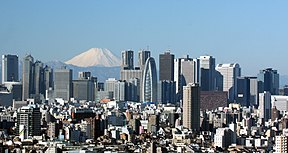
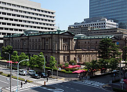
Номинальная валовая внутренняя добыча в Токио составила 113,7 триллиона иен или 1,04 триллиона долларов США в 2021 финансовом году, что составило 20,7% от общего экономического производства страны, что превращается в 8,07 миллиона иен или 73 820 долларов США на душу населения. [ 16 ] Включая район Большого Токио, Токио является второй по величине столичной экономикой в мире после Нью-Йорка , а валовой митрополитный продукт 2022 года оценивается в 2,08 трлн долларов США. [ 17 ] Хотя статус Токио как ведущего глобального финансового центра снизился за счет потерянных десятилетий с 1990 -х годов, когда Токийская фондовая биржа была крупнейшей в мире, с рыночной капитализацией примерно в 1,5 раза больше, чем в NYSE , [ 18 ] Город по -прежнему является крупным финансовым центром, и TSE остается среди пяти лучших в мире основных фондовых бирж . [ 19 ] Токио классифицируется как город Альфа+ Сеть Глобализации и мировых исследований . Город также признан одним из самых пригодных для жизни в мире; Он занял четвертое место в мире в 2021 году в глобальном рейтинге . [ 20 ] Токио также считался самым безопасным городом в мире в нескольких международных исследованиях. [ 21 ] [ 22 ] [ 23 ] [ 24 ] [ 25 ]
Tokyo was originally known as Edo (江戸), a kanji compound of 江 (e, "cove, inlet") and 戸 (to, "entrance, gate, door").[26] The name, which can be translated as "estuary", is a reference to the original settlement's location at the meeting of the Sumida River and Tokyo Bay. During the Meiji Restoration in 1868, the name of the city was changed to Tokyo (東京, from 東tō "east", and 京kyō "capital"), when it became the new imperial capital,[27] in line with the East Asian tradition of including the word capital (京) in the name of the capital city (for example, Kyoto (京都), Keijō (京城), Beijing (北京), Nanjing (南京), and Xijing (西京)).[26] During the early Meiji period, the city was sometimes called "Tōkei", an alternative pronunciation for the same characters representing "Tokyo", making it a kanji homograph. Some surviving official English documents use the spelling "Tokei";[28] however, this pronunciation is now obsolete.[29]
Tokyo was originally a village called Edo, part of the old Musashi Province. Edo was first fortified by the Edo clan in the late twelfth century. In 1457, Ōta Dōkan built Edo Castle to defend the region from the Chiba clan. After Dōkan was assassinated in 1486, the castle and the area came to be possessed by several feudal lords. In 1590, Tokugawa Ieyasu was granted the Kantō region by Toyotomi Hideyoshi and moved there from his ancestral land of Mikawa Province. He greatly expanded the castle, which was said to have been abandoned and in tatters when he moved there, and ruled the region from there. When he became shōgun, the de facto ruler of the country, in 1603, the whole country came to be ruled from Edo. While the Tokugawa shogunate ruled the country in practice, the Imperial House of Japan was still the de jure ruler, and the title of shōgun was granted by the Emperor as a formality. The Imperial House was based in Kyoto from 794 to 1868, so Edo was still not the capital of Japan.[30]
During the Edo period, the city enjoyed a prolonged period of peace known as the Pax Tokugawa, and in the presence of such peace, the shogunate adopted a stringent policy of seclusion, which helped to perpetuate the lack of any serious military threat to the city.[31] The absence of war-inflicted devastation allowed Edo to devote the majority of its resources to rebuilding in the wake of the consistent fires, earthquakes, and other devastating natural disasters that plagued the city. Edo grew into one of the largest cities in the world with a population reaching one million by the 18th century.[32]
This prolonged period of seclusion however came to an end with the arrival of American Commodore Matthew C. Perry in 1853. Commodore Perry forced the opening of the ports of Shimoda and Hakodate, leading to an increase in the demand for new foreign goods and subsequently a severe rise in inflation.[33] Social unrest mounted in the wake of these higher prices and culminated in widespread rebellions and demonstrations, especially in the form of the "smashing" of rice establishments.[34] Meanwhile, supporters of the Emperor leveraged the disruption caused by widespread rebellious demonstrations to further consolidate power, which resulted in the overthrow of the last Tokugawa shōgun, Yoshinobu, in 1867.[35] After 265 years, the Pax Tokugawa came to an end. In May 1868, Edo castle was handed to the Emperor-supporting forces after negotiation (the Fall of Edo). Some forces loyal to the shogunate kept fighting, but with their loss in the Battle of Ueno on 4 July 1868, the entire city came under the control of the new government.[36]
Tokyo citizens trying to squeeze into a crowded tram, c. 1910
After the overthrow of the Tokugawa shogunate, for the first time in a few centuries, the Emperor ceased to be a mere figurehead and became both the de facto and de jure ruler of the country. Hisoka Maejima advocated for the relocation of the capital functions to Tokyo, recognizing the advantages of the existing infrastructure and the vastness of the Kanto Plain compared to the relatively small Kyoto basin.[37] After being handed over to the Meiji government, Edo was renamed Tokyo (Eastern Capital) on 3 September 1868. Emperor Meiji visited the city once at the end of that year and eventually moved there in 1869. Tokyo had already been the nation's political center for nearly three centuries,[38] and the emperor's residence made it a de facto imperial capital as well, with the former Edo Castle becoming the Imperial Palace.
Government ministries such as the Ministry of Finance were also relocated to Tokyo by 1871,[39] and the first railway line in the country was opened on 14 October 1872, connecting Shimbashi (Shiodome) and Yokohama (Sakuragicho), which is now part of the Tokaido line.[40] The 1870s saw the establishment of other institutions and facilities that now symbolize Tokyo, such as Ueno Park (1873), the University of Tokyo (1877) and the Tokyo Stock Exchange (1878). The rapid modernization of the country was driven from Tokyo, with its business districts such as Marunouchi filled with modern brick buildings and the railway network serving as a means to help the large influx of labour force needed to keep the development of the economy.[41] The City of Tokyo was officially established on May 1, 1889. The Imperial Diet, the national legislature of the country, was established in Tokyo in 1889, and it has ever since been operating in the city.
The Metropolitan Police headquarters on fire following the earthquake. The fire triggered by the earthquake caused fire whirls.
On 1 September 1923, the Great Kanto Earthquake struck the city, and the earthquake and subsequent fire killed an estimated 105,000 citizens. The loss amounted to 37 percent of the country's economic output.[42] On the other hand, the destruction provided an opportunity to reconsider the planning of the city, which had changed its shape hastily after the Meiji Restoration. The high survival rate of concrete buildings promoted the transition from timber and brick architecture to modern, earthquake-proof construction.[43][44] The Tokyo Metro Ginza Line portion between Ueno and Asakusa, the first underground railway line built outside Europe and the American continents, was completed on December 30, 1927.[15]
Although Tokyo recovered robustly from the earthquake and new cultural and liberal political movements, such as Taishō Democracy, spread, the 1930s saw an economic downturn caused by the Great Depression and major political turmoil. Two attempted military coups d'état happened in Tokyo, the May 15 incident in 1932 and the February 26 incident in 1936. This turmoil eventually allowed the military wings of the government to take control of the country, leading to Japan joining the Second World War as an Axis power. Due to the country's political isolation on the international stage caused by its military aggression in China and the increasingly unstable geopolitical situations in Europe, Тоkуо had to give up hosting the 1940 Summer Olympics in 1938.[45]Rationing started in June 1940 as the nation braced itself for another world war, while the 26th Centenary of the Enthronement of Emperor Jimmu celebrations took place on a grand scale to boost morale and increase the sense of national identity in the same year. On 8 December 1941, Japan attacked the American bases at Pearl Harbor in Hawaii, entering the Second World War against the Allied Powers. The wartime regime greatly affected life in the city.[46]
A birds-eye view over the Ningyōchō district after the air raid of 10 March 1945
In 1943, Tokyo City merged with Tokyo Prefecture to form the Tokyo Metropolis (東京都, Tōkyō-to). This reorganization aimed to create a more centralized and efficient administrative structure to better manage resources, urban planning, and civil defence during wartime.[47] The Tokyo Metropolitan Government thus became responsible for both prefectural and city functions while administering cities, towns, and villages in the suburban and rural areas.
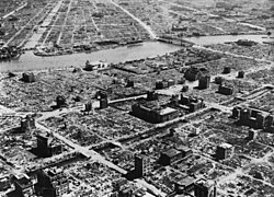
Although Japan enjoyed significant success in the initial stages of the war and rapidly expanded its sphere of influence, the Doolittle Raid on 18 April 1942, marked the first direct foreign attack on Tokyo. Although the physical damage was minimal, the raid demonstrated the vulnerability of the Japanese mainland to air attacks and boosted American morale.[48] Large-scale Allied air bombing of cities in the Japanese home islands, including Tokyo, began in late 1944 when the US seized control of the Mariana Islands. From these islands, newly developed long-range B-29 bombers could conduct return journeys. The bombing of Tokyo in 1944 and 1945 is estimated to have killed between 75,000 and 200,000 civilians and left more than half of the city destroyed.[49]
The deadliest night of the war came on March 9–10, 1945, the night of the American "Operation Meetinghouse" raid.[50] Nearly 700,000 incendiary bombs were dropped on the east end of the city (shitamachi, 下町), an area with a high concentration of factories and working-class houses. Two-fifths of the city were completely burned, more than 276,000 buildings were destroyed, 100,000 civilians were killed, and 110,000 more were injured.[51][52] Numerous Edo and Meiji-era buildings of historical significance were destroyed, including the main building of the Imperial Palace, Sensō-ji, Zōjō-ji, Sengaku-ji and Kabuki-za. Between 1940 and 1945, the population of Tokyo dwindled from 6,700,000 to less than 2,800,000, as soldiers were sent to the front and children were evacuated.[53]
The 1964 Olympics in Tokyo symbolized the transition of the city from bombed-out ruins to a modern metropolis.
After the war, Tokyo became the base from which the Allied Occupational Forces, under Douglas MacArthur, an American general, administered Japan for six years. The original rebuilding plan of Tokyo was based on a plan modelled after the Metropolitan Green Belt of London, devised in the 1930s but canceled due to the war.[54] However, due to the monetary contraction policy known as the Dodge Line, named after Joseph Dodge, the neoliberal economic advisor to MacArthur, the plan had to be reduced to a minimal one focusing on transport and other infrastructure. In 1947, the 35 pre-war special wards were reorganized into the current 23 wards. Tokyo did not experience fast economic growth until around 1950, when heavy industry output returned to pre-war levels.[55][54]
Since around the time the Allied occupation of Japan ended in 1952, Tokyo's focus shifted from rebuilding to developing beyond its pre-war stature. From the 1950s onwards, Tokyo's Metro and railway network saw significant expansion, culminating in the launch of the world's first dedicated high-speed railway line, the Shinkansen, between Tokyo and Osaka in 1964. The same year saw the development of other transport infrastructure such as the Shuto Expressway to meet the increased demand brought about by the 1964 Tokyo Olympics, the first Olympic Games held in Asia. Around this time, the 31-metre height restriction, imposed on all buildings since 1920, was relaxed due to the increased demand for office buildings and advancements in earthquake-proof construction.[56] Starting with the Kasumigaseki Building (147 metres) in 1968, skyscrapers began to dominate Tokyo's skyline. During this period of rapid rebuilding, Tokyo celebrated its 500th anniversary in 1956[57] and the Ogasawara Islands, which had been under control of the US since the war ended, were returned in 1968.[58]Ryokichi Minobe, a Marxian economist who served as the governor for 12 years starting in 1967, is remembered for his welfare state policy, including free healthcare for the elderly and financial support for households with children, and his ‘war against pollution’ policy, as well as the large government deficit they caused.[59]
Shinjuku's development as a business district started in the 1970s.
Although the 1973 oil crisis put an end to the rapid post-war recovery and development of Japan's economy, its position as the world's second-largest economy at the time had seemed secure by that point, remaining so until 2010 when it was surpassed by China.[60] Tokyo's development was sustained by its status as the economic, political, and cultural hub of such a country. In 1978, after years of the intense Sanrizuka Struggle, Narita International Airport opened as the new gateway to the city, while the relatively small Haneda Airport switched to primarily domestic flights.[61]West Shinjuku, which had been occupied by the vast Yodobashi Water Purification Centre until 1965, became the site of an entirely new business district characterized by skyscrapers surpassing 200 metres during this period.[62]
The American-led Plaza Accord in 1985, which aimed to depreciate the US dollar, had a devastating effect on Japan's manufacturing sector, particularly affecting small to mid-size companies based in Tokyo.[63] This led the government to adopt a domestic-demand-focused economic policy, ultimately causing an asset price bubble. Land redevelopment projects were planned across the city, and real estate prices skyrocketed. By 1990, the estimated value of the Imperial Palace surpassed that of the entire state of California.[64] The Tokyo Stock Exchange became the largest stock exchange in the world by market capitalization, with the Tokyo-based NTT becoming the most highly valued company globally.[18][65]
The 2020 Olympics were postponed and held in 2021 due to the COVID-19 pandemic.
After the bubble burst in the early 1990s, Japan experienced a prolonged economic downturn called the "Lost Decades", which was charactized by extremely low or negative economic growth, deflation, stagnant asset prices.[66] Tokyo's status as a world city is said to have depreciated greatly during these three decades. Nonetheless, Tokyo still saw new urban developments during this period. Recent projects include Ebisu Garden Place, Tennōzu Isle, Shiodome, Roppongi Hills, Shinagawa, and the Marunouchi side of Tokyo Station. Land reclamation projects in Tokyo have also been going on for centuries. The most prominent is the Odaiba area, now a major shopping and entertainment center. Various plans have been proposed[67] for transferring national government functions from Tokyo to secondary capitals in other regions of Japan, to slow down rapid development in Tokyo and revitalize economically lagging areas of the country. These plans have been controversial[68] within Japan and have yet to be realized.
On September 7, 2013, the IOC selected Tokyo to host the 2020 Summer Olympics. Thus, Tokyo became the first Asian city to host the Olympic Games twice.[69] However, the 2020 Olympic Games were postponed and held from July 23 to August 8, 2021, as a result of the COVID-19 pandemic.[70]
Under Japanese law, the prefecture of Tokyo is designated as a to (都), translated as metropolis.[71] Tokyo Prefecture is the most populous prefecture and the densest, with 6,100 inhabitants per square kilometer (16,000/sq mi); by geographic area it is the third-smallest, above only Osaka and Kagawa. Its administrative structure is similar to that of Japan's other prefectures. The 23 special wards (特別区, tokubetsu-ku), which until 1943 constituted the city of Tokyo, are self-governing municipalities, each having a mayor, a council, and the status of a city.
In addition to these 23 special wards, Tokyo also includes 26 more cities (市-shi), five towns (町-chō or machi), and eight villages (村-son or -mura), each of which has a local government. The Tokyo Metropolitan Government administers the whole metropolis including the 23 special wards and the cities and towns that constitute the prefecture. It is headed by a publicly elected governor and metropolitan assembly. Its headquarters is in Shinjuku Ward.
The governor of Tokyo is elected every four years. The incumbent governor, Yuriko Koike, was elected in 2016, following the resignation of her predecessor, Yoichi Masuzoe. She was re-elected in 2020 and in 2024. The legislature of the Metropolis is called the Metropolitan Assembly, and it has one house with 127 seats. The assembly is responsible for enacting and amending prefectural ordinances, approving the budget (8.5 trillion yen in fiscal 2024),[72] and voting on important administrative appointments made by the governor, including the vice governors. Its members are also elected on a four-year cycle.[73]
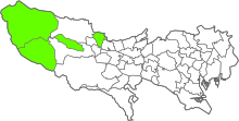
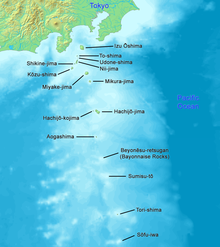
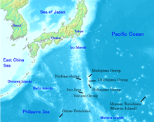
A map with Nishi-Tama District in greenA map of the Izu Islands with black labelsA map of the Ogasawara Islands with black labels
Since the completion of the Great Mergers of Heisei in 2001, Tokyo consists of 62 municipalities: 23 special wards, 26 cities, 5 towns and 8 villages. All municipalities in Japan have a directly elected mayor and a directly elected assembly, each elected on independent four-year cycles. The 23 Special Wards cover the area that had been Tokyo City until 1943, 30 other municipalities are located in the Tama area, and the remeining 9 are on Tokyo's outlying islands.
The special wards (特別区, tokubetsu-ku) of Tokyo comprise the area formerly incorporated as Tokyo City. Each special ward has used the word "city" in their official English name in recent times (e.g. Chiyoda City), but their status is more akin to boroughs in London or New York. Certain municipal functions, such as waterworks, sewerage, and fire-fighting, are handled by the Tokyo Metropolitan Government rather than each ward. To pay for the added administrative costs, the Metropolitan Government collects municipal taxes, which would usually be levied by each ward.[74] The "three central wards" of Tokyo – Chiyoda, Chūō and Minato – are the business core of the city, with a daytime population more than seven times higher than their nighttime population.[75] Chiyoda Ward is occupied by many major Japanese companies and is also the seat of the national government, and the Emperor of Japan, yet is one of the least populated wards.[76]
To the west of the special wards, Tokyo Metropolis consists of cities, towns, and villages that enjoy the same legal status as those elsewhere in Japan. While serving as "bed towns" for those working in central Tokyo, some of them also have a local commercial and industrial base, such as Tachikawa. Collectively, these are often known as the Tama area or Western Tokyo. The far west of the Tama area is occupied by the district (gun) of Nishi-Tama. Much of this area is mountainous and unsuitable for urbanization. The highest mountain in Tokyo, Mount Kumotori, is 2,017 m (6,617 ft) high; other mountains in Tokyo include Takanosu (1,737 m (5,699 ft)), Odake (1,266 m (4,154 ft)), and Mitake (929 m (3,048 ft)). Lake Okutama, on the Tama River near Yamanashi Prefecture, is Tokyo's largest lake and serves as the primary reservoir for Tokyo's water supply. The district is composed of three towns (Hinode, Mizuho and Okutama) and one village (Hinohara). The Tokyo Metropolitan Government has designated Hachiōji, Tachikawa, Machida, Ōme and Tama New Town as regional centers of the Tama area.[77]
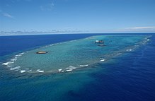
Okinotorishima, 1,740km (1,081mi) away from central Tokyo and the southernmost island of JapanTokyo has numerous outlying islands, which extend as far as 1,850 km (1,150 mi) from central Tokyo. Because of the islands' distance from the administrative headquarters of the Tokyo Metropolitan Government in Shinjuku, local subprefectural branch offices administer them. The Izu Islands are a group of volcanic islands and form part of the Fuji-Hakone-Izu National Park. The islands in order from closest to Tokyo are Izu Ōshima, Toshima, Nii-jima, Shikine-jima, Kōzu-shima, Miyake-jima, Mikurajima, Hachijō-jima, and Aogashima. The Izu Islands are grouped into three subprefectures. Izu Ōshima and Hachijojima are towns. The remaining islands are six villages, with Niijima and Shikinejima forming one village. The Ogasawara Islands include, from north to south, Chichi-jima, Nishinoshima, Haha-jima, Kita Iwo Jima, Iwo Jima, and Minami Iwo Jima. Ogasawara also administers two small outlying islands: Minami Torishima, the easternmost point in Japan and at 1,850 km (1,150 mi) the most distant island from central Tokyo, and Okinotorishima, the southernmost point in Japan.[78] Japan's claim on an exclusive economic zone (EEZ) surrounding Okinotorishima is contested by China and South Korea as they regard Okinotorishima as uninhabitable rocks which have no EEZ.[79] The Iwo chain and the outlying islands have no permanent population, but hosts Japan Self-Defense Forces personnel. Local populations are only found on Chichi-Jima and Haha-Jima. The islands form both Ogasawara Subprefecture and the village of Ogasawara, Tokyo.
This section needs to be updated. Please help update this article to reflect recent events or newly available information.(May 2024)
Tokyo has enacted a measure to cut greenhouse gases. Governor Shintaro Ishihara created Japan's first emissions cap system, aiming to reduce greenhouse gas emission by a total of 25% by 2020 from the 2000 level.[81] Tokyo is an example of an urban heat island, and the phenomenon is especially serious in its special wards.[82][83] According to the Tokyo Metropolitan Government,[84] the annual mean temperature has increased by about 3 °C (5.4 °F) over the past 100 years. Tokyo has been cited as a "convincing example of the relationship between urban growth and climate".[82]
In 2006, Tokyo enacted the "10 Year Project for Green Tokyo" to be realized by 2016. It set a goal of increasing roadside trees in Tokyo to 1 million (from 480,000), and adding 1,000 ha (2,500 acres) of green space, 88 ha (220 acres) of which will be a new park named "Umi no Mori" (Sea Forest) which will be on a reclaimed island in Tokyo Bay which used to be a landfill.[85] From 2007 to 2010, 436 ha (1,080 acres) of the planned 1,000 ha of green space was created and 220,000 trees were planted, bringing the total to 700,000. As of 2014[update], roadside trees in Tokyo have increased to 950,000, and a further 300 ha (740 acres) of green space has been added.[86]
The mainland portion of Tokyo lies northwest of Tokyo Bay and measures about 90 km (56 mi) east to west and 25 km (16 mi) north to south. The average elevation in Tokyo is 40 m (131 ft).[89]Chiba Prefecture borders it to the east, Yamanashi to the west, Kanagawa to the south, and Saitama to the north. Mainland Tokyo is further subdivided into the special wards (occupying the eastern half) and the Tama area (多摩地域) stretching westwards. Tokyo has a latitude of 35.65 (near the 36th parallel north), which makes it more southern than Rome (41.90), Madrid (40.41), New York City (40.71) and Beijing (39.91).[90]
Within the administrative boundaries of Tokyo Metropolis are two island chains in the Pacific Ocean directly south: the Izu Islands, and the Ogasawara Islands, which stretch more than 1,000 km (620 mi) away from the mainland. Because of these islands and the mountainous regions to the west, Tokyo's overall population density figures far under-represent the real figures for the urban and suburban regions of Tokyo.[91]
The former city of Tokyo and the majority of Tokyo prefecture lie in the humid subtropical climate zone (Köppen climate classification: Cfa),[92] with hot, humid summers and mild to cool winters with occasional cold spells. The region, like much of Japan, experiences a one-month seasonal lag. The warmest month is August, which averages 26.9 °C (80.4 °F). The coolest month is January, averaging 5.4 °C (41.7 °F). The record low temperature was −9.2 °C (15.4 °F) on January 13, 1876. The record high was 39.5 °C (103.1 °F) on July 20, 2004.
The record highest low temperature is 30.3 °C (86.5 °F), on August 12, 2013, making Tokyo one of only seven observation sites in Japan that have recorded a low temperature over 30 °C (86.0 °F).[93]
Annual rainfall averages nearly 1,600 millimeters (63.0 in), with a wetter summer and a drier winter. The growing season in Tokyo lasts for about 322 days from around mid-February to early January.[94] Snowfall is sporadic, and occurs almost annually.[95] Tokyo often sees typhoons every year, though few are strong. The wettest month since records began in 1876 was October 2004, with 780 millimeters (30 in) of rain,[96] including 270.5 mm (10.65 in) on the ninth of that month.[97] The most recent of four months on record to observe no precipitation is December 1995.[93] Annual precipitation has ranged from 879.5 mm (34.63 in) in 1984 to 2,229.6 mm (87.78 in) in 1938.[93]
The climates of Tokyo's offshore territories vary significantly from those of the city. The climate of Chichijima in Ogasawara village is on the boundary between the tropical savanna climate (Köppen classification: Aw) and the tropical rainforest climate (Köppen classification: Af). It is approximately 1,000 km (621 mi) south of the Greater Tokyo Area, resulting in much different climatic conditions.
Climate data for Chichijima, Ogasawara, Tokyo, 1991–2020 normals, extremes 1896–present
Tokyo's easternmost territory, the island of Minamitorishima in Ogasawara village, is in the tropical savanna climate zone (Köppen classification: Aw). Tokyo's Izu and Ogasawara islands are affected by an average of 5.4 typhoons a year, compared to 3.1 in mainland Kantō.[109]
Tokyo is near the boundary of three plates, making it an extremely active region for smaller quakes and slippage which frequently affect the urban area with swaying as if in a boat, although epicenters within mainland Tokyo (excluding Tokyo's 2,000 km (1,243 mi)–long island jurisdiction) are quite rare. It is not uncommon in the metro area to have hundreds of these minor quakes (magnitudes 4–6) that can be felt in a single year, something local residents merely brush off but can be a source of anxiety not only for foreign visitors but for Japanese from elsewhere as well. They rarely cause much damage (sometimes a few injuries) as they are either too small or far away as quakes tend to dance around the region. Particularly active are offshore regions and to a lesser extent Chiba and Ibaraki.[110]
Tokyo has been hit by powerful megathrust earthquakes in 1703, 1782, 1812, 1855, 1923, and much more indirectly (with some liquefaction in landfill zones) in 2011;[111][112] the frequency of direct and large quakes is a relative rarity. The 1923 earthquake, with an estimated magnitude of 7.9, killed more than 100,000 people, the last time the urban area was directly hit.[113][114][115]
Mount Fuji has posed the primary volcanic threat to Tokyo's citizens for centuries.
Mount Fuji is about 100 km (62 mi) southwest of Tokyo. There is a low risk of eruption. The last recorded was the Hōei eruption which started on December 16, 1707, and ended about January 1, 1708 (16 days).[116] During the Hōei eruption, the ash amount was 4 cm in southern Tokyo (bay area) and 2 cm to 0.5 cm in central Tokyo.[117]Kanagawa had 16 cm to 8 cm ash and Saitama 0.5 to 0 cm.[117] If the wind blows north-east it could send volcanic ash to Tokyo metropolis.[118] According to the government, less than a millimeter of the volcanic ash from a Mount Fuji eruption could cause power grid problems such as blackouts and stop trains in the Tokyo metropolitan area.[118] A mixture of ash with rain could stick to cellphone antennas, power lines and cause temporary power outages.[118] The affected areas would need to be evacuated.[118]
Tokyo is located on the Kantō Plain with five river systems and dozens of rivers that expand during each season.[119] Important rivers are Edogawa, Nakagawa, Arakawa, Kandagawa, Megurogawa and Tamagawa.[120] In 1947, Typhoon Kathleen struck Tokyo, destroying 31,000 homes and killing 1,100 people.[119] In 1958, Typhoon Ida dropped 400 mm (16 in) of rain in a single week, causing streets to flood.[119] In the 1950s and 1960s, the government invested 6–7% of the national budget on disaster and risk reduction.[119] A huge system of dams, levees and tunnels was constructed.[119] The purpose is to manage heavy rain, typhonic rain, and river floods.[119]
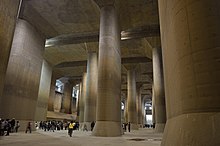
The MAOUDC is the world's largest underground floodwater diversion facility.
Tokyo has currently the world's largest underground floodwater diversion facility called the Metropolitan Area Outer Underground Discharge Channel (MAOUDC).[121][119] It took 13 years to build and was completed in 2006. The MAOUDC is a 6.3 km (3.9 mi) long system of tunnels, 22 meters (72 ft) underground, with 70-meter (230 ft) tall cylindrical tanks, each tank being large enough to fit a space shuttle or the Statue of Liberty.[119] During floods, excess water is collected from rivers and drained to the Edo River.[120] Low-lying areas of Kōtō, Edogawa, Sumida, Katsushika, Taitō and Arakawa near the Arakawa River are most at risk of flooding.[120]
Tokyo's buildings are too diverse to be characterized by any specific archtectural style, but it can be generally said that a majority of extant structures were built in the past a hundred years;[122] twice in recent history has the metropolis been left in ruins: first in the 1923 Great Kantō earthquake and later after extensive firebombing in World War II.[122]
The oldest known extant building in Tokyo is Shofukuji in Higashi-Murayama. The current building was constructed in 1407, during the Muromachi period (1336–1573).[123] Although greatly reduced in number by later fires, earthquakes, and air raids, a considerable number of Edo-era buildings survive to this day. The Tokyo Imperial Palace, which was occupied by the Tokugawa Shogunate as Edo Castle during the Edo Period (1603–1868), has many gates and towers dating from that era, although the main palace buildings and the tenshu tower have been lost.[124]
Numerous temple and shrine buildings in Tokyo date from this era: the Ueno Toshogu still maintains the original 1651 building built by the third shogun Iemitsu Tokugawa.[125] Although partially destroyed during the Second World War, Zojo-ji, which houses the Tokugawa family mausoleum, still has grand Edo-era buildings such as the Sangedatsu gate.[126]Kaneiji has grand 17th-century buildings such as the five-storey pagoda and the Shimizudo. The Nezu Shrine and Gokokuji were built by the fifth shogun Tsunayoshi Tokugawa in the late 1600s. All feudal lords (daimyo) had large Edo houses where they stayed when in Edo; at one point, these houses amounted to half the total area of Edo.[127] None of the grand Edo-era daimyo houses still exist in Tokyo, as their vast land footprint made them easy targets for redevelopment programs for modernization during the Meiji Period. Some gardens were immune from such fates and are today open to the public; Hamarikyu (Kofu Tokugawa family), Shibarikyu (Kishu Tokugawa family), Koishikawa Korakuen (Mito Tokugawa family), Rikugien (Yanagisawa family), and Higo Hosokawa Garden (Hosokawa family). The Akamon, which is now widely seen as a symbol of the University of Tokyo, was originally built to commemorate the marriage of a shogun's daughter into the Maeda clan, one of the most affluent of the feudal lords, while the campus itself occupies their former edo estate.[128]
Edo, 1865 or 1866. Photochrom print. Five albumen prints joined to form a panorama. Photographer: Felice Beato.
The Meiji era saw a rapid modernization in architectural styles as well; until the Great Kanto Earthquake in 1923 exposed their weakness to seimic shocks, grand brick buildings were constantly built across the city. Tokyo Station (1914), the Ministry of Justice building (1895) and Mistubishi building one (1894, rebuilt in 2010) are some of the few brick survivors from this period. It was regarded as fashionable by some members of the Japanese aristocracy to build their Tokyo residences in grand and modern styles, and some of these buildings still exist, although most are in private hands and open to the public on limited occasions. Aristocratic residences today open to the public include the Marquess Maeda residence in Komaba, the Baron Iwasaki residence in Ikenohata and the Baron Furukawa residence in Nishigahara.
Extant concrete buildings from the interwar period
The 1930s saw the rise of styles that combined characteristics of both traditional Japanese and modern designs. Chuta Ito was a leading figure in this movement, and his extant works in Tokyo include Tsukiji Hongan-ji (1934). The Imperial Crown Style, which often features Japanese-style roofs on top of elevated concrete structures, was adopted for the Tokyo National Museum in Ueno and the Kudan Hall in Kudanminami.[131]
Since the 30-metre height restriction was lifted in the 1960s, Tokyo's most dense areas have been dominated by skyscrapers. As of May 2024, there are at least 184 buildings exceeding 150 metres (492 feet) in Tokyo. Apart from these, Tokyo Tower (333m) and Tokyo Sky Tree (634m) feature high-elevation observation decks; the latter is the tallest tower in both Japan and the world, and the second tallest structure in the world after the Burj Khalifa in Dubai.[14] With a scheduled completion date in 2027, Torch Tower (385m) will overtake Azabudai Hills Mori JP Tower (325.2m) as the tallest building in Tokyo.
По состоянию на октябрь 2012 года официальная интерцендентная оценка показала 13,506 миллиона человек в Токио, с 9,214 миллионами проживает в 23 подопечных Токио. [ 132 ] В течение дневного населения население увеличивается более чем на 2,5 миллиона, когда работники и студенты едут из соседних районов. Этот эффект еще более выражен в трех центральных палатах Чиёды , Чу -жу и Минато , чье коллективное население национальной переписи 2005 года составляло 326 000 ночью, но 2,4 миллиона в течение дня. [ 133 ]
Историческое население Токио с 1920 года
Согласно официальным оценкам апреля 2024 года, Сетагая (942 003), Нерима (752 608) и OTA (748 081) были самыми густонаселенными палатами и муниципалитетами в Токио. Наименьшими из всех муниципалитетов Токио являются отдаленные островные деревни, такие как Аогасима (150), Микураджима (289) и Тосима (306). [ 134 ]
В 2021 году средний и средний возраст в Токио был 45,5 года. Это ниже национального среднего возраста в возрасте 49,0 лет, поместив Токио среди самых молодых регионов в Японии. 16,8% населения было ниже 15, в то время как 34,6% было выше 65. [ 135 ] В том же году самыми молодыми муниципалитетами в Токио были Микура-Джима (средний возраст 40,72), Чуо (41,92) и Чийода (42,07), в то время как самые старые включали Окутаму (59,11) и Мияке (53,82). [ 136 ]
В 1889 году министерство внутренних дел зарегистрировало 1 375 937 человек в Токийском городе и в общей сложности 1 694 292 человек в Токио-Фу . [ 137 ] В том же году в Токио было зарегистрировано 779 иностранных граждан. Наиболее распространенной гражданством было английский (209 жителей), за которыми следуют американские (182) и граждане Китая (137). [ 138 ]
По состоянию на январь 2024 года в Токио было зарегистрировано 647 416 иностранных граждан, а в Китае, Южной Корее, Вьетнаме, Филиппинах, Непале, Тайване и в Соединенных Штатах было более 20 000 граждан, проживающих там в качестве граждан. [ 139 ] С тех пор, как пандемия Covid-19 закончилась, иностранное население Токио значительно увеличилось, в настоящее время почти на 20% выше населения в январе 2022 года в 546 436 человек. [ 140 ] По состоянию на официальное обследование расы или места рождения не проведено.
Японский является основным языком, на котором говорят во всем мегаполисе, хотя региональные и социально-экономические различия можно услышать. Традиционно, диалекты в Токио классифицируются на две группы: диалект яманот и диалект Shitamachi. Первые традиционно говорили в жилом районе высшего и высшего класса в Яманоте, в который входят Банчо , Кодзимачи , Коишикава , Кудан , Йотсуя , Азабу и Акасака . В течение периода Эдо эти районы были заняты Даймио и другими влиятельными семьями самураев , и диалект развивался в основном на основе их способа речи. Стандартное японское произношение в значительной степени основано на этом акценте и распространяется по всей стране с введением радио . Диалект Thitamachi, напротив, был связан с районом Чинина Ширамачи и сохраняет много характеристик акцентов, произнесенных там в эпоху Эдо. [ 141 ] Тем не менее, социально-экономические изменения в послевоенный период и большой приток людей, переезжающих из других областей, в последние годы в значительной степени размыли эти различия. Сообщалось, что молодые поколения не знают о различиях в диалектах, как поколения их родителей и бабушки и дедушки. [ 142 ]
Marunouchi , основной деловой район Разбивка сектора ВВП Токио в 2021 году
Валовой региональный продукт Токио составил 113,7 триллиона иену или 1,04 трлн долларов США в 2021 финансовом году, что составило 20,7% от общего экономического производства страны, что превращается в 8,07 млн. Иен или 73 820 долларов США на душу населения. [ 16 ] По сектору, оптовой торговле и розничной торговле были крупнейшим вкладчиком, составляя 21,5% от общего объема производства. За этим последовали недвижимость (13,5%), профессиональная, научная и техническая (12,2%), информация и связь (11,7%), финансы и страхование (7,6%), производство (7,0%) и здравоохранение (6,7%). Сельское хозяйство, лесное хозяйство и рыболовство, а также добыча в сочетании составляли менее 0,1% экономического производства. [ 147 ] Как предполагают эти цифры, экономика Токио сильно зависит от третичного сектора. Будучи районом Большого Токио , в нем есть вторая по величине столичная экономика в мире после Большого Нью-Йорка , а валовой столичный продукт оценивается в 2 триллиона долларов США. Экономика района немного меньше, чем экономика Канады, в то же время будет немного больше, чем в Мексике . и , согласно оценкам МВФ, того же года, [ 148 ]
Токио является крупным международным финансовым центром; [ 156 ] В нем содержится штаб -квартира нескольких крупнейших инвестиционных банков и страховых компаний в мире и служит центром для японской транспортной, издательской, электроники и вещательной промышленности. Во время централизованного роста экономики Японии после Второй мировой войны многие крупные фирмы перевели свою штаб -квартиру из таких городов, как Осака (исторический коммерческий капитал) в Токио, в попытке воспользоваться лучшим доступом к правительству.
Японский финансовый рынок медленно открывался в 1984 году и ускорил его интернационализацию с «Японским Большим взрывом» в 1998 году. [ 159 ] Несмотря на появление Сингапура и Гонконга в качестве конкурирующих финансовых центров, Tokyo IFC удается сохранить видную позицию в Азии. Токийская фондовая биржа является крупнейшей Японской фондовой биржей и третьей по величине в мире по рыночной капитализации и четвертой по величине с оборотом акций. В 1990 году в конце японского пузыря цен на активы на него приходилось более 60% мирового рынка фондового рынка. [ 160 ]
В 2019 году на туризм составлял чуть более одного процента от общего экономического производства Токио, причем 15,18 миллиона иностранных посетителей тратили 1,26 триллиона иен, согласно правительству столицы Токио. [ 162 ]
Согласно правительственному опросу 2022 года, наиболее посещаемыми районами в Токио были: [ 163 ]
Рынок Toyosu в Токио является крупнейшим оптовым рынком рыб и морепродуктов в мире с момента его открытия 11 октября 2018 года. [ 165 ] Это также один из крупнейших оптовых пищевых рынков. Он расположен в районе Тойосу в Уорде Кето . Рынок Toyosu придерживается традиций своего предшественника, рыбного рынка Цукиджи и рыбного рынка Nihonbashi , и каждый день обслуживает около 50 000 покупателей и продавцов. Ритейлеры, целые продавцы, аукционисты и общественные граждане часто посещают рынок, создавая уникальный микрокосм организованного хаоса, который все еще продолжает питать город и его продовольствие более четырех веков. [ 166 ]
Токио имел 8 460 гектаров (20 900 акров) сельскохозяйственных земель с 2003 года, [ 167 ] По данным Министерства сельского хозяйства, лесного хозяйства и рыболовства , ставя его в последнюю очередь среди префектур страны. Сельскохозяйственные угодья сосредоточены в западном Токио. Периканты, такие как овощи, фрукты и цветы, могут быть удобно отправлены на рынки в восточной части префектуры.
С 36% его территории, покрываемым лесом, Токио имеет обширный рост криптомерии и японского кипариса , особенно в горных западных общинах Акируно, Оме, Окутамы, Хачиджи, Хиноде и Хинохары. Снижение цены древесины, увеличение стоимости производства и повышение старости среди населения лесного хозяйства привело к снижению производства Токио. Кроме того, пыльца, особенно из криптомерии, является основным аллергеном для близлежащих населенных центров. Токийский залив когда -то был основным источником рыбы. Большая часть рыбной продукции Токио поступает от внешних островов, таких как Изу Ошима и Хахиджо-джима. Skipjack Tuna , Nori и AJI входят в число океанских продуктов. [ 168 ]
Токио, который является центром в районе Большого Токио , является крупнейшим внутренним и международным центром Японии для железнодорожного и наземного транспорта. В общественном транспорте в Токио преобладает обширная сеть «чистой и эффективной» [ 169 ] Поезда и метро, управляемые различными операторами, с автобусами, монорельсами и трамваями, играющими вторичную фидерную роль. В Токио насчитывается до 62 электрических железнодорожных линий и более 900 железнодорожных станций. [ 170 ] Shibuya Crossing - это «самый оживленный пешеходный перекресток в мире», причем около 3000 человек пересекаются за раз. [ 171 ] [ 172 ] [ 173 ]
Рельса является основным способом транспортировки в Токио, [ 174 ] который имеет наиболее обширную городскую железнодорожную сеть в мире и одинаково обширная сеть поверхностных линий. JR East управляет крупнейшей железнодорожной сетью Токио, включая петлю Line Line Yamanote , которая окружает Центральный Токио. Он управляет железнодорожными линиями по всей столичной области Токио и остальной части северо -восточного Хоншу. JR East также отвечает за Shinkansen высокоскоростные железнодорожные линии , которые связывают Токио и северо-восточные города Японии ( Джотсу Шинкансен , Тохоку/Хоккайдо Шинкансен , Ямагата Шинкансен , Акита Шинкансен , Хокурику Шинкансен ). [ 175 ] Tokaido Shinkansen , который связывает Токио и Осаку через Нагою и Киото , а также западные города за пределами, управляется JR Central . Chuo Shinkansen , первая в мире высокоскоростная плавающая линия Maglev в настоящее время, также будет эксплуатироваться Jr Central. Обе компании JR были созданы из приватизации Японских национальных железных дорог в 1987 году. JR Freight не владеет какой -либо частью железнодорожной сети, но управляет грузовыми поездами в сети JR .
Две разные организации управляют подземной железнодорожной сетью Токио: приватизированное токийское метро , которое управляет токийскими линиями метро и правительственным столичным бюро транспорта Токио , которое управляет линиями TOEI. Tokyo Metro полностью принадлежит японскому правительству и правительству столичности Токио , так как оно было приватизировано в 2004 году (ранее это было государственным организацией, называемой Имперской столицей Rapid Transit Управление с 1941 по 2004 год), но планировалось стать публичным в 2024 году. [ 176 ] Другие крупные железнодорожные операторы в Токио включают Одакю , Токи , Кейо , Сейбу , Тобу и Кейсей . Хотя каждый оператор непосредственно владеет своими железнодорожными линиями, посредством услуг, которые проходят по разным линии, принадлежащие различным операторам, являются обычными.
У Токио однажды была обширная трамвайная сеть с общим расстоянием 213 км ( Токио Тоден ). Однако, как и в других крупных городах по всему миру, возраст моторизации с 1950 -х годов заставил его считать непригодными для обмена оживленными дорогами с автомобилями. Сегодня остается только одна линия, линия Аракава . [ 177 ]
Токио имеет самый низкий уровень владения автомобилем среди всех префектур в Японии, с 0,416 автомобилями на домохозяйство по сравнению со средним показателем по стране 1,025 на домохозяйство. Это несмотря на то, что Токио является одним из самых богатых районов в стране, с номинальным ВВП на душу населения около 75 000 долларов США. [ 178 ] Опрос 2021 года показал, что 81% респондентов без автомобиля были удовлетворены общественным транспортом и не увидели необходимости иметь его. [ 179 ]
Каждая дорога в Токио попадает в одну из следующих категорий в зависимости от типа владения: частные дороги, муниципальные дороги, столичные дороги и скоростные автомагистрали. По состоянию на 1 апреля 2022 года общая длина дорог в Токио составляет приблизительно 24 741 км (включая 2370 км столичных дорог), общая площадь приблизительно 190,31 км 2 (в том числе 46,30 км 2 столичных дорог). [ 180 ]
Межгородные скоростные автомагистрали в Токио и его окрестностях управляются Nexco East , в то время как скоростные автомагистрали, которые служат только в районе Большого Токио ( Shoto Spressway ), управляются столичной скоростной автомагистралью. Производители собираются на основе пройденного расстояния. Общая длина скоростной автомагистрали Shoto составляет 337,8 км, с ограничениями скорости обычно устанавливаются на уровне 80 км/ч или 60 км/ч, чтобы уменьшить шумовое загрязнение и приспособление к относительно извилистым дорожным формам. [ 181 ]
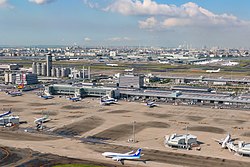
Материкская часть Токио обслуживается двумя международными аэропортами: аэропортом Ханеда в Эта и Международном аэропорту Нарита в соседней префектуре Чиба . Ханеда была основным аэропортом Токио с 1931 года. Однако в реактивном возрасте наблюдалось экспоненциальное увеличение рейсов, что побудило правительство построить второй аэропорт. Нарита была выбрана в качестве места для этого второго аэропорта в 1966 году, но местные фермеры и левые активисты, которые сочувствовали им, яростно протестовал протестовал на более десяти лет ( борьба Санризука ), откладывая открытие нового аэропорта до 1978 года. Почти все международные рейсы были переведены в аэропорт Нарита после его завершения, и Ханеда стала главным образом внутренним аэропортом. [ 182 ]
Ситуация изменилась, когда было решено расширить аэропорт Ханеды и построить новые взлетно-посадочные полосы в 2001 году. Новая взлетно-посадочная полоса, взлетно-посадочная полоса D была построена частично в качестве пирса, а не как позади, чтобы не препятствовать потоку воды в заливе. [ 183 ] Его открытие в 2010 году ознаменовало возвращение международных рейсов в Ханеда, которая намного ближе к Центральному Токио. В 2023 году Ханеда справилась с 17,9 млн. Международных пассажиров и 60,8 миллиона местных пассажиров, [ 184 ] В то время как Нарита использовалась 25,4 миллионами международных пассажиров и 7,7 миллионами внутренних пассажиров. [ 185 ] Согласно опросу 2023 года, Ханеда является пятым самым загруженным аэропортом в мире благодаря пассажирскому движению .
Водный транспорт является основным средством импорта и экспорта товаров, а также соединения Токийских островов с материком. Согласно списку Ллойда , в 2022 году порт Токио занимался 4 430 000 TEU контейнеров, что делает его 46 -м по величине портом в мире. [ 186 ] Большой токийский район обслуживается другими крупными портами, такими как порт Йокогама и порт Чиба .
Pier Pier (竹芝埠頭 竹芝埠頭) в Минато используется Tōkai Kisen , который обслуживает такие острова, как Изу Ошима , Миякеджима , Хачиджоджима , Козушима , [ 187 ] и Огасавара Кайун, который обслуживает острова Огасавара . [ 188 ] Многие из этих островов доступны только по океанским маршрутам и вертолетам, так как они слишком маленькие или волнистые для посадочной площадки, что делает эти корабли основными средствами межстленкового транспорта. Есть паромные маршруты, которые соединяют достопримечательности и в материковой части Токио; и Круизный корабль Токио линия Токио Мизубе управляют несколькими маршрутами между туристическими достопримечательностями, такими как Асакуса , Хамарикию , Одайба и Аквариум Шинагава. [ 189 ] Symphony Cruise управляет двумя большими ресторанными кораблями, которые также можно нанять в качестве вечеринок. [ 190 ]
Токио - образовательный, академический и культурный центр Японии. От начальных до третичных уровней, многочисленные учебные заведения работают в городе, чтобы удовлетворить разнообразные ученики и студентов.
Токио является сердцем высшего образования в стране, где проживает 143 уполномоченных университетов в 2020 году. [ 191 ] Это число включает в себя самые престижные и избирательные университеты страны, такие как Университет Токио ( QS National : 1st), Токийский технологический институт (4 -е место), Университет Хитотсубаши (15 -е место), Университет Васеда (9 -е место) и Университет Кейо (10th ) [ 192 ] Кроме того, Токийский университет искусств широко рассматривается как самая престижная живопись, скульптура, ремесла и музыкальная школа в стране. [ 193 ] Университет Организации Объединенных Наций , который является академическим подразделением Организации Объединенных Наций , со штаб -квартирой в Сибуя , Токио. В 2024 году QS Best Student Cities считал Токио вторым лучшим городом для студентов университетов после Лондона . [ 194 ] Рейтинг отметил, что Токио идеально подходит для «тех, кто предпочитает полное погружение в местную культуру, а не живет в« студенческом пузыре », заявляя, что, несмотря на то, что имеют высокопоставленные университеты и крупные глобальные компании, предлагающие стажировку, а также богатую культуру, Токио все еще имеет очень низкое международное соотношение студентов. [ 195 ]
На среднем уровне 429 старших средних школ расположены в Токио, шесть из которых являются национальными, 186 являются общедоступными и 237 являются частными. [ 196 ] Некоторые старшие школы, часто престижные национальные или частные, работают совместно со своими аффилированными средними школами, предоставляя шестилетние образовательные программы ( Chūkō Ikkan Kyōiku ). Академия Кайсеи , [ 197 ] Komaba Junior & Senior High School, Университет Цукуба , [ 198 ] Средняя школа Азабу , а также младшая и старшая средняя школа Oin , [ 199 ] Крупнейшие источники успешных кандидатов в высший университет страны, Университет Токио, [ 200 ] некоторые примеры таких. На основном уровне в Токио в Токио присутствуют 1332 начальных школ. Шесть из них национальны, 1261 год являются общедоступными, а 53 - частные. [ 196 ]
Ранние современные академии, такие как Gakushuin и Keio, предоставляют всесторонние образовательные программы от начальных школ до университетов, первоначально для удовлетворения потребностей традиционно богатых и влиятельных семей. [ 201 ] Существуют международные и этнические школы, которые соблюдают национальные учебные программы их соответствующих стран или международные учебные программы, а не японские, такие как Британская школа в Токио , Токийская китайская школа , американская школа в Японии и Токио. Полем
Почти все крупные японские научные общества базируются в Токио. Японская академия страны , Академия наук , была основана в 1879 году, чтобы собрать вместе ведущих ученых в различных дисциплинах. [ 202 ] Японская художественная академия была основана в 1919 году с аналогичной целью. [ 203 ] Эти две национальные академии со штаб -квартирой в парке Уэно . Новейшая Национальная академия, Научный совет Японии , был создан в 1949 году с целью содействия научным исследованиям и применению результатов исследований для гражданской жизни. Он расположен в Роппонги, штат Минато.
Район ночной жизни в Токио сосредоточен вокруг районов на западе города, таких как Shibuya , Shinjuku и Roppongi , с высокой концентрацией баров, клубов, хозяев и хозяйковых клубов и мест живой музыки. [ 210 ] Токио также известен своими фестивалями, такими как Санно Мацури в святыне Хи , фестиваль Санджи в святыне Асакуса и биеннале Канда Мацури , на котором представлены парады с тщательно украшенными поплавками. Harajuku , расположенный в Сибуя, всемирно известен своей молодежной модой и уличной культурой, с модными магазинами, кафе и улицами Такешита. [ 211 ] Акихабара , известный как «Электрический город», является центром для электроники и культуры отаку , такой как аниме и компьютерные игры , с многочисленными магазинами, продающими аниме, мангу и игровые товары. [ 212 ] Гинза и Нихамбаши - два из самых заметных торговых районов Токио. Ginza известен своими высококачественными магазинами, где представлены магазины брендов роскоши, бутик-магазины и универмаги, такие как Mitsukoshi и Wako . В нем также есть многочисленные изысканные столовые и художественные галереи, что делает его культурным и коммерческим центром. Нихамбаши, исторически в центре торговли, имеет давние магазины и флагманский магазин Департамента Мицукоши, первый универмаг Японии, основанный в 1673 году. [ 213 ] Jinbōchō известен своей концентрацией книжных магазинов, издательских домов и литературных кафе, и его связями с большим количеством известных литературных фигур. [ 214 ]
Современные достопримечательности в Токио включают Токио Skytree в Сумиде, самая высокая структура в Японии, которая дает панорамные виды на город из его наблюдений. Одайба , искусственный остров в Токийском заливе, включает в себя магазины, столовые и развлекательные достопримечательности, такие как Музей цифрового искусства Teamlab Planets и Joypolis . парк развлечений [ 215 ] Tokyo Disney Resort и его два тематических парка Токио Диснейленд и Токио Диснезиа являются основными направлениями для семейных развлечений. Хотя эти тематические парки Диснея носят имя Токио, они на самом деле расположены в соседнем Ураясу, Чиба , к востоку от Токио.
В ноябре 2007 года Michelin выпустила свое первое руководство по изысканной столовой в Токио, наградив в общей сложности 191 звезды, или примерно вдвое больше, чем ближайший конкурент Токио, Париж. По состоянию на 2017 год 227 ресторанов в Токио были награждены (92 в Париже). Двенадцать заведений были награждены максимум три звезды (Париж имеет 10), 54 получили две звезды и 161 заработали одну звезду. [ 216 ]
Токио прошел летние Олимпийские игры 1964 года , став первым азиатским городом, который прошел летние игры . Национальный стадион, также известный как Олимпийский стадион , проходил ряд международных спортивных мероприятий. В 2016 году он должен был быть заменен новым национальным стадионом . С рядом спортивных залов мирового класса, Токио часто проводит национальные и международные спортивные мероприятия, такие как баскетбольные турниры, турниры по волейболу женского волейбола, теннисные турниры, плавательные соревнования, марафоны, регби-профсоюз и игры в регби, футбольные выставочные игры, дзюдо и каратэ и каратэт. Полем Токийский столичный гимназий в Сендагайе , Шибуя , представляет собой большой спортивный комплекс, который включает в себя бассейны, тренировочные комнаты и большую крытую арену. Согласно кольцам , в гимназии принимал участие в чемпионате мира по художественной гимнастике в октябре 2011 года, несмотря на первоначальные сомнения Федерации Международной гимнастики в способности Токио принимать чемпионаты после того, как тройная катастрофа попала в Японию. [ 224 ] Токио также был выбран для проведения ряда игр для чемпионата мира по регби 2019 года , а также для проведения летних Олимпийских игр и Паралимпийских игр 2020 года , которые должны были быть перенесены на лето 2021 года из-за пандемии Covid-19 .
^ Иглесиас, Фернандо и Изоя Синдзи. «Первый глобальный план управления для городской ландшафтной реструктуризации в Токио». Журнал Корейского института ландшафтной архитектуры International Edition 1 (2001): 176-182.
^ Михут, Мариус Иоан. «Плацца Акорд и« взрыв »японских ПИИ». Процедура Экономика и финансы 15 (2014): 721-729.
^ «Местное правительство в Японии» (PDF) . Совет местных властей по международным отношениям. п. 8. Архивировано из оригинала (PDF) 23 сентября 2008 года . Получено 14 сентября 2008 года .
^ Масато Ояма (март 2007 г.). HOEI 4 -й год (1707) Извержение (1707 извержение) . Мария Фудзи Историческое извержение (база данных извержений и других видов деятельности Фудзи вулкана (на японском языке). Университет Шизуока. Архивировано из оригинала 12 августа 2017 года . Получено 25 сентября 2008 года .
^ «Бывший замок Эдо» . Национальный институт экологических исследований и обучения (NGP) . Архивировано из оригинала 21 июня 2024 года . Получено 21 июня 2024 года .
^ Masayoshi Shibatani, 1990. Японские языки , с. 207
^ Томас Пеллард. Сравнительное исследование японских языков. Подходы к исчезающим языкам в Японии и Северо -Восточной Азии: описание, документация и оживление , Национальный институт японского языка и лингвистики, август 2018, Тачикава, Япония. FFHAL-01856152
^ Группа статистики садоводства, Отдел статистики производства, Статистика и информационная департамент, Министерство сельского хозяйства, лесного хозяйства и рыболовства (15 июля 2003 г.). «Статистика по культивируемой земле» (PDF) . Архивировано из оригинала (PDF) 24 июня 2008 года . Получено 18 октября 2008 года .
^ Бюро, Токийская конвенция и посетители. «Ночная жизнь в Токио» . Официальный путеводитель по Токио, иди Токио . Архивировано из оригинала 31 мая 2024 года . Получено 31 мая 2024 года . {{cite web}}: |last= имеет общее имя ( справка )
^ Бюро, Токийская конвенция и посетители. "Takehita-Street" . Официальный путеводитель по Токио, иди Токио . Архивировано из оригинала 31 мая 2024 года . Получено 31 мая 2024 года . {{cite web}}: |last= имеет общее имя ( справка )
^ Бюро, Токийская конвенция и посетители. "Happo-en" . Официальный путеводитель по Токио, иди Токио . Архивировано из оригинала 31 мая 2024 года . Получено 31 мая 2024 года . {{cite web}}: |last= имеет общее имя ( справка )
Фиве, Николас и Пол Уэйли. (2003). Японские столицы в исторической перспективе: место, власть и память в Киото, Эдо и Токио . Лондон: Routledgecurzon. ISBN 978-0-7007-1409-4 ; OCLC 51527561
Макклейн, Джеймс, Джон М. Мерриман и Каору Угава. (1994). Эдо и Париж: городская жизнь и государство в раннюю современную эпоху . Итака: издательство Корнелльского университета. ISBN 978-0-8014-2987-3 ; OCLC 30157716
Соренсен, Андре. (2002). Создание городской Японии: города и планирование от Эдо до двадцати первого века . Лондон: Routledgecurzon. ISBN 978-0-415-22651-6 ; OCLC 48517502
Соренсен, А. Земля, повторная корректировка и столичный рост: исследование пригородного развития земли и разрастания городов в столичном районе Токио (2000)
Уэйли, Пол. «Токо-мир-город: переоценка роли капитала и государства в городской реструктуризации». Городские исследования 2007 44 (8): 1465–1490. ISSN 0042-0980 Полный текст: EBSCO
Arc.Ask3.Ru Номер скриншота №: 0fed711ad56ccf337e054e15fca09511__1726603980 URL1:https://arc.ask3.ru/arc/aa/0f/11/0fed711ad56ccf337e054e15fca09511.html Заголовок, (Title) документа по адресу, URL1: Tokyo - Wikipedia
Данный printscreen веб страницы (снимок веб страницы, скриншот веб страницы), визуально-программная копия документа расположенного по адресу URL1 и сохраненная в файл, имеет: квалифицированную, усовершенствованную (подтверждены: метки времени, валидность сертификата), открепленную ЭЦП (приложена к данному файлу), что может быть использовано для подтверждения содержания и факта существования документа в этот момент времени. Права на данный скриншот принадлежат администрации Ask3.ru, использование в качестве доказательства только с письменного разрешения правообладателя скриншота. Администрация Ask3.ru не несет ответственности за информацию размещенную на данном скриншоте. Права на прочие зарегистрированные элементы любого права, изображенные на снимках принадлежат их владельцам. Качество перевода предоставляется как есть. Любые претензии, иски не могут быть предъявлены. Если вы не согласны с любым пунктом перечисленным выше, вы не можете использовать данный сайт и информация размещенную на нем (сайте/странице), немедленно покиньте данный сайт. В случае нарушения любого пункта перечисленного выше, штраф 55! (Пятьдесят пять факториал, Денежную единицу (имеющую самостоятельную стоимость) можете выбрать самостоятельно, выплаичвается товарами в течение 7 дней с момента нарушения.)


 Tama
Tama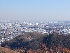


 Определения из Wiktionary
  СМИ из Commons
  Новости от Wikinews
  Учебники из Wikibooks
  Информация о путешествиях от Wikivoyage