Манхэттен

Манхэттен
округ Нью-Йорк | |
|---|---|
 Мидтаун Манхэттен в мире , крупнейший центральный деловой район , на переднем плане, Нижний Манхэттен и его финансовый район на заднем плане. | |
 Flag  Seal | |
| Etymology: Lenape: Manaháhtaan (the place where we get bows) | |
| Nickname: The City | |
 Interactive map outlining Manhattan | |
 Map of Manhattan in New York | |
 Manhattan Location within New York City | |
| Coordinates: 40°42′46″N 74°00′21″W / 40.7127°N 74.0059°W | |
| Country | |
| State | |
| County | New York County (coterminous) |
| City | New York City |
| Settled | 1624 |
| Government | |
| • Type | Borough (New York City) |
| • Borough President | Mark Levine (D) — (Borough of Manhattan) |
| • District Attorney | Alvin Bragg (D) — (New York County) |
| Area | |
| • Total | 33.58 sq mi (87.0 km2) |
| • Land | 22.83 sq mi (59.1 km2) |
| • Water | 10.76 sq mi (27.9 km2) 32% |
| Dimensions —width at 14th Street, widest | |
| • Length | 13 mi (21 km) |
| • Width | 2.3 mi (3.7 km) |
| Highest elevation | 265 ft (81 m) |
| Population | |
| • Total | 1,694,250 |
| • Estimate (2022)[3] | 1,596,273 |
| • Density | 74,781.6/sq mi (28,873.3/km2) |
| Demonyms | Manhattanite[4] Knickerbocker (historical) |
| GDP | |
| • Total | US$780.966 billion (2022) · 2nd by U.S. county; 1st per capita |
| Time zone | UTC−05:00 (EST) |
| • Summer (DST) | UTC−04:00 (EDT) |
| ZIP Code format | 100xx, 101xx, 102xx |
| Area code | 212/646/332, 917[a] |
| Website | Manhattan Borough President |


Манхэттен ( / m æ n ˈ h æ t ên , m - ə n / ) — самый густонаселенный и географически самый маленький из пяти районов Нью -Йорка . Манхэттен , совпадающий с округом Нью-Йорк , является самым маленьким по географической площади округом в американском штате Нью -Йорк . Расположенный почти полностью на острове Манхэттен, недалеко от южной оконечности штата, Манхэттен представляет собой центр северо -восточного мегаполиса и городское ядро агломерации Нью-Йорка . [ 6 ] центром Нью-Йорка Манхэттен является экономическим и административным и считается культурной, финансовой, медиа- столицей и столицей развлечений мира. [ 7 ] [ 8 ] [ 9 ] [ 10 ]
Современный Манхэттен изначально был частью территории Ленапе . [ 11 ] Европейское заселение началось с основания поста торгового голландскими колонистами в 1624 году на юге острова Манхэттен; пост был назван Новым Амстердамом в 1626 году. Территория и ее окрестности перешли под контроль Англии в 1664 году и были переименованы в Нью-Йорк после того, как король Англии Карл II пожаловал земли своему брату, герцогу Йоркскому . [12] New York, based in present-day Lower Manhattan, served as the capital of the United States from 1785 until 1790.[13] The Statue of Liberty in New York Harbor greeted millions of arriving immigrants in the late 19th century and is a world symbol of the United States and its ideals.[14] Manhattan became a borough during the consolidation of New York City in 1898, and houses New York City Hall, the seat of the city's government.[15] The Stonewall Inn in Greenwich Village, part of the Stonewall National Monument, is considered the birthplace of the modern gay rights movement, cementing Manhattan's central role in LGBT culture.[16][17] Здесь также находился Всемирный торговый центр , разрушенный во время террористических атак 11 сентября .
Situated on one of the world's largest natural harbors, the borough is bounded by the Hudson, East, and Harlem rivers and includes several small adjacent islands, including Roosevelt, U Thant, and Randalls and Wards Islands. It also includes the small neighborhood of Marble Hill now on the U.S. mainland. Manhattan Island is divided into three informally bounded components, each cutting across the borough's long axis: Lower Manhattan, Midtown, and Upper Manhattan. Manhattan is one of the most densely populated locations in the world, with a 2020 census population of 1,694,250 living in a land area of 22.66 square miles (58.69 km2),[3][18] or 72,918 residents per square mile (28,154 residents/km2), and coextensive with New York County, its residential property has the highest sale price per square foot in the United States.[19]
Manhattan is home to the world's two largest stock exchanges by total market capitalization, the New York Stock Exchange and Nasdaq.[20] Many multinational media conglomerates are based in Manhattan, as are numerous colleges and universities, such as Columbia University and New York University. The headquarters of the United Nations is located in the Turtle Bay neighborhood of Midtown Manhattan. Manhattan hosts three of the world's top 10 most-visited tourist attractions: Times Square, Central Park, and Grand Central Terminal.[21] Penn Station is the busiest transportation hub in the Western Hemisphere.[22] Chinatown incorporates the highest concentration of Chinese people in the Western Hemisphere.[23] Fifth Avenue is the most expensive shopping street in the world.[24]The borough hosts many prominent bridges and tunnels, and skyscrapers including the Empire State Building, Chrysler Building, and One World Trade Center.[25] It is also home to the National Basketball Association's New York Knicks and the National Hockey League's New York Rangers.
History
[edit]Lenape settlement
[edit]Manhattan was historically part of the Lenapehoking territory inhabited by the Munsee, Lenape,[26] and Wappinger tribes.[27] There were several Lenape settlements in the area including Sapohanikan, Nechtanc, and Konaande Kongh, which were interconnected by a series of trails. The primary trail on the island, which would later become Broadway, ran from what is now Inwood in the north to Battery Park in the south.[28] There were various sites for fishing and planting established by the Lenape throughout Manhattan.[11] The name Manhattan originated from the Lenape's language, Munsee, manaháhtaan (where manah- means "gather", -aht- means "bow", and -aan is an abstract element used to form verb stems). The Lenape word has been translated as "the place where we get bows" or "place for gathering the (wood to make) bows". According to a Munsee tradition recorded by Albert Seqaqkind Anthony in the 19th century, the island was named so for a grove of hickory trees at its southern end that was considered ideal for the making of bows.[29]
Colonial era
[edit]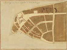
| History of New York City |
|---|
|
Lenape and New Netherland, to 1664 New Amsterdam British and Revolution, 1665–1783 Federal and early American, 1784–1854 Tammany and Consolidation, 1855–1897 (Civil War, 1861–1865) Early 20th century, 1898–1945 Post–World War II, 1946–1977 Modern and post-9/11, 1978–present |
| See also |
|
Transportation Timelines: NYC • Bronx • Brooklyn • Queens • Staten Island Category |
In April 1524, Florentine explorer Giovanni da Verrazzano, sailing in service of Francis I of France, became the first documented European to visit the area that would become New York City.[30] Verrazzano entered the tidal strait now known as The Narrows and named the land around Upper New York Harbor New Angoulême, in reference to the family name of King Francis I; he sailed far enough into the harbor to sight the Hudson River, and he named the Bay of Santa Margarita – what is now Upper New York Bay – after Marguerite de Navarre, the elder sister of the king.[31][32]
Manhattan was first mapped during a 1609 voyage of Henry Hudson.[33] Hudson came across Manhattan Island and the native people living there, and continued up the river that would later bear his name, the Hudson River.[34] Manhattan was first recorded in writing as Manna-hata, in the logbook of Robert Juet, an officer on the voyage.[35]
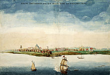
A permanent European presence in New Netherland began in 1624, with the founding of a Dutch fur trading settlement on Governors Island.[36] In 1625, construction was started on the citadel of Fort Amsterdam on Manhattan Island, later called New Amsterdam (Nieuw Amsterdam), in what is now Lower Manhattan.[37][38] The establishment of Fort Amsterdam is recognized as the birth of New York City.[39] In 1647, Peter Stuyvesant was appointed as the last Dutch Director-General of the colony.[40] New Amsterdam was formally incorporated as a city on February 2, 1653.[41] In 1664, English forces conquered New Netherland and renamed it "New York" after the English Duke of York and Albany, the future King James II.[42] In August 1673, the Dutch reconquered the colony, renaming it "New Orange", but permanently relinquished it back to England the following year under the terms of the Treaty of Westminster that ended the Third Anglo-Dutch War.[43][44]
American Revolution
[edit]
Manhattan was at the heart of the New York Campaign, a series of major battles in the early stages of the American Revolutionary War. The Continental Army was forced to abandon Manhattan after the Battle of Fort Washington on November 16, 1776.[46] The city, greatly damaged by the Great Fire of New York during the campaign, became the British military and political center of operations in North America for the remainder of the war.[47] British occupation lasted until November 25, 1783, when George Washington returned to Manhattan, a day celebrated as Evacuation Day, marking when the last British forces left the city.[48]
From January 11, 1785, until 1789, New York City was the fifth of five capitals of the United States under the Articles of Confederation, with the Continental Congress meeting at New York City Hall (then at Fraunces Tavern).[49] New York was the first capital under the newly enacted Constitution of the United States, from March 4, 1789, to August 12, 1790, at Federal Hall.[50] Federal Hall was where the United States Supreme Court met for the first time,[51] the United States Bill of Rights were drafted and ratified,[52] and where the Northwest Ordinance was adopted, establishing measures for admission to the Union of new states.[53]
19th century
[edit]New York grew as an economic center, first as a result of Alexander Hamilton's policies and practices as the first Secretary of the Treasury to expand the city's role as a center of commerce and industry.[54] By 1810, New York City, then confined to Manhattan, had surpassed Philadelphia as the most populous city in the United States.[55] The Commissioners' Plan of 1811 laid out the island of Manhattan in its familiar grid plan.[56] The city's role as an economic center grew with the opening of the Erie Canal in 1825, cutting transportation costs by 90% compared to road transport and connecting the Atlantic port to the vast agricultural markets of the Midwestern United States and Canada.[57][58][59]
Tammany Hall, a Democratic Party political machine, began to grow in influence with the support of many of the immigrant Irish, culminating in the election of the first Tammany mayor, Fernando Wood, in 1854.[60] Covering 840 acres (340 ha) in the center of the island, Central Park, which opened its first portions to the public in 1858, became the first landscaped public park in an American city.[61][62][63][64]
New York City played a complex role in the American Civil War. The city had strong commercial ties to the South, but anger around conscription, resentment against Lincoln's war policies and paranoia about free Blacks taking the jobs of poor immigrants[65] culminated in the three-day-long New York Draft Riots of July 1863, among the worst incidents of civil disorder in American history.[66] The rate of immigration from Europe grew steeply after the Civil War, and Manhattan became the first stop for millions seeking a new life in the United States, a role acknowledged by the dedication of the Statue of Liberty in 1886.[67][68] This immigration brought further social upheaval. In a city of tenements packed with poorly paid laborers from dozens of nations, the city became a hotbed of revolution (including anarchists and communists among others), syndicalism, racketeering, and unionization.[citation needed]
In 1883, the opening of the Brooklyn Bridge across the East River established a road connection to Brooklyn and the rest of Long Island.[69] In 1898, New York City consolidated with three neighboring counties to form "the City of Greater New York", and Manhattan was established as one of the five boroughs of New York City.[70][71] The Bronx remained part of New York County until 1914, when Bronx County was established.[72]
20th century
[edit]
The construction of the New York City Subway, which opened in 1904, helped bind the new city together,[73] as did the completion of the Williamsburg Bridge (1903) and Manhattan Bridge (1909) connecting to Brooklyn and the Queensboro Bridge (1909) connecting to Queens.[74] In the 1920s, Manhattan experienced large arrivals of African-Americans as part of the Great Migration from the southern United States, and the Harlem Renaissance,[75] part of a larger boom time in the Prohibition era that included new skyscrapers competing for the skyline, with the Woolworth Building (1913), 40 Wall Street (1930), Chrysler Building (1930) and the Empire State Building (1931) leapfrogging each other to take their place as the world's tallest building.[76] Manhattan's majority white ethnic group declined from 98.7% in 1900 to 58.3% by 1990.[77] On March 25, 1911, the Triangle Shirtwaist Factory fire in Greenwich Village killed 146 garment workers,[78] leading to overhauls of the city's fire department, building codes, and workplace safety regulations.[79] In 1912, about 20,000 workers, a quarter of them women, marched upon Washington Square Park to commemorate the fire. Many of the women wore fitted tucked-front blouses like those manufactured by the company, a clothing style that became the working woman's uniform and a symbol of women's liberation, reflecting the alliance of the labor and suffrage movements.[80]
Despite the Great Depression, some of the world's tallest skyscrapers were completed in Manhattan during the 1930s, including numerous Art Deco masterpieces that are still part of the city's skyline, most notably the Empire State Building, the Chrysler Building, and 30 Rockefeller Plaza.[81] A postwar economic boom led to the development of huge housing developments targeted at returning veterans, the largest being Stuyvesant Town–Peter Cooper Village, which opened in 1947.[82][83] The United Nations relocated to a new headquarters that was completed in 1952 along the East River.[84][85][86]
The Stonewall riots were a series of spontaneous, violent protests by members of the gay community against a police raid that took place in the early morning hours of June 28, 1969, at the Stonewall Inn in the Greenwich Village neighborhood of Lower Manhattan. They are widely considered to constitute the single most important event leading to the gay liberation movement[87][88] and the modern fight for LGBT rights.[89][90]
In the 1970s, job losses due to industrial restructuring caused New York City, including Manhattan, to suffer from economic problems and rising crime rates.[91] While a resurgence in the financial industry greatly improved the city's economic health in the 1980s, New York's crime rate continued to increase through the decade and into the beginning of the 1990s.[92] The 1980s saw a rebirth of Wall Street, and Manhattan reclaimed its role as the world's financial center, with Wall Street employment doubling from 1977 to 1987.[93] The 1980s also saw Manhattan at the heart of the AIDS crisis, with Greenwich Village at its epicenter.[94]
In the 1970s, Times Square and 42nd Street – with its sex shops, peep shows, and adult theaters, along with its sex trade, street crime, and public drug use – became emblematic of the city's decline, with a 1981 article in Rolling Stone magazine calling the stretch of West 42nd Street between 7th and 8th Avenues the "sleaziest block in America".[95] By the late 1990s, led by efforts by the city and the Walt Disney Company, the area had been revived as a center of tourism to the point where it was described by The New York Times as "arguably the most sought-after 13 acres of commercial property in the world."[96]
By the 1990s, crime rates began to drop dramatically[97][98] and the city once again became the destination of immigrants from around the world, joining with low interest rates and Wall Street bonus payments to fuel the growth of the real estate market.[99] Important new sectors, such as Silicon Alley, emerged in the Flatiron District, cementing technology as a key component of Manhattan's economy.[100]
The 1993 World Trade Center bombing, described by the FBI as "something of a deadly dress rehearsal for 9/11", was a terrorist attack in which six people were killed when a van bomb filled with explosives was detonated in a parking lot below the North Tower of the World Trade Center complex.[101]
21st century
[edit]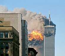
On September 11, 2001, the Twin Towers of the original World Trade Center were struck by hijacked aircraft and collapsed in the September 11 attacks launched by al-Qaeda terrorists. The collapse caused extensive damage to surrounding buildings and skyscrapers in Lower Manhattan, and resulted in the deaths of 2,606 of the 17,400 who had been in the buildings when the planes hit, in addition to those on the planes.[102] Since 2001, most of Lower Manhattan has been restored, although there has been controversy surrounding the rebuilding. In 2014, the new One World Trade Center, at 1,776 feet (541 m) measured to the top if its spire, became the tallest building in the Western Hemisphere[103] and is the world's seventh-tallest building (as of 2023).[104]
The Occupy Wall Street protests in Zuccotti Park in the Financial District of Lower Manhattan began on September 17, 2011, receiving global attention and spawning the Occupy movement against social and economic inequality worldwide.[105][106]
On October 29 and 30, 2012, Hurricane Sandy caused extensive destruction in the borough, ravaging portions of Lower Manhattan with record-high storm surge from New York Harbor,[107] severe flooding, and high winds, causing power outages for hundreds of thousands of city residents[108] and leading to gasoline shortages[109] and disruption of mass transit systems.[110][111][112][113] The storm and its profound impacts have prompted discussion of constructing seawalls and other coastal barriers around the shorelines of the borough and the metropolitan area to minimize the risk of destructive consequences from another such event in the future.[114]
On October 31, 2017, a terrorist drove a truck down a bike path alongside the West Side Highway in Lower Manhattan, killing eight.[115]
Geography
[edit]
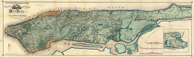
According to the United States Census Bureau, New York County has a total area of 33.6 square miles (87 km2), of which 22.8 square miles (59 km2) is land and 10.8 square miles (28 km2) (32%) is water.[1] The northern segment of Upper Manhattan represents a geographic panhandle. Manhattan Island is 22.7 square miles (59 km2) in area, 13.4 miles (21.6 km) long and 2.3 miles (3.7 km) wide, at its widest point, near 14th Street.[116]
The borough consists primarily of Manhattan Island, along with the Marble Hill neighborhood and several small islands, including Randalls Island and Wards Island and Roosevelt Island in the East River; and Governors Island and Liberty Island to the south in New York Harbor.[117]
Manhattan Island
[edit]Manhattan Island is loosely divided into Downtown (Lower Manhattan), Midtown (Midtown Manhattan), and Uptown (Upper Manhattan), with Fifth Avenue dividing Manhattan lengthwise into its East Side and West Side.[118] Manhattan Island is bounded by the Hudson River to the west and the East River to the east. To the north, the Harlem River divides Manhattan Island from the Bronx and the mainland United States. Early in the 19th century, land reclamation was used to expand Lower Manhattan from the natural Hudson shoreline at Greenwich Street to West Street.[119] When building the World Trade Center in 1968, 1.2 million cubic yards (920,000 m3) of material excavated from the site[120] was used to expand the Manhattan shoreline across West Street, creating Battery Park City.[121] Constructed on piers at a cost of $260 million, Little Island opened on the Hudson River in May 2021, connected to the western termini of 13th and 14th Streets by footbridges.[122]
Marble Hill
[edit]Marble Hill was part of the northern tip of Manhattan Island, but the Harlem River Ship Canal, dug in 1895 to better connect the Harlem and Hudson rivers, separated it from the remainder of Manhattan.[123] Before World War I, the section of the original Harlem River channel separating Marble Hill from the Bronx was filled in, and Marble Hill became part of the mainland.[124] After a May 1984 court ruling that Marble Hill was simultaneously part of the Borough of Manhattan (not the Borough of the Bronx) and part of Bronx County (not New York County),[125] the matter was definitively settled later that year when the New York Legislature overwhelmingly passed legislation declaring the neighborhood part of both New York County and the Borough of Manhattan.[126][127]
Smaller islands
[edit]
Within New York Harbor, there are three smaller islands:
- Ellis Island, shared with New Jersey[128]
- Governors Island[129]
- Liberty Island (administered by the National Park Service)[130]
Other smaller islands, in the East River, include (from north to south):
- Randalls and Wards Islands, joined by landfill
- Mill Rock
- Roosevelt Island, which has a population of 14,000, extends for 2 miles (3.2 km), and was renamed in 1973 from Welfare Island to honor President Franklin D. Roosevelt.[131]
- U Thant Island (legally Belmont Island)
Geology
[edit]The bedrock underlying much of Manhattan consists of three rock formations: Inwood marble, Fordham gneiss, and Manhattan schist, and is well suited for the foundations of Manhattan's skyscrapers.[132] It is part of the Manhattan Prong physiographic region.
Adjacent counties
[edit]Places adjacent to Manhattan | |
|---|---|
Climate
[edit]
Under the Köppen climate classification, New York City features both a humid subtropical climate (Cfa) and a humid continental climate (Dfa);[133] it is the northernmost major city on the North American continent with a humid subtropical climate. The city averages 234 days with at least some sunshine annually.[134]
Winters are cold and damp, and prevailing wind patterns that blow offshore temper the moderating effects of the Atlantic Ocean, yet the Atlantic and the partial shielding from colder air by the Appalachians keep the city warmer in the winter than inland North American cities at similar or lesser latitudes. The daily mean temperature in January, the area's coldest month, is 32.6 °F (0.3 °C);[135] temperatures usually drop to 10 °F (−12 °C) several times per winter,[135][136] and reach 60 °F (16 °C) several days in the coldest winter month.[135] Spring and autumn are unpredictable and can range from chilly to warm, although they are usually mild with low humidity. Summers are typically warm to hot and humid, with a daily mean temperature of 76.5 °F (24.7 °C) in July.[135] Nighttime conditions are often exacerbated by the urban heat island phenomenon, which causes heat absorbed during the day to be radiated back at night, raising temperatures by as much as 7 °F (4 °C) when winds are slow.[137] Daytime temperatures exceed 90 °F (32 °C) on average of 17 days each summer[138] and in some years exceed 100 °F (38 °C). Extreme temperatures have ranged from −15 °F (−26 °C), recorded on February 9, 1934, up to 106 °F (41 °C) on July 9, 1936.[138]
Manhattan receives 49.9 inches (1,270 mm) of precipitation annually, which is relatively evenly spread throughout the year. Average winter snowfall between 1981 and 2010 has been 25.8 inches (66 cm); this varies considerably from year to year.[138]
| Month | Jan | Feb | Mar | Apr | May | Jun | Jul | Aug | Sep | Oct | Nov | Dec | Year |
|---|---|---|---|---|---|---|---|---|---|---|---|---|---|
| Record high °F (°C) | 72 (22) |
78 (26) |
86 (30) |
96 (36) |
99 (37) |
101 (38) |
106 (41) |
104 (40) |
102 (39) |
94 (34) |
84 (29) |
75 (24) |
106 (41) |
| Mean maximum °F (°C) | 60.4 (15.8) |
60.7 (15.9) |
70.3 (21.3) |
82.9 (28.3) |
88.5 (31.4) |
92.1 (33.4) |
95.7 (35.4) |
93.4 (34.1) |
89.0 (31.7) |
79.7 (26.5) |
70.7 (21.5) |
62.9 (17.2) |
97.0 (36.1) |
| Mean daily maximum °F (°C) | 39.5 (4.2) |
42.2 (5.7) |
49.9 (9.9) |
61.8 (16.6) |
71.4 (21.9) |
79.7 (26.5) |
84.9 (29.4) |
83.3 (28.5) |
76.2 (24.6) |
64.5 (18.1) |
54.0 (12.2) |
44.3 (6.8) |
62.6 (17.0) |
| Daily mean °F (°C) | 33.7 (0.9) |
35.9 (2.2) |
42.8 (6.0) |
53.7 (12.1) |
63.2 (17.3) |
72.0 (22.2) |
77.5 (25.3) |
76.1 (24.5) |
69.2 (20.7) |
57.9 (14.4) |
48.0 (8.9) |
39.1 (3.9) |
55.8 (13.2) |
| Mean daily minimum °F (°C) | 27.9 (−2.3) |
29.5 (−1.4) |
35.8 (2.1) |
45.5 (7.5) |
55.0 (12.8) |
64.4 (18.0) |
70.1 (21.2) |
68.9 (20.5) |
62.3 (16.8) |
51.4 (10.8) |
42.0 (5.6) |
33.8 (1.0) |
48.9 (9.4) |
| Mean minimum °F (°C) | 9.8 (−12.3) |
12.7 (−10.7) |
19.7 (−6.8) |
32.8 (0.4) |
43.9 (6.6) |
52.7 (11.5) |
61.8 (16.6) |
60.3 (15.7) |
50.2 (10.1) |
38.4 (3.6) |
27.7 (−2.4) |
18.0 (−7.8) |
7.7 (−13.5) |
| Record low °F (°C) | −6 (−21) |
−15 (−26) |
3 (−16) |
12 (−11) |
32 (0) |
44 (7) |
52 (11) |
50 (10) |
39 (4) |
28 (−2) |
5 (−15) |
−13 (−25) |
−15 (−26) |
| Average precipitation inches (mm) | 3.64 (92) |
3.19 (81) |
4.29 (109) |
4.09 (104) |
3.96 (101) |
4.54 (115) |
4.60 (117) |
4.56 (116) |
4.31 (109) |
4.38 (111) |
3.58 (91) |
4.38 (111) |
49.52 (1,258) |
| Average snowfall inches (cm) | 8.8 (22) |
10.1 (26) |
5.0 (13) |
0.4 (1.0) |
0.0 (0.0) |
0.0 (0.0) |
0.0 (0.0) |
0.0 (0.0) |
0.0 (0.0) |
0.1 (0.25) |
0.5 (1.3) |
4.9 (12) |
29.8 (76) |
| Average precipitation days (≥ 0.01 in) | 10.8 | 10.0 | 11.1 | 11.4 | 11.5 | 11.2 | 10.5 | 10.0 | 8.8 | 9.5 | 9.2 | 11.4 | 125.4 |
| Average snowy days (≥ 0.1 in) | 3.7 | 3.2 | 2.0 | 0.2 | 0.0 | 0.0 | 0.0 | 0.0 | 0.0 | 0.0 | 0.2 | 2.1 | 11.4 |
| Average relative humidity (%) | 61.5 | 60.2 | 58.5 | 55.3 | 62.7 | 65.2 | 64.2 | 66.0 | 67.8 | 65.6 | 64.6 | 64.1 | 63.0 |
| Mean monthly sunshine hours | 162.7 | 163.1 | 212.5 | 225.6 | 256.6 | 257.3 | 268.2 | 268.2 | 219.3 | 211.2 | 151.0 | 139.0 | 2,534.7 |
| Percent possible sunshine | 54 | 55 | 57 | 57 | 57 | 57 | 59 | 63 | 59 | 61 | 51 | 48 | 57 |
| Source 1: NOAA[138][135][134] | |||||||||||||
| Source 2: Weather Atlas[140] | |||||||||||||
Neighborhoods
[edit]
Manhattan's many neighborhoods are not named according to any particular convention, nor do they have official boundaries. Some are geographical (the Upper East Side), or ethnically descriptive (Little Italy). Others are acronyms, such as TriBeCa (for "TRIangle BElow CAnal Street") or SoHo ("SOuth of HOuston"), NoLIta ("NOrth of Little ITAly"), and NoMad ("NOrth of MADison Square Park").[141][142][143][144][145] Harlem is a name from the Dutch colonial era after Haarlem, a city in the Netherlands.[146] Some have simple folkloric names, such as Hell's Kitchen, alongside their more official but lesser used title (in this case, Clinton).[147]
Some neighborhoods, such as SoHo, which is mixed use, are known for upscale shopping as well as residential use.[148] Others, such as Greenwich Village, the Lower East Side, Alphabet City and the East Village, have long been associated with the Bohemian subculture.[149][150][151] Chelsea is one of several Manhattan neighborhoods with large gay populations and has become a center of both the international art industry and New York's nightlife.[152] Chinatown has the highest concentration of people of Chinese descent outside of Asia.[153][154] Koreatown is roughly centered on 32nd Street between Fifth and Sixth Avenues.[155] Rose Hill features a growing number of Indian restaurants and spice shops along a stretch of Lexington Avenue between 25th and 30th Streets which has become known as Curry Hill.[156] Washington Heights in Uptown Manhattan is home to the largest Dominican immigrant community in the United States.[157] Harlem, also in Upper Manhattan, is the historical epicenter of African American culture.[158] Since 2010, a Little Australia has emerged and is growing in Nolita, Lower Manhattan.[159]
Manhattan has two central business districts, the Financial District at the southern tip of the island, and Midtown Manhattan. The term uptown also refers to the northern part of Manhattan above 72nd Street and downtown to the southern portion below 14th Street,[160] with Midtown covering the area in between, though definitions can be fluid. Fifth Avenue roughly bisects Manhattan Island and acts as the demarcation line for east/west designations.[160][161] South of Waverly Place, Fifth Avenue terminates and Broadway becomes the east/west demarcation line.[citation needed] In Manhattan, uptown means north and downtown means south.[162] This usage differs from that of most American cities, where downtown refers to the central business district.
Boroughscape
[edit]
Demographics
[edit]
As of the 2020 census, Manhattan's population had increased by 6.8% over the decade to 1,694,250, representing 19.2% of New York City's population of 8,804,194 and 8.4% of New York State's population of 20,201,230.[3] The population density of New York County was 70,450.8 inhabitants per square mile (27,201.2/km2) in 2022, the highest population density of any county in the United States and higher than the density of any individual U.S. city.[163][164] At the 2010 census, there were 1,585,873 people living in Manhattan, an increase of 3.2% from the 1,537,195 counted in the 2000 census.[165]
| Racial composition | 2020[167] | 2010[168] | 2000[169] | 1990[77] | 1950[77] | 1900[77] |
|---|---|---|---|---|---|---|
| White | 50.0% | 57.4% | 54.3% | 58.3% | 79.4% | 97.8% |
| —Non-Hispanic | 46.8% | 48% | 45.7% | 48.9% | n/a | n/a |
| Black or African American | 13.5% | 15.6% | 17.3% | 22.0% | 19.6% | 2.0% |
| Hispanic or Latino (of any race) | 23.8% | 25.4% | 27.1% | 26.0% | n/a | n/a |
| Asian | 13.1% | 11.3% | 9.4% | 7.4% | 0.8% | 0.3% |
Religion
[edit]In 2010, the largest organized religious group in Manhattan was the Archdiocese of New York, with 323,325 Catholics worshiping at 109 parishes, followed by 64,000 Orthodox Jews with 77 congregations, an estimated 42,545 Muslims with 21 congregations, 42,502 non-denominational adherents with 54 congregations, 26,178 TEC Episcopalians with 46 congregations, 25,048 ABC-USA Baptists with 41 congregations, 24,536 Reform Jews with 10 congregations, 23,982 Mahayana Buddhists with 35 congregations, 10,503 PC-USA Presbyterians with 30 congregations, and 10,268 RCA Presbyterians with 10 congregations. Altogether, 44.0% of the population was claimed as members by religious congregations, although members of historically African-American denominations were underrepresented due to incomplete information.[170] In 2014, Manhattan had 703 religious organizations, the seventeenth most out of all US counties.[171] There is a large Buddhist temple in Manhattan located at the foot of the Manhattan Bridge in Chinatown.[172]
Languages
[edit]As of 2015, 60.0% (927,650) of Manhattan residents, aged five and older, spoke only English at home, while 22.63% (350,112) spoke Spanish, 5.37% (83,013) Chinese, 2.21% (34,246) French, 0.85% (13,138) Korean, 0.72% (11,135) Russian, and 0.70% (10,766) Japanese. In total, 40.0% of Manhattan's population, aged five and older, spoke a language other than English at home.[173]
Landmarks and architecture
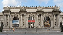
[edit]Points of interest on Manhattan Island include the American Museum of Natural History; the Battery; Broadway and the Theater District; Bryant Park; Central Park, Chinatown; the Chrysler Building; The Cloisters; Columbia University; Curry Hill; the Empire State Building; Flatiron Building; the Financial District (including the New York Stock Exchange Building; Wall Street; and the South Street Seaport); Grand Central Terminal; Greenwich Village (including New York University; Washington Square Arch; and Stonewall Inn); Harlem and Spanish Harlem; the High Line; Koreatown; Lincoln Center; Little Australia; Little Italy; Madison Square Garden; Museum Mile on Fifth Avenue (including the Metropolitan Museum of Art); Penn Station, Port Authority Bus Terminal; Rockefeller Center (including Radio City Music Hall); Times Square; and the World Trade Center (including the National September 11 Museum and One World Trade Center).
There are also numerous iconic bridges across rivers that connect to Manhattan Island, as well as an emerging number of supertall skyscrapers. The Statue of Liberty rests on Liberty Island, an exclave of Manhattan, and part of Ellis Island is also an exclave of Manhattan. The borough has many energy-efficient office buildings, such as the Hearst Tower, the rebuilt 7 World Trade Center,[174] and the Bank of America Tower—the first skyscraper designed to attain a Platinum LEED Certification.[175][176]

The skyscraper, which has shaped Manhattan's distinctive skyline, has been closely associated with New York City's identity since the end of the 19th century.[177] Structures such as the Equitable Building of 1915, which rises vertically forty stories from the sidewalk, prompted the passage of the 1916 Zoning Resolution, requiring new buildings to contain setbacks withdrawing progressively at a defined angle from the street as they rose, in order to preserve a view of the sky at street level.[178] Manhattan's skyline includes several buildings that are symbolic of New York, in particular the Chrysler Building[179]: 14 and the Empire State Building, which sees about 4 million visitors a year.[180]
In 1961, the struggling Pennsylvania Railroad unveiled plans to tear down the old Penn Station and replace it with a new Madison Square Garden and office building complex.[181] Organized protests were aimed at preserving the McKim, Mead & White-designed structure completed in 1910, widely considered a masterpiece of the Beaux-Arts style and one of the architectural jewels of New York City.[182] Despite these efforts, demolition of the structure began in October 1963.[183] The loss of Penn Station led directly to the enactment in 1965 of a local law establishing the New York City Landmarks Preservation Commission, which is responsible for preserving the "city's historic, aesthetic, and cultural heritage".[184] The historic preservation movement triggered by Penn Station's demise has been credited with the retention of some one million structures nationwide, including over 1,000 in New York City.[185] In 2017, a multibillion-dollar rebuilding plan was unveiled to restore the historic grandeur of Penn Station, in the process of upgrading the landmark's status as a critical transportation hub.[186]
The 700,000 sq ft (65,000 m2) Moynihan Train Hall, developed as a $1.6 billion renovation and expansion of Penn Station into the James A. Farley Building, the city's former main post office building, was opened in January 2021.[187]
National protected areas
[edit]- African Burial Ground National Monument
- Castle Clinton National Monument
- Federal Hall National Memorial
- General Grant National Memorial
- Governors Island National Monument
- Hamilton Grange National Memorial
- Lower East Side Tenement National Historic Site
- Statue of Liberty National Monument (part)
- Theodore Roosevelt Birthplace National Historic Site
Parkland
[edit]
Parkland covers a total of 2,659 acres (10.76 km2), accounting for 18.2% of the borough's land area; the 840-acre (3.4 km2) Central Park is the borough's largest park, comprising 31.6% of Manhattan's parkland.[188] Designed by Frederick Law Olmsted and Calvert Vaux, the park is anchored by the 12-acre (4.9 ha) Great Lawn[189] and offers extensive walking tracks, two ice-skating rinks, a wildlife sanctuary, and several lawns and sporting areas, as well as 21 playgrounds,[190] and a 6-mile (9.7 km) road from which automobile traffic has been banned since 2018.[191] While much of the park looks natural, it is almost entirely landscaped; the construction of Central Park in the 1850s was one of the era's most massive public works projects, with some 20,000 workers moving 5 million cubic yards (3.8 million cubic meters) of material to shape the topography and create the English-style pastoral landscape that Olmsted and Vaux sought.[192]
The remaining 70% of Manhattan's parkland includes 204 playgrounds, 251 Greenstreets, 371 basketball courts, and many other amenities.[193] The next-largest park in Manhattan, the Hudson River Park, stretches 4.5 miles (7.2 km) along the Hudson River and comprises 550 acres (220 ha).[194] Other major parks include:[188]
- Bowling Green
- Bryant Park
- City Hall Park
- DeWitt Clinton Park
- East River Greenway
- Fort Tryon Park
- Fort Washington Park
- Harlem River Park
- Rucker Park
- Imagination Playground
- Inwood Hill Park
- Isham Park
- J. Hood Wright Park
- Jackie Robinson Park
- Madison Square Park
- Marcus Garvey Park
- Morningside Park
- Randall's Island Park
- Riverside Park
- Sara D. Roosevelt Park
- Seward Park
- St. Nicholas Park
- Stuyvesant Square
- The Battery
- The High Line
- Thomas Jefferson Park
- Tompkins Square Park
- Union Square Park
- Washington Square Park
Economy
[edit]
Manhattan is the economic engine of New York City, with its 2.45 million workers drawn from the entire New York metropolitan area accounting for almost more than half of all jobs in New York City.[195] Manhattan's workforce is overwhelmingly focused on white collar professions. In 2010, Manhattan's daytime population was swelling to 3.94 million, with commuters adding a net 1.48 million people to the population, along with visitors, tourists, and commuting students. The commuter influx of 1.61 million workers coming into Manhattan was the largest of any county or city in the country.[196]
Manhattan had the highest per capita income, at $186,848 in 2022, among United States counties with more than 50,000 residents.[197] Based on census data for New York County for 2018–2022, the median household income was $99,880 and the poverty rate was 17.2%.[3] In the second quarter of 2023, Manhattan had an average weekly wage of $2,590, ranked fourth-highest among the nation's 360 largest counties.[195] Data for 2022 from the Census Bureau showed growing inequality, with those in the top 20% having an average household income of $545,549, more than 50 times higher than the $10,529 average income in the lowest 20% of households, the largest gap of any county in the country and "larger ... than in many developing countries",[198][199] with inequality growing steadily since 2010.[200] As of 2023[update], Manhattan's cost of living was the highest in the United States.[201]
Financial sector
[edit]
Manhattan's most important economic sector lies in its role as the headquarters for the U.S. financial industry, metonymously known as Wall Street. Manhattan is home to the New York Stock Exchange (NYSE), at 11 Wall Street in Lower Manhattan, and the Nasdaq, now located at 4 Times Square in Midtown Manhattan, representing the world's largest and second-largest stock exchanges, respectively, when measured both by overall share trading value and by total market capitalization of their listed companies in 2023.[20] The NYSE American (formerly the American Stock Exchange, AMEX), New York Board of Trade, and the New York Mercantile Exchange (NYMEX) are also located downtown.
Corporate sector
[edit]New York City is home to the most corporate headquarters of any city in the United States, the overwhelming majority based in Manhattan.[202] Manhattan had more than 520 million square feet (48 million square meters) of office space in 2022,[203] making it the largest office market in the United States; while Midtown Manhattan, with more than 400 million square feet (37 million square meters) is the largest central business district in the world.[204] Lower Manhattan is the third-largest U.S. central business district (following the Chicago Loop).[205][206] New York City's role as the top global center for the advertising industry is metonymously known as "Madison Avenue".[207]
Tech and biotech
[edit]
Manhattan has driven New York's status as a top-tier global high technology hub.[209][210] Silicon Alley, once a metonym for the sphere encompassing the metropolitan region's high tech industries,[211] is no longer a relevant moniker as the city's tech environment has expanded dramatically both in location and in its scope. New York City's current tech sphere encompasses a universal array of applications involving artificial intelligence, the internet, new media, financial technology (fintech) and cryptocurrency, biotechnology, game design, and other fields within information technology that are supported by its entrepreneurship ecosystem and venture capital investments. As of 2014[update], New York City hosted 300,000 employees in the tech sector.[212][213] In 2015, Silicon Alley generated over US$7.3 billion in venture capital investment,[214] most based in Manhattan, as well as in Brooklyn, Queens, and elsewhere in the region. High technology startup companies and employment are growing in Manhattan and across New York City, bolstered by the city's emergence as a global node of creativity and entrepreneurship,[214] social tolerance,[215] and environmental sustainability,[216][217] as well as New York's position as the leading Internet hub and telecommunications center in North America, including its vicinity to several transatlantic fiber optic trunk lines, the city's intellectual capital, and its extensive outdoor wireless connectivity.[218] Verizon Communications, headquartered at 140 West Street in Lower Manhattan, was at the final stages in 2014 of completing a US$3 billion fiberoptic telecommunications upgrade throughout New York City.[219]
The biotechnology sector is also growing in Manhattan based upon the city's strength in academic scientific research and public and commercial financial support. By mid-2014, Accelerator, a biotech investment firm, had raised more than US$30 million from investors, including Eli Lilly and Company, Pfizer, and Johnson & Johnson, for initial funding to create biotechnology startups at the Alexandria Center for Life Science, which encompasses more than 700,000 square feet (65,000 m2) on East 29th Street and promotes collaboration among scientists and entrepreneurs at the center and with nearby academic, medical, and research institutions. The New York City Economic Development Corporation's Early Stage Life Sciences Funding Initiative and venture capital partners, including Celgene, General Electric Ventures, and Eli Lilly, committed a minimum of US$100 million to help launch 15 to 20 ventures in life sciences and biotechnology.[220] In 2011, Mayor Michael R. Bloomberg had announced his choice of Cornell University and Technion-Israel Institute of Technology to build a US$2 billion graduate school of applied sciences on Roosevelt Island, Manhattan, with the goal of transforming New York City into the world's premier technology capital.[221][222][needs update]
Tourism
[edit]
Tourism is vital to Manhattan's economy, and the landmarks of Manhattan are the focus of New York City's tourists, with a record 66.6 million visiting the city in 2019, bringing in $47.4 billion in tourism revenue. Visitor numbers dropped by two-thirds in 2020 during the COVID-19 pandemic, climbing back to 63.3 million visitors in 2023.[223][224]
According to The Broadway League, shows on Broadway sold approximately US$1.54 billion worth of tickets in the 2022–2023 and the 2023–2024 seasons with attendance of approximately 12.3 million each.[225]
Real estate
[edit]Real estate is a major force driving Manhattan's economy. Manhattan has perennially been home to some of the world's most valuable real estate, including the Time Warner Center, which had the highest-listed market value in the city in 2006 at US$1.1 billion,[226] to be subsequently surpassed in October 2014 by the Waldorf Astoria New York, which became the most expensive hotel ever sold after being purchased by the Anbang Insurance Group, based in China, for US$1.95 billion.[227] When 450 Park Avenue was sold on July 2, 2007, for US$510 million, about US$1,589 per square foot (US$17,104/m²), it broke the barely month-old record for an American office building of US$1,476 per square foot (US$15,887/m²) based on the sale of 660 Madison Avenue.[228] In 2014, Manhattan was home to six of the top ten zip codes in the United States by median housing price.[229] In 2019, the most expensive home sale ever in the United States occurred in Manhattan, at a selling price of US$238 million, for a 24,000-square-foot (2,200 m2) penthouse apartment overlooking Central Park,[230] while Central Park Tower, topped out at 1,550 feet (472 m) in 2019, is the world's tallest residential building, followed globally in height by 111 West 57th Street and 432 Park Avenue, both also located in Midtown Manhattan.
Media
[edit]Manhattan has been described as the media capital of the world.[231][232] A significant array of media outlets and their journalists report about international, American, business, entertainment, and New York metropolitan area–related matters from Manhattan.
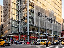
Manhattan is served by the major New York City daily news publications, including The New York Times, which has won the most Pulitzer Prizes for journalism[233] and is considered the U.S. media's newspaper of record;[234] the New York Daily News; and the New York Post, which are all headquartered in the borough. The nation's largest newspaper by circulation, The Wall Street Journal, is also based in Manhattan.[235] Other daily newspapers include AM New York and The Villager. The New York Amsterdam News, based in Harlem, is one of the leading Black-owned weekly newspapers in the United States. The Village Voice, historically the largest alternative newspaper in the United States, announced in 2017 that it would cease publication of its print edition and convert to a fully digital venture.[236]
The television industry developed in Manhattan and is a significant employer in the borough's economy. The four major American broadcast networks, ABC, CBS, NBC, and Fox,[237] as well as Univision, are all headquartered in Manhattan, as are many cable channels, including CNN, MSNBC, MTV, Fox News, HBO, and Comedy Central. In 1971, WLIB became New York City's first Black-owned radio station[238] and began broadcasts geared toward the African-American community in 1949.[239] WQHT, also known as Hot 97, claims to be the premier hip-hop station in the United States.[240] WNYC, broadcasting on both an AM and FM signal, has the largest public radio audience in the nation and is the most-listened to commercial or non-commercial radio station in Manhattan.[241] WBAI, owned by the non-profit Pacifica Foundation, broadcasts eclectic music, as well as political news, talk and opinion from a left-leaning viewpoint.[242]
The oldest public-access television cable TV channel in the United States is the Manhattan Neighborhood Network, founded in 1971, offers eclectic local programming that ranges from a jazz hour to discussions of labor issues to foreign language and religious programming.[243] NY1, Charter Communications's local news channel, is known for its beat coverage of City Hall and state politics.[244]
Education
[edit]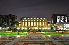


Education in Manhattan is provided by a vast number of public and private institutions. Non-charter public schools in the borough are operated by the New York City Department of Education,[247] the largest public school system in the United States. Charter schools include Success Academy Harlem 1 through 5, Success Academy Upper West, and Public Prep.
Several notable New York City public high schools are located in Manhattan, including A. Philip Randolph Campus High School, Beacon High School, Stuyvesant High School, Fiorello H. LaGuardia High School, High School of Fashion Industries, Eleanor Roosevelt High School, NYC Lab School, Manhattan Center for Science and Mathematics, Hunter College High School, and High School for Math, Science and Engineering at City College. Bard High School Early College, a hybrid school created by Bard College, serves students from around the city.
Many private preparatory schools are also situated in Manhattan, including the Upper East Side's Brearley School, Dalton School, Browning School, Spence School, Chapin School, Nightingale-Bamford School, Convent of the Sacred Heart, Hewitt School, Saint David's School, Loyola School, and Regis High School. The Upper West Side is home to the Collegiate School and Trinity School. The borough is also home to Manhattan Country School, Trevor Day School, Xavier High School and the United Nations International School.
Based on data from the 2011–2015 American Community Survey, 59.9% of Manhattan residents over age 25 have a bachelor's degree.[248] As of 2005, about 60% of residents were college graduates and some 25% had earned advanced degrees, giving Manhattan one of the nation's densest concentrations of highly educated people.[249]
Manhattan has various colleges and universities, including Columbia University (and its affiliate Barnard College), Cooper Union, Marymount Manhattan College, New York Institute of Technology, New York University (NYU), The Juilliard School, Pace University, Berkeley College, The New School, Yeshiva University, and a campus of Fordham University. Other schools include Bank Street College of Education, Boricua College, Jewish Theological Seminary of America, Manhattan School of Music, Metropolitan College of New York, Parsons School of Design, School of Visual Arts, Touro College, and Union Theological Seminary. Several other private institutions maintain a Manhattan presence, among them Mercy College, St. John's University, Adelphi University, The King's College, and Pratt Institute. Cornell Tech, part of Cornell University, is developing on Roosevelt Island.
The City University of New York (CUNY), the municipal college system of New York City, is the largest urban university system in the United States, serving more than 226,000 degree students and a roughly equal number of adult, continuing and professional education students.[250] A third of college graduates in New York City graduate from CUNY, with the institution enrolling about half of all college students in New York City. CUNY senior colleges located in Manhattan include: Baruch College, City College of New York, Hunter College, John Jay College of Criminal Justice and William E. Macaulay Honors College; graduate studies and doctorate-granting institutions are Craig Newmark Graduate School of Journalism at the City University of New York, CUNY Graduate Center, CUNY Graduate School of Public Health & Health Policy, CUNY School of Labor and Urban Studies and CUNY School of Professional Studies.[251][252] The only CUNY community college located in Manhattan is the Borough of Manhattan Community College.[253] The State University of New York is represented by the Fashion Institute of Technology, State University of New York State College of Optometry, and Stony Brook University – Manhattan.[254]
Manhattan is a world center for training and education in medicine and the life sciences.[255] The city as a whole receives the second-highest amount of annual funding from the National Institutes of Health among all U.S. cities,[256] the bulk of which goes to Manhattan's research institutions, including Memorial Sloan-Kettering Cancer Center, Rockefeller University, Mount Sinai School of Medicine, Columbia University College of Physicians and Surgeons, Weill Cornell Medical College, and New York University School of Medicine.
Manhattan is served by the New York Public Library, which has the largest collection of any public library system in the country.[257] The five units of the Central Library—Mid-Manhattan Library, 53rd Street Library, the New York Public Library for the Performing Arts, Andrew Heiskell Braille and Talking Book Library, and the Science, Industry and Business Library—are all located in Manhattan.[258] More than 35 other branch libraries are located in the borough.[259]
Culture
[edit]This section may contain an excessive amount of intricate detail that may interest only a particular audience. (August 2024) |

Manhattan is the borough most closely associated with New York City by non-residents; residents within the New York City metropolitan area, including New York City's boroughs outside Manhattan, will often describe a trip to Manhattan as "going to the City".[260] Poet Walt Whitman characterized the streets of Manhattan as being traversed by "hurrying, feverish, electric crowds".[261]
Manhattan has been the scene of many important global and American cultural movements. The Harlem Renaissance in the 1920s established the African-American literary canon in the United States and introduced writers Langston Hughes and Zora Neale Hurston. Manhattan's visual art scene in the 1950s and 1960s was a center of the pop art movement, which gave birth to such giants as Jasper Johns and Roy Lichtenstein. The downtown pop art movement of the late 1970s included artist Andy Warhol and clubs like Serendipity 3 and Studio 54, where he socialized.
Broadway theatre is considered the highest professional form of theatre in the United States. Plays and musicals are staged in one of the 39 larger professional theatres with at least 500 seats, almost all in and around Times Square. Off-Broadway theatres feature productions in venues with 100–500 seats.[262][263] Lincoln Center for the Performing Arts, anchoring Lincoln Square on the Upper West Side of Manhattan, is home to 12 influential arts organizations, including the Metropolitan Opera, New York Philharmonic, and New York City Ballet, as well as the Vivian Beaumont Theater, the Juilliard School, Jazz at Lincoln Center, and Alice Tully Hall. Performance artists displaying diverse skills are ubiquitous on the streets of Manhattan.
Manhattan is also home to some of the most extensive art collections in the world, both contemporary and classical art, including the Metropolitan Museum of Art, the Museum of Modern Art (MoMA), the Frick Collection, the Whitney Museum of American Art, and the Frank Lloyd Wright-designed Guggenheim Museum. The Upper East Side has many art galleries,[264][265] and the downtown neighborhood of Chelsea is known for its more than 200 art galleries that are home to modern art from both upcoming and established artists.[266][267] Many of the world's most lucrative art auctions are held in Manhattan.[268][269]


Manhattan is the epicenter of LGBT culture and the central node of the LGBTQ+ sociopolitical ecosystem.[272] The borough is widely acclaimed as the cradle of the modern LGBTQ rights movement, with its inception at the 1969 Stonewall Riots.[88][273][274][89][275] Brian Silverman, the author of Frommer's New York City from $90 a Day, wrote the city has "one of the world's largest, loudest, and most powerful LGBT communities", and "Gay and lesbian culture is as much a part of New York's basic identity as yellow cabs, high-rise buildings, and Broadway theatre"—[276] radiating from this central hub, as LGBT travel guide Queer in the World states, "The fabulosity of Gay New York is unrivaled on Earth, and queer culture seeps into every corner of its five boroughs".[277] Multiple gay villages have developed, spanning the length of the borough from the Lower East Side, East Village, and Greenwich Village, through Chelsea and Hell's Kitchen, uptown to Morningside Heights.
The annual NYC Pride March (or gay pride parade) traverses southward down Fifth Avenue and ends at Greenwich Village; the Manhattan parade is the largest pride parade in the world, attracting tens of thousands of participants and millions of sidewalk spectators each June.[270][271] Stonewall 50 – WorldPride NYC 2019 was the largest international Pride celebration in history, produced by Heritage of Pride. The events were in partnership with the I ❤ NY program's LGBT division, commemorating the 50th anniversary of the Stonewall uprising, with 150,000 participants and five million spectators attending in Manhattan.[278]
The borough is represented in several prominent idioms. The phrase New York minute is meant to convey an extremely short time such as an instant,[279] sometimes in hyperbolic form, as in "perhaps faster than you would believe is possible," referring to the rapid pace of life in Manhattan.[280][281] The expression "melting pot" was first popularly coined to describe the densely populated immigrant neighborhoods on the Lower East Side in Israel Zangwill's play The Melting Pot, which was an adaptation of William Shakespeare's Romeo and Juliet set in New York City in 1908.[282] The iconic Flatiron Building is said to have been the source of the phrase "23 skidoo" or scram, from what cops would shout at men who tried to get glimpses of women's dresses being blown up by the winds created by the triangular building.[283] The "Big Apple" dates back to the 1920s, when a reporter heard the term used by New Orleans stable-hands to refer to New York City's horse racetracks and named his racing column "Around The Big Apple". Jazz musicians adopted the term to refer to the city as the world's jazz capital, and a 1970s ad campaign by the New York Convention and Visitors Bureau helped popularize the term.[284]


Manhattan is well known for its street parades, which celebrate a broad array of themes, including holidays, nationalities, human rights, and major league sports team championship victories. The majority of higher profile parades in New York City are held in Manhattan. The primary orientation of the annual street parades is typically from north to south, marching along major avenues. The annual Macy's Thanksgiving Day Parade is the world's largest parade,[285] beginning alongside Central Park and processing southward to the flagship Macy's Herald Square store;[288] the parade is viewed on telecasts worldwide and draws millions of spectators in person.[285]
Other notable parades including the world's oldest St. Patrick's Day Parade, held annually in March since 1762,[289][290] the Greenwich Village Halloween Parade in October,[291] and numerous parades commemorating the independence days of many nations.[292] Ticker-tape parades celebrating sporting championships won as well as other national accomplishments march northward on Broadway from Bowling Green to City Hall Park in Lower Manhattan, along the Canyon of Heroes.[293] New York Fashion Week, held at various locations in Manhattan, is a high-profile semiannual event featuring models displaying the latest wardrobes created by prominent fashion designers worldwide in advance of these fashions proceeding to the retail marketplace.
Sports
[edit]
Manhattan is home to the NBA's New York Knicks and the NHL's New York Rangers, both of which play their home games at Madison Square Garden, the only major professional sports arena in the borough.[294] The Garden was also home to the WNBA's New York Liberty through the 2017 season, but that team's primary home is now the Barclays Center in Brooklyn. The New York Jets proposed a West Side Stadium for their home field, but the proposal was defeated in June 2005, and they now play at MetLife Stadium in East Rutherford, New Jersey.[295]
Manhattan does not currently host a professional baseball franchise. The original New York Giants played primarily in the various incarnations of the Polo Grounds from their inception in 1883 until they headed to California with the Brooklyn Dodgers after the 1957 season.[296] The New York Yankees began their franchise as the Highlanders, named for Hilltop Park, where they played from their creation in 1903 until 1912.[297] The team moved to the Polo Grounds with the 1913 season, where they were officially christened the New York Yankees, remaining there until they moved across the Harlem River in 1923 to Yankee Stadium.[298] The New York Mets played in the Polo Grounds in 1962 and 1963, their first two seasons, before Shea Stadium was completed in 1964.[299] After the Mets departed, the Polo Grounds was demolished in April 1964.[300][301]
The first national college-level basketball championship, the National Invitation Tournament, was held in New York in 1938 and remains in the city.[302] The New York Knicks started play in 1946 as one of the National Basketball Association's original teams, playing their first home games at the 69th Regiment Armory, before making Madison Square Garden their permanent home.[303] The New York Liberty of the WNBA shared the Garden with the Knicks from their creation in 1997 as one of the league's original eight teams through the 2017 season,[304] after which the team moved nearly all of its home schedule to White Plains, New York.[305] Rucker Park in Harlem is a playground court, famed for its streetball style of play, where many NBA athletes have played in the summer league.[306]
Although both of New York City's football teams play today in MetLife Stadium in East Rutherford, New Jersey, both teams started out playing in the Polo Grounds. The New York Giants played side-by-side with their baseball namesakes from the time they entered the National Football League in 1925, until crossing over to Yankee Stadium in 1956.[307] The New York Jets, originally known as the Titans of New York, started out in 1960 at the Polo Grounds, before joining the Mets in Queens at Shea Stadium in 1964.[308]
The New York Rangers of the National Hockey League have played in the various locations of Madison Square Garden since the team's founding in the 1926–1927 season. The Rangers were predated by the New York Americans, who started play in the Garden the previous season, lasting until the team folded after the 1941–1942 NHL season, a season it played in the Garden as the Brooklyn Americans.[309]
The New York Cosmos of the North American Soccer League played their home games at Downing Stadium for two seasons, starting in 1974. The playing pitch and facilities at Downing Stadium were in unsatisfactory condition, however, and as the team's popularity grew they too left for Yankee Stadium, and then Giants Stadium. The stadium was demolished in 2002 to make way for the $45 million, 4,754-seat Icahn Stadium.[310][311]
Government
[edit]
Since New York City's consolidation in 1898, Manhattan has been governed by the New York City Charter; its 1989 revision provided for a strong mayor–council system.[312] The centralized New York City government is responsible for public education, correctional institutions, libraries, public safety, recreational facilities, sanitation, water supply, and welfare services in Manhattan.
The office of Borough President was created in the consolidation of 1898 to balance centralization with local authority. Each borough president had a powerful administrative role derived from having a vote on the New York City Board of Estimate, which was responsible for creating and approving the city's budget and proposals for land use. In 1989, the US Supreme Court declared the Board of Estimate unconstitutional because Brooklyn, the most populous borough, had no greater effective representation on the Board than Staten Island, the least populous borough, a violation of the Equal Protection Clause.[313] Since 1990, the largely powerless Borough President has acted as an advocate for the borough at the mayoral agencies, the City Council, the New York state government, and corporations.[citation needed] Manhattan's current Borough President is Mark Levine, elected as a Democrat in November 2021.
Alvin Bragg, a Democrat, is the District Attorney of New York County. Manhattan has ten City Council members, the third largest contingent among the five boroughs. It also has twelve administrative districts, each served by a local Community Board. Community Boards are representative bodies that field complaints and serve as advocates for local residents.
As the host of the United Nations, the borough is home to the world's largest international consular corps, comprising 105 consulates, consulates general and honorary consulates.[314] It is also the home of New York City Hall, the seat of New York City government housing the Mayor of New York City and the New York City Council. The mayor's staff and thirteen municipal agencies are located in the nearby Manhattan Municipal Building, completed in 1914, one of the largest governmental buildings in the world.[315]
Politics
[edit]
| Year | Republican / Whig | Democratic | Third party(ies) | |||
|---|---|---|---|---|---|---|
| No. | % | No. | % | No. | % | |
| 2020 | 85,185 | 12.21% | 603,040 | 86.42% | 9,588 | 1.37% |
| 2016 | 64,930 | 9.71% | 579,013 | 86.56% | 24,997 | 3.74% |
| 2012 | 89,559 | 14.92% | 502,674 | 83.74% | 8,058 | 1.34% |
| 2008 | 89,949 | 13.47% | 572,370 | 85.70% | 5,566 | 0.83% |
| 2004 | 107,405 | 16.73% | 526,765 | 82.06% | 7,781 | 1.21% |
| 2000 | 82,113 | 14.38% | 454,523 | 79.60% | 34,370 | 6.02% |
| 1996 | 67,839 | 13.76% | 394,131 | 79.96% | 30,929 | 6.27% |
| 1992 | 84,501 | 15.88% | 416,142 | 78.20% | 31,475 | 5.92% |
| 1988 | 115,927 | 22.89% | 385,675 | 76.14% | 4,949 | 0.98% |
| 1984 | 144,281 | 27.39% | 379,521 | 72.06% | 2,869 | 0.54% |
| 1980 | 115,911 | 26.23% | 275,742 | 62.40% | 50,245 | 11.37% |
| 1976 | 117,702 | 25.54% | 337,438 | 73.22% | 5,698 | 1.24% |
| 1972 | 178,515 | 33.38% | 354,326 | 66.25% | 2,022 | 0.38% |
| 1968 | 135,458 | 25.59% | 370,806 | 70.04% | 23,128 | 4.37% |
| 1964 | 120,125 | 19.20% | 503,848 | 80.52% | 1,746 | 0.28% |
| 1960 | 217,271 | 34.19% | 414,902 | 65.28% | 3,394 | 0.53% |
| 1956 | 300,004 | 44.26% | 377,856 | 55.74% | 0 | 0.00% |
| 1952 | 300,284 | 39.30% | 446,727 | 58.47% | 16,974 | 2.22% |
| 1948 | 241,752 | 32.75% | 380,310 | 51.51% | 116,208 | 15.74% |
| 1944 | 258,650 | 33.47% | 509,263 | 65.90% | 4,864 | 0.63% |
| 1940 | 292,480 | 37.59% | 478,153 | 61.45% | 7,466 | 0.96% |
| 1936 | 174,299 | 24.51% | 517,134 | 72.71% | 19,820 | 2.79% |
| 1932 | 157,014 | 27.78% | 378,077 | 66.89% | 30,114 | 5.33% |
| 1928 | 186,396 | 35.74% | 317,227 | 60.82% | 17,935 | 3.44% |
| 1924 | 190,871 | 41.20% | 183,249 | 39.55% | 89,206 | 19.25% |
| 1920 | 275,013 | 59.22% | 135,249 | 29.12% | 54,158 | 11.66% |
| 1916 | 113,254 | 42.65% | 139,547 | 52.55% | 12,759 | 4.80% |
| 1912 | 63,107 | 18.15% | 166,157 | 47.79% | 118,391 | 34.05% |
| 1908 | 154,958 | 44.71% | 160,261 | 46.24% | 31,393 | 9.06% |
| 1904 | 155,003 | 42.11% | 189,712 | 51.54% | 23,357 | 6.35% |
| 1900 | 153,001 | 44.16% | 181,786 | 52.47% | 11,700 | 3.38% |
| 1896 | 156,359 | 50.73% | 135,624 | 44.00% | 16,249 | 5.27% |
| 1892 | 98,967 | 34.73% | 175,267 | 61.50% | 10,750 | 3.77% |
| 1888 | 106,922 | 39.20% | 162,735 | 59.67% | 3,076 | 1.13% |
| 1884 | 90,095 | 39.54% | 133,222 | 58.47% | 4,530 | 1.99% |
| 1880 | 81,730 | 39.79% | 123,015 | 59.90% | 636 | 0.31% |
| 1876 | 58,561 | 34.17% | 112,530 | 65.66% | 289 | 0.17% |
| 1872 | 54,676 | 41.27% | 77,814 | 58.73% | 0 | 0.00% |
| 1868 | 47,738 | 30.59% | 108,316 | 69.41% | 0 | 0.00% |
| 1864 | 36,681 | 33.23% | 73,709 | 66.77% | 0 | 0.00% |
| 1860 | 33,290 | 34.83% | 62,293 | 65.17% | 0 | 0.00% |
| 1856 | 17,771 | 22.32% | 41,913 | 52.65% | 19,922 | 25.03% |
| 1852 | 23,124 | 39.98% | 34,280 | 59.27% | 436 | 0.75% |
| 1848 | 29,070 | 54.51% | 18,973 | 35.57% | 5,290 | 9.92% |
| 1844 | 26,385 | 48.15% | 28,296 | 51.64% | 117 | 0.21% |
| 1840 | 20,958 | 48.69% | 21,936 | 50.96% | 153 | 0.36% |
| 1836 | 16,348 | 48.42% | 17,417 | 51.58% | 0 | 0.00% |
| 1832 | 12,506 | 40.97% | 18,020 | 59.03% | 0 | 0.00% |
| 1828 | 9,638 | 38.44% | 15,435 | 61.56% | 0 | 0.00% |
The Democratic Party holds most public offices. Registered Republicans are a minority in the borough, constituting 9.88% of the electorate as of April 2016[update]. Registered Republicans are more than 20% of the electorate only in the neighborhoods of the Upper East Side and the Financial District as of 2016[update]. Democrats accounted for 68.41% of those registered to vote, while 17.94% of voters were unaffiliated.[319][320]
As of 2023, three Democrats represented Manhattan in the United States House of Representatives.[321]
- Dan Goldman (first elected in 2022) represents New York's 10th congressional district, which includes Lower Manhattan, as well as a portion of Brooklyn.
- Jerry Nadler (first elected in 1992) represents New York's 12th congressional district, which includes the Upper West Side, Upper East Side, and Midtown Manhattan.
- Adriano Espaillat (first elected in 2016) represents New York's 13th congressional district, which includes the Upper Manhattan, as well as part of the northwest Bronx.
Federal offices
[edit]The United States Postal Service operates post offices in Manhattan. The James Farley Post Office in Midtown Manhattan is New York City's main post office.[322] Both the United States District Court for the Southern District of New York and United States Court of Appeals for the Second Circuit are located in Lower Manhattan's Foley Square, and the U.S. Attorney and other federal offices and agencies maintain locations in that area.
Crime and public safety
[edit]Starting in the mid-19th century, the United States became a magnet for immigrants seeking to escape poverty in their home countries. After arriving in New York, many new arrivals ended up living in squalor in the slums of the Five Points neighborhood, an area between Broadway and the Bowery, northeast of New York City Hall. By the 1820s, the area was home to many gambling dens and brothels, and was known as a dangerous place to go. In 1842, Charles Dickens visited the area and was appalled at the horrendous living conditions he had seen.[323] The predominantly Irish Five Points Gang was one of the country's first major organized crime entities.
As Italian immigration grew in the early 20th century many joined ethnic gangs, including Al Capone, who got his start in crime with the Five Points Gang.[324] The Mafia (also known as Cosa Nostra) first developed in the mid-19th century in Sicily and spread to the US East Coast during the late 19th century following waves of Sicilian and Southern Italian emigration. Lucky Luciano established Cosa Nostra in Manhattan, forming alliances with other criminal enterprises, including the Jewish mob, led by Meyer Lansky, the leading Jewish gangster of that period.[325] From 1920 to 1933, Prohibition helped create a thriving black market in liquor, upon which the Mafia was quick to capitalize.[325]
New York City as a whole experienced a sharp increase in crime during the post-war period.[326] The murder rate in Manhattan hit an all-time high of 42 murders per 100,000 residents in 1979.[327] Manhattan retained the highest murder rate in the city until 1985 when it was surpassed by the Bronx.[327] Most serious violent crime has been historically concentrated in Upper Manhattan and the Lower East Side, though robbery in particular was a major quality of life concern throughout the borough. Through the 1990s and 2000s, levels of violent crime in Manhattan plummeted to levels not seen since the 1950s,[328] with murders in Manhattan dropping from 503 in 1990, at the citywide peak, to 78 in 2022, a decline of 84%.[329]
Today crime rates in most of Lower Manhattan, Midtown, the Upper East Side, and the Upper West Side are consistent with other major city centers in the United States. However, crime rates remain high in the Upper Manhattan neighborhoods of East Harlem, Harlem, Washington Heights, Inwood, and New York City Housing Authority developments across the borough, despite significant reductions. After the start of the COVID-19 pandemic in March 2020, there had been an increase in violent crime, particularly in Upper Manhattan.[330] Mirroring a nationwide trend, rates of shootings and violent crimes in 2023 declined from their peaks during the pandemic.[331][332][333]
Housing
[edit]
The rise of immigration near the turn of the 20th century left major portions of Manhattan, especially the Lower East Side, densely packed with recent arrivals, crammed into unhealthy and unsanitary housing. Tenements were usually five stories high, constructed on the then-typical 25 by 100 feet (7.6 by 30.5 m) lots, with "cockroach landlords" exploiting the new immigrants.[334][335] By 1929, a new housing code effectively ended construction of tenements, though some survive today on the East Side of the borough.[335] Conversely, there were also areas with luxury apartment developments, the first of which was the Dakota on the Upper West Side.[336]
Manhattan offers a wide array of private housing, as well as public housing, which is administered by the New York City Housing Authority (NYCHA). Affordable rental and co-operative housing units throughout the borough were created under the Mitchell–Lama Housing Program.[337] There were 923,302 housing units in 2022[3] at an average density of 40,745 units per square mile (15,732/km2). As of 2003[update], only 24.3% of Manhattan residents lived in owner-occupied housing, the second-lowest rate of all counties in the nation, after the Bronx.[338] Public housing administered by NYCHA accounts for nearly 100,000 residents in more than 50,000 units in 2023.[339] Completed in 1935, the First Houses in the East Village were one of the country's first publicly-funded low-income housing projects.[340][341] At $2,024 in 2022, Manhattan has the highest average cost for rent of any county in the US, although a lower percentage of annual income than in several other American cities.[342]
Manhattan's real estate market for luxury housing continues to be among the most expensive in the world,[343] and Manhattan residential property continues to have the highest sale price per square foot in the United States.[19] Manhattan's apartments cost $1,773 per square foot ($19,080/m2), compared to San Francisco housing at $1,185 per square foot ($12,760/m2), Boston housing at $751 per square foot ($8,080/m2), and Los Angeles housing at $451 per square foot ($4,850/m2).[344] As of the fourth quarter of 2021, the median value of homes in Manhattan was $1,306,208, second highest among US counties.[345]
Infrastructure
[edit]Transportation
[edit]This section may contain an excessive amount of intricate detail that may interest only a particular audience. (August 2023) |
Public transportation
[edit]


Manhattan is unique in the U.S. for intense use of public transportation and lack of private car ownership. While 88% of Americans nationwide drive to their jobs, with only 5% using public transport, mass transit is the dominant form of travel for residents of Manhattan, with 72% of borough residents using public transport to get to work, while only 18% drove.[346][347] According to the 2000 United States Census, 77.5% of Manhattan households do not own a car.[348] In 2008, Mayor Michael Bloomberg proposed a congestion pricing system to regulate entering Manhattan south of 60th Street, but the state legislature rejected the proposal.[349]
The New York City Subway, the largest subway system in the world by number of stations, is the primary means of travel within the city, linking every borough except Staten Island. There are 151 subway stations in Manhattan, out of the 472 stations.[350] A second subway, the PATH system, connects six stations in Manhattan to northern New Jersey. Passengers pay fares with pay-per-ride MetroCards, which are valid on all city buses and subways, as well as on PATH trains.[351][352] Commuter rail services operating to and from Manhattan are the Long Island Rail Road (LIRR), which connects Manhattan and other New York City boroughs to Long Island; the Metro-North Railroad, which connects Manhattan to Upstate New York and Southwestern Connecticut; and NJ Transit trains, which run to various points in New Jersey.
The US$11.1 billion East Side Access project, which brings LIRR trains to Grand Central Terminal, opened in 2023; this project utilized a pre-existing train tunnel beneath the East River, connecting the East Side of Manhattan with Long Island City, Queens.[353][354] Four multi-billion-dollar projects were completed in the mid-2010s: the $1.4 billion Fulton Center in November 2014,[355] the $2.4 billion 7 Subway Extension in September 2015,[356] the $4 billion World Trade Center Transportation Hub in March 2016,[357][358] and Phase 1 of the $4.5 billion Second Avenue Subway in January 2017.[359][360]
MTA New York City Transit offers a wide variety of local buses within Manhattan under the brand New York City Bus. An extensive network of express bus routes serves commuters and other travelers heading into Manhattan.[361] The bus system served 784 million passengers citywide in 2011, placing the bus system's ridership as the highest in the nation, and more than double the ridership of the second-place Los Angeles system.[362]
The Roosevelt Island Tramway, one of two commuter cable car systems in North America, takes commuters between Roosevelt Island and Manhattan in less than five minutes, and has been serving the island since 1978.[363][364]
The Staten Island Ferry, which runs 24 hours a day, 365 days a year, annually carries over 21 million passengers on the 5.2-mile (8.4 km) run between Manhattan and Staten Island. Each weekday, five vessels transport about 65,000 passengers on 109 boat trips.[365][366] The ferry has been fare-free since 1997.[367] In February 2015, Mayor Bill de Blasio announced that the city government would begin NYC Ferry to extend ferry transportation to traditionally underserved communities in the city.[368][369] The first routes of NYC Ferry opened in 2017.[370][371] All of the system's routes have termini in Manhattan, and the Lower East Side and Soundview routes also have intermediate stops on the East River.[372]
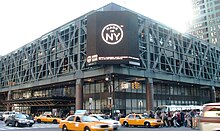
The metro region's commuter rail lines converge at Penn Station and Grand Central Terminal, on the west and east sides of Midtown Manhattan, respectively. They are the two busiest rail stations in the United States. About one-third of users of mass transit and two-thirds of railway passengers in the country live in New York and its suburbs.[375] Amtrak provides inter-city passenger rail service from Penn Station to Boston, Philadelphia, Baltimore, and Washington, D.C.; Upstate New York and New England; cross-Canadian border service to Toronto and Montreal; and destinations in the Southern and Midwestern United States.
The Port Authority Bus Terminal is the city's main intercity bus terminal and the world's busiest bus station. It serves 250,000 passengers on 7,000 buses each workday in a 1950 building designed to accommodate 60,000 daily passengers. A 2021 plan announced by the Port Authority would spend $10 billion to expand capacity and modernize the facility.[374][376][373] In 2024, the Port Authority announced plans for a new terminal that would be completed by 2032 and include a pair of office buildings to defray the costs of the project.[377]
Major highways
[edit]
Taxis
[edit]New York's iconic yellow taxicabs, which number 13,087 citywide and must have a medallion authorizing the pickup of street hails, are ubiquitous in the borough.[378] Private vehicle for hire companies provide significant competition for taxicabs.[379]
Bicycles
[edit]According to the government of New York City, Manhattan had 19,676 bicycle commuters in 2017, roughly doubling from its total of 9,613 in 2012.[380]
Streets and roads
[edit]
The Commissioners' Plan of 1811 called for twelve numbered "avenues" running north and south roughly parallel to the Hudson River, each 100 feet (30 m) wide, with First Avenue on the east side and Twelfth Avenue on the west side.[56][381] There are several intermittent avenues east of First Avenue, including four additional lettered avenues running from Avenue A eastward to Avenue D in an area now known as Alphabet City.[382] The numbered streets in Manhattan run east–west, and are generally 60 feet (18 m) wide, with about 200 feet (61 m) between streets.[56] The address algorithm of Manhattan is used to estimate the closest east–west cross street for building numbers on north–south avenues.[383]
According to the original Commissioner's Plan, there were 155 numbered crosstown streets,[384] but later the grid was extended up to the northernmost corner of Manhattan Island, where the last numbered street is 220th Street, though the grid continues to 228th Street in the borough's Marble Hill neighborhood.[385][386] Fifteen crosstown streets were designated as 100 feet (30 m) wide, including 34th, 42nd, 57th and 125th Streets,[387] which became some of the borough's most significant transportation and shopping venues. Broadway, following the route of a Native American trail, is the most notable of many exceptions to the grid, starting at Bowling Green in Lower Manhattan and continuing north for 13 miles (21 km) into the Bronx.[388] In much of Midtown Manhattan, Broadway runs at a diagonal to the grid, creating major named intersections at Union Square, Madison Square, Herald Square, Times Square, and Columbus Circle.[389][390]
"Crosstown streets" refers primarily to major east-west streets connecting Manhattan's East Side and West Side. The trip is notoriously frustrating for drivers because of heavy congestion on narrow local streets; absence of express roads other than the Trans-Manhattan Expressway at the far north end of Manhattan Island; and restricted to very limited crosstown automobile travel within Central Park. Proposals to build highways traversing the island through Manhattan's densest neighborhoods, namely the Mid-Manhattan Expressway across 34th Street and the Lower Manhattan Expressway through SoHo, failed in the 1960s.[391][392] In New York City, all turns at red lights are illegal unless a sign permitting such maneuvers is present, significantly shaping traffic patterns in Manhattan.[393]
Another consequence of the strict grid plan of most of Manhattan, and the grid's skew of approximately 28.9 degrees, is a phenomenon sometimes referred to as Manhattanhenge (by analogy with Stonehenge).[394] On May 28 and July 12, the sunset is aligned with the street grid lines, with the result that the sun is visible at or near the western horizon from street level.[394][395] A similar phenomenon occurs with the sunrise on the eastern horizon on December 5 and January 8.[396]
The FDR Drive and Harlem River Drive, both designed by controversial New York master planner Robert Moses,[397] comprise a single, long limited-access parkway skirting the east side of Manhattan along the East River and Harlem River south of Dyckman Street. The Henry Hudson Parkway is the corresponding parkway on the West Side north of 57th Street.
Bridges, tunnels, and ferries
[edit]
Being primarily an island, Manhattan is linked to New York City's outer boroughs by bridges. Manhattan has fixed highway connections with New Jersey to its west by way of the George Washington Bridge, the Holland Tunnel, and the Lincoln Tunnel, and to three of the four other New York City boroughs—the Bronx to the northeast, and Brooklyn and Queens (both on Long Island) to the east and south. Its only direct connection with the fifth New York City borough, Staten Island, is the free Staten Island Ferry across New York Harbor, located near Battery Park at Manhattan's southern tip. It is also possible to travel on land to Staten Island by way of Brooklyn, via the Verrazzano-Narrows Bridge.
The 14-lane George Washington Bridge, the world's busiest motor vehicle bridge,[398][399] connects Washington Heights, in Upper Manhattan to Bergen County in New Jersey.[400] There are numerous bridges to the Bronx across the Harlem River, and five (listed north to south)—the Triborough (known officially as the Robert F. Kennedy Bridge), Ed Koch Queensboro (also known as the 59th Street Bridge), Williamsburg, Manhattan, and Brooklyn Bridges—that cross the East River to connect Manhattan to Long Island.[401]
Several tunnels also link Manhattan Island to New York City's outer boroughs and New Jersey. The Lincoln Tunnel, which carries 120,000 vehicles a day under the Hudson River between New Jersey and Midtown Manhattan, is the busiest vehicular tunnel in the world.[402] The tunnel was built instead of a bridge to allow unfettered passage of large passenger and cargo ships that sail through New York Harbor and up the Hudson River to Manhattan's piers. The Holland Tunnel, connecting Lower Manhattan to Jersey City, New Jersey, was the world's first mechanically ventilated vehicular tunnel.[403] The Queens–Midtown Tunnel, built to relieve congestion on the bridges connecting Manhattan with Queens and Brooklyn, was the largest non-federal project in its time when it was completed in 1940;[404] President Franklin D. Roosevelt was the first person to drive through it.[405] The Brooklyn–Battery Tunnel runs underneath Battery Park and connects the Financial District at the southern tip of Manhattan to Red Hook in Brooklyn.
Several ferry services operate between New Jersey and Manhattan.[406] These ferries mainly serve midtown, Battery Park City, and Wall Street.
Heliports
[edit]Manhattan has three public heliports: the East 34th Street Heliport (also known as the Atlantic Metro-port), owned by New York City and run by the New York City Economic Development Corporation (NYCEDC); the Port Authority Downtown Manhattan/Wall Street Heliport, owned by the Port Authority of New York and New Jersey and run by the NYCEDC; and the West 30th Street Heliport, owned by the Hudson River Park Trust.[407]
Utilities
[edit]Gas and electric service is provided by Consolidated Edison. Manhattan witnessed the doubling of its natural gas supply when a new gas pipeline opened on November 1, 2013.[408] Con Edison operates the world's largest district steam system, which consists of 105 miles (169 km) of steam pipes, providing steam for heating, hot water, and air conditioning[409] by some 1,800 Manhattan customers.[410] Cable service is provided by Time Warner Cable and telephone service is provided by Verizon Communications, although AT&T is available as well.
The New York City Department of Sanitation is responsible for garbage removal.[411] The bulk of the city's trash is disposed at mega-dumps in Pennsylvania, Virginia, South Carolina, and Ohio (via transfer stations in New Jersey, Brooklyn and Queens) since the 2001 closure of the Fresh Kills Landfill on Staten Island.[412] A small amount of trash processed at transfer sites in New Jersey is sometimes incinerated at waste-to-energy facilities.
New York City has the largest clean-air diesel-hybrid and compressed natural gas bus fleet, which also operates in Manhattan, in the country. It also has some of the first hybrid taxis, most of which operate in Manhattan.[413]
Health care
[edit]There are many hospitals in Manhattan, including two of the 25 largest in the United States (as of 2017):[414]
- Bellevue Hospital
- Lenox Hill Hospital
- Lower Manhattan Hospital
- Metropolitan Hospital Center
- Mount Sinai Beth Israel Hospital
- Mount Sinai Hospital
- NewYork–Presbyterian Hospital
- NYC Health + Hospitals/Harlem
- NYU Langone Medical Center
Water purity and availability
[edit]New York City is supplied with drinking water by the protected Catskill Mountains watershed.[415] As a result of the watershed's integrity and undisturbed natural water filtration system, New York is one of only four major cities in the US with a majority of drinking water pure enough not to require purification by water treatment plants.[416] The Croton Watershed north of the city is undergoing construction of a US$3.2 billion water purification plant to augment New York City's water supply by an estimated 290 million gallons daily, representing a greater than 20% addition to the city's current availability of water.[417] Water comes to Manhattan through the tunnels 1 and 2, and in the future through Tunnel No. 3, begun in 1970.[418]
See also
[edit]- History of New York City
- List of Manhattan neighborhoods
- List of people from Manhattan
- Manhattanhenge
- Manhattanization
- Manhattoe
- National Register of Historic Places listings in Manhattan
- Sawing-off of Manhattan Island
- Timeline of New York City
Notes
[edit]- ^ Area codes 718, 347, and 929 are used in Marble Hill.
- ^ Mean monthly maxima and minima (i.e. the expected highest and lowest temperature readings at any point during the year or given month) calculated based on data at said location from 1991 to 2020.
- ^ Official weather observations for Central Park were conducted at the Arsenal at Fifth Avenue and 64th Street from 1869 to 1919, and at Belvedere Castle since 1919.[139]
- ^ The presidential election results for the years 1876–1912 are not strictly comparable with the earlier and later ones because New York County included the West Bronx after 1874 and all of what is now the Borough of the Bronx (Bronx County, New York) from 1895 until The Bronx became a separate borough in 1914.
References
[edit]Citations
[edit]- ^ Jump up to: a b 2010 Census Gazetteer Files: New York County Subdivisions Archived June 16, 2019, at the Wayback Machine, United States Census Bureau. Accessed June 19, 2017.
- ^ Manhattan High Point
- ^ Jump up to: a b c d e f g QuickFacts New York; New York city, New York; New York County, New York, United States Census Bureau. Accessed January 5, 2024.
- ^ Moynihan, Colin. "F.Y.I." Archived April 17, 2020, at the Wayback Machine, The New York Times, September 19, 1999. Accessed December 17, 2019. "There are well-known names for inhabitants of four boroughs: Manhattanites, Brooklynites, Bronxites and Staten Islanders. But what are residents of Queens called?"
- ^ "Gross Domestic Product by County and Metropolitan Area, 2022" (PDF). www.bea.gov. Bureau of Economic Analysis.
- ^ "World Urban Areas" (PDF). Demographia. April 2018. Retrieved April 27, 2018.
- ^ "A Nation challenged: in New York; New York Carries On, but Test of Its Grit Has Just Begun" Archived March 24, 2020, at the Wayback Machine, The New York Times, October 11, 2001. Accessed November 20, 2016. "A roaring void has been created in the financial center of the world."
- ^ Sorrentino, Christopher (September 16, 2007). "When He Was Seventeen". The New York Times. Retrieved December 22, 2007.
In 1980, there were still the remains of the various downtown revolutions that had reinvigorated New York's music and art scenes and kept Manhattan in the position it had occupied since the 1940s as the cultural center of the world.
- ^ Michael P. Ventura (April 6, 2010). "Manhattan May Be the Media Capital of the World, But Not For iPad Users". DNAinfo. Archived from the original on August 4, 2017. Retrieved June 11, 2017.
- ^ Dawn Ennis (May 24, 2017). "ABC will broadcast New York's pride parade live for the first time". LGBTQ Nation. Archived from the original on July 28, 2017. Retrieved June 4, 2017.
- ^ Jump up to: a b Burrows, Edwin G.; Wallace, Mike (1998). Gotham : a history of New York City to 1898. Mike Wallace. Oxford: Oxford University Press. pp. 6–7. ISBN 978-0-585-36462-9. OCLC 47011419.
- ^ "KINGSTON Discover 300 Years of New York History DUTCH COLONIES". National Park Service, U.S. Department of the Interior. Archived from the original on November 23, 2008. Retrieved April 7, 2018.
- ^ "The Nine Capitals of the United States". United States Senate. Archived from the original on March 20, 2016. Retrieved April 7, 2018.
- ^ "Statue of Liberty". World Heritage. UNESCO World Heritage Centre 1992–2011. Archived from the original on August 28, 2012. Retrieved April 7, 2018.
- ^ Michael M. Grynbaum (May 24, 2012). "The Reporters of City Hall Return to Their Old Perch". The New York Times. Archived from the original on June 25, 2017. Retrieved December 5, 2013.
- ^ "Workforce Diversity The Stonewall Inn, National Historic Landmark National Register Number: 99000562". National Park Service, U.S. Department of the Interior. Archived from the original on March 6, 2016. Retrieved July 2, 2013.
- ^ "Obama inaugural speech references Stonewall gay-rights riots". North Jersey Media Group Inc. January 21, 2013. Archived from the original on May 30, 2013. Retrieved July 2, 2013.
- ^ "2020 Census Urban Areas Facts (2020)". United States Census Bureau. Retrieved January 12, 2024.
- ^ Jump up to: a b Manhattan, NY Homes for Sale Archived August 15, 2018, at the Wayback Machine, Redfin. Accessed January 31, 2018.
- ^ Jump up to: a b Neufeld, Dorothy. "Mapped: The Largest Stock Exchanges in the World", Virtual Capitalist, October 18, 2023. Accessed December 26, 2023.
- ^ Jump up to: a b Ann Shields (November 10, 2014). "The World's 50 Most Visited Tourist Attractions – No. 3: Times Square, New York City – Annual Visitors: 50,000,000". Travel+Lesiure. Archived from the original on July 21, 2015. Retrieved July 12, 2015.
No. 3 Times Square, ... No. 4 (tie) Central Park, ... No. 10 Grand Central Terminal, New York City
- ^ Michael Kimmelman (September 30, 2016). "Penn Station Reborn". The New York Times. Retrieved August 3, 2022.
- ^ Sarah Waxman. "The History of New York's Chinatown". Mediabridge Infosystems, Inc. Retrieved January 12, 2024.
Manhattan's Chinatown, the largest Chinatown in the United States and the site of the largest concentration of Chinese in the Western Hemisphere, is located on the Lower East Side.
- ^ "New York's Fifth Avenue Retains its Top Ranking as the World's Most Expensive Retail Destination". Cushman & Wakefield. November 20, 2023. Retrieved July 31, 2024.
- ^ "Buildings in New York City". Council on Tall Buildings and Urban Habitat. Archived from the original on July 17, 2011. Retrieved June 8, 2011.
- ^ Magazine, Smithsonian. "The True Native New Yorkers Can Never Truly Reclaim Their Homeland". Smithsonian Magazine. Retrieved June 29, 2022.
- ^ Benchley, Nathaniel. "The $24 Swindle" American Heritage, 1959, Vol. 11, Issue 1. Accessed January 5, 2024.
- ^ Broadway, Society of Architectural Historians. Accessed November 30, 2023. "Predating the Commissioners' Plan of 1811, Broadway was initially a Native American trading trail running the length of Manhattan. Various indigenous peoples living on the island—including Lenni Lenape, Delaware Lenape, and Wickquasgeck—used the route, known as the Wickquasgeck Trail, to exchange goods with each other. Following Dutch settlement in 1609 and the establishment of Fort Amsterdam in lower Manhattan, the Wickquasgeck Trail's southern endpoint became a site for trading between the indigenous peoples and the European colonists."
- ^ Goddard, Ives (2010). "The Origin and Meaning of the Name "Manhattan"". New York History. 91 (4): 277–293. hdl:10088/16790. ISSN 0146-437X – via Smithsonian Research Online.
- ^ Giovanni da Verrazzano, Mariners' Museum and Park. Accessed December 24, 2023. "Verrazzano sailed onward, continuing his search for the Northwest Passage. In mid-April 1524, Verrazzano and his crew became the first known Europeans to sail into New York Bay. Once again they were greeted peacefully by the Native Americans and treated well."
- ^ R. J. Knecht: Renaissance Warrior and Patron: The Reign of Francis I; p. 372. Cambridge University Press (1996) ISBN 0-521-57885-X
- ^ Seymour I. Schwartz: The Mismapping of America. p. 42; The University of Rochester Press (2008) ISBN 978-1-58046-302-7
- ^ Rankin, Rebecca B.; Cleveland Rodgers (1948). New York: the World's Capital City, Its Development and Contributions to Progress. Harper.
- ^ "Henry Hudson and His Exploration" Archived January 18, 2012, at the Wayback Machine Scientific American, September 25, 1909. Accessed May 1, 2007. "This was a vain hope however, and the conviction must finally have come to the heart of the intrepid adventurer that once again he was foiled in his repeated quest for the northwest passage ... On the following day the Half Moon let go her anchor inside of Sandy Hook. The week was spent in exploring the bay with a shallop, or small boat, and "they found a good entrance between two headlands" (the Narrows) "and thus entered on the 12th of September into as fine a river as can be found""
- ^ Juet, Robert (2006) [1625]. "Juet's Journal of Hudson's 1609 Voyage, from the 1625 Edition of Purchas His Pilgrimes". The New York Times. Translated by Brea Barthel. p. 16. Archived from the original on July 3, 2016. Retrieved May 11, 2020.
- ^ History, Governor's Island. Accessed December 24, 2023. "The Dutch West India Company first arrived to New Amsterdam and opted to set up camp on the small, 70-acre Island rather than brave the wilderness that lay across the water on the island that would later be known as Manhattan."
- ^ Dutch Colonies Archived May 19, 2010, at the Wayback Machine, National Park Service. Accessed May 19, 2007. "Sponsored by the West India Company, 30 families arrived in North America in 1624, establishing a settlement on present-day Manhattan."
- ^ GovIsland Park-to-Tolerance: through Broad Awareness and Conscious Vigilance Archived August 24, 2019, at the Wayback Machine, Tolerance Park. Accessed November 20, 2016. See Legislative Resolutions Senate No. 5476 and Assembly No. 2708.
- ^ City Seal and Flag Archived April 28, 2015, at the Wayback Machine, New York City. Accessed November 20, 2016. "Date: Beneath the horizontal laurel branch the date 1625, being the year of the establishment of New Amsterdam."
- ^ Journal of New Netherland 1647. Written in the Years 1641, 1642, 1643, 1644, 1645, and 1646., Library of Congress. Accessed August 6, 2023. "The West India Company removed Kieft from his post in 1647 and replaced him with Peter Stuyvesant, the last director-general of New Netherland before the colony was taken over by the English in 1664."
- ^ About the Council Archived February 12, 2016, at the Wayback Machine, New York City Council. Accessed May 18, 2007.
- ^ New Netherlands Becomes New York, University of Houston Digital History. Accessed January 3, 2024. "In 1664, the English sent a fleet to seize New Netherlands, which surrendered without a fight. The English renamed the colony New York, after James, the Duke of York, who had received a charter to the territory from his brother King Charles II."
- ^ Scheltema, Gajus and Westerhuijs, Heleen (eds.),Exploring Historic Dutch New York. Museum of the City of New York/Dover Publications, New York (2011). ISBN 978-0-486-48637-6
- ^ "History of New York City - 1600s NYC", History 101 NYC. Accessed January 3, 2024. "1673: A pivotal moment in New York City's history when Dutch forces briefly reclaimed it during the Third Anglo-Dutch War. The city, captured by the English in 1664 and renamed New York, was temporarily dubbed New Orange in honor of William of Orange.... 1674: The Treaty of Westminster, signed in February, officially concluded the Third Anglo-Dutch War. This treaty marked a crucial turn in colonial history, transferring New York permanently to English control."
- ^ "The Inauguration of George Washington, 1789". Eyewitness to History. Ibis Communications, Inc. 2005. Archived from the original on January 10, 2013. Retrieved January 6, 2013.
- ^ Fort Washington, American Battlefield Trust. Accessed November 30, 2023. "Fought on November 16, 1776 on the island of Manhattan, the Battle of Fort Washington was the final devastating chapter in General Washington's disastrous New York Campaign.... At 3:00 P.M., after a fruitless attempt to gain gentler surrender terms for his men, Magaw surrendered Fort Washington and its 2,800 surviving defenders to the British."
- ^ Fort Washington Park Archived July 8, 2009, at the Wayback Machine, New York City Department of Parks and Recreation. Accessed May 18, 2007.
- ^ Axelson, Erik Peter."Happy Evacuation Day" Archived October 5, 2008, at the Wayback Machine, New York City Department of Parks and Recreation, November 23, 2005. Accessed December 24, 2023. "During the Revolutionary War, New York City was occupied by British forces (from September 15, 1776 to November 25, 1783). For generations afterward, New Yorkers celebrated its repatriation from the British as Evacuation Day."
- ^ "January Highlight: Superintending Independence, Part 1", Harvard University Declaration Resources Project, January 4, 2017. Accessed December 24, 2023. "From January 11, 1785 through 1789, the Congress of the Confederation met in New York City, at City Hall (which later became Federal Hall) and at Fraunces Tavern."
- ^ The Nine Capitals of the United States Archived March 20, 2016, at the Wayback Machine. United States Senate Historical Office. Accessed June 9, 2005. Based on Fortenbaugh, Robert, The Nine Capitals of the United States, York, Pennsylvania: Maple Press, 1948...
- ^ "Birthplace of American Government". National Park Service. Archived from the original on September 12, 2014. Retrieved September 21, 2014.
- ^ Lynch, Jack. "Debating the Bill of Rights". Colonial Williamsburg Foundation. Archived from the original on July 5, 2014. Retrieved September 21, 2014.
- ^ History & Culture: Federal Hall National Memorial, National Park Service. Accessed November 30, 2023. "After the American Revolution, the Continental Congress met at City Hall and, in 1787, adopted the Northwest Ordinance, establishing procedures for creating new states."
- ^ Historic New York, American Experience. Accessed December 24, 2023. "But New York's enormous Revolutionary War debt had the federal government hovering on the brink of bankruptcy, so Alexander Hamilton struck a momentous deal with Thomas Jefferson.... Alexander Hamilton's extraordinary early vision helped invent the economic future not only for his adoptive city, but also for the rest of the United States. Although the country was 90% agrarian, Hamilton understood that the future lay in manufacturing. As the first Secretary of the Treasury in New York City in 1789, he mapped out a blueprint for a new kind of nation – one based not on plantations and slave labor, but on commerce, manufacturing, and immigrant toil."
- ^ Dunlap, David W. "Last Time New York Had Just 27 House Seats? The City Was on the Rise", Archived September 24, 2014, at the Wayback Machine The New York Times, December 1, 2010. Accessed December 24, 2023. "Even as war with Britain seemed more and more inevitable, however, New York spent much of 1810 — boisterously and confidently — developing into the American metropolis. New York, just as I pictured it. This was the year New York surpassed Philadelphia in population to become the largest city of the young republic, with 96,373 people; 94,687 of whom were free, 1,686 of whom were enslaved."
- ^ Jump up to: a b c The Commissioners' Plan, 1811, Museum of the City of New York. Accessed December 1, 2023. "The avenues are 100 feet wide, the standard cross street is 60 feet, and major cross streets are 100 feet.... The second pattern derives from block dimensions: all blocks are 200 feet north to south, but their dimensions east to west vary, diminishing in width from the center of the island to the shorelines."
- ^ Bridges, William (1811). Map of the City of New York and Island of Manhattan with Explanatory Remarks and References.
- ^ Lankevich (1998), pp. 67–68.
- ^ Canal History, New York State Canal Corporation. Accessed January 3, 2024. "In 1825, Governor Dewitt Clinton officially opened the Erie Canal as he sailed the packet boat Seneca Chief along the Canal from Buffalo to Albany.... The explosion of trade prophesied by Governor Clinton began, spurred by freight rates from Buffalo to New York of $10 per ton by Canal, compared with $100 per ton by road.... The Erie Canal played an integral role in the transformation of New York City into the nation's leading port, a national identity that continues to be reflected in many songs, legends and artwork today."
- ^ "Sachems & Sinners An Informal History Of Tammany Hall", Time, August 22, 1955. Accessed December 1, 2023. "Born in Philadelphia, Wood went to New York to become an actor, but turned instead to politics and rose to become the first real Boss of Tammany Hall. In 1854 he became Mayor of New York City."
- ^ Central Park Opens: 1858, New York City Landmarks Preservation Commission. Accessed December 24, 2023. ""
- ^ Blair, Cynthia. "1858: Central Park Opens", Newsday. Accessed May 29, 2007. "Between 1853 and 1856, city commissioners purchased more than 700 acres (280 ha) from 59th Street to 106th Street between Fifth and Eighth Avenues to create Central Park, the nation's first public park [sic] as well as its first landscaped park." In actuality, Boston Common is the nation's first public park. Boston Common Archived December 26, 2014, at the Wayback Machine, Thefreedomtrail.org.
- ^ Rybczynski, Witold. "Olmsted's Triumph" Archived December 26, 2015, at the Wayback Machine, Smithsonian (magazine), July 2003. Accessed November 20, 2016. "By 1876, landscape designer Frederick Law Olmsted and architect Calvert Vaux had transformed the swampy, treeless 50 blocks between Harlem and midtown Manhattan into the first landscaped park in the United States."
- ^ Morgan, David. "New York's Central Park", CBS News, July 21, 2019. Accessed December 24, 2023. "America's first major landscaped public park, Manhattan's 840-acre Central Park welcomes more than 37 million visitors every year."
- ^ Harris, Leslie M. "The New York City Draft Riots of 1863" excerpted from In the Shadow of Slavery: African Americans in New York City, 1626–1863 Archived June 29, 2011, at the Wayback Machine, University of Chicago Press. Accessed November 20, 2016.
- ^ Ward, Geoffrey C. "Gangs of New York" Archived July 16, 2019, at the Wayback Machine, a review of Paradise Alley by Kevin Baker, The New York Times, October 6, 2002. Accessed June 30, 2009. "The New York draft riots remain the worst civil disturbance in American history: according to the historian Adrian Cook, 119 people are known to have been killed, mostly rioters or onlookers who got too close when federal troops, brought back from the battlefield to restore order, started shooting."
- ^ Statue of Liberty Archived March 16, 2016, at the Wayback Machine, National Park Service. Accessed May 17, 2007.
- ^ "New Jerseyans' Claim To Liberty I. Rejected" Archived March 28, 2019, at the Wayback Machine, The New York Times, October 6, 1987. Accessed June 30, 2009. "The Supreme Court today refused to strip the Statue of Liberty of its status as a New Yorker. The Court, without comment, turned away a move by a two New Jerseyans to claim jurisdiction over the landmark for their state."
- ^ Brooklyn Bridge, New York City Department of Transportation. Accessed November 30, 2023. "The Brooklyn Bridge was designed by John A. Roebling. Construction began in 1869 and was completed in 1883.... The Brooklyn Bridge connects the boroughs of Manhattan and Brooklyn by spanning the East River."
- ^ Consolidation of the Five-Borough City: 1898, New York City Landmarks Preservation Commission. Accessed November 30, 2023. "On January 1, 1898, the separate jurisdictions of New York (Manhattan), Brooklyn, the Bronx, Queens, and Staten Island joined together to form a single metropolis: the City of Greater New York. Movements for consolidation had been considered as far back as 1820, but by the end of the 19th century proponents were claiming that a single metropolitan jurisdiction stretching over five boroughs would run more efficiently and cement New York as the economic and cultural capital of the nation."
- ^ McFadden, Robert D. "Rockets' Red Glare Marked Birth of Merged City in 1898", The New York Times, January 1, 1973. Accessed November 30, 2023.
- ^ "Birth of a Borough", A Walk Through the Bronx. Accessed January 3, 2024. "After consolidation in 1898, the twenty-third and twenty-fourth wards became the borough of the Bronx, which with Manhattan remained part of New York County (the other boroughs were already separate counties).... It was not until 1912, however, that the state legislature established the County of the Bronx as the sixty-second county in the state, effective January 1, 1914."
- ^ Opening ceremonies, New York subway, Oct. 27, 1904, Library of Congress. Accessed December 1, 2023.
- ^ Dim, Joan Marans. "New York's Golden Age of Bridges", Fordham University Press, 2012. ISBN 978-0-8232-5308-1. Accessed December 4, 2023. "The Williamsburg followed in 1903, the Queensboro (renamed the Ed Koch Queensboro Bridge) and the Manhattan in 1909, the George Washington in 1931, the Triborough (renamed the Robert F. Kennedy Bridge) in 1936, the Bronx-Whitestone in 1939, the Throgs Neck in 1961, and the Verrazano-Narrows in 1964."
- ^ A New African American Identity: The Harlem Renaissance, National Museum of African American History and Culture. Accessed December 1, 2023.
- ^ Barr, Jason M. "Why Doesn't New York Construct the World's Tallest Building Anymore?", Building the Skyline, December 23, 2020. Accessed December 4, 2023. "Generation II was the twentieth century before World War I. This crop included the Singer Building (1908, 674 feet, 205 meters, 41 stories), the Metropolitan Life Tower (1909, 700 feet, 210 meters, 50 stories), and the Woolworth Building (1913, 792 feet, 241 meters, 55 stories).... Left to Right: Bank of Manhattan Building (1930), Chrysler Building (1930), Empire State Building (1931)."
- ^ Jump up to: a b c d e Gibson, Campbell; and Jung, Kay. Historical Census Statistics On Population Totals By Race, 1790 to 1990, and By Hispanic Origin, 1970 to 1990, For Large Cities And Other Urban Places In The United States, United States Census Bureau, February 2005. Accessed December 27, 2023.
- ^ The Triangle Shirtwaist Factory Fire, Occupational Safety and Health Administration. Accessed December 1, 2023. "One hundred years ago on March 25, fire spread through the cramped Triangle Waist Company garment factory on the 8th, 9th and 10th floors of the Asch Building in lower Manhattan. Workers in the factory, many of whom were young women recently arrived from Europe, had little time or opportunity to escape. The rapidly spreading fire killed 146 workers."
- ^ Markel, Howard. "How the Triangle Shirtwaist Factory fire transformed labor laws and protected workers' health", PBS NewsHour, March 31, 2021. Accessed December 4, 2023. "Activists kept their memory alive by lobbying their local and state leaders to do something in the name of building and worker safety and health. Three months later, John Alden Dix, then the governor of New York, signed a law empowering the Factory Investigating Committee, which resulted in eight more laws covering fire safety, factory inspection, and sanitation and employment rules for women and children. The following year, 1912, activists and legislators in New York State enacted another 25 laws that transformed its labor protections among the most progressive in the nation."
- ^ The Triangle Factory Fire Archived May 12, 2012, at the Wayback Machine, Cornell University School of Industrial and Labor Relations. Accessed April 25, 2007.
- ^ "Skyscraper boom tied to market crash". Real Estate Weekly. February 19, 2014. Archived from the original on April 12, 2018. Retrieved April 11, 2018.
- ^ "Stuyvesant Town to Get Its First Tenants Today", p. 19, The New York Times, August 1, 1947. Accessed December 4, 2023.
- ^ "A History of StuyTown & Peter Cooper Village" Archived December 27, 2023, at the Wayback Machine, Stuytown, January 12, 2019. Accessed December 27, 2023. "Construction of StuyTown took place between 1945-1947, encompassing 110 buildings and 11,250 apartments."
- ^ About Us, United Nations. Accessed December 27, 2023. "Construction began on UN Day (24 October) 1949 and was completed in 1952. Since then, the iconic buildings have gracefully 'hovered' over the East River, using the natural landscape to emphasize the brilliance of the 'glass curtain' wall of the Secretariat (the first of its kind in Manhattan), like a beacon of light to the world."
- ^ Associated Press (January 8, 1951). "UN Moves Into New Building In NYC Today" (PDF). Cortland Standard. p. 1. Retrieved December 21, 2017 – via Old Fulton New York Postcards.
- ^ Rosenthal, A. M.. "U.N. Vacates Site at Lake Success; Peace Building Back to War Output", The New York Times, May 19, 1951. Accessed December 27, 2023.
- ^ Julia Goicichea (August 16, 2017). "Why New York City Is a Major Destination for LGBT Travelers". The Culture Trip. Archived from the original on April 28, 2019. Retrieved February 2, 2019.
- ^ Jump up to: a b "Brief History of the Gay and Lesbian Rights Movement in the U.S." University of Kentucky. Archived from the original on April 28, 2019. Retrieved September 2, 2017.
- ^ Jump up to: a b U.S. National Park Service (October 17, 2016). "Civil Rights at Stonewall National Monument". Department of the Interior. Archived from the original on May 27, 2019. Retrieved August 31, 2017.
- ^ "Obama inaugural speech references Stonewall gay-rights riots". North Jersey Media Group. January 21, 2013. Archived from the original on May 30, 2013. Retrieved July 20, 2014.
- ^ Allan Tannenbaum. "New York in the 70s: A Remembrance". The Digital Journalist. Archived from the original on March 20, 2012. Retrieved July 20, 2014.
- ^ Christopher Effgen (September 11, 2001). "New York Crime Rates 1960–2009". Disastercenter.com. Archived from the original on June 29, 2014. Retrieved July 20, 2014.
- ^ David, Greg. "New York City: Then & Now", Crain's New York, June 27, 2010. Accessed December 3, 2023. "Still, Wall Street stands apart, not only as the engine of the city's rebirth and the dominant figure on the New York business landscape, but as the singular ingredient that the city can no longer live without, for better and for worse.... Back in 1977, Wall Street's ranks had been winnowed to 70,000, a decline of 30% during the decade. Those jobs accounted for only 5% of all the wages in the city.... The securities industry in the city more than doubled in size in the decade to 160,000. The pay its people received increased sixfold, accounting for almost 13% of all the wages in the city."
- ^ St. Vincent's Hospital Manhattan, NYC LGBT Historic Sites Project. Accessed December 3, 2023. "By the time HIV, the virus that causes AIDS, was first identified in 1983, St. Vincent's had become the epicenter of the epidemic in New York City with patients overwhelming the emergency room, its hallways, and beds."
- ^ Chakraborty, Deblina. "When Times Square was sleazy", CNN, April 18, 2016. Accessed January 2, 2024. "The sex market and drug trade thrived in the area, and homeless encampments dotted its streets. Many local theaters – once legitimate operations showcasing the performances of renowned actors like Lionel Barrymore – had become home to peep shows and porn movies.... In 1981, Rolling Stone magazine called West 42nd Street, located in the heart of Times Square, the 'sleaziest block in America.'"
- ^ Bagli, Charles V.; and Kennedy, Randy. "Disney Wished Upon Times Sq. And Rescued a Stalled Dream", The New York Times, April 5, 1998. Accessed January 2, 2024. "Only five years later, a relative blink of the eye in the world of New York City development, that 42d Street is a dim memory. Times Square is a swirl of theaters, theme restaurants, tourist buses and construction cranes. It has become arguably the most sought-after 13 acres of commercial property in the world."
- ^ Fagan, Jeffrey; Zimring, Franklin E.; and Kim, June. "Declining Homicide in New York City: A Tale of Two Trends", Journal of Criminal Law and Criminology, Summer 1998. Accessed December 3, 2023. "The peak year in Manhattan and the Bronx was 1990, while Brooklyn and Queens had their highest levels in 1991. Still, the temporal pattern during the late 1980s and early 1990s was pretty consistent across boroughs."
- ^ "1990s Drop in NYC Crime Not Due to CompStat, Misdemeanor Arrests, Study Finds", New York University, February 4, 2013. Accessed December 3, 2023. "New York City experienced a historic decline in crime rates during the 1990s, but it was not due to the implementation of CompStat or enhanced enforcement of misdemeanor offenses, according to an analysis by NYU sociologist David Greenberg."
- ^ Hevesi, Dennis. "In Much of the City, A Robust Market" Archived March 28, 2019, at the Wayback Machine, The New York Times, March 16, 1997. Accessed June 29, 2009.
- ^ Gallagher, Fergal. "The Mysterious Origins of the Term Silicon Alley Revealed", Built in NYC, November 4, 2015. Accessed December 3, 2023. "The moniker 'Silicon Alley' first emerged in the mid-1990s as a way to group the wave of new media tech startups that were located around the Flatiron neighborhood of Manhattan near Madison Square Park. The physical alley refers to the corridor that connects Midtown to Lower Manhattan, running past the Flatiron building at Madison Square Park and Union Square towards Soho."
- ^ World Trade Center Bombing 1993, Federal Bureau of Investigation. Accessed December 3, 2023. "On February 26, 1993, at about 17 minutes past noon, a thunderous explosion rocked lower Manhattan. The epicenter was the parking garage beneath the World Trade Center, where a massive eruption carved out a nearly 100-foot crater several stories deep and several more high.... The attack turned out to be something of a deadly dress rehearsal for 9/11; with the help of Yousef's uncle Khalid Sheikh Mohammed, al Qaeda would later return to realize Yousef's nightmarish vision."
- ^ Jackson, Patrick. "September 11 attacks: What happened on 9/11?", BBC News, August 3, 2021. Accessed December 3, 2023. "How many people died?... At the Twin Towers, 2,606 people died - then or later of injuries... When the first plane struck, an estimated 17,400 people were in the towers."
- ^ Boyette, Chris; and Hetter, Katia. "It's official: One World Trade Center to be tallest U.S. skyscraper", CNN, November 12, 2013. Accessed December 3, 2023. "One World Trade Center in New York will be the United States' tallest building when completed, beating out Chicago's Willis Tower, according to an announcement Tuesday by the Council on Tall Buildings and Urban Habitat.... The spire reaches from that parapet to the new building's height of 1,776 feet."
- ^ Tallest Buildings, Council on Tall Buildings and Urban Habitat. Accessed December 3, 2023.
- ^ "Hundreds of protesters descend to 'Occupy Wall Street'", CNN Money, September 17, 2011. Accessed December 1, 2023.
- ^ Greene, Brian. "How 'Occupy Wall Street' Started and Spread", U. S. News & World Report, October 17, 2011. Accessed December 1, 2023.
- ^ Long, Colleen & Peltz, Jennifer (October 30, 2012). "Water, fire and darkness: NYC after the superstorm". Associated Press. Archived from the original on December 27, 2012. Retrieved September 19, 2014.
- ^ "Gas Lines Pop Up Citywide As Relief Efforts Continue". NY1. November 3, 2012. Archived from the original on November 4, 2012. Retrieved November 4, 2012.
- ^ "Free Gas Draws Crowds In New York City; Gas Rationing Starts In New Jersey". NPR. November 3, 2012. Archived from the original on November 5, 2012. Retrieved November 5, 2012.
- ^ "Tracking Storm Sandy Recovery". Reuters. October 30, 2012. Archived from the original on October 30, 2012. Retrieved October 30, 2012.
- ^ Bhasin, Kim (October 30, 2012). "MTA: In 108 Years, The NYC Subway System Has Never Faced A Disaster As Devastating As This". Business Insider. Archived from the original on October 24, 2013. Retrieved September 19, 2014.
- ^ "Hurricane Sandy forces mass transit closure, evacuations". MyFoxNY. November 12, 2012. Archived from the original on October 29, 2012. Retrieved September 19, 2014.
- ^ Raw: Sandy Leaves NYC Subways Flooded on YouTube
- ^ Robert S. Eshelman (November 15, 2012). "Adaptation: Political support for a sea wall in New York Harbor begins to form". E&E Publishing. Archived from the original on February 5, 2013. Retrieved December 2, 2012.
- ^ "New York Terrorist Attack: Truck Driver Kills Eight in Lower Manhattan" Archived April 29, 2020, at the Wayback Machine, NBC News, November 1, 2017. Accessed November 1, 2017.
- ^ Passikoff, Ben. The Writing on the Wall: Rediscovering New York City's "Ghost Signs", p. 61. Simon and Schuster, 2017. ISBN 9781510702950. Accessed January 1, 2024. "Manhattan is 22.7 square miles of land, measuring 2.3 miles wide at 14th Street and 13.4 miles long."
- ^ New York City Administrative Code Section 2-202 Division into boroughs and boundaries thereof – Division Into Boroughs And Boundaries Thereof. Archived January 4, 2018, at the Wayback Machine, Justia. Accessed November 20, 2016. "The borough of Manhattan shall consist of the territory known as New York county, which shall contain all that part of the city and state, including that portion of land commonly known as Marble Hill and included within the county of New York and borough of Manhattan for all purposes pursuant to chapter nine hundred thirty-nine of the laws of nineteen hundred eighty-four and further including the islands called Manhattan Island, Governor's Island, Bedloe's Island, Ellis Island, Franklin D. Roosevelt Island, Randall's Island and Oyster Island..."
- ^ Martin Dunford; Jack Holland (2002). The Rough Guide to New York City. Rough Guides. p. v.
- ^ Brian J. Cudahy (1990). Over and Back: The History of Ferryboats in New York Harbor. Fordham University Press. p. 25. ISBN 978-0-8232-1245-3.
- ^ Gillespie, Angus K. (1999). Twin Towers: The Life of New York City's World Trade Center. Rutgers University Press. p. 71. ISBN 978-0-7838-9785-1.
- ^ Aileen Jacobson (August 15, 2018). "Battery Park City: A Resort-Like Community Built on Landfill". The New York Times.
- ^ Michael Kimmelman (May 20, 2021). "A New $260 Million Park Floats on the Hudson. It's a Charmer". The New York Times. Archived from the original on December 28, 2021. Retrieved May 25, 2021.
Little Island, developed by Barry Diller, with an amphitheater and dramatic views, opens on Hudson River Park. Opponents battled it for years.
- ^ Gray, Christopher. "Streetscapes: Spuyten Duyvil Swing Bridge; Restoring a Link In the City's Lifeline" Archived January 16, 2020, at the Wayback Machine. The New York Times, March 6, 1988. Accessed December 26, 2023. "At some point, the wooden bridge was replaced by an iron one, certainly by 1895 when the Spuyten Duyvil Creek and the Harlem River were widened and joined as the Harlem River Ship Canal, linking the East and Hudson Rivers."
- ^ Jackson, Nancy Beth. "If You're Thinking of Living In/Marble Hill; Tiny Slice of Manhattan on the Mainland" Archived March 28, 2019, at the Wayback Machine. The New York Times, January 26, 2003. Accessed December 26, 2023. "The building of the Harlem River Ship Canal turned the hill into an island in 1895, but when Spuyten Duyvel Creek on the west was filled in before World War I, the 51 acres became firmly attached to the mainland and the Bronx."
- ^ Chambers, Marcia. "Judge's Ruling Revives Dispute On Marble Hill", The New York Times, May 16, 1984. Accessed January 8, 2024. "After a painstaking legal and historical analysis, Justice Peter J. McQuillan said rather, that Marble Hill lies in both. 'The conclusion is irresistible,' he said in a 36-page opinion, that Marble Hill is situated in the Borough of Manhattan, but is not part of New York County. By statute, he said, 'it is in Bronx County.' Contrary to what the Legislature may have thought when it redefined boundary lines for Manhattan in 1938 and again in 1940, it 'dealt only with boroughs and not counties,' the judge wrote. In short, the boundaries of New York County and Manhattan are not the same, he said."
- ^ "Bill Would Clarify Marble Hill's Status", The New York Times, June 27, 1984. Accessed January 8, 2024. "The Assembly voted tonight to move the Marble Hill section of the Borough of Manhattan into New York County, thereby correcting a 46-year old mistake.... A dispute over Marble Hill followed, but the matter was mostly put to rest in 1938, when the boundaries of the Borough of Manhattan were shifted to include Marble Hill.... Tonight the Assembly voted 140 to 4 and joined the Senate in moving to change that, and the measure now goes to the Governor. It would be retroactive to Jan. 1, 1938."
- ^ Montesano v New York City Hous. Auth., Justia, as corrected through March 19, 2008. Accessed January 8, 2024. "Less than 10 weeks after the Boyd decision, the Legislature eliminated any doubt that the Borough of Manhattan and New York County were conterminous in this respect by specifically including Marble Hill in both the Borough of Manhattan and New York County, 'for all purposes,' retroactive to 1938 (L 1984, ch 939). The official map of the City of New York now shows that Marble Hill is located in New York County."
- ^ Ken Jennings (November 18, 2013). "You Think You Know Which State Owns Ellis Island, but You're Probably Wrong". Condé Nast Traveler.
- ^ Amy Thomas (April 27, 2023). "Governors Island: The uninhabited isle that birthed NYC". BBC Travel.
- ^ "Statue of Liberty". National Park Service. Retrieved September 13, 2023.
- ^ Roosevelt Island, The Cultural Landscape Foundation. Accessed December 26, 2023. "Called Blackwell Island beginning in the 18th century, this 147-acre, two-mile-long island in the East River was sold to the City of New York in 1828....In 1973 the island was renamed for Franklin D. Roosevelt, during which time Louis Kahn was commissioned to design a memorial park honoring Roosevelt's four freedoms speech, which was not completed until 2012. Today, the island is home to more than 14,000 residents."
- ^ Sarah Bradford Landau; Carl W. Condit (1996). Rise of the New York Skyscraper, 1865–1913. Yale University Press. p. 24.
- ^ Peel, M.C.; Finlayson, B.L. "World Map of Köppen-Geiger climate classification". The University of Melbourne. Archived from the original on January 13, 2015. Retrieved June 27, 2020.
- ^ Jump up to: a b "New York Central Park, NY Climate Normals 1961−1990". National Oceanic and Atmospheric Administration. Retrieved July 18, 2020.
- ^ Jump up to: a b c d e "Summary of Monthly Normals 1991–2020". National Oceanic and Atmospheric Administration. Archived from the original on May 4, 2021. Retrieved May 4, 2021.
- ^ "The Climate of New York". New York State Climate Office. Archived from the original on April 12, 2008. Retrieved July 6, 2012.
- ^ "Keeping New York City 'Cool' Is The Job Of NASA's 'Heat Seekers'" Archived October 1, 2019, at the Wayback Machine, NASA, January 30, 2006. Accessed November 20, 2016. "The urban heat island occurrence is particularly pronounced during summer heat waves and at night when wind speeds are low and sea breezes are light. During these times, New York City's air temperatures can rise 7.2 °F (4.0 °C) higher than in surrounding areas."
- ^ Jump up to: a b c d "NowData – NOAA Online Weather Data". National Oceanic and Atmospheric Administration. Retrieved May 4, 2021.
- ^ Belvedere Castle, New York City Department of Parks and Recreation. Accessed January 5, 2024. "This changed in 1919 when the United States Weather Bureau moved the Central Park Observatory to the castle. Until that time, weather measurements were taken from the Arsenal at Fifth Avenue and 64th Street where Dr. Daniel Draper founded a meteorological observatory in 1869. The Weather Bureau took over the operation in 1911, and moved it here eight years later, enclosing the castle and altering the turret's shape to accommodate their scientific instruments. "
- ^ "New York, New York, USA - Monthly weather forecast and Climate data". Weather Atlas. Retrieved July 4, 2019.
- ^ Senft, Bret. "If You're Thinking of Living In/TriBeCa; Families Are the Catalyst for Change" Archived March 28, 2019, at the Wayback Machine, The New York Times, September 26, 1993. Accessed June 30, 2009. "Families have overtaken commerce as the catalyst for change in this TRIangle BElow CAnal Street (although the only triangle here is its heart: Hudson Street meeting West Broadway at Chambers Street, with Canal its north side) ... Artists began seeking refuge from fashionable SoHo (SOuth of HOuston) as early as the mid-70s."
- ^ Cohen, Joyce. "If You're Thinking of Living In/Nolita; A Slice of Little Italy Moving Upscale" Archived April 2, 2019, at the Wayback Machine, The New York Times, May 17, 1998. Accessed November 30, 2023. "No one is quite certain what to call this part of town. Nolita—north of Little Italy, that is—certainly pinpoints it geographically. The not-quite-acronym was apparently coined several years ago by real-estate brokers seeking to give the area at least a little cachet."
- ^ Louie, Elaine. "The Trendy Discover NoMad Land, and Move In" Archived March 28, 2019, at the Wayback Machine, The New York Times, August 5, 1999. Accessed November 30, 2023.
- ^ Feirstein, Sanna (2001). Naming New York: Manhattan Places & How They Got Their Names. New York University Press. p. 103. ISBN 978-0-8147-2712-6.
- ^ Sternbergh, Adam. "Soho. Nolita. Dumbo. NoMad? Branding the last unnamed neighborhood in Manhattan." Archived March 25, 2015, at the Wayback Machine, New York (magazine), April 11, 2010. Accessed November 20, 2016.
- ^ Pitts, David. "U.S. Postage Stamp Honors Harlem's Langston Hughes" Archived February 2, 2017, at the Wayback Machine, United States Department of State. Accessed November 20, 2016. "Harlem, or Nieuw Haarlem, as it was originally named, was established by the Dutch in 1658 after they took control from Native Americans. They named it after Haarlem, a city in the Netherlands."
- ^ Carmen Nigro (April 22, 2011). "A Helluva Town: The Origins of New York's Hellish Place Names". New York Public Library.
- ^ Joe Lovinger (July 27, 2021). "The shopping district that banned retail: Soho's incoherent zoning". The Real Deal.
- ^ "Bohemia in Greenwich Village". Library of Congress. Retrieved September 13, 2023.
- ^ Hannah Fons (August 2009). "A Look at Manhattan's East Village". Cooperator News.
- ^ Bruni, Frank. "The Grounds He Stamped: The New York Of Ginsberg" Archived March 28, 2019, at the Wayback Machine, The New York Times, April 7, 1997. Accessed June 30, 2009. "Indeed, for all the worldwide attention that Mr. Ginsberg received, he was always a creature and icon principally of downtown Manhattan, his world view forged in its crucible of political and sexual passions, his eccentricities nurtured by those of its peculiar demimonde, his individual myth entwined with that of the bohemian East Village in which he made his home. He embodied the East Village and the Lower East Side, Bill Morgan, a friend and Mr. Ginsberg's archivist, said yesterday."
- ^ Dunlap, David W. "The New Chelsea's Many Faces" Archived March 28, 2019, at the Wayback Machine, The New York Times, November 13, 1994. Accessed June 30, 2009. "Gay Chelsea's role has solidified with the arrival of A Different Light bookstore, a cultural cornerstone that had been housed for a decade in an 800-square-foot (74 m2) nook at 548 Hudson Street, near Perry Street. It now takes up more than 5,000 square feet (500 m2) at 151 West 19th Street and its migration seems to embody a northward shift of gay life from Greenwich Village... Because of Chelsea's reputation, Mr. Garmendia said, single women were not likely to move in. But single men did. "The whole neighborhood became gay during the 70's", he said."
- ^ Grimes, Christopher. "World News: New York's Chinatown starts to feel the pinch over 'the bug'", Financial Times, April 14, 2003. Accessed May 19, 2007. "New York's Chinatown is the site of the largest concentration of Chinese people in the western hemisphere."
- ^ "Chinatown: A World of Dining, Shopping, and History". Archived from the original on July 9, 2006. Retrieved April 27, 2007., NYC & Company. Accessed June 30, 2009. "No visit to New York City is complete without exploring the sights, cuisines, history, and shops of the biggest Chinatown in the United States. The largest concentration of Chinese people—150,000—in the Western Hemisphere are in a two-square-mile area in downtown Manhattan that's loosely bounded by Lafayette, Worth, and Grand streets and East Broadway."
- ^ Gina Pace (April 26, 2015). "Koreatown in NYC is now being taken more seriously as a dining destination". New York Daily News. Archived from the original on October 11, 2016.
- ^ Ensminger, Kris. "More Than Tandoori" Archived September 1, 2017, at the Wayback Machine, The New York Times, November 20, 2016. "Curry Hill, centered on Lexington Avenue and 28th Street, is named for its many Indian restaurants and spice shops."
- ^ "A Changing Neighborhood". Leo Baeck Institute. Retrieved November 22, 2022.
- ^ "A New African American Identity: The Harlem Renaissance". Smithsonian. Retrieved September 13, 2023.
- ^ Shaun Busuttil (November 3, 2016). "G-day! Welcome to Little Australia in New York City". KarryOn. Archived from the original on May 23, 2019. Retrieved May 24, 2019.
In Little Australia, Australian-owned cafes are popping up all over the place (such as Two Hands), joining other Australian-owned businesses (such as nightclubs and art galleries) as part of a growing green and gold contingent in NYC. Indeed, walking in this neighbourhood, the odds of your hearing a fellow Aussie ordering a coffee or just kicking back and chatting are high – very high – so much so that if you're keen to meet other Aussies whilst taking your own bite out of the Big Apple, then this is the place to throw that Australian accent around like it's going out of fashion!
- ^ Jump up to: a b "NYC Basics". Archived from the original on October 11, 2007. Retrieved October 11, 2007., NYC & Company. Accessed June 30, 2009. "Downtown (below 14th Street) contains Greenwich Village, SoHo, TriBeCa, and the Wall Street financial district."
- ^ Grynbaum, Michael C. "Along 5th Ave. in Manhattan, a Dispute Over Where East and West Begin", The New York Times, March 22, 2011. Accessed January 1, 2024. "Fifth Avenue, the glittering central spine of Manhattan, is the undisputed divider of the city's famous street grid: east of Fifth is East, and west of Fifth is West. Been that way since 1838."
- ^ Emily Injeian (August 12, 2022). "Uptown vs. Downtown? What's the difference?". NewDevRev. Retrieved September 10, 2023.
Keep in mind, uptown and downtown are not just neighborhood designations, they are also directions. If you hear someone say they are moving uptown, that could mean they are moving anywhere north of where they currently live. Likewise with downtown.
- ^ Highest Density States, Counties and Cities (2023), United States Census Bureau. Accessed June 2, 2024.
- ^ Mann, Camille; Valera, Stephanie. "World's Most Crowded Islands". The Weather Channel. Archived from the original on April 9, 2016. Retrieved March 28, 2016.
- ^ Results from the 2010 Census; Population Growth and Race / Hispanic Composition, New York City Department of City Planning. Accessed December 27, 2023. "Population Growth in New York City and Boroughs, New York State, and the U.S. 2000 to 2010... Manhattan 1,537,195 19.2 1,585,873 19.4 48,678 3.2"
- ^ United States Census Bureau (1909). "Population in the Colonial and Continental Periods" (PDF). A Century of Population Growth. p. 11. Archived from the original (PDF) on August 4, 2021. Retrieved August 18, 2020.
- ^ "Race and Ethnicity in the United States: 2010 Census and 2020 Census". Census.gov.
- ^ "U.S. Census website". United States Census Bureau. Archived from the original on December 27, 1996. Retrieved October 16, 2019.
- ^ "Account Management - Social Explorer". accounts.socialexplorer.com.
- ^ "County Membership Report New York County (New York)". The Association of Religion Data Archives. 2010. Archived from the original on August 3, 2020. Retrieved January 2, 2020.
- ^ "Social Capital Variables Spreadsheet for 2014". PennState College of Agricultural Sciences, Northeast Regional Center for Rural Development. December 8, 2017. Archived from the original on December 31, 2019. Retrieved December 30, 2019.
- ^ "Mahayana Buddhist Temple". NYCgo.com. NYC & Company. Retrieved May 3, 2023.
- ^ "Top Languages Spoken at Home by Ability, NYC and Boros 2015" (PDF). 1.nyc.gov. Retrieved January 5, 2024.
- ^ Pogrebin, Robin (April 16, 2006). "7 World Trade Center and Hearst Building: New York's Test Cases for Environmentally Aware Office Towers". The New York Times. ISSN 0362-4331. Retrieved October 5, 2020.
- ^ "Bank of America and The Durst Organization Break Ground On the Bank of America Tower at One Bryant Park in New York City" (Press release). Bank of America Corporation. August 2, 2004. Archived from the original on October 23, 2007. Retrieved October 19, 2007.
- ^ Cook, Richard A.; Hartley, Alice (June 6, 2005). ""What is Free?": How Sustainable Architecture Act and Interacts Differently" (PDF). United Nations. Archived from the original (PDF) on November 28, 2007. Retrieved October 19, 2007.
- ^ Skyline, 1900 - 1916, Skyscraper Museum. Accessed December 3, 2023. "The majority of high-rise construction began after 1890, when the World Building topped out at 309 feet, and accelerated in the years after 1893 with a spate of new towers."
- ^ Dunlap, David W. (July 25, 2016). "Zoning Arrived 100 Years Ago. It Changed New York City Forever". The New York Times. ISSN 0362-4331. Retrieved May 13, 2020.
- ^ Willis, Carol; Friedman, Donald (1998). Building the Empire State. W.W. Norton. ISBN 978-0-393-73030-2.
- ^ Bagli, Charles V. (December 24, 2011). "Empire State Building Observation Decks Generate Startling Profits". The New York Times. ISSN 0362-4331. Retrieved October 24, 2017.
- ^ "The Destruction of Penn Station", PBS, February 18, 2014. Accessed December 3, 2023. "In 1961, the financially strapped Pennsylvania Railroad announced it had sold the air rights above Penn Station. The company would tear down what had once been its crowning jewel to build Madison Square Garden, a high-rise office building and sports complex."
- ^ Gray, Christopher (May 20, 2001). "Streetscapes/'The Destruction of Penn Station'; A 1960's Protest That Tried to Save a Piece of the Past". The New York Times. ISSN 0362-4331. Retrieved October 5, 2020.
- ^ Khederian, Robert. "The birth, life, and death of old Penn Station 16 The story of one of NYC's greatest architectural losses", Curbed New York, November 7, 2017. Accessed December 3, 2023. "The demolition of Pennsylvania Station started on October 28, 1963."
- ^ About the Landmarks Preservation Commission Archived April 25, 2020, at the Wayback Machine, New York City Landmarks Preservation Commission. Accessed November 20, 2016.
- ^ "Requiem For Penn Station" Archived August 14, 2013, at the Wayback Machine, CBS News, October 13, 2002. Accessed May 17, 2007.
- ^ "Rebuild Penn Station A movement dedicated to the reconstruction of Penn Station". Rebuild Penn Station. Archived from the original on August 3, 2017. Retrieved September 1, 2017.
Our mission is to dramatically enhance the quality of life in the New York City metropolitan area by rebuilding the original Pennsylvania Station as the centerpiece of a new world-class transportation network for the entire region.
- ^ Moynihan Station Development Corporation, Empire State Development. Accessed December 3, 2023. "The Moynihan Station Development Corporation, a subsidiary of Empire State Development, has overseen the construction of the Moynihan Train Hall, a world-class transportation hub for the 21st century. The Train Hall project was completed on-schedule and opened to the public on January 1, 2021.... The redeveloped Farley Building also houses 700,000 square feet of new commercial, retail and dining space within the mixed-use facility and has created an iconic civic space for Manhattan's West Side."
- ^ Jump up to: a b Parks by Total Acreage (Parks Greater or Equal than 0.5 Acres), City of New York. Accessed December 26, 2023.
- ^ Great Lawn, Central Park Conservancy. Accessed December 26, 2023. "The 55-acre area hosts a great range of recreational activities and is a popular destination for picnicking, sunbathing, relaxing, playing and watching softball, and enjoying the scenery. The main oval lawn area is 12 acres and includes six fields for softball."
- ^ Central Park, New York City Department of Parks and Recreation. Accessed December 26, 2023.
- ^ Barron, James. "Can Central Park's Drives Become More Peaceful?", The New York Times, March 2, 2023. "There is chaos — as defined by Smith, the president of the nonprofit Central Park Conservancy — on the drives, the six miles of road inside the park that have been off limits to most cars since 2018."
- ^ Kang, Tricia. "160 Years of Central Park: A Brief History", Central Park Conservancy, June 1, 2017. Accessed December 26, 2023. "Construction began on the Park in 1858. Workers moved nearly 5 million cubic yards of stone, earth, and topsoil, built 36 bridges and arches, and constructed 11 overpasses over the transverse roads. They also planted 500,000 trees, shrubs, and vines. The landscapes were manmade and all built by hand."
- ^ "Manhattan Borough President Scott Stringer". Archived from the original on April 11, 2007. Retrieved March 25, 2017.
- ^ "Section O: Environmental Conservation and Recreation, Table O-9". 2014 New York State Statistical Yearbook (PDF). The Nelson A. Rockefeller Institute of Government. 2014. p. 672. Archived from the original (PDF) on September 16, 2015. Retrieved September 29, 2016.
- ^ Jump up to: a b County Employment And Wages – Second Quarter 2023, Bureau of Labor Statistics, November 21, 2023. Accessed January 12, 2024.
- ^ "The Dynamic Population of Manhattan" (PDF). Archived from the original (PDF) on April 25, 2012. Retrieved March 2, 2012.
- ^ Personal Income by County and Metropolitan Area, 2022, Bureau of Economic Analysis, released November 16, 2023. Accessed January 3, 2024. Note that Teton County, Wyoming, Summit County, Utah and Pitkin County, Colorado all have higher personal income than Manhattan, but all have fewer than 50,000 residents.
- ^ Chen, Stefanos. "New York Is Rebounding for the Rich. Nearly Everyone Else Is Struggling. The huge income gap between rich and poor in Manhattan is the latest sign that the economic recovery from the pandemic has been lopsided in New York City.", The New York Times, September 28, 2023. Accessed January 3, 2024. "Even in a city notorious for tableaus of luxury living beside crushing poverty, the widening gap is striking. The wealthiest fifth of Manhattanites earned an average household income of $545,549, or more than 53 times as much as the bottom 20 percent, who earned an average of $10,259, according to 2022 census data, released earlier this month. Social Explorer, a demographic data firm, analyzed the data for The Times."
- ^ "Social Explorer analysis for The New York Times finds Manhattan income gap exceeds Third World levels", Social Explorer, September 29, 2023. Accessed January 3, 2024. "The island of Manhattan, a global economic capital, reported the largest income gap in the nation; Bronx and Kings counties also were among the 10 U.S. counties with the greatest income disparity between rich and poor. 'It's amazingly unequal,' Andrew Beveridge, president of Social Explorer, told The Times. 'It's a larger gap than in many developing country.'"
- ^ Неравенство доходов в округе Нью-Йорк, штат Нью-Йорк , Экономические данные Федеральной резервной системы , обновлено 7 декабря 2023 г. По состоянию на 12 января 2024 г.
- ^ «Обнародован индекс стоимости жизни за 1 квартал 2023 года» . Совет по общественным и экономическим исследованиям. Июнь 2023 года . Проверено 5 сентября 2023 г.
- ↑ Журнал Fortune: штат Нью-Йорк и город, где проживает большинство компаний из списка Fortune 500 , Empire State Development Corporation , пресс-релиз от 8 апреля 2005 г. По состоянию на 26 апреля 2007 г. «В Нью-Йорке также по-прежнему находится больше штаб-квартир из списка Fortune 500, чем в любом другом городе. другой город страны».
- ^ «Прогноз рынка офисной недвижимости США в четвертом квартале 2022 года» . Коллиерс Интернешнл. 21 февраля 2023 г. . Проверено 5 марта 2023 г.
- ^ «Отчет офиса CBD Marketbeat в США за 2 квартал 2011 г.» (PDF) . Cushman & Wakefield, Inc. Архивировано из оригинала (PDF) 8 мая 2013 года . Проверено 20 июля 2014 г.
- ^ Офис восстановления Нижнего Манхэттена. Архивировано 18 июня 2014 года в Wayback Machine , Федеральное транзитное управление . По состоянию на 23 июня 2014 г. «Нижний Манхэттен — третий по величине деловой район страны. До 11 сентября там работало более 385 000 человек, и 85% этих сотрудников добирались на работу общественным транспортом».
- ^ «Бизнес-центр Иллинойс, Чикаго Вест Рэндольф Огилви» . Регус. Архивировано из оригинала 20 октября 2014 года . Проверено 16 октября 2014 г.
- ^ «Определяющие моменты в истории агентства - Мэдисон-авеню: место или образ мышления?» , Американская ассоциация рекламных агентств , 19 сентября 2017 г. По состоянию на 26 декабря 2023 г. «Фраза «Мэдисон-авеню» долгое время была синонимом бизнеса рекламных агентств, но на чем это основано? Было ли большинство агентств сосредоточено на этой единственной улице? в какой-то момент, или это неправильное название?... Согласно книге Роланда Маршана «Реклама американской мечты», фраза «Мэдисон-авеню» впервые использовалась для обозначения рекламы вокруг 1923 г., а к концу 1920-х гг. это был распространённый и географически точный термин».
- ^ Лор, Стив (22 февраля 2019 г.). «Все началось с толчка: как Нью-Йорк стал технологическим городом» . Нью-Йорк Таймс . ISSN 0362-4331 . Проверено 1 августа 2021 г.
- ^ Кара Эйзенпресс (22 мая 2023 г.). «Впервые Манхэттен обогнал Сан-Франциско по количеству новых стартапов на ранней стадии» . Крэйн Коммуникейшнс . Проверено 13 октября 2023 г.
- ^ Айзенпресс, Кара (28 апреля 2023 г.). «Нью-Йорк как никогда близок к тому, чтобы превзойти регион Залива по технологиям» . Крэйн Коммуникейшнс . Проверено 19 июня 2023 г.
- ^ Дики, Меган Роуз; Д'Онфро, Джиллиан (24 октября 2013 г.). «SA 100 2013: Самые крутые люди в технологическом институте Нью-Йорка» . Бизнес-инсайдер . Архивировано из оригинала 22 июля 2014 года . Проверено 30 июля 2014 г.
- ^ S3 Partners (8 января 2015 г.). «5 признаков того, что технологическая сцена Нью-Йорка растет – число технологических секторов Нью-Йорка достигло 300 000» . Нью-Йорк Дейли Ньюс . Архивировано из оригинала 27 июня 2018 года . Проверено 2 мая 2015 г.
- ^ Джиллиан Юджениос, Стив Харгривз и Эйми Роулинз (7 октября 2014 г.). «Самые инновационные города Америки» . CNNMoney. Архивировано из оригинала 10 октября 2014 года . Проверено 7 октября 2014 г.
- ^ Перейти обратно: а б «Венчурные инвестиции – сводные данные по региону» . Национальная ассоциация венчурного капитала и PricewaterhouseCoopers. Архивировано из оригинала 8 апреля 2016 года . Проверено 22 апреля 2016 г.
- ^ Мэтт Флегенхаймер (23 марта 2016 г.). «Тед Круз сожалеет о «либеральных, левых ценностях», лоббируя голоса в Нью-Йорке» . Нью-Йорк Таймс . Архивировано из оригинала 13 апреля 2016 года . Проверено 22 апреля 2016 г.
- ^ «Последние новости: Китай надеется, что США быстро присоединятся к соглашению по климату» . Нью-Йорк Таймс . Ассошиэйтед Пресс. 22 апреля 2016. Архивировано из оригинала 3 мая 2016 года . Проверено 22 апреля 2016 г.
- ^ Лиза Фодераро (21 сентября 2014 г.). «Выносим на улицы призыв к изменению климата» . Нью-Йорк Таймс . Архивировано из оригинала 26 мая 2015 года . Проверено 22 апреля 2016 г.
- ^ Иван Перейра (10 декабря 2013 г.). «Город открывает крупнейшую в стране зону непрерывного Wi-Fi в Гарлеме» . amNewYork/Ньюсдей. Архивировано из оригинала 12 августа 2014 года . Проверено 29 июля 2014 г.
- ^ Джон Бродкин (9 июня 2014 г.). «Verizon пропустит срок для подключения всего Нью-Йорка к FiOS» . Конде Наст. Архивировано из оригинала 10 августа 2014 года . Проверено 30 июля 2014 г.
- ^ Моррис, Кейко (28 июля 2014 г.). «Разыскиваются: биотехнологические стартапы в Нью-Йорке: Александрийский центр наук о жизни надеется на расширение» . Уолл Стрит Джорнал . Архивировано из оригинала 1 августа 2014 года . Проверено 31 июля 2014 г.
- ^ РИЧАРД ПЕРЕС-ПЕНЬЯ (19 декабря 2011 г.). «Выпускник Корнелла стоит за подарком в 350 миллионов долларов на строительство научной школы в городе» . Нью-Йорк Таймс . Архивировано из оригинала 19 декабря 2014 года . Проверено 30 июля 2014 г.
- ^ Джу, Энн (19 декабря 2011 г.). « Технический кампус, меняющий правила игры, переезжает в Корнелл, Технион» . Корнелльский университет. Архивировано из оригинала 1 сентября 2015 года . Проверено 30 июля 2014 г.
- ^ Индустрия туризма в Нью-Йорке возрождает возвращение , контролер штата Нью-Йорк Томас ДиНаполи , апрель 2021 г. По состоянию на 1 января 2024 г. «После достижения рекордного уровня в 66,6 миллиона посетителей в 2019 году и получения расходов в размере 47,4 миллиарда долларов В 2020 году число посетителей Нью-Йорка сократилось на 67 процентов, а их расходы сократились на 73 процента.... Нью-Йорк В 2019 году город принял 66,6 миллиона посетителей (около 25 процентов от 265,5 миллионов посетителей штата в том году), что является десятым годовым рекордом подряд. В 2020 году из-за пандемии и связанных с ней поведенческих и правительственных ограничений это число сократилось до 22,3 миллиона, или 67. процентное снижение (см. рисунок 1)».
- ^ Дэвид, Грег. «Туристы вернулись в Нью-Йорк в больших количествах» , The City , 5 сентября 2023 г. По состоянию на 1 января 2024 г. «Но город не превзойдет свой рекорд 2019 года в 66,6 миллиона посетителей, потому что некогда многочисленные путешественники из Китая по-прежнему немногочисленны и далеки между и американцы стекаются в Европу в беспрецедентных количествах.... Тем не менее, цифры показывают рост согласно официальному прогнозу туристического агентства NYC & Co. прогнозируем 63,3 миллиона посетителей в этом году, что на 12% больше, чем в прошлом году».
- ^ «Статистика бродвейского сезона» . Бродвейская лига . Проверено 3 августа 2024 г.
- ^ Мактирнан, Энди (2008). «Квантовый скачок в капитальных активах» . Бесплатная библиотека Фарлекса. Архивировано из оригинала 4 сентября 2015 года . Проверено 16 октября 2014 г.
- ^ Роберт Франк (6 октября 2014 г.). «Вальдорф» становится самым дорогим отелем из когда-либо проданных: 1,95 миллиарда долларов . CNBC. Архивировано из оригинала 9 октября 2014 года . Проверено 9 октября 2014 г.
- ^ Квирк, Джеймс. «В офисах в Бергене много места» . Архивировано из оригинала 22 декабря 2007 г. , The Record (округ Берген) , 5 июля 2007 г. По состоянию на 5 июля 2007 г.
- ^ Эрин Карлайл (8 октября 2014 г.). «Нью-Йорк доминирует в списке самых дорогих почтовых индексов Америки 2014 года» . Форбс . Архивировано из оригинала 12 октября 2014 года . Проверено 9 октября 2014 г.
- ^ «Миллиардер хедж-фонда Кен Гриффин покупает самый дорогой дом в Америке». Архивировано 19 декабря 2019 г., в Wayback Machine , Forbes , 29 января 2019 г. По состоянию на 16 февраля 2019 г.
- ^ Феликс Рихтер (11 марта 2015 г.). «Нью-Йорк — мировая медиа-столица» . Статистика . Проверено 21 декабря 2020 г.
- ^ Дон Эннис (24 мая 2017 г.). «ABC впервые будет транслировать парад гордости в Нью-Йорке в прямом эфире» . ЛГБТ-нация . Проверено 22 сентября 2018 г.
Никогда прежде ни одна телевизионная станция в столице развлечений и средств массовой информации мира не транслировала в прямом эфире по телевидению то, чем гордятся организаторы, - крупнейший в мире парад гордости.
- ^ Фолкенфлик, Дэвид. « Нью-Йорк Таймс не может сотрясти облако вокруг 90-летней Пулитцеровской премии» , NPR , 8 мая 2022 г. По состоянию на 13 января 2024 г. « Нью-Йорк Таймс хочет пополнить свой список из 132 Пулитцеровских лауреатов ». Премий — безусловно, больше, чем у любой новостной организации — когда в понедельник будут объявлены лауреаты 2022 года в области журналистики».
- ^ The New York Times , Центр исследования общественного мнения Ропера . По состоянию на 13 января 2024 г. «The Times», получившая прозвище «Серая леди», долгое время считалась в отрасли национальной «известной газетой».
- ^ Маджид, Аиша. «25 крупнейших газетных тиражей США: самые крупные печатные издания упали на 14% в годовом исчислении к марту 2023 года» , Press Gazette , 26 июня 2023 года. По состоянию на 13 января 2024 года. « The Wall Street Journal, ориентированный на бизнес, News Corp (609 654) и The New York Times (296 329) остается крупнейшей ежедневной газетой в США».
- ^ Джон Лиланд и Сара Маслин Нир (22 августа 2017 г.). «После 62 лет и многих сражений Village Voice прекратит печатное издание» . Нью-Йорк Таймс . Архивировано из оригинала 23 августа 2017 года . Проверено 2 сентября 2017 г.
- ^ «История телевидения в Нью-Йорке» , Неделя телевидения Нью-Йорка. Доступ осуществлен 2 января 2024 г. «Штаб-квартиры четырех крупнейших американских вещательных сетей — ABC, CBS, NBC и Fox — находятся в Нью-Йорке. Нью-Йорк часто называют мировой медиа-столицей из-за его присутствия во многих телевизионные шоу и фильмы, и что это дом четырех крупнейших американских вещательных сетей: ABC, CBS, NBC и Fox».
- ^ Кребс, Альбин (27 июня 1972 г.). «Право собственности на WLIB переходит в руки чернокожих» . Нью-Йорк Таймс . Проверено 12 сентября 2023 г.
- ^ Смотерс, Рональд. «Станция предлагает взгляды чернокожих жителей Нью-Йорка» , The New York Times , 3 июля 1987 г. По состоянию на 2 января 2024 г. «Каждый день от восхода до заката WLIB-AM, радиостанция, ориентированная на проблемы большого сегмента Черное сообщество Нью-Йорка становится тем, что Дэвид Лэмпел любит называть «горнилом черного мнения», поскольку слушатели звонят, чтобы обсудить проблемы в новостях и вопросы, заданные ведущими и гости.... Inner City Broadcasting купила станцию в 1973 году за 1,7 миллиона долларов. В то время, как сказал Перси Э. Саттон, бывший президент района Манхэттена и председатель компании, станция транслировала ритм-н-блюз, госпел и музыку. новости для преимущественно черной аудитории с 1949 года».
- ^ Коскарелли, Джо. «Для хип-хоп радио и его голосов перемены в эфире» , The New York Times , 13 февраля 2015 г. По состоянию на 2 января 2024 г. «Но с потерей такого большого количества институциональной памяти, включая диджеев и ведущих, которые Становясь свидетелем зарождения хип-хопа, радиостанция рискует соскользнуть со своего места в качестве главного регионального и крутого рэп-канала страны, заявили в интервью нынешние и бывшие сотрудники».
- ↑ Биография президента . Архивировано 18 июня 2008 года в Wayback Machine , WNYC . По состоянию на 1 мая 2007 г. «Радио WNYC, которое каждую неделю слушают более 1,2 миллиона слушателей, является крупнейшей общественной радиостанцией в стране и занимается производством радиовещательных программ, которые распространяют культурное богатство Нью-Йорка на общественные радиостанции по всей стране». «WNYC - О WNYC» . Архивировано из оригинала 26 сентября 2003 года . Проверено 13 декабря 2010 г.
- ^ Леви, Николь. «Кризис в WBAI» , Politico , 12 февраля 2014 г. По состоянию на 2 января 2024 г. «Ни для кого не секрет, что WBAI — полностью поддерживаемая слушателями радиостанция левого толка на частоте 99,5 FM — и ее владелец, некоммерческая организация Pacifica Foundation, уже давно испытывают нехватку денег».
- ↑ Сообщество празднует 35-летие публичного телевидения. Архивировано 25 августа 2010 года в Wayback Machine , пресс-релиз Manhattan Neighborhood Network от 6 августа 2006 года. По состоянию на 28 апреля 2007 года. «Телевидение с общественным доступом было создано в 1970-х годах, чтобы позволить обычным членам общественность могла создавать и транслировать свои собственные телешоу и тем самым осуществлять свою свободу слова. Это было первое. запущен в США на Манхэттене 1 июля 1971 года по системам Teleprompter и Sterling Cable, ныне Time Warner Cable». «Сообщество празднует 35-летие общественного телевидения» . Сеть районов Манхэттена . Архивировано из оригинала 28 июля 2011 года . Проверено 28 октября 2010 г.
- ^ Москателло, Кейтлин. «Никто не одобряет Пэта Кирнана. Мелкая, мстительная, клеветническая, наполненная судебными исками, разрушающая карьеру распри на всеми любимой местной новостной станции Нью-Йорка 1». , Нью-Йорк , 20 июня 2021 г. Доступ осуществлен 2 февраля 2024 г. «Трудно было винить Чартер в том, что он попробовал что-то новое. Нью-Йорк 1 — маяк в местных новостях, но это все еще местные новости, доступные через кабельную сеть — умирающее индустрия внутри умирающей отрасли».
- ^ Винерброннер, Даниэль (9 ноября 2010 г.). «Самые красивые библиотеки колледжей» . TheHuffingtonPost.com. Архивировано из оригинала 14 апреля 2012 года . Проверено 9 сентября 2012 г.
- ^ Мелаго, Кэрри (30 ноября 2007 г.). «US News & World Report поставил школам города высокие оценки в новом списке» . Ежедневные новости . Архивировано из оригинала 2 января 2008 года . Проверено 6 сентября 2014 г.
- ^ «ПЕРЕПИСЬ 2020 ГОДА — СПРАВОЧНАЯ КАРТА ШКОЛЬНОГО ОКРУГА: округ Нью-Йорк, штат Нью-Йорк» (PDF) . Бюро переписи населения США . Проверено 22 июля 2022 г. - Текстовый список
- ^ S1501: УРОВЕНЬ ОБРАЗОВАНИЯ по данным пятилетнего исследования американского сообщества за 2011–2015 годы для района Манхэттена, округ Нью-Йорк, Нью-Йорк. Архивировано 13 февраля 2020 года, в archive.today , Бюро переписи населения США . По состоянию на 22 января 2017 г.
- ^ МакГихан, Патрик. «Район Нью-Йорка — магнит для выпускников». Архивировано 31 марта 2020 года в Wayback Machine , The New York Times , 16 августа 2006 года. По состоянию на 27 марта 2008 года. «На Манхэттене почти трое из пяти жителей были выпускниками колледжей. и каждый четвертый имел ученые степени, что составляет одну из самых высоких концентраций высокообразованных людей в любом американском городе».
- ↑ Городской университет Нью-Йорка — крупнейший городской государственный университет страны. Архивировано 15 января 2010 года в Wayback Machine , Городской университет Нью-Йорка . По состоянию на 30 июня 2009 г. «Городской университет Нью-Йорка — крупнейший городской государственный университет страны…»
- ^ 25 колледжей в величайшем городе мира , Городской университет Нью-Йорка . По состоянию на 8 января 2024 г.
- ^ Старшие колледжи и профессиональные школы CUNY , Центр аспирантуры CUNY . По состоянию на 8 января 2024 г.
- ^ Общественные колледжи CUNY (2 года) , Хантер-колледж . По состоянию на 8 января 2024 г.
- ^ Полный список кампусов , Государственный университет Нью-Йорка . По состоянию на 8 января 2024 г.
- ^ Корпорация экономического развития Нью-Йорка (18 ноября 2004 г.). «Мэр Майкл Р. Блумберг и президент Корпорации экономического развития Эндрю М. Алпер раскрывают планы по развитию коммерческого центра биологических наук на Манхэттене» . Архивировано из оригинала 11 октября 2007 года . Проверено 19 июля 2006 г.
- ^ Национальные институты здравоохранения (2003 г.). «Награды национальных учреждений НИЗ по городам, 2003 финансовый год» . Архивировано из оригинала 26 июня 2009 года . Проверено 30 июня 2009 г.
- ^ «Крупнейшие библиотеки страны» . Библиотека. Архивировано из оригинала 29 мая 2007 года . Проверено 6 июня 2007 г.
- ^ Центральные библиотеки , Публичная библиотека Нью-Йорка . Доступ 6 июня 2007 г. Архивировано 28 декабря 2009 г. в Wayback Machine.
- ↑ Карта Манхэттена . Архивировано 2 июля 2017 года в Wayback Machine , Публичная библиотека Нью-Йорка . По состоянию на 6 июня 2006 г.
- ↑ Пурдум, Тодд С. «Политическая записка; мэрия в боевой готовности переезжает в Бруклин». Архивировано 1 мая 2019 г., в Wayback Machine , The New York Times , 22 февраля 1992 г. По состоянию на 30 июня 2009 г. «Лидеры во всех странах они опасаются, что недавние изменения в Уставе города, которые передали власть от президентов районов городскому совету, уменьшили признание правительства чувства идентичности, которое заставляет людей говорить, что они живут в Бронксе, и описывать посещение Манхэттена как «поездку в город».
- ^ Стивен Миллер (2016). Прогулка по Нью-Йорку: размышления американских писателей от Уолта Уитмена до Теджу Коула . Издательство Фордхэмского университета. стр. 46, 50, 131. ISBN. 978-0-8232-7425-3 . Проверено 28 января 2019 г.
- ^ Вебер, Брюс. «Записная книжка критика: обещание театра? Посмотрите в сторону Бродвея». Архивировано 29 июля 2012 г., в Wayback Machine , The New York Times , 2 июля 2003 г. Доступ 29 мая 2007 г. «Также верно, что то, что представляет собой Бродвей, легко определить. это вселенная из 39 определенных театров, каждый из которых имеет не менее 500 мест за пределами Бродвея . обычно считается, что он включает в себя театры от 99 до 499 мест (все меньшее считается выключенным), что якобы определяет профсоюзные контракты для актеров, режиссеров и агентов по печати».
- ^ Театр 101. Архивировано 10 мая 2010 года в Wayback Machine , Фонд развития театра . По состоянию на 29 мая 2007 г.
- ^ «Художественные галереи Верхнего Ист-Сайда» . topeast.com . Архивировано из оригинала 26 января 2019 года . Проверено 11 мая 2020 г.
- ^ «Лучшие художественные галереи в центре города» . Тайм-аут Нью-Йорк . 12 марта 2018 г.
- ^ «Стильный путешественник: девушки из Челси». Архивировано 24 мая 2011 г., в Wayback Machine , Travel + Leisure , сентябрь 2005 г. По состоянию на 14 мая 2007 г. «Челси имеет более 200 галерей и предлагает большое разнообразие».
- ^ «Городское планирование начинает публичное рассмотрение изменения зонирования Западного Челси, чтобы разрешить жилищное строительство и создать механизм для сохранения и создания доступа к Хай-Лайн». Архивировано 11 июня 2007 г., в Wayback Machine , пресс-релиз Департамента городского планирования Нью-Йорка от декабря. 20, 2004. По состоянию на 29 мая 2007. «За последние годы около 200 галерей открыли свои двери, что сделало Западный Челси центром искусства. любовники со всего города и мира».
- ^ Робин Погребин и Скотт Рейберн (15 ноября 2017 г.). «Картина Леонардо да Винчи продана за 450,3 миллиона долларов, побив рекорды аукционов» . Нью-Йорк Таймс . Архивировано из оригинала 16 ноября 2017 года . Проверено 16 ноября 2017 г.
- ^ «Картина Леонардо да Винчи с изображением Христа продана за рекордные 450 миллионов долларов» . Ассошиэйтед Пресс, MSN. 15 ноября 2017 года. Архивировано из оригинала 16 ноября 2017 года . Проверено 16 ноября 2017 г.
- ^ Перейти обратно: а б «Гуляки выходят на улицы на 48-й ежегодный марш гордости Нью-Йорка» . CBS Нью-Йорк. 25 июня 2017 года. Архивировано из оригинала 28 июня 2017 года . Проверено 26 июня 2017 г.
Море радуги охватило Большое Яблоко во время крупнейшего в мире парада гордости в воскресенье.
- ^ Перейти обратно: а б Дон Эннис (24 мая 2017 г.). «ABC впервые будет транслировать парад гордости в Нью-Йорке в прямом эфире» . ЛГБТ-нация. Архивировано из оригинала 28 июля 2017 года . Проверено 26 сентября 2018 г.
Никогда прежде ни одна телевизионная станция в столице развлечений и средств массовой информации мира не транслировала в прямом эфире по телевидению то, чем гордятся организаторы, - крупнейший в мире парад гордости.
- ^ Питер Минкофф (5 апреля 2018 г.). «Нью-Йорк – гей-столица мира» . Ваш голос ЛГБТК+ . Проверено 5 января 2023 г.
- ^ Нелл Фриззелл (28 июня 2013 г.). «Очерк: Как беспорядки в Стоунволле положили начало движению за права ЛГБТ» . Розовые новости Великобритании. Архивировано из оригинала 19 августа 2017 года . Проверено 31 августа 2017 г.
- ^ «Беспорядки в Стоунволле» . Британская энциклопедия . Архивировано из оригинала 6 мая 2019 года . Проверено 31 августа 2017 г.
- ^ «В инаугурационной речи Обамы упоминаются беспорядки в Стоунволле в защиту прав геев» . Архивировано из оригинала 30 мая 2013 года . Проверено 28 июля 2014 г.
- ^ Сильверман, Брайан. Нью-Йорк Фроммера от 90 долларов в день (том 7 книги Фроммера «$ в день»). Джон Уайли и сыновья , 21 января 2005 г. ISBN 0764588354 , 9780764588358. с. 28 .
- ^ «Гей-Нью-Йорк | Главный путеводитель по ЛГБТ!» . queerintheworld.com . 6 января 2019 года . Проверено 17 апреля 2022 г.
- ^ Аллен, Карма. «Около 5 миллионов человек посетили WorldPride в Нью-Йорке, - говорит мэр» . Новости АВС . Архивировано из оригинала 4 июля 2019 года . Проверено 3 июля 2019 г.
- ^ «Словарь - Полное определение слова НЬЮ-ЙОРКСКАЯ МИНУТА» . Мерриам-Вебстер . Архивировано из оригинала 23 сентября 2015 года . Проверено 3 декабря 2016 г.
- ^ Куинион, Майкл (14 февраля 2004 г.). «Нью-Йоркская минута» . Всемирные слова . Архивировано из оригинала 15 июня 2010 года . Проверено 5 сентября 2006 г.
- ^ Стивен Миллер (3 октября 2016 г.). Прогулка по Нью-Йорку: размышления американских писателей от Уолта Уитмена до Теджу Коула, стр. 46, 50, 131 . Издательство Фордхэмского университета. ISBN 9780823274253 . Проверено 13 мая 2017 г.
- ^ «Плавильный котел». Архивировано 2 ноября 2019 года в Wayback Machine , The First Measured Century , Служба общественного вещания . По состоянию на 25 апреля 2007 г.
- ^ Долкарт, Эндрю С. «Архитектура и развитие Нью-Йорка: рождение небоскреба - романтические символы». Архивировано 2 июня 2011 года в Wayback Machine , Колумбийский университет . По состоянию на 15 мая 2007 г. «Он находится в треугольном месте, где Бродвей и Пятая авеню — две самые важные улицы Нью-Йорка — встречаются на Мэдисон-сквер, и из-за соседства улиц и парка через дорогу было здесь был эффект аэродинамической трубы. В начале двадцатого века мужчины тусовались на углу Двадцать третьей улицы и смотрели, как ветер развевает женские платья, чтобы они могли поймать немного воды. Это вошло в массовую культуру, и существуют сотни открыток и иллюстраций женщин в взрывающихся платьях перед зданием Флэтайрон. Вероятно, именно отсюда произошло жаргонное выражение «23 скиду», потому что полиция приходила и давала показания. вуайеристов, 23-х скиду, чтобы они попросили их покинуть это место».
- ^ «Мэр Джулиани подписывает закон о создании «Уголка Большого Яблока» на Манхэттене». Архивировано 14 апреля 2007 года, в пресс-релизе Wayback Machine , Нью-Йорк, от 12 февраля 1997 года.
- ^ Перейти обратно: а б с «Миллионы гуляк восхищаются парадом Мэйси в честь Дня благодарения» . CBS Broadcasting Inc., 24 ноября 2016 г. Архивировано из оригинала 31 марта 2017 г. . Проверено 30 марта 2017 г.
- ^ Брайан ван Гордер (22 октября 2018 г.). «Странная история (и настоящее) деревенского парада на Хэллоуин в Нью-Йорке» . Логотип ТВ . Проверено 13 ноября 2022 г.
- ^ «Парад в честь Дня независимости Филиппин» . ПИДЧИ . Проверено 28 октября 2023 г.
- ^ Хилари Войтович. «Путеводитель по параду Macy's в честь Дня благодарения 2016» . The Independent Traveler, Inc. Архивировано из оригинала 29 марта 2017 года . Проверено 30 марта 2017 г.
- ^ «Метрополитенское транспортное управление». Архивировано 28 декабря 2023 года, в Wayback Machine , Столичное транспортное управление , 17 марта 2023 года. По состоянию на 28 декабря 2023 года. «Парад в честь Дня Святого Патрика в Нью-Йорке — старейший и крупнейший День Святого Патрика. Парад в мире Первый парад состоялся 17 марта 1762 года — за четырнадцать лет до подписания. Декларации независимости».
- ^ «Парад в честь Дня Святого Патрика в Нью-Йорке на протяжении многих лет» , New York Daily News , 16 марта 2023 г. По состоянию на 28 декабря 2023 г. «Первый парад состоялся 17 марта 1762 года и с тех пор набирает обороты. с тех пор собрав в последнее время более миллиона зрителей.
- ^ О нас , Деревенский парад Хэллоуина в Нью-Йорке. По состоянию на 28 декабря 2023 г.
- ^ Ежегодные мероприятия , Туризм + конгрессы Нью-Йорка. По состоянию на 28 декабря 2023 г.
- ^ Парады тикерных лент , Колледж Баруха . По состоянию на 28 декабря 2023 г. «Парады с телеграфной лентой, возможно, одно из самых уникальных явлений Нью-Йорка, представляют собой триумфальные празднования особых событий или людей, которые обычно происходят в течение нескольких дней. Парады с телеграфной лентой проводятся в так называемых «Каньон героев» расположен в финансовом районе нижнего Бродвея».
- ^ Озанян, Майк. «Dolan's MSG Sports заявляет, что открыта для продажи долей в «Никс или Рейнджерс»» , Forbes , 7 февраля 2023 г. По состоянию на 28 декабря 2023 г. «Никс и Рейнджерс» играют в Мэдисон-Сквер-Гарден, который принадлежит публичной компании MSG Entertainment, также управляет Долан».
- ^ Обузданный (30 января 2015 г.). «Как «Нью-Йорк Джетс» почти получили стадион Вестсайд» . Обузданный Нью-Йорк . Архивировано из оригинала 12 апреля 2018 года . Проверено 12 апреля 2018 г.
- ^ Бейсбольные стадионы Giants: 1883 – настоящее время. Архивировано 27 мая 2011 года в Wayback Machine , MLB.com . По состоянию на 8 мая 2007 г.
- ^ Лэмб, Билл. Хиллтоп Парк (Нью-Йорк) , Общество исследований американского бейсбола . По состоянию на 28 декабря 2023 г. «Нелюбимый и недолговечный — он служил бейсбольной площадкой всего десять лет — скудные слезы были пролиты, когда границы высшей лиги вышли за пределы сцены высшей лиги после сезона 1912 года. И все же без Хиллтоп-Парка, американского Лига не смогла бы закрепиться в Нью-Йорке, а судьба доминирующей игровой команды вполне могла бы сложиться совсем по-другому».
- ^ Янки Бейсбольные стадионы: 1903 – настоящее время. Архивировано 19 марта 2010 года в Wayback Machine , MLB.com . По состоянию на 8 мая 2007 г.
- ^ Mets Ballparks: 1962 – настоящее время. Архивировано 9 марта 2011 года в Wayback Machine , MLB.com . По состоянию на 8 мая 2007 г.
- ^ Дребингер, Джон . «Площадка для игры в поло, 1889–1964: целая жизнь воспоминаний; Болл-парк в Гарлеме был местом многих спортивных острых ощущений» , The New York Times , 5 января 1964 г. По состоянию на 28 декабря 2023 г. «Этим шагом Мец совершили сами, будь то ад или паводок, прямо из залива Флашинг, чтобы открыть сезон Национальной лиги 1964 года в следующем апреле на стадионе Ши, их новом доме в В то же время Городское жилищное управление объявило, что намерено, не теряя времени, ввести в эксплуатацию жилой комплекс, который должен возвести на месте, которое сейчас занимает площадка для игры в поло».
- ^ Арнольд, Мартин . «Ах, площадка для игры в поло, игра окончена; вредители начинают снос жилищного проекта» , The New York Times , 11 апреля 1964 года. По состоянию на 28 декабря 2023 года. «Так вчера начался снос площадки для игры в поло… После снос завершен, участок будет использован для строительства государственного жилья с низкой арендной платой стоимостью 30 миллионов долларов. В рамках проекта 1614 семей будут жить в четырех домах. 30-этажные здания, будут посещать школу и будут использовать детский центр, игровую площадку, общественный центр и станцию защиты детей».
- ↑ История национального пригласительного турнира. Архивировано 29 июня 2010 года в Wayback Machine , Национальный пригласительный турнир . По состоянию на 8 мая 2007 г. «Традиция. NIT пропитана ею. Старейший в стране студенческий баскетбольный турнир после сезона был основан в 1938 году».
- ↑ История Никербокера . Архивировано 13 сентября 2019 года на Wayback Machine , NBA.com . По состоянию на 20 ноября 2016 г.
- ↑ The New York Liberty Story. Архивировано 29 августа 2011 года в Wayback Machine , Женская национальная баскетбольная ассоциация . По состоянию на 8 мая 2007 г.
- ^ «Нью-Йорк Либерти» сыграет в центре округа Вестчестер в сезоне 2018 года (пресс-релиз). ВНБА. 8 февраля 2018 года. Архивировано из оригинала 6 сентября 2018 года . Проверено 28 октября 2018 г.
- ↑ Ракер-Парк. Архивировано 30 апреля 2009 г. в Wayback Machine , ThinkQuest, Нью-Йорк. По состоянию на 30 июня 2009 г.
- ^ «Дом, милый дом». Архивировано 11 декабря 2019 г., в Wayback Machine , Зал славы профессионального футбола , 10 сентября 2010 г. По состоянию на 20 ноября 2016 г. «Гиганты с того времени делили площадку для игры в поло с нью-йоркскими бейсбольными гигантами». они входили в лигу с 1925 по 1955 год».
- ↑ Стадионы НФЛ: Стадион Ши. Архивировано 16 мая 2007 года в Wayback Machine , Стадионы НФЛ. По состоянию на 8 мая 2007 г.
- ^ Американцы Нью-Йорка. Архивировано 18 сентября 2010 года в Wayback Machine , Спортивная энциклопедия. По состоянию на 8 мая 2007 г.
- ^ Коллинз, Гленн. «Создан для скорости и местной гордости; на острове Рэндаллс появляется трековый стадион». Архивировано 28 марта 2019 г. в Wayback Machine , The New York Times , 20 августа 2004 г. По состоянию на 30 июня 2009 г.
- ^ «Мэр Майкл Блумберк, комиссар по паркам и зонам отдыха Адриан Бенепе и Спортивный фонд острова Рэндалл назовут новейшее спортивное сооружение Нью-Йорка, стадион Икан». Архивировано 16 апреля 2019 г., в Wayback Machine , пресс-релиз мэра Нью-Йорка от 28 января. , 2004. По состоянию на 24 сентября 2007 г.
- ^ «Отчет о предложениях для голосования Комиссии по пересмотру устава города Нью-Йорка 2003 года». Архивировано 1 октября 2009 года, в Wayback Machine (PDF), Ассоциация адвокатов города Нью-Йорка . По состоянию на 11 мая 2007 г. «В отличие от большинства городов, в которых используются беспартийные избирательные системы, в Нью-Йорке очень сильная система мэров и, после внесения поправок в Устав 1989 года, все более влиятельный городской совет».
- ^ Сборник Верховного суда Корнеллской юридической школы: Сметная комиссия города Нью-Йорка против Морриса. Архивировано 24 сентября 2013 года в Wayback Machine , Корнеллская юридическая школа . По состоянию на 12 июня 2006 г.
- ^ О нас. Архивировано 19 июня 2006 г. в Wayback Machine , Общество иностранных консулов. По состоянию на 19 июля 2006 г.
- ↑ Муниципальное здание Дэвида Н. Динкинса на Манхэттене. Архивировано 24 октября 2019 года в Wayback Machine , Нью-Йорк. По состоянию на 20 ноября 2016 г. «Муниципальное здание было завершено в 1914 году, но первые офисы были заняты уже в январе 1913 года. К 1916 году большинство офисов были заполнены и открыты для публики».
- ^ «Результаты ночи выборов президента/вице-президента Комиссии по выборам в городе Нью-Йорке в 2020 году» . Архивировано из оригинала 7 ноября 2020 года . Проверено 7 ноября 2020 г.
- ^ «Атлас президентских выборов в США Дэйва Лейпа» . Архивировано из оригинала 23 марта 2018 года . Проверено 11 мая 2020 г.
- ^ «Народное голосование в Соединенных Штатах на президентских выборах 1844 года» . Нью-Йорк Дейли Геральд . № 5270. 7 ноября 1848. с. 1 . Проверено 2 августа 2020 г. - через Newspapers.com.
- ^ Гроган, Дженнифер. Выборы 2004 года: рост числа регистраций обещает рекордную явку , Высшая школа журналистики Колумбийского университета . По состоянию на 25 апреля 2007 г. «Согласно статистике совета по общему числу зарегистрированных избирателей по состоянию на крайний срок 22 октября, на Манхэттене было 1,1 миллиона зарегистрированных избирателей, из которых 727 071 были демократами и 132 294 были республиканцами, что составляет 26,7 процента. больше, чем на выборах 2000 года, когда было зарегистрировано 876 120 человек. избиратели».
- ^ «Прием избирателей штата Нью-Йорк по округам, партийной принадлежности и статусу» (PDF) . Избирательная комиссия штата Нью-Йорк. Апрель 2016. Архивировано из оригинала (PDF) 30 июля 2016 года . Проверено 30 июля 2016 г.
- ^ «Сенаторы, представители Нью-Йорка и карты округов Конгресса» . GovTrack.us . 21 мая 2018 года. Архивировано из оригинала 30 декабря 2018 года . Проверено 29 декабря 2018 г.
- ^ « Местоположение почтового отделения - Джеймс А. Фарли ». Почтовая служба США . По состоянию на 5 мая 2009 г.
- ^ Кристиано, Грегори. «Пять точек». Архивировано 29 апреля 2014 года в Wayback Machine , Урбанография. По состоянию на 16 мая 2007 г.
- ↑ Аль Капоне. Архивировано 12 мая 2014 года в Wayback Machine , Чикагский исторический музей . По состоянию на 16 мая 2007 г. «Капоне родился 17 января 1899 года в Бруклине, Нью-Йорк… Он стал членом пресловутой банды Five Points на Манхэттене и работал в бруклинском заведении гангстера Фрэнки Йеля, Harvard Inn, как вышибала и бармен».
- ^ Перейти обратно: а б Яффе, Эрик. «Разговор с федералами: руководитель подразделения по организованной преступности ФБР об истории Ла Коза Ностра». Архивировано 29 ноября 2018 года, в Wayback Machine , Смитсоновский институт (журнал) , апрель 2007 года. По состоянию на 20 ноября 2016 года.
- ^ Ланган, Патрик А. и Дюроуз, Мэтью Р. «Заметное снижение уровня преступности в Нью-Йорке». Архивировано 3 марта 2016 г., в Wayback Machine (PDF). Министерство юстиции США , 21 октября 2004 г. По состоянию на 4 июня 2014 г.
- ^ Перейти обратно: а б Фил Хеншоу (7 августа 2005 г.). «Великая волна преступности» . Synapse9.com . Проверено 26 февраля 2022 г.
- ^ Саутхолл, Эшли. «Преступность в Нью-Йорке упала до уровня, невиданного с 1950-х годов» , The New York Times , 27 декабря 2017 г. По состоянию на 6 августа 2023 г. «Это могло показаться невероятным в 1990 году, когда в Нью-Йорке было совершено 2245 убийств. Город, но по состоянию на среду в этом году в городе проживало всего 286 человек — самый низкий показатель с тех пор, как были получены достоверные данные. сохранится.... Если эта тенденция сохранится еще несколько дней, общее количество убийств в этом году будет ниже предыдущего минимума города в 333 в 2014 году, а преступность будет снижаться в течение 27 лет подряд до уровня, который, по словам представителей полиции, является самым низким. самый низкий показатель с 1950-х годов».
- ^ Дейл, Дэниел . «Проверка фактов: вот правда о преступности на Манхэттене» , CNN , 17 апреля 2023 г. По состоянию на 3 января 2024 г. «Нью-Йорк публикует статистику преступности на своем веб-сайте, поэтому правду легко найти. В 1990 году, когда Город установил рекорд по общему количеству убийств: в Манхэттене, одном из пяти районов города, было зарегистрировано 503 убийства. В 2022 году на Манхэттене было зарегистрировано 78 убийств – это примерно на 84% меньше, чем в 1990 году».
- ^ Марсиус, Челсия Роуз; и Шанхан, Эд. «Количество тяжких преступлений в Нью-Йорке выросло на 22 процента, несмотря на сокращение количества стрельбы» , The New York Times , 5 января 2023 г. По состоянию на 6 августа 2023 г. «Снижение количества убийств и перестрелок в прошлом году, похоже, соответствовало аналогичному снижению в других городах США, которые, как и Нью-Йорк, испытали всплеск подобных преступлений в 2020 и 2021 годах на фоне худшего периода пандемии, эксперты по уголовному правосудию сказал.... Г-н Херрманн также отметил, что, основываясь на его собственном анализе данных Департамента полиции, снижение количества перестрелок еще не ощущалось в некоторых районах, долгое время страдающих от насилия с применением огнестрельного оружия, включая Браунсвилл и Бушвик в Центральном Гарлеме Бруклина и; Инвуд на Манхэттене, Ист-Конкорс и Клермонт в Бронксе».
- ^ Меко, Хурубие. «Количество случаев стрельбы в Нью-Йорке сократилось на четверть по мере того, как всплеск насилия ослабел; количество убийств и изнасилований также снизилось, что является частью общенациональной тенденции после всплеска постпандемии». , The New York Times , 6 июля 2023 г. По состоянию на 3 января 2024 г. «В первой половине этого года количество стрельб в Нью-Йорке снизилось примерно на 25 процентов по сравнению с тем же периодом прошлого года, продолжая тенденцию к снижению после резкого роста. Резкое снижение числа насильственных преступлений во время пандемии, отражающее аналогичное снижение по всей территории Соединенных Штатов, произошло на фоне широко распространенных опасений по поводу преступности в городе, который чиновники обвиняют в удержании рабочих и жителей пригородов. затворились в своих домах».
- ^ Марчелло, Филип. «ФОКУС НА ФАКТАХ: преступность в Нью-Йорке не самая худшая за всю историю, несмотря на утверждения» , Associated Press , 18 апреля 2023 г. По состоянию на 3 января 2024 г.
- ^ Марчелло, Филип. «ФАКТЫ: преступность в Нью-Йорке не самая худшая за всю историю» , Associated Press , 18 апреля 2023 г. По состоянию на 3 января 2024 г. «УТВЕРЖДЕНИЕ: преступность в Нью-Йорке самая худшая за всю историю, особенно в районе Манхэттен, где Трампу предъявлены уголовные обвинения. ФАКТЫ: Хотя это правда, что количество крупных преступлений в Нью-Йорке в прошлом году выросло по сравнению с 2021 годом, эксперты по уголовному правосудию говорят, что уровень преступности был значительно выше три десятилетия назад, и что нынешний уровень более сопоставим с тем, где был Нью-Йорк десять лет назад. когда люди часто хвалили его как самый безопасный большой город Америки... «Практически все основные категории преступлений на Манхэттене сейчас ниже, чем в прошлом году», - написал он».
- ^ Строительство гетто Нижнего Ист-Сайда . Доступ 30 апреля 2007 г. Архивировано 8 июля 2011 г. в Wayback Machine.
- ^ Перейти обратно: а б Петерсон, Айвер. «Многоквартирные дома 1880-х годов, адаптированные к 1980-м годам». Архивировано 28 марта 2019 года, в Wayback Machine , The New York Times , 3 января 1988 года. По состоянию на 30 июня 2009 года. «Обычно пять этажей высотой и построены на 25-футовом (7,6 м) ) много, их снаружи увешаны пожарными лестницами, а внутренние помещения длинные и узкие — по сути, квартиры были названы железнодорожными квартирами».
- ^ «Доходный дом, где живут звезды» . «Санкт-Петербург Таймс» . 10 января 1988 г. с. 14. ПроКвест 262558060 . Получено 3 декабря 2020 г. - через ProQuest.
- ^ Митчелл-Лама , Департамент охраны и развития жилья Нью-Йорка . По состоянию на 5 января 2024 г.
- ^ Процент жилых единиц, занимаемых владельцами , Бюро переписи населения США. По состоянию на 15 февраля 2015 г.
- ^ Информационный бюллетень NYCHA 2023 , Жилищное управление Нью-Йорка , апрель 2023 г. По состоянию на 5 января 2024 г. Распределение районов государственного жилищного строительства: Манхэттен: 79 жилых комплексов с 50 220 квартирами и 99 777 жителями»
- ^ Апманн, Сара Бин. «Достопримечательности Нью-Йорка: Первые дома» , Блог Village Preservation, 3 декабря 2015 г. По состоянию на 7 января 2024 г. «3 декабря 1935 года были посвящены и открыты первые дома, первый жилищный проект, реализованный недавно созданной организацией Жилищное управление Нью-Йорка — первый в стране финансируемый государством проект строительства жилья для малоимущих. В ноябре новаторское строительство стало визитной карточкой Нью-Йорка. 12, 1974».
- ^ Прайс, Ричард. «Взлет и падение государственного жилья в Нью-Йорке; субъективный обзор». , Герника , 1 октября 2014 г. По состоянию на 7 января 2024 г. «В 1935 году первый комплекс государственного жилья в Нью-Йорке, прозаически названный «Первые дома» (памятный знак с 1974 года) в Нижнем Ист-Сайде Манхэттена, предлагал 122 квартиры с отделкой из дуба. деревянные полы и латунная арматура. Арендная плата, с учетом ежемесячного дохода каждой семьи, колебалась от пяти до семи долларов».
- ^ Уайт, Джереми Б. (21 октября 2010 г.). «NYDaily News: Арендная плата слишком высока? Новости» . Нью-Йорк. Архивировано из оригинала 25 октября 2010 года . Проверено 26 октября 2010 г.
- ^ Морган Бреннан (22 марта 2013 г.). «Самые дорогие города мира для элитной недвижимости» . Форбс . Архивировано из оригинала 3 июля 2014 года . Проверено 16 июня 2014 г.
- ^ Вареркар, Танай (21 августа 2017 г.). «Средняя цена за квадратный фут Манхэттена превосходит цену в других крупных городах США» . Обузданный Нью-Йорк . Архивировано из оригинала 25 апреля 2020 года . Проверено 2 апреля 2020 г.
- ^ «Средняя цена дома в округе» . Национальная ассоциация риэлторов . 4 января 2019 года. Архивировано из оригинала 20 апреля 2022 года . Проверено 14 апреля 2022 г.
- ^ Основные моменты Национального исследования путешествий домашних хозяйств 2001 года. Архивировано 2 октября 2006 года в Wayback Machine , Бюро транспортной статистики , Министерство транспорта США . По состоянию на 21 мая 2006 г.
- ^ «Исследование уровня обслуживания пешеходов в Нью-Йорке – этап I, 2006 г.». Архивировано 15 июня 2007 г., в Wayback Machine , Департамент городского планирования Нью-Йорка , апрель 2006 г., стр. 4. По состоянию на 17 мая 2007 г. «В 2000 году 88% работников старше 16 лет в США добирались на работу на автомобиле, грузовике или фургоне, примерно 5% пользовались общественным транспортом и 3% ходили на работу пешком. .... В Манхэттене, районе с самой высокой плотностью населения (66 940 человек на квадратную милю в 2000 году; 1 564 798 человек). жителей) и концентрацией деловых и туристических направлений, только 18% работающего населения ездили на работу на машине в 2000 году, тогда как 72% пользовались общественным транспортом и 8% шли пешком».
- ^ «Манхэттен» (PDF) . TSTC.org. Архивировано из оригинала (PDF) 23 июля 2011 года . Проверено 13 сентября 2010 г.
- ^ «План по перегрузке умирает» . Нью-Йорк1. Архивировано из оригинала 17 декабря 2008 года . Проверено 30 июня 2009 г.
- ^ «Схема метро» ( PDF ) . Столичное транспортное управление . Сентябрь 2021 года . Проверено 17 сентября 2021 г.
- ^ «Тарифы и MetroCard» . Система метро Нью-Йорка . Архивировано из оригинала 15 сентября 2015 года . Проверено 15 сентября 2015 г.
- ^ «Тарифы ПУТИ» . Портовое управление Нью-Йорка и Нью-Джерси . Архивировано из оригинала 11 июля 2009 года . Проверено 6 марта 2008 г.
- ^ Сифф, Эндрю (16 апреля 2018 г.). «Мегапроект MTA будет стоить почти на 1 миллиард долларов больше, чем предполагалось» . NBC Нью-Йорк . Архивировано из оригинала 17 апреля 2018 года . Проверено 16 апреля 2018 г.
- ^ Кастильо, Альфонсо А. (15 апреля 2018 г.). «Цена East Side Access сейчас составляет 11,2 миллиарда долларов» . Новостной день . Архивировано из оригинала 15 апреля 2018 года . Проверено 16 апреля 2018 г.
- ^ Да, Вивиан (9 ноября 2014 г.). «Из праха и мусора восстает новая драгоценность» . Нью-Йорк Таймс . Архивировано из оригинала 24 апреля 2015 года . Проверено 16 февраля 2015 г.
- ^ Фицсиммонс, Эмма Г. (10 сентября 2015 г.). «Станция метро на 7-ю линию открывается на Фар-Вест-Сайде» . Нью-Йорк Таймс . Архивировано из оригинала 14 сентября 2015 года . Проверено 13 сентября 2015 г.
- ^ Лоренцетти, Лаура (3 марта 2016 г.). «Сегодня открывается самый дорогой железнодорожный вокзал в мире» . Удача . Архивировано из оригинала 25 сентября 2016 года . Проверено 20 декабря 2016 г.
- ^ Веррилл, Кортни (4 марта 2016 г.). «Транспортный узел Всемирного торгового центра Нью-Йорка стоимостью 4 миллиарда долларов наконец-то открыт для публики» . Бизнес-инсайдер . Архивировано из оригинала 21 февраля 2017 года . Проверено 20 декабря 2016 г.
- ^ МакКоуэн, Кэндис (31 декабря 2016 г.). «Метро Second Avenue создавалось десятилетиями и скоро откроется для публики» . ABC7 Нью-Йорк . Архивировано из оригинала 28 апреля 2019 года . Проверено 1 января 2017 г.
- ^ Фицсиммонс, Эмма Г.; Вулф, Джонатан (1 января 2017 г.). «Открытие метро на Второй авеню: что нужно знать» . Нью-Йорк Таймс . Архивировано из оригинала 1 января 2017 года . Проверено 1 января 2017 г.
- ^ «Карта автобусных маршрутов Манхэттена» ( PDF ) . Столичное транспортное управление . июль 2019 года . Проверено 1 декабря 2020 г.
- ^ Факты об автобусах, заархивированные 21 января 2020 года в Wayback Machine , Столичное транспортное управление . По состоянию на 15 июля 2016 г.
- ↑ Ли, Дженнифер 8. «Спасение в воздухе поднимает пассажиров из застрявшего трамвая Ист-Ривер». Архивировано 2 января 2016 г., в Wayback Machine , The New York Times , 19 апреля 2006 г. По состоянию на 28 февраля 2008 г. «Система, которая вызывает сам по себе единственный воздушный пригородный трамвай в стране, он был показан в фильмах, в том числе «Городские пижоны » с Билли Кристалом в главной роли; «Ночные ястребы » с Сильвестром Сталлоне и Человеком-пауком в 2002 году».
- ^ Трамвай острова Рузвельта , Операционная корпорация острова Рузвельта . Доступ 30 апреля 2007 г. Архивировано 28 сентября 2011 г. в Wayback Machine.
- ^ Факты о пароме. Архивировано 25 декабря 2019 года в Wayback Machine , Департамент транспорта Нью-Йорка . По состоянию на 28 августа 2012 г. «В обычный будний день пять лодок совершают 109 рейсов, перевозя примерно 65 000 пассажиров. В часы пик паром курсирует по графику из четырех лодок с интервалом между отправлениями 15 минут».
- ^ Оценка паромной службы Статен-Айленда и рекомендации по улучшению (PDF), Городской совет Нью-Йорка , ноябрь 2004 г. По состоянию на 28 апреля 2007 г. «Из текущего флота из семи судов пять лодок совершают 104 рейса по типичному графику будних дней» . Архивировано 21 августа 2013 года в Wayback Machine.
- ^ Холлоуэй, Линетт. «Мэр откажется от проезда по 50 центов на пароме SI». Архивировано 30 октября 2019 года, в Wayback Machine , The New York Times , 29 апреля 1997 года. По состоянию на 30 июня 2009 года. «Мэр Рудольф В. Джулиани вчера заявил, что он отменить плату за проезд в размере 50 центов на пароме Статен-Айленда с 4 июля, заявив, что люди, живущие за пределами Манхэттена, должны не нужно доплачивать за поездку».
- ^ Макгихан, Патрик (15 июня 2016 г.). «Паромная поездка Де Блазио на 325 миллионов долларов: поездки в 5 районов по цене метро» . Нью-Йорк Таймс . ISSN 0362-4331 . Архивировано из оригинала 22 июня 2016 года . Проверено 28 июня 2016 г.
- ^ «Паромное сообщение Нью-Йорка будет запущено в 2017 году» . NBC Нью-Йорк . 16 марта 2016 года. Архивировано из оригинала 10 мая 2016 года . Проверено 9 мая 2016 г.
- ^ «Нью-Йорк открывает паромное сообщение с маршрутами Квинс и Ист-Ривер» . Нью-Йорк Дейли Ньюс . Ассошиэйтед Пресс. 1 мая 2017 года. Архивировано из оригинала 1 мая 2017 года . Проверено 1 мая 2017 г.
- ^ Левин, Александра С.; Вулф, Джонатан (1 мая 2017 г.). «Нью-Йорк сегодня: новый паром нашего города» . Нью-Йорк Таймс . ISSN 0362-4331 . Архивировано из оригинала 1 мая 2017 года . Проверено 1 мая 2017 г.
- ^ «Карта маршрута» (PDF) . Нью-Йоркский паром. 2017. Архивировано из оригинала (PDF) 28 июня 2017 года . Проверено 13 июля 2017 г.
- ^ Перейти обратно: а б Уилсон, Коллин. «Автовокзал администрации порта когда-то был чудом. Будет ли следующий удовлетворять потребности пассажиров?» , The Record , 30 июня 2021 г. По состоянию на 4 января 2024 г. «Стать самым загруженным автовокзалом в мире невозможно, не приняв на себя основную тяжесть вины каждый раз, когда поездка на работу идет ужасно неправильно — заслуженно или нет.... Популярность автобусных поездок через реку Гудзон неуклонно росла за последние семь десятилетий: через терминал проходит около 260 000 человек в день. до пандемии.... Более эффективный терминал должен сократить некоторые задержки при прохождении туннеля Линкольна и эксклюзивной автобусной полосы (XBL), выделенной полосы утром, которая объединяет все автобусы в одну полосу от I-495 до Линкольна. Туннель из Нью-Джерси».
- ^ Перейти обратно: а б Архитектор выбран для строительства проектируемой офисной башни над северным крылом автовокзала администрации порта , администрация порта Нью-Йорка и Нью-Джерси , от 17 ноября 2008 г. Доступ осуществлен 4 января 2024 г. «Автовокзал администрации порта открылся в 1950 году и стал самым загруженным автобусным вокзалом. пассажирский комплекс в мире, обслуживающий 7 000 автобусов и 200 000 пассажиров каждый день. Он включает в себя 223 автобусных выхода на рынок розничной торговли. и коммерческие помещения, а также общественная парковка на 1250 автомобилей».
- ↑ Сеть MTA . Архивировано 3 июня 2019 года в Wayback Machine , Metropolitan Transportation Authority . По состоянию на 20 ноября 2016 г.
- ^ МакГихан, Патрик; и Ху, Винни. «Печально известный» автовокзал администрации порта может получить капитальный ремонт стоимостью 10 миллиардов долларов» , The New York Times , 21 января 2021 г., обновлено 23 сентября 2021 г. По состоянию на 4 января 2024 г. «План автовокзала, который находится в разработке в течение более семи лет споров, будет стоить целых 10 миллиардов долларов, а на завершение может потребоваться десятилетие... Через него прошло более 250 000 человек. По данным администрации порта, в обычный будний день до пандемии... Автовокзал, кирпичный корпус, расположенный в устье туннеля Линкольна, уже давно превысил свою пропускную способность - когда он открылся в конце 1950 года, ожидалось, что он обслуживать 60 000 пассажиров в день».
- ^ МакГихан, Патрик. «Взгляд на проект нового автовокзала администрации порта стоимостью 10 миллиардов долларов. Администрация порта представила пересмотренный проект замены столь порицаемого транзитного узла, который открылся в 1950 году». , The New York Times , 1 февраля 2024 г. По состоянию на 9 февраля 2024 г. «Вместо мрачной кирпичной громады, которая затемняла два полных квартала центра Манхэттена более 70 лет, здесь будет яркий современный транзитный узел, увенчанный двумя офисными башнями... Ожидается, что строительство продлится восемь лет, сказал он, а это означает, что проект может быть завершен к 2032 году.... Пересмотренный план исключает эти конструкции, но включает пара офисных башен высотой более 60 этажей на Восьмой авеню на углах 40-й и 42-й улиц. Платежи от застройщиков этих зданий помогут покрыть стоимость проекта, сказал г-н Коттон».
- ^ О Комиссии по такси и лимузинам Нью-Йорка. Архивировано 12 июня 2010 года в Wayback Machine . По состоянию на 4 сентября 2006 г.
- ^ Винни Ху (6 марта 2017 г.). «Обратная сторона такси: еще больше тупиков в Нью-Йорке» . Нью-Йорк Таймс . Архивировано из оригинала 16 июля 2017 года . Проверено 30 марта 2017 г.
- ^ «Велоспорт в городе: Тенденции велоспорта в Нью-Йорке – Тенденции с течением времени: Пассажиры по районам» (PDF) . nyc.gov . Исследование американского сообщества. Май 2019. с. 12 . Проверено 29 июля 2023 г.
- ^ Грей, Кристофер . «Прямые углы Манхэттена неправильные?» , The New York Times , 23 октября 2005 г. По состоянию на 1 декабря 2023 г. «В 1811 году комиссары Нью-Йорка опубликовали свою карту длиной восемь футов, на которой показаны 12 основных проспектов с севера на юг и густая сеть улиц с востока на запад. на большей части Манхэттена, где извивается старая извилистая дорога Бродвея».
- ^ Моррис, губернатор ; Де Витт, Симеон ; и Резерферд, Джон (март 1811 г.) «Замечания уполномоченных по планированию улиц и дорог в городе Нью-Йорке в соответствии с законом от 3 апреля 1807 г.» , Библиотека Корнелльского университета . По состоянию на 30 декабря 2023 года. «Они имеют ширину сто футов, и те из них, которые можно продлить на север до деревни Гарлем, пронумерованы (начиная с самого восточного, которое проходит от запада больницы Бельвью к востоку). Гарлемской церкви) 1, 2, 3, 4, 5, 6, 7, 8, 9, 10, 11 и 12. Последний идет от пристань в Манхэттенвилле почти вдоль берега реки Гудзон, в которой она окончательно затерялась, как показано на карте. Проспекты к востоку от номера один отмечены A, B, C и D».
- ^ «Разблокируйте сетку, затем откажитесь от карт и приложений» , Metrofocus. По состоянию на 1 декабря 2023 г.
- ^ Грей, Кристофер (23 октября 2005 г.). «Являются ли прямые углы Манхэттена неправильными, Кристофер Грей» . Нью-Йорк Таймс . Архивировано из оригинала 2 мая 2013 года . Проверено 11 мая 2020 г.
- ^ К северу от Центрального парка: пересмотр сетки , Музей города Нью-Йорка . По состоянию на 1 декабря 2023 г.
- ↑ Боланд, Эд-младший. «К вашему сведению: по цифрам» , The New York Times , 18 августа 2002 г. По состоянию на 1 декабря 2023 г. «Вопрос: Какая улица с самым большим номером в Нью-Йорке?... Самый высокий номер Улица на Манхэттене — 228-я улица, но она находится в Марбл-Хилл, районе Манхэттена к северу от реки Гарлем. Улица с самым большим номером на острове Манхэттен. Это 220-я улица в Инвуде. Нумерация, идущая на север, начинается в Манхэттене и продолжается через Бронкс, пока Нью-Йорк не встретится с Йонкерсом на Западной 263-й улице».
- ↑ Замечания уполномоченных по планировке улиц и дорог в городе Нью-Йорке в соответствии с Законом от 3 апреля 1807 года. Архивировано 10 июня 2007 года в Wayback Machine , Корнелльский университет . По состоянию на 2 мая 2007 г. «Все эти улицы имеют ширину шестьдесят футов, кроме пятнадцати, ширина которых составляет сто футов, а именно: номера четырнадцать, двадцать три, тридцать четыре, сорок два, пятьдесят семь, семьдесят два, семьдесят девять, восемьдесят шесть, девяносто шесть, сто шесть, сто шестнадцать, сто двадцать пять, сто тридцать пять, сто сорок пять и сто пятьдесят пять, причем блок или пространство между ними обычно составляет около двухсот футов».
- ^ Бродвей , Общество историков архитектуры . Доступ осуществлен 30 декабря 2023 г. «Бродвей — это 13-мильная дорога, идущая от южной оконечности до самой северной точки острова Манхэттен… До принятия Плана комиссаров 1811 года Бродвей изначально был торговой тропой коренных американцев, проходящей через Длина Манхэттена Различные коренные народы, живущие на острове, в том числе Ленни Ленапе, Делавэр Ленапе и Викквасгек, использовали маршрут, известный как Тропа Викквасгека, чтобы обмениваться товарами друг с другом».
- ^ «Grow the Green Line» , Форум городского дизайна, 26 февраля 2018 г. По состоянию на 30 декабря 2023 г. «Сегодня Бродвей представляет собой аномалию, ненужную для автомобильного движения, которая прорезает стандартизированную городскую форму. Это дополнительная улица, модулирующая в остальном функционирующая сетка Однако это единственная дорога, которая соединяет четыре наиболее важных общественных места города: Юнион-сквер, Мэдисон-сквер, Геральд-сквер и площадь. Таймс-сквер; каждый из них находится там, где этот диагональный маршрут пересекает проспект и обозначает главную улицу».
- ^ Юнион-сквер , место рождения Теодора Рузвельта . Доступ осуществлен 30 декабря 2023 г. «На знаменитой улице Нью-Йорка Бродвей расположены некоторые из самых известных парков города. Неравномерность пролета Бродвея создала пространство для Юнион-сквер, Мэдисон-сквер, Геральд-сквер, Таймс-сквер и Коламбус-Серкл.... Таким образом, Бродвей не проходит параллельно авеню сетки с севера на юг. Бродвей проходит по диагонали, пересекая другие авеню и разрезая однородные прямоугольники. маленькие неуклюжие блоки».
- ^ Сагалин, Линн Б. «Кросс-Манхэттенская скоростная автомагистраль» , Музей города Нью-Йорка , 14 ноября 2016 г. По состоянию на 3 января 2024 г. «В 1959 году Управление моста и туннеля Триборо под контролем и руководством Нью-Йорка «Главный строитель» Йорка Роберт Мозес выдвинул амбициозные планы строительства двух скоростных автомагистралей, пересекающих Манхэттен. Эти эстакады будут пересекать районы и пересекать Манхэттен. остров, соединяющий Нью-Йорк с его более обширным мегаполисом... Моисей был особенно предан продвижению скоростной автомагистрали Нижнего Манхэттена после того, как другой план относительно Среднего Манхэттена провалился... Оппозиционная кампания, возглавляемая гражданами, которая привела к Разгром скоростной автомагистрали Нижнего Манхэттена в 1967 году спас район Сохо и вызвал новое, более широкое признание необходимости сохранения территорий, которые имели историческое значение по культурным и экономическим причинам».
- ↑ Перекрестные артерии Манхэттена и связанные с ними улучшения , Hagley Digital Archives , опубликовано 12 ноября 1959 г. По состоянию на 3 января 2024 г.
- ^ «Правила дорожного движения» .
- ^ Перейти обратно: а б Сильверман, Джастин Рокет (27 мая 2006 г.). «Солнечное наслаждение видом города» . Новостной день . Архивировано из оригинала 3 августа 2018 года . Проверено 11 мая 2020 г.
«Манхэттенхендж» происходит в воскресенье, день, когда счастливое совпадение городского планирования и астрофизики приводит к тому, что заходящее солнце совпадает точно с каждой улицей с востока на запад в районе к северу от 14-й улицы. Подобно Стоунхенджу, который находится на одной линии с солнцем летнего солнцестояния, «Манхэттенхендж» ловит опускающееся солнце в идеальном выравнивании между зданиями. Местное явление происходит дважды в год, 28 мая и 12 июля...
- ^ «Спецрепортаж — Город звезд: Закат на 34-й улице Манхэттена» . Естественная история . Архивировано из оригинала 16 мая 2008 года . Проверено 4 сентября 2006 г.
- ^ Моррис, Хью. «Манхэттенхендж приближается: что это такое и как мне это увидеть?» , The Daily Telegraph , 31 мая 2019 г. По состоянию на 30 декабря 2023 г. «Стоит отметить, что время, когда восходящее солнце выравнивается с улицами Манхэттена, примерно 5 декабря и 8 января, по обе стороны от зимнего солнцестояния, также является известный как Манхэттенхендж, но, похоже, никто не беспокоится по этому поводу.
- ^ Кенникотт, Филип. «Строитель, который отправился в город: Роберт Мозес сформировал современный Нью-Йорк, к лучшему и к худшему». Архивировано 21 июля 2018 года, в Wayback Machine , The Washington Post , 11 марта 2007 года. По состоянию на 30 апреля 2007 года. «Список его достижений просто поразительны: семь мостов, 15 скоростных автомагистралей, 16 бульваров, Вестсайдское шоссе и река Гарлем. Водить машину..."
- ^ «Портовое управление Нью-Йорка и Нью-Джерси – Мост Джорджа Вашингтона» . Портовое управление Нью-Йорка и Нью-Джерси. Архивировано из оригинала 20 сентября 2013 года . Проверено 13 сентября 2013 г.
- ^ Бод Вудрафф; Лана Зак и Стефани Уош (20 ноября 2012 г.). «Маляры мостов GW: опасная работа на вершине самого загруженного моста в мире» . Новости АВС . Архивировано из оригинала 28 сентября 2013 года . Проверено 13 сентября 2013 г.
- ^ Линн, Кэтлин. «Форт Ли, штат Нью-Джерси:« Как быть в городе, не находясь в городе »» , The New York Times , 4 января 2023 г. По состоянию на 4 декабря 2023 г.
- ^ Шариф, Миссури, «Защита мостов Нью-Йорка» , Федерального управления шоссейных дорог Дороги общего пользования , май / июнь 2005 г. По состоянию на 4 декабря 2023 г.
- ^ «Исторический обзор туннеля Линкольна» . Восточные дороги. Архивировано из оригинала 9 июня 2010 года . Проверено 13 августа 2014 г.
- ^ «Голландский туннель» . Быстрые ссылки на национальные исторические достопримечательности . Служба национальных парков . Архивировано из оригинала 29 июня 2014 года . Проверено 13 августа 2014 г.
- ^ «Исторический обзор туннеля Куинс-Мидтаун» . Восточные дороги. Архивировано из оригинала 9 июня 2010 года . Проверено 13 августа 2014 г.
- ^ «Президент «первый», кто воспользовался метро Midtown; право на открытие было отказано сотням автомобилистов» . Нью-Йорк Таймс . 9 ноября 1940 г. с. 19.
- ^ «Паромные перевозки» . Восточные дороги. Архивировано из оригинала 15 февраля 2020 года . Проверено 15 февраля 2020 г.
- ^ «Вертолетные площадки Нью-Йорка, услуги вертолетного транспорта в аэропорту, вертолетная площадка в центре Манхэттена» . NYCTourist.com . Архивировано из оригинала 4 октября 2015 года . Проверено 3 октября 2015 г.
- ^ Мэтью Филипс (5 ноября 2013 г.). «Дешевый природный газ бьет по Нью-Йорку» . БлумбергБизнесуик. Архивировано из оригинала 22 августа 2014 года . Проверено 15 августа 2014 г.
- ^ Рэй, К. Клэйборн. «Вопросы и ответы». Архивировано 28 марта 2019 г., в Wayback Machine , The New York Times , 12 мая 1992 г. По состоянию на 30 июня 2009 г. «В паровой системе весь цикл сжатия, охлаждения, расширения и испарения занимает поместить в закрытую систему, например, в холодильник или электрический кондиционер. Разница, по словам г-на Сарно, заключается в том, что механическая энергия для работы компрессора исходит от источника. паровые турбины, а не электродвигатели».
- ^ Краткая история con edison: Steam. Архивировано 12 марта 2006 года в Wayback Machine , Consolidated Edison . По состоянию на 16 мая 2007 г.
- ^ О DSNY. Архивировано 23 мая 2007 года в Wayback Machine , Департамент санитарии Нью-Йорка . По состоянию на 16 мая 2007 г.
- ^ Бургер, Майкл и Стюарт, Кристофер. «Мусор после свежих убийств». Архивировано 16 февраля 2010 года в Wayback Machine , Gotham Gazette , 28 января 2001 года. По состоянию на 16 мая 2007 года.
- ^ «Желтые такси Нью-Йорка становятся зелеными» (пресс-релиз). Сьерра Клуб . 1 июля 2005 года. Архивировано из оригинала 7 января 2009 года . Проверено 20 декабря 2013 г.
- ^ Гуч, Келли. «25 крупнейших больниц Америки». Архивировано 18 февраля 2020 г. в Wayback Machine , Becker Hospital Review , 18 января 2017 г. По состоянию на 14 мая 2017 г.
- ^ «Текущий уровень водохранилища» . Департамент охраны окружающей среды Нью-Йорка. Архивировано из оригинала 7 июля 2016 года . Проверено 15 августа 2014 г.
- ^ Люстгартен, Абрам (6 августа 2008 г.). «Питьевая вода города находится под угрозой исчезновения; затраты оцениваются в 10 миллиардов долларов» . Нью-Йорк Сан . Архивировано из оригинала 20 августа 2016 года . Проверено 9 августа 2008 г.
- ^ Данлэп, Дэвид В. (23 июля 2014 г.). «Тихая веха в проекте по возвращению кротоновой воды в Нью-Йорк» . Нью-Йорк Таймс . Архивировано из оригинала 17 июля 2016 года . Проверено 20 августа 2014 г.
- ^ Мэтт Флегенхаймер (16 октября 2013 г.). «Спустя десятилетия водный туннель теперь может обслуживать весь Манхэттен» . Нью-Йорк Таймс . Архивировано из оригинала 17 июля 2016 года . Проверено 15 августа 2014 г.
Источники
[ редактировать ]- Берк, Кэти. ред. Воспоминания о Манхэттене: Книга открыток старого Нью-Йорка (2000); Открытки без символа (c) находятся в общественном достоянии.
- Джексон, Кеннет Т. и Дэвид С. Данбар, ред. Эмпайр-Сити: Нью-Йорк сквозь столетия (2005), 1015 страниц отрывков
- Тем не менее, Бэрд, изд. Зеркало для Готэма: Нью-Йорк глазами современников от голландских дней до наших дней (New York University Press, 1956)
- Вирга, Винсент, изд. Исторические карты и виды Нью-Йорка (2008)
- Стоукс, И. Н. Фелпс. Иконография острова Манхэттен, 1498–1909 гг., Составленная на основе оригинальных источников и иллюстрированная фотоглубокой репродукцией важных карт, планов, видов и документов из государственных и частных коллекций (6 томов, 1915–28). Очень подробная, хорошо иллюстрированная хронология Манхэттена и Нью-Йорка. Все тома можно бесплатно найти см . «Иконографию острова Манхэттен». в Интернете по адресу:
- И. Н. Фелпс Стоукс; Иконография острова Манхэттен Том 1. 1915 т. 1. Период открытия (1524–1609); голландский период (1609–1664). Английский период (1664–1763). Революционный период (1763–1783). Период адаптации и реконструкции; Нью-Йорк как столица штата и федеральная столица (1783–1811 гг.)
- И. Н. Фелпс Стоукс; Иконография острова Манхэттен, том 2. 1916 , т. 2. Картография: очерк о развитии знаний о географии восточного побережья Северной Америки; Остров Манхэттен и его окрестности на ранних картах и схемах / Ф. К. Видера и И. Н. Фелпса Стоукса. Карты Манатуса. План Кастелло. Голландские гранты. Ранние газеты Нью-Йорка (1725–1811). План острова Манхэттен 1908 года.
- И. Н. Фелпс Стоукс; Иконография острова Манхэттен Том 3. 1918 т. 3. Война 1812 года (1812–1815). Период изобретений, процветания и прогресса (1815–1841). Период промышленного и образовательного развития (1842–1860). Гражданская война (1861–1865); период политического и социального развития (1865–1876). Современный город и остров (1876–1909).
- И. Н. Фелпс Стоукс; Иконография острова Манхэттен, том 4. 1922 год ; т. 4. Период открытий (565–1626); голландский период (1626–1664). Английский период (1664–1763). Революционный период, часть I (1763–1776).
- И. Н. Фелпс Стоукс; Иконография острова Манхэттен, том 5. 1926 год ; т. 5. Революционный период, часть II (1776–1783). Период перестройки и реконструкции Нью-Йорка как столицы штата и федеральной столицы (1783–1811 гг.). Война 1812 г. (1812–1815 гг.); период изобретений, процветания и прогресса (1815–1841). Период промышленного и образовательного развития (1842–1860). Гражданская война (1861–1865); Период политического и социального развития (1865–1876). Современный город и остров (1876–1909).
- И. Н. Фелпс Стоукс; Иконография острова Манхэттен, том 6. 1928 год ; т. 6. Хронология: приложения. Оригинальные гранты и фермы. Библиография. Индекс.
Дальнейшее чтение
[ редактировать ]- Бернс, Рик и Сандерс, Джеймс . Нью-Йорк: иллюстрированная история (2003), книжная версия 17-часового документального фильма Бернса PBS , Нью-Йорк: документальный фильм
- Берроуз, Эдвин Г. и Уоллес, Майк (1999). Готэм: История Нью-Йорка до 1898 года . Нью-Йорк: Издательство Оксфордского университета . ISBN 0-195-11634-8 . , Стандартная научная история, 1390 стр.
- Эллис, Эдвард Робб. Эпос Нью-Йорка: Повествовательная история (2004) 640 стр; Отрывок и текстовый поиск ; Популярная история с упором на жестокие события и скандалы.
- Хомбергер, Эрик. Исторический атлас Нью-Йорка: визуальное празднование 400-летия истории Нью-Йорка (2005)
- Джексон, Кеннет Т. , изд. (2010). Энциклопедия Нью-Йорка (2-е изд.). Нью-Хейвен: Издательство Йельского университета . ISBN 978-0-300-11465-2 .
- Кувенховен, Джон Атли. Исторический портрет Нью-Йорка Колумбийского университета: очерк графической истории . (1953)
- Ланкевич, Джордж Дж. Нью-Йорк: Краткая история (2002)
- Маккалли, Бетси. Город у кромки воды: естественная история Нью-Йорка (2005), отрывок из истории окружающей среды и текстовый поиск
- Рейтано, Джоан. Беспокойный город: Краткая история Нью-Йорка от колониальных времен до наших дней (2010), Популярная история с акцентом на политику и беспорядки, отрывок и текстовый поиск
- Филлер, Мартин (апрель 2015 г.). Нью-Йорк: Заметное строительство . Анализ архитектурных и социальных аспектов «ультрароскошных башен… похожих на дымовые трубы выступов, которые теперь нарушают горизонт центра Манхэттена». Нью-Йоркское обозрение книг
- История, Луиза и Сол, Стефани (февраль 2015 г.). Башни Тайны . Серия из 6 статей, «исследующих людей, стоящих за подставными компаниями, покупающими элитную недвижимость» в центре Манхэттена. Часть 1: Центр Time Warner: Символ бума, Часть 2: Таинственный малазийский финансист, Часть 3: Осажденный индийский строитель, Часть 4: Мексиканские влиятельные брокеры, Часть 5: Российский министр и друзья, Краткое содержание: Скрытые деньги Покупка недвижимости в Нью-Йорке. Нью-Йорк Таймс
Внешние ссылки
[ редактировать ]Местное самоуправление и услуги
[ редактировать ]- Официальный сайт президента округа Манхэттен
- Правительство Нью-Йорка со ссылками на конкретные агентства Манхэттена
Карты
[ редактировать ]- Карты высот зданий и стоимости земли , а также теоретические карты и карты зонирования слабозастроенности — все с сайта Radicalcartography.net
- Исторический:
- Карта Манхэттена 1729 года. Архивировано 12 августа 2011 года в Wayback Machine.
- Уильям Дж. Броуд, Почему они назвали это Манхэттенским проектом , The New York Times , октябрь 2007 г. Десять объектов на Манхэттене, которые помогли создать первую атомную бомбу в 1940-х годах.
- Манхэттен, лежащий на Северной реке , автор Джоан Винкебунс , 1639 год, из Всемирной цифровой библиотеки.


- Манхэттен
- 1624 заведения в Голландской империи
- 1624 заведения в Северной Америке
- Районы Нью-Йорка
- Места округа в Нью-Йорке (штат)
- Острова Нью-Йорка
- Острова Манхэттена
- Острова реки Гудзон
- Населенные пункты, основанные в 1624 году.
- Речные острова Нью-Йорка (штат)
- Заведения в Новой Голландии
- Бывшие города Нью-Йорка
- Бывшие деревни в Нью-Йорке
- Бывшие города Нью-Йорка
- Округа большинства меньшинств в Нью-Йорке